1. Introduction
1.1. Research Background
With the focus on sustainable development, the waterfront area benefits from easy transportation, natural advantages, and industrial roles, making it a prime location for growth and a new economic opportunity [
1,
2,
3]. Due to people’s strong demand for tourism, leisure, and vacation activities, many urban waterfront areas have become an ideal activity place, integrating sightseeing, recreation, shopping, leisure, and culture because of their superior environment [
4]. People can feel the city’s diverse culture while promoting the development of waterfront businesses. The United States took the lead in waterfront reconstruction in the mid-20th century [
5,
6]. Waterfront renewal is now a key part of urban development after the urban renewal and reuse of many waterfronts in Europe and Asia [
7,
8]. The transformation of the waterfront has turned the urban development center into a new economic growth point [
9]. The economic development of the waterfront first started from the economically developed European and American countries. The initial reasons for the redevelopment of waterfronts in Europe and the United States are as follows: the decline of waterway transportation functions, the idling of the original port, and the updating of dock technology. This has led to a serious economic decline for the waterfront, so there is an urgent need to rebuild or renew it.
There are some critical theories in post-industrial Urbanism and high-density urban forms, mainly reflected in the critical perspectives of Eco-gentrification and Vertical Urbanism. Ecological gentrification indicates that ecological restoration projects in waterfront areas (such as waterfront walkways and wetland parks) often increase land prices, leading to the exclusion of lower-class residents and creating class contradictions in the discourse of sustainability [
10]. Graham’s vertical criticism points out that the development of high-density urban waterfront areas is often accompanied by the privatization of Spaces such as super high-rise buildings (such as Victoria Harbour in Hong Kong and Hudson Yards in New York), sky Bridges, and viewing platforms, which severs the horizontal connections of urban society and intensifies spatial inequality [
11]. The government wants to revitalize the economy of the whole city by planning the waterfront area, which is why the tertiary industry has grown in the “post-industrial society” period [
12,
13]. The Macau Peninsula pier district (mainly the Macau Inner Harbour) is also suffering from such problems. The economic sustainability of this waterfront area should be highly valued. The Macau Peninsula pier district business area has a long history and regional characteristics, especially around the Avenida de Almeida Ribeiro (新馬路/亞美打利庇盧大馬路) and the Rua do Almirante Sérgio (河邊新街), which still retains the original traditional commercial characteristics dominated by retail. However, the economic model of the inner port is backward, and its commercial functions are declining and transferring. In addition to the relatively high-end catering, entertainment, and shopping functions of the new road and its surroundings, other areas only gather some low-grade catering and hotel industries. The route formed by the World Heritage sites, the Avenida de Almeida Ribeiro area, and Rua do Visconde Paço de Arcos (巴素打爾古街) has become a new commercial hub in this area [
12,
13,
14]. In recent years, Macau’s gaming and tourism industry has flourished, but it is mostly concentrated outside the pier district, significantly diminishing the commercial value of the Macau Peninsula pier district.
1.2. Literature Review
1.2.1. Challenges of High-Density Urban Waterfronts
In ultra-high-density cities, the spatial development of waterfront areas is confronted with the dual challenges of tight land resources and functional complexity, and it is necessary to achieve the coordinated optimization of ecological, economic, and social benefits within the limited space. The development of global waterfront areas mainly presents two paths [
15,
16]. The first path focuses on the industrial and port-related functions of waterfront areas, revitalizing their commercial and industrial capabilities. A representative example is Antwerp, Belgium [
17,
18]. The second path emphasizes commercial, leisure, and recreational functions, with Baltimore, USA, serving as a classic case [
19,
20]. Successful waterfront redevelopment projects predominantly align with the second type globally. Scholars like Norclife (1996) have attributed this trend to the emergence of “postmodernism” and the economic transformation in Western countries after the wars, which led to the application of new urban functions in waterfront spaces [
21]. In ultra-high-density environments, such as Victoria Harbour in Hong Kong and Marina Bay in Singapore, successful cases have adopted vertical landscape design, compact ecological restoration, and human-centered public spaces to alleviate spatial pressure and improve accessibility [
22,
23,
24,
25,
26]. In contrast, Macau Peninsula pier district—a typical high-density waterfront area—faces pronounced issues of spatial fragmentation and functional monotony in its historic pier zone, highlighting the urgent need to explore spatial integration strategies.
Waterfront commercial development in ultra-high-density cities emphasizes “functional integration” and “temporal flexibility” to maximize land value [
27]. Singapore’s Clarke Quay, once a historic dock lined with shops and warehouses, evolved into a traditional secondhand trade hub [
8,
28]. A comparable example is Hong Kong’s West Kowloon Cultural District, where cultural IPs are integrated with commercial functions to enhance land efficiency. The architectural spaces integrate multiple functions, including dining, commerce, entertainment, and office spaces [
29]. This redevelopment has transformed waterfront areas into vital economic growth hubs at the heart of urban development. The Macau Peninsula pier district stands out for its rich port heritage and Portuguese cultural roots. However, current commercial developments have failed to effectively align with cultural and tourism resources, resulting in a mismatch between business types and spatial needs. Moving forward, Macau should draw on international experience to explore models that blend heritage revitalization with distinctive commercial offerings, such as Portuguese cuisine and artisanal markets.
1.2.2. Research Methods for Waterfront Space: Application of POI and Space Syntax
In recent years, POI (Point of Interest) data and space syntax have been widely applied in waterfront research, forming complementary analytical frameworks. In the field of POI analysis, scholars have employed various methods to reveal functional distribution patterns in waterfront areas. For instance, Luo et al. (2023) constructed an axial segmentation model of the urban road network based on the space syntax theory and used the geographic information system (GIS) to perform kernel density analysis on the points of interest (POI) and depthmap data of the riverside section of Songxi Central City [
30]. Ouyang et al. (2023) used a hybrid method combining POI data with questionnaire surveys to conduct a comprehensive analysis and evaluation of the service capacity of waterfront public space facilities in the Changning section of Suzhou River in Shanghai [
31]. Wu et al. (2019) combined points of interest (POIs) to study the changing characteristics of multiple time series of people’s preferences for Wuhan’s waterfront area, thereby gaining insights into the location, time, reasons, and extent of people’s gathering in the city’s waterfront area [
32]. Niu et al. (2021) used the ArcGIS platform to conduct a kernel density analysis on 10 types of POI data with a high correlation with the vitality of waterfront spaces in Suzhou and its surrounding areas, and superimposed the various types of POI data through the hierarchical analysis method to construct a comprehensive evaluation map of the functional mixture of the waterfront space in the ancient city of Suzhou [
33]. Liu et al. (2021) used Real-time Tencent user density data (RTUD) and POI data to analyze the vitality of waterfront open space and built environment characteristics in the core section of the Huangpu River in Shanghai (Yangpu Bridge to Xupu Bridge) [
34].
On the other hand, space syntax research has primarily focused on the relationship between street network structure and spatial efficiency. Hillier (2007) employed axial line analysis to quantify the impact of street network integration on the usage of cultural facilities in London’s South Bank [
35,
36], other scholars used axial analysis and visibility graph analysis (VGA) in space syntax to analyze the characteristics of residential areas in the small island case of Karanrang Island, South Sulawesi, Indonesia [
37]. Hossain et al. (2025) used space syntax methods and DepthmapX V10 software to conduct an in-depth investigation on Hatirjheel Lakefront, a newly developed recreational area in Dhaka, to improve accessibility and connectivity in a rapidly urbanizing metropolis [
38]. Qiu Huaen applied space syntax to the design of the waterfront landscape of Xiamen Xinglin Bay and used space syntax theory to analyze the concentration of tourists, providing a new reference direction for the study of urban waterfront landscape [
39]. Jian-yu CHEN et al. conducted a quantitative analysis of the Haohe Scenic Area in Nantong City from the perspective of tourists’ walking based on space syntax theory and analysis methods [
40]. However, there remains a methodological gap in systematically integrating POI and space syntax for high-density historic waterfront areas, such as the Macau Peninsula pier district.
1.3. Problem Statement and Objectives
In addition, the current research on the renewal of the waterfront area has focused on the economic benefits of spatial transformation, ecological restoration value, and improvement of the public’s quality of life, forming a multi-dimensional theoretical system and practical framework [
41]. In terms of spatial transformation, the research has revealed the trend of the transition from a production-oriented economy to a service-oriented economy, as well as multiple evolution paths such as the improvement of physical space, high-quality economic development, leisure and entertainment sharing, and the protection of historical and cultural heritage [
42]. However, existing studies pay insufficient attention to dimensions such as the special needs of high-density urban waterfront areas, the deep integration of humanistic and ecological design, and the comprehensive application of multi-source data [
43]. Moreover, core issues such as homogenized development, ecological and economic balance, and optimization of public spaces have yet to be resolved [
44]. This article aims to fill these gaps by systematically evaluating the current spatial situation of the Macau Peninsula pier district and diagnosing the problems of functional deficiency and spatial mismatch. We propose renewal strategies based on spatial justice and ecological resilience, explore the collaborative path of industrial transformation and tourism development, and provide empirical solutions for the sustainable development of high-density urban waterfront areas.
The Macau Peninsula pier district is an important part of Macau’s historical development. It is adjacent to the World Heritage Historic District of Macau on the east side and has unique geographical advantages, such as an extension of the World Heritage Route. There are numerous problems with the renewal of the Macau Peninsula pier district. The contradiction between historical protection and commercial development remains acute. The reuse of industrial heritage mostly remains at the level of symbolic consumption and has failed to truly activate community participation, etc. From an ecological perspective, the improvement of the hydrophilicity of waterfront areas often comes at the cost of the transformation of natural shorelines, and the protection of biodiversity has not been included as a core indicator. With urbanization accelerating and natural environment changes, the area faces several challenges: (1) Environmental and ecological issues: The water body and surrounding environment of this waterfront area are polluted, the water quality is declining, the ecological function is weakened, and floods and waterlogging disasters occur frequently, affecting the overall landscape of the area and the quality of life of residents. (2) Aging of buildings and spaces: Due to their age, the historical buildings and public spaces in the area have different degrees of aging, damage, and functional degradation. Some buildings are even at risk of being demolished or forgotten. (3) Transportation and accessibility issues: The transportation system of this waterfront area is relatively old, there is a lack of adequate walking and cycling infrastructure, and public transportation coverage is limited, resulting in poor regional accessibility and difficulty in attracting more tourists and residents. (4) Lack of public space and activities: The public space of the waterfront area is limited, and there is a lack of diverse activities and functions, which makes it difficult to meet the needs of residents and tourists, resulting in insufficient regional vitality.
In response to the above problems, this study is based on the theory of urban development, integrates spatial syntax and POI analysis techniques, and combines the theories of waterfront regeneration, high-density urban form, and post-industrial urbanism to integrate and deepen the theoretical framework. This research emphasizes the dual paths of functional blending and spatial optimization with empirical data, highlighting multi-dimensional analysis. It plays a key role in solving the development predicament of high-density waterfront areas and provides methodological innovation and theoretical deepening for contemporary urban studies.
2. Study Area and Methods
2.1. Study Area: Macau Peninsula Pier District
Macau is in the Pearl River Delta on the southeast coast of China, at 113°35′ east longitude and 22°14′ north latitude, about 60 km from Hong Kong in the northeast (
Figure 1). Macau consists of Macau Peninsula (9.3 km
2), Taipa Island (7.9 km
2), Coloane Island (7.6 km
2), Cotai Reclamation Area (6.1 km
2), Zone A of the New District (1.4 km
2), Zone C of the New District (0.3 km
2), and Macau Administration Zone on the Artificial Frontier Island of Zhuhai-Macau of the Hong Kong-Zhuhai-Macau Bridge (0.7 km
2) [
45]. The Macau Peninsula pier district (mainly the Macau Inner Harbour) is one of the earliest urban areas established in Macau since its opening as a port. However, regarding the delineation of the Inner Harbour’s boundaries, Macau’s official historical records do not provide a clearly defined scope. The term “Inner Harbour” first appeared on maps in the
1962 Macau map, marked as “Port Interior”, where the geographic location corresponds to the western side of the Macau Peninsula. In 1834, a city and harbor map of Macau labeled the area as “Inner Harbour”, referring mainly to the coastal area south of Patane (沙梨頭) and along the western side of the peninsula. Historical maps document the continuous expansion of the Inner Harbour area over time [
45]. The
Inner Harbour Revitalization Plan received approval in 1990 and underwent continuous revisions thereafter. Based on available data, the Macau Peninsula pier district can be defined as the coastal port and harbor areas, as well as the mixed-use commercial and residential zones between Macau and Port City [
46].
This study delineates the boundaries of the Macau Peninsula pier district, as shown in
Figure 2. The northern boundary extends to the northern edge of Rua Norte (叢慶北街), while the southernmost point reaches just north of A-Ma Temple (媽閣廟). To the west, the boundaries include the Rua do Almirante Sérgio (河邊新街), Rua das Lorchas (火船頭街), and Rua do Visconde Paço de Arcos (巴素打爾古街), along with the coastal port areas to the west of these streets. The eastern boundary is relatively more complex and irregular, connected to the cultural heritage district. Overall, the original shoreline of the Macau Peninsula before land reclamation serves as the dividing line.
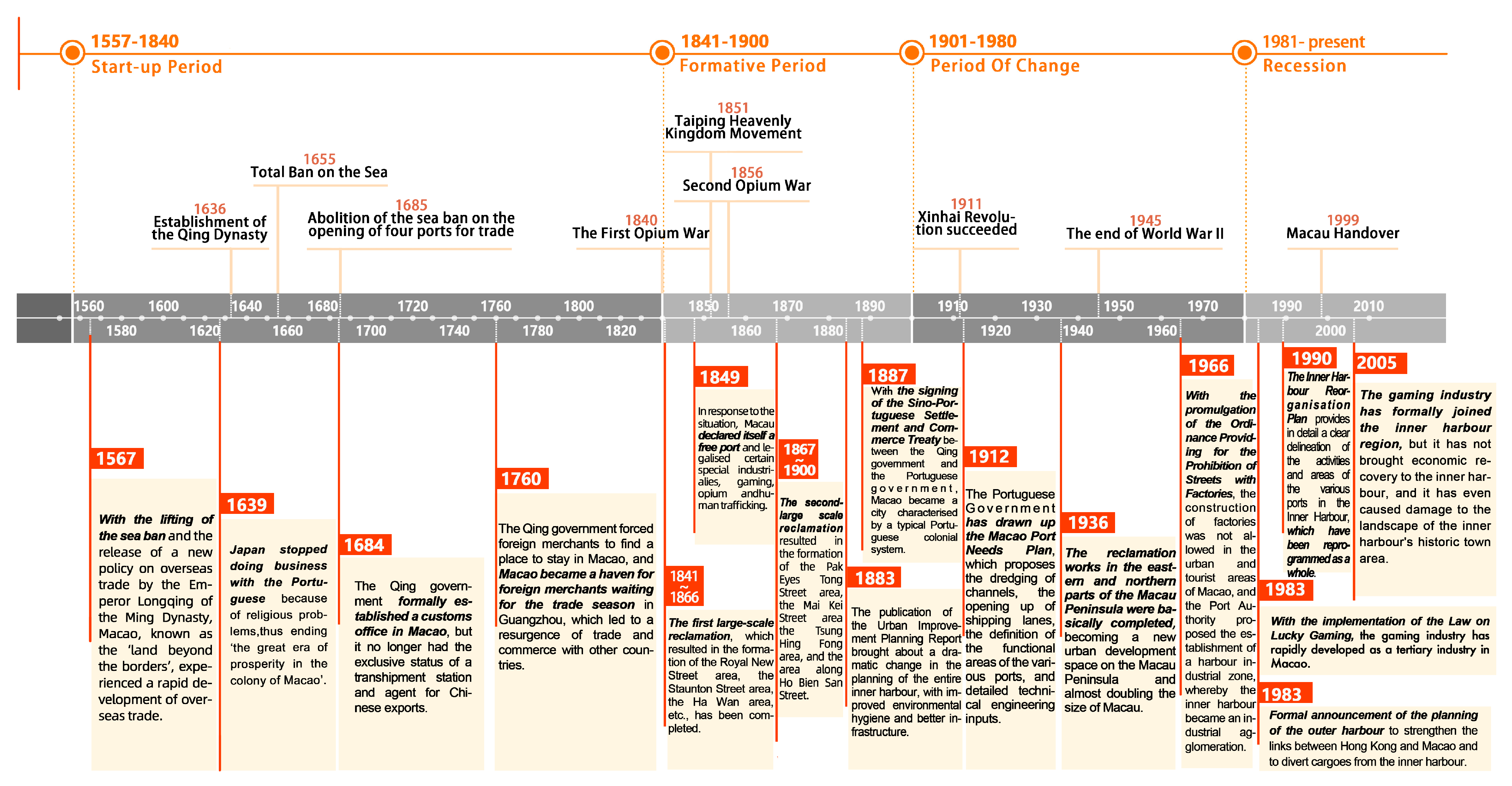
In the past, Macau’s domestic shipping could reach ports along the southwestern coast of Guangdong and Guangzhou, and its land and water transportation was quite convenient. It had the geographical advantage of “internal and external connections, external and internal connections” as a trade transit point and was an important node in the international trade network at that time. Since the beginning of the 16th century, the Portuguese began to gradually demonstrate their business management characteristics in Macau. The historical development and evolution of the Macau Peninsula pier district, as shown in
Figure 3, records the four historical periods of this area, from its initial stage to its decline, as well as the major events with far-reaching impact that occurred in each historical period.
2.2. Research Methods
Based on POI kernel density analysis and space syntax theory, this study constructs a spatial evaluation framework for the sustainable development of Macau’s Inner Harbor area. By measuring the core density of POIs, the spatial agglomeration characteristics of economic elements such as commerce and services are quantified, revealing the distribution pattern of regional spatial vitality. At the same time, the road integration index is used to analyze the impact of road network topology on the accessibility of functional space layout.
2.2.1. POI Kernel Density Analysis
POI (Point of Interest) refers to the data in a Geographic Information System (GIS) that can be abstracted as points. These points represent geographical entities in the real world, such as stores, restaurants, hotels, parks, etc. POI data are widely used in fields such as urban spatial analysis, business layout research, and tourism planning due to their rich content, timely update, and high accuracy [
47]. To study the types of businesses and industries in the Inner Harbour, this research used a method called Point of Interest (POI) extraction from urban electronic maps. Through the analysis of POI data, the spatial distribution characteristics of various facilities within the city can be intuitively understood, thereby providing a scientific basis for urban planning, commercial development, traffic optimization, etc. With the continuous development of Macau’s economy, the Inner Harbour has been influenced by the economic and industrial transformation of the Macau Peninsula and the broader region, resulting in ongoing updates and advancements in its economic and industrial landscape. These point-based geographic big data can describe the spatial and attribute features of geographic entities in real-time, such as coordinates, addresses, and names.
Kernel density estimation was employed for visualization [
48]. This method is widely used and effective for measuring the clustering degree of POI datasets, providing a clear representation of the number of relevant POIs within the study area. It captures the continuous and regional characteristics of the research target by calculating the number of features and spatial weights within a specific distance [
47,
49]. Additionally, it visualizes data results by identifying clustering levels of POI points in different areas. Finally, the collected data were analyzed using the ArcGIS software (version 10.8) to conduct kernel density analysis within the defined area. In the process of kernel density analysis, this study adopted a unified kernel density bandwidth parameter setting to maintain horizontal spatial comparability among various functional facilities (catering, shopping, residence, life services, commerce, and transportation). Although this method cannot accurately simulate the behavioral service radius of each type of facility, it can better demonstrate the distribution trends and aggregation characteristics of various types of facilities at the same spatial scale. In early tests, we attempted to use a larger distance (like 800 m) for transportation facilities and a smaller distance (like 300 m) for catering facilities, but we discovered that the images produced at different distances were not consistent, making it hard to identify and compare the spatial connections. Considering that this study mainly focuses on the macro-distribution pattern of various functional structures in the inner port area, it is reasonable to choose a unified bandwidth. The bandwidth (search radius) used in the kernel density analysis was set to 500 m, and the cell size (output raster resolution) was set to 10 m × 10 m. This setting considers how far people typically walk in the city (5–10 min is about 300–800 m) and the crowded nature of the inner harbor area, which helps make the analysis results detailed while preventing issues that can arise from using a bandwidth that is too small. This simulated the density distribution of data on the map and examined the distribution characteristics and influencing factors. Since the absolute numbers of various POIs vary greatly (for example, the number of catering POIs is much higher than that of life services POIs), this study used adaptive color scale settings when drawing kernel density maps to ensure that each type of image has sufficient detail recognition. Although the method affects the uniformity of cross-figure comparisons to some extent, it helps to highlight the respective spatial clustering trends. This process provided an intuitive analysis of the urban functional structure and current characteristics of Macau’s Inner Harbour.
2.2.2. Space Syntax
Space syntax is a theory and method for quantitatively studying space. The fields of architecture and urban landscape have applied this theory [
50]. In the study of street and lane space in urban historical areas, the streets and lanes are converted into spatial systems with topological relationships, and the parameters such as accessibility and relevance that describe the spatial form are measured, thereby providing a reference for spatial layout. The spatial restructuring of Macau’s Inner Harbour has produced differentiated impacts across social groups. Tourists have benefited from the clustering of dining and retail facilities, which has significantly enhanced their experience; however, excessive commercialization may undermine the perceived authenticity of local culture. Residents enjoy convenience in the highly coupled service facilities, while businesses expand their business opportunities in the multi-functional spaces. It presents a diversified development trend of the social economy. This study mainly uses the axis analysis method in space syntax to turn the internal streets into axes, creating a model for analysis and calculating different variables in space syntax. In terms of analysis parameters, this paper uses the commonly used variables in space syntax: integration, choice, and depth. The specific meanings of each variable are as follows: (1) Integration: an indicator that measures the degree of connection between a point or an area in space and other parts. It reflects the accessibility and centrality of the spatial unit in the entire spatial system. Simply put, a space with high integration means that the space is easily connected with other spaces, and people or information can flow through it more easily. It is the core area in the spatial structure, while a space with low integration is relatively isolated and not closely connected with other parts. (2) Choice: mainly used to describe the probability or tendency of a path or area in space to be selected among many possible paths. It reflects the guiding role of space in the flow of people, logistics, etc. Paths or areas with high choice are often preferred by people when moving in space because they may have better visibility, more convenient connectivity, or be more in line with people’s behavioral habits. Meanwhile, it might be about potential conflicts. For example, areas with high choice values might suffer pedestrian congestion or vehicular bottlenecks, etc. (3) Depth: In space syntax, depth refers to the minimum number of spatial transformations or steps required to go from one spatial unit to another spatial unit. It reflects the complexity of the spatial hierarchy and accessibility. The smaller the depth value, the more direct the connection between the space and other spaces, and the higher the accessibility; the larger the depth value, the more indirect the connection between spaces, and it requires more intermediate spaces to reach. In terms of the relationship between integration and functional concentration, although the heritage buildings and public space layers are not directly superimposed in the image, to avoid interference from map information, this study has pointed out in the analysis text that some high-commercial-density areas are highly coupled with high-integration paths.
2.3. Data Sources and Processing
This article analyzes the POI data of Macau’s Inner Harbour economic-related industries using the Python (version 3.13.0) language applied to the Amap open platform data. It is mainly based on GIS data and POI data. GIS data come from the 2025 digital map of Macau provided by the Cartography and Cadastre Bureau of the Macau Special Administrative Region. The map POI data are taken from the open map API of Amap in October 2024. By fixing errors in the data and checking for duplicates along with on-site research, the Inner Harbour area was marked on the map, resulting in 5733 data items that created six types of POI data related to the activities and businesses in Macau’s Inner Harbour area. Amap is a mainstream electronic map platform with fast data collection, short update cycle, strong timeliness, and comprehensiveness. The data are rich in variety, highly targeted, fair, and scientific, and can ensure the accuracy and representativeness of this study.
The POI classification standard—based on TYPE2 in the secondary classification table of the main commercial classification for the POI classification code in AutoNavi map data. The researchers analyzed the data using numbers and categories, used ArcGIS software to study how the data are spread out, created a map showing this spread, and produced visual images to easily understand the urban functional structure and development of Macau’s Inner Harbour waterfront area. To ensure the integrity and representativeness of POI data, this study conducted a two-step verification process after data crawling. Firstly, the collected POI data were deduplicated, classified, and corrected, and semantic consistency was checked to eliminate redundant and incorrectly labeled items. Secondly, using the “Statistical Geographic Information System” (
https://www.dsec.gov.mo/gis/unidade/?lang=en, accessed on 26 October 2024) from the Government of Macau Special Administrative Region Statistics and Census Service, the Macau cadastral map, and other official data, along with visits and surveys, the POI points were checked and confirmed in real life, especially looking at non-commercial areas like homes and everyday services. Although the industrial and commercial registration database was not directly called, the above cross-validation process has effectively reduced data bias and improved the capture rate and spatial distribution accuracy of non-commercial facilities. In view of the large number of mixed-function buildings in Macau’s old city (such as historical district buildings with “living upstairs and commercial functions downstairs”), this study strictly distinguished between residential facilities and commercial facilities during the classification process. The specific approach is only when the POI is marked as a “residential community”, “residential building”, or other clear residential function in the Gaode map will it be classified as residential; if the POI is a shop or other non-residential function, it will not be included in the residential statistics, even if it is located on the ground floor of a residential building. Entries with overlapping functions or ambiguous classifications will be reviewed through street view images or on-site surveys to reduce misjudgments. Even though there are unavoidable classification uncertainties in some mixed buildings, kernel density analysis uses a lot of data and can effectively lessen the effect of individual mistakes on the overall analysis of spatial patterns.
In order to accurately reveal the spatial structure and functional layout characteristics of the Macau’s Inner Harbour, this study takes the Macau’s Inner Harbour as the research object, adopts the POI data kernel density analysis method, and systematically analyzes the spatial distribution of the overall points of interest (POI) in the region and the POI data of six types of business types, including catering facilities, shopping facilities, residential facilities, life service facilities, commercial facilities, and transportation facilities. Using kernel density analysis, we clarify how different facilities are spread out, identify key issues in the current layout, and explore the specific reasons for these issues, which helps provide a scientific foundation for planning and sustainable economic growth in Macau’s Inner Harbour.
Therefore, this study adopts a method combining POI kernel density analysis with space syntax, which not only reveals the spatial distribution pattern of urban functions in the inner harbor area but also quantitatively describes the coupling relationship between its road network and functional nodes through multi-scale variables (such as integration, selectivity, depth, etc.). Compared with the traditional static analysis based on plots or functional areas, the spatial visualization and structural analysis technology based on big data introduced in this paper is more dynamic and refined, and can identify “functional penetration areas”, “service blind spots”, and “accessibility bottlenecks” in high-density old urban areas. Among them, functional penetration areas in this study refer to areas in high-density cities, such as Macau’s Inner Harbour, where different functional types (such as commercial, residential, office, leisure, etc.) are highly mixed and interpreted in space, which is manifested by the high density of POI cores and a significantly higher functional diversity index than the surrounding areas. Such areas usually have high potential for human interaction and complex spatial service capabilities. In this study, service blind spots refer to areas in high-density cities where residents have difficulty accessing basic public or commercial services due to insufficient spatial accessibility, imbalanced functional supply, or physical barriers. Service blind spots can easily lead to social equity issues (such as the elderly having to walk more than 30 min to seek medical treatment), exacerbating the phenomenon of “spatial deprivation”. This can be further analyzed in combination with the choice in space syntax. Similarly, “accessibility bottleneck” in this study refers to the key blocking points in the urban road network where people and logistics cannot flow efficiently due to insufficient node connectivity or limited road section capacity. It can be further analyzed in combination with the depth in space syntax. These analyses are not only conducive to deepening the understanding of the spatial organization mechanism of high-density waterfront areas but also provide an operational theoretical basis and spatial diagnostic framework for optimizing urban spatial structure, improving service efficiency, and promoting regional regeneration.
3. Urban Functional Structure and Current Characteristics of Macau’s Inner Harbour
This study is used to reveal the aggregation mechanism and spatial structure characteristics of various functional facilities in the inner harbor area, identify key issues such as spatial service blind spots, functional redundant areas, and organizational axes, and couple verification with the results of space syntax analysis so as to provide a spatial diagnostic basis for optimizing the urban functional layout and promoting sustainable renewal. The generation and analysis of various POI maps are carried out around this goal, and their application value in identifying the functional differentiation of the inner port, the conflict between tourism and residence, and the inequality of community services is reflected in the results chapter.
3.1. Spatial Layout of Catering Facilities
The spatial layout of catering facilities is characterized by a radial distribution with Avenida de Almeida Ribeiro as the core (
Figure 4). Along this trunk road and its adjacent areas, especially near Ruínas de São Paulo (大三巴牌坊), the spatial density of catering service facilities is significant, and it has developed into a high-density core area with the most concentrated catering industry in the Inner Harbour area. Along Avenida de Almeida Ribeiro, there are a large number of Chinese restaurants, Western restaurants, cafes, and dessert shops, with diverse business types that can meet the diverse dietary needs of consumers. Driven by tourism activities, the area near the Inner Harbour in the Historic District of Macau has also formed another more significant catering cluster. This area is mainly Chinese food, snacks, and pastry and dessert shops. Its services are for both locals and tourists. The business format is highly active, and the spatial layout closely aligns with the tourism industry. In addition, in the area of Rua da Praia do Manduco (下環街), especially at the intersection of Rua da Praia do Manduco and Rua de João Lecaros (李加祿街), a secondary cluster of catering facilities has emerged, mainly providing simple Chinese meals and fast food and serving mainly residents of the surrounding communities, reflecting a clear orientation towards life services.
The spatial distribution of Macau’s catering facilities is primarily shaped by three factors: commercial development, tourism, and residential population. In commercial hubs, vibrant economic activity and strong purchasing power drive high-density restaurant clusters. Tourist areas develop specialty dining options supported by visitor demand and government policies to enhance travel experiences. Meanwhile, residential neighborhoods establish convenient and affordable food service networks to meet daily needs.
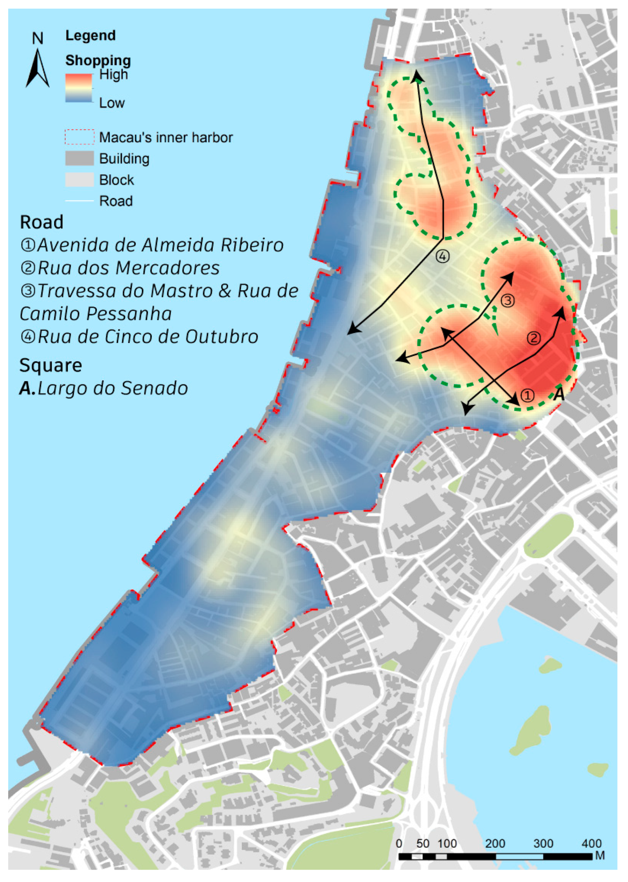
3.2. Spatial Layout of Shopping Facilities
The way shopping facilities are spread out shows a pattern of having two main centers and groups, which is clearly uneven (
Figure 5). The shopping facilities in the area are mostly found in busy neighborhoods, with the main concentration located in the blocks surrounded by Avenida de Almeida Ribeiro, Rua dos Mercadores (營地大街), Travessa do Mastro (爐石塘巷), and Rua de Camilo Pessanha (庇山耶街), creating a central area with a lot of shops and a wide reach. There are many shops in this area, covering various types of retail stores, specialty stores, and tourist souvenir shops, which serve both local residents and tourists. The second agglomeration center takes Rua de Cinco de Outubro (十月初五日街) as the development axis, and shopping facilities extend linearly in the north-south direction along this axis. Compared with the first core, this area is dominated by small and medium-sized supermarkets, grocery stores, and community markets; the service objects are mainly the surrounding permanent residents, with obvious life-service-oriented functions. The two main shopping areas are located next to each other and work well together, providing a good range of services and coverage, which makes up the main structure of shopping options in the Inner Harbour area of Macau. Among them, Avenida de Almeida Ribeiro is the core commercial artery of Macau, with diverse types of shops, rich business formats, and a strong business atmosphere, while Rua de Cinco de Outubro is the axis of a typical residential area, with shopping facilities that are closer to the daily needs of residents. In contrast, in the southwest part of the Inner Harbour, like the southern part of Rua da Praia do Manduco, Rua das Estalagens (草堆街), and Praça de Ponte e Horta (柯邦迪前地/司打口), there are not many shopping options, the business activity is low, and there are areas lacking services and functions that need to be addressed and improved in future planning.
The spatial distribution of Macau’s shopping facilities is primarily shaped by three key factors: population density, economic development, and tourism. Densely populated areas form neighborhood commercial networks of small-to-medium retailers catering to daily necessities (
Figure 6). Economically vibrant zones develop diversified, high-quality retail systems driven by business clusters and enhanced purchasing power. Tourist hotspots feature specialized retail spaces closely integrated with attractions to meet visitors’ frequent consumption demands.
3.3. Spatial Layout of Residential Facilities
Residential facilities in the Inner Harbour area of Macau present a spatial pattern of “three centers and clusters”, and the overall distribution is somewhat unbalanced (
Figure 7). Three areas primarily concentrate residential space: Ruins of St. Paul’s, Praça de Ponte e Horta, and Rua da Praia do Manduco. The distance between the centers is relatively close, usually only 1 to 3 streets apart, forming a relatively independent residential cluster with complementary functions. Among them, the residential density around Praça de Ponte e Horta is the highest, and its core area shows an obvious ring-shaped diffusion trend, with the density gradually decreasing outward. In contrast, due to the special land attributes, development intensity restrictions, and port functions, the residential facilities along the waterfront dock are relatively scattered, and the space utilization efficiency is low. Overall, the spatial layout of the Inner Harbour residential area is closely related to the convenience of urban life, the degree of infrastructure perfection, and the quality of the ecological environment.
The spatial distribution of residential space in Macau’s Inner Harbor is primarily shaped by three key factors: living convenience drives the development of mixed-use “residential-commercial integration” models, where walkable daily services attract residential clustering in vibrant commercial zones; infrastructure quality directly determines neighborhood attractiveness, promoting population concentration; natural environment enhances ecological livability to support high-density housing. This tripartite settlement pattern demonstrates a synergistic spatial logic combining functional diversity, rational planning, and ecological prioritization.
3.4. Spatial Layout of Living Service Facilities
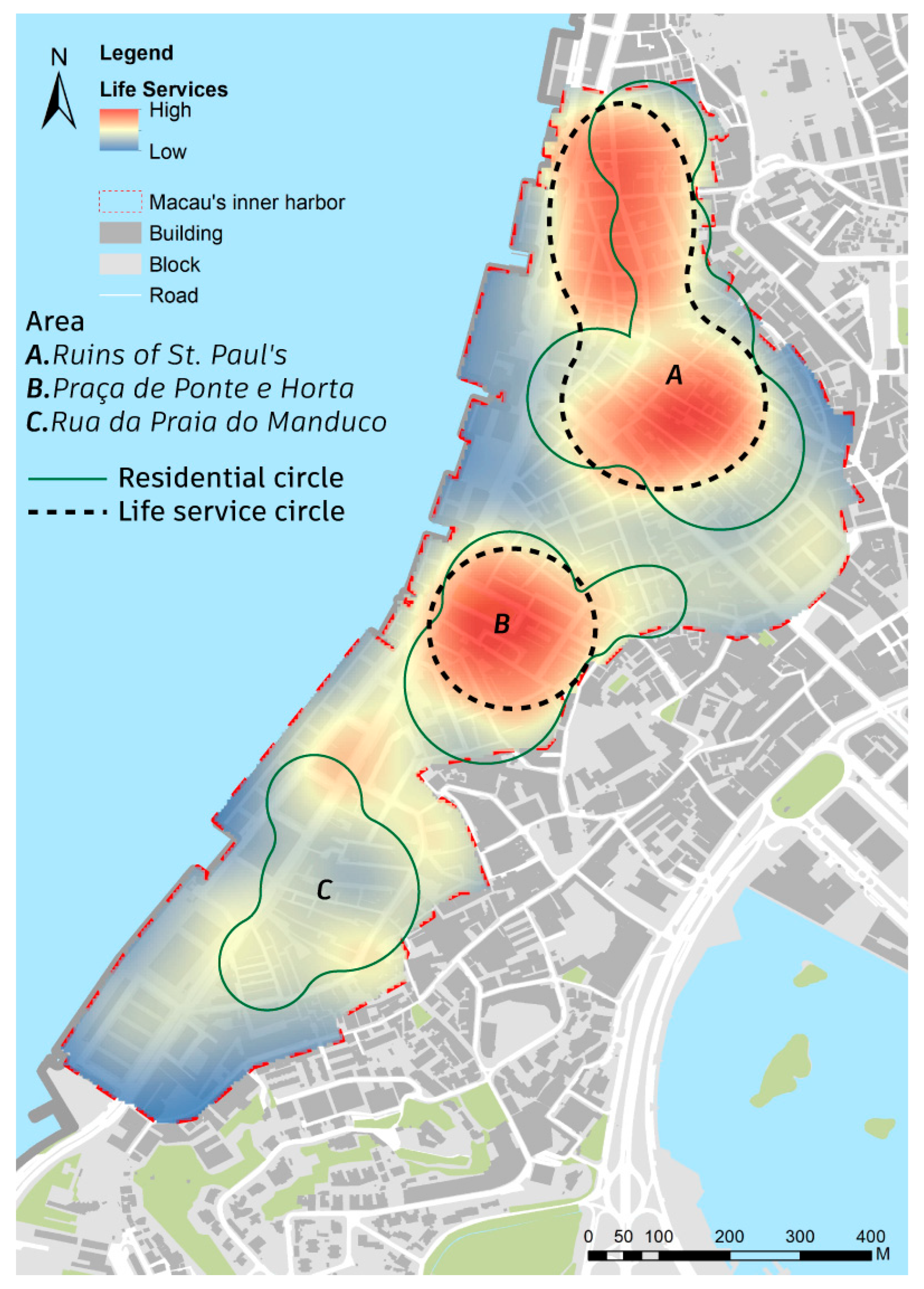
The spatial distribution of life service facilities in the Inner Harbour area generally shows a trend of high overlap with residential areas, but there is still a lack of supporting facilities in the Rua da Praia do Manduco area (
Figure 8). At present, the high-density areas of the life service industry are mainly concentrated in the Ruins of St. Paul’s and Praça de Ponte e Horta, forming two relatively clear life service core circles. Especially in the north of Avenida de Almeida Ribeiro and around the Ruins of St. Paul’s, life service facilities are relatively dense, including convenience stores, laundries, hair salons, maintenance service outlets, etc., building a multi-level service system, and the service objects cover local residents and foreign tourists. However, in the south of Rua da Praia do Manduco, although this area is one of the traditional residential areas, there is a clear lack of life service facilities, insufficient spatial service coverage, and low living convenience. From the overall spatial pattern, life service facilities show the unbalanced characteristics of “concentrated in the north and dispersed in the south”, and there is an imbalance in the allocation of spatial resources.
The spatial distribution of Macau’s life service industry is shaped by three key factors: population density, shifts in the consumer market, and urban functional positioning. Traditional residential areas, such as the Ruins of St. Paul’s, have become clusters of service facilities due to their stable customer base. As residential functions shift, high-density population zones continue to attract service-oriented businesses. In contrast, areas like Rua da Praia do Manduco face development lags in service facilities due to land policy constraints, leading to structural imbalances between supply and demand.
3.5. Spatial Layout of Commercial Facilities
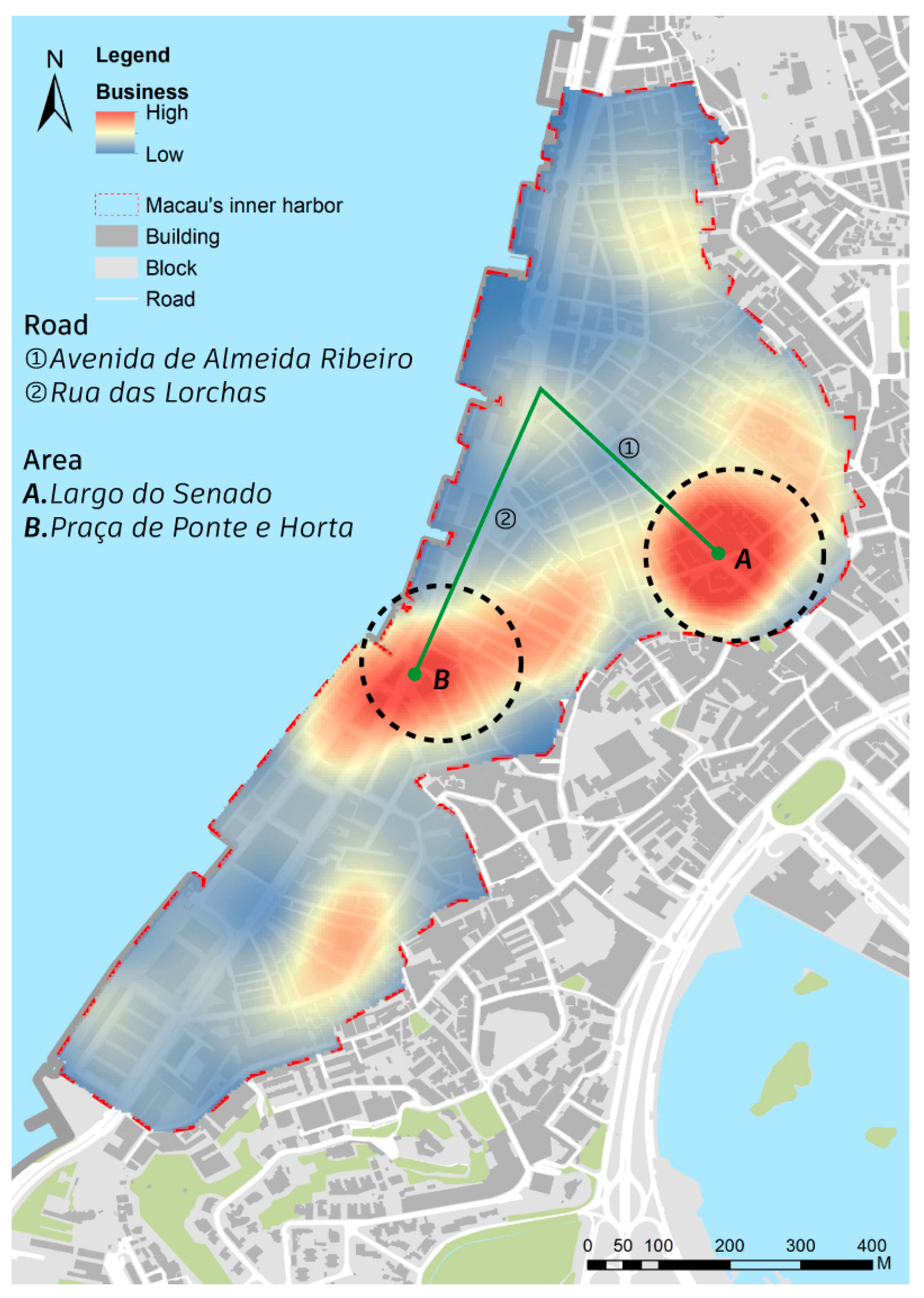
The commercial facilities in the Inner Harbour area of Macau present a typical spatial pattern of “dual cores and axial linkage”, and the overall distribution is carried out in the southwest-northeast direction (
Figure 9). Among them, Largo do Senado and Praça de Ponte e Horta constitute the two major agglomeration centers of the commercial space, forming an axial interconnection structure through urban trunk roads such as Avenida de Almeida Ribeiro and Rua das Lorchas (火船頭街), and building a backbone network for functional interaction within the region. The blocks with Largo do Senado as the core and extending to Avenida de Almeida Ribeiro have formed a commercial axis with a high density of enterprises. The area has a significant concentration of small and medium-sized enterprises, and the industry types are diverse, covering finance, tourism intermediaries, retail headquarters, design and consulting services, etc., presenting a highly active business ecosystem. At the intersection of Praça de Ponte e Horta and Rua das Lorchas, a certain scale of company enterprises can also be seen, indicating that the node has excellent traffic accessibility and supporting carrying capacity. Furthermore, there is a relatively sparse distribution of enterprises in other areas, suggesting the absence of an obvious agglomeration effect.
The spatial organization of commercial facilities in Macau’s Inner Harbour is primarily shaped by population density, infrastructure support, and functional integration. High population areas offer both a stable labor force and a diverse consumer market, making them natural hubs for business activity. Enterprises also favor locations with strong transportation access and comprehensive amenities—such as Avenida de Almeida Ribeiro and Rua das Lorchas, which facilitate operations and attract workers. Furthermore, mixed-use zones like Senado Square enhance commercial clustering by combining tourism, retail, and office functions. Together, these factors create a “dual-core and axial expansion” pattern, reflecting the strong link between commercial distribution, urban density, and mobility, and offering a foundation for more balanced and efficient urban development.
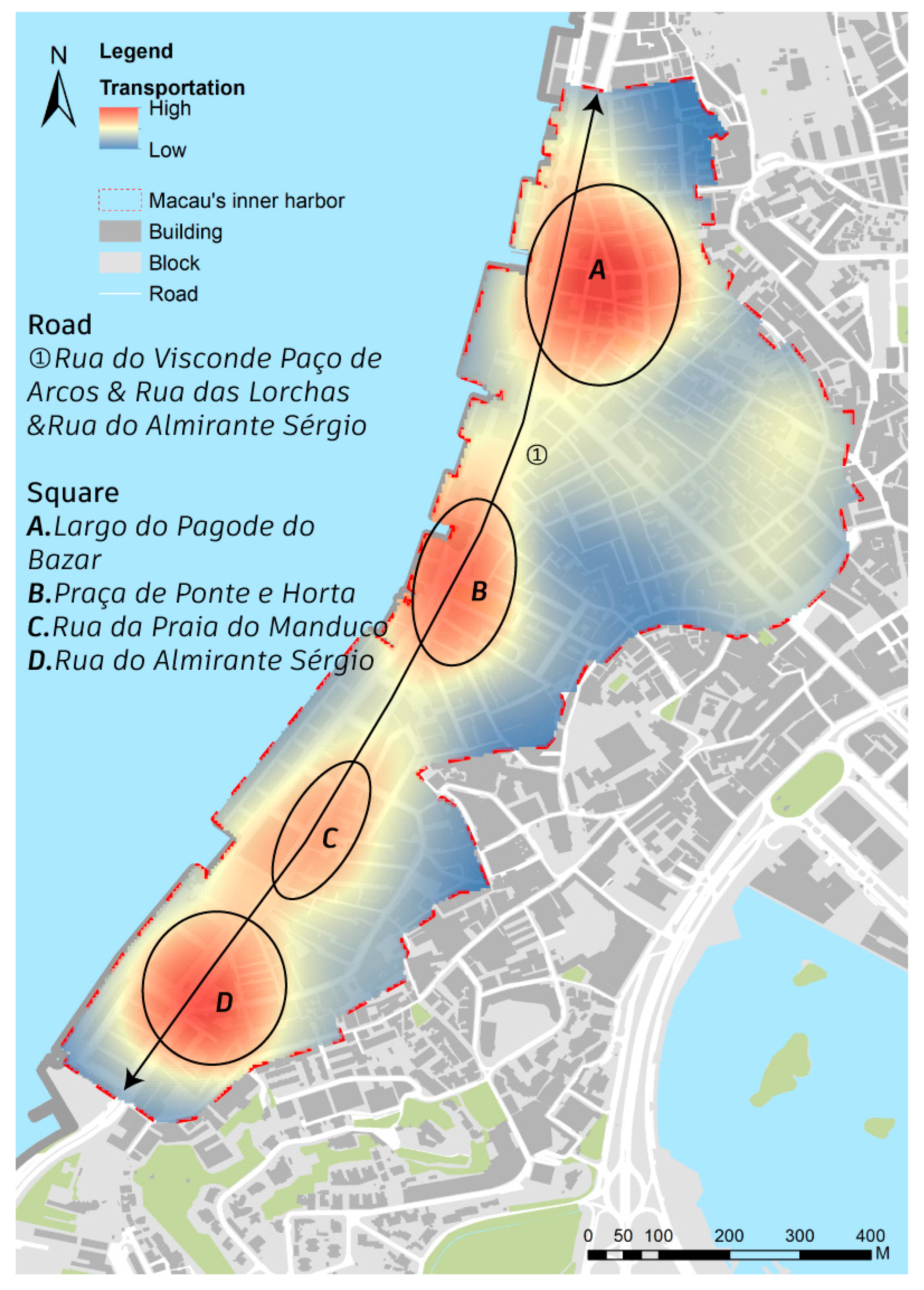
3.6. Spatial Layout of Transportation Facilities
The spatial layout of transportation facilities in the Inner Harbour area presents the regular characteristics of “point-like aggregation and axis distribution”. The overall layout is linear along the main coastal roads, such as Rua do Visconde Paço de Arcos (巴素打爾古街), Rua das Lorchas, and Rua do Almirante Sérgio (河邊新街), and the spacing between facility nodes is relatively uniform (
Figure 10). This layout shows how transportation facilities rely on the main road system, emphasizing their essential roles and services in the city.
The spatial distribution of transportation facilities in Macau’s Inner Harbour is shaped by urban form, service requirements, and population patterns. The area’s narrow layout—bounded by mountains and the coast—limits high-capacity roads to coastal corridors, concentrating transportation facilities along these trunk routes. Limited land and dense street grids further constrain space, making main axes like Rua do Visconde Paço de Arcos the backbone for transit infrastructure. Facility placement also aligns with population density and key functional nodes: high-traffic commercial zones like Praça de Ponte e Horta have dense, closely spaced transit points, while residential areas prioritize commuting convenience and equitable access. Overall, this “structural + functional” layout forms a tiered network that balances spatial constraints with diverse mobility needs, enhancing citywide accessibility and efficiency.
3.7. Summary of the Spatial Form of the Inner Harbour Waterfront Area
Macau’s urban functional structure is characterized by a highly compact, efficient, and mixed-use spatial pattern, with commercial, residential, tourism, transportation, and service functions deeply interwoven and mutually reinforcing, particularly in the Inner Harbour area. High population density and limited land resources have driven the development of integrated spatial uses. Commercial, dining, retail, and service facilities are concentrated along major traffic corridors such as Avenida de Almeida Ribeiro and Rua das Lorchas, where convenient access and comprehensive infrastructure reduce operational costs and enhance business clustering. Mixed-use hubs like Largo do Senado and Rua do Visconde Paço de further amplify commercial intensity through the synergy of commerce, tourism, and cultural functions.
Residential spaces, shaped by factors like livability, infrastructure, and environmental quality, follow a “commerce-residence integration” model. This has led to a tri-core residential pattern anchored in zones with well-developed amenities, boosting both accessibility and livability while supporting the sustained growth of service industries and local consumption. The spatial layout of transportation infrastructure closely aligns with urban morphology and functional nodes, forming a structured, layered network along primary corridors that effectively connects high-traffic commercial areas and residential zones, balancing commuter convenience with equitable access.
Overall, Macau’s current urban functional structure reflects deep spatial integration and refined organization in response to high-density pressures. It features a pattern of functional mix, axial extension, and node intensification, meeting the diverse needs of residents and tourists alike, while laying a strong foundation for future urban renewal and spatial optimization.
4. Characteristics of the Road Network Structure in the Inner Harbor Area
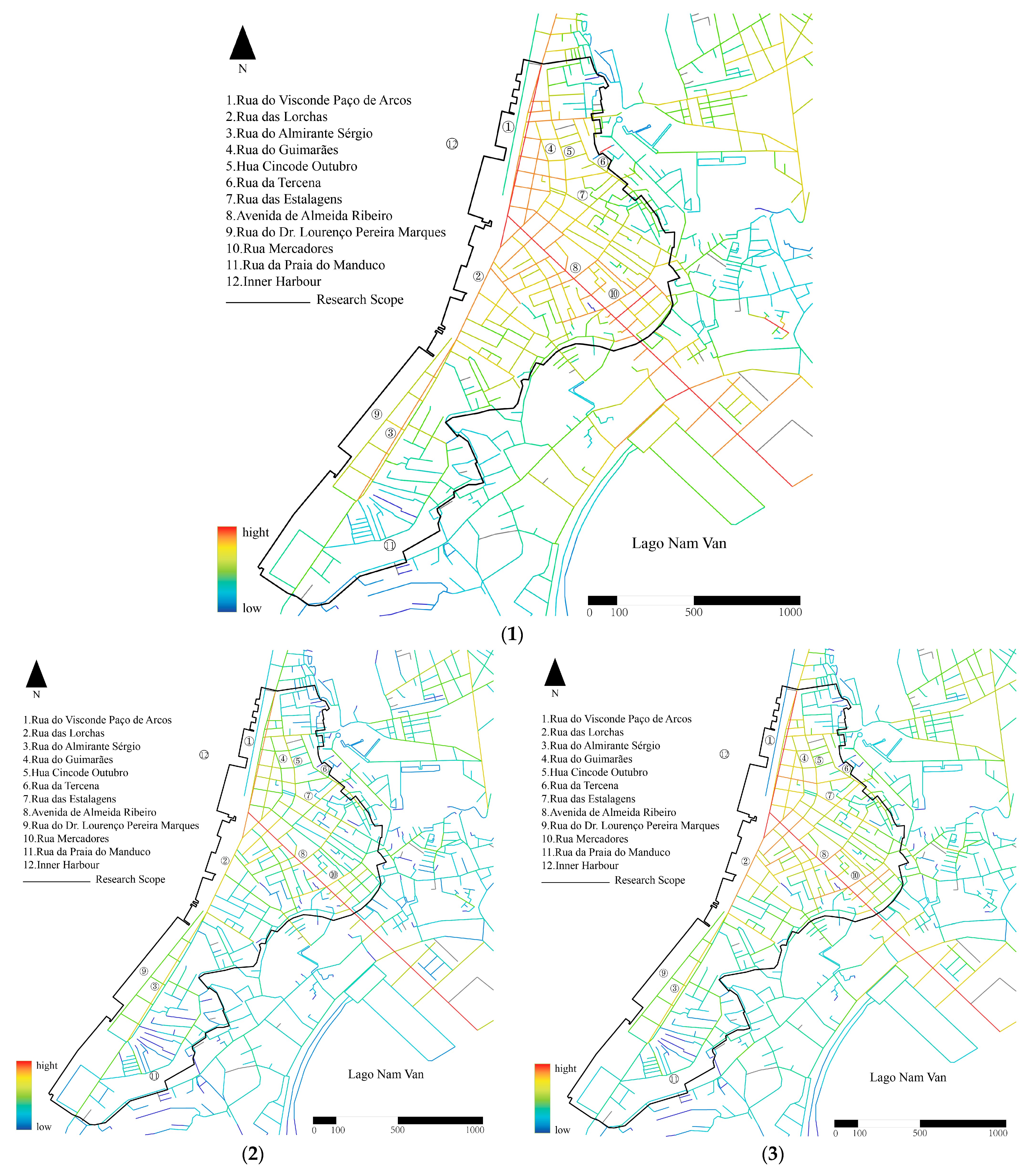
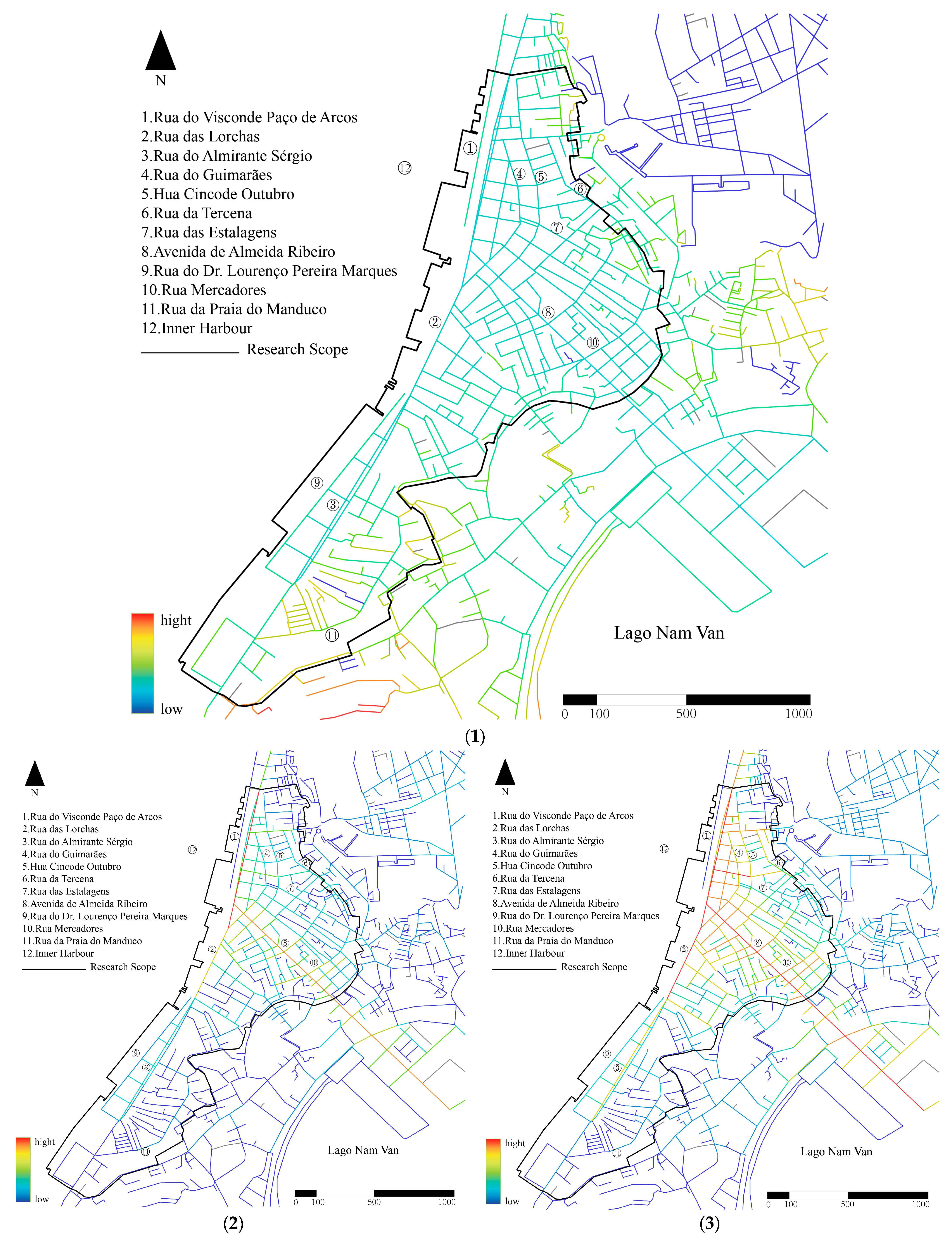
The integration, choice, and depth characteristics of the road network in the inner port area were systematically analyzed using the space syntax method, revealing that the traffic structure with the northern main road as the core has good accessibility and spatial guidance. This structure not only supports the efficient operation of internal urban mobility but also reflects the spatial evolution trend of the inner port from a traditional single center to multiple nodes. The findings of the space syntax analysis strengthen the fundamental role of the road system in organizing urban space and shaping urban order, and provide a key reference for improving the accessibility of the old city and people-oriented transportation strategies in the future. Based on the analysis method of space syntax, the central axis of the inner port in GIS is extracted, a line segment model is constructed, and the analysis parameters with four different search radii are set as 300 m, 500 m, 1000 m, and 1500 m. Among them, the 300 m radius is suitable for walking time ranges of from 3 to 5 min, usually covering the core area of the inner port area; the 500 m radius is suitable for walking time ranges of from 5 to 10 min, usually covering the inner port area and adjacent areas; the radius of 1000 m is applicable to the walking time range of from 10 to 15 min, which can cover the Inner Harbour and its wider surrounding areas, and is used to analyze the spatial relationship between the Inner Harbour and areas within a larger scope, and to clarify the influence and radiation range of the Inner Harbour in a broader area; and the 1500 m radius is suitable for walking time ranges of 15 to 20 min, which can cover a larger area, including some outer ring areas. This also meets the need for analysis radius division in the boundary effect of space syntax. Under different search radii, the integration, choice, and depth are analyzed, and the analysis results of the four search radii are obtained, respectively (
Table 1).
The results of the integration analysis of Macau’s Inner Harbour are shown in
Figure 11 below and show the following characteristics: (1) In global integration, the core integration is the Pier 16 area near the sea in the north, and gradually decreases with this area as the center. Therefore, for large-scale travel by car, the most connected areas are usually the two main roads in the northern Inner Harbour, Rua das Lorchas, Rua do Visconde Paço de Arcos, Avenida de Almeida Ribeiro, and Rua do Almirante Sérgio, followed by Rua de Cinco de Outubro (十月初五日街) and Rua do Guimarãe (海邊新街), highlighting the important role of Macau Inner Harbour as a transportation center. (2) In the local integration of a radius of 300 m, as a destination for walking travel, the overall integration is relatively strong, and the area with the highest accessibility is near Avenida de Almeida Ribeiro. Secondly, the Paço de Arcos Street in the northern area connects multiple roads and has the second highest integration. Overall, the area near the two main roads in the Inner Harbour of Macau is a relatively ideal area within a from 3 to 5 min walking distance. (3) In the local integration within a radius of 500 m, the overall integration has improved, and the integration of the northern area has improved significantly, indicating that the northern area has good spatial permeability whether in a short walk of from 3 to 5 min or a short walk of from 5 to 10 min. (4) There is no significant difference between the radii of 1000 m and 1500 m in terms of integration. This indicates that the spatial structure of the Inner Harbour has strong stability and coherence under these two scales, and the local spatial connection patterns and interaction relationships do not fluctuate significantly due to the moderate change in the radius. (5) In the local integration within a radius of 1500 m, it is like global integration. In summary, the core integration of the Inner Harbour is concentrated near Pier 16 and the northern area. Among them, the two main roads have better accessibility for motor vehicle travel, and the northern part of the Inner Harbour has better accessibility for long and short-distance walking, while the area near Rua da Praia do Manduco has the worst accessibility.
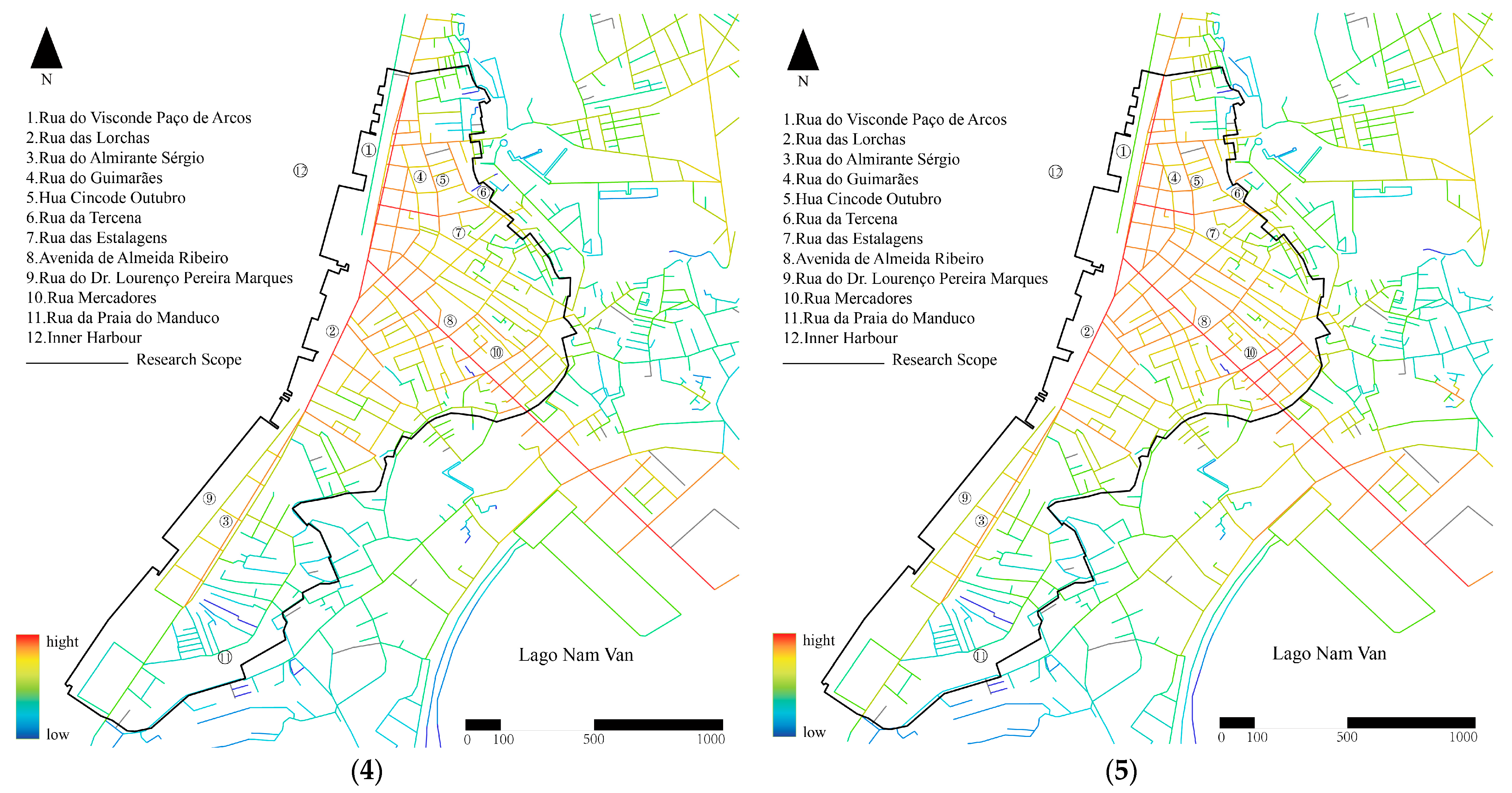
The results of the choice analysis of the Inner Harbour of Macau are shown in
Figure 12. (1) In the global choice, the areas with the highest choice are the two main roads, indicating that for motor vehicle-based travel, Rua das Lorchas, Rua do Visconde Paço de Arcos, Avenida de Almeida Ribeiro, and Rua do Almirante Sérgio have the highest degree of traversability and are the main traffic arteries. (2) In the local choice of a 300 m radius, the area with the highest choice is Avenida de Almeida Ribeiro. This road passes through a large number of road networks, so it has a high degree of traversability and has excellent traversability conditions for short-distance walking. (3) In the local choice of 500 m radius, the area with the highest choice is similar to that of the 300 m radius, indicating that Avenida de Almeida Ribeiro has a high potential for traversal traffic in a 10 min walk. (4) In the analysis of the choice of 1000 m and 1500 m, there is no significant difference between these two radii. (5) In the local choice of 1500 m radius, the choice of Rua da Felicidade (福隆新街) in the north becomes higher. In summary, although the overall and local choices of the Inner Harbour of Macau are relatively weak, some roads show outstanding traffic value at different travel scales. Rua do Almirante Sérgio and Rua das Lorchas, as major traffic arteries, have high passability for motor vehicle travel, while Avenida de Almeida Ribeiro shows good passability for both long- and short-distance walking scenarios. Rua da Felicidade has a high potential for walking traffic in a 1500 m radius.
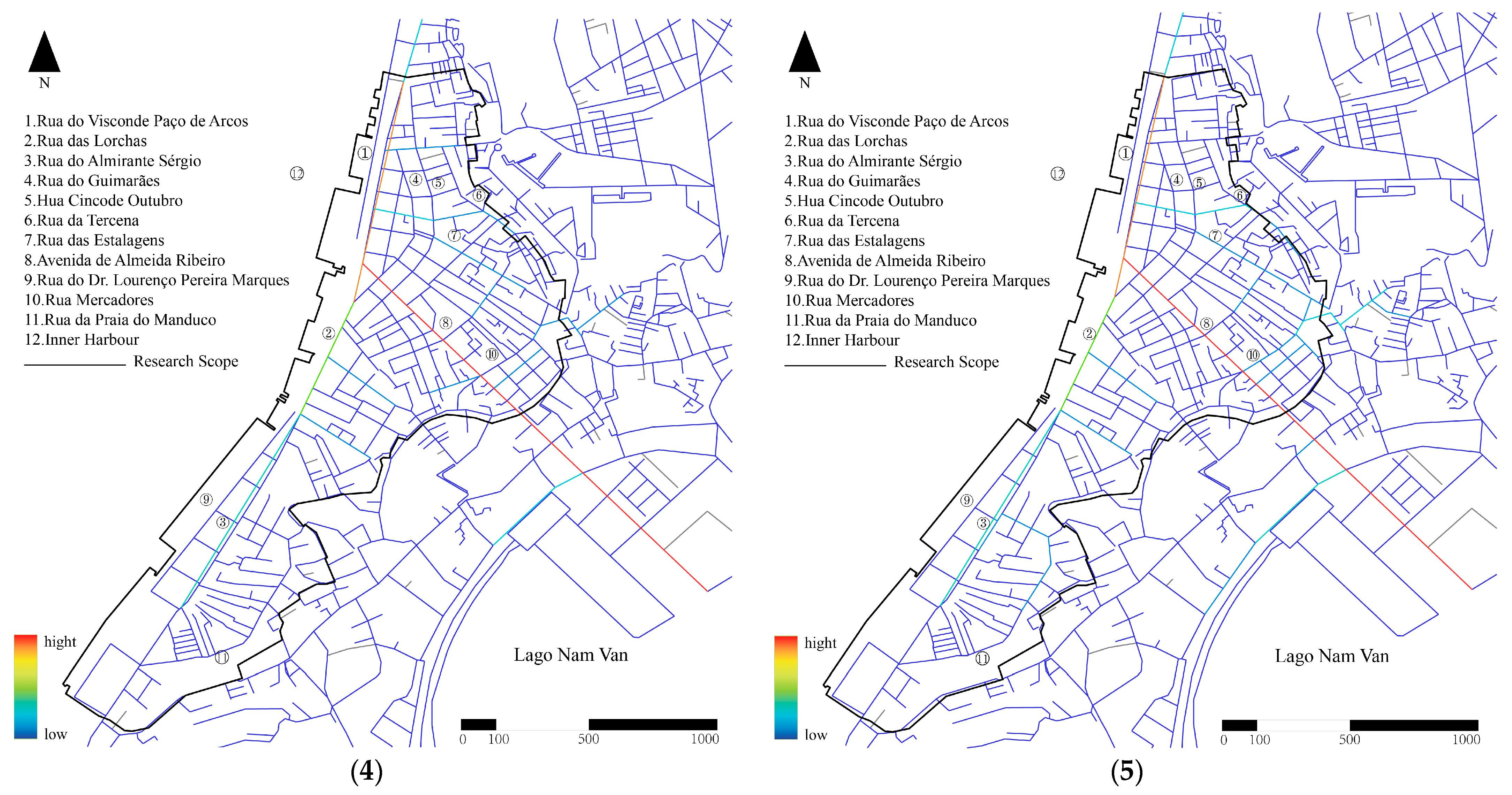
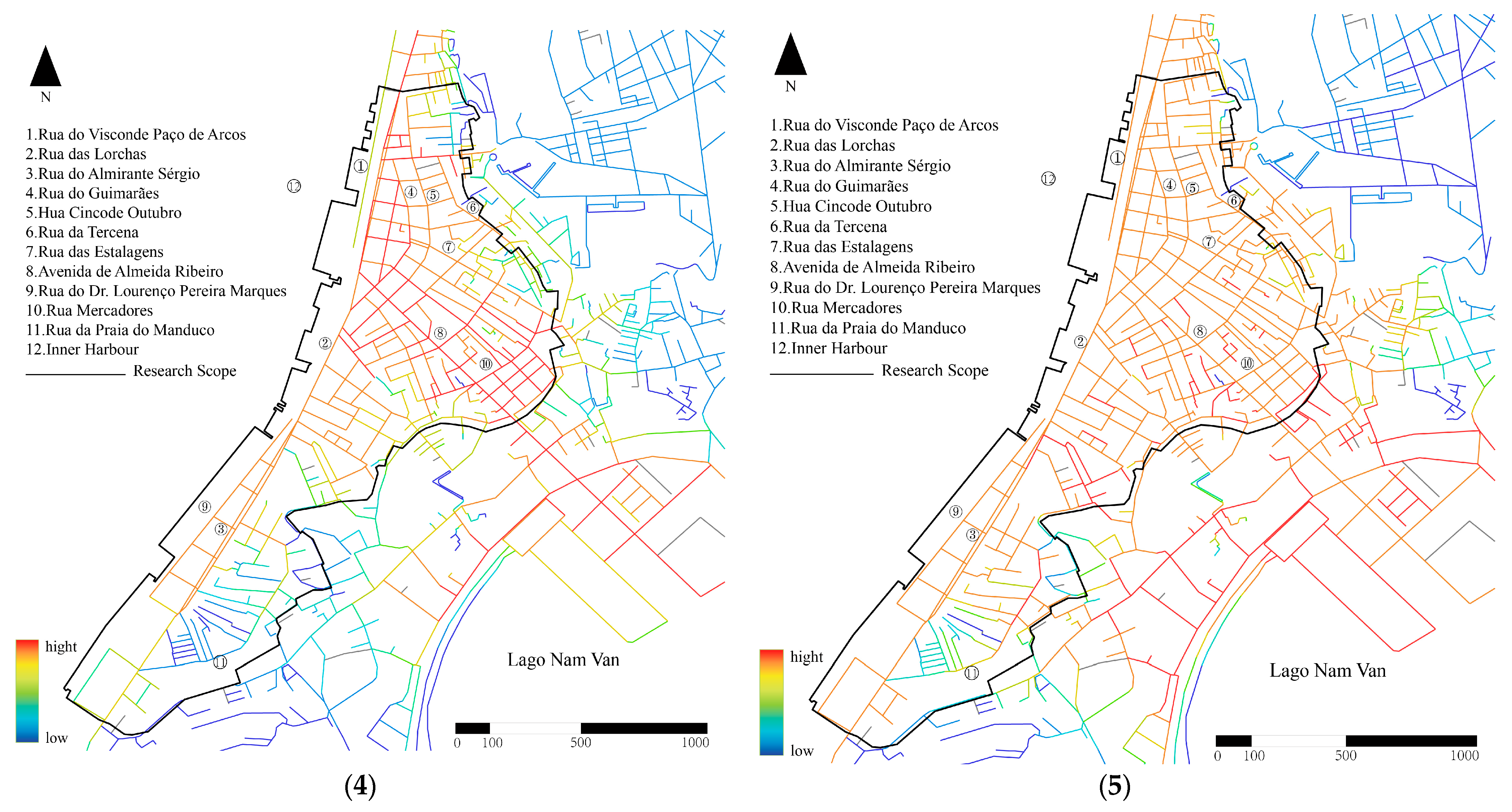
Figure 13 presents the depth analysis of Macau Inner Harbour, highlighting the following key features: (1) The global depth distribution is relatively uniform, indicating that the connectivity of the entire Inner Harbour area is strong, which is consistent with the characteristics of busy traffic in the Inner Harbour area. (2) The area with the highest depth has moved to the southern area, near Rua da Praia do Manduco, but its central area is contrary to the actual situation, and the local depth of this radius is not very referenceable. (3) In the local depth of 1500 m radius, the analysis results show that the depth near Avenida de Almeida Ribeiro increases significantly, indicating that within a radius of one thousand meters, Avenida de Almeida Ribeiro is the core street in the area. It plays a hub role in the spatial structure, connecting many other streets and promoting spatial integration and vitality in the area. (4) In the local depth of 1500 m radius, the area with the highest depth is still relatively balanced. In summary, in the depth analysis of Macau Inner Harbour, the global depth distribution is uniform, which shows that the entire Inner Harbour area has good connectivity and is consistent with the actual characteristics of busy traffic; although the local depth data of 300 m and 500 m radius are contrary to the actual situation when pointing to the central area and have poor reference, the local depth distribution of 1500 m radius still remains relatively balanced.
This space syntax analysis not only reveals the spatial characteristics of the existing road network in Macau’s Inner Harbour but also provides deep insights into the optimization of urban structure. The rational layout of the urban road network is the key to improving urban accessibility and traffic mobility. This study provides specific improvement directions through the analysis of indicators such as integration, selectivity, and depth. These analysis results have important practical significance for urban planners: the northern part of the Inner Harbour and its main roads are the core of the traffic network, which is of great significance for both long- and short-distance walking and motor vehicle travel. According to the spatial syntax analysis results, areas with higher integration have higher usage frequency and pedestrian flow. In the spatial syntax analysis, it can be found that, in the entire Inner Harbour area, there are two axes with a relatively high integration. There are three main broad waterfront roads, namely, Avenida de Almeida Ribeiro, Rua do Almirante Sérgio, and Rua do Visconde Paço de Arcos, which are important integrating elements in this area. The other parts of the area are characterized by intricate and irregular grid-like streets, most of which are one-way, narrow streets extending mainly towards the Inner Harbour. Avenida de Almeida Ribeiro is another main road in the area, connecting the Inner Harbour with the Outer Harbour. Therefore, the intersection of these two axial roads has become a key node in the road network of this area. Since the opening of the Sai Van Bridge in 2004, these two axial roads and their intersection have been under great traffic pressure, which is caused by the increasing traffic flow between Taipa and other areas. These traffic conditions have caused serious air and noise pollution, having a negative impact on the area, which is also reflected in the analysis of the choice degree. From the perspective of motor vehicle travel, as shown in the results of the global choice analysis, except for a few main roads such as Rua das Lorchas and Rua do Visconde Paço de Arcos with relatively high choice degrees, the passability of most roads is low, meaning that these roads are not the preferred routes for motor vehicle travel and have a small traffic flow, failing to fully play the role of diverting traffic. In terms of walking travel, even in short-distance walking scenarios, except for individual roads such as the Avenida de Almeida Ribeiro with relatively high choice, the choice of other areas is weak. The depth distribution in the analysis is relatively uniform. This feature indicates that the connectivity of the entire Inner Harbour area is strong. This uniform distribution is in line with the actual characteristics of heavy traffic in the Inner Harbour area, indicating that the area has a good traffic foundation as a whole, and the connections between various parts are relatively close, which is conducive to the flow of people and goods. According to the
Inner Harbour Reorganization Plan, revised on 1 March 2002 [
51], the areas near Rua do Almirante Sérgio, Rua do Dr. Lourenço Pereira Marques, and Rua da Praia do Manduco are designated for non-port activities. According to the results of the spatial syntax analysis, the integration degree and depth of this area are also weak. For non-port activities, such spatial conditions may endow it with relatively independent and quiet functional characteristics, for example, it is suitable for laying out service industries, small-scale commerce, or residential functions with low dependence on transportation hubs. Therefore, future urban planning should further strengthen the traffic convenience of this core area, while considering how to reduce traffic pressure in surrounding areas and optimize traffic flow lines. Avenida de Almeida Ribeiro and its surrounding areas perform well in short-distance walking, and the further development of walking traffic should be encouraged. Measures such as increasing pedestrian paths and improving public facilities should be taken to improve the walking accessibility of the area and promote the sustainable development of walking traffic. In a large area, the depth analysis of the Inner Harbour shows good traffic mobility, but, in some local areas, the depth distribution of short-distance walking is not satisfactory. It is recommended to conduct further detailed analysis of these areas, especially regarding the connection between walking and public transportation systems, to further improve the spatial permeability and traffic mobility of these areas.
5. Discussion
5.1. Industrial Characteristics of Macau’s Inner Harbour Waterfront
In the ever-evolving modern consumer society, the city’s waterfront is an area with relatively high commercial value in the city. It is also a natural area where people can get close to water and nature. The waterfront facilitates the easier realization of high-value commercial activities. This article conducts a pioneering analysis of the ultra-high-density urban waterfront space in Macau’s Inner Harbour. In terms of research methods, by combining the dual verification of POI big data and spatial syntactic models, and through kernel density analysis, the distribution law of facilities is revealed. Quantifying spatial accessibility with syntactic variables breaks through the subjective limitations of traditional planning research. It provides a new perspective for analyzing the intrinsic connection between urban spatial structure and economic activities. This research finds that regions with a high degree of integration tend to be commercially intensive, reflecting the promoting effect of good connectivity on economic development. The absence of resources in low-integration areas reveals the issue of urban equity and affects the quality of life of residents. Combining the changes of POI in different types, the impact of policies and plans on spatial structure and resource allocation can also be evaluated. This method not only analyzes the economic space but also provides a quantitative basis for understanding the quality of life, fairness, and policy effects. In addition, this paper proposes an evolutionary model based on “functional area + multi-node networks”, the networked transformation mechanism of the Inner Harbour space driven by catering, shopping, residential, life service commercial, and transportation networks, etc., is revealed, and the spatial response logic of the traffic economy is clarified. The spatial cognitive paradigm of the ultra-high-density waterfront area in the Inner Harbour has been reconstructed. Macau’s Inner Harbour is a typical case of the “historical urban area + ultra-high density + coastal area”. Its conclusion has universal reference value for similar cities around the world. This paper has opened a new path for the research on urban development and is worthy of in-depth study and practical application by urban planners, researchers, and policymakers.
Kernel density is convenient for obtaining the continuity and regional characteristics of the research object. Since the Inner Harbour area is close to the Avenida de Almeida Ribeiro World Heritage Tourist Route, its sightseeing and other commercial activities are mostly occupied by the World Heritage Tourist Route, which indirectly leads to the plunder of the commercial value of the Inner Harbour area, and only the internal commercial value can be maintained. Since its opening as a port, the Inner Harbour has formed a pattern of “production determined by water”. In 1845, Macau was declared a “free port”, and the prosperity of the shipping industry in the Xi River Basin brought an opportunity for the development of the industrial space in the Inner Harbour. These include water-related industries such as fishing vessel repair and construction, and cargo transfer. In the 1940s, during the most prosperous period of the fishing industry in the Inner Harbour, more than 2000 fishing boats and 20,000 fishermen made Macau their home, and the industry once accounted for 25% of Macau’s GDP. The gambling industry has emerged sporadically in the Inner Harbour and has not yet become a pillar industry there. At present, along the 3500 m-long coastline of the inner Harbour, among the 34 historical piers, some are still in use, mainly for freight, inland waterway transportation, and fishing, and still play an important role. Therefore, we have determined that Macau’s Inner Harbour has an urban functional structure that is not dependent on the gaming industry but rather consists of water-related industries. It has characteristics of a waterfront. Macau’s economy is based on gaming, which has led to the decline of micro-water-related industries like fisheries and docks. This is also the main reason for the economic slump in Inner Harbour.
5.2. Spatial Distribution Pattern of Macau’s Inner Harbor
The changes in the layout of Macau’s Inner Harbor are not just caused by business growth or people moving in, they are shaped by various rules and systems, showing how modern cities manage space, land, and resources. If urban renewal policies only consider facility density, it will easily lead to an unbalanced state where “function stacking” and “service hollowing out” coexist, ignoring the fragility of historical blocks and the sustainability of residents’ lives. This study uses POI analysis combined with space syntax results to reveal the following socio-political-economic impact mechanisms that are characteristic of inner port/waterfront cities:
- (1)
Tourism-oriented spatial reconfiguration: The “dual-center radial clustering” of catering and shopping facilities is mainly guided by cultural heritage and tourist routes, forming a high-density commercial axis around Largo do Senado and the Ruins of St. Paul’s. This spatial structure was not formed naturally by the market but was the result of the superposition of cultural resource-oriented redevelopment and the “non-gambling” economic transformation strategy, which reconstructed the original urban life structure.
- (2)
Marginalization of living services and differentiation of residential areas: The “three-core distribution” of residential space reflects the trend of the original residents of the Inner Harbor gradually moving to marginal areas. Old urban areas have transformed into gathering places for the elderly or concentrations of low-income individuals. The fact that living service facilities are dense in the north and sparse in the south reveals the serious imbalance in administrative investment between the “main axis of tourism” and the “secondary axis of life”. This service imbalance reflects the structural problem that policies focus on the development of the tourism economy and ignore reinvestment in marginalized communities.
- (3)
Infrastructure path dependence and trunk belt focus: The “functional axis belt + node agglomeration” pattern of commercial and transportation facilities is the result of the inner port area being guided by the trunk road network, such as Rua das Lorchas, for a long time. As an early development axis, the convenient transportation and policy investment tendencies along the line have formed a “functional focus zone”, but they have also exacerbated the uneven distribution of public services among regions.
- (4)
The combined effect of spatial closure and institutional rupture: The inner harbor area is constrained by the “closed spatial boundary” formed by the coastline, historical districts, and reclaimed land, and urban renewal and facility configuration cannot expand naturally. At the same time, there is a division between the reclaimed land and the old city in terms of administrative planning rights and development mechanisms, which has formed an institutional spatial rupture and further aggravated the polarization trend of functional distribution.
5.3. Recommendations for Macau’s Inner Harbour Development
Although the area of Macau’s Inner Harbour is relatively small, we believe that it is possible to develop a tour route with small cruise ships as carriers to realize its economic value in the context of the Inner Harbour and the opposite side of the Zhuhai Wanzai River. The route connects the waters near the Inner Harbour and Zhuhai Wanzai and its surrounding areas, strengthens the economic cooperation between Macau and Zhuhai, and can effectively promote the urban development strategy of the two places to build a “leisure and tourism center” with diversified integration. In addition, Macau and Zhuhai have set up night tour routes, respectively. Macau departs from the Inner Harbour, and Zhuhai departs from Wanzai. Both routes can enjoy the beautiful night views of both sides of the strait. Some sightseeing boats also set up sightseeing, catering, performances, and other entertainment projects, which are a positive example of the common development of the economies of Zhuhai and Macau. We believe that there is potential to enhance cooperation between the two locations, establish a specific night tour mode, and broaden the water area available for sightseeing. In addition, Fai Chi Kei Bay, in the north, is a berth gathering place for small oil tankers in Macau. Here, a variety of entertainment activities aimed at achieving economic benefits take place, significantly boosting these benefits. In the future, if the scope of sightseeing within Macau’s managed waters can be expanded to the waters off Macau International Airport, the Cotai Strip that bypasses Taipa, Coloane, and the gaming and entertainment venues, as well as the area around Chimelong Water Park in Hengqin, Zhuhai, tourists will be able to have a more complete view of the scenery of both Zhuhai and Macau.
Based on the results of comprehensive spatial analysis, several strategic considerations are proposed around the sustainable path of the future development of Macau’s Inner Harbour. Through discussions on the regional industrial foundation, tourism potential, and the possibility of cross-city collaboration, it is pointed out that the Inner Harbor can reconstruct its economic space and functional value through water transportation, night tourism, and industrial diversification. These views strengthen the concept that urban renewal must be based on the coordinated promotion of multiple ecological, economic, and social goals, which has a practical guiding significance for solving the dilemma of old city renewal and realizing regional linkage development. Proposal for Inner Harbour Development to Macau Government: It is recommended to establish a cross-departmental “Inner Harbour Revitalization Committee” to coordinate transport upgrades, commercial revitalization and community facilities; develop cultural-tourism-commercial themed districts with improved pedestrian systems and smart navigation; collaborate with Zhuhai on water tourism to enhance cross-border cultural connectivity, while implementing real-time monitoring systems for better management. This integrated approach will balance heritage conservation with economic vitality through targeted planning and cross-sector cooperation, achieving dual socio-economic benefits.
6. Conclusions
This paper reveals the multi-dimensional development law of the ultra-high-density urban waterfront space in Macau’s Inner Harbour. POI data, as carriers of high-precision and dynamic urban spatial information, are of great value for optimizing the urban structure. By looking at where different types of Points of Interest (POIs) are located and what they do, this study found that various facilities in the Inner Harbor area of Macau are grouped together in specific ways. For instance, restaurants, shops, and other types of businesses are clustered together in a complicated way along the main tourist paths, showing how the city’s layout is heavily shaped by tourism. However, this study mainly focused on the identification and structural analysis of static distribution patterns and has not yet carried out dynamic modeling of the spatial interaction mechanism or spatiotemporal evolution laws between different POI categories. The spatial functional aggregation and alienation phenomena revealed by this study do not simply originate from the static distribution of POIs but are the result of the joint shaping of deeper urban processes. These include (1) spatial restructuring guided by the tourism economy, which promotes the concentrated development of commercial and catering facilities along the core traffic lines; (2) spatial unevenness in the supply of public services, resulting in a “service vacuum” in living facilities in some areas; (3) functional duplication and local space commodification caused by historical block policies and capital re-entry mechanisms; and (4) path dependence of the existing transportation network, which guides the functional layout to extend in a strip-like manner. The superposition of these processes constitutes the institutional basis for the spatial reconstruction of the Inner Harbor area and poses new challenges for future urban renewal.
This study also found that, through the kernel density analysis of six major urban functional facilities in the Macau’s Inner Harbour, the distribution of various POIs not only shows the regularity of coupling with the urban spatial structure but also exposes the problems of local layout imbalance and facility dislocation, reflecting the spatial tension and organizational complexity faced by the old city in the context of high-intensity functional overlap. These include (1) catering and shopping facilities present a dual agglomeration mechanism of “tourism-driven + commercial core”, with Avenida de Almeida Ribeiro as the main axis, radiating to the Ruins of St. Paul’s and Praça de Ponte e Horta, respectively. Its spatial center of gravity is obviously guided by historical blocks and tourist hotspots, indicating that tourism mobility has become an important force in reshaping the spatial layout of the inner port service industry, which not only increases the spatial density of related industries but also has a radiating effect on the form of other facilities. It is suggested to integrate Macau’s positioning as a “World Tourism and Leisure Center”, transform the Inner Harbour Fishery wharf into “Fisherman’s Wharf 2.0”, and combine seafood processing experience, fishing boat sightseeing and the construction of affordable housing to form a “port in front, residence at the back” industrial-city in-tegration model. (2) Residential and life service facilities are highly coupled, reflecting the spatial logic of “work-residence integration-service coordination”. The distribution of life service facilities basically overlaps with the high-density residential area, forming an obvious “living area + community unit” structure with clear spatial boundaries. This layout strengthens the internal self-organization ability of the residential area but also shows the problem of insufficient service coverage in the southern group, indicating that spatial balance still needs to be optimized. (3) Commercial and transportation facilities form a “functional axis belt” organizational structure along the main road, with the Rua das Lorchas-Rua do Almirante Sérgio axis as the skeleton, constructing a “functional verification functional area”. The location selection of companies and enterprises shows the population-dependent characteristics of “location selection based on people”, while transportation facilities are dominated by “structural supply”, showing a two-way adjustment mechanism between infrastructure and population-format demand. It is suggested that the Inner Harbour reclamation area and the historical urban area be updated in a coordinated manner, adopting a “stratified development” strategy. The commercial space on the ground floor of the arcades, a characteristic building of the Inner Harbour, should be preserved, and the abandoned wharf warehouses should be transformed into a “maritime culture museum cluster”, etc. (4) Through the spatial comparison analysis of different POIs, it is found that the spatial system of Macau’s Inner Harbour presents a networked connection structure. Its internal spatial differentiation is not only restricted by traditional land use functions but also driven by complex factors, such as tourism economy, residential migration, historical protection, and infrastructure accessibility. Especially in crowded historical city areas, “functional nesting” and “edge spillover” are new trends in how space is organized; this means that some shops or homes are starting to spread into less central areas, creating secondary hubs and lively edge zones, showing that the Inner Harbour functional system is changing and finding a new balance. (5) Through the analysis of space syntax, it is found that the core integration of the Inner Harbour is concentrated near Pier 16 and the northern area. The two main roads have good accessibility for motor vehicle travel, and the northern area of the Inner Harbour has good accessibility for long and short-distance walking. In the depth analysis of Macau’s Inner Harbour, the global depth distribution is uniform, which shows that the entire Inner Harbour area has good connectivity and is consistent with the actual characteristics of busy traffic; although the local depth data of 300 m and 500 m radius are contrary to the actual situation when pointing to the central area and have poor reference, the local depth distribution of 1500 m radius remains relatively balanced. However, since this study focuses on image recognition of the relationship between urban structure and spatial potential, the pixel-level spatial cross-correlation method has not been further introduced. In the future, spatial statistical tools such as cross-heat zone analysis can be used to more accurately verify the relationship between layers. Based on this study, future research can further explore the spatial coordination model of urban industrial functions, the coupling structure of service circles, and the modeling of industrial evolution trends based on time-series POI or industry business data to support more accurate multi-industry balanced development strategies and risk management mechanisms.


 ,
, 


