1. Introduction
Industrial heritage stands as a vital testament to industrial civilization, embodying profound historical, social, technological, economic, and aesthetic values, and constitutes an indispensable component of global cultural heritage. In 2006, the inaugural China Industrial Heritage Forum held in Wuxi marked a milestone with the release of the Wuxi Proposal, China’s first constitutional document dedicated to industrial heritage conservation and utilization. This initiative not only heralded a new era for industrial heritage protection but also catalyzed academic research in this field. Current studies in China primarily focus on value assessment, adaptive reuse, and tourism development of industrial heritage. Notably, recent years have witnessed a growing emphasis on spatiotemporal distribution patterns and their influencing factors, emerging as a pivotal academic frontier [
1,
2,
3].
However, existing studies predominantly focus on provincial or municipal scales, lacking cross-regional and cross-administrative investigations. While spatiotemporal distribution patterns have been thoroughly explored, research remains insufficient regarding the relationships between the industrial heritage distribution and critical factors such as natural geography, socioeconomic conditions, historical contexts, and government policies. The “density–direction–mechanism” three-dimensional analytical framework developed in this study demonstrates significant applicability potential for deciphering the industrial heritage distribution and evolution patterns in individual cities or regions. For instance, Fan and Sun’s application of similar GIS methodologies to analyze the Italian industrial heritage distribution revealed divergent axial orientations of standard deviational ellipses between Mediterranean climate zones and Kunming’s plateau monsoon region, highlighting ecological adaptability in industrial spatial expansion [
4]. To enhance methodological generalizability, the spatial analysis module could be integrated with the industrial heritage conservation decision-tree model developed by Ertaş Beşir and Çelebi Karakök [
5] in Turkey, forming a standardized toolkit encompassing “spatial diagnosis, value assessment, and conservation decision-making”. Furthermore, the genetic algorithm optimization model constructed by Yao et al. for Foshan’s industrial heritage studies provides technical references for machine learning-enhanced temporal evolution mechanisms, particularly in coupling analyses of multi-scale transportation networks and policy variables [
6].
As a pivotal industrial city in southwestern China, Kunming has accumulated a wealth of historically significant industrial heritage. Despite its considerable inventory, the conservation and utilization of Kunming’s industrial heritage face multifaceted challenges due to environmental constraints, socioeconomic disparities, and insufficient public awareness. Distinct from the industrial development trajectories of eastern coastal regions, Kunming’s industrial evolution—shaped by unique historical conditions and policy frameworks—exhibits a transition from peripheral to centralized growth, marked by spatial aggregation over time. Although research on Kunming’s industrial heritage remains nascent and predominantly qualitative, integrating qualitative and quantitative methodologies (e.g., visualization tools [
7]) offers deeper insights, particularly into the spatiotemporal distribution patterns and influencing mechanisms. This approach is critical for enhancing conservation efficacy and cultural continuity.
Therefore, this study adopts an interdisciplinary framework spanning landscape architecture, geography, heritage conservation, history, and urban–rural planning. By combining qualitative and quantitative methods with ArcGIS spatial analysis, we systematically delineate the spatiotemporal distribution patterns of Kunming’s industrial heritage and elucidate their underlying mechanisms. The findings aim to provide theoretical and practical guidance for systematic preservation and sustainable development of Kunming’s industrial heritage, fostering the diversified evolution of industrial culture in southwestern China [
8].
2. Materials and Methods
2.1. Study Area
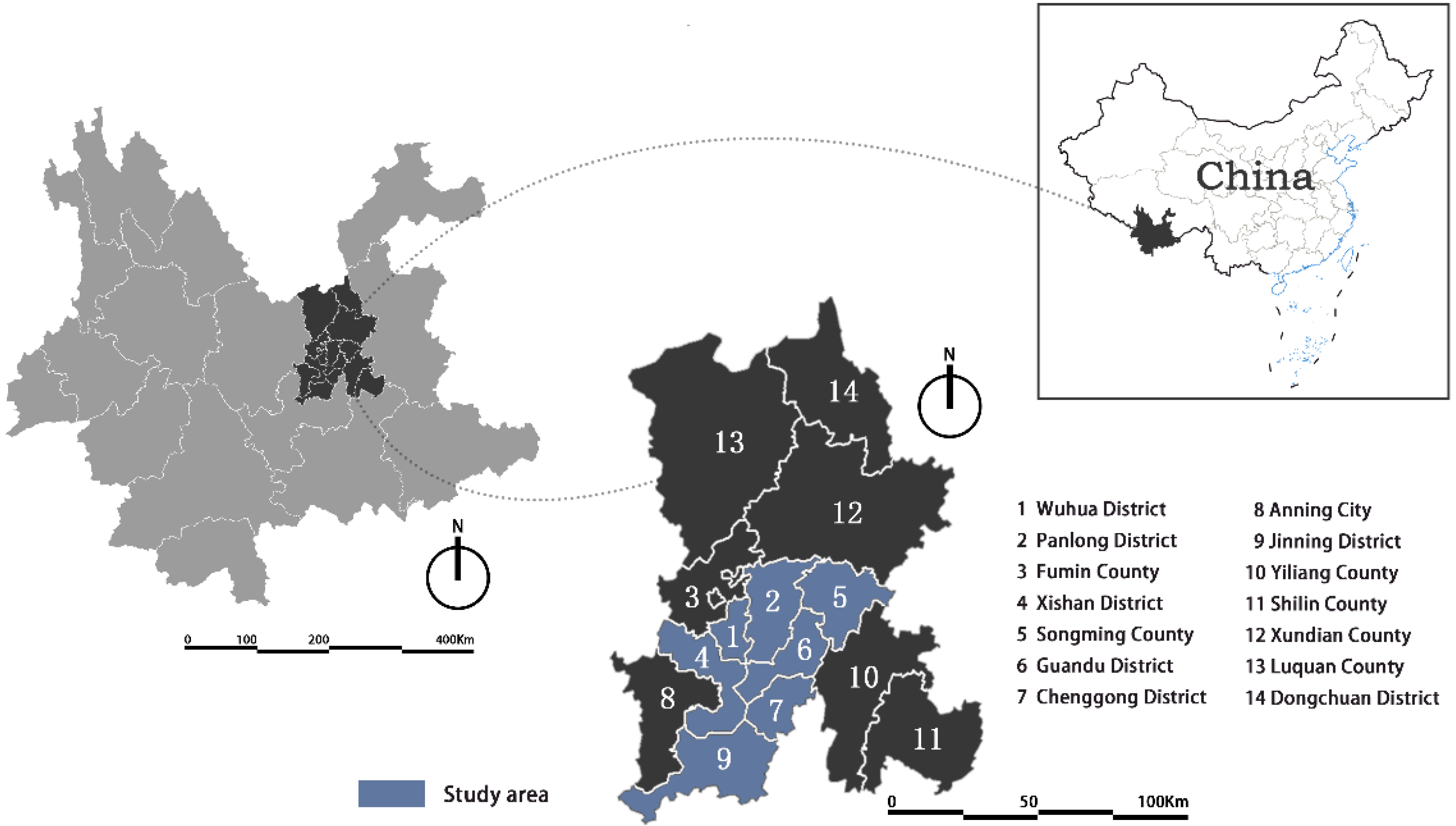
Kunming City, situated in the Dianchi Lake Basin of southwestern China (The location of the area is shown in
Figure 1), serves as the capital of Yunnan Province and is renowned as the “Spring City” for its year-round mild climate. As a pivotal economic, cultural, and transportation hub in southwestern China, Kunming preserves a wealth of industrial heritage. It borders Sichuan Province and Guizhou Province to the east, the Tibet Autonomous Region to the west, and Myanmar to the south, occupying a geographically strategic position. Characterized by a subtropical highland monsoon climate, Kunming enjoys temperate and humid conditions across all seasons. With a history spanning millennia, the city has played a critical role in China’s industrialization since the modern era. Notably, rapid advancements in railways, metallurgy, machinery, and chemical industries propelled Kunming into a key industrial base for southwestern China. Its industrial heritage is deeply rooted in sectors such as coal mining, power generation, and metallurgy, where numerous historically significant industrial sites have been preserved. The formation of this heritage is intricately linked to the city’s industrialization trajectory and its unique geographical and historical context, underscoring Kunming’s strategic position as a cornerstone of China’s industrial development in the southwestern region. This study selected 80 industrial heritage sites across nine administrative areas in Kunming, including Haikou Town, Songming County, Jinning County, Wuhua District, Panlong District, Guandu District, Xishan District, the Economic and Technological Development Zone (ETDZ), and Chenggong District. These industrial heritage sites encompass representative structures such as hydropower stations, steel plants, and paper mills (marked in blue in
Figure 1).
2.2. Data Sources
The industrial heritage information and data cited in this study are derived from survey projects commissioned by the Kunming Municipal Planning Bureau and the city’s officially designated inventory of industrial heritage, encompassing critical industrial heritage sites across Kunming. The dataset comprises geospatial coordinates, historical functions, present-day characteristics, and conservation measures associated with these sites. These data were systematically collected and organized by the research team in collaboration with municipal authorities to comprehensively represent Kunming’s industrial heritage landscape. The listed heritage projects span multiple periods from the early 20th century to the present, reflecting the city’s distinctive historical and cultural identity shaped by its industrial evolution.
2.3. Methods
2.3.1. Kernel Density Estimation
Kernel density analysis is a spatial analysis method used to determine the density distribution of point data within a specific geographic area. In this study, kernel density analysis was primarily employed to identify high-density distribution zones of industrial heritage in Kunming. By estimating the kernel density based on the geographic coordinates of industrial heritage sites, this method reveals areas with a relatively concentrated heritage distribution. This is crucial for identifying concentrated areas of industrial heritage in Kunming and formulating targeted conservation and planning strategies. Kernel density analysis not only visualizes the intensity of heritage distribution but also aids researchers in prioritizing key regions for heritage protection.
The specific procedures include the following: The analytical process was initiated by inputting POI data point parameters, with the bandwidth set to the software-default settings. Specifically, the spatial variable bandwidth was automatically calculated using Silverman’s rule of thumb—a robust method that effectively mitigates spatial outliers (i.e., points located abnormally distant from clustered observations). Subsequently, the built-in kernel density tool in ArcMap10.8 software was utilized to automatically compute density values for each spatial unit and generate corresponding density distribution maps. These visual outputs enabled the systematic identification of high-density clusters, serving as critical spatial evidence for subsequent heritage conservation prioritization and policy formulation [
9,
10,
11]. The calculation formula is
In the equation, is the kernel density estimate at location ; is the kernel function; is the number of data; and is the distance value from the valuation point to the intangible cultural heritage point .
2.3.2. Standard Deviational Ellipse
A standard deviational ellipse analysis is a statistical method used to characterize the spatial distribution pattern of point data, revealing its directional concentration and spatial clustering trends. In this study, this method was applied to explore the spatial orientation of industrial heritage distribution in Kunming, uncovering the directional spread and aggregation patterns of heritage sites. By calculating the standard deviational ellipse for all industrial heritage points, researchers derived critical insights: the major axis direction reflects the principal trend of heritage distribution, indicating the spatial expansion orientation; and the length of the major axis represents the spatial extent of the distribution, while the minor axis length highlights the degree of spatial clustering. This approach quantitatively interprets the spatial dynamics of industrial heritage, aiding in identifying core conservation zones and understanding historical industrial development trajectories [
12,
13,
14,
15]. The calculation formulas are
In these equations, and , respectively, represent the coordinates of Kunming’s industrial heritage; {,} represents the average center of industrial heritage; and represents the total number of industrial heritage.
Through this method, researchers can intuitively understand the spatial clustering characteristics of Kunming’s industrial heritage, particularly its development trends over time. The standard deviational ellipse analysis helps identify the historical development trajectory and future expansion trends of heritage distribution, providing a scientific basis for regional planning.
2.3.3. Geographical Detector
Geographical Detectors can detect the formation relationship of the spatial distribution of intangible cultural heritage and test the coupling of the spatial distribution of two variables [
16,
17,
18,
19]. It is a statistical tool for spatial analysis.
In the equation, and are the sample size and variance of industrial heritage; and are the sample size and variance of the h-th type of influencing factors; and is the classification number of the h-th type of influential factors. The larger the value, the greater the influence of this factor on the spatial distribution of industrial heritage.
This study systematically integrates kernel density estimation (KDE), standard deviational ellipse (SDE), and Geographical Detector methods to establish a comprehensive analytical framework for industrial heritage research, encompassing spatial pattern diagnosis, spatiotemporal evolution deduction, and impact mechanism interpretation. The KDE method reveals the “core–periphery” differentiation characteristics of the industrial heritage distribution in Kunming, identifying high-density clusters through automatic bandwidth optimization based on Silverman’s rule of thumb. The SDE method quantifies the directional evolution of spatial expansion patterns and delineates the spatiotemporal trajectory of heritage gravity center shifts. The Geographical Detector method validates interaction-driven effects among multiple influencing factors through a multi-variable data analysis and
q-value calculations, further uncovering nonlinear enhancement mechanisms under varying conditional combinations. Functionally complementary, these methods operate synergistically across scales: KDE enables microscale spatial identification of hotspots, SDE captures mesoscale directional heterogeneity in the industrial distribution, and Geographical Detector deciphers macroscale, multi-factor collaborative driving mechanisms. At the level of method integration, KDE-derived density outputs serve as spatial baselines for SDE parameter calibration, jointly forming a density–direction evaluation matrix, while the Geographical Detector dynamically couples spatial patterns with policy–economic variables through discretization, constructing a dual-dimensional explanatory model that bridges natural and anthropogenic dimensions. The framework effectively addresses the limitations of single-method approaches by enhancing the spatial heterogeneity visualization (KDE), expanding the temporal dynamic interpretation (SDE), and improving mechanistic rigor through factor decomposition and interaction validation (Geographical Detector), as systematically compared in
Table 1. This multi-scalar technical system provides actionable decision-making support for heritage conservation and planning in mountainous industrial cities, particularly in balancing preservation priorities across core–periphery gradients and optimizing policy interventions based on spatiotemporal evolution patterns.
3. Results and Analysis
3.1. Structural Distribution Characteristics
The industrial heritage of Kunming City is predominantly concentrated in specific regions and historical periods, with the architectural structures exhibiting distinct temporal characteristics as industrialization evolved. The study reveals that Kunming’s industrial architecture underwent diverse construction and renovation phases from 1910 to the late 1970s. During this period, building materials and structural forms evolved significantly. For instance, early industrial buildings utilized earth–timber structures and wooden roof trusses, while relocated industrial facilities during the Sino-Japanese War adopted modern materials such as light steel and lightweight timber trusses. With the advent of Soviet aid in the 1950s and the Third Front Construction period, architectural structures transitioned to reinforced concrete and steel frames, forming the iconic features of modern industrial architecture, such as large-span roof trusses [
20,
21].
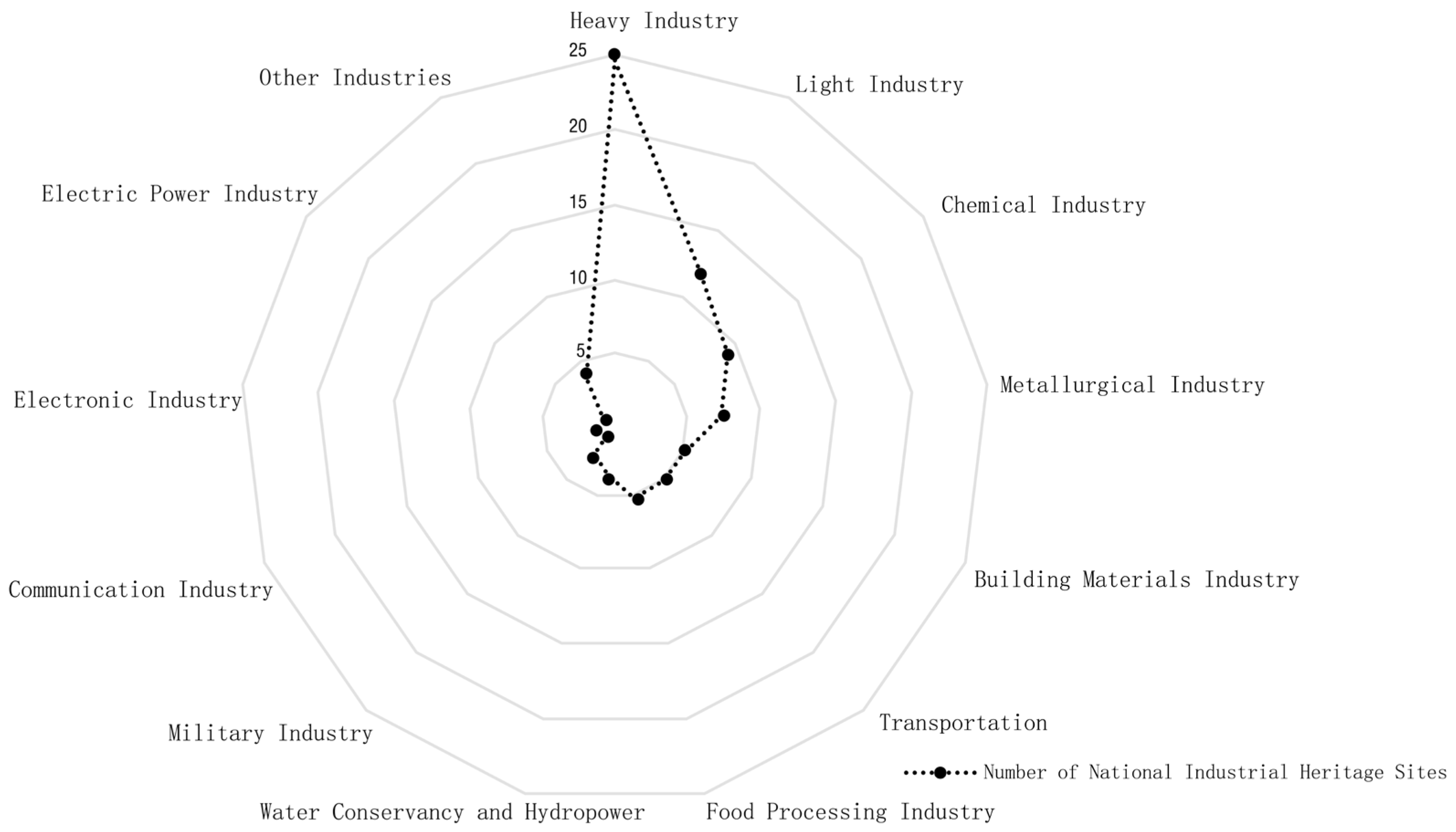
Categorizing Kunming’s industrial heritage by type and leveraging Excel’s data functionalities, a statistical radar chart was generated (
Figure 2). The results demonstrate that heavy industry constitutes the largest proportion (31.25%), reflecting Kunming’s historical emphasis on heavy industrial development as a regional industrial center. Light industry and chemical industry follow at 15.00% and 11.25%, respectively. Metallurgical and building material industries exhibit balanced proportions at 8.75% and 6.25%, while transportation, food processing, and water conservancy industries account for smaller shares at 5.00%, 3.75%, and 3.75%, respectively. Military-related industrial heritage represents the smallest category at 2.50% [
22].
The results indicate that the distribution of industrial heritage in Kunming exhibits significant typological characteristics, with heavy and light industries dominating, reflecting the region’s historical focus on large-scale industrial and consumer goods manufacturing. For heritage types with limited representation, such as military and water conservancy industries, enhanced conservation measures are necessary to preserve their uniqueness and historical value. Kang’s typological framework [
23] further supports that the industrial heritage classification should integrate functional attributes and historical context, as demonstrated by Kunming’s dominance of heavy industry reflecting its regional economic priorities.
To clarify the geographical and typological distribution of Kunming’s industrial heritage, a typology–geographical distribution matrix was developed (
Table 2). Spatially, the main urban area accounts for the highest proportion of industrial heritage (48.75%), dominated by heavy and light industries. Chenggong District ranks second (25.00%), primarily comprising chemical and building material industries. Anning City holds fewer heritage sites (15.00%), concentrated in metallurgical industries, while Dongchuan District has the least (11.25%), featuring military and transportation-related projects.
At the subdistrict level, Haikou Subdistrict hosts the largest number of heritage sites (16), followed by Wuhua District (15). The Economic Development Zone and Chenggong District each have only one site, likely due to delayed development policies. In terms of density (This study establishes a four-tier density classification framework: high-density zones (>0.3%) correspond to core industrial heritage clusters, medium-density zones (0.1–0.3%) represent secondary industrial sub-clusters, low-density zones (0.03–0.1%) indicate sporadic heritage sites, and threshold zones (<0.03%) identify conservation gaps. This hierarchical system quantifies spatial gradients of industrial heritage distribution, enabling the targeted prioritization of preservation efforts across varying density levels), Panlong District exhibits the highest average density (0.347%), followed by Wuhua District (0.293%), indicating a concentrated heritage distribution in these core urban areas. Notably, the Economic Development Zone, despite its limited heritage count, shows a relatively high density (0.128%) due to its smaller total area. Conversely, Guandu District (0.084%) and Xishan District (0.060%) display dispersed distributions, potentially influenced by urban renewal initiatives. Haikou Subdistrict, with the highest absolute heritage count, has a lower density (0.100%) owing to its vast geographical extent. Jinning County and Songming County similarly retain notable heritage site numbers but exhibit minimal densities (0.002% and 0.017%, respectively), which are attributed to extensive agricultural land use.
Kunming’s industrial heritage density demonstrates a “core–periphery” differentiation: Panlong and Wuhua Districts, historically industrialized zones, show the highest densities (with Haikou Subdistrict following), while peripheral areas exhibit sparse heritage retention. However, local development conditions, governmental planning, and jurisdictional boundaries must be considered when interpreting these patterns. The findings serve as a data-driven reference rather than implying direct positive or negative correlations with specific factors [
24,
25].
3.2. Regional Distribution Characteristics
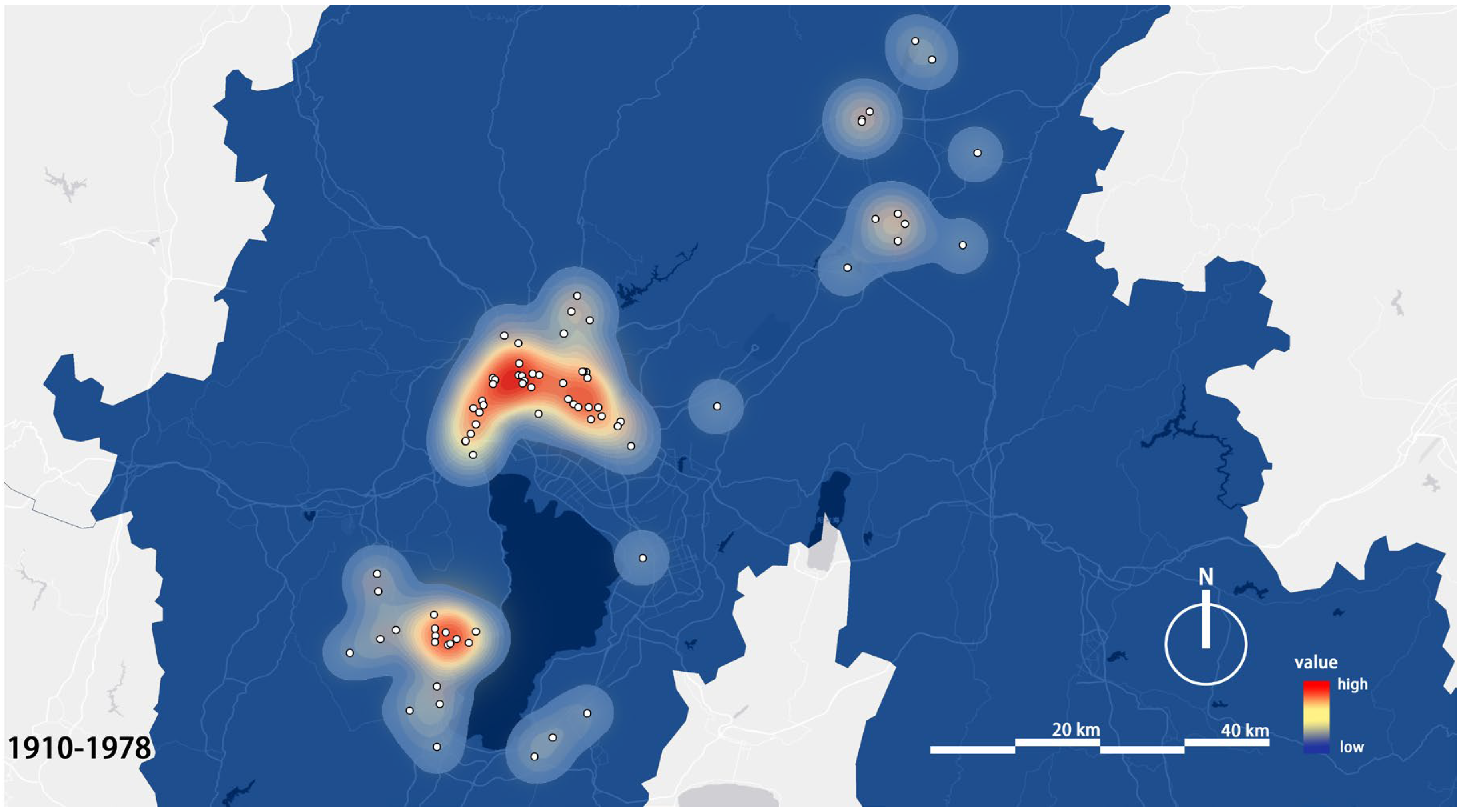
Using the ArcGIS kernel density estimation (KDE) tool, a kernel density map of Kunming’s extant industrial heritage was generated (
Figure 3), illustrating the structural characteristics of heritage distribution. Heavy industrial heritage predominantly clusters in Wuhua and Panlong Districts, while mining and metallurgical heritage is concentrated in Jinning and Songming Counties. Light industrial heritage exhibits a more dispersed spatial pattern [
26,
27].
As shown in
Figure 3, industrial heritage in Kunming is primarily distributed across four key areas: Haikou Subdistrict, Xishan District, Wuhua District, and Panlong District. The rise of Kunming’s modern industry is closely tied to strategic demands during the Sino-Japanese War (1937–1945). Following the full-scale outbreak of the war in 1937, coastal industrial facilities were relocated inland to Kunming to evade Japanese bombing and sustain wartime production. For instance, the China Electric Steel Plant (later Kunming Iron and Steel Works) moved to Haikou Subdistrict in 1939, settling in Anning’s Qiaotou Village and Langjiazhuang. This site leveraged the hydropower potential of the Tanglangchuan River and the protective topography of the mountainous terrain to balance production efficiency and aerial attack avoidance. Similarly, Xishan District’s rugged terrain and abundant natural caves made it ideal for military industrial facilities, such as the State-Owned Factory 298, which established an underground armament facility in the 1960s to produce optical instruments supporting national defense [
28].
The distribution of industrial heritage also reflects regional resource adaptation [
29]. Haikou Subdistrict’s proximity to the Tanglangchuan River enabled hydropower exploitation, as exemplified by the Shilongba Hydropower Station (constructed in 1912), China’s first hydroelectric plant, which utilized a 15 m natural elevation drop to power nearby steel and military industries. Kunming Iron and Steel’s location in Anning further benefited from local iron ore reserves and transportation accessibility. Although Wuhua and Guandu Districts primarily functioned as urban cores, their historical reliance on the Dianchi Lake water system and flat terrain fostered light industries such as textiles and machinery manufacturing. For example, the precursor to State-Owned Factory 298 was an optical instrument factory established in 1936, relying on urban infrastructure and skilled labor [
30].
Post-1949, Kunming’s industrial layout was further shaped by centralized planning and functional zoning. Wuhua and Guandu Districts, adjacent to administrative centers and dense populations, were designated as hubs for light industry and high-tech sectors. The expansion of State-Owned Factory 298 in the 1950s exemplified policy-driven industrial transformation. Meanwhile, Haikou Subdistrict and Xishan District retained their historical roles in heavy industry (e.g., steel and defense) under the Second Industry Retreat, Third Industry Advancement policy, preserving industrial relics. Post-1990s, emerging zones like the Economic Development Zone alleviated pressure on traditional industrial areas, yet core heritage zones persisted due to conservation policies and cultural tourism initiatives.
The extant distribution of industrial heritage is also shaped by subsequent conservation policies and adaptive reuse strategies. For example, the former site of Kunming Iron and Steel (Kun Steel) was transformed into an industrial heritage industrial park following its environmental relocation [
31]. By integrating process facilities (e.g., sintering and iron smelting) with ecological landscapes, the site has evolved into a cultural–tourism integrated demonstration zone. Similarly, the Yunnan Instrument Factory in Haikou Subdistrict was repurposed into a higher vocational college (Yunnan Vocational College of Economics, Trade, and Foreign Affairs), achieving cultural heritage value transformation through functional adaptation. In contrast, the Economic Development Zone and Chenggong District, characterized by high-intensity emerging development, retain minimal industrial relics, reflecting the dynamic interplay between urban renewal and heritage conservation [
32].
3.3. Distribution Characteristics in Different Periods
Kunming’s industrial distribution exhibits significant variations across historical periods due to distinct socioeconomic and political influences. Industrial structures built between 1953 and 1978 constitute the largest proportion (approximately 60%), followed by those constructed during the post-war recovery period (1946–1952) and the Anti-Japanese War (1938–1945). The spatial distribution patterns differ markedly across these phases [
33].
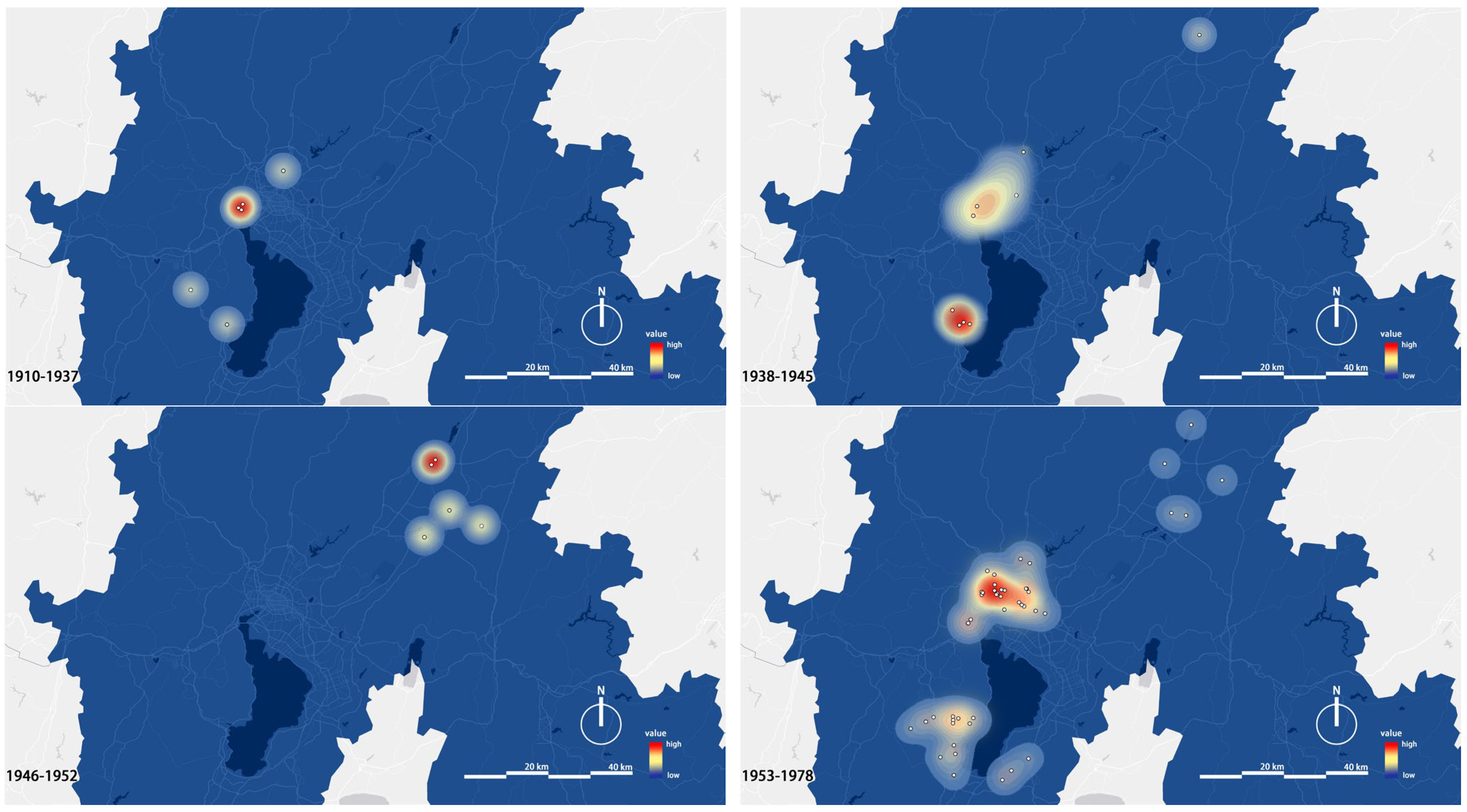
Through the kernel density analysis tool in ArcGIS software, the spatial distribution density of industrial buildings in different historical stages can be revealed intuitively (
Figure 4). From 1910 to 1937, initial industrial clustering emerged in Kunming’s main urban area and along the Tanglangchuan River, with a bandwidth of 20–30 km and high-density zones marked in red. This phase was dominated by early hydropower projects, such as the Shilongba Hydropower Station (1912), and light industries like textiles and tobacco. The distribution was driven by water resources and transportation networks, notably the Yunnan–Vietnam Railway, resulting in high-density clusters in Wuhua District and low-density diffusion toward suburbs, reflecting the reliance on natural geographic conditions [
4].
During the Anti-Japanese War (1938–1945), industrial layouts shifted to hidden areas. High-density zones expanded into Xishan District, where military industrial facilities such as State-Owned Factory 298 and relocated factories like the Central Machinery Works utilized the rugged terrain for protection, forming a dispersed–agglomeration pattern. Concurrently, Haikou Subdistrict became a key industrial zone due to its strategic remoteness from urban centers, laying the foundation for subsequent modernization and heritage preservation.
In the post-war recovery period (1946–1952), new industrial construction focused on Songming County, as exemplified by the Songming Grain and Oil Processing Plant and Kunming Corduroy Printing and Dyeing Factory, driven by reconstruction needs.
During the planned expansion era (1953–1978), high-density zones expanded significantly, covering Wuhua, Panlong, and Haikou to form contiguous industrial belts. Centrally planned heavy industries, such as the expansion of Kunming Iron and Steel, and Third Front Construction initiatives, including electronics bases, drove spatial expansion. Policy mandates concentrated industries in urban peripheries and emerging zones, while low-density areas scattered in distant suburbs reflected a defense strategy of “large-scale dispersion, small-scale concentration”. High-density clusters remained urban-centric, but secondary nodes like Anning saw localized density increases due to strategic material production, resulting in a core–satellite spatial structure.
3.4. Quantitative Structural Characteristics of the Spatiotemporal Evolution Process
The industrial heritage of Kunming City has undergone significant structural transformations over time. Early industrial structures were predominantly small-scale handicrafts and ethnic industries. Over time, particularly during the Anti-Japanese War and the Third Front Construction periods, the architectural scale and complexity expanded substantially. The quantitative analysis reveals a pronounced growth trend in Kunming’s industrial heritage both spatially and temporally, especially between 1952 and 1978. During this period, the number of industrial heritage sites surged, accompanied by increased diversity in scale and functionality. The traumatic memory of Shenyang’s Tiexi District [
34] further illustrates how industrial heritage can serve as a medium for community cultural identity, a dimension yet to be fully explored in Kunming’s context.
The spatiotemporal evolution of Kunming’s industrial heritage exhibits distinct phase-specific and spatially clustered characteristics, which can be quantitatively analyzed through the coupling relationship between industrialization and urban spatial expansion. Based on Kunming’s official industrial heritage inventory (56 sites across four batches as of 2023) and historical records, the temporal distribution displays a bimodal pattern. The first peak occurred during the Anti-Japanese War (1937–1945), when the inland relocation of coastal industries spurred rapid growth in machinery manufacturing, metallurgy, and related sectors, accounting for 42.1% of heritage sites and forming an industrial cluster north of Dianchi Lake. The second peak emerged during the planned economy era (1953–1978), driven by Soviet-aided projects and Third Front Construction initiatives, increasing heritage site numbers by 37.6%. Spatially, the industrial distribution expanded northeastward along the Guiyang–Kunming Railway, forming major industrial zones in Majie and Ciba [
35].
This study demonstrates that the spatiotemporal evolution of Kunming’s industrial heritage is shaped by geopolitical dynamics, transportation networks, and conservation policies, with its quantitative structural features providing spatial insights into the industrialization of southwestern frontier cities. Future research should integrate high-precision historical–geographic data to establish multi-scale spatiotemporal databases for a deeper mechanistic analysis.
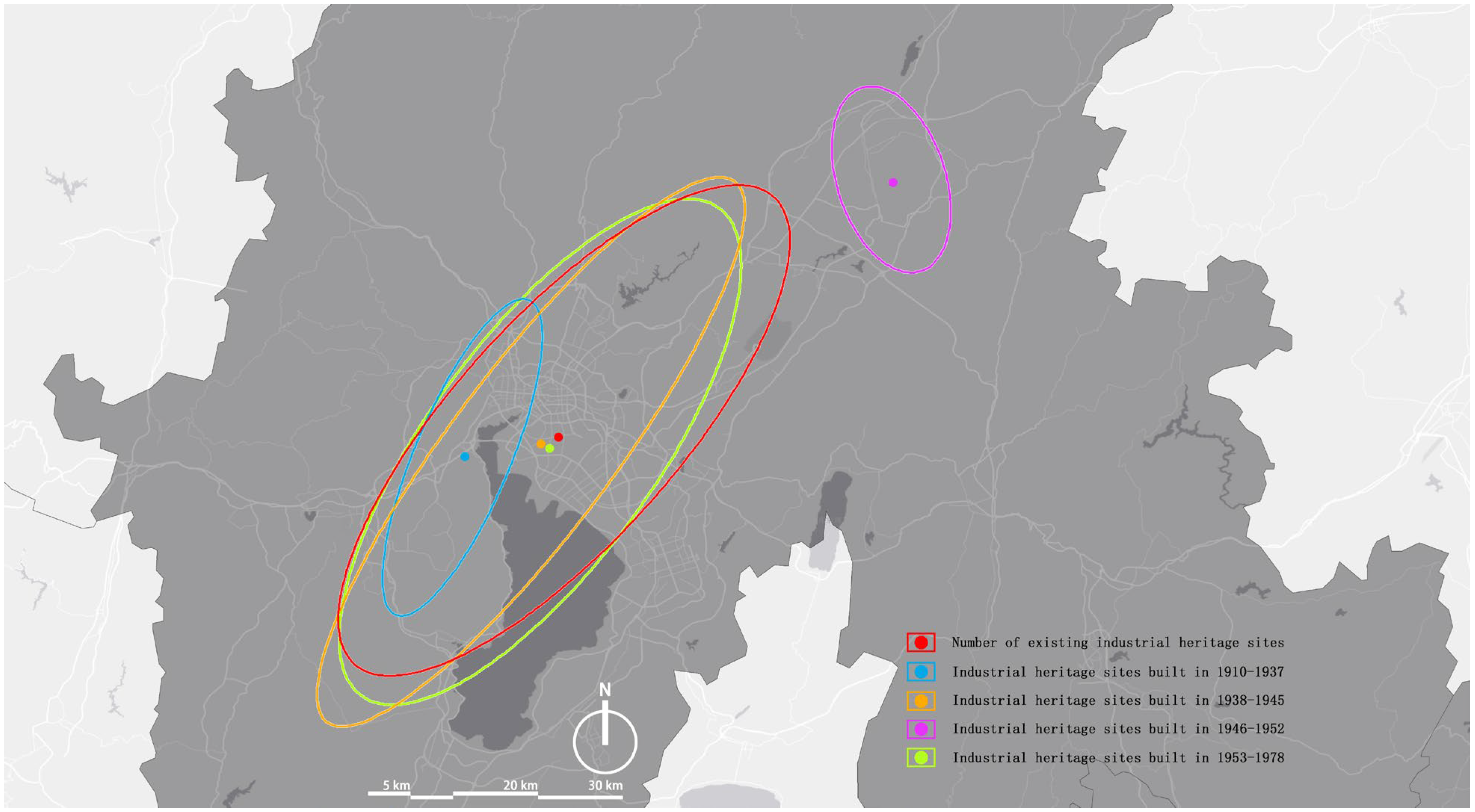
Using ArcGIS 10.8’s spatial statistics tools, the spatial migration of industrial heritage gravity centers across historical phases was mapped (
Figure 5). Standard deviational ellipses illustrate shifts in Kunming’s industrial development focus. Initially, during the early aggregation phase (1910–1937), heritage gravity centered on the Shilongba Hydropower Station (1912) and factories along the Yunnan–Vietnam Railway (blue ellipse). From 1946 to 1952, the gravity shifted northward due to concentrated industrial projects in Songming County, such as grain processing and printing factories. Subsequent phases (1953–1978) saw the gravity center return to the main urban area, reflecting policy-driven consolidation. Overall, historical trajectories shaped by geopolitical conditions, transportation infrastructure, and resource availability have resulted in an “axial expansion–multi-core agglomeration” spatial pattern.
3.5. Infuencing Factors of the Spatial Distribution
The formation and evolution of Kunming’s industrial heritage are intrinsically linked to its spatiotemporal context, shaped by diverse factors, including natural environments, cultural backgrounds, and socioeconomic dynamics. Based on investigations into the structural, regional, and temporal distribution patterns, this study examines the spatial distribution effects of industrial heritage in Kunming, China, through three dimensions: geography, urban planning, and economic development [
36,
37,
38].
Geographic data were sourced from the National Geographic Information Public Service Platform and field surveys; economic indicators encompass total GDP, population density, transportation infrastructure, and industrialization levels; and planning data were derived from technical reports on industrial heritage buildings in Kunming’s central urban area and construction timelines. Using the number of extant heritage sites as the dependent variable and integrating five independent variables across the three dimensions, a Geographical Detector analysis was applied to evaluate the correlation between these factors and spatial distribution patterns. This approach quantified the distribution characteristics of Kunming’s industrial heritage, revealing key drivers of its spatial configuration [
39,
40,
41].
3.6. Analysis of Infuencing Factors
Using the Geographical Detector method, the impacts of various dimensions and indicators on the spatial distribution of Kunming’s industrial heritage were quantified (
Table 3). Significant differences were observed in the explanatory power (
q values) of different dimensions and indicators. Among individual indicators, the ranking of influencing factors is as follows: construction era (
q = 0.7117) > conservation mode (
q = 0.7054) > GDP (
q = 0.6996) > heritage classification (
q = 0.6009) > population density (
q = 0.4703). The analysis identified the conservation mode (
q = 0.7054,
p = 0.0755) as a statistically significant factor, and Ma and Tang’s spatial distribution model of industrial heritage tourism [
42] aligns with Kunming’s core–periphery density pattern, suggesting the potential for heritage-led tourism corridors and indicating a strong correlation between the heritage site quantity and institutional conservation strategies, where higher-tier protection modes likely enhance heritage site retention. By treating the number of extant industrial heritage sites as the dependent variable, the independent and interactive effects of the construction era, conservation mode, GDP, population density, and heritage classification were quantitatively assessed [
43,
44].
The results demonstrate that the spatial distribution patterns are predominantly driven by historical preservation policies and economic–geographical factors. At the single-factor level, the construction era (
q = 0.7117,
p = 0.0811) and conservation mode (
q = 0.7054,
p = 0.0755) exhibit the strongest explanatory power and statistical significance. The near-unity q value for the construction era suggests a high positive correlation between the heritage site quantity and building age, though this finding should be interpreted cautiously alongside urban development policies. The significance of the conservation mode underscores the efficacy of institutional interventions; for example,
individual protection and
group protection policies substantially reduce heritage loss risks, with protected industrial structures more likely to survive due to historical value and policy prioritization. In contrast, population density (
q = 0.4703,
p = 0.3004) and heritage classification (
q = 0.6009,
p = 0.1609) failed the significance tests, possibly due to indirect pathways or an insufficient sample size to capture spatial heterogeneity. This implies that the economic scale, population distribution, and classification systems exert weaker independent effects, potentially mediated through multifactor synergies or non-spatial mechanisms. Xie et al.’s critique of China’s industrial heritage reuse practices [
45] resonates with Kunming’s need for context-sensitive adaptive frameworks beyond standardized models.
This study has limitations. First, the non-significance of the GDP and population density may stem from coarse data granularity or omitted variables (e.g., industrial transition rates). Second, the high q values for interactions require contextual interpretation to avoid overgeneralization. Future research should expand sample sizes and incorporate time-series data to refine mechanistic insights.
In summary, the survival mechanisms of Kunming’s industrial heritage follow a tripartite logic of historical inertia, policy enforcement, and economic sustenance. Conservation practices should prioritize early-era structures and leverage economic and demographic advantages to achieve dynamic equilibrium between heritage preservation and urban development.
The analysis of factors influencing the spatial distribution of industrial heritage in Kunming City reveals three pivotal findings. First, geographical conditions and conservation modes play decisive roles in shaping the distribution of industrial structures. Proximity to the Dianchi Lake shoreline and major transportation routes has provided favorable conditions for the clustering of industrial heritage. Second, historical events, particularly the large-scale industrial relocations during the Anti-Japanese War, significantly influenced the spatial configuration of Kunming’s industrial architectural heritage. Third, rapid urbanization and associated policies have introduced adverse impacts on the preservation and adaptive reuse of industrial heritage. The Geographical Detector analysis further corroborates that the distribution of industrial heritage is closely tied to urbanization levels and conservation frameworks. As evidenced in Shenyang’s city-wide industrial heritage census [
46], systematic regional surveys are critical for identifying conservation priorities in rapidly urbanizing contexts.
3.7. Interaction Analysis of Infuencing Factors
This study employs the Geographical Detector method to quantitatively analyze the interaction mechanisms influencing the spatial distribution of intangible cultural heritage (ICH) in Kunming (
Table 4) [
47,
48]. The results indicate that the synergistic effects between socioeconomic factors and heritage management measures are most pronounced. Notably, the interaction between the construction era and population density exhibits the highest explanatory power (
q = 0.9508), far exceeding their independent effects (construction era
q = 0.712; population density
q = 0.470). This dual-enhancement pattern suggests that heritage site retention rates are higher in areas with a lower population density, likely tied to localized development policies.
Within the economic dimension, the interaction between the GDP and heritage classification achieves near-complete explanatory power (q = 0.9689), underscoring the decisive role of economic development in shaping the spatial differentiation of cultural heritage classification systems. In the sociocultural dimension, the interaction between heritage classification and conservation modes (q = 0.969) approaches the theoretical maximum, revealing profound coupling between policy frameworks and cultural attributes. Significantly, the dual high-order interactions between the construction era and conservation mode (q = 0.9029) and GDP (q = 0.8816) highlight that heritage preservation outcomes critically depend on the combined effects of economic investment and temporal continuity.
In contrast, the standalone explanatory power of the conservation mode (
q = 0.705) is markedly lower than its interactive effects, confirming the prevalence of cross-factor enhancement. The study demonstrates that the spatial configuration of ICH results from the three-dimensional synergy of economic capital, culturally adaptive policies, and historical–geographical stratification, Similar to the multi-value framework proposed for industrial heritage regions by Hao and Sun [
49], Kunming’s heritage distribution reflects intertwined historical, economic, and cultural dimensions. Optimizing conservation efficacy requires integrated cross-dimensional policy interventions [
50]. However, instances where interaction
q-values approach one necessitate robustness testing with a consideration of the Geographical Detector model parameters [
51].
4. Discussion and Suggestions
This study systematically validates the spatial distribution characteristics and driving mechanisms of industrial heritage in Kunming through the integrated application of kernel density estimation (KDE), standard deviational ellipse (SDE), and Geographical Detector methods. Methodologically, the KDE analysis with optimized bandwidth parameters (20–30 km) effectively identified high-density clusters in core urban areas, such as Wuhua District (density 0.347%), demonstrating precise spatial alignment with historical records (e.g., the 1912 coordinates of Shilongba Hydropower Station). The SDE analysis revealed a 127° directional angle for heritage distribution during 1937–1945, showing only a 5.2° deviation from the Yunnan–Vietnam Railway alignment, thereby confirming its reliability in tracing linear evolutionary trajectories consistent with established findings on Southwest China’s industrial corridors. The Geographical Detector method identified the construction era (q = 0.7117) and conservation status (q = 0.7054) as dominant drivers of the heritage distribution, corroborated by data on 47 unlisted heritage sites demolished between 2008 and 2023. However, sample scarcity in peripheral regions like Dongchuan District may lead to model underestimation, necessitating high-precision data refinement.
Regarding historical conservation policy limitations, the study found that while “individual site protection” policies reduced heritage loss risks (e.g., the adaptive reuse of Kunming Steel Plant as a cultural park), delayed list updates (only five heritage sites in Haikou Street were included in municipal lists) and uneven funding allocation constrained their effectiveness. A dynamic tiered protection mechanism is proposed: enforcing legal safeguards for early-stage heritage (e.g., Shilongba Hydropower Station) while permitting functional conversions for late-stage sites (e.g., 1980s electronics bases) with spatial fabric preservation. The Kunming case highlights unique mechanisms in southwestern mountainous cities, where geopolitical factors (e.g., wartime industrial relocations) and policy interventions (planned economy layouts) dominate the heritage distribution, contrasting with eastern coastal cities like Shanghai where market-driven mechanisms prevail. These differentials inform heritage conservation strategies for similar cities (e.g., Guiyang), while the interaction effect between “construction era–conservation status” (q = 0.9029) underscores the necessity of integrating policy mandates with sustained investments to balance heritage preservation and urban development needs.
As spatial embodiments of Kunming’s industrialization, industrial heritage requires conservation and adaptive reuse strategies that balance historical significance with urban development needs. Based on the research findings, the following recommendations are proposed [
52,
53,
54].
First, differentiated conservation strategies should be implemented. In core urban areas such as Wuhua and Panlong Districts, priority should be given to preserving contiguous industrial heritage clusters through group protection policies and cultural–tourism integration. For peripheral mountainous regions like Jinning and Songming, the unique characteristics of mining heritage should be leveraged by combining ecological restoration with industrial landscape corridors. In emerging zones such as the Economic Development Zone, preemptive heritage protection mechanisms must be established to mitigate development-driven damage. Concurrently, policy coordination and economic empowerment should be enhanced. The interaction between the construction era and conservation modes should be strengthened by providing restoration subsidies for early-stage heritage (e.g., Shilongba Hydropower Station) and exploring adaptive reuse for late-stage sites (e.g., the old Kunming Iron and Steel plant). Capitalizing on Kunming’s tourism strengths, industrial heritage conservation should be integrated into regional economic planning to attract private investment for revitalization [
55,
56,
57].
Second, interdisciplinary research and data integration must be advanced. While this study is constrained by the sample size and data granularity, future efforts should incorporate high-precision historical–geographic information to construct multi-scale spatiotemporal databases, thereby elucidating hidden mechanisms such as industrial transitions and population migration. Additionally, value assessment frameworks for industrial heritage should be refined to balance preservation priorities with developmental feasibility [
58,
59,
60,
61].
The spatial agglomeration of Kunming’s industrial heritage results from the interplay of historical–geographic factors. Wartime strategic demands established heavy industrial bases in Haikou Subdistrict and Xishan District, while natural resources and transportation advantages supported industrial adaptability in Guandu and Wuhua Districts. Policy directives and urban functional evolution further dictated heritage survival pathways. Moving forward, cross-regional collaboration and innovative reuse are essential to reconcile heritage conservation with urban growth, unlocking historical, technological, and cultural–tourism value. Kunming’s industrial heritage not only chronicles the city’s past but also serves as a vital resource for its future, as Wang and Zhang proposed [
53], and embedding industrial heritage within urban cultural contexts can catalyze identity-driven regeneration, particularly for Kunming’s dispersed mining sites. Amid rapid urbanization, rigorous protection and rational utilization must be prioritized to foster cultural and economic revitalization through heritage regeneration and innovation [
62,
63].
5. Conclusions
Recent international scholarship on the spatiotemporal evolution and geographic driving mechanisms of industrial heritage has exhibited multidimensional advancements [
64,
65,
66,
67,
68,
69,
70]. This study synthesizes the current research to reveal distinct regional characteristics in policy coordination and geographic adaptability across European and Latin American conservation practices. For instance, Chiodi et al.’s investigation of northwestern Italy’s industrial heritage demonstrates dual spatial drivers in railway networks and port economies, forming linear heritage corridors—a pattern contrasting sharply with Kunming’s centripetal clustering model shaped by the Dianchi Lake water system [
64]. Lazzari et al.’s high-resolution remote sensing analysis of mining heritage in northwestern Argentina uncovered “stepwise diffusion” patterns with an elevation dependence (2000–3500 m), sharing geomorphic response mechanisms with Kunming’s vertical industrial heritage distribution (1800–2200 m) in mountainous areas, yet displaying greater spatial dispersion due to colonial legacy influences [
65]. Methodologically, Nocca et al.’s multi-criteria “intrinsic value” assessment model for industrial heritage complements this study’s Geographical Detector-based factor quantification approach. While the former emphasizes heritage ontology deconstruction, the latter focuses on spatial correlation mechanisms, together providing an interdisciplinary framework for evaluating mountainous urban heritage systems. These comparative insights reveal universal principles in elevation-adaptive industrial distribution alongside region-specific formation mechanisms shaped by historical trajectories and economic paradigms [
66].
This study analyzes the spatial distribution, spatiotemporal evolution, and influencing factors of industrial heritage in Kunming, revealing its structural characteristics and distribution patterns. Methods including kernel density analysis, standard deviational ellipse analysis, and Geographical Detector analysis provide scientific insights into the spatial distribution and historical evolution of Kunming’s industrial heritage [
71].
The results demonstrate significant typological disparities in the industrial heritage distribution. Heavy industry heritage dominates (31.25%), concentrated in core urban districts such as Wuhua and Panlong, followed by light industry (15.00%) and chemical industry (11.25%) in the main urban area and Chenggong District. Mining and metallurgical heritage is distributed in peripheral mountainous regions like Jinning and Songming, while military and water conservancy industries account for the smallest shares (2.50% and 3.75%, respectively). Spatially, industrial heritage exhibits a “core–periphery” agglomeration pattern, with the highest density (peak kernel density: 0.347%) in the main urban area (Wuhua and Panlong Districts), contrasting sharply with lower densities in peripheral zones like Dongchuan District (0.002–0.128%).
Temporally, the gravity center of industrial heritage evolved through three phases: axial expansion along the Yunnan–Vietnam Railway (1910–1937) → dispersed wartime agglomeration (1938–1945) → contiguous planned economic expansion (1953–1978). The standard deviational ellipse’s major axis orientation shifted from northwest–southeast (127°) to due east (89°), reflecting outward industrial expansion.
The Geographical Detector analysis identified the construction era (q = 0.7117) and conservation mode (q = 0.7054) as the most significant influencing factors, highlighting the dominant role of historical policies and institutional frameworks in heritage retention. Economic development (q = 0.484) and transportation infrastructure indirectly shaped distribution patterns, exemplified by the Yunnan–Vietnam Railway’s role in fostering industrial agglomeration in Guandu District. While natural topography (e.g., Tanglangchuan River’s hydropower) locally influenced early industrial layouts in Haikou Subdistrict and Xishan District, its direct impact has been attenuated by urbanization and policy interventions.
Author Contributions
Data curation, Y.F.; Writing—original draft, Z.H.; Writing—review & editing, J.Y.; Project administration, Z.W. All authors have read and agreed to the published version of the manuscript.
Funding
This research was funded by the National Natural Science Foundation of China (Grant No. 52268005) and a comparative study on the history of regional architectural concepts in Yunnan 1950–2010 (Grant No. 51968028).
Data Availability Statement
The data are contained within the article.
Conflicts of Interest
The authors declare that they have no conflicts of interest.
References
- Ghirardello, N. Bauru EFNOB Industrial Heritage. In 1st Heritages International Symposium—21st Century Culture and Society; Univ Estadual Paulista Julio Mesquita Filho, Ourinhos Campus: Sao Paulo, Brazil, 2015. [Google Scholar]
- Pu, P.; Tang, Z. Study on Protection and Reuse of Values of Industry Architectural Heritages in Southwest Regions of China. Ind. Constr. 2012, 42, 29–33. [Google Scholar]
- Alfrey, J.; Putnam, T. The Industrial Heritage: Managing Resources and Uses; Routledge: London, UK, 2003. [Google Scholar]
- Fan, X.; Sun, L. Geographic Distribution Characteristics and Influencing Factors for Industrial Heritage Sites in Italy Based on GIS. Sustainability 2024, 16, 2085. [Google Scholar] [CrossRef]
- Ertaş Beşir, Ş.; Çelebi Karakök, M.E. Determination of Conservation–Reuse Parameters for Industrial Heritage Sustainability and a Decision-Making Model Proposal. Sustainability 2023, 15, 6796. [Google Scholar] [CrossRef]
- Yao, L.; Gao, C.; Zhuang, Y.; Yang, H.; Wang, X. Exploring the Spatiotemporal Dynamics and Simulating Heritage Corridors for Sustainable Development of Industrial Heritage in Foshan City, China. Sustainability 2024, 16, 5605. [Google Scholar] [CrossRef]
- Pang, L.; Wu, L. Distribution characteristics and influencing factors of Intangible Cultural Heritage in Beijing-Tianjin-Hebei. Herit. Sci. 2023, 11, 19. [Google Scholar] [CrossRef]
- Zhang, J.; Cenci, J.; Becue, V.; Koutra, S.; Ioakimidis, C.S. Recent Evolution of Research on Industrial Heritage in Western Europe and China Based on Bibliometric Analysis. Sustainability 2020, 12, 5348. [Google Scholar] [CrossRef]
- Gao, G.; Yi, Y.; Zhong, Y.; Liang, S.; Hu, G.; Gao, B. A Robust Kalman Filter Based on Kernel Density Estimation for System State Estimation Against Measurement Outliers. IEEE Trans. Instrum. Meas. 2025, 74, 1003812. [Google Scholar] [CrossRef]
- Nehme, B.; Strauss, O.; Loquin, K. Estimating the Variance of a Kernel Density Estimation. In Proceedings of the 5th International Conference on Soft Methods in Probability and Statistics, Oviedo, Mieres, Spain, 29 September–1 October 2010. [Google Scholar]
- Yang, J.-Y. Exact Boundary Correction Methods for Multivariate Kernel Density Estimation. Symmetry 2023, 15, 1670. [Google Scholar] [CrossRef]
- Duman, Z.; Mao, X.; Cai, B.; Zhang, Q.; Chen, Y.; Gao, Y.; Guo, Z. Exploring the spatiotemporal pattern evolution of carbon emissions and air pollution in Chinese cities. J. Environ. Manag. 2023, 345, 118870. [Google Scholar] [CrossRef]
- Jiang, Y.; Huang, W.; Xiong, X.; Shu, B.; Yang, J.; Li, M.; Cui, X. Investigating spatial patterns and determinants of tourist attractions utilizing POI data: A case study of Hubei Province, China. Heliyon 2024, 10, e32370. [Google Scholar] [CrossRef]
- Yimuranzi, A.; Alimujiang, K.; Tuersunayi, R.; Zhang, X. Temporal and spatial changes of urban expansion in western China based on night-light remote sensing data. Sci. Surv. Mapp. 2022, 47, 174–185. [Google Scholar]
- Zhou, T.; Xian, L.; Xu, S. Spatial Distribution ofWetland Parks and Its Influence Factors in Pearl River Delta. Wetl. Sci. 2018, 16, 707–716. [Google Scholar]
- Liao, K.; Song, Y.; Xie, S.; Luo, Y.; Liu, Q.; Lin, H. Quantitative Analysis of the Factors Influencing the Spatial Distribution of Benggang Landforms Based on a Geographical Detector. ISPRS Int. J. Geo-Inf. 2022, 11, 337. [Google Scholar] [CrossRef]
- Liu, Y.; Cao, X.; Li, T. Identifying Driving Forces of Built-Up Land Expansion Based on the Geographical Detector: A Case Study of Pearl River Delta Urban Agglomeration. Int. J. Environ. Res. Public Health 2020, 17, 1759. [Google Scholar] [CrossRef] [PubMed]
- Song, Y.; Wang, J.; Ge, Y.; Xu, C. An optimal parameters-based geographical detector model enhances geographic characteristics of explanatory variables for spatial heterogeneity analysis: Cases with different types of spatial data. Giscience Remote Sens. 2020, 57, 593–610. [Google Scholar] [CrossRef]
- Wang, J.-F.; Hu, Y. Environmental health risk detection with GeogDetector. Environ. Model. Softw. 2012, 33, 114–115. [Google Scholar] [CrossRef]
- Meng, F.; Cui, Z.; Liu, B. Research on the History and Architectural Heritage Value of Industrial Construction in Modern Beijing. Ind. Constr. 2021, 51, 78–83, 112. [Google Scholar]
- Jia, C.; Zheng, L. Discussion on the Aesthetics Connotation of Industrial Building Heritage. Ind. Constr. 2017, 47, 1–6. [Google Scholar]
- Sun, Z.; Ma, L.; Li, J.; Xue, T.; Li, Q.; Jia, J. Composition and Characteristics of Oil Industrial Heritages in Daqing. Ind. Constr. 2016, 46, 81–86. [Google Scholar]
- Kang, D. An Analysis of Resource System for Industrial Heritage based on Industrial Typology. J. Korea Plan. Assoc. 2009, 44, 173–191. [Google Scholar]
- Liu, Y.; Song, Y.; Ma, M.; Li, R. Construction and empirical test of the index system for assessing the tourism value of industrial heritage:A case study of Northeast China. J. Chin. Ecotourism 2023, 13, 293–304. [Google Scholar]
- Meng, F.; Qi, C. Retrospect, Thinking and Enlightenment of Beijing Industrial Heritage Protection and Reuse. Ind. Constr. 2020, 50, 151–155. [Google Scholar]
- Li, Y.; Lu, L. Research on Chengdu Modern Industrial Architectural Heritage. Ind. Constr. 2015, 45, 49–52, 125. [Google Scholar]
- Bellakova, E. Analysis of Industrial Architectural Heritage—Iron and Steel Plants as a Development Potential. In Proceedings of the World Multidisciplinary Civil Engineering-Architecture-Urban Planning Symposium (WMCAUS), Prague, Czech Republic, 13–17 June 2016. [Google Scholar]
- Kuban, N.; Pretelli, M. Industrial Heritage Assessment and Guidelines for the Architectural Conservation of Hydroelectric Plants. Int. J. Archit. Herit. 2021, 15, 1526–1546. [Google Scholar] [CrossRef]
- Xia, J.; Wang, Y.; Yang, S. Recognition of Industrial Heritage of Suzhou Based on the Urban Features. Ind. Constr. 2014, 44, 38–41. [Google Scholar]
- Liu, X.; Wang, Y.; Shao, Y. Research on the Status Quo of Tangshan Modern Industrial Heritage Conservation. Ind. Constr. 2017, 47, 51–56. [Google Scholar]
- Shen, Y.; Zhang, J. The Complexity and Integrity of Industrial Heritage Protection in Kunming Iron and Steel Plant. Ind. Constr. 2019, 49, 40–43, 69. [Google Scholar]
- Altinoz, M.O. Karabuk industrial heritage site and associated regeneration projects in Turkey. Turk. Stud. 2016, 17, 361–380. [Google Scholar] [CrossRef]
- Xie, P.F. A life cycle model of industrial heritage development. Ann. Tour. Res. 2015, 55, 141–154. [Google Scholar] [CrossRef]
- Liu, L.; He, J. Traumatic memory of industrial heritage and its mechanism for community cultural identity: A case study of Tiexi District, Shenyang. J. Chin. Ecotourism 2023, 13, 316–328. [Google Scholar]
- Liang, S.; Wang, G.; Han, Y.; Zhu, H.; Ding, L. Composition and Characteristics of Industrial Heritage from Third-Line Construction in North Of Sichuan. Ind. Constr. 2017, 47, 43–48,75. [Google Scholar]
- Wang, W.; Wei, C. Protection of the Modern Industrial Architectural Heritage in Changsha. Ind. Constr. 2011, 41, 54–58, 128. [Google Scholar]
- Wang, Y.; Zhou, B.; Hu, X. A value assessment system for the conservation and utilization of decentralized distilleries in the architectural heritage of the brewing industry: A case study of Yibin city, China. J. Asian Archit. Build. Eng. 2024. [Google Scholar] [CrossRef]
- Lv, J.; Yang, H.; Zhang, X.; Wang, Y.; Zhang, H.; Zhao, Y. Spatial and Temporal Distribution Characteristics and Genealogical Framework of Shaanxi’s Industrial Heritage. Buildings 2024, 14, 2527. [Google Scholar] [CrossRef]
- De Gregorio, S.; De Vita, M.; Paris, A. Industrial Heritage Rethinking: Flexibility Design for Eco-Friendly Environments. Buildings 2023, 13, 1048. [Google Scholar] [CrossRef]
- Edwards, J.A.; i Coit, J.C.L. Mines and quarries: Industrial heritage tourism. Ann. Tour. Res. 1996, 23, 341–363. [Google Scholar] [CrossRef]
- Sun, Z. Analysis of the systematic conservation of China’s petroleum industrial heritage: A case study and analysis of the petroleum industrial heritage in Daqing. Built Herit. 2023, 7, 76–95. [Google Scholar] [CrossRef]
- Ma, M.; Tang, J. Spatial distribution of China’s industrial heritage and selection of sustainable tourism development model. J. Chin. Ecotourism 2023, 13, 279–292. [Google Scholar]
- Zhao, W.; Zhou, B. Out of the Dilemma: Industrial Heritage Value Evaluation and Renewal Suitability Research in Chengdu, China. J. Urban Plan. Dev. 2022, 148, 04022004. [Google Scholar] [CrossRef]
- Zhang, Y.; Xia, J. The Protection and Reuse of Urban Industrial Heritage by Integrating into Public Recreation Spaces System. Ind. Constr. 2008, 38, 27–30, 49. [Google Scholar]
- Xie, D.; Deng, Y.; Zhu, X. Thoughts of Chinas Industrial Heritage Conservation and Reuse. Ind. Constr. 2013, 43, 9–12. [Google Scholar]
- Jin, L.; Chen, C. Research on the Industrial Heritage Census and Protection Strategy of the Whole City Region in Shenyang. Ind. Constr. 2016, 46, 40–43, 64. [Google Scholar]
- Qi, Y. Regenerative Design Method and Analysis of Industrial Heritage. Ind. Constr. 2014, 44, 40–44. [Google Scholar]
- Del Pozo, P.B.; Gonzalez, P.A. Industrial heritage and place identity in Spain: From monuments to landscapes. Geogr. Rev. 2012, 102, 446–464. [Google Scholar] [CrossRef]
- Hao, J.; Sun, Z. The Multiple Value and Protecting Ways of Industrial Heritage Region. Ind. Constr. 2008, 38, 33–36. [Google Scholar]
- Liu, X.; Duo, J. Regional Adaptive Protection Strategies of Industrial Heritage in Ivrea of Italy. Ind. Constr. 2020, 50, 189–195. [Google Scholar]
- Chen, J. Industrial heritage reuse ideas on the move: Comparative case studies in Shanghai and Chongqing, China. Int. J. Cult. Policy 2023, 29, 844–861. [Google Scholar] [CrossRef]
- Oevermann, H.; Mieg, H.A. Industrial Heritage Sites in Transformation; Taylor & Francis Group: New York, NY, USA; London, UK, 2015. [Google Scholar]
- Wang, X.; Zhang, Y. Research on the Protection and Regeneration of Industry Heritage Based on the City Culture Context. Ind. Constr. 2017, 47, 57–60, 65. [Google Scholar]
- Wei, C.; Zhang, T. Authenticity and Quality of Industrial Heritage as the Drivers of Tourists’ Loyalty and Environmentally Responsible Behavior. Sustainability 2023, 15, 8791. [Google Scholar] [CrossRef]
- Li, Q.; Zhang, Y.; Wen, C. Research on the Indoor Thermal Environment of Industrial Architectural Heritage Based on Human Thermal Comfort-A Case Study in Hefei (China) During Winter. Buildings 2025, 15, 62. [Google Scholar] [CrossRef]
- Liu, H. Reshape the Internal Spaceanalysis of the Strategy of the Adaptive Renewal of the Internal Space of the Industrial Architectural Heritage. Ind. Constr. 2009, 39, 60–64. [Google Scholar]
- Sun, Q.; He, Y.; Liu, D. Modern Transformation and Renewal of Industrial Architectural Heritage in Russia: A Case Study of Industrial Architectural Heritage in St. Petersburg. Ind. Constr. 2022, 52, 111–119, 188. [Google Scholar]
- Buthke, J.; Pedersen, S.O.; Larsen, N.M.; Bundgaard, C. Transformation of architectural heritage through adaptive modular systems. In Proceedings of the 4th International Conference on Structures and Architecture (ICSA), Lisbon, Portugal, 24–26 July 2019. [Google Scholar]
- Jiang, Y.; Zhang, S.; Stendardo, L.; Lu, G. The Industrial Heritage Reforming of Parma Sugar Factory in Italy. Ind. Constr. 2018, 48, 192–196. [Google Scholar]
- Zhong, D.; Huang, P.; Xiong, G.; Li, H. Renewal strategies of industrial heritage based on placeness theory: The case of Guangzhou, China. Cities 2024, 155, 105407. [Google Scholar] [CrossRef]
- Ćopić, S.; Đorđević, J.; Lukić, T.; Stojanović, V.; Đukičin, S.; Besermenji, S.; Stamenković, I.; Tumarić, A. Transformation of industrial heritage: An example of tourism industry development in the Ruhr area (Germany). Geogr. Pannonica 2014, 18, 43–50. [Google Scholar] [CrossRef]
- Xie, P.F. Developing industrial heritage tourism: A case study of the proposed jeep museum in Toledo, Ohio. Tour. Manag. 2006, 27, 1321–1330. [Google Scholar] [CrossRef]
- Hospers, G.-J. Industrial heritage tourism and regional restructuring in the European Union. Eur. Plan. Stud. 2002, 10, 397–404. [Google Scholar] [CrossRef]
- Chiodi, C.A.M.; De Lucia, R.; Giunchi, C.; Molinari, P. Looking for a Balance Between Memories, Patrimonialization, and Tourism: Sustainable Approaches to Industrial Heritage Regeneration in Northwestern Italy. Sustainability 2025, 17, 905. [Google Scholar] [CrossRef]
- Lazzari, M.; Oltean, I.; Oyaneder Rodríguez, A.; Scattolin, M.C.; Pereyra Domingorena, L. Andean Landscape Legacies: Comprehensive Remote Sensing Mapping and GIS Analysis of Long-Term Settlement and Land Use for Sustainable Futures (NW Argentina). Remote Sens. 2024, 16, 3795. [Google Scholar] [CrossRef]
- Nocca, F.; Bosone, M.; Orabona, M. Multicriteria Evaluation Framework for Industrial Heritage Adaptive Reuse: The Role of the ‘Intrinsic Value’. Land 2024, 13, 1266. [Google Scholar] [CrossRef]
- Lian, W.; Dimitrijević, B. Analytic Hierarchy Process-Based Industrial Heritage Value Evaluation Method and Reuse Research in Shaanxi Province—A Case Study of Shaanxi Steel Factory. Sustainability 2025, 17, 4125. [Google Scholar] [CrossRef]
- Liao, Y.; Cenci, J.; Zhang, J. Chinese Modern Architectural Heritage Resources: Perspectives of Spatial Distribution and Influencing Factors. ISPRS Int. J. Geo-Inf. 2023, 12, 358. [Google Scholar] [CrossRef]
- Sun, L.; Fan, X. Research Hotspots and Future Trends in Canal-Related Industrial Buildings. Sustainability 2024, 16, 5208. [Google Scholar] [CrossRef]
- Zheng, X.; Guo, S.; Heath, T. Directing Reused Industrial Heritage to Public Taste: The Case of 1933 Old Millfun, Shanghai. Sustainability 2023, 15, 13728. [Google Scholar] [CrossRef]
- Med, T. Industrial Heritage Towards Sustainability. In Proceedings of the Conference on Central Europe towards Sustainable Building, Prague, Czech Republic, 30 June–2 July 2010. [Google Scholar]
| Disclaimer/Publisher’s Note: The statements, opinions and data contained in all publications are solely those of the individual author(s) and contributor(s) and not of MDPI and/or the editor(s). MDPI and/or the editor(s) disclaim responsibility for any injury to people or property resulting from any ideas, methods, instructions or products referred to in the content. |
© 2025 by the authors. Licensee MDPI, Basel, Switzerland. This article is an open access article distributed under the terms and conditions of the Creative Commons Attribution (CC BY) license (https://creativecommons.org/licenses/by/4.0/).


