Article

Study on Spatial Distribution and Heritage Corridor Network of Traditional Settlements in Ancient Huizhou

1
Gold Mantis School of Architecture, Soochow University, RenAi Road, Suzhou 215134, China
2
China-Portugal Belt and Road Joint Laboratory on Cultural Heritage Conservation Science, RenAi Road, Suzhou 215134, China
3
Jiangsu Province “14th Five-Year Plan” International Cooperation Joint Laboratory for University, RenAi Road, Suzhou 215134, China
*
Author to whom correspondence should be addressed.
Buildings 2025, 15(10), 1641; https://doi.org/10.3390/buildings15101641
Submission received: 1 April 2025 / Revised: 8 May 2025 / Accepted: 9 May 2025 / Published: 13 May 2025
(This article belongs to the Topic Sustainable Built Environment, 2nd Volume)

Abstract

:
Traditional settlements are vital carriers of Chinese agricultural civilization yet face mounting challenges in protection and inheritance amid rapid urbanization. Taking ancient Huizhou as a case study, this research analyzes the spatial distribution patterns of cross-provincial traditional settlements and constructs a multi-level heritage corridor network through circuit theory modeling and space syntax analysis. The study reveals a “small aggregation, large dispersion” spatial structure shaped by natural geography and socio-cultural dynamics. Simulation of multi-path cultural flows and network analysis show that high betweenness corridors concentrate along the northeast–southwest axis, promoting efficient cultural circulation, while low betweenness areas highlight gaps in direct connectivity. Closeness analysis identifies She County as the cultural core with a single-center radial structure, though internal fragmentation persists. Based on these findings, the study proposes a “three-core-driven, two-axis linkage, multi-source synergy” protection strategy to strengthens the spatial integrity and resilience of the heritage network. This research not only provides a systematic framework for the holistic conservation of Huizhou settlement heritage but also offers methodological references for the protection of traditional settlements in broader regions.

1. Introduction

Traditional settlements are ancient towns and villages with a significant past that retain distinct historical and cultural characteristics. They carry the people’s production and way of life together with the ancient agrarian culture. They are the largest and most widely distributed cultural heritage system [1]. They are not only the basic unit of traditional social organization, but also an important window for understanding local culture. At the same time, traditional settlements have a distinct sense of place and certain regional traits [2]. However, in the process of increasing urbanization, problems such as rural population loss, economic recession, and cultural heritage disruption are becoming increasingly prominent [3,4].
To address these issues, UNESCO introduced the “HUL” concept in 2011, highlighting the need to safeguard cultural assets in a broader environmental and social context rather than just isolated individual buildings [5]. Regions such as Europe and North America rarely mention traditional settlements but treat cities and towns as historical and cultural heritage. The promulgation of the Venice Charter in 1964 was a milestone, marking a major transformation of the international cultural heritage protection paradigm. Since then, the introduction of documents such as the “Resolution on the Protection of Historic Small Towns” and the “Tlaxcala Declaration on the Regeneration of Small Settlements” has further promoted the development of regional protection practices [6]. They have established a relatively complete historical town protection system, and through legislation, the scope of protection has been expanded from single buildings to the overall environment, and the scope of research and protection has been extended from individuals to the overall environment, and from cities to rural landscapes [7]. This reflects the international trend of shifting from static protection to dynamic and holistic protection.
In China, traditional settlements not only carry historical memories, but also give birth to a rich and diverse social and cultural system. However, factors such as the modernization process, administrative division adjustments, and uneven regional development have had a serious impact on traditional settlements. According to statistics, the number of natural villages in China fell dramatically from 3.86 million to 2.36 million between 1985 and 2021, and traditional settlements are experiencing systemic crises such as empty nests, landscape homogeneity, and ecological destruction [8,9]. In recent years, China’s traditional settlement protection policy has gradually shifted from a static approach to a dynamic approach, with an emphasis on overall regional protection. The “Notice on Carrying out Demonstration Work on the Concentrated Protection and Utilization of Traditional Villages” issued in 2023 officially promoted the transformation of China’s urban and rural settlement protection from single point protection to regional surface protection, emphasizing the coordination of cultural heritage protection and development on a larger spatial scale [10]. Currently, the concept of cultural heritage protection is experiencing significant transformation. The heritage of a single element is the primary focus of the traditional protection model, but it is now gradually shifting to a comprehensive protection model that places greater emphasis on the preservation of “mixed heritage” and the “cultural landscape” created by the interaction of natural and cultural elements [11,12]. Despite this, existing research has mainly focused on traditional architectural protection, settlement morphological evolution, tourism development, etc. [13,14,15]. Most current research and practice are still mainly concentrated in a single settlement or administrative unit [16,17], lacking systematic research on cross-regional and networked protection. Internationally, holistic protection across administrative boundaries has become an important trend in maintaining cultural integrity [18,19].
As a remnant of the administrative pattern of “one government and six counties” during the Ming and Qing dynasties, the traditional settlement of ancient Huizhou in China formed a cultural ecosystem in which “officials, merchants, and literati” developed synergistically in the mountainous environment at the junction of Anhui and Jiangxi [20,21]. The Huizhou area is not only famous for its unique Huizhou architecture, but also for its highly developed trade and cultural dissemination system based on a dense land and water network, which has become a typical representative of the spatial organization of traditional Chinese settlements. Existing studies mainly focus on three levels: the macro level focuses on the spatial distribution law of settlements and its natural and humanistic influences [22,23]; the meso level explores the association law between settlements such as the street system and public space [24,25]; and the micro level focuses on the internal structural characteristics of monolithic buildings [26]. However, the existing results have not yet effectively solved the problem of regional networked conservation across administrative boundaries, and even more so, they lack a holistic analysis of the cultural ecosystem. Meanwhile, the original cultural ecological linkage of the Huizhou region was destroyed during the process of administrative restructuring: after 1949, Wuyuan County under the jurisdiction of the former Huizhou Prefecture was transferred to Jiangxi Province, and Jixi County was transferred to Xuancheng City in Anhui Province This change in the administrative affiliation made the 376 traditional settlements of the same cultural area scattered in six county level administrative units in Anhui and Jiangxi Provinces. The lack of a synergistic mechanism in the existing provincial protection planning has led to outstanding problems such as inconsistent restoration standards and broken cultural lines of Huizhou-style architecture, and the urgent need to establish a holistic protection framework across administrative boundaries. In order to maximize the spatial organization structure of settlement heritage, enhance its overall protection level, and offer a new spatial integration method for regional development, this study uses the ancient Huizhou area as an example and applies circuit theory to build a traditional settlement heritage corridor network.
The following are the study’s objectives: (1) to provide an overview of the traditional settlements’ spatial distribution features in the ancient Huizhou region; (2) to construct a cross-provincial traditional settlement heritage corridor network based on circuit theory; and (3) to address the problems of inconsistent protection standards and broken cultural routes caused by administrative divisions in the Huizhou cultural ecology, a collaborative protection framework is proposed to connect scattered heritage nodes through cross-provincial corridors to form a systematic protection system.

2. Literature Review

2.1. Heritage Corridor Theory

The heritage corridor theory provides a new perspective on spatial integration to preserve traditional settlements. The theory originated in the United States and aims to connect multiple heritage sites with cultural value into a whole through a linear spatial structure, so that they can be closely connected in physical space. The objects of protection of heritage corridors cover a wide range, including geographical elements such as river valleys, canals, mountains, ancient post roads in the natural environment, as well as historical relics such as roads, railways, and commercial channels shaped by human activities [27]. The core value of this approach is that it breaks through the limitations of the traditional cultural heritage “island” protection mode and expands the single point-like heritage into a systematic linear network, so that the cultural resources can have a greater overall effect on the regional scale. At the same time, the heritage corridor theory emphasizes the synergistic development of culture, ecology, and socio-economics, and compared with simple cultural lines or linear cultural heritage, it emphasizes the dynamics, continuity and wholeness of heritage [28], so that cultural heritage can be protected while having the possibility of living inheritance, promoting inter-regional cultural integration and economic development.

2.2. Research Content and Practical Cases of Heritage Corridors

Suitability assessment and heritage corridor construction are the two primary facets of heritage corridor research. Scholars have attempted to use a range of quantitative techniques to assess the potential value and spatial distribution characteristics of heritage corridors in terms of suitability evaluation. For example, the AHP is often used to construct the evaluation system of heritage sites or heritage areas, to measure the spatial suitability and sustainable development potential of cultural heritage [29,30]. In addition, the Tianjin University team led by Lin Feiyang utilized the MCR model for multi-factor spatial superposition to examine the distribution of the Ming Great Wall’s intangible cultural heritage. They also optimized the design of cultural heritage corridors by integrating topography, transportation, and settlement distribution [31]. Meanwhile, Li Xiaobin and others concentrated on the Yellow River Basin’s intangible cultural distribution features, highlighting the critical role that natural surroundings play in both cultural transmission and heritage preservation [32]. To construct heritage corridors, researchers generally use spatial analysis methods based on GIS tools and combine them with quantitative methods such as the MCR model [33] and the gravity model [34] to define the core area and radiation range of the heritage corridor. Sun Ying from China researched the Donghan River Basin in Guangdong, where Lingnan culture is concentrated, and used the MCR model to integrate cultural ecological sources and construct cultural ecological corridors to enhance the overall conservation efficiency of regional cultural heritage [35]. In addition, Tao Li et al. comprehensively considered the dissemination value of cultural heritage, regional influence, spatial distribution characteristics, and natural environmental constraints, and constructed CCSPM to realize the precise delineation of the spatial scope of cultural corridors [36]. These results provide a scientific basis for the development and protection of heritage corridors and also provide a reference for the protection of various forms of cultural resources.
Successful cases of international heritage corridor protection show that many countries have achieved remarkable results in cultural landscape protection. For example, the United States has established the NHA, which provides holistic protection of historical, cultural, and natural resources through federal legislation and policy support, while combining community involvement and economic development strategies to enable heritage corridors to play an important role in cultural heritage and economic revitalization [18]. As a world cultural heritage, the historic cultural corridor of the Loire Valley in France not only connects many historical buildings and towns along the coast, but also promotes the development of the area’s tourism economy and guides local governments to formulate more sustainable cultural landscape protection plans [19]. In addition, China has also achieved many successful experiences in heritage corridor conservation. For example, the Beijing-Hangzhou Grand Canal Heritage Corridor Research Project hosted by Prof. Yu Kongjian of Peking University, which spans 1764 km and involves 18 cities, has led to the systematic integration of historical and cultural resources along the canal through a combination of ecological restoration and cultural landscape protection [37]. On the other hand, Xu Jiangang’s team from Nanjing University proposed a theoretical framework for constructing a spatial network for the protection of natural cultural heritage corridors through cultural heritage value discernment and resource integration [38]. These experiences not only provide important reference for the building of historical corridors in China but also prove the practical significance of heritage corridors in promoting the integration of regional resources and the adaptive use of heritage.

2.3. Limitations of Heritage Corridor Research and New Ideas for Traditional Settlement Protection

Although existing studies have made many advances in the evaluation of heritage corridor suitability and construction methods, there are still some limitations. Firstly, most of the research objects still focus on point-like relics or linear heritage, such as the Tea and Horse Road and the Grand Canal [39], while the systematic integration of the overall regional heritage network is relatively lacking. Second, the traditional MCR model and gravity model are usually based on a single optimal path assumption, while the formation of heritage corridors is often affected by complex spatial structures, and the calculation of a single optimal path is difficult to adapt to the multi-path propagation characteristics of cultural heritage. Thirdly, current studies rarely form a closed loop of multi-level heritage networks, which leads to the fact that there is still much room for improvement in the inter-regional connectivity and holistic protection of heritage corridors. In addition, some of the studies still take administrative divisions as boundaries, failing to give full consideration to the need for cultural heritage protection across administrative regions, resulting in certain fragmentation problems in the spatial integration of heritage protection.
Based on the above analysis, the protection and utilization of traditional settlements have become a focal point of social concern, and at the same time, an important area of cross-disciplinary research. In recent years, with the progress of science and technology, the innovative application of circuit theory in the construction of ecological corridors provides a new method for cultural heritage protection [40]. Compared with the traditional MCR model, the introduction of circuit theory makes the construction of the heritage network more comprehensive and dynamic. Its core advantage is that it can simulate the multi-path effect of spatial connectivity rather than a single shortest path connection method. This method can effectively identify high-traffic corridors and key nodes in the heritage corridor network and form a ring-shaped protection network to enhance the overall resilience of the heritage corridor network. Therefore, this research uses circuit theory to construct a traditional settlement heritage corridor network to optimize the integrity and continuity of the spatial structure and information elements between settlement heritage. In this process, the spatial layout characteristics, cultural ecological background, and accessibility of traditional settlements will be fully considered, and then a settlement heritage network system with heritage corridors as the skeleton will be constructed. Through this method, the spatial correlation between heritage can be further strengthened, and the overall conservation value of cultural resources can be enhanced. This study methodology can not only generate new ideas for the overall conservation of traditional settlements like Huizhou, but it can also be used as a reference for cultural heritage protection planning in other locations.

3. Materials and Methods

3.1. Study Area

Settlement usually refers to a residential area formed by the gathering of human beings. This study focuses on the traditional settlements in Huizhou, which refers to those settlements with a complete geographic environment, traditional architecture, and spatial structures based on the traditional culture of Huizhou. These settlements not only carry rich historical information but also embody Huizhou’s unique settlement patterns, social structures, and ecological adaptation strategies (Figure 1).
Huizhou, the ancient name of Shezhou, Xin’an, its geographical concept was formally established in the Northern Song Dynasty Xuanhe (1121), when Shezhou changed its name to Huizhou. As the Song, Yuan, Ming, and Qing dynasties continued for more than 780 years, Huizhou has always been as a stable administrative unit, and its core jurisdiction covers six counties, namely, She County, Yi County, Wuyuan County, Jixi County, Qimen County, and Xiuning County, which has formed a unique cultural and geographical community. The region not only maintains a high degree of continuity in administration but also shows a deep inner connection in terms of economy, culture, clan system, etc., which has given birth to Huizhou culture with great local characteristics. In the context of contemporary administrative restructuring, the former Huizhou Prefecture is now under the jurisdiction of three prefectural-level cities in Anhui and Jiangxi Provinces. Among them, the jurisdiction of Huangshan City in Anhui Province includes the town of Tangkou in the southern part of Huangshan District, Huizhou District, and Tunxi District, the whole territory of She County, most of Yi County, Xiuning County and Qimen County (excluding the town of Anling); Jixi County is under the jurisdiction of Xuancheng City in Anhui Province; and Wuyuan County is under the jurisdiction of Shangrao City in Jiangxi Province. Since the historical political evolution is relatively complex and the modern administrative boundaries have become stable, to ensure the operability of the research, this study uses the current administrative division system for spatial analysis (Figure 2).
To ensure the consistency of data standards and the systematic nature of the study, this study selected multiple batches of national cultural heritage settlements as research objects, covering batches 1–3 of national historical and cultural cities, batches 1–7 of Chinese historical and cultural towns and villages, and batches 1–6 of Chinese traditional villages. Eventually, a total of 376 research samples were collected, of which 346 were distributed in Anhui Province and 30 in Jiangxi Province (Table 1). These settlements not only show a certain regularity in spatial distribution but are also highly representative in terms of cultural heritage, architectural style, historical pattern, and so on, providing an adequate basis for data collection for studying the spatial evolution and heritage conservation of Huizhou’s traditional settlements.

3.2. Data Sources

The data of Huizhou traditional settlements adopted in this study are mainly from the National Tourism Administration, and the latitude and longitude coordinates of each settlement are obtained through the Baidu map coordinate picker API. All coordinate data uniformly adopts the WGS 1984 earth coordinate system to ensure the universality and spatial accuracy of the data, and at the same time, constructs a standardized geographic information database. During data processing, we systematically organized each batch of traditional settlements, classified and archived them according to information such as settlement name, batch, identification period, and longitude and latitude coordinates, and established a geographic information database based on the ArcGIS 10.8 platform to provide support for subsequent spatial analysis. Specific data sources are listed in Table 2.

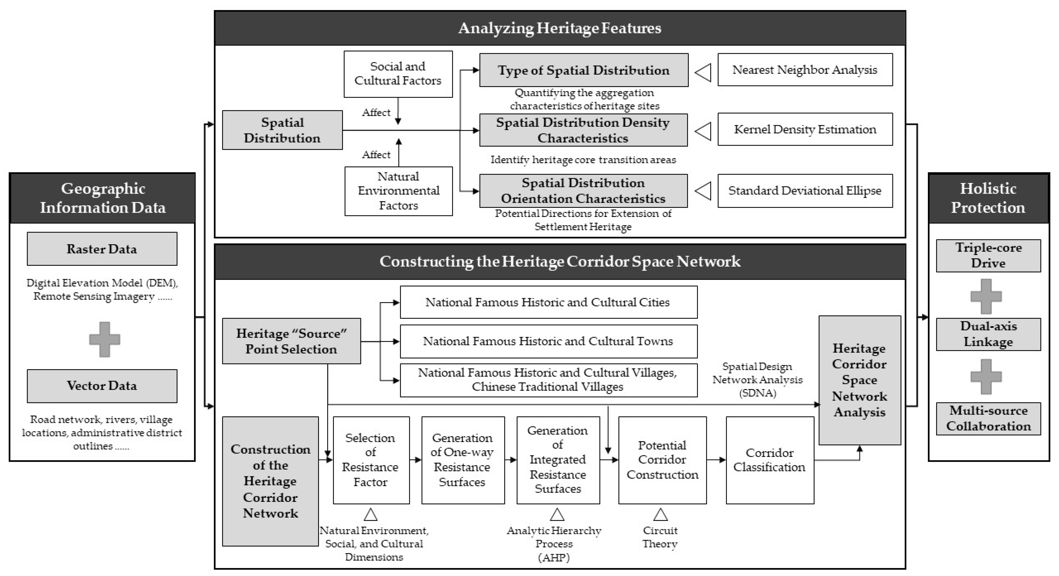
3.3. Research Framework

The heritage corridor network is a cultural heritage conservation and integration strategy that aims to emphasize the historical and cultural traits and increase its overall worth by systematic study and spatial integration of cultural heritage resources in historical cities [48]. The network consists of spatial elements such as points, lines, and surfaces, where the point element represents the cultural heritage entity, the line element constitutes the spatial bond between the heritages, and the surface element defines the overall spatial pattern of heritage protection. In this study, the traditional settlements in the ancient Huizhou area are regarded as point elements, as the core carriers of the heritage conservation network, carrying profound historical and cultural information; line elements, i.e., the constructed heritage corridors, serve as the key media connecting the dispersed heritage of the settlements to enable the isolated heritage points to form a systematic linkage network on a wider spatial scale and to enhance their overall accessibility and connectivity; and the surface elements are composed of the landscape environment around the settlements and the corridors along the route of Huizhou. The landscape environment around the Huizhou settlements and the buffer zones along the corridors together constitute the overall spatial pattern of heritage conservation, providing ecological and cultural background support for the heritage network (Figure 3).
This study investigates the traditional settlements of ancient Huizhou by analyzing their spatial distribution characteristics, overall patterns, and inter-settlement connections. A total of 376 settlements were identified using coordinate data collected from Baidu maps. Using ArcGIS 10.8, the study applies nearest neighbor analysis, kernel density estimation, and standard deviation ellipse models to examine spatial distribution types, density, and directional tendencies. A multi-factor evaluation framework is then developed, integrating natural and socio-cultural resistance factors, with weights assigned via the AHP. Circuit theory is used to construct an optimal heritage corridor network, identifying potential connection paths and enhancing spatial connectivity. To further assess the network’s structure, the sDNA model quantitatively analyzes corridor closeness and betweenness from the perspectives of topological connectivity and accessibility. Based on these findings, a holistic conservation strategy is proposed to support the systematic protection and sustainable development of Huizhou’s traditional settlements. The research framework is illustrated in Figure 4.

3.4. Research Methodology

1.
Type of Spatial Distribution: Nearest Neighbor Index
The nearest neighbor index is a geographic indicator that shows how close point objects are to one another in geographic space. It is possible to clarify the agglomeration or dispersion features of the spatial pattern by measuring the difference between the actual degree of closeness of point elements and the theoretical random distribution. By calculating the nearest neighbor index, this study uncovers the distribution type law of settlement groups by abstracting the traditional settlements in the historical Huizhou area as “particles” in a macro sense. Three modes typically sum up the spatial distribution patterns of point elements: clustered, random, and dispersed patterns [49]. The calculation formula is as follows:
R = r 1 ¯ r E = 2 r 1 D
r E = 1 2 m / A = 1 2 D
R is the ratio of the actual nearest neighbor distance to the theoretical nearest neighbor distance; r 1 ¯ represents the average distance between each point and its nearest neighbor; rE is the theoretical nearest distance when point elements are randomly distributed; m represents the number of point elements, which in this study represents the number of traditional settlement; A represents the area of the study area; and D represents the point density.
2.
Spatial Distribution Density Characteristics: Kernel Density Analysis
Kernel density analysis is a non-parametric estimation method used to analyze spatial points. It mainly estimates the density of point or line features and is used to reflect the concentration and spatial agglomeration of feature points [50]. Kernel density analysis can calculate the density of point features around each output grid, which simply shows the concentration and dispersion of traditional settlement distribution. The calculation formula is as follows:
f s = i = 1 n 1 h 2 k s c i h
f(s) represents the kernel density estimate; n is the number of traditional settlements; h (>0) is the bandwidth; the k function represents the distance relationship between each feature point s and the core ci. s-ci represents the distance between the estimated point and the event point.
3.
Spatial Distribution Orientation Characteristics: Standard Deviation Ellipse Analysis
The standard deviation ellipse is a quantitative approach for determining the range, shape, and direction of spatial element distributions. The length of the major axis denotes the degree of dispersion of the elements along the main path, while the length of the minor axis depicts the concentration intensity in the secondary direction [51]. This study examines the spatial orientation evolution law of several batches of traditional settlements using the standard deviation ellipse method. By constructing standard deviation ellipses from the first to the sixth batches of settlements, the spatial differentiation characteristics of the migration trajectory of the center of gravity of the settlement group distribution and the primary and secondary expansion directions are systematically revealed. The calculation formula is as follows:
X S D = i = 1 n x i X ¯ 2 n
Y S D = i = 1 n y i Y ¯ 2 n
XSD and YSD denote the length of the X-axis and the length of the Y-axis; xi and yi denote the coordinates of class i clusters; X ¯ and Y ¯ denote the mean center of class i cluster points; and n is the number of class i clusters.
4.
Weight Allocation of Resistance Factors: AHP
AHP is a relatively objective and quantitative multi-attribute decision-making method, which determines the weights of factors through judgment matrix and hierarchical weight calculation method and conducts comprehensive evaluation to arrive at the optimal scheme. In this paper, the factors in the resistance factor are obtained through the AHP, and the weights of the indicator layer and factor layer are obtained through the matrix algorithm; the results will be used as the basis for the construction of the heritage corridor network.
5.
Construction of Heritage Corridors: Circuit Theory
Circuit theory originates from the field of ecology. It is a spatial connectivity analysis method based on the resistance network model. It quantifies the connection resistance and potential flow probability between different spatial units by simulating the conduction path of electric current in the landscape. Its core is to abstract the geographical space into a circuit network and to analogize the flow of cultural elements to the process of electric current conduction. Natural landform barriers (such as mountains and water systems) and cultural barriers (such as traffic breakpoints) are quantified as resistance parameters, and key channels correspond to low-resistance paths [52]. This study uses this theory to construct a corridor network of ancient Huizhou traditional settlement heritage, abstracting settlements into circuit nodes, and transforming resistance factors such as terrain barriers and water system distribution into resistance parameters, which can quantify the potential resistance to communication between settlements. The calculation formula is as follows:
I = V R e f f
I denotes current, V denotes voltage, and Reff denotes the resistance of one or more conductors.
6.
sDNA
In the sDNA model, road closeness and betweenness are two core parameters. A higher closeness value suggests a greater likelihood of selecting the node as a passage in an actual trip. This metric indicates the trip cost between road segments x and y within a certain radius and is quantified using the Network Quantity Penalized by Distance (NQPDA) inside an angular radius [53]. The node closeness is calculated as follows:
N Q P D A ( x ) = y R X P ( y ) d θ ( x , y )
NQPDA(x) denotes the closeness of node x; p(y) is the weight of node y within the search radius R.
The degree of betweenness is based on the shortest path assumption and represents the maximum probability of traffic flow through a node within a certain search radius. The node betweenness degree is calculated as follows:
O D ( y , z , x ) = 1 x   lies   on   the   shortest   path   from   y   to   z 1 / 2 x y z 1 / 2 x y z 1 / 3 x y z 0 other   situations
T P B t ( x ) y N Z R y O D ( y , z , x ) P ( z ) L i n k s ( y )
TPBt(x) is node x’s betweenness degree; OD(y,z,x) is the shortest topological path between nodes y and z passing by node x within the search radius R; and Links(y) is the total number of nodes inside the search radius r from each node y.

4. Results

4.1. Characteristics of Spatial Distribution of Heritage

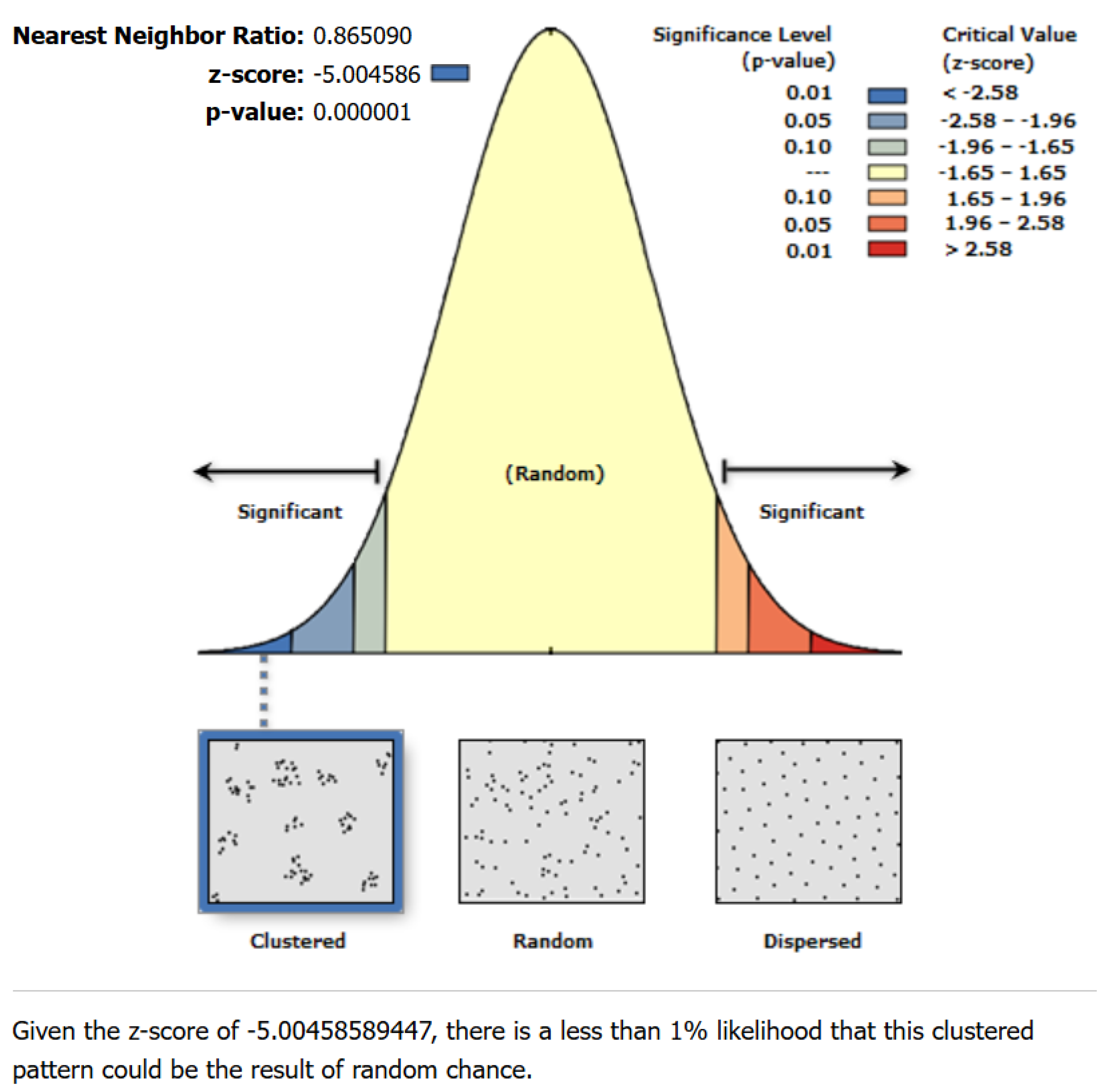
4.1.1. Type of Spatial Distribution

In this study, based on the cross-provincial spatial scale, the traditional settlements in Huizhou were abstracted into point-like elements and spatially analyzed using the ANN analysis tool of ArcGIS 10.8 software. The calculation results show that the nearest neighbor ratio of Huizhou traditional settlements is R = 0.865 (less than 1), the standardized statistical significance test value Z = −5.00 (less than −2.58), the significance level p = 0.000, and it passes the 99% confidence test. Statistical analysis shows that Huizhou traditional settlements present significant spatial cohesion characteristics, and their spatial agglomeration effect is strong (Figure 5). This phenomenon reflects that the formation of traditional settlements in Huizhou is shaped by both natural geographical conditions and socio-cultural factors, and there is an obvious geographic correlation between settlements.
This study carried out a spatial analysis at the zoning dimensions across three cities and the provinces of Anhui and Jiangxi in order to further highlight the disparities in spatial distribution. It was discovered that the spatial distribution pattern of Huizhou traditional settlements possessed clear regional differentiation characteristics using the spatial differentiation test of county units (Table 3).
The distribution of settlements in Jixi County presents clustered characteristics. Due to its topographical constraints, there is less flat land suitable for settlement development, and most settlements are concentrated in valleys, along rivers, or in mountain basins, forming a group-type settlement planform, which are mostly in the form of irregular polygons of similar size. Traditional villages of this layout form have compact land arrangement and concentrated residences, which are easy for residents to live in, and show strong closure. According to Jixi County records, group-type traditional villages accounted for more than 80% of the county’s cluster-type traditional villages [54]. The clustering effect was further reinforced by the fact that Jixi County, the beginning point of the Hui-Hang Ancient Road, has a history of regular commercial and trade interactions. Numerous clusters were developed around the old trade routes or post stations. Meanwhile, Jixi County, as one of the important birthplaces of Huizhou merchants, is influenced by the clan system, which contributed to the higher density spatial distribution.
In comparison, the traditional settlements in Huangshan District, Xiuning County, and Qimen County have a more dispersed nature that is closely connected to the regional natural environment as well as agricultural and economic trends. Although these areas are mostly hilly and mountainous, the plains and terraces suitable for human habitation are relatively dispersed and balanced, and the spatial layout of the settlements is more uniform.
The distribution of settlements in She County, Yi County, Huizhou District, Tunxi District, and Wuyuan County, on the other hand, tends to be random, which is mainly affected by multiple influences such as topographical complexity, trade and cultural factors, and modern developmental changes. The geography of these areas is complicated, with mountains, hills, and basins intermingled, and the available space for settlement construction is unequal, resulting in a lack of regularity in settlement spatial distribution. The effects of Huizhou culture and commercial development have resulted in the growth of some settlements due to the demand for trade and commerce [55], further increasing the randomness of distribution. The process of urbanization has caused some traditional villages to be transformed or incorporated into cities, further breaking the original distribution pattern. Overall, as the explicit carrier of human–land relations, the spatial distribution pattern of traditional settlements is essentially a dynamic balance between the constraints of the geographic environment and the adaptive choices of human activities.

4.1.2. Spatial Distribution Density Characteristics

This research uses ArcGIS 10.8’s kernel density analysis tool to show and analyze the spatial distribution characteristics of ancient settlements in Huizhou. The analysis results show that the study area as a whole presents a distribution pattern of “small aggregation and large dispersion”, and exhibits obvious north–south differentiation, with the density of settlements in the northern area significantly higher than that in the south, forming a “double core and multiple slices” structure with the core of She County, Huizhou, and Yi County (Figure 6a). This spatial pattern reflects the strong screening effect of natural geography and social and human factors on the development of settlements: the relatively flat terrain of the northern Huizhou basin and the stable conditions of agricultural cultivation provide a good physical basis for large-scale settlement; whereas in the southern mountainous areas, due to the fragmented topography and the scarcity of arable land, the settlements show the characteristics of a low-density, discrete distribution. In the high-density agglomeration area, She County, Huizhou District, and Yi County in Huangshan City are the areas with the most concentrated distribution of traditional settlements. She County, as the political, economic, and cultural center of ancient Huizhou, has the most traditional settlements in the study area, and the basin landscape on its territory is not only suitable for farming, but also has certain defensive advantages, prompting clan settlements to cluster along the Xin’anjiang River in a belt-like manner, forming the unique “Hundred Mile Gallery” landscape. Huizhou District (formerly under the jurisdiction of She County) is located in the core area of the mountainous basin in southern Anhui Province, with superior geographical conditions, making it a typical area of high concentration of traditional settlements. Yi County, on the other hand, relies on the closed geographical environment of the Huangshan Mountain Range, and better preserves the clusters of ancient Huizhou merchants’ settlements, such as Xidi Village and Hong Village [56,57], showing strong historical continuity and cultural inheritance characteristics.
At the county scale, Huangshan District, Huizhou District, and Yi County form a “single-core, multiple-piece” pattern, with their core areas mainly located in mountain basins and closely connected to Huizhou Prefecture through major water systems. This geographical feature provides good external conditions for Huizhou merchants’ trade and cultural exchanges and contributes to the formation of a large number of clan-aggregated villages and towns, which shows that closed landforms play an important role in the spatial organization of settlements. Concerning Tunxi County (formerly Xiuning County), as the terrain is mainly hilly, the distribution of settlements shows more scattered characteristics; undulating terrain on the concentration of settlements has an inhibitory effect. The four counties of Qimen County, She County, Xiuning County, and Wuyuan County are influenced by the mountainous and hilly terrain, forming a “dual-core single-piece” structure, which shows the role of watershed division in promoting the independent development of each region. In these hilly areas with many mountains and water, agricultural farming is still the main form of livelihood [58]. Jixi County, on the other hand, exhibits a spatial pattern of “multiple nuclei and double slices”, highlighting the dual reinforcement of basin–valley geomorphology on the development of settlement clustering (Figure 6b–j).
The spatial structure of traditional settlements is affected by a mix of elements, including topographical characteristics, agricultural production circumstances, social conditions, and policy orientations during certain historical periods. Among them, the natural geographical environment provided the basic framework of the spatial pattern, while social factors such as the clan system, commercial network, and cultural exchange further shaped the unique spatial pattern of Huizhou traditional settlements.

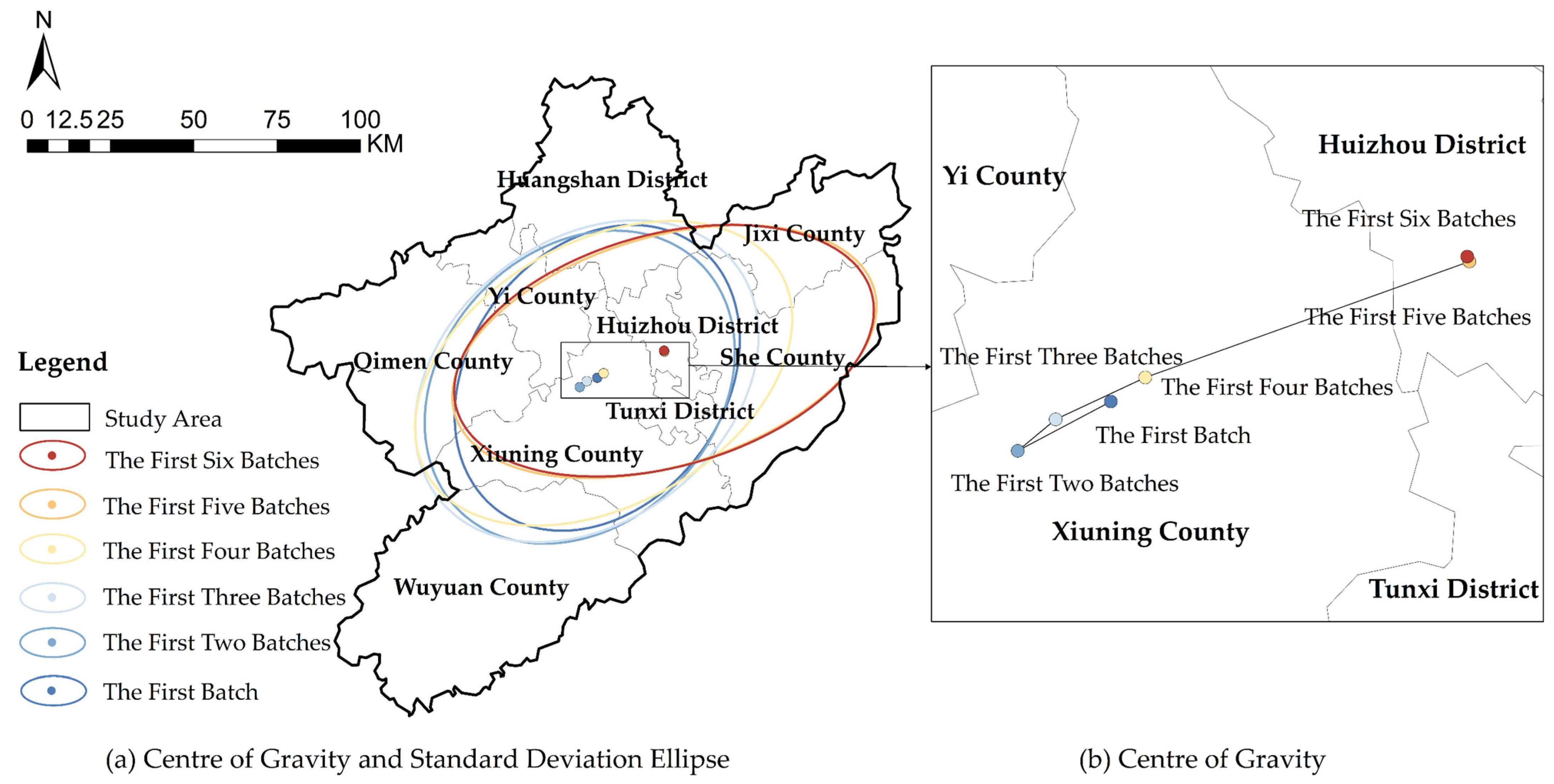
4.1.3. Spatial Distribution Orientation Characteristics

Six batches of traditional villages in the Huizhou area are the subject of this research’s spatial distribution characteristics; these batches are excluded from the analysis because of the region’s comparatively small number of historical and cultural cities and towns, as well as the wide variations in their publication dates. The spatial characteristic parameters of village distribution are calculated and extracted using the standard deviation ellipse method (Table 4). The results show that the spatial agglomeration range of traditional villages in the study area has shown significant dynamic changes. Its core distribution pattern has undergone a gradual transition from the northeast–southwest axis to the east–west direction. The migration trajectory of the spatial center of gravity shows a spatial evolution pattern similar to the “6” shape and gradually shifts from Xiuning County to the Huizhou area (Figure 7).
As the key index of spatial agglomeration, the gradual shrinkage of the standard deviation ellipse area shows that the spatial distribution pattern of traditional villages in each batch tends to disperse from concentration. Meanwhile, the measured data show that the value of oblateness in the research area continues to increase (all are greater than 0 and the increase is significant), which reveals two important spatial characteristics: first, the spatial expansion of the village cluster is mainly along the east–west axis, and the diffusion effect is increasingly enhanced; second, with the evolution of the batches, the direction of the spatial expansion is more and more clear, and the evolution of the spatial pattern of the traditional villages has a certain policy-driven feature.
The “first six batches” division adopted in the study is essentially a stage-by-stage trajectory of the implementation of the national cultural heritage protection policy, and its time series mainly reflects the changes in the intensity of the policy protection rather than the natural evolution of the traditional settlements. This artificial division means that the spatial distribution characteristics of different batches of villages may be affected by the adjustment of the selection criteria. In contrast, the dynamic change in the spatial parameters essentially reflects the interaction between the intensity of the implementation of the protection policy and the perception of the value of cultural heritage [59,60,61]. Therefore, the adjustment of the azimuth is not only the result of geographical selection but also can be regarded as the spatial projection of the tilt of national policy resources towards the core area of Huizhou culture. The changes in the distribution pattern of identified villages are not only affected by natural geographical factors such as elevation and slope but are also closely related to the intensity of human activities.

4.2. Construction of Heritage Corridor Network

4.2.1. Selection of Resistance Factors

Previous research has demonstrated that the natural environment, as well as factors from culture and society, influence the spatial distribution of traditional settlements. Different environmental conditions have varying degrees of effect on spatial accessibility, influencing the viability of heritage corridors. In the research region, the lower the resistance value, the better the corridor is for construction and for linking and integrating cultural heritage. To scientifically identify the key factors affecting the connectivity of heritage corridors, this study, based on the summary of the research results of relevant scholars (Table 5), and using the frequency statistics method and combining the specific conditions of the ancient Huizhou area, seven key resistance factors were selected, covering the two dimensions of natural geography and social culture, including elevation, slope, land use type, distance from rivers, distance from main roads, distance from residential areas, and night light index. These factors comprehensively reflect the impact of terrain characteristics, ecological environment, and social factors on the accessibility of heritage corridors, laying the foundation for the construction of resistance surfaces.
In terms of the natural environment, the complexity of topography and geomorphology has a direct impact on the expansion of space for human activities and has influenced the location of traditional settlements in Huizhou in the process of long-term evolution. The Huizhou region is characterized by a spatial pattern of “mountains surrounded by water and basins nested”, with mountain ranges acting as natural barriers to construct a relatively closed geographical environment, while water systems assume the function of connecting the region and forming natural linear channels; the many mountain basins provide small habitats suitable for people to live together [65]. In terms of spatial mechanisms, elevation and slope change regional accessibility by affecting traveling costs, while land use types have differentiated impacts on accessibility depending on the nature of the land cover. In addition, the distribution of water systems in Huizhou was decisive for the location and structure of traditional settlements, providing the necessary living resources and shaping the spatial organization of settlements [66].
In terms of socio-cultural aspects, modern development elements influence the spatial accessibility of heritage. The night light index is an important indicator of the level of regional economic development, and its brightness gradient is highly correlated with the degree of urbanization [34]. Meanwhile, the density of the transportation network and its distance from heritage sites have a considerable impact on the geographic connectedness of cultural corridors, and good transportation systems can minimize barriers to passage and improve corridor accessibility. The distribution of residential areas not only affects the spatial pattern of settlement heritage but also has a profound impact on the use and flow of cultural resources through the economic radiation effect [63]. This economic radiation effect is reflected in the sharing of infrastructure, the flow of production factors, and the dissemination of culture. Based on the classification standards of the National Basic Geographic Information Center [46], this research defines residential areas as spatial units with dense human activities, including blocks, high-rise building areas, and vacant land. The spatial distribution density of residential areas can be used as an important parameter to measure regional economic activity.

4.2.2. Construction of Integrated Resistance Surfaces

The creation of integrated resistance surfaces is an essential aspect of heritage corridor analysis because it directly influences the geographical distribution pattern and connectivity of proposed cultural corridors by assessing spatial accessibility features. The resistance surface value range is set to 1–5, with higher values indicating more resistance, which is not appropriate for corridor development. To scientifically classify the resistance level, this study reclassifies the data using the natural breakpoint method and combines the hierarchical assignment with the Euclidean distance algorithm to create the resistance surface, ensuring the reasonableness of the resistance distribution and the continuity of the spatial characteristics.
The resistance factors mainly cover three types to reflect the comprehensive influence of natural environment and socio-cultural factors on the connectivity of the corridor. Among them, elevation, slope, distance from rivers, residential areas, and major roads are all positive resistance factors, with larger values indicating higher difficulty in access, thus increasing the resistance to corridor construction. The night light index is used as a negative factor; the higher the index value, the greater the level of economic development in the region, which might provide more support for the settlement’s development and decrease resistance. The resistance value of land use type is divided according to the intensity of anthropogenic activities, and the resistance value of construction land and unused land is relatively low. In contrast, the resistance value of undeveloped forest land is higher due to its strong nature protection attribute. On this basis, the factors were assigned hierarchical values to optimize further the expression of resistance surface data (Figure 8a–g).
To ensure the scientificity and accuracy of the resistance surface construction, this study uses the AHP to assign weights to each resistance factor. First, a hierarchical model is constructed, in which the target layer corresponds to the comprehensive adaptability of the traditional settlement heritage corridor, the criterion layer covers the natural environment dimension and the social and cultural dimension, and the indicator layer contains seven resistance factors. Subsequently, the relative importance of each factor is determined by the Delphi expert method, a judgment matrix of the criterion layer and the indicator layer is constructed based on a 1–9 scale, and the sum-product method is used to calculate the weight of each factor (Table 6). According to the computation results, the resistance surface is most significantly influenced by the kind of land use in the natural environment dimension, but the distance from main roadways becomes the most important element in the socio-cultural dimension. The goal level consistency ratio CR value was 0.052, which was less than 0.1, and all judgment matrices passed the consistency test, suggesting that the weight allocation was believable and the model architecture was appropriate. Finally, based on the weight allocation, the seven resistance factors were weighted and superimposed to generate a comprehensive resistance distribution map for the heritage corridor of Huizhou traditional settlements (Figure 8h).

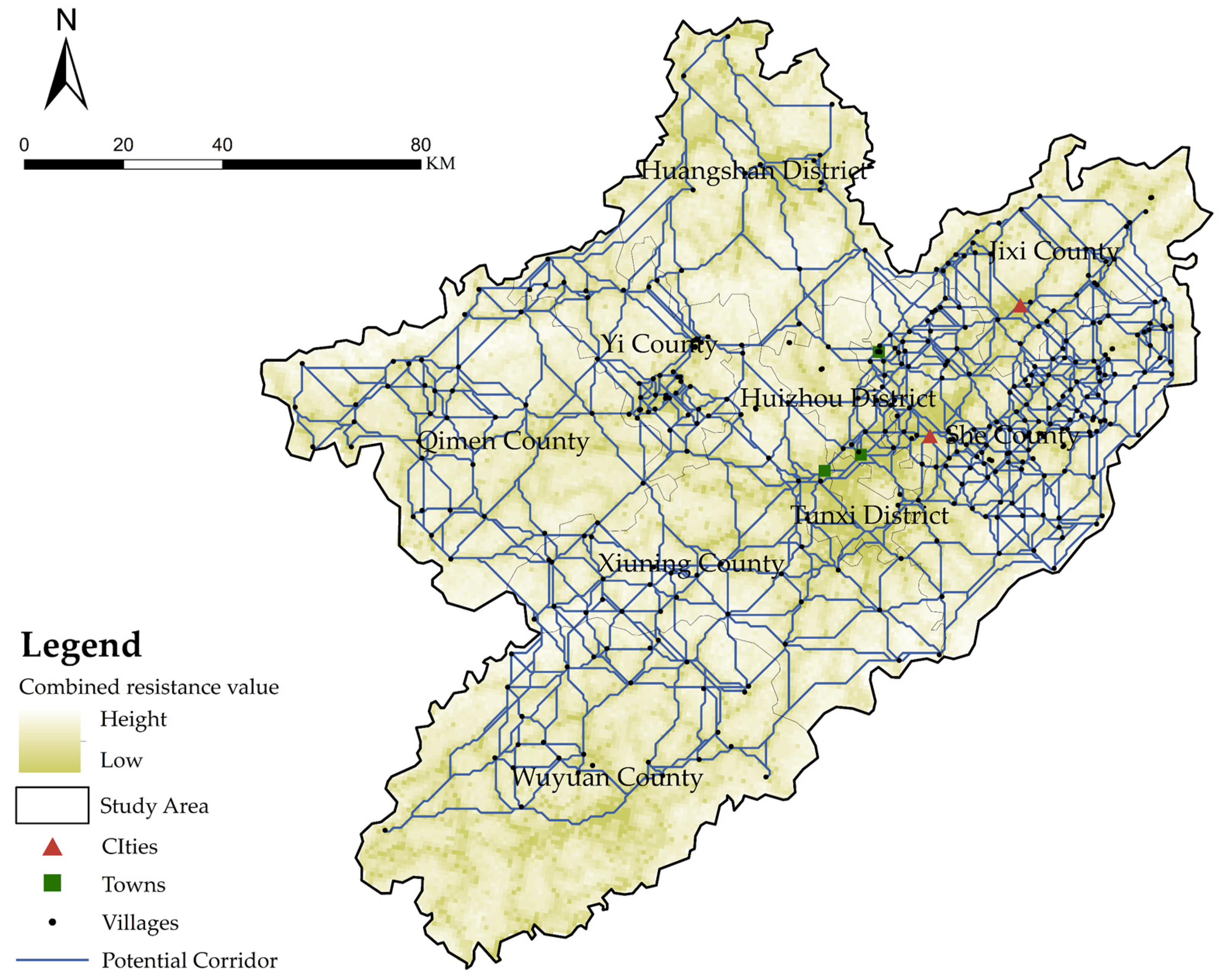
4.2.3. Construction of Heritage Corridors

In circuit theory, if corridor paths, historic resources, and other components change, the network’s connection and structure will also be dynamically modified. When an element changes, the current flow path will also change, and the system continuously optimizes the path through a feedback mechanism to maximize the current transfer, thus maintaining the stability and adaptability of the overall network [40]. This study uses circuit theory to create a spatial network of heritage corridors and incorporates the charge transfer mechanism seen in biological migration into heritage spatial analysis to investigate the dynamic adaptive characteristic of heritage corridors.
In the analogy process, traditional settlement heritage sites are equated as circuit nodes and the communication paths between heritage sites are regarded as conductors to simulate the circulation pattern of cultural information in spatial networks. In this study, 376 national-level traditional settlements were used as source points, and the integrated resistance surface of heritage corridors was constructed by considering the topographic conditions, land use types, and traffic accessibility; simulation analyses were carried out with the Linkage Mapper tool to finally generate 942 potential heritage corridors (Figure 9). In the simulation process, each settlement takes turns to be the starting point to ensure that the network covers all important colony nodes in the study area, so that the corridor system has a more complete spatial relevance.
To rationally organize the heritage spatial network structure, this study uses a quantitative classification method to systematically divide the many potential corridors generated based on circuit theory simulation: by calculating the ratio of CWD to PL (CWD/PL), and based on its numerical distribution characteristics, all heritage corridors are divided into three levels. The lowest CWD/PL value is the key corridor (1.21 < CWD/PL ≤ 2.38), followed by the important corridor (2.38 < CWD/PL ≤ 3.23), and the highest CWD/PL value is the general corridor (3.23 < CWD/PL ≤ 4.46). Finally, 245 key corridors, 312 important corridors, and 385 general corridors were determined (Figure 10), laying the foundation for the subsequent heritage network function analysis and protection strategy formulation.
On this basis, combined with local chronicles and existing research results [57,67], the study systematically interpreted the role of corridors of different levels in the overall network from the two dimensions of cultural coherence and practical feasibility. The results show that key corridors mainly connect core traditional settlements with significant cultural value and constitute the spatial skeleton of the heritage network; important corridors help to strengthen the interactive connection between settlements within the county and promote the coordinated development of regional culture; general corridors improve the accessibility and connectivity of marginal areas, provide support for daily cultural exchanges between traditional settlements, and enhance the overall penetration and coverage of the network.
Spatial analysis shows that the key corridors are distributed in the shape of a cross axis, depending on the southeastern heritage area of She County, the central heritage cluster area of Yi County, and the transition area between Xiuning and Wuyuan to form a triangular geographical fulcrum. A spatial closed-loop system is constructed through discretely distributed key corridors; important corridors are scattered in a network, covering the entire area and connecting major settlement nodes; general corridors form a ring structure, connecting the southeastern She County, the central Yi County and the Xiuning–Wuyuan junction area, and finally forming an overall closely connected ring heritage corridor system.

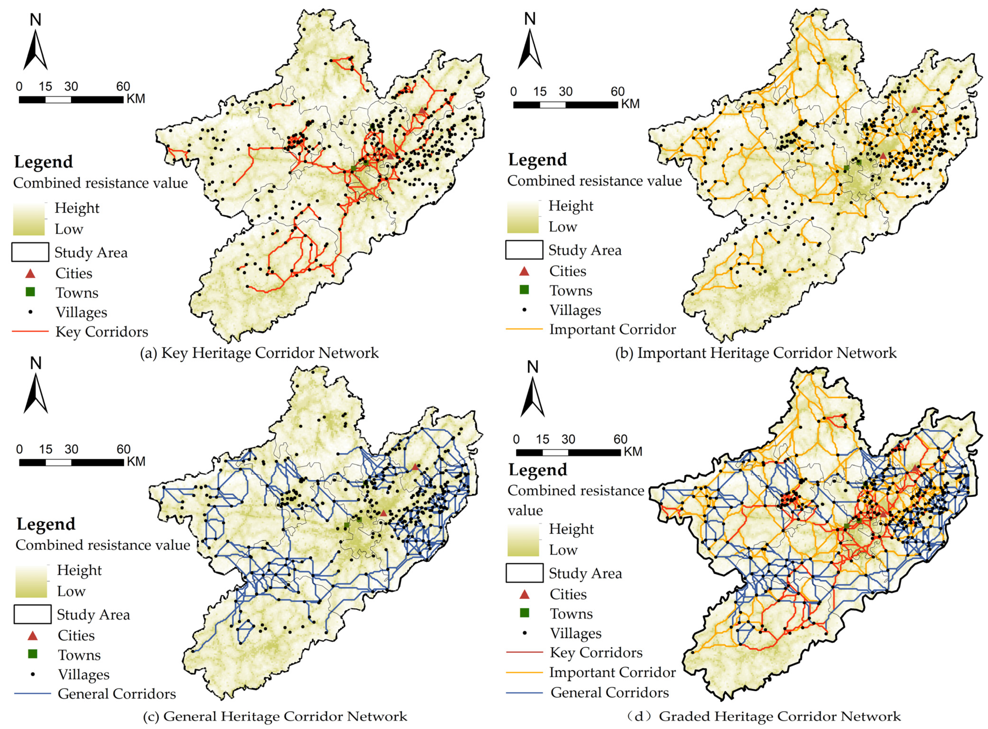
4.2.4. Analysis of Heritage Corridor Network

With the help of sDNA tools, this research abstracted the heritage corridors into line segment topological networks. To break through the limitations of traditional single radius analysis, two different analysis radii were set: one is an overall search radius of 15 km to meet the coordination needs within the county; the other is a global unbounded radius (R = N) to support cross-regional linkage integration. The choice of a 15 km radius is based on the average service radius of one-way urban and rural buses, which can effectively depict the spatial boundaries of daily cultural and economic interactions between settlements. The overall radius eliminates geographical constraints, allowing cross-city heritage corridors to form a closer connection in the overall network, thereby enhancing regional synergy.
This research uses the natural breakpoint approach to identify the degree of betweenness and closeness of heritage corridors into five groups: high-level, higher-level, middle-level, lower-level, and low-level. The results of the betweenness show that the transportation network in the study area has obvious spatial differences (Figure 11a,b). At the overall scale, the high betweenness corridors are discretely distributed along the northeast–southwest axis, and their spatial orientation is highly consistent with the distribution orientation of traditional settlements. At the local scale, the whole area of She County and Jixi County and the core area of Yi County form a dense zone of betweenness; this spatial distribution shows a strong correlation with the density of settlements, suggesting that there is a positive synergistic mechanism between the distribution of heritage settlements and the traffic carrying capacity at the county scale. However, from an overall perspective, the high percentage of low betweenness corridors exposes the systematic lack of direct access corridors, which may become an important factor constraining the overall connectivity efficiency of heritage corridors.
The results of the closeness (Figure 11c,d) show that at the overall scale, She County, as the core hub, extends its radiation range along the northwest–southwest axis, showing a monocentric radial structure, which forms a spatial echo with the centripetal agglomeration characteristic of the traffic flow in the Huangshan city area. At the local scale, the areas with higher closeness are mainly concentrated in the whole area of She County and the center of Yi County, forming a relatively independent group structure with less connection with each other. Multi-scale comparison shows that at the overall scale, the proportion of corridors with medium–high closeness is significantly higher than that at the local scale, and their spatial continuity is stronger. At the cross-regional scale, the accessibility of heritage corridors is better guaranteed, while within the county, the network of heritage corridors is still characterized by a certain degree of fragmentation, which needs to be further optimized.

5. Discussion

5.1. Constructing a “Three-Core-Driven, Two-Axis Linkage, Multi-Source Synergy” Protection Mechanism

5.1.1. Constructing a “Three-Core Synergy, Corridor Symbiosis” Protection System

Based on the distribution of heritage corridors in Huizhou traditional settlements, this study proposes a multi-level protection framework of “three-core synergy, corridor symbiosis” (Figure 12), aiming to promote the systematic coupling of settlement heritage protection and regional development through the optimization of the spatial structure and functional synergy mechanisms. The spatial structure of the system presents a water network, heritage radiation, and ecological transition of three dimensions:
  • The water network takes the water vein cultural core of She County as the hub, relies on the Xin’an River water corridor, and connects the riverside settlements such as Xu Village and Changxi Village through the core node of Huizhou Ancient City, forming a “water vein weaving network” style spatial sequence, strengthening the historical connection between water and land, and restoring the water culture interaction between settlements.
  • Heritage radiation takes Yi County double legacy artisan nucleus as the center, relying on Xidi Village and Hong Village world cultural heritage sites, constructs a radial network with a radius of 15 km, linking Namping village, Guanlu Village and other Ming and Qing dynasty trade settlement clusters, forming a core-driven cultural dissemination system with the synergistic development of the peripheral settlements, and further expanding the cultural influence of the traditional settlements.
  • The ecological transition level relies on the Xiuwu County Marginal exchange nucleus, based on the ecological barrier of Wulong Mountain Range, and through the linkage of terrace ecosystem of Huangling Village and high mountains of Mulihong Village, to construct the cultural transition belt of Anhui and Jiangxi, forming a spatial pattern of ecological protection and cultural integration in parallel.
In the functional positioning, the core area is combined with its regional characteristics to form a differentiated division of labor. She County area, due to the dense water system settlements, the ancient city of deep cultural heritage bears the core function of cultural services, strengthens the historical and cultural display function, and through the Xin’an River waterway and other transport networks, enhances the efficiency of cultural dissemination. The Yi County area relies on traditional architectural groups and artisan skills tradition, focusing on the living heritage of skills, and promoting the transformation of cultural heritage, industrialization, and innovative development. Xiuwu Area, with its unique mountain ecosystem and border cultural characteristics, plays the role of ecological transition and cultural exchange, promotes the collaborative protection of the Anhui–Jiangxi region, and facilitates the inter-provincial development of heritage linkage.
The three core districts are connected by rings to build a synergistic network of “core-driven, interconnected corridors”. To make the settlement’s heritage form a mutually supportive organic whole in a multi-scale space, the system uses spatial linkage and functional complementarity to strengthen each area’s unique advantages while also improving overall protection efficiency through corridor resource integration. Finally, it establishes a dynamic balance mechanism between historical preservation and regional development that supports the continued growth of ancient Huizhou’s traditional settlement.

5.1.2. Strengthening the “Twin-Axis” Protection System

The key corridor is the core framework of the Huizhou heritage network, which plays a key role in the continuity protection and spatial organization optimization of the cultural lineage. Currently, the key corridor is centered on She County, radiating to Yi County and Wuyuan County in a “cross” pattern, forming a stable spatial structure. Based on its spatial characteristics, this study proposes the conservation strategy of “cultural heritage axis” and “ecological and humanistic axis” to strengthen the overall conservation system of Huizhou heritage (Figure 13).
The cultural heritage axis connects the core heritage sites of Huizhou Old Town, Xidi Village, Hong Village, etc. It is an area where Huizhou culture is more concentrated, carrying core cultural elements such as Huizhou architecture, academy culture, clan system, and Huizhou merchant history, etc. The conservation strategy of this axis focuses on the overall maintenance of the historical buildings. The conservation strategy of this axis focuses on the overall maintenance of the historical buildings, strictly controlling the intervention of modern buildings, avoiding the destruction of the landscape, and ensuring the authenticity and integrity of the heritage. Meanwhile, it promotes the living use of cultural heritage and enhances cultural dissemination through digital display, non-heritage experience, and cultural studies.
The ecological and humanistic axis runs through Jixi, Wuyuan, and other regions, rich in natural ecological resources along the line, with traditional settlements built on the mountains and deeply integrated with the landscape environment, forming a unique ecological and cultural landscape of Huizhou. The protection of this axis should adhere to the principle of ecological priority, control the impact of urbanization expansion and excessive tourism development on the ecological environment, and strengthen the synergistic protection of natural landscape and cultural heritage. In the meantime, it can be used in conjunction with a rural revitalization method to encourage local settlements to actively participate in heritage management, promote the living inheritance of traditional farming culture, and rely on low-intervention methods such as ecological trails, cultural studies, and rural experience to achieve synergy between conservation and cultural development and build a sustainable heritage preservation model.

5.1.3. Identify Transport Hub Nodes

This study screened hub nodes based on the quantitative standard of “number of times crossed by corridors” to enhance the connectivity of corridor networks and the spatial connection between settlements. All traditional settlements were used as potential connection points, and settlements crossed 8 times or more were identified as transportation hub nodes. The 41 core nodes with significant connection characteristics were screened from traditional settlements across the region, including 5 nodes crossed 10 times, 8 nodes crossed 9 times, and 28 nodes crossed 8 times (Figure 14). These transportation hub nodes are spread throughout Huizhou. The high-frequency crossing feature ensures network coverage of major corridors, and the clear number of times avoids node redundancy. At the same time, the threshold is located in the interval of significant change in network connectivity, which enables the transport system to achieve an optimal balance between operational efficiency and service coverage.

5.2. Heritage Corridor Protection Strategy Based on sDNA

This study combines the betweenness and closeness indicators of sDNA to construct a dual-scale protection framework of the regional level and the county level, targeting the spatial characteristics of ancient Huizhou, which spans the two provinces of Anhui and Jiangxi. At the regional level, the framework addresses the integration of cultural resources across administrative boundaries, while at the county scale, it emphasizes the localized expression of settlement culture. Together, these scales form a protection system characterized by spatial coordination and functional complementarity.
1.
Regional Level: Cross-Provincial Resource Integration
For corridors with high cross-provincial betweenness, such as She County–Wuyuan County, Jing County–Wuyuan County, and Huangshan District–Wuyuan County, the primary focus is on establishing inter-provincial joint protection mechanisms. By coordinating the cultural heritage management standards of the two provinces, integrating inter-provincial linear heritage resources such as the Huihang Ancient Road, Huirao Ancient Road, and Xin’anjiang River System, a unified cultural identification system and ecological control corridor are built. As the core channel for provincial cultural interconnection, such corridors need to give priority to repairing the broken nodes in the provincial boundary area, establish a cross-provincial cultural information sharing platform, and simultaneously promote the exchange plan of intangible cultural heritage inheritors to strengthen inter-provincial cultural identity.
Closeness analysis shows that She County, as a central hub, has a radiation range that extends radially along the northwest–southwest axis. The region needs to build a regional heritage coordination center to coordinate cross-provincial cultural resource dispatch and focus on strengthening the service functions of core nodes such as the Huizhou government office and the Xuguo Stone Archway. In areas with low closeness, such as the western part of Qimen County and the northern part of Huangshan District, administrative barriers to cultural flows can be broken through by touring exhibitions and establishing cross-provincial folk art inheritance bases, thereby improving their connection with other regional settlements.
2.
County Level: Corridor Restoration and Node Linkage
The county scale focuses on the local inheritance of settlement culture, and implements precise intervention based on the spatial differentiation characteristics of betweenness and closeness. In high betweenness areas such as She County, Jixi County, and the core area of Yi County, the focus is on promoting the systematic restoration of cultural paths: by integrating the county’s ancient road branches, dock relics, and water system space, a “ancient road-water system-settlement” composite display system is constructed, the historical street interface is restored using traditional masonry techniques, and community intangible cultural heritage workshops and immersive performance spaces are implanted to strengthen the narrative coherence and experience depth of linear heritage. Low betweenness marginal areas adopt a flexible activation strategy, selectively repair scattered historical street nodes, implant micro-cultural stations in combination with agricultural landscapes such as terraces and tea gardens and activate micro-cultural connections through theme exhibitions.
Closeness analysis shows that the entire She County and the central area of Yi County have formed a high-closeness cultural group, but the internal spatial connection is relatively weak. It is necessary to focus on strengthening the cultural radiation function of core nodes such as archways and ancestral halls and improve network service capabilities by adding live performance spaces and smart guide systems. Based on the construction logic of “corridors connecting key nodes and nodes linking secondary settlements”, the county’s post road network is systematically repaired and scattered cultural elements are integrated to enhance the spatial correlation between groups and reconstruct the synergistic symbiosis of traditional regional culture.

6. Conclusions

Traditional settlements in the ancient Huizhou area, as the core carriers of Huizhou culture, are not only living witnesses to Chinese agricultural civilization, but also have important research significance due to their complex cross-regional and multi-dimensional cultural heritage. However, current related research focuses on the protection of single buildings or local cultural phenomena, and systematic correlation research on traditional settlements in Huizhou is still insufficient. Drawing on the heritage corridor theory, it is urgent to reconstruct its protection paradigm from a holistic perspective. The research focused on the spatial distribution of traditional settlements in ancient Huizhou, then used circuit theory and sDNA to create a cross-provincial multi-level historic corridor network and assess its structural characteristics.
The following are the main conclusions of this study: (1) The traditional settlements of ancient Huizhou present a pattern of “small aggregation and large dispersion”, which is mainly influenced by factors in two dimensions: natural geography and social culture. Among them, She County has the highest settlement density and constitutes the spatial core, while the peripheral areas are scattered and fragmented. Kernel density analysis and the standard deviation ellipse method further revealed that the spatial center of gravity of the settlements migrated toward the core area of Huizhou along a “6”-shaped trajectory, and the spatial expansion direction had obvious policy-driven characteristics. (2) Through circuit theory simulation, 942 potential heritage corridors were generated, which were concentrated along the northeast–southwest axis and formed a multi-level, ring-shaped network system. The corridors were divided into three groups: key, important, and general according to the ratio of cumulative resistance to length. The results of sDNA space syntax analysis showed that corridors with higher betweenness were highly consistent with historical and culturally active areas such as She County and Yi County, and were important hubs for regional cultural communication, while areas with lower betweenness reflected their spatial marginality and needed to strengthen network connectivity. (3) Based on the above analysis, the study proposed a protection mechanism of “three-core-driven, two-axis linkage, multi-source synergy”: building a multi-dimensional collaborative network based on the Xin’an River system, the World Heritage Site, and the ecological transition zone, optimizing the spatial organizational structure through the two-axis linkage of the “cultural heritage axis” and the “ecology and humanity axis”, and identifying 41 transportation hubs to enhance the overall network accessibility. This strategy helps to integrate scattered settlement heritage resources and provide a scalable path for cross-administrative region protection planning.
There are still certain restrictions, even though this study has made some progress in analyzing the spatially distributed features of ancient Huizhou settlements and creating heritage corridors. The selection of resistance factors has a significant impact on the circuit theory analysis findings, which heavily depend on the resistance surface factor setting. Although natural geographical factors such as topography, land use, and transportation, as well as some social and cultural factors, have been comprehensively incorporated, non-physical variables such as policy regulation and population migration have not been fully incorporated into the model system due to the difficulty of quantification. To make up for this deficiency, future research can consider introducing a value-based assessment framework, combining indicators such as cultural value, protection status, integrity, and social recognition to grade and evaluate traditional settlements, and incorporate the grading results into the resistance model and heritage corridor construction in a quantitative form.

Author Contributions

Y.W. (Yao Wu) conceptualized the research direction and core content. Y.Y. conducted all experiments and was responsible for the full manuscript writing. M.M., Y.W. (Yonglan Wu), and H.Z. reviewed the manuscript and provided constructive suggestions. All authors have read and agreed to the published version of the manuscript.

Funding

This study was supported by the Academic Degrees and Graduate Education Development Center of the Ministry of Education: Exploration and Practice of Value-oriented Architectural Heritage Conservation Methods: A Case Study of Suzhou and Macao (ZT-231028509).

Data Availability Statement

The datasets used and analyzed during the current study are available from the corresponding author upon reasonable request.

Conflicts of Interest

The authors declare no conflicts of interest.

Abbreviations

The following abbreviations are used in this manuscript:
UNESCOUnited Nations Educational, Scientific and Cultural Organization
HULHistoric Urban Landscape
AHPAnalytic Hierarchy Process
MCRMinimum Cumulative Resistance
GISGeographic Information System
CCSPMCultural Corridor Spatial Planning Model
NHANational Heritage Areas
DEMDigital Elevation Model
OSMOpenStreetMap
ANNAverage Nearest Neighbor
sDNAspatial Design Network Analysis
CWD/PLCumulative Resistance Distance/Path Length Ratio
NQPDANetwork Quantity Penalized by Distance Angular

References

  1. Tao, J.; Li, G.; Xiao, D.; Zhuo, X. Evolution and Prospects of Traditional Rural Settlements in China. South Archit. 2024, 1–24. (In Chinese) [Google Scholar] [CrossRef]
  2. Liu, P.; Zeng, C.; Liu, R. Environmental Adaptation of Traditional Chinese Settlement Patterns and Its Landscape Gene Mapping. Habitat Int. 2023, 135, 102808. [Google Scholar] [CrossRef]
  3. Izakovičová, Z.; Petrovič, F.; Pauditšová, E. The Impacts of Urbanisation on Landscape and Environment: The Case of Slovakia. Sustainability 2022, 14, 60. [Google Scholar] [CrossRef]
  4. Lu, S.; Rao, X.; Duan, P. Rural Gentrification and Its Impacts in Traditional Villages—A Case Study of Xixinan Village, China. Sustainability 2022, 14, 10077. [Google Scholar] [CrossRef]
  5. Li, J.; Wang, J.; Li, X. Heritage Value Assessment and Landscape Preservation of Traditional Chinese Villages Based on the Daily Lives of Local Residents: A Study of Tangfang Village in China and the UNESCO HUL Approach. Land 2024, 13, 1535. [Google Scholar] [CrossRef]
  6. Ma, K. Research of Spatial Network Elements and Its Structure Characteristics in Ancient Huizhou Traditional Settlements. Master’s Thesis, Anhui Jianzhu University, Hefei, China, 2018. (In Chinese). [Google Scholar]
  7. Bhati, H.V.; Epstein, Y. Protection of Biocultural Heritage in the Anthropocene: Towards Reconciling Natural, Cultural, Tangible and Intangible Heritage. J. Environ. Law 2023, 35, 353–375. [Google Scholar] [CrossRef]
  8. Liu, X.; Yuan, L.; Tan, G. Identification and Hierarchy of Traditional Village Characteristics Based on Concentrated Contiguous Development—Taking 206 Traditional Villages in Hubei Province as an Example. Land 2023, 12, 471. [Google Scholar] [CrossRef]
  9. Wang, D.; Zhu, Y.; Zhao, M.; Lv, Q. Multi-Dimensional Hollowing Characteristics of Traditional Villages and Its Influence Mechanism Based on the Micro-Scale: A Case Study of Dongcun Village in Suzhou, China. Land Use Policy 2021, 101, 105146. [Google Scholar] [CrossRef]
  10. Zhang, L.; Sun, J.; Deng, L.; Luo, J.; Tian, Y. Characteristics of multi-scale spatiotemporal pattern and influencing factors of Chinese traditional villages. Res. Soil Water Conserv. 2025, 32, 321–330. (In Chinese) [Google Scholar] [CrossRef]
  11. Li, G.; Hu, W. A Network-Based Approach for Landscape Integration of Traditional Settlements: A Case Study in the Wuling Mountain Area, Southwestern China. Land Use Policy 2019, 83, 105–112. [Google Scholar] [CrossRef]
  12. He, D.; Chen, W.; Zhang, J. Integrating Heritage and Environment: Characterization of Cultural Landscape in Beijing Great Wall Heritage Area. Land 2024, 13, 536. [Google Scholar] [CrossRef]
  13. Pendlebury, J. The Conservation of Historic Areas in the UK. Cities 1999, 16, 423–433. [Google Scholar] [CrossRef]
  14. Sebti, M.; Alkama, D.; Bouchair, A. Assessment of the Effect of Modern Transformation on the Traditional Settlement ‘Ksar’ of Ouargla in Southern Algeria. Front. Archit. Res. 2013, 2, 322–337. [Google Scholar] [CrossRef]
  15. Liu, X.; Li, Y.; Wu, Y.; Li, C. The Spatial Pedigree in Traditional Villages under the Perspective of Urban Regeneration-Taking 728 Villages in Jiangnan Region, China as Cases. Land 2022, 11, 1561. [Google Scholar] [CrossRef]
  16. Zhong, Q.; Dong, T. Exploring the Spatiotemporal Trends and Influencing Factors of Human Settlement Suitability in Hunan Province Traditional Villages. Sci. Rep. 2024, 14, 25319. [Google Scholar] [CrossRef]
  17. Feng, Y.; Wei, H.; Huang, Y.; Li, J.; Mu, Z.; Kong, D. Spatiotemporal Evolution Characteristics and Influencing Factors of Traditional Villages: The Yellow River Basin in Henan Province, China. Herit. Sci. 2023, 11, 97. [Google Scholar] [CrossRef]
  18. Laven, D.; Ventriss, C.; Manning, R.; Mitchell, N.; Evaluating, U.S. National Heritage Areas: Theory, Methods, and Application. J. Environ. Manag. 2010, 46, 195–212. [Google Scholar] [CrossRef]
  19. Zingraff-Hamed, A.; Bonnefond, M.; Bonthoux, S.; Legay, N.; Greulich, S.; Robert, A.; Rotgé, V.; Serrano, J.; Cao, Y.; Bala, R.; et al. Human–River Encounter Sites: Looking for Harmony between Humans and Nature in Cities. Sustainability 2021, 13, 2864. [Google Scholar] [CrossRef]
  20. Hu, X.; Li, H.; Zhang, X.; Chen, X.; Yuan, Y. Multi-Dimensionality and the Totality of Rural Spatial Restructuring from the Perspective of the Rural Space System: A Case Study of Traditional Villages in the Ancient Huizhou Region, China. Habitat Int. 2019, 94, 102062. [Google Scholar] [CrossRef]
  21. Fang, Q.; Li, Z. Cultural Ecology Cognition and Heritage Value of Huizhou Traditional Villages. Heliyon 2022, 8, e12627. [Google Scholar] [CrossRef]
  22. Wang, X.; Lai, J.; Guo, Y. Study on Tourism Responsiveness and Habitat Environment-Influencing Factors of Traditional Villages in Huizhou Area. Sustainability 2024, 16, 3424. [Google Scholar] [CrossRef]
  23. Wang, W.; Liu, A.; Xu, X. The Spatio-Temporal Evolution and Sustainable Development Strategy of Huizhou’s Traditional Villages in the Xin’an River Basin. Land 2025, 14, 102. [Google Scholar] [CrossRef]
  24. Chen, X.; Xie, W.; Li, H. The Spatial Evolution Process, Characteristics and Driving Factors of Traditional Villages from the Perspective of the Cultural Ecosystem: A Case Study of Chengkan Village. Habitat Int. 2020, 104, 102250. [Google Scholar] [CrossRef]
  25. Ding, J.; Gao, Z.; Ma, S. Understanding Social Spaces in Tourist Villages through Space Syntax Analysis: Cases of Villages in Huizhou, China. Sustainability 2022, 14, 12376. [Google Scholar] [CrossRef]
  26. Bian, M.; Huang, Z.; Chen, Q.; Liu, G.; Zhang, Y.; Ding, S. Optimization of Plane and Space of New Dwellings in Southern Anhui Province Based on Indoor Thermal Environment. Sustainability 2022, 14, 5694. [Google Scholar] [CrossRef]
  27. Yue, F.; Li, X.; Huang, Q.; Li, D. A Framework for the Construction of a Heritage Corridor System: A Case Study of the Shu Road in China. Remote Sens. 2023, 15, 4650. [Google Scholar] [CrossRef]
  28. Du, C.; Pan, D.; Liu, Q. The Construction of a Protection Network for Traditional Settlements across Regions: A Case Study of the Chengdu–Chongqing Ancient Post Road Heritage Corridor in China. Land 2025, 14, 327. [Google Scholar] [CrossRef]
  29. Fan, X.; Wang, Z.; Li, S. Value Evaluation Model (VEM) of Ancient Chinese Military Settlement Heritage: A Case Study of Liaoxi Corridor in the Ming Dynasty. Herit. Sci. 2024, 12, 97. [Google Scholar] [CrossRef]
  30. Wang, Q.; Yang, C.; Wang, J.; Tan, L. Tourism in Historic Urban Areas: Construction of Cultural Heritage Corridor Based on Minimum Cumulative Resistance and Gravity Model—A Case Study of Tianjin, China. Buildings 2024, 14, 2144. [Google Scholar] [CrossRef]
  31. Lin, F.; Zhang, X.; Ma, Z.; Zhang, Y. Spatial Structure and Corridor Construction of Intangible Cultural Heritage: A Case Study of the Ming Great Wall. Land 2022, 11, 1478. [Google Scholar] [CrossRef]
  32. Li, X.; Zhu, R.; Shi, C.; Yang, X.; Chen, J.; Wei, K. Research on the Construction of Intangible Cultural Heritage Corridors in the Yellow River Basin Based on Geographic Information System (GIS) Technology and the Minimum Cumulative Resistance (MCR) Model. Herit. Sci. 2024, 12, 271. [Google Scholar] [CrossRef]
  33. Ye, H.; Yang, Z.; Xu, X. Ecological Corridors Analysis Based on MSPA and MCR Model—A Case Study of the Tomur World Natural Heritage Region. Sustainability 2020, 12, 959. [Google Scholar] [CrossRef]
  34. Zhang, Q.; Ge, J. Research on the Construction of Huizhou Heritage Corridor Network from the Perspective of Cultural Ecology. Ind. Constr. 2024, 54, 20–29. [Google Scholar] [CrossRef]
  35. Sun, Y.; Wang, Y.; Liu, L.; Wei, Z.; Li, J.; Cheng, X. Large-Scale Cultural Heritage Conservation and Utilization Based on Cultural Ecology Corridors: A Case Study of the Dongjiang-Hanjiang River Basin in Guangdong, China. Herit. Sci. 2024, 12, 44. [Google Scholar] [CrossRef]
  36. Tao, L.; Wang, H.; Li, J.; Zhang, L. Construction of CCSPM model for spatial definition of cultural corridor. A case study of cross-border cultural corridor in Southwest Yunnan. Geogr. Sci. 2022, 42, 602–610. (In Chinese) [Google Scholar] [CrossRef]
  37. Yu, K.; Xi, X.; Li, D.; Li, H.; Liu, K. On the Construction of the National Linear Culture Heritage Network in China. Hum. Geogr. 2009, 24, 11–16, 116. (In Chinese) [Google Scholar] [CrossRef]
  38. Yuan, Y.; Xu, J.; Zhang, X. Construction of Heritage Corridor Network Based on Suitability Analysis: A Case Study of the Ancient Capital of Luoyang. Remote Sens. Inf. 2014, 29, 117–124. (In Chinese) [Google Scholar] [CrossRef]
  39. Zhang, S.; Yu, W. Canal Heritage Tourism Utilization Models: Experience and Inspirations from the Grand Canal (Beijing Section). Land 2024, 13, 860. [Google Scholar] [CrossRef]
  40. Wu, Y.; Miao, M.; Wu, Y.; Zhu, H.; Li, X.; Candeias, A. The Research on the Construction of Traditional Village Heritage Corridors in the Taihu Lake Region Based on the Current Effective Conductance (CEC) Theory. Buildings 2025, 15, 472. [Google Scholar] [CrossRef]
  41. Ministry of Culture and Tourism of the People’s Republic of China. Available online: https://www.mct.gov.cn (accessed on 5 March 2025).
  42. China Traditional Villages Network. Available online: http://www.chuantongcunluo.com (accessed on 5 March 2025).
  43. Resource and Environment Science Data Center, Chinese Academy of Sciences. Available online: http://www.resdc.cn (accessed on 23 February 2025).
  44. Baidu Coordinate Pickup System. Available online: https://api.map.baidu.com/lbsapi/getpoint/index.html (accessed on 10 March 2025).
  45. Geospatial Data Cloud. Available online: http://www.gscloud.cn (accessed on 23 February 2025).
  46. National Basic Geographic Information Center. Available online: http://www.ngcc.cn (accessed on 23 February 2025).
  47. OpenStreetMap. Available online: http://www.openstreetmap.org (accessed on 24 February 2025).
  48. Wang, Y.; Li, Y.; Zhai, B.; Feng, X. Heritage Network Theory and ltsImplications for the Conservation Renewal of Historic Cities. Urban Archit. 2024, 21, 38–43. (In Chinese) [Google Scholar] [CrossRef]
  49. Tian, Y.; Chen, P.; Lu, P.; Yang, H.; Yang, S.; Zhang, L.; Wei, Q.; Zhao, X.; Guo, L.; Wang, Z.; et al. Evolution of Influence Ranges of Neolithic-Bronze Age Cities in the Songshan Mountain Region of Central China Based on GIS Spatial Analysis. Remote Sens. 2022, 14, 5631. [Google Scholar] [CrossRef]
  50. Zhang, Y.; Li, J.; Wang, J.; Xin, A. Spatial Correlation between Traditional Villages and Religious Cultural Heritage in the Hehuang Region, Northwest China. J. Asian Archit. Build. Eng. 2024, 1–13. [Google Scholar] [CrossRef]
  51. Ning, Z.Z.; Wang, T.; Yang, X.C. Spatio-Temporal Evolution of Tourist Attractions and Formation of Attraction Clusters in China since 2001. Geogr. Res. 2020, 39, 1654–1666. [Google Scholar]
  52. Esbah, H.; Cook, E.A.; Ewan, J. Effects of Increasing Urbanization on the Ecological Integrity of Open Space Preserves. Environ. Manag. 2009, 43, 846–862. [Google Scholar] [CrossRef]
  53. Zhang, L.; Tian, F.; Zheng, X.; Sun, Z. Spatial Configuration of Fire Protection for Historical Streets in China Using Space Syntax. J. Cult. Herit. 2023, 59, 140–150. [Google Scholar] [CrossRef]
  54. Li, J.; Chu, J.; Ye, J.; Liu, H.; Zhang, J. Spatial Evolutionary Characteristics and Driving Mechanism of Traditional Villages in Ancient Huizhou. Econ. Geogr. 2018, 38, 153–165. (In Chinese) [Google Scholar] [CrossRef]
  55. Lu, S.; Zhang, X. Temporal-Spatial Distribution Characteristics and Impact Factors of Traditional Villages in Huizhou Area. Econ. Geogr. 2019, 39, 204–211. (In Chinese) [Google Scholar] [CrossRef]
  56. Lu, L.; Ling, S.; Jiao, H.; Yang, X. Study on evolution process and mechanism of Huizhou ancient village. Geogr. Res. 2004, 5, 686–694. (In Chinese) [Google Scholar] [CrossRef]
  57. Shao, Y.; Chen, H.; Hu, L. The System,Types and Characteristics of Historic Settlements in Southern Anhui. Herit. Archit. 2021, 1, 38–51. (In Chinese) [Google Scholar] [CrossRef]
  58. Yang, J.; Ren, K. Analysis of the Types and Characteristics of Huizhou’s Characteristic Villages and Towns. J. Hum. Settl. West. China 2023, 38, 1–8. (In Chinese) [Google Scholar] [CrossRef]
  59. Ding, Q.; Yang, Z.; Huang, Z. Spatial and Temporal Distribution Characteristics and Geographic Contexts of Civilized Villages in China. PLoS ONE 2024, 19, e0305591. [Google Scholar] [CrossRef] [PubMed]
  60. Fang, Y.; Lu, H.; Huang, Z.; Zhu, Z. Spatiotemporal Distribution of Chinese Traditional Villages and Its Influencing Factors. Econ. Geogr. 2023, 43, 187–196. (In Chinese) [Google Scholar] [CrossRef]
  61. Yang, Q.; Zhang, F.; An, Y.; Sun, C.; Wu, J.; Zhang, Y.; Wei, Z. Research on the Spatial Distribution Pattern and Influencing Factors of China’s Antipoverty (pro-Poor Tourism) on GIS. Discret. Dyn. Nat. Soc. 2021, 2021, 6682498. [Google Scholar] [CrossRef]
  62. Zhang, H.; Wang, Y.; Qi, Y.; Chen, S.; Zhang, Z. Assessment of Yellow River Region Cultural Heritage Value and Corridor Construction across Urban Scales: A Case Study in Shaanxi, China. Sustainability 2024, 16, 1004. [Google Scholar] [CrossRef]
  63. Wang, Y.; Chen, X. The Construction of Red Cultural Heritage Corridor in Jinggang Mountain Based on MCR Model. Huazhong Archit. 2024, 42, 51–55. (In Chinese) [Google Scholar] [CrossRef]
  64. Huang, H.; Zhang, M.; Yu, K.; Gao, Y.; Liu, J. Construction of Complex Network of Green Infrastructure in Smart City under Spatial Differentiation of Landscape. Comput. Commun. 2020, 154, 380–389. [Google Scholar] [CrossRef]
  65. Zhao, Y.; Cao, J.; Zhang, X.; Zhang, M. Analyzing the Characteristics of Land Use Distribution in Typical Village Transects at Chinese Loess Plateau Based on Topographical Factors. Open Geosci. 2022, 14, 429–442. [Google Scholar] [CrossRef]
  66. Wang, F.; Gao, C. Settlement-River Relationship and Locality of River-Related Built Environment. Indoor Built Environ. 2020, 29, 1331–1335. [Google Scholar] [CrossRef]
  67. Chu, J.L.; Li, Y.; Li, J.L. Present Characteristics and Protection Path of Linear Cultural Heritage Based on “Patch-Corridor-Matrix”: A Case of Huizhou Ancient Road. Small Town Constr. 2019, 37, 46–52, 60. (In Chinese) [Google Scholar] [CrossRef]
Figure 1. Status of traditional settlements in ancient Huizhou.
Buildings 15 01641 g001
Figure 2. Research area and research subjects.
Buildings 15 01641 g002
Figure 3. Schematic diagram of heritage corridor network.
Buildings 15 01641 g003
Figure 4. Research framework.
Buildings 15 01641 g004
Figure 5. Nearest neighbor index for traditional settlements in ancient Huizhou.
Buildings 15 01641 g005
Figure 6. Kernel density analysis of traditional settlements in ancient Huizhou area.
Buildings 15 01641 g006
Figure 7. Distribution of traditional villages in ancient Huizhou area.
Buildings 15 01641 g007
Figure 8. Distribution of resistance surface in ancient Huizhou area.
Buildings 15 01641 g008
Figure 9. Potential heritage corridor network of settlements in ancient Huizhou area.
Buildings 15 01641 g009
Figure 10. Graded heritage corridor network of settlements in ancient Huizhou area.
Buildings 15 01641 g010
Figure 11. Spatial distribution of heritage corridor betweenness and closeness in ancient Huizhou area.
Buildings 15 01641 g011
Figure 12. Spatial organization model of “three nuclei synergistic, corridor symbiosis”.
Buildings 15 01641 g012
Figure 13. “Dual-axis linkage” protection system.
Buildings 15 01641 g013
Figure 14. Schematic diagram of transport hub nodes.
Buildings 15 01641 g014
Table 1. The number and proportion of settlements in the study area.
ProvincesCityCountyArea
(km2)
Villages (Number)Towns
(Number)
Cities
(Number)
TotalProportion (%)
Anhui ProvinceHuangshan CityShe County2827.21167111690.449
Yi County1140.424600460.122
Xiuning County2805.853710380.101
Qimen County2948.243300330.088
Huangshan District2337.541300130.035
Huizhou District556.181210130.035
Tunxi District255.2420020.005
Xuancheng CityJixi County1474.53101320.085
Jiangxi ProvinceShangrao CityWuyuan County3894.303000300.080
Table 2. Type and source of data.
Data TypeData Source
Traditional Settlement DataMinistry of Culture and Tourism of the People’s Republic of China [41], China Traditional Villages Network [42]
Administrative BoundariesResource and Environmental Science Data Center of the Chinese Academy of Sciences [43]
Traditional Settlement Coordinate PointsBaidu Coordinate Pickup System [44]
DEM Elevation DataGeospatial Data Cloud Platform [45]
Land Use Type, Settlement DataNational Basic Geographic Information Center [46]
Road Traffic, Water System DataOpenStreetMap Platform [47]
Table 3. ANN analysis of traditional settlements in different regions of ancient Huizhou.
ProvinceCityCountyObserved Mean
Distance (m)
Expected Mean
Distance (m)
Nearest Neighbor Ratioz Scorep ValueDistribution Type
Anhui ProvinceXuancheng CityJixi County2391.5553448.3540.694−3.2640.001Clustered
Huangshan CityQimen County5905.9854726.0071.2502.7440.006Dispersed
Xiuning County5042.9884354.1331.1581.8410.066Dispersed
Huangshan
District
8502.0566704.6771.2681.8490.064Dispersed
Yi County2199.1212489.5670.883−1.5140.13Random
She County1949.5852051.1370.950−1.2280.22Random
Huizhou District3859.6833270.4491.181.2430.214Random
Tunxi District2214.3975648.4720.392−1.6450.1Random
Jiangxi ProvinceShangrao CityWuyuan County5125.3835696.7100.900−1.0510.293Random
Table 4. Standard deviation ellipse changes in number of traditional villages in ancient Huizhou.
BatchCenter X (°)Center Y (°)X Std Dist (km)Y Std Dist (km)Rotation (°)Circumference (km)Area (km2)Oblateness
First batch118.07727729.81580549.73638.25037.092277.5915976.2470.231
First 2 batches118.03022929.79403451.79141.11543.801292.8326689.3020.206
First 3 batches118.04935829.80786756.74842.07251.433312.1617500.1130.259
First 4 batches118.09458529.82637661.06539.56360.497319.7447589.2760.352
First 5 batches118.25846429.8776465.66134.3773.266321.9817089.1650.477
First 6 batches118.25741729.87983564.66234.84674.390319.6647078.2130.461
Table 5. Summary of relevant studies.
Serial NumberResistance Factor
1Land Use Type, Elevation, Slope [32]
2Land Use Type, Elevation, Slope, Distance from Major Roads [62]
3Land Use Type, Elevation, Slope, Distance from Major Roads, Distance from Rivers [31]
4Land Use Type, Elevation, Slope, Distance from Major Roads, Distance from Rivers [35]
5Land Use Type, Elevation, Slope, Distance from Major Roads, Distance from Rivers [33]
6Land Use Type, Elevation, Slope, Distance from Major Roads, Distance from Rivers, Distance from Residential Area [63]
7Land Use Type, Elevation, Slope, NDVI, Distance from Major Roads, Distance from Rivers [64]
8Land Use Type, Elevation, Slope, Distance from Major Roads, Distance from Rivers, Distance from Restaurants, Distance from Scenic Spots, Distance from Hotels [27]
9Land Use Type, Elevation, Slope, Slope aspect, Distance from Major Roads, Distance from Rivers, Vegetation Cover, Distance from Public Transportation Stations, Distance from Public Service Facilities [30]
10Land Use Type, Elevation, Slope, Distance from Major Roads, Vegetation Cover, Water Body Buffer Analysis, Terrain Relief, Night Light Index, Distance from Restaurants, Distance from Hotels, Distance from Scenic Spots [34]
Table 6. Resistance factors and their weights of ancient Huizhou traditional settlement heritage corridor.
TypeResistance FactorWeightResistance Value
12345
Natural EnvironmentElevation (m)0.106<200200–400400–600600–800>800
Slope (°)0.145<55–1010–2525–40>40
Types of Land Use0.280Construction land, unused landCultivated landGrasslandRiver systemForest land
Distance from Rivers0.095<0.50.5–11–2.52.5–5>5
Society and CultureNight Light Index0.053>126–122.5–60.5–2.5<0.5
Distance from Residential Area0.148<22–55–1010–15>15
Distance from Major Roads0.173<200200–500500–10001000–1500>1500
Disclaimer/Publisher’s Note: The statements, opinions and data contained in all publications are solely those of the individual author(s) and contributor(s) and not of MDPI and/or the editor(s). MDPI and/or the editor(s) disclaim responsibility for any injury to people or property resulting from any ideas, methods, instructions or products referred to in the content.

