Article

Spatial Sense of Safety for Seniors in Living Streets Based on Street View Image Data

1
School of Architecture & Art Design, Hebei University of Technology, Tianjin 300130, China
2
Urban and Rural Renewal and Architectural Heritage Protection Center, Hebei University of Technology, Tianjin 300130, China
3
Hebei Key Laboratory of Healthy Human Settlement, Tianjin 300130, China
*
Authors to whom correspondence should be addressed.
Buildings 2024, 14(12), 3973; https://doi.org/10.3390/buildings14123973
Submission received: 21 October 2024 / Revised: 1 December 2024 / Accepted: 2 December 2024 / Published: 14 December 2024
(This article belongs to the Section Architectural Design, Urban Science, and Real Estate)

Abstract

:
As the global population ages, the friendliness of urban spaces towards seniors becomes increasingly crucial. This research primarily investigates the environmental factors that influence the safety perception of elderly people in living street spaces. Taking Dingzigu Street in Tianjin, China, as an example, by employing deep learning fully convolutional network (FCN-8s) technology and the semantic segmentation method based on computer vision, the objective measurement data of street environmental elements are acquired. Meanwhile, the subjective safety perception evaluation data of elderly people are obtained through SD semantic analysis combined with the Likert scale. Utilizing Pearson correlation analysis and multiple linear regression analysis, the study comprehensively examines the impact of the physical environment characteristics of living street spaces on the spatial safety perception of seniors. The results indicate that, among the objective environmental indicators, ① the street greening rate is positively correlated with the spatial sense of security of seniors; ② there is a negative correlation between sky openness and interface enclosure; and ③ the overall safety perception of seniors regarding street space is significantly influenced by the spatial sense of security, the sense of security during walking behavior, and the security perception in visual recognition. This research not only uncovers the impact mechanism of the street environment on the safety perception of seniors, but also offers valuable references for the age-friendly design of urban spaces.

1. Introduction

With the rapid development of society and the progress of technology, China is facing an increasingly severe aging problem. According to data from the National Health Commission in 2022, the number of seniors is growing rapidly, and it is expected that during the “14th Five-Year Plan” period, the total population of those aged 60 and above will exceed 300 million, accounting for more than 20% of the total population. By 2035, the number is expected to reach 400 million, accounting for more than 30% of the total population. By the end of 2022, the population of those aged 60 and above had exceeded 280 million, accounting for 19.8% of the total population. From these data, we can see the seriousness of the aging situation in our country, and the problems it generates urgently need to be rectified and adjusted.
The spatial security of seniors refers to their perception of the safety of their surrounding environment, including living streets, parks, and buildings. In 2008, Stephen R. Keller first proposed the concept of integrating human nature into architectural environment design, which involves introducing natural elements into artificial buildings to allow people to interact with nature in their designs. This spatial perception affects their preferences, perceptual judgments, and behaviors [1]. The concept of “perception” comes from environmental psychology and plays an important role as an intermediary between the physical environment of buildings and the behavior of seniors in this study. With the rise of deep learning and public crowdsourcing map service platforms, research has used semantic segmentation to extract various physical feature pixels from SVI as a physical environment measurement index for street view perception. These street view images provide a panoramic ground view of urban streets, providing a low-cost, accurate, and efficient data analysis source for evaluating urban street spaces [2,3].
However, due to the current situation of living street space (as shown in Figure 1) and previous research mainly focusing on the relationship between the physical environment and social interaction in the living street space, there is limited exploration of specific factors affecting the sense of security of seniors in the street environment, and there is a lack of research on the impact mechanism of various spatial environmental indicators on the subjective safety perception of seniors. This study aims to improve the scientific nature of the research on the perception of safety in street space environments for seniors by using street view image data and semantic segmentation technology, which is also one of the important innovations of this study. This study not only explored the factors that affect the sense of security of seniors in the street space, but also analyzed the impact mechanism of the street environment on seniors’ perception of safety comprehensively and in more detail. Through this, this study aims to provide a scientific basis for urban renewal, and ultimately improve the safety and comfort of seniors’ living street space.

2. Literature Review

2.1. Research Aspects of the Safety Perception of Seniors in Living Street Spaces

Livable street spaces are an important part of urban public spaces, especially in old urban areas where street spaces serve the dual functions of public life and transportation. Due to their special physical and psychological needs, seniors have higher expectations for the safety of streets. In Newman’s research (1972), it was pointed out that if residents, especially the elderly, live in environments with damaged street spaces and chaotic social order for a long time, it may exacerbate their sense of insecurity [4]. Jane Jacobs (1961) takes New York and Chicago as examples, foreign studies place more emphasis on the connection between the physical environment of neighborhoods and the social interactions of seniors, ensuring that residents, especially seniors, can supervise various activities in urban spaces in their daily lives, that is, the “watching” role of “eyes on the street” [5,6], to enhance street safety. Meng, L. et al. (2020) studied that the building environment, social environment, and personal health characteristics in urban streets can all affect the safety perception of seniors; for example, the openness, greening level, and interface enclosure of streets have a significant impact on the perception and physical health of street space by senior residents in areas with a high aging population [7]. Especially in the renovation of old community street spaces, safety is the primary factor in the renovation of age-friendly communities. The study by Zeng et al. (2024) showed that improving the height difference of the venue and adding barrier-free facilities can significantly enhance the satisfaction of elderly residents [8].
The physical and mental health and safety issues of seniors in the built environment have always been a focus of multiple disciplines such as urban planning, urban management, and environmental psychology. At present, New York [9] and other European and American cities, as well as cities in China such as Beijing and Shanghai [10], have successively issued corresponding development plans and construction guidelines for age-friendly cities. Therefore, when constructing safe and comfortable urban street spaces, it is important to consider the behavioral and psychological characteristics of different groups, with special attention paid to the senior, low-income, low-education-level, and unemployed populations. Chen Li et al. (2021) believe that streets and communities with good spatial environments can have a significant impact on enhancing residents’ sense of security, and are also a key focus of urban age-friendly renewal [11].

2.2. Research Aspects of the Impact of Street View Images on the Spatial Safety Perception of Seniors

Against the backdrop of the digital age, information technology has become highly developed and interdisciplinary development is prevalent. Deep learning techniques, especially convolutional neural networks (CNNs), have been widely applied in various fields and have demonstrated excellent performance. For example, in the area of image recognition, CNNs have been used to accurately identify and classify objects in street view images with high precision [12]. This has been beneficial in analyzing the elements within street scenes and understanding their relationships with safety perception. In the field of urban planning, CNNs have been employed to predict traffic flow and pedestrian movement patterns, providing valuable insights for optimizing street layouts and improving safety [13]. Moreover, in environmental assessment, CNNs have been utilized to analyze the impact of environmental factors such as air quality and noise levels on the well-being of residents, which is relevant to the study of the impact of street environment on the safety perception of seniors [14]. The methods used in the above studies have important implications and references for this study.
In order to make research data more accurate, this study, based on extensive literature review, utilizes Baidu Map API to obtain street view images and selects as well as calculates spatial environmental indicators that could potentially affect the sense of safety in the street space of older adults. The street view images collected by Huang Wenke et al. (2023) were segmented based on different textures, colors, categories, and pixels, and are classified into various labels, each with a specific meaning [15]. Gao, L. et al. (2024) by establishing different environmental assessment indicators to measure the quality of street space, the scores of each indicator are mapped onto a map in ArcGIS for data visualization and analysis. It can comprehensively evaluate the perceived impact of the physical environment of urban street space on seniors residents, providing new design ideas for the refined governance of street space [16]. At the same time, Pan Zhuolin et al. (2024) focused on the safety perception of older adults towards street space, especially physical environmental factors such as green view rate, openness of the sky, and enclosure of the interface, which have a direct impact on the residential satisfaction and quality of life of older adults [17]. Drawing on Timothy Beatly’s (2011) concept of biophilic cities, studying how nature and cities can harmoniously coexist can deepen the interpretation of natural element information in street view image data [18], such as the types of green plants in the environmental factor indicator of green vision rate, and the degree of integration with the surrounding environment. This can provide a more comprehensive understanding of the impact mechanism of the quality of living street space environment on the sense of spatial security of seniors.
In addition, Christopher Alexander (1977) first proposed the concept of “pattern language” in his book “A Language of Patterns” [19], elaborating on several spatial patterns between urban squares, streets, and buildings, emphasizing the organic relationships between various elements of space, such as the layout of buildings, the scale of space, and how these factors work together to form a specific sense of enclosure. In Lu et al.’s (2024) study, measurable environmental factor indicators such as the physical environment, social environment [20], and functional layout of streets are used to reflect how the connections between different street spatial patterns affect the safety perception of seniors. Ann Sussman’s (2021) theory of cognitive architecture [21] emphasizes the importance of designing buildings from the perspective of human cognition and behavior, such as the importance of building edges, patterns, and the visual influence of building facades. For example, the degree of visual recognition of street spaces and the recognizability of building and street environmental elements may all affect the perception of spatial security among seniors. The research will involve conducting a focused analysis of environmental elements in street spaces, measuring and analyzing them, and using modern technological means to identify the most critical indicators affecting the sense of safety in the street space of older adults.
The purpose of this study is to provide a scientific basis for urban street design, to enhance the spatial sense of safety for older adults, and to promote their active interaction in the urban environment, thereby improving their overall life satisfaction. This research not only enriches the theoretical foundation of age-friendly urban design, but also provides feasible optimization strategies for practice.

3. Materials and Methods

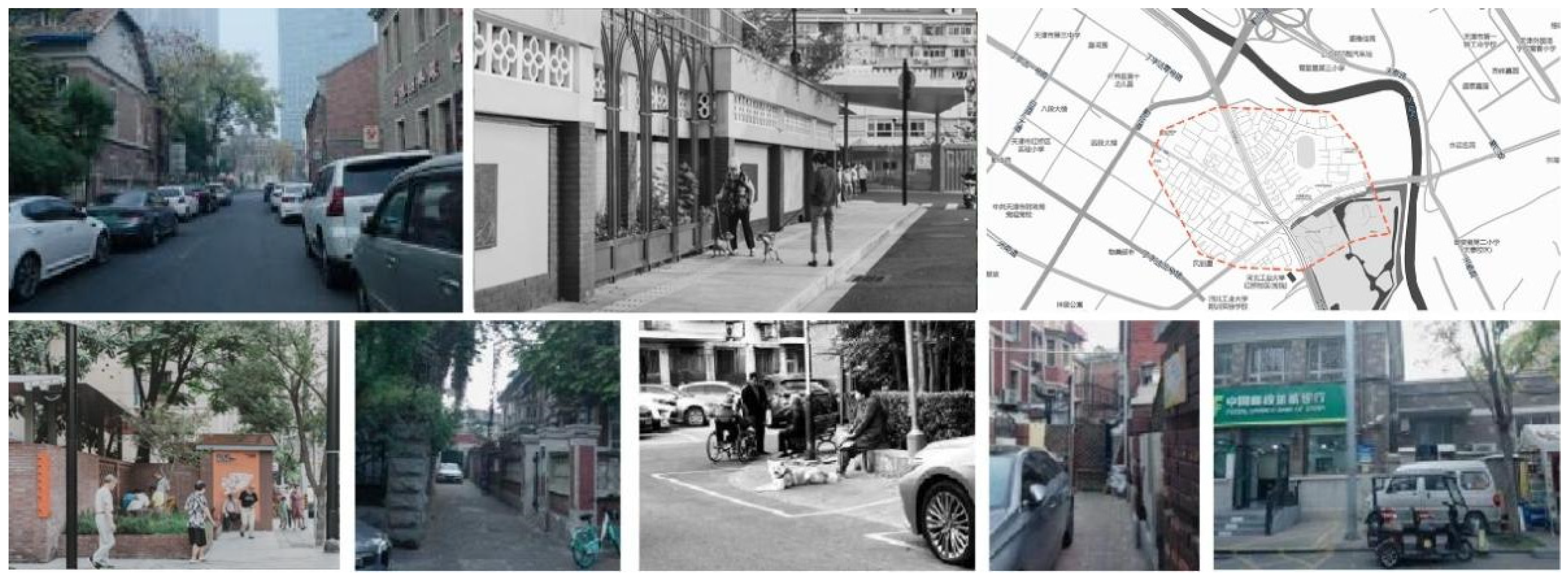
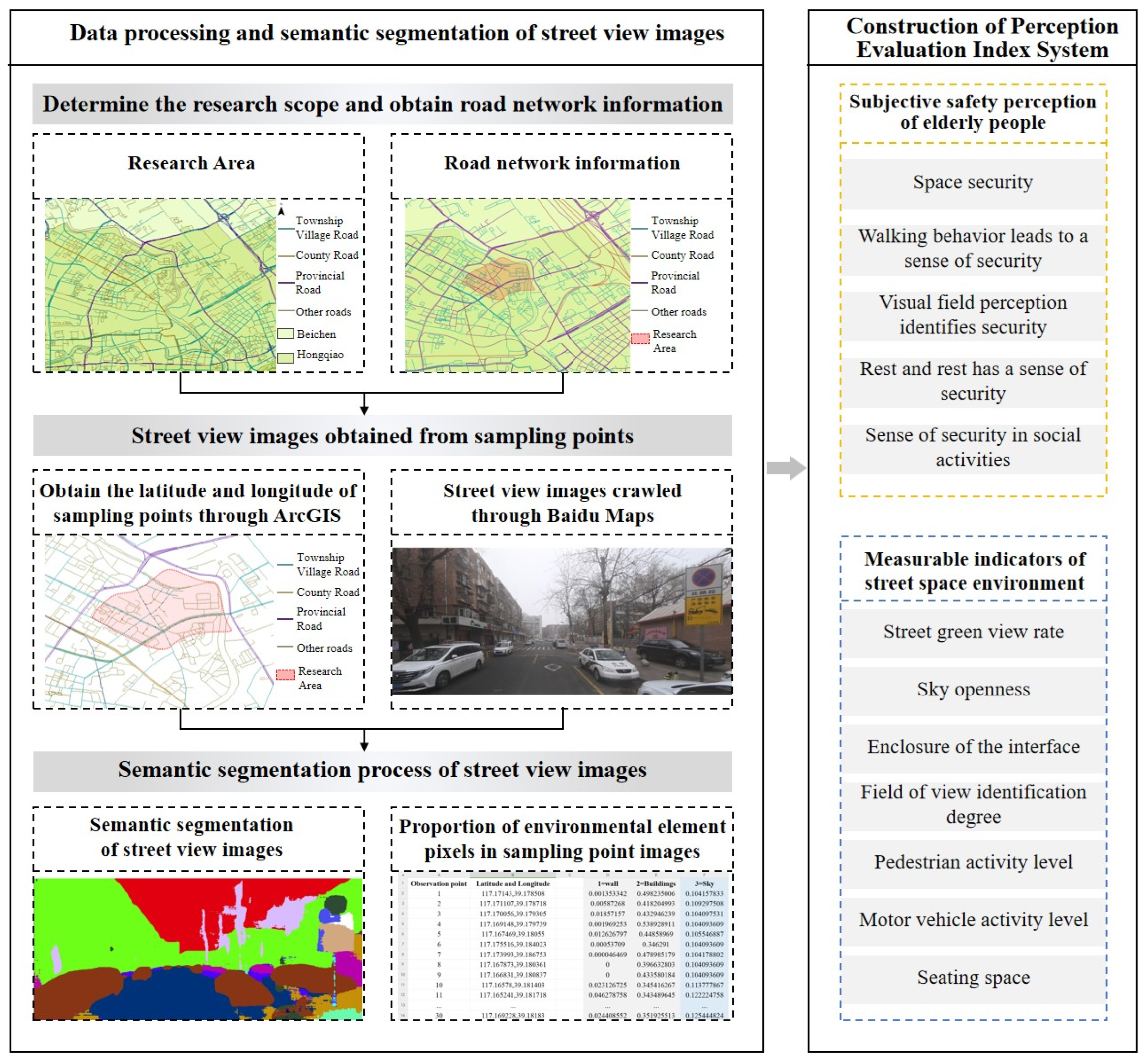
3.1. Research Area and Data Sources

Tianjin is one of the cities in China that experienced an aging society earlier, with a relatively high senior population, especially in the living street spaces in the main urban area of Tianjin. Due to the long construction period, small street scale, and few motor vehicles in the past, pedestrians occupy a dominant position in the street space, and large-scale public spaces are scarce and scattered. These living street spaces have become a paradise for people, especially seniors. Therefore, the living street space bears the function of part of the urban public space. Among them, Hongqiao District, as one of the six districts located in the core area of Tianjin, has a severe situation of rapid development and high degree of population aging (as shown in Figure 2).
Therefore, this study selects the T Community in Dingzigou Street, Hongqiao District, Tianjin, as the research object. The community is located at the intersection of Dingzi Valley Third Road and Qinjian Road, covering an area of 0.42 square kilometers and having more than 1200 households. The ratio of children, middle-aged people, and seniors in the community is about 1:6:3, and the resident population is mainly composed of middle-aged and senior individuals. According to statistics, by the end of 2023, the proportion of permanent seniors over 60 years old will reach 24.93%. This high proportion of seniors provides a typical sample for studying the safety perception of seniors in living street spaces, enabling us to better investigate and analyze the specific needs and psychological feelings of seniors in street spaces. In addition, the area has the typical characteristics of older communities, and the rich street space elements reflect the public space characteristics of traditional living streets, providing rich field data for research. This study will focus on this point and explore the impact of living street space on the sense of security of seniors.
The main types of data sources in this article include street view image data and the subjective ratings of seniors on the safety perception of the sample street view images. Among them, an evaluation system is used to construct environmental measurement indicators affecting spatial security, and sampling points are determined through road network data; street view data are used to extract street environment elements, and SD semantic analysis and Likert scale methods are adopted to determine the measurement indicators of street environment elements related to the subjective perception of seniors.

3.2. Research Framework

When conducting a comprehensive assessment of the living street spatial environment, we have established a systematic research framework to process and analyze relevant street spatial data. The following figure shows a research framework for evaluating the perceived safety of living street spaces using semantic segmentation techniques based on street view images (Figure 3).

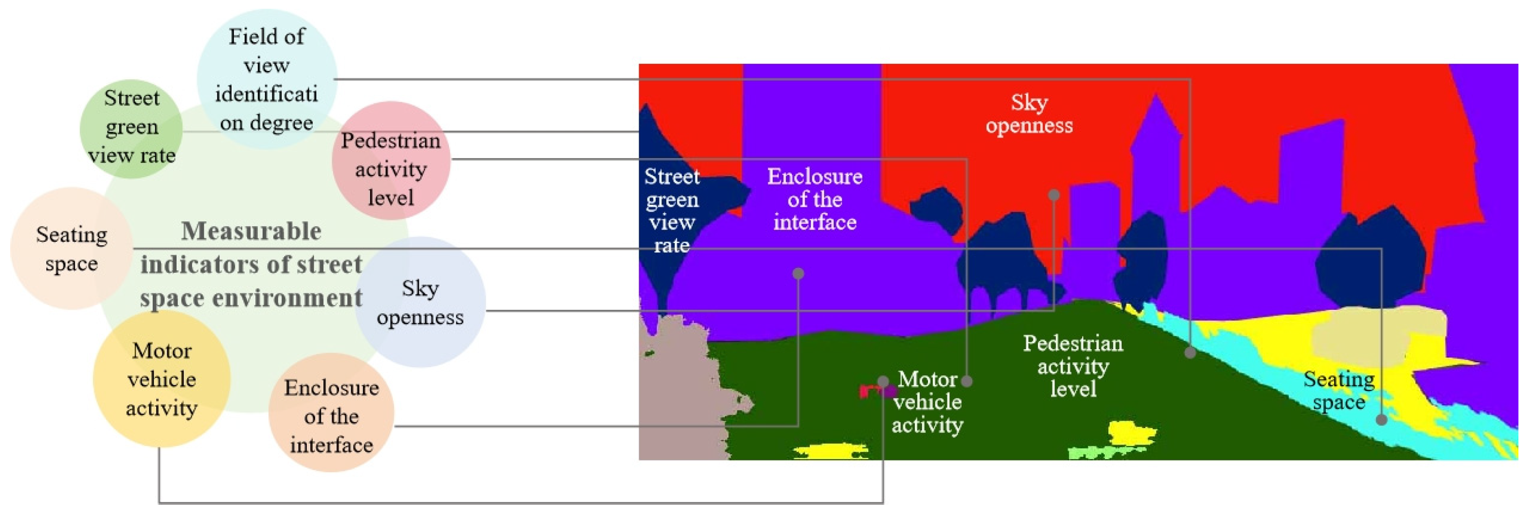
3.3. Measurable Indicators of Street Space Environment

The evaluation methods for healthy streets include street health evaluation tools and survey tools [22]. Han established the corresponding relationship between population health outcomes and street spatial elements based on three dimensions: physiological, psychological, and social health [23]. In this study, firstly, based on the characteristics of Tianjin’s urban living streets and the needs of senior users, a comprehensive evaluation system for street space is established. The evaluation tool is the indicator system, which mainly involves research from the dimensions of street space travel friendliness, street greening degree, pedestrian perceived safety, and experience of comfort [24,25]. This study starts from the dimension of security, including indicators such as green visibility, sky openness, interface enclosure, and pedestrian pavement smoothness of the street space. The study quantitatively evaluates the perception and age-friendly renewal effectiveness of the street space, and constructs a comprehensive street space evaluation system (Table 1, Figure 4).

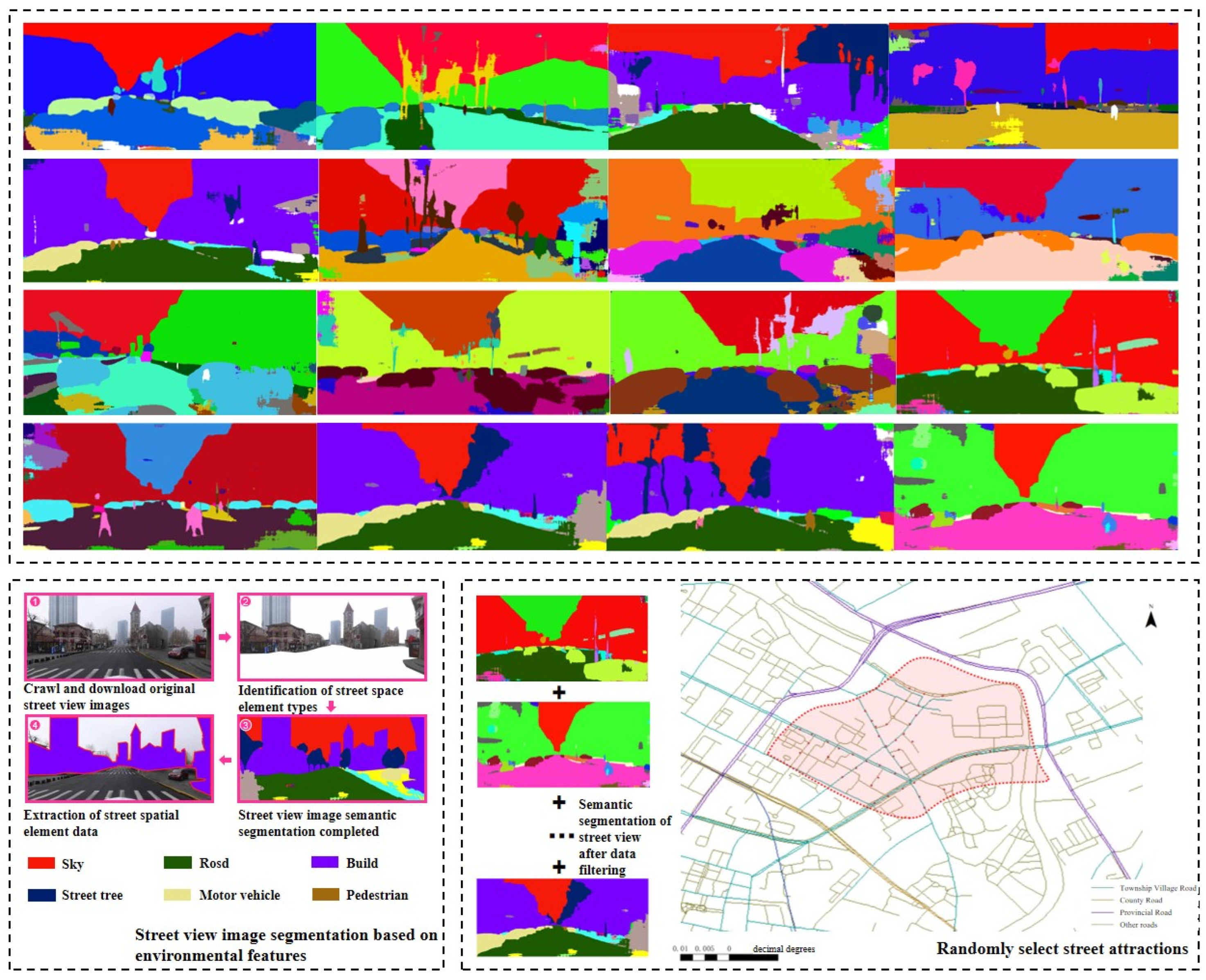
3.3.1. Data Collection and Measurement of Street Space Environmental Indicators Based on Street View Images

In order to more realistically study the factors influencing the sense of security from the environmental elements of living streets around the T Community, based on road network data, established sampling points at 50 m intervals on the streets mainly around Dingzigu Street. Through APIs, Baidu Street View images were obtained, and photos that were in the middle of the street and clear and bright were selected as much as possible. From a humanistic perspective, we can truly feel the differences in the street environment [26]. Therefore, we selected street scenes in four directions: 0°, 90°, 180°, and 270°, with a horizontal field of view of 180° and a vertical field of view of 0°. The image size is uniformly 1024 × 450 pixels. This research method covered the entire street section of the community, resulting in a total of 200 street view images to form a street view database. Next, the image is subjected to semantic segmentation using computer vision to calculate the recognition and measurement of street view elements. The semantic segmentation model used in this paper is the deep learning fully convolutional network FCN-8s [27] (which achieved segmentation accuracy of 81.44% and 66.84% in the training and testing datasets, respectively). It can perform semantic segmentation on 150 environmental elements in daily life. Figure 5 shows an example of the semantic segmentation of street view images and the process of collecting spatial element data.
Based on theoretical research on how the built environment [28] and the psychological state of seniors and their social interactions affect individuals’ behavior and perceptions, and considering the characteristics of visual elements and environmental factors that influence the walking behavior of older adults [6], the semantic segmentation of street view images resulted in the identification of 35 visual elements, including buildings, cars, sidewalks, grass, and shops, as objective environmental indicators.
At the beginning of this study, a wider range of street spatial environmental indicators were also selected. However, after screening and removing overly subjective measurement indicators, 30 easily recognizable environmental elements in living street spaces were ultimately selected and summarized into seven measurable objective environmental indicators (Table 2).
The quantitative cognitive and subjective perception evaluation system for lively street space environments based on street view images, with environmental elements related to safety perception in street spaces as the core measurement indicators, combines Baidu street view image data with the dimension of street space safety perception, constructing a measurement method that includes seven measurement indicators from two dimensions: the objective material spatial characteristics of the street and the subjective perception of the visual environment (Table 3).

3.3.2. Subjective Evaluation Data on the Sense of Safety in Streets Among Seniors

Referring to Maslow’s hierarchy of needs theory model and the physical and mental characteristics of senior groups [29], it is found that the basic needs of seniors follow a progressive pattern from physiological to psychological aspects. Based on this, in order to investigate the spatial security of seniors living on living streets in this study, the SD semantic analysis method was used to collect adjectives describing street security on the basis of overall spatial security, and different types of security were interpreted (Table 4). Combined with the evaluation criteria for street scene elements set in the questionnaire, factor and overall assessments were made on the street scene images, which further reflected seniors’ perception of safety in street spaces: (1) spatial sense of security, (2) sense of security during walking behavior, (3) sense of security in visual field perception, (4) sense of security during rest and relaxation, and (5) sense of security during social interaction activities (Figure 6).
Research evaluates the sense of security of seniors towards street space through quantitative and qualitative methods. In this study, a questionnaire was designed that includes background information and a security perception scale, with the former covering basic information such as age, gender, length of residence, monthly income, and education (Table 5). In the second part of the questionnaire, five types of adjectives describing the sense of security in living street spaces set by the SD semantic method were used as evaluation factors (Table 6). Using the Likert 5-point scale method [31], seniors could randomly score the street scene pictures: 1–5 (1 represents strongly disagree, 5 represents strongly agree). Referring to the research on the evaluation of urban perception using the human–machine adversarial scoring system constructed by Yao [27] et al., this evaluation method has been proven to be able to truly, effectively, and quickly assess the urban environment in small sample sizes [32,33] (20–30 people). Therefore, in this study, 40 questionnaires were collected within an 800 m radius of the T Community in Dingzigu Street, and 6 invalid questionnaires were screened out. Finally, 34 valid questionnaires were obtained, with a male to female ratio of 1:1 and an age range of 60–89 years old (standard deviation = 0.813).
The targeted analysis of various indicators of seniors’ perception of security was conducted, and the average score of each evaluation factor was calculated. According to the SD method, the results of each indicator were calculated, with each SD semantic adjective as the horizontal axis and the corresponding score of the indicator as the vertical axis, and an evaluation score curve graph was created (as shown in Figure 7). Based on the street view images, it can be seen that the average score for seniors’ evaluation of the sense of security in living street spaces is 3.02 points. Among them, the three indicators of perceived and recognized security in street spaces, sense of security during rest and relaxation, and sense of security in social activities are all above average, with perceived and recognized security in street spaces having the highest score, reaching 3.13. Spatial security in the street and sense of security during walking behavior are both below average, with the lowest score for sense of security during walking behavior (2.85).

4. Results

4.1. Reliability Verification

Firstly, a reliability test was conducted for the questionnaire (Table 7). The results indicate that the Cronbach’s alpha coefficient value is 0.710, which is greater than 0.7, indicating that the questionnaire’s questions have internal consistency and the data values are reliable for further analysis.

4.2. Model Establishment

4.2.1. Related Analysis: The Impact of Street Spatial Environment on Seniors’ Perception of Safety at All Levels

First, to more intuitively reflect the relationship between the objective street scene environmental factors and the overall sense of safety of seniors in street spaces, we adopted the Pearson correlation analysis method to quantify the relationship between the two. The study analyzed the correlation and significance between five types of safety perceptions of seniors in street spaces and objective street scene environmental measurement indicators separately (Table 8, Table 9, Table 10, Table 11 and Table 12).
As can be seen from Table 8, the variables significantly related to the sense of safety in the street space (p < 0.05) are “Street green view rate”, “Sky openness”, and “View identification degree”. Among these, the correlation coefficient for “Street green view rate” is positive, indicating a positive correlation with the sense of safety in street space whereas the correlation coefficients for “Sky openness” and “View identification degree” are negative, indicating a negative correlation with the sense of safety in the street space.
As can be seen from Table 9, the variables significantly related to the sense of security during walking behavior (p < 0.05) are “Street green view rate”, “Interface enclosure”, and “Motor vehicle activity”, among which the correlation coefficients for “Street green view rate” and “Motor vehicle activity” are positive, indicating a positive correlation with the sense of security during walking behavior. The correlation coefficient for “Interface enclosure” is negative, indicating a negative correlation with the sense of security during walking behavior.
As can be seen from Table 10, the variables significantly related to the perception of safety through visual identification (p < 0.05) are “Street green view rate” and “Interface enclosure”, and both have positive correlation coefficients, indicating a positive correlation with the perception of safety through visual identification.
As can be seen from Table 11 and Table 12, the relationship between objective street scene environmental measures and the sense of security during rest and relaxation, as well as the sense of security during social interactions, is not significant. This suggests that objective street scene environmental measures may have some impact on these two types of security for seniors, but this impact is not statistically significant enough.

4.2.2. Regression Analysis: The Impact of Perceived Safety at Various Levels on Overall Perceived Safety in Street Spaces

This study established an evaluation model based on the standardized values of the SD semantic analysis results for street view images, taking the overall safety perception of seniors for street space (Y) as the dependent variable, and the sense of spatial security (X1), sense of security during walking behavior (X2), sense of security in visual perception and identification (X3), sense of security during rest and relaxation (X4), and sense of security during social interaction activities (X5) as the independent variables. Multiple functional relationship models are constructed between the single dependent variable Y and the multiple independent variables X1, X2, X3, X4, and X5, respectively.
Y = B1 × X1 + B2 × X2 + B3 × X3 + B4 × X4 + B5 × X5 + β
Theorem 1. 
In the formula, B1 represents the regression coefficient value for spatial security, B2 is the regression coefficient value for the perception of safety during walking behavior, B3 is the regression coefficient value for safety in visual field security perception, B4 is the regression coefficient value for security during rest and relaxation, and B5 is the regression coefficient value for security during social interaction. The numerical value β: regression coefficient random error term = 0.045.
Through the results of the linear regression analysis (Table 13), we found that spatial security, sense of security during walking behavior, and sense of security in visual perception and identification have a significant impact on the cognitive sense of security among seniors. The sense of security during rest and relaxation and social activities does not have a significant impact. The VIF values indicate that all independent variables are within an acceptable range, suggesting that there is no issue of multicollinearity in the model. The model’s R2 and adjusted R2 values are 0.770 and 0.739, respectively, indicating a high degree of explanation for the data.

5. Discussion

Based on the results of the aforementioned study, we found that by combining the subjective evaluation results of seniors’ sense of safety in street spaces using the Likert scale method with the objective data obtained from semantic segmentation of street view elements to construct an evaluation system, the following was observed: according to the Pearson correlation results, in street view images, the green view rate of streets and the enclosure degree of interfaces show significant correlations with seniors’ perception of safety in street spaces. Among these, the green view rate is generally positively correlated with various safety scores, particularly in spatial safety (correlation coefficient = 0.303, p = 0.048) and visual perception identification safety (correlation coefficient = 0.387, p = 0.035). This suggests that the level of greening in streets could be a positive factor in enhancing seniors’ sense of safety in street spaces. This means that the level of greenery in the streets may be a positive factor that can enhance the sense of security in street spaces for seniors. By adding green belts and by arranging plant clusters and roadside trees reasonably, the length of time seniors stay in urban green spaces can be increased. In addition, the Green View Index (GVI) of a street, as an indicator of the level of street greening, directly affects the visual experience and attractiveness of the street space. Improving the quality of street greening can significantly enhance visual comfort for the public, which is particularly important for environmentally sensitive groups, especially seniors [34]. In addition, research has shown that improving the visual environment characteristics of street spaces, such as increasing the greening and openness of streets, can directly affect residents’ environmental perception during physical exercise, alleviate tension and anxiety, and have a significant positive effect on increasing outdoor activity participation among seniors and other groups [35]. The enclosure degree of interfaces shows significant correlations with perceived safety during walking behavior (correlation coefficient = −0.221, p = 0.024) and visual perception identification safety (correlation coefficient = 0.349, p = 0.018), indicating that a moderate sense of enclosure may have a positive impact on seniors’ sense of safety. However, excessively enclosed spaces may have a negative impact on perceived safety during walking. Jan Gehl, in books such as Communication and Space (2004) and Humanized Cities (2010), deeply analyzes the sense of enclosure from the perspective of people’s psychological needs and activity types [36] in the streets, pointing out that the sense of enclosure in urban and architectural spaces is closely related to people’s social interactions and indicating that vibrant street spaces should first meet the three basic psychological needs of space users, namely, safety, convenience, and comfort. In the book Public Space and Public Life—Copenhagen 1996 (2003) [37], Copenhagen was used as an example to study the sense of enclosure in various public spaces in the city. The study showed that through the combination of elements such as architecture and greenery, as well as the relationship between different building heights, street widths, and building spacing and enclosure, narrow streets and tall buildings may create a strong sense of enclosure. For example, buildings that are too high or too low can reduce the quality of street spaces [38], and can also cause a sense of visual closure, making seniors feel psychologically oppressed. Other street view environmental elements did not show very significant correlations with seniors’ perception of safety across different dimensions.
Based on the results of the linear regression, the overall safety perception of seniors in street spaces showed a significant correlation with spatial safety perception, walking behavior, and visual safety perception. This indicates that, in street space planning, priority should be given to the planning of the walking environment for seniors, especially in the neighborhood building environment (NBE), which is the main place in which seniors engage in outdoor activity (OA) [39]. Improving the walking system of the street, adding clear signage systems, and implementing pedestrian and vehicle separation measures can help improve the accessibility and safety of the walking environment and promote the utilization rate of community public spaces. However, there is no significant correlation between the sense of security during rest and social activities and the perception of security among seniors. This may indicate that although these factors have an impact on the daily life of seniors, their contribution to overall security is relatively small. This indicates that in the senior population, outdoor rest and relaxation occupy relatively less time in daily life, and people usually only take a break near familiar homes [40]. Research has shown that the improvement of the material environment in streets is best combined with social intervention, designing clear and understandable signage systems, and increasing comfortable walking facilities for seniors or people with mobility impairments in order to maintain the connection between seniors and the community and help enhance their self-identity in the spatial environment [41]. Moreover, due to the lack of significant characteristics in the sense of security in social behavior among seniors in street spaces, based on data and the behavior of seniors, it can be inferred that seniors have very high requirements for the quality of the spatial environment in which social behavior occurs due to their decreased physical function and psychological characteristics. The quality of the spatial environment can directly affect the safety of space use and the sustainability of social activities for seniors [42]. Therefore, when creating social spaces for seniors, attention should be paid to improving the quality of the spatial environment, such as adding seats on the streets and adjusting them according to ergonomic scales, and providing shading facilities, public art installations, etc., to provide more social and resting space for seniors.
Through this experimental study, we have gained a deeper understanding of the sense of security of seniors in street spaces. Reading articles by professors such as Xu Leiqing [43], Fang Zhiguo [44], and Wei Yue [45] on street scenes has greatly broadened our knowledge in this area of research. Referring to Ann Sussman’s in-depth study of people’s perception of the building environment [46], eye tracking technology can reveal people’s visual reactions to building facades and accurately capture detailed data such as gaze points and gaze duration when observing street environments. Currently, in street spaces, elements such as traffic signs, pedestrians, and shop signs are often the focus of people’s attention. Future research will also focus on the impact of street environment elements on the psychological perception of seniors based on street view image data of living street spaces, helping to further explore their positive or negative effects on the safety perception of seniors. Combining the experimental results, we have broken through the limitations of Dingzigu Street and proposed some suggestions for enhancing the sense of security of seniors in street spaces. Future research can further explore ways to optimize these environmental factors through specific spatial design interventions to better meet the needs of seniors.

6. Conclusions

Due to limitations such as personal capabilities, time constraints, and experimental conditions, this study has several limitations, and future research needs to further deepen and expand the knowledge in the following areas.
(1)
In terms of data source processing
In this study, a combination of objective and subjective methods was used. Cutting-edge ArcGIS 10.8 and data-scraping software (Baidu Static Panorama API, GOOGLE Maps) and semantic segmentation technology (LABELME, Smart Umbrella Cloud) were used to obtain objective data, replacing traditional manual measurements and on-site surveys, greatly improving the efficiency and accuracy of data collection. However, future research could explore additional data sources and collection methods to further enhance the comprehensiveness and representativeness of the data. For instance, incorporating data from other cities or regions could provide a more diverse perspective on the relationship between street view environmental indicators and the spatial safety perceptions of seniors.
(2)
In terms of analysis results
This study explores the association between seniors’ perception of safety in street spaces and the environmental elements of the street. Seven key environmental indicators were selected for analysis, but research on the impact of other environmental elements is still at a basic stage and is limited. The data collection was limited to Dingzigu Street in Tianjin and may not represent other areas as a single and one-sided data source; in subjective evaluations, some senior individuals may have poor cooperation, potentially leading to sample bias. Future research needs to expand the scope of research and conduct in-depth analyses of more environmental factors in street spaces that affect seniors’ perceptions of safety. We will also combine virtual reality technology to build street space scenes to invite seniors to experience space, and analyze and study them.
(3)
At the level of optimization strategies
This study relies on urban planning concepts and proposes a series of targeted improvement measures for key dimensions such as green landscapes, building interfaces, street facilities, and traffic elements in living street spaces. However, the quality improvement of living streets is a complex process involving multiple dimensions and levels, with diverse needs among residents of different streets.
Therefore, future research needs to conduct case studies in different types of communities based on the specific spatial, environmental, and facility characteristics and requirements of different streets, conduct more refined research work at a more microscopic level, and develop more accurate optimization strategies. At the same time, it is recommended that the research results of gerontology, geographic information science, public health, and other interdisciplinary fields are integrated into the practice of optimizing street spaces to form a multidisciplinary research framework for comprehensively improving the quality of street spaces and to create a safer and more comfortable living environment for the senior population.

Author Contributions

Conceptualization, X.S., X.N. and Z.H.; methodology, X.N. and Z.H.; software, X.N.; validation, X.S., X.N. and Z.H.; formal analysis, X.N. and Z.H.; investigation, X.N. and Z.H.; resources, X.S.; data curation, X.N. and Z.H.; writing—original draft preparation, X.N. and Z.H.; writing—review and editing, X.S., X.N. and R.T.; visualization, X.N.; supervision, X.S.; project administration, X.S. and L.W. All authors have read and agreed to the published version of the manuscript.

Funding

This research was supported by the Cultural & Artistic Scientific Planning and Tourism Research Project of Hebei Province, China [Grant Number: HB24-QN047]: Research on the Spatial Aging Renewal of Historical and Cultural Blocks based on the Data of Street View Image from the Perspective of Healing. In addition to this, we are deeply indebted to the seniors who participated in the research for their patient and enthusiastic participation.

Data Availability Statement

The original contributions presented in the study are included in the article, further inquiries can be directed to corresponding authors.

Conflicts of Interest

The authors declare no conflicts of interest.

References

  1. Porzi, L.; Rota Bulò, S.; Lepri, B.; Ricci, E. Predicting and Understanding Urban Perception with Convolutional Neural Networks. In Proceedings of the 23rd ACM International Conference on Multimedia, Brisbane, Australia, 26–30 October 2015; ACM: New York, NY, USA, 2015; pp. 139–148. [Google Scholar]
  2. Seiferling, I.; Naik, N.; Ratti, C.; Proulx, R. Green streets—Quantifying and mapping urban trees with street-level imagery and computer vision. Landsc. Urban Plan. 2017, 165, 93–101. [Google Scholar] [CrossRef]
  3. Zhang, L.; Pei, T.; Wang, X.; Wu, M.; Song, C.; Guo, S.; Chen, Y. Quantifying the Urban Visual Perception of Chinese Traditional-Style Building with Street View Images. Appl. Sci. 2020, 10, 5963. [Google Scholar] [CrossRef]
  4. Newman, O. Defensible Space; Macmillan: New York, NY, USA, 1972. [Google Scholar]
  5. Zhang, Y.; Lin, Q.; Zhu, C.; Mao, M.; Jiang, D. The influence of permeable environment on the distribution of theft crimes and the moderating role of social disorganization: Also on the applicability of the street-eye theory and the defensive space theory. Adv. Geogr. Sci. 2022, 41, 1041–1052. [Google Scholar]
  6. Jacobs, J. The Death and Life of Great American Cities; Yilin Press: Nanjing, China, 2006. [Google Scholar]
  7. Meng, L.; Wen, K.-H.; Zeng, Z.; Brewin, R.; Fan, X.; Wu, Q. The Impact of Street Space Perception Factors on Elderly Health in High-Density Cities in Macau—Analysis Based on Street View Images and Deep Learning Technology. Sustainability 2020, 12, 1799. [Google Scholar] [CrossRef]
  8. Zeng, Y.; Chen, B. Evaluation of Aging-Friendly Public Spaces in Old Urban Communities Based on IPA Method—A Case Study of Shouyi Community in Wuhan. Buildings 2024, 14, 2362. [Google Scholar] [CrossRef]
  9. New York Department of Transportation. Safe Streets for the Elderly; New York Department of Transportation: New York, NY, USA, 2024. [Google Scholar]
  10. Li, H.; Chen, C.; Liu, X.; Wu, Y.; Chen, S. Spatial Distribution Characteristics and Influencing Factors of Age-friendly Urban Streets Based on Human-centered Streetview Images. J. Geo-Inf. Sci. 2024, 26, 1469–1485. [Google Scholar]
  11. Chen, L.; Xu, J.; Zhang, W.; Xie, Y.; Dang, Y.; Zhan, D. Residents’ perception of urban public safety and community environment: An analysis based on a large-scale questionnaire survey in Beijing. Acta Geogr. Sin. 2021, 76, 1939–1950. [Google Scholar]
  12. Zhang, L.; Wang, X. Accurate Object Recognition in Street View Images Using Convolutional Neural Networks. J. Comput. Vis. Pattern Recognit. 2023, 45, 123–135. [Google Scholar] [CrossRef]
  13. Li, M.; Liu, Z.; Chen, H. Prediction of Traffic Flow and Pedestrian Movement Patterns Based on Convolutional Neural Networks. IEEE Trans. Intell. Transp. Syst. 2024, 15, 879–890. [Google Scholar]
  14. Wang, J.; Zhang, Y. Analysis of the Impact of Environmental Factors on Resident Well-being Using Convolutional Neural Networks. Environ. Sci. Technol. 2024, 58, 4567–4575. [Google Scholar]
  15. Huang, W.K.; Teng, F.; Wang, Z.D. A review of image segmentation based on deep learning. Comput. Sci. 2024, 51, 107–116. [Google Scholar]
  16. Gao, L.; Xiang, X.; Chen, W.; Nong, R.; Zhang, Q.; Chen, X.; Chen, Y. Research on Urban Street Spatial Quality Based on Street View Image Segmentation. Sustainability 2024, 16, 7184. [Google Scholar] [CrossRef]
  17. Pan, Z.; Liu, Y.; Liu, Y.; Huo, Z.; Han, W. Age-friendly neighborhood environment, functional abilities and life satisfaction: A longitudinal analysis of older adults in urban China. Soc. Sci. Med. 2024, 340, 116403. [Google Scholar] [CrossRef]
  18. Beatley, T. Biophilic Cities: Integrating Nature into Urban Design and Planning; Island Press: Washington, DC, USA, 2011. [Google Scholar]
  19. Alexander, C. A Pattern Language: Towns, Buildings, Construction; Oxford University Press: Oxford, UK, 1977. [Google Scholar]
  20. Lu, J.; Liu, P.; Wu, X. Christopher Alexander’s ‘Pattern Language’ and Its Influence in the Field of Computer Science. Stud. Dialectics Nat. 2012, 11, 104–109. [Google Scholar]
  21. Sussman, A.; Hollander, J. Cognitive Architecture: Designing for How We Respond to the Built Environment, 2nd ed.; Routledge: London, UK, 2021. [Google Scholar]
  22. Shu, S.; Chen, G.; Ma, R.; Gao, S. Pedestrian and Bicycle Traffic Enhancement Strategies Based on the Concept of Healthy Streets: A Case Study of Wangfujing Area, Beijing. Urban Transp. 2022, 20, 75–84. [Google Scholar]
  23. Han, X. Research on the implementation-oriented strategy for improving healthy streets: Taking the public space improvement design of Jianhua South Road Street in Beijing as an example. Huazhong Archit. 2024, 42, 131–136. [Google Scholar]
  24. Sun, T.; Fan, L.; Wei, X. Lessons from London’s Healthy Street Planning Experience. Planners 2020, 36, 80–86. [Google Scholar]
  25. Wei, H. Shaping Healthy Cities with Healthy Street Approaches: Insights from the Healthy Streets Policy of Greater London. Urban Transp. 2021, 19, 1–10. [Google Scholar]
  26. Liu, L.; Tu, Y.; Sun, M.; Lyu, H.; Wang, P.; He, J. Spatial Quality Measurement and Characterization of Daily High-Frequency Pedestrian Streets in Xi’an City. Land 2024, 13, 885. [Google Scholar] [CrossRef]
  27. Yao, Y.; Liang, Z.; Yuan, Z.; Liu, P.; Bie, Y.; Zhang, J.; Wang, R.; Wang, J. A Human-Machine Adversarial Scoring Framework for Urban Perception Assessment Using Street-View Images. Int. J. Geogr. Inf. Sci. 2019, 33, 2363–2384. [Google Scholar] [CrossRef]
  28. Wang, Q. A Study on the Influence of Built Environment, Psychological State, and Social Interaction on the Leisure Walking Intention of Elderly People; Taiyuan University of Science and Technology: Taiyuan, China, 2024. [Google Scholar]
  29. Yao, J. Reflections on Modern Community Planning and Design under Maslow’s Hierarchy of Needs. Planner 2015, 31, 140–144. [Google Scholar]
  30. Maslow, A.H. A theory of human motivation. Psychol. Rev. 1943, 50, 370–396. [Google Scholar] [CrossRef]
  31. Qi, L. Statistical analysis of the Likert scale and fuzzy comprehensive evaluation. Shandong Sci. 2006, 2, 18–23+28. [Google Scholar]
  32. Yao, Y.; Wang, J.L.; Hong, Y.; Qian, C.; Guan, Q.; Liang, X.; Dai, L.; Zhang, J. Discovering the homogeneous geographic domain of human perceptions from street view images. Landsc. Urban Plan. 2021, 212, 104125. [Google Scholar] [CrossRef]
  33. Wang, R.Y.; Liu, Y.; Lu, Y.; Yuan, Y.; Zhang, J.; Liu, P.; Yao, Y. The linkage between the perception of neighbourhood and physical activity in Guangzhou, China: Using street view imagery with deep learning techniques. Int. J. Health Geogr. 2019, 18, 18. [Google Scholar] [CrossRef]
  34. Sun, D.; Ji, X.; Gao, W.; Zhou, F.; Yu, Y.; Meng, Y.; Yang, M.; Lin, J.; Lyu, M. The Relation between Green Visual Index and Visual Comfort in Qingdao Coastal Streets. Buildings 2023, 13, 457. [Google Scholar] [CrossRef]
  35. Zhu, J.; Li, B.; Ouyang, H.; Wang, Y.; Bai, Z. Understanding Urban Residents’ Walking Exercise Preferences: An Empirical Study Using Street View Images and Trajectory Data. Buildings 2024, 14, 549. [Google Scholar] [CrossRef]
  36. Gehl, J. Places for People: Meboume; City of Meboume: Melbourne, Australia, 2004. [Google Scholar]
  37. Gehl, J.; Gemzoe, L. Public Spaces, Public Life; Tang, Y., Translator; China Architecture & Building Press: Beijing, China, 2003. [Google Scholar]
  38. Zhou, L.; Hu, J.; Liu, Y. The Impact of Outdoor Activity Spaces in Hainan Communities on the Health Perception of seniors. Urban For. China 2022, 20, 42–47. [Google Scholar]
  39. Guo, N.; Xia, F.; Yu, S. Enhancing Elderly Well-Being: Exploring Interactions between Neighborhood-Built Environment and Outdoor Activities in Old Urban Area. Buildings 2024, 14, 2845. [Google Scholar] [CrossRef]
  40. Wang, Z. Research on Community Livability Street Renewal Strategies Based on Emotion Perception; North China University of Technology: Beijing, China, 2024. [Google Scholar]
  41. Lu, M.; Zhang, Y.; Liu, X.; Bai, Z. Research on Urban Residents’ Safety Psychological Perception from the Perspective of Community Public Space Safety. Mod. Urban Res. 2019, 8, 125–130. [Google Scholar]
  42. Witten, K.; Macmillan, A.; Mackie, H.; van der Werf, B.; Smith, M.; Field, A.; Woodward, A.; Hosking, J. Te Ara Mua—Future Streets: Can a streetscape upgrade designed to increase active travel change residents’ perceptions of neighborhood safety, well-being. Space Soc. 2022, 3, 100079. [Google Scholar] [CrossRef]
  43. Xu, L.; Jiang, W.; Chen, Z. Study on the sense of security in public spaces: A case study of urban street scene perception in Shanghai. Landsc. Archit. 2018, 25, 23–29. [Google Scholar]
  44. Fang, Z.; Wang, R.; Liu, C. Research on the Impact of Street Environment on Individual Sense of Security Based on Multi-source Data. J. Shanghai Urban Plan. Rev. 2023, 2, 109–115. [Google Scholar]
  45. Wei, Y.; Yang, D. Evaluation on the Built Environment Support for the Neighborhood Destinations of the Elderly’s Daily Activities: A Case Study of Dalian City. City Plan. Rev. 2024, 48, 59–71. [Google Scholar]
  46. Sussman, A. Using Eye Tracking to Reveal Responses to the Built Environment and Its Constituents. Appl. Sci. 2023, 13, 12071. [Google Scholar] [CrossRef]
Figure 1. Current situation of living street space (author’s own photographs).
Buildings 14 03973 g001
Figure 2. Research scope (author’s own representation). (a) Research scope: Proportion of elderly population (aged 60 and above); (b) Research scope and road network situation in surrounding areas.
Buildings 14 03973 g002
Figure 3. Technical road map of street view image semantic segmentation (author’s own representation).
Buildings 14 03973 g003
Figure 4. Schematic diagram of measurable indicators for street space environment (author’s own representation).
Buildings 14 03973 g004
Figure 5. Semantic segmentation of street view images and spatial feature data collection process (author’s own representation).
Buildings 14 03973 g005
Figure 6. Seniors’ perception of street space safety based on Maslow’s hierarchy of needs theory (top image obtained from Abraham Maslow’s 1943 work The Theory of Human Motivation [30]; bottom picture created by the author).
Buildings 14 03973 g006
Figure 7. Score curve graph of street space safety perception evaluation based on SD semantic analysis method (author’s own representation).
Buildings 14 03973 g007
Table 1. Construction of measurable street space environmental indicators.
Application DimensionMeasurement IndexIndex InterpretationMeasure Method
Measurable indicators of street space environmentStreet green view rateThe green space area perceived by pedestrians in street space.Percentage of pixel area of landscape greening elements in street view images.
Sky opennessThe area of the sky visible to pedestrians in street space.Percentage of pixel area of sky elements in street view images.
Enclosure of the interfaceThe enclosed feeling formed in street space.Percentage of pixel area of buildings and structures in street view images.
Field of view identification degreeDirectional signage system within street spaces.The pixel area proportion of elements such as traffic signs, traffic lights, etc., in street view images.
Pedestrian activity levelFrequency of pedestrians appearing in street spaces.Percentage of pedestrian pixel area in street view images.
Motor vehicle activityArea of motor vehicles in street space.Percentage of pixel area of motor vehicles in street view images.
Seating spaceThe space that can be sat in formed in the street space.Percentage of pixel area of rest space elements in street view images.
Table 2. Classification of street environmental elements.
Measurement IndexStreet View ElementsIndicator Project
Street green view ratePlantsTrees; Grass; Plants
Sky opennessSkySky
Enclosure of the interfaceEnclosure by buildings and structuresWalls; Buildings; Ground; Fences
Field of view identification degreeDirectional signage facilities and systemsPosts; Shop signs; Trademarks; Street lights; Poles; Sculptures; Traffic lights; Monitors; Flags
Pedestrian activity levelNon-motorized vehicleRoads; Sidewalks; Pedestrians; Animals
Motor vehicle activityMotor vehicleCars; Buses; Trucks; Vans; Small locomotives; Steps; Bicycles; Railways
Seating spaceSeating spaceSeats
Street imaginabilityThe uniqueness, recognizability, and impressive level of street spaceArtificial audit element: Subjective scoring of street view images using expert scoring methods. The measurement results are subjective and will not be considered for the time being
Pedestrian pavement smoothnessDegree of completeness of pedestrian rights of way
Cleanliness of pedestrian interfaceThe degree of old, damaged, and chaotic building facades and floors
Coordination of street facilitiesThe coordination level of basic public facilities such as street facilities, isolation facilities, and cycling road networks
Table 3. Quantitative measurement method for liveliness of street space environment based on street view image data.
Application DimensionMeasurement IndexIndex InterpretationMeasure Method
Measurable indicators of street space environmentStreet green view rateThe green space area perceived by pedestrians in street spacePercentage of pixel area of landscape greening elements in street view images S p l a n t + S g r a s s + S t r e e S t o t a l
Sky opennessThe area of the sky visible to pedestrians in street spacePercentage of pixel area of sky elements in street view images S s k y S t o t a l
Enclosure of the interfaceThe enclosed feeling formed in street spacePercentage of pixel area of buildings and structures in street view images S b u i l i n g s + S s t r u c t u r e s S t o t a l
Field of view identification degreeDirectional signage system within street spacesThe pixel area proportion of elements such as traffic signs, traffic lights, etc., in street view images S t r a f f i c   s i g n s + S t r a f f i c   l i g h t s e s + S t o t a l
Pedestrian activity levelFrequency of pedestrians appearing in street spacesPercentage of pedestrian pixel area in street view images S p e d e s t r i a n s S t o t a l
Motor vehicle activityArea of motor vehicles in street spacePercentage of pixel area of motor vehicles in street view images S m o t o r   v e h i c l e s S t o t a l
Seating spaceThe space that can be sat in formed in the street spacePercentage of pixel area of rest space elements in street view images S s e a t s S t o t a l
Table 4. Interpretation of five security perception indicators based on SD semantic analysis.
Five Different Types of Security PerceptionInterpretation of Indicators
Sense of spatial securityThe perception of seniors feeling comfortable, safe, and relaxed in street spaces, for example, carefully designed street layouts and clear spatial boundaries.
Sense of security during walking behaviorIt will affect the willingness and safety level of seniors to walk in the street space. This is related to factors such as street environment and traffic conditions.
Sense of security in visual perception and identificationIt affects the visual recognition and assessment of the safety of the street environment by seniors in the street space, such as the visibility of the logo and the clarity of the field of view.
Sense of security during rest and relaxationIt will affect seniors’ choice of resting place, reflecting their need for a safe and comfortable resting place on the street.
Sense of security during social interaction activitiesIt reflects the sense of security that seniors feel when engaging in social activities in street spaces. A good street space environment can directly affect the safety of space use and the sustainability of social activities.
Table 5. Statistical results from questionnaire regarding personal background information of seniors.
SubjectOptionsFrequencyPercentage (%)Cumulative Percentage (%)
Age60–69 years old823.5323.53
70–79 years old2058.8282.35
80 years old and above 6 17.65 100
GenderFemale1852.9452.94
Male 16 47.06 100
Duration of residence in this community1–3 years12.942.94
More than 3 years12.945.88
3–10 years617.6523.53
10–30 years2058.8282.35
Over 30 years 6 17.65 100
Highest education levelElementary school and below720.5920.59
Junior high school1441.1861.76
High school/vocational school1132.3594.12
College/Bachelor’s degree 2 5.88 100
Personal monthly incomenothing38.828.82
Less than CNY 2000 926.4735.29
CNY 2000–4000823.5358.82
CNY 4001–60001029.4188.24
CNY 6001–800038.8297.06
CNY 8001–10,000 1 2.94 100
Total 34 100 100
Table 6. Results for seniors’ different safety perceptions of street space based on SD semantic analysis method (The table with added background colors represents indicators that have a significant impact on the overall sense of security of seniors in street spaces, and the color depth represents the degree of influence).
Adjectives Describing Sense of Security in Street SpacesAverage Score
Spatial security2.962
Sense of security during walking behavior2.850
Sense of security in visual field perception3.126
Sense of security during rest and relaxation3.124
Sense of security in social interactions3.023
Average score of perceived safety in street spaces3.017
Table 7. Reliability analysis of five different types of security and overall sense of security for seniors in street spaces.
Cronbach Confidence Analysis
Number of TermsSample SizeCronbach’s α Coefficient
5340.71
Table 8. Pearson correlation analysis between objective street scene environmental measurement indicators and spatial sense of security (The table with added background colors represents measurable environmental indicators that have a significant impact on spatial security in street spaces).
Pearson Correlation Analysis
Measurable Indicators of Street Space EnvironmentSpace Security Score
Correlation Coefficientp-Value
Street green view rate0.3030.048 *
Sky openness−0.4810.037 *
Enclosure of the interface0.3180.086
Field of view identification degree−0.1370.037 *
Pedestrian activity level−0.0210.913
Motor vehicle activity−0.2910.241
Seating space0.0170.931
* p < 0.05.
Table 9. Pearson correlation analysis between objective street environment measurement indicators and sense of security during walking behavior (The table with added background colors represents measurable environmental indicators that have a significant impact on the sense of security during walking behavior in street space).
Pearson Correlation Analysis
Measurable Indicators of Street Space EnvironmentSafety Score for Walking Behavior
Correlation Coefficientp-Value
Street green view rate0.1620.039 *
Sky openness−0.1180.535
Enclosure of the interface−0.2210.024 *
Field of view identification degree−0.0060.975
Pedestrian activity level0.0490.798
Motor vehicle activity0.1810.048 *
Seating space0.0090.964
* p < 0.05.
Table 13. Linear regression results of seniors’ perception of five different types of safety (X1–5) in street spaces and overall safety (Y) (The table with added background colors indicates that different types of safety perceptions have a significant impact on the overall safety perception of seniors in street spaces, and the color depth represents the degree of influence).
Results of the Linear Regression Analysis (n = 34)
Non-Standardized CoefficientsStandardization Coefficienttp95%CIVIF
BStandard ErrorBeta
Constant0.0450.174-0.2570.799−0.297~0.386-
Spatial security0.4590.1450.4443.1720.003 **0.176~0.7432.557
Sense of security during walking behavior 0.5670.1320.5654.3020.001 **0.309~0.8252.249
Sense of security in visual field perception −0.3850.118−0.037−0.3210.002 *−0.269~0.1931.744
Sense of security during rest and relaxation−0.0590.126−0.058−0.4680.643−0.306~0.1882.029
Sense of security in social activities−0.070.1360.324−0.2780.611−0.306~0.1882.01
* p < 0.05, ** p < 0.01. Note: dependent variable (Y) = overall security in street space B: regression coefficient value (p-value < 0.05 significant). t: used to calculate p-value.
Table 10. Pearson correlation analysis between objective environmental measurement indicators of streetscapes and perceived sense of security in visual field perception (The table with added background colors represents measurable environmental indicators that have a significant impact on the perception of safety through visual identification in street space).
Pearson Correlation Analysis
Measurable Indicators of Street Space EnvironmentSafety Score for Visual Field Perception and Identification
Correlation Coefficientp-Value
Street green view rate0.3870.035 *
Sky openness0.2480.285
Enclosure of the interface0.3490.018 *
Field of view identification degree−0.0780.680
Pedestrian activity level0.0150.937
Motor vehicle activity0.2410.200
Seating space−0.1090.568
* p < 0.05.
Table 11. Pearson correlation analysis between objective environmental measurement indicators of streetscapes and perceived safety during rest stops.
Pearson Correlation Analysis
Measurable Indicators of Street Space EnvironmentRest and Relaxation Safety Score
Correlation Coefficientp-Value
Street green view rate0.0270.190
Sky openness0.0620.069
Enclosure of the interface−0.2140.264
Field of view identification degree0.1620.400
Pedestrian activity level0.2650.164
Motor vehicle activity0.1740.367
Seating space−0.1480.443
Table 12. Pearson correlation analysis between objective street scene environmental measurement indicators and the sense of security in social interactions.
Pearson Correlation Analysis
Measurable Indicators of Street Space EnvironmentSecurity in Social Activities Score
Correlation Coefficientp-Value
Street green view rate0.1130.560
Sky openness−0.3570.057
Enclosure of the interface−0.0580.766
Field of view identification degree0.1840.340
Pedestrian activity level0.1910.321
Motor vehicle activity−0.1120.563
Seating space−0.1520.430
Disclaimer/Publisher’s Note: The statements, opinions and data contained in all publications are solely those of the individual author(s) and contributor(s) and not of MDPI and/or the editor(s). MDPI and/or the editor(s) disclaim responsibility for any injury to people or property resulting from any ideas, methods, instructions or products referred to in the content.

