1. Introduction
The principle of quality work in civil engineering is to go through all of the activities of architects, engineers, urban planners, and other professionals in the creation of project documentation, so that throughout the activities—from the feasibility work to the implementation and management of the realised work—relevant documents, data, and outputs, whether in numerical or graphical form, are available. Each design activity and its outputs are a source, another input, or part of a spatial object or set of objects in the engineering activity. In digital design processes, the final output can thus become the initial output. If we have these digital files in archives, such output is an effective resource for new 3D design.
The goal of dynamic engineering work is to transform the design and implementation of a transportation project into intelligent, paperless, 3D electronic outputs [
1]. However, this activity is time-, teamwork-, and finance-intensive, and such a transition of design activity poses significant challenges that require synergies not only in private design organisations, but also on the side of public institutions.
How to embed these activities in the land-use plan and the extensive traffic engineering and planning activities? The city of Bratislava, in creating its new centre, has this challenge ahead of it [
2]. There are many successful examples of the use of BIM in vertical environments in Slovakia—especially buildings and their structures—but there are far fewer examples of the use of BIM in linear structures in the horizontal environment of our transport infrastructure [
3,
4]. A couple of bridges and preparations for motorway tunnels and motorway sections have been implemented in BIM, mainly because the tender required it, where international teams were involved. The requirements of public investors for motorways and railways are well known [
5]. However, due to the high cost of complex digital project documentation for the benefit of construction management and administration, these are less used in cities. In addition, problems in cities are more complicated engineering-wise, with the spatial layout and activities of many property and utility companies posing the primary problem. Even in the case of the new downtown Bratislava, there were no agreements with the utility owners, the city played a marginal role, and the mistake was precisely that the problems were not solved already via BIM.
The main problem of how to incorporate land-use planning and traffic engineering data into BIM is defined by the source data of the transport planning area. These are not consistent and there are very few, if any, examples of successful use around the world. It can already be seen from the principles of land-use planning as well as the individual transport systems in the city area that there are enough data, and each is collected independently, evaluated, and processed digitally. The disadvantage of the dynamic development of the city is that the activities of urban planners and architects are not initially combined with those of traffic engineers. Today, if we develop a part of the city—a zone, in terms of transport—we have to address sustainable mobility and, thus, combine the tools of intelligent transport systems. If we deal with the transport system, we put the requirements for serving the area to be dealt with directly into the spatial layout of the city; this is the first step toward the possibility of sharing large-scale data for the creation of project documentation, and BIM would adopt such a tool.
However, the precursor to these activities is the land-use master plan [
6]—its urban planning activity, together with traffic engineering and planning [
7]. Even these fundamentals have not been implemented in the development of the new downtown area for the management tools in the BIM application. Traffic engineering and planning activities are more complicated and challenging in the urbanised area. Using the example of the development of the new city centre of Bratislava, we want to highlight the scope of traffic data [
8,
9] and their relation to the spatial demands of investors that the city has to manage. This is why we believe that the role of BIM in the activity of planners and land managers is also essential.
2. Methods and Overview of BIM in Traffic Engineering and Planning
The main issue is how to involve land use data together with traffic engineering and planning data within the BIM system. Is this possible? The answer could be simple, because have the technical solutions, meaning that it could be possible. However, the extent and type of land-use data, as well as the detailed and processed traffic data, are of a completely different nature to the professions using their data in 3D management systems for the design of buildings and structures. The aim here is not to analyse the issues of transport planning at the data scale, nor is this the aim for the data from land use and spatial planning. The basic issue is whether the design documentation in the preparatory phase, which entails land use planning and transport planning, can be part of BIM at all.
BIM has replaced CAD (Computer Aided Design) technology in the world of civil and traffic engineering, and has significantly changed the design processes. 3D software is also indispensable and essential for the traffic engineering and planning industry [
10]. BIM as a digital management system in civil engineering needs to be translated into land use planning for urban planners and traffic engineers. In this 3D management system, BIM is a process consisting of many technologies and tools to manage the digital representation of the functional and physical characteristics of cities, sites, areas, zones etc. In the context of smart city activities, transport is oriented towards intelligent traffic management systems, for which real-time data are required [
11]. These can be part of a comprehensive solution, as these are the data that the traffic engineer requires.
BIM is suitable for development at many levels of detail; it combines the capabilities of different modelling efforts in creating information models of objects and building sets. In the principle of land-use planning and the traffic engineering required for it, although BIM was primarily intended for architectural purposes, it soon evolved into a comprehensive system for digital design, management, and administration in a unified environment. Despite the constant development of digital tools, the construction industry still relies on old work practices. Engineers usually work independently, and the exchange of data is unplanned, resulting in problems checking for updates. The BIM cloud is an environment for collaboration between architects and engineers, but also construction managers, contractors, and investors who work as one team despite the use of various software programs [
12]. However, an architect is not an urban planner.
Today, BIM is already an invaluable part of traffic engineering and planning; it has the ability to provide various results and solution designs for the territory in a spatial arrangement. The most difficult aspect is the presence and distribution of information, which must be shared from the beginning of the project, and is an important part of the project life cycle. In the design of already-linear transportation structures, BIM solutions are linked together via factors such as utilities, drainage, the roads themselves, railways, etc. [
13,
14]. In the case of Bratislava, in the preparation of the new city centre, there are many investors, and many professional organisations that are designing in different CAD environments, some of whom use BIM as well. The city has its own GIS environment; however, this does not yet meet the requirements for 3D design. Although the experience—e.g., in the use of BIM in road engineering—is sufficiently published [
15,
16,
17], in the solution of rail transport—especially for Bratislava—the city complicates the situation by inviting rail transport with modern trams into the same space to use the common 3D environment. Examples of BIM from rail infrastructure can be drawn from [
18,
19,
20].
3. Scope of Urban Traffic Data for BIM
Land use, and especially urban area, is planned, designed, built, and then maintained. This process implies a clear transfer of data between activities, but it does not accurately and continuously reflect how data flow through the city and organisations in managing data collection, processing, information generation, spatial layout updates, and functional use [
21]. This is a question of the complex infrastructure and, ultimately, its operation. Spatial information about the economy of an urbanised area and its society of inhabitants is used for planning and investment, helping to find solutions to adapt to the changes and growth of the territory while maintaining the health and quality of life of citizens, businesses, and the environment.
The rapid urbanisation of cities has become the focal point for most research on the flow of information between workflows in the design and construction of operational and investment assets; however, the missing piece is the beginning—planning and land preparation. Moreover, it is most often forgotten that every activity in an urbanised area generates movement, and its magnitude is reflected in the transport service on the land. Examples of linking GIS and BIM problems together with transportation solutions can be found in [
22,
23]. We create complex information systems in cities without addressing the basic axiom of society in cities—traffic and transportation. A city has its transportation service and infrastructure, and somehow we forget that we have to account for this in the urban plan as the first level of human activity, because these are only perceived if all of our engineering actions are properly organised in the operation of the urban space being designed. At the beginning, there is a strategy and a plan; however, these are based on mapping the current state of displacement relations in the urban areas by different modes of transport. Only then should we translate the satisfaction of citizens’ needs into a strategy that includes their requirements for their activities in the land use. In addition, we must simultaneously analyse the use of information about the natural and built environment of the territory in the decision-making process. If we have such a system, then we can confirm that this adheres to the rules of smart society in the city.
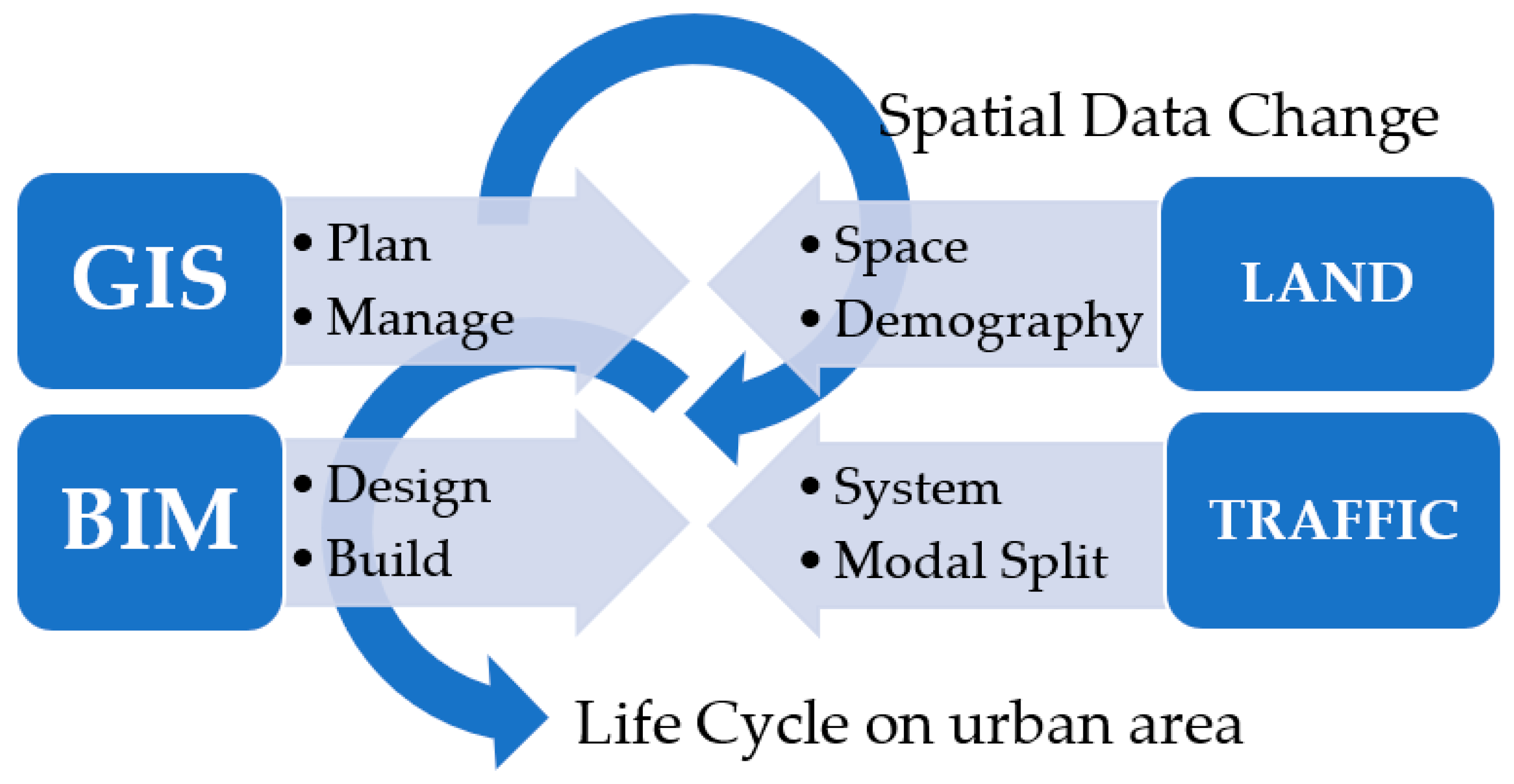
Specific management of spatial data through GISs is traditionally associated with BIM data.
Figure 1 highlights the necessary activities from the land and transport, thus forming a coherent strategic basis for a smart city solution.
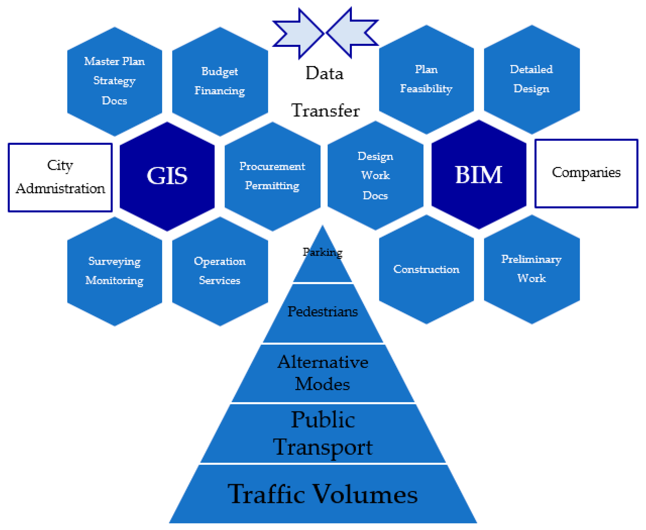
The aim is to serve the area well by the means of transport declared in the transport systems. There is a problem with both land-use and transport data. The integration of traffic data into spatial planning together with 3D design using GISs and BIM can be expressed as shown in
Figure 2.
4. Land-Use and Traffic Data for BIM
Since the beginning of digital design and computer-aided drawing technology, designers have been tackling a fundamental problem: getting enough relevant documents from different databases so that they had a consistent level and could effectively accelerate their own creative activity in designing solutions—that is, the need for integration of BIM and GISs [
21]. The main issue is that even site preparation requires combining design and operational data; however, it always starts with mapping the current state of the site. On the design side, architects and engineers usually have the problem of accessing current information about the designed area in the GIS for accurate context or current conditions. This is where the analytical activities in the different spheres of the civil engineering industry come in to play, by performing extensive surveys. These are all needed to map the current state. What is missing, even if we get enough relevant data and process them, is where to store them in a consistent way so as to be able to use them in a 3D system of the land. Often, planners encounter problems with duplicate information and conflicting data, because file-based workflows are disparate and difficult to use for data exchange [
21]. In the end, everything is collected, merged, and processed in Excel [
15], and all of these data should be incorporated in BIM.
4.1. Land-Use Data for Traffic Planning
This situation is more pronounced for transport-related data in the area of interest. The features of an area based on transport data can be characterised by:
Different traffic flows (traffic volumes);
Different modal splits (e.g., car transport, public transport, alternative modes, pedestrian transport) used to serve the area;
Traffic management in the different transport systems.
Within this we can consider the philosophy of sustainable mobility [
24,
25], which is not commonly perceived at all in land-use data on:
The spatial organisation;
The functional layout that people need to use for their own lives and activities in space;
Their allocation to the transport network.
The above basic structure of traffic and mobility data distribution with the area data creates systemic misunderstandings between urban planners and traffic engineers. The main principle that is missing for the use of BIM in this activity is at the level of linking land-use and traffic planning data. This is one of the reasons why there are very few examples in the world of a robust BIM system being used in the preparation of a site for development.
Transportation-related data are commonly found in transportation planning processes, and are commonly accessible according to the principles of transportation modelling [
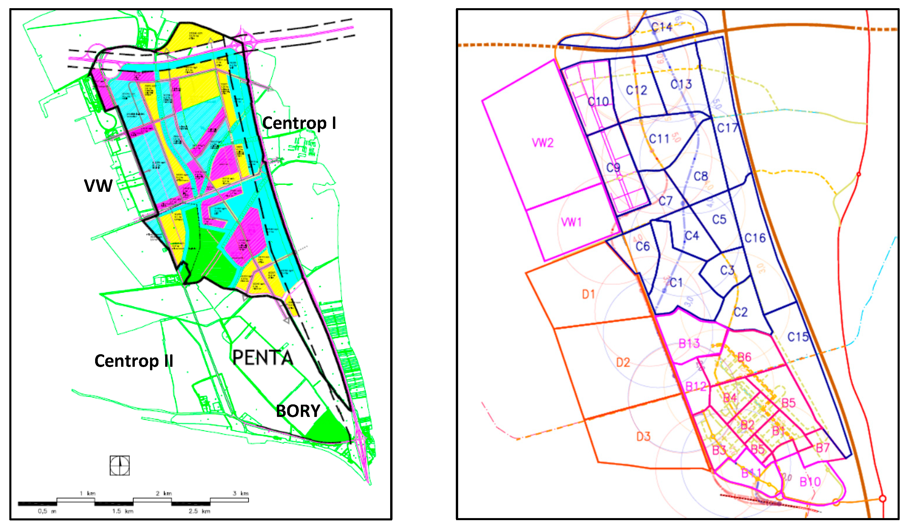
26]. We try to obtain these from the central statistical office or urban GIS. Eventually, traffic engineers together with urban planners find that the area needs to be mapped separately by special traffic–sociological (household) questionnaire surveys. Their outputs are then presented by a matrix of relationships between zones. This is supplemented by the anticipated forecasted activities and the spatial layout of the area to form a transport infrastructure, with an assessment of the capacities of each transport system. An example of such an output is shown in
Figure 3, which presents a proposal for a new land-use plan for the northwestern part of the city of Bratislava, and the creation of a zonal layout to examine the transport infrastructure. Details have been published in [
27], and for the new Bratislava city centre in [
28].
In order to meet the tendencies of the current trend of smart growth, it is necessary to seek to serve the urban area over short distances in different scenarios, precisely to vary the modal split. The corresponding principles for the needs of the city of Bratislava have been analysed in [
29].
The main deficiency is that few cities have the same defined needs in their GIS databases or purpose-built databases. Even when cities do create and update new transportation-zoning policies, they rarely look for continuity from the past, thus failing to achieve systemic solutions. It is also a mistake each time the forecast outlook is re-evaluated “with new trends”, and then the overall system is lost again, even for the planning period. The inappropriate solution is that this strategy must be defined by the state, or at least by the region. In Slovakia, the KOMOD principles used in Austria have been adopted in the last decade. The most recent analysis of this system of work is in [
30], and in the conditions of Bratislava the basic principles have already been determined in [
7]—and especially for the Bratislava railway node in [
31]; however, these did not become part of the Bratislava GIS. Today, at least in state contracts in Slovakia, this methodology is required if transport planning tools are required. Systematically, however, BIM is not applied for 3D design and its management output.
4.2. Traffic Data for 3D Management Tools
However, the greatest dispersion in data quality is for transport. These data come from different sources and at different levels of processing. Although in Slovak conditions there are defined principles [
32] for uniform presentation as well as content, they are hardly ever followed. The problem is precisely that the collection of traffic and mobility data is not continuous—planned in time and space so that the data can be updated and shared on an ongoing basis. Cities and regions do not have a system for collecting traffic and traffic-related data, which are tracked point-by-point in terms of the transportation network, and do not track at all with the space and functions of the land. Despite the existence of the National Transport Information System [
33], there are no declared principles for the input of transport data in a universal and systemic structure, which should not only serve to provide public information, but should also have an interface for relevant management data, and in sufficient detail for design or planning purposes. In this way, a high-quality and consistent level of traffic data would be achieved across the board. However, the real issue is where the detailed traffic data reside:
In the traffic control centres, which most often manage the signal-controlled intersections and their data collection on each leg of the junction;
Detailed road cross-section data from road and highway authorities, where real-time data on traffic volumes and traffic flow composition are also collected;
Traffic data from municipal parking systems from parking garages, parking lots, or on-street parking;
Data from public transport—passengers on public transport lines, turnover at public transport stops and stations, etc.;
From junction data values for pedestrian or bicycle traffic.
A traffic engineering analysis is always used to create a traffic model. This serves first to confirm the present state of the urban area, and then enables testing in different scenarios of the development over time [
9]. The advantage of BIM is that different options can be sought at the beginning of the design activities, even before the actual transport infrastructure is designed. From a land-use point of view, the essence is the sequential assignment of origin–destination relationships of individual investments as well as tangential ones, through citywide traffic flows in relation to the specific area to be designed.
The basic steps of a comprehensive transportation data analysis activity include sub-outputs that can be identified as follows [
34]:
Comprehensive modification of the traffic model of car or public transport, and design of many working versions according to the principles of engineers and urban planners for the creation of urban roads;
Evaluation of the modal split and the transition from car traffic to public transport, possibly with the inclusion of alternative transport;
Carrying out an overview of traffic flows in several variants and scenarios of present and/or new public transport line routing in the study area, based on detailed scenarios of car traffic;
Demonstrating the collapse and saturation of car traffic flows in the street network in the study area, without addressing new public transport routes or the transport infrastructure itself;
Identification of the sections with the highest traffic volumes or the most congested networks, and the prospective networks of urban public, alternative, or car transport in the solved area in the context of sustainable mobility;
Testing new public transport routing or variation of new streets in the territory, creating new supply and demand for passengers and city residents according to the current or future conditions in the trends of New Urbanism [
35].
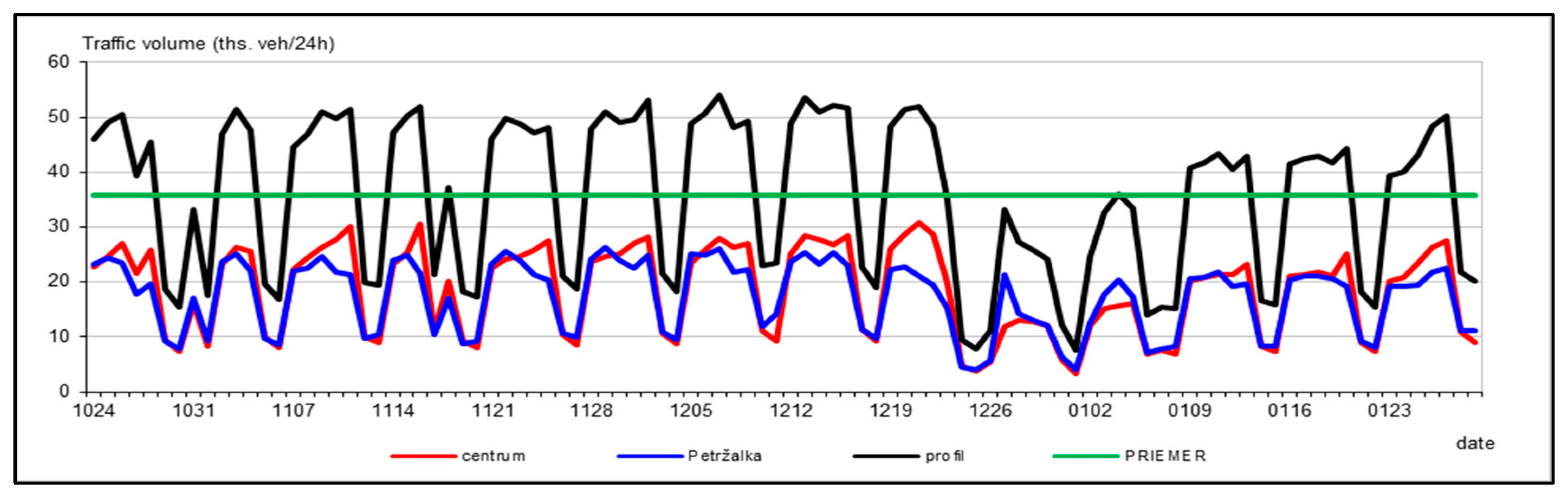
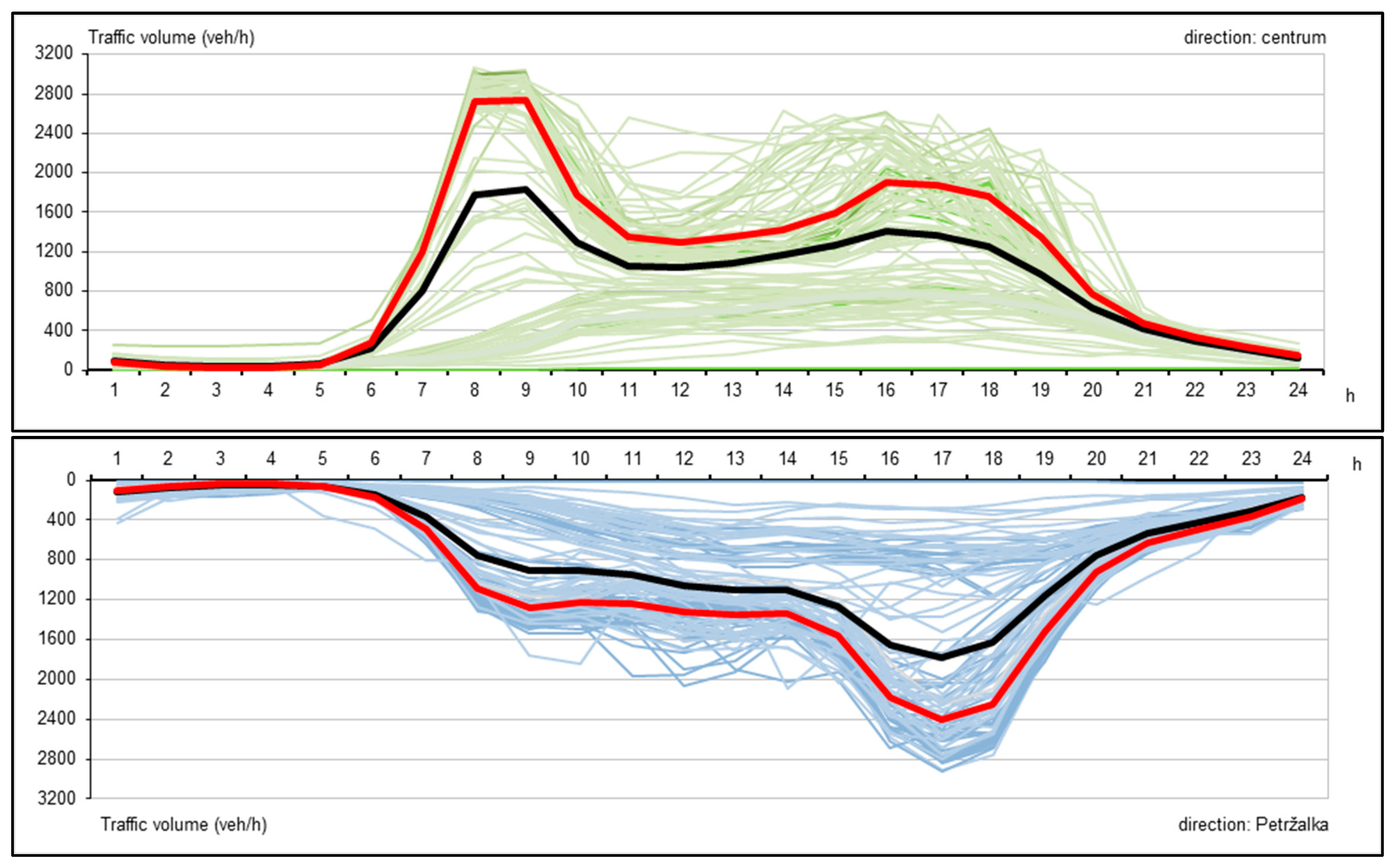
Figure 4 shows an example of long-term traffic data measurement that is analysed in real time of approximately 2–3 months. A normal cross-section of a local roadway from a longitudinal survey is shown in
Figure 5. Behind these graphs are detailed traffic data that could be used for 3D databases in BIM, usually imported from project documentation or from traffic control rooms into the city’s GIS database.
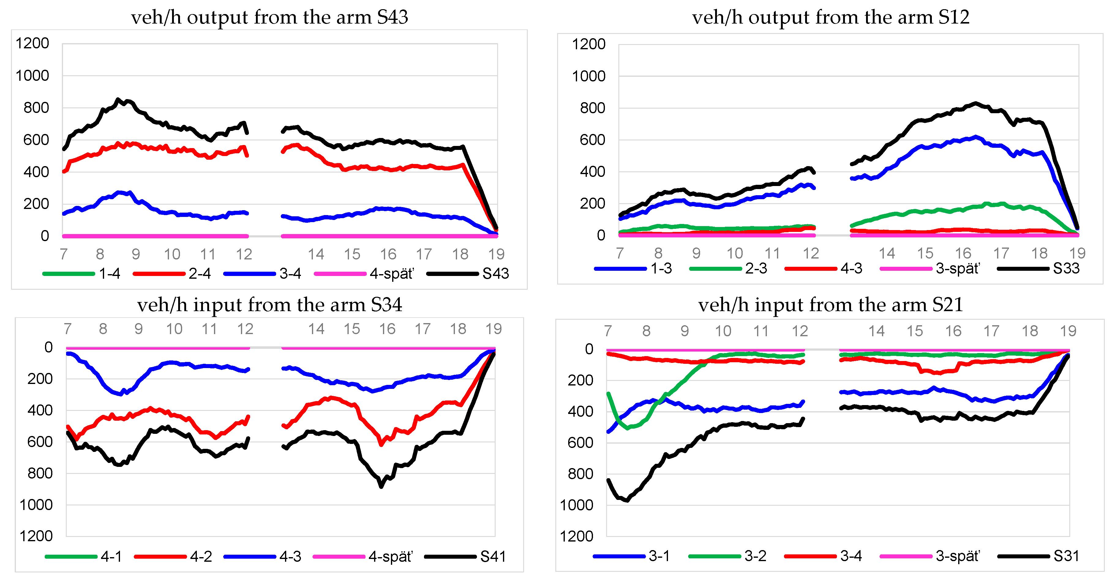
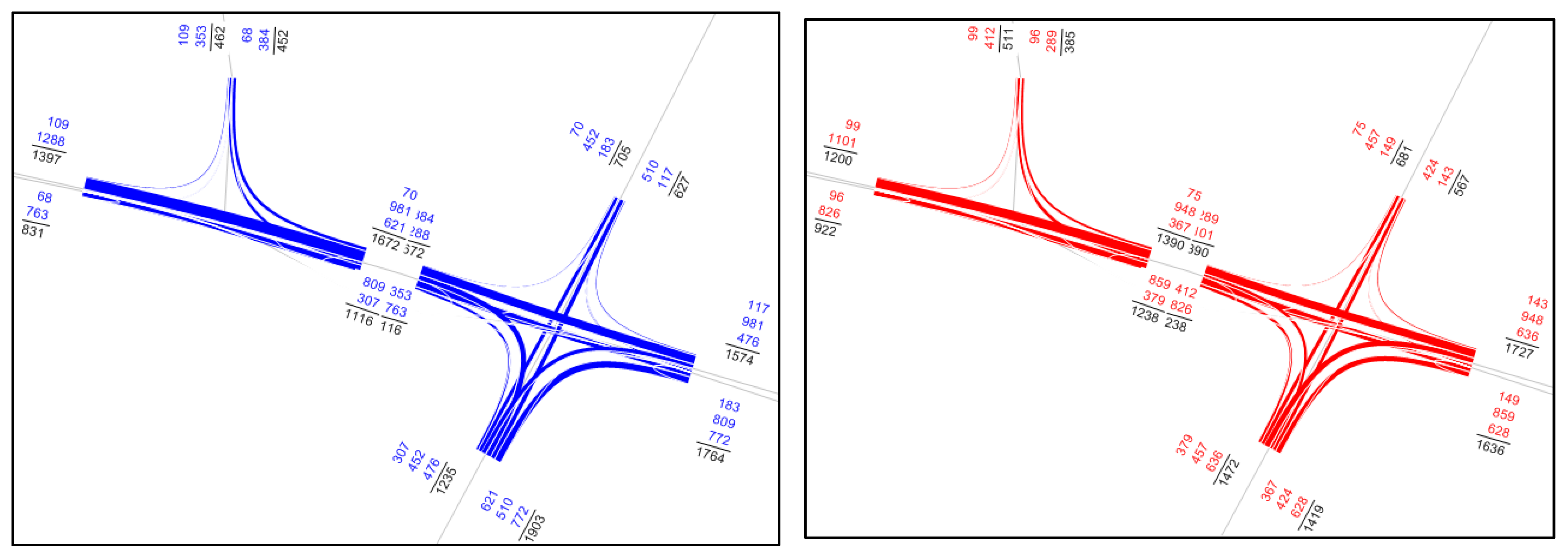
The most complex issue in the area is determining the routing of traffic flows in the area of the planed project. To do this, it is necessary to have detailed intersections mapped from defined area, which is required by the city, whether the junctions are controlled by traffic lights or roundabouts, or are uncontrolled. An example of the output for the database is shown in
Figure 6, where two arms of a junction are divided, with the traffic routing split at both the entrance and exit arms—in a cross-section of the street itself.
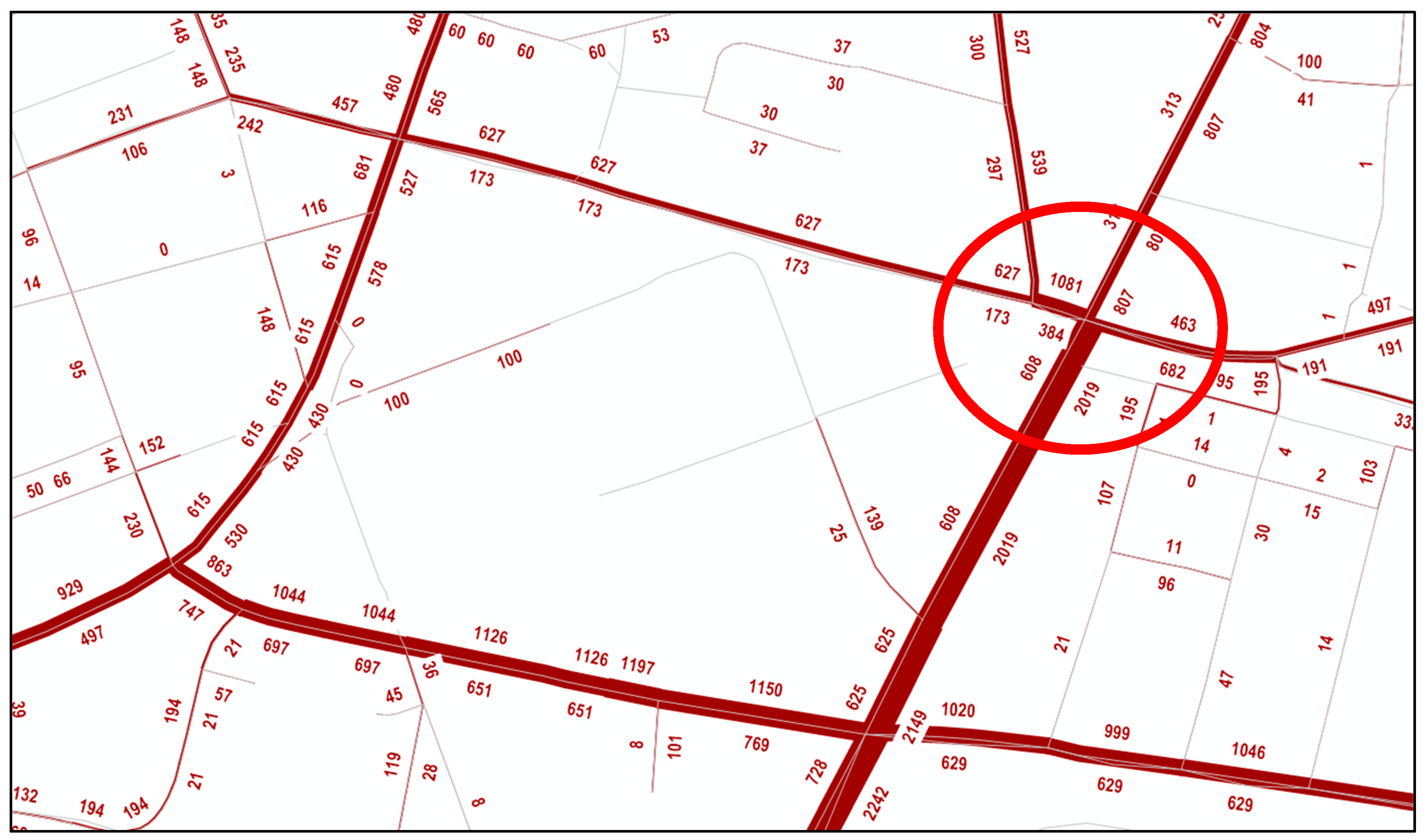
In this way, the traffic engineer or designer has specific junction data with precisely defined traffic flow capacities to size. Spatially, we can imagine that for a simple BIM project, according to [
23], an area with approximately 5–8 intersections and approximately 12–15 streets is addressed. However, the important fact is that just such a traffic data system can be inserted into GIS databases or directly into a complex project solution in BIM. The complexity of this work was analysed in [
36]. The simple output for a junction in the morning (blue colour) and afternoon (red colour) peak hours, as a base traffic dimension for a road engineer or expert for noise calculation or environmental decisions in BIM, is shown in
Figure 7 (the position of the junction is in the red circle in Figure 9 in the traffic model).
5. Traffic Model as Tool of Traffic Planning for BIM
The most probable traffic engineering and planning activity for BIM is anticipated to be in traffic modelling. As an example, a traffic model of the city of Bratislava and its region was developed in the traffic planning software PTV Visum (version 18 and it works in all newer versions) [
37]. The basic attributes of the quality of the development of the area itself, and the resulting quality of the traffic conditions from the newly emerging road infrastructure, can be divided into:
Spatial planning requirements;
Transport and operational conditions;
Traffic and engineering background;
Transport planning tools.
In this sequence, there should also be a technical requirement for individual spatial and traffic databases for BIM.
The design of the zonal structure of the traffic model is based on the definition of the urban area for the traffic model, and consists of internal and external zones. These zones serve as origins and destinations for trips made within a day (or part of a day). The area of the capital city of Bratislava has 263 internal zones in the traffic model, which correspond to the basic settlement units. The outer zones include municipalities in the agglomeration of the capital city and other aggregated municipalities of more distant areas, totalling 347 zones.
Figure 8 shows the model area of the traffic model of a part of the new city centre of Bratislava according to [
7], which was modified and changed according to the principles of [
28] for the newly designed city centre. This represents the allocation to the transport network.
Figure 9 shows the output of the traffic model in its current state.
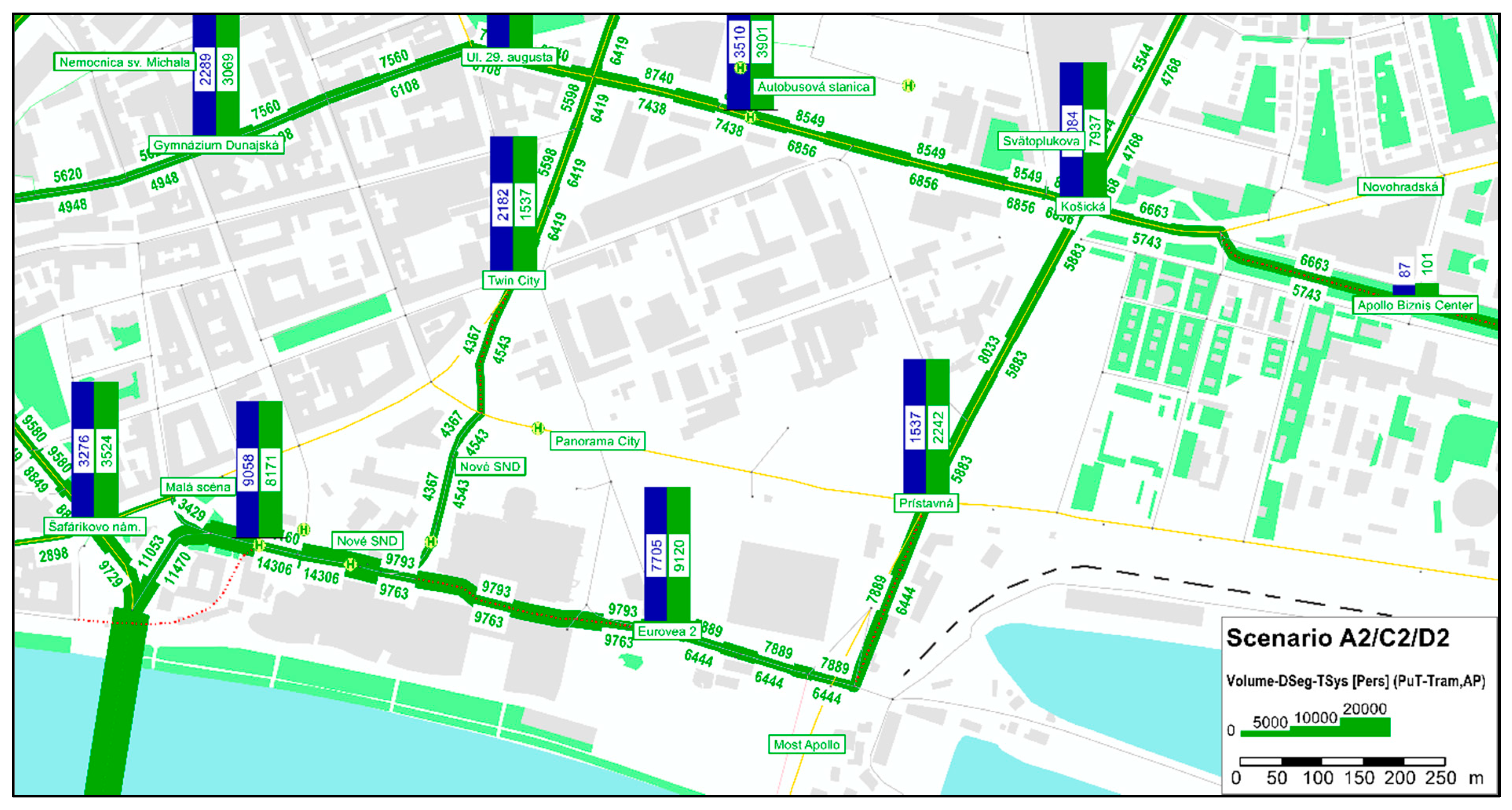
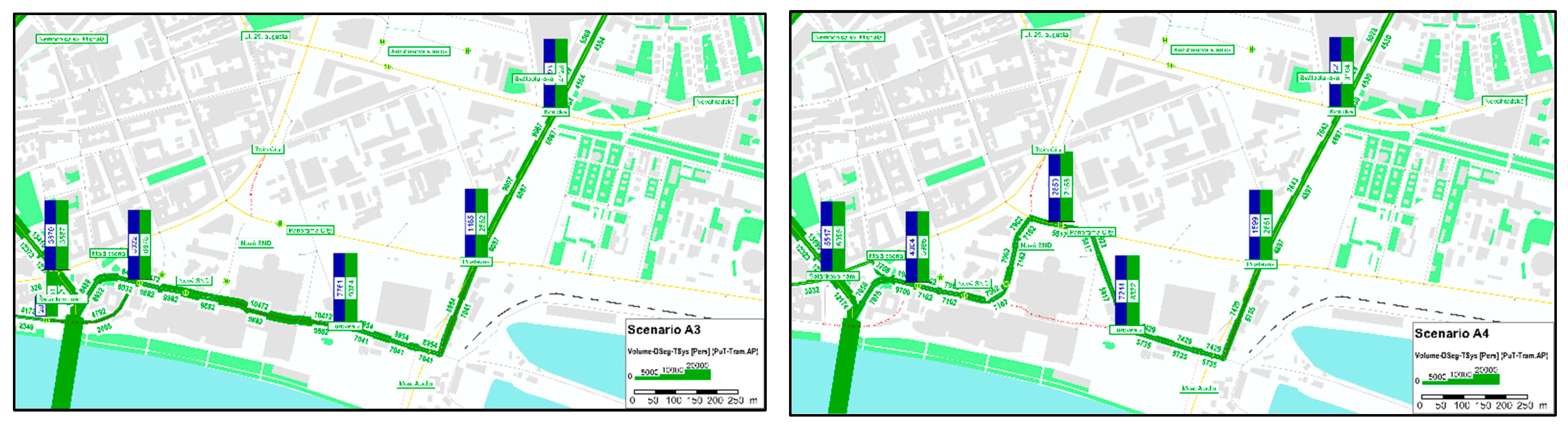
The design scenarios for a comprehensive network of tram lines around the entirety of the new city centre are very important. In the context of the relocation of the modal split for sustainable mobility, not only transport principles, but also spatial principles, were addressed in the matrix databases. In terms of capacity, the transport databases looked for contexts of preference for public transport over car transport. In terms of the area of the city centre, this was primarily about the spatial arrangement of functions and their inputs and outputs in the transport network. Here, the entrances and exits to the public garages were optimised, as along with the optimisation of the locations of public transport stops. The basic options of many scenarios from different investors’ boundary conditions in the area addressed the transport outputs. An important conclusion was noted, clearly demonstrating the necessity of dealing comprehensively with both land use and transport systems at the same time; this is already the answer to databases for BIM. An example of the resulting public transport solution for trams around the new centre is shown in
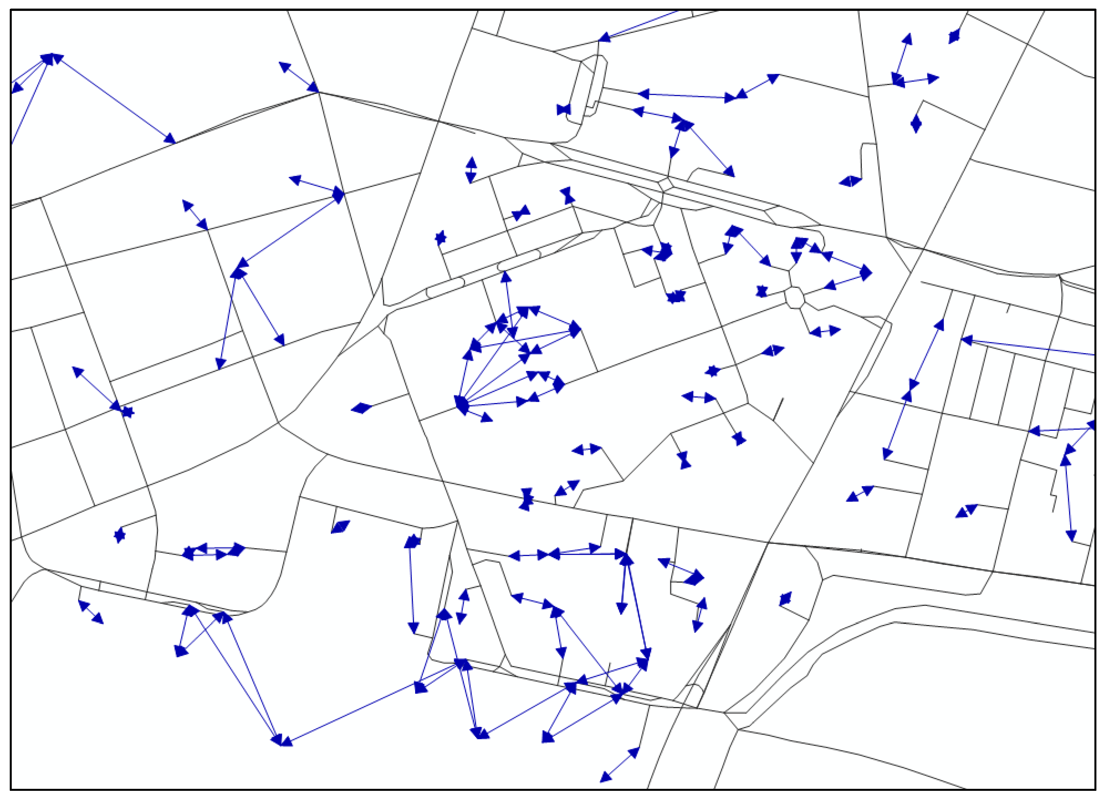
Figure 10. This was preceded by various details of the tram route alignment (
Figure 11), which were linked to passenger values and the turnover of alighting and boarding passengers at the stops. These were optimised by availability in the area. The complex agenda of the traffic planning and traffic engineering works is presented in [
38].
Expert activities in traffic modelling of both public and car traffic in the assessment of the land-use service, as well as for technical solutions in the design of the new city centre of Bratislava, have clearly demonstrated the need to deal comprehensively with the digital management of engineering activities. The result is dozens of detailed model scenarios that “play” with additional details of the tram lines—whether the exact positions and shifting of stops due to existing crossings, or the insertion new pedestrian and cycling routes. Separate issues that aid in modelling are the creation of detailed isochrones maps of public transport stops, or the accessibility of individual objects within the framework of sustainable mobility and smart cities. Having everything in one system would certainly make the whole operation more efficient. The engineering and urban planning work around the new city centre has been carried out for more than 16 years.
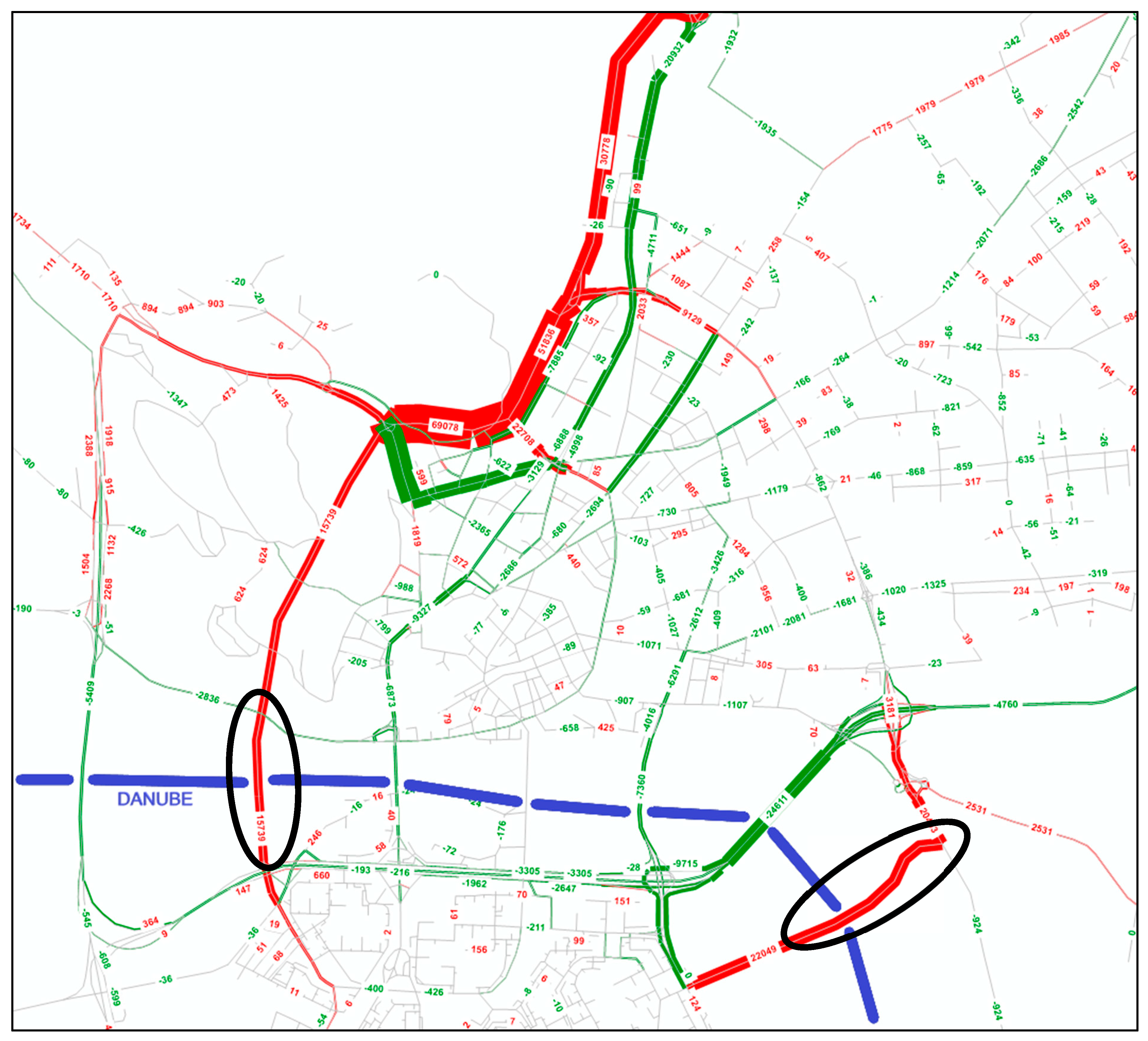
Servicing the area of the new city centre itself with the interconnection of other city boroughs in a complex environment would demonstrate the suitability of the engineering constructions and structures. As a final example, we can point to the search for the optimal locations of two new urban bridges with tramway infrastructure [
39] across the river Danube. Interesting, however, is the disproportional scenario as a final decision output shown in
Figure 12, which highlights the increase in vehicle traffic on the new city bridges (blue colour), and from where there is a reduction in the values of the traffic volumes in the city network (red colour). It should be noted that in the traffic model, in addition to the bridges, there is also the second city ring road in the north of the city, which Bratislava still does not have, although it has been in the master land-use plan [
6] since 1985. If the city had a 3D (or even 4- or 5D) system of planning and land-use management with traffic and construction activities, this would surely provide enormous economic benefits for the capital of Slovakia.
6. Conclusions
The results presented in this article are of great importance for practical experiences. The challenge of addressing this issue is wide open, as BIM has so far been a very strictly followed digital management system for providing detail within the construction of structures. Slowly, BIM is also transforming to deal with the issue of linear transportation structures, where there are dozens of examples, but not thousands of solutions as there are with the architecture of classical buildings. The issues of spatial planning and traffic engineering in the output of the traffic model with its scenarios can also help spatial planners and urban planners, as well as road engineers. The outputs of the model based on and intertwined with the data of the land use are the basis for the design and dimensioning of the transportation infrastructure. This is also why this activity is still far from examining the details on a scientific basis; it is primarily an engineering activity that can add value and help in the management of processes from the preparation of the land, environment, and traffic service to the sub-detail of the building object.
It can be concluded that the public sector is slowly moving forward in the field of traffic engineering and urban planning activities, as well as in the use of transport planning tools. Thus far, there is a varied set of requirements, and it should be noted that data management is very often left “free” to the investors—mainly private ones. On the other hand, for public investments, too much detail is defined that does not have an impact on the systemic solution of what to do with the data and information that are the output of the project documentation; the result is an imbalance of engineering activities, which are nevertheless very demanding in the preparation, implementation, and actual processing of the digital documentation. Parts of the analytics and management of land use and the traffic engineering activities are not defined, so even public investors are not able to assess whether the result is adequate and sufficiently accurate when taking over the subject of the contract. This is a fundamental mistake, because in Slovakia we already have a number of implemented projects under the BIM umbrella, but these concern only the objects and structures themselves; the spatial overview of the land use is somehow omitted.
The aim of this article was to start a discussion about the conditions of Slovakia for the common use of traffic engineering and urban planning. The main issue is the need for the preparation and rehabilitation of local urban roads and public spaces in cities in a complex 3D design. Such a range of activities over time needs to be addressed comprehensively—especially in cities. Our cities do not have enough experts for this field of activity; however, the principles and rules must be declared by the state. We can confirm this with certainty according to the real situation in our cities, because even the basic GIS databases, if they exist in our cities, are diverse, posing great problems for planners in the use of BIM.
The experiences that are presented in this paper are based on more than 165 projects and studies, which have the same content and system of simple databases of traffic- and transport-related data in land use. This represents the experience of 20 years of working with investors and city authorities across the country. It can be concluded that planners and investors alike would prefer to have a comprehensible and measurable system, and are willing to agree to a “value added”, whereby our cities could start to create at least some space for the systematisation of 3D management and design, thus also fulfilling the requirements of “sustainable mobility” and “smart cities”.


 ,
, 