
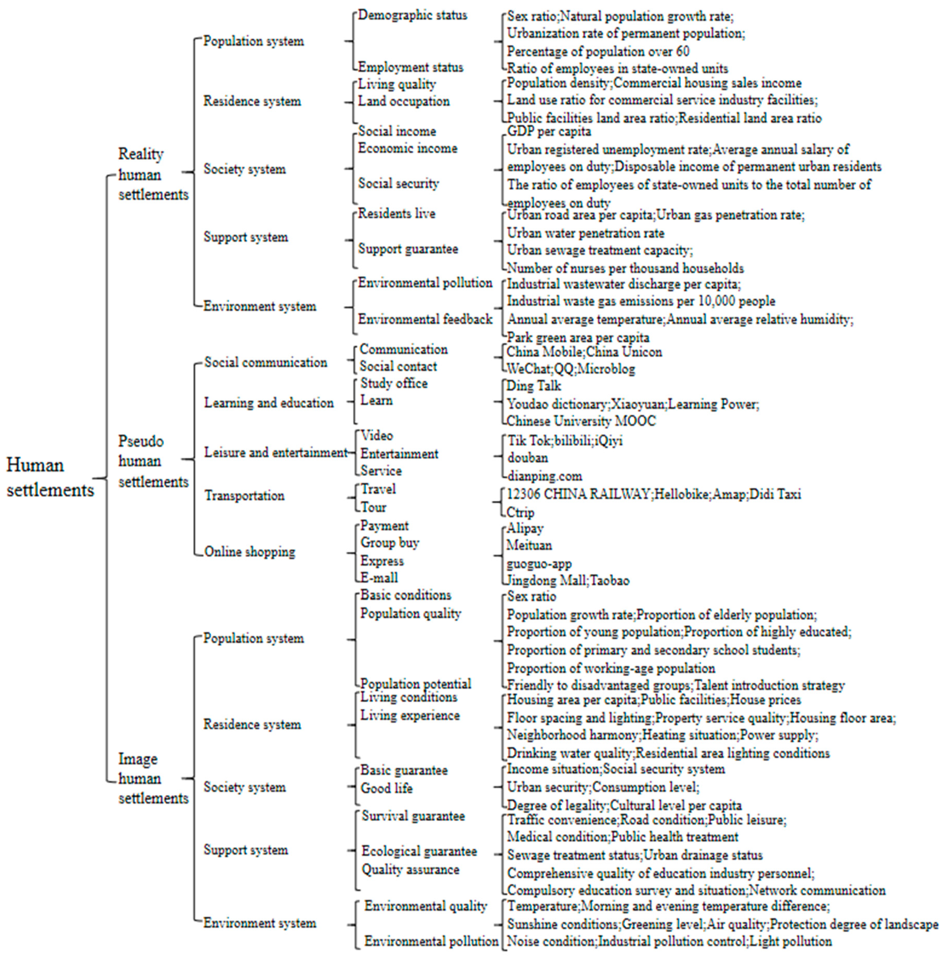
Urban “Three States” Human Settlements High-Quality Coordinated Development

Abstract
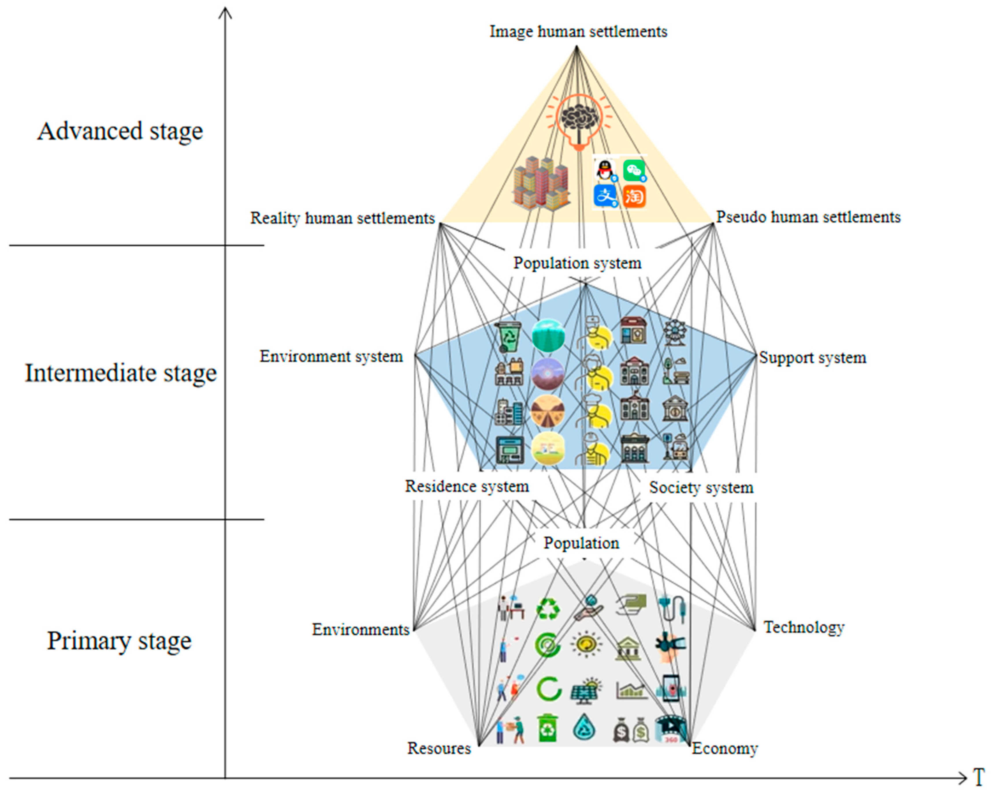
:1. Introduction
2. Materials and Methods
2.1. Data Source
2.2. Research Method
- (1)
- Original matrix: is the index value of the b-th index of the a-th city.
- (2)
- Calculate the weight of the a-th city of the b-th index: .
- (3)
- The entropy value of the index: .
- (4)
- Difference coefficient: .
- (5)
- Calculate the weight of the b-th index: .
- (6)
- Calculate the result of human settlements: .
3. Results
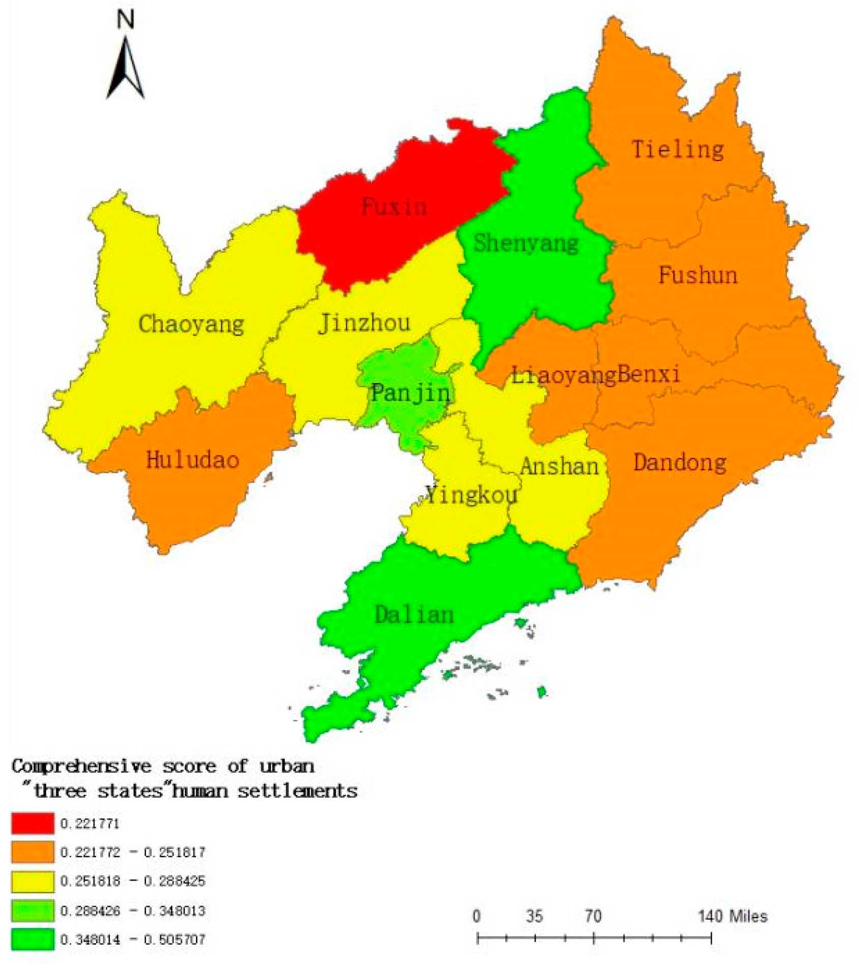
3.1. Spatial Pattern of High-Quality Development of “Three states” Human Settlements
3.1.1. Overall Characteristics of the Spatial Pattern
- (1)
- Spatial structure characteristics of regional differentiation
- (2)
- “Hump” spatial-structure characteristics
- (3)
- “Dual-core” spatial-differentiation characteristics
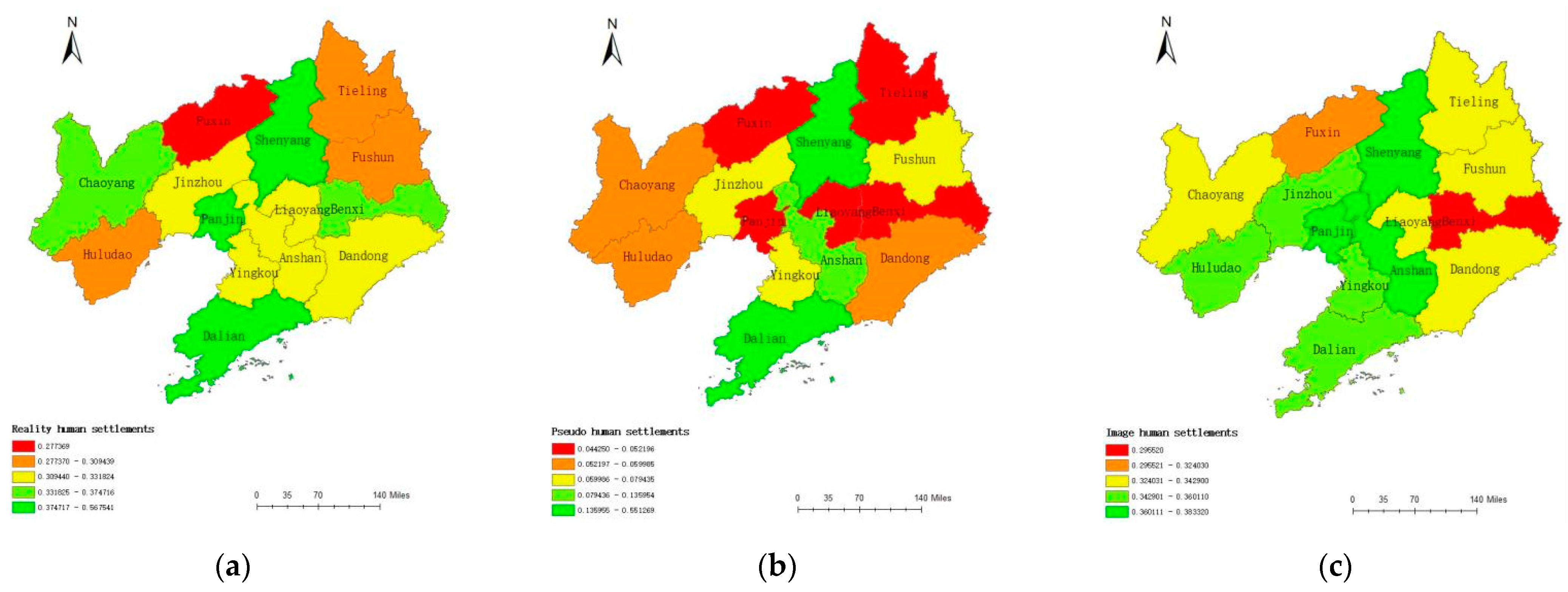
3.1.2. Morphological Characteristics
- 1.
- Reality human settlements
- 2.
- Pseudo-human settlements
- 3.
- Image human settlements
- 4.
- “Three states” human settlements
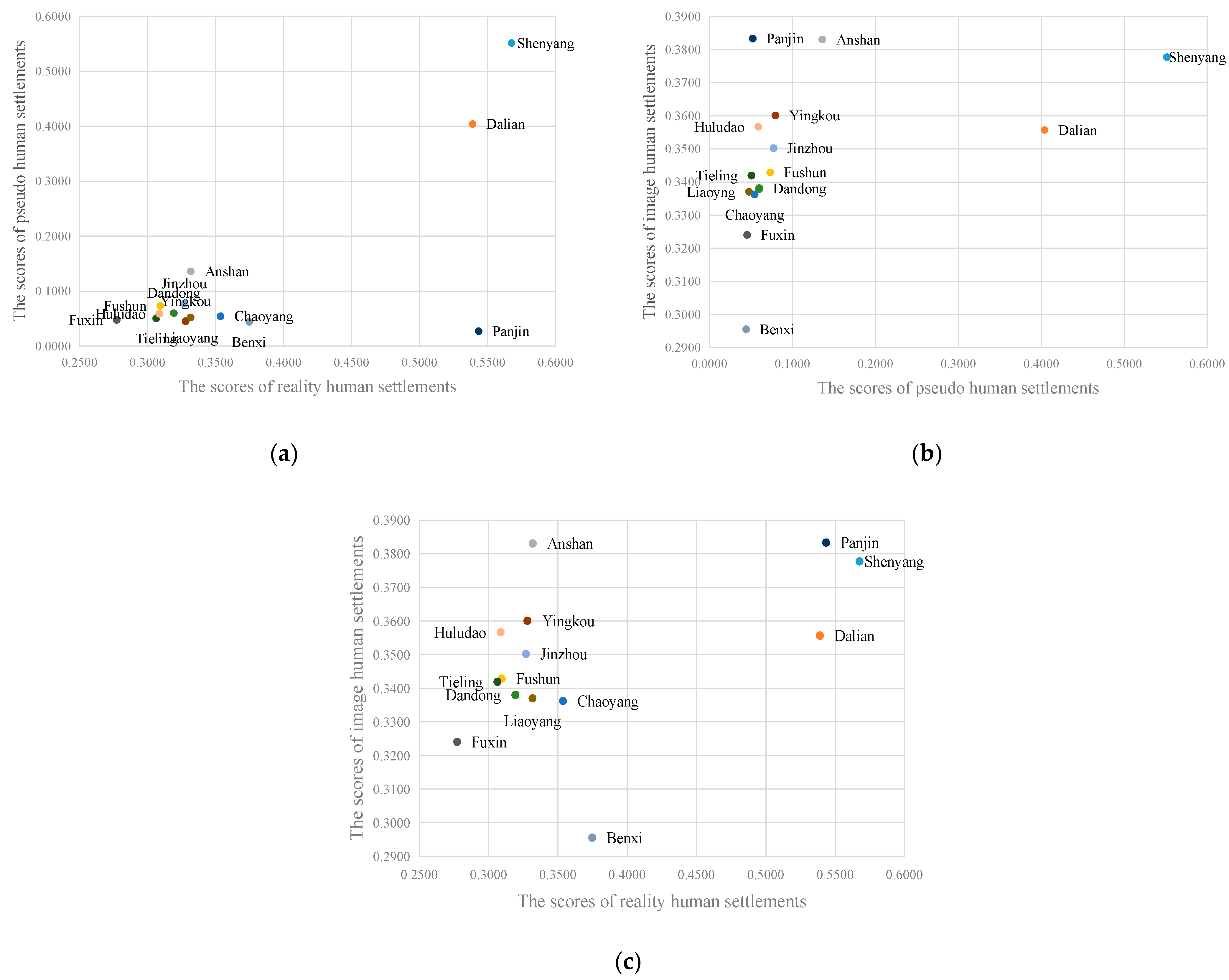
- (1)
- From the perspective of the two-dimensional spatial equilibrium between RHSs and PHSs, the scores of RHSs in Shenyang and Dalian are 0.5675 and 0.5389, respectively, while the scores of PHSs are 0.5512 and 0.4039, respectively, which are in the double high level spatial equilibrium. Panjin’s RHSs score is 0.5433, which is higher than that of PHSs (0.0271), which shows that the development quality level of PHSs is lower than the single high level of RHSs. The development of RHSs and PHSs in other cities in Liaoning Province is relatively lagging. Among them, Fuxin’s RHSs score is 0.2773, and its PHSs score is 0.0476, both of which are relatively backward, and their development lags more prominently.
- (2)
- From the perspective of the two-dimensional spatial equilibrium between PHSs and IHSs, Liaoning Province generally presents a situation of coexisting equilibrium and disequilibrium. The scores of PHSs in Dalian and Shenyang are 0.4039 and 0.5512, and the scores of IHSs are 0.3557 and 0.3777, respectively. The development of PHSs and IHSs in the two cities is more coordinated; Panjin’s PHS score is as high as 0.3833, which is higher than most areas; Panjin’s PHS score is only 0.0522, which is lower than most areas; and the development of PHSs and IHSs in Panjin presents a disequilibrium state. Dandong, Jinzhou, Yingkou and other cities also show a trend of development of IHSs than of PHSs.
- (3)
- From the perspective of the two-dimensional spatial equilibrium between RHSs and IHSs, the scores of RHSs in Shenyang, Dalian and Panjin were 0.5675, 0.5389 and 0.5433, respectively, and the scores of IHSs in Shenyang, Dalian and Panjin were 0.3777, 0.3557 and 0.3833, respectively. All of them are at a relatively high level, belonging to a reality-image high-level spatial equilibrium state; Chaoyang’s RHSs score is 0.3536, and it IHSs score is 0.3362. The quality of reality-image human settlements is doubly low, belonging to the low-level spatial equilibrium state between the development of RHSs and the development of IHSs. Urban areas such as Dandong, Yingkou and Huludao belong to the state of high IHS and low RHS development quality.
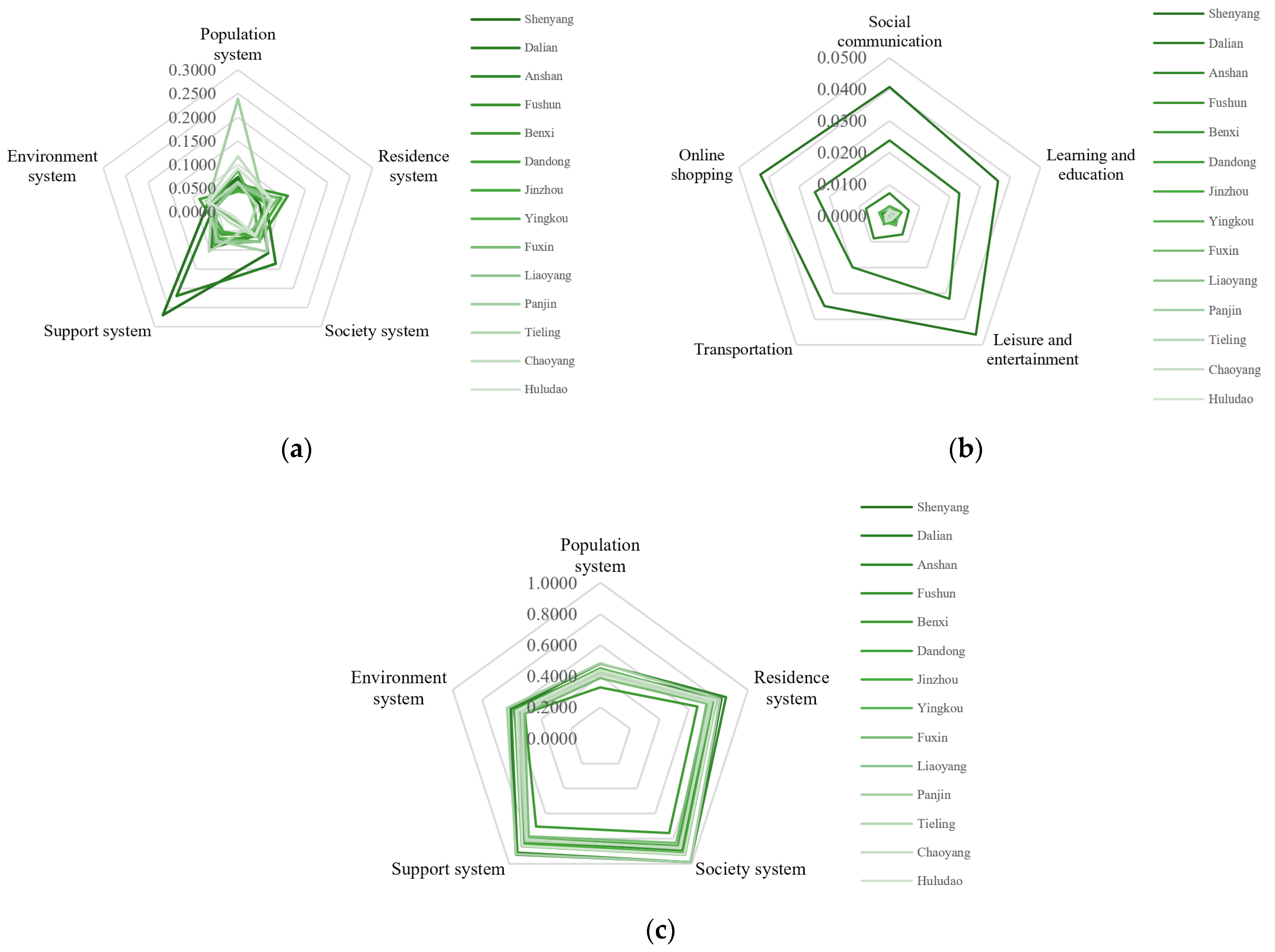
3.1.3. Subsystem Characteristics
- 1.
- Reality human settlements
- 2.
- Pseudo human settlements
- 3.
- Image human settlements
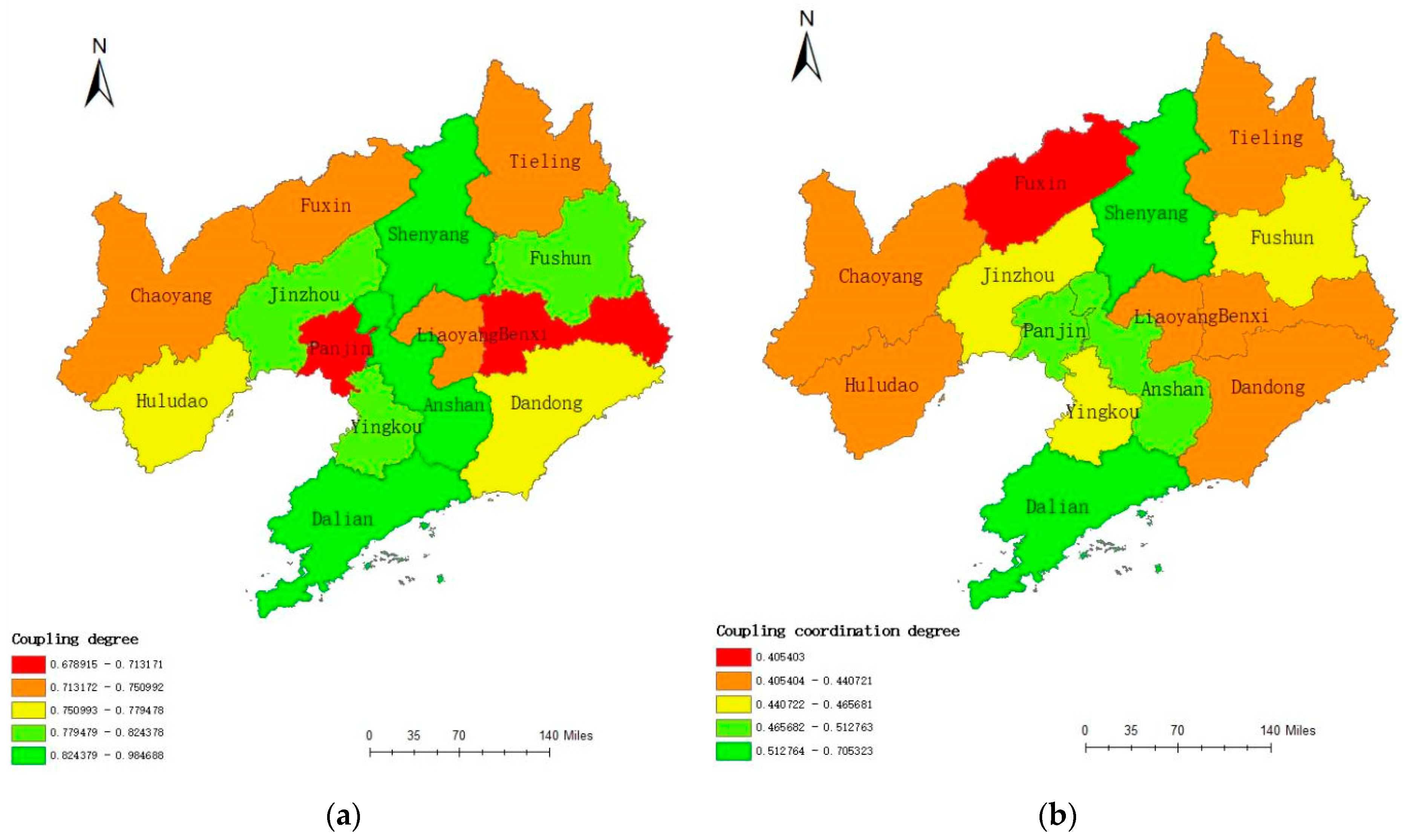
3.2. “Three States” Human Settlements High-Quality Development Coupling-Coordinating Spatial Relations
3.2.1. Corresponding Type
3.2.2. Coupling Coordination Characteristics
3.3. Driving Mechanism and Optimized Path of High-Quality Coordinated Development of “Three States” Human Settlements
3.3.1. Driving Mechanism
- 1.
- Factor analysis
- 2.
- System analysis
3.3.2. Optimized Path
- 1.
- Shenyang and Dalian “dual cores” lead “three states” human settlements to develop in high-quality
- 2.
- The “three states” of reality, pseudo and image have an equal emphasis on high-quality coordination of human settlements
- 3.
- Attach importance to the high-quality development of the subject “people” in “three states” human settlements
4. Discussion
5. Conclusions
- Spatial pattern of high-quality development of “three states” human settlements. (1) The 14 prefecture-level cities in Liaoning Province show obvious regionally differentiated spatial-structure characteristics, forming a “hump” spatial structure centered on southern Liaoning, northern Liaoning and central Liaoning and forming “dual-core” spatial differentiation characteristics, with Shenyang and Dalian as the pillars. (2) According to the morphological characteristics of high-quality development of human settlements, RHSs in Liaoning Province can be divided into core area, transition zone and starting zone; PHSs can be divided into the high-speed development area composed of Shenyang and Dalian and the slow-speed development area composed of other cities. The dual-core spatial distribution characteristics are remarkable. In IHSs, Shenyang and Dalian score lower and failed to lead the high-quality coordinated development of IHSs. Whether it is two-dimensional development of reality-pseudo, pseudo-image or reality-image human settlements, Liaoning Province as a whole is in a state of coexisting equilibrium and disequilibrium. (3) Among the subsystems of RHSs, Shenyang and Dalian score much higher than other cities in terms of support systems and social systems. In PHSs, Shenyang and Dalian rank in the forefront of scores in all dimensions, and the overall development level of PHSs is relatively high. It is not Shenyang and Dalian that score higher in terms of systems of IHSs but Panjin, which scores higher in both social systems support systems.
- The coupling coordination spatial relationship of high-quality development of “three states” human settlements. (1) RHSs, PHSs and IHSs do not completely present a coordinated corresponding relationship, forming the “high–high–high” and “low–low–low” types represented by Shenyang and Fuxin, respectively. The high-level development of RHSs is a necessary condition for the high-quality and high-level development of urban “three states” human settlements. (2) There is a certain correlation between the high-quality development coupling degree and coupling coordination degree of “three states” human settlements. The high-value areas of the two correspond to one another, showing a “dual-core” spatial distribution dominated by Dalian and Shenyang. Low-value areas include cities such as Benxi and Liaoyang. From a spatial perspective, the types of coupling coordination are basic coupling and basic coordination.
- The driving mechanism and optimized path of the high-quality coordinated development of “three states” human settlements. (1) Through the calculation of the geographic detector, it is possible to quantitatively analyze the degree of influence of different individual index factors on the comprehensive index layer. The core driving factors of RHSs are population status, living quality, etc., and the population system is the main driving system. The core driving factors of PHSs are social interaction, learning, etc., and social communication is the main driving system. The population quality and basic conditions in IHSs are the core driving factors, and the support system is the core driving system, among which medical conditions dominate. (2) By exploring the spatial pattern of the high-quality coordinated development of “three states” human settlements in Liaoning Province, this paper proposes the following optimized paths: a. taking Shenyang and Dalian as the “dual cores” to guide the high-quality development of “three states” human settlements; b. Equal emphasis on the high-quality coordination of reality, pseudo and image “three states” human settlements; c. emphasis on the high-quality development of the subject “human” in “three states” human settlements.
Author Contributions
Funding
Institutional Review Board Statement
Informed Consent Statement
Data Availability Statement
Conflicts of Interest
References
- Wu, L. Introduction to Sciences of Human Settlements; China Architecture & Building Press: Beijing, China, 2001; pp. 97–112. [Google Scholar]
- Tian, S.; Li, X.; Yang, J.; Zhang, W.; Guo, J. Spatio-temporal coupling coordination and driving mechanism of urban pseudo and reality human settlements in the three provinces of Northeast China. Acta Geogr. Sin. 2021, 76, 781–798. [Google Scholar]
- Li, L.; Zhang, G. The city development quality of Beijing-Tianjin-Hebei urban agglomeration. Econ. Geogr. 2015, 35, 61–64, 68. [Google Scholar]
- Xu, L.T.; Yao, S.M.; Chen, S.; Xu, Y. Evaluation of eco-city under the concept of high-quality development: A case study of the Yangtze River delta urban agglomeration. Sci. Geogr. Sin. 2019, 39, 1228–1237. [Google Scholar]
- Fang, C. Spatial organization pattern and high-quality development of urban agglomeration in the Yellow River basin. Econ. Geogr. 2020, 40, 1–8. [Google Scholar]
- Tian, L.; Chen, L.; Luo, J.; Sun, K.; Zhou, L.; Wang, Z.; Chen, G. Spatial-temporal evolution and driving mechanism of high-quality development level of non-state-owned economy in China. Econ. Geogr. 2021, 41, 131–139. [Google Scholar]
- Zhu, H.; Zhang, Y.; Lin, M.; Liu, M.; Wang, L.; Wang, L.; Long, F.; Zhang, S.; Yu, W.; Liu, J. High-quality development of tourism industry under the background of land and space optimization: Characteristics, Understanding and key issues. Econ. Geog. 2021, 41, 1–15. [Google Scholar]
- Liu, Y.; Feng, W.; Li, Y. Modern agricultural geographical engineering and agricultural high-quality development: Case study of loess hilly and gully region. Acta Geogr. Sin. 2020, 75, 2029–2046. [Google Scholar]
- Du, P.; Han, Z.; Wang, L.; Yu, X.; Xiao, T. Spatial pattern evolution of economic growth in counties and districts of Northeastern China. Geogr. Res. 2015, 34, 2309–2319. [Google Scholar]
- Zhao, R.; Shen, Y. An analysis of high-quality development of service industry in the Yellow River basin. Econ. Geogr. 2020, 40, 21–29. [Google Scholar]
- Wang, W.; Wang, C. Evaluation and spatial differentiation of high-quality development in Northeast China. Sci. Geogr. Sin. 2020, 40, 1795–1802. [Google Scholar]
- Bai, J.; Liu, R.; Liu, Q. The connotation definition and state evaluation of regional high quality development based on perspective of spatial equilibrium: A case of Shaanxi province. Hum. Geogr. 2020, 35, 123–130, 160. [Google Scholar]
- Hua, X.; Jin, X.; Lv, H.; Ye, Y.; Shao, H. Spatial-temporal pattern evolution and influencing factors of high quality development coupling coordination: Case on counties of Zhejiang Province. Sci. Geogr. Sin. 2021, 41, 223–231. [Google Scholar]
- Zhang, C.; Zhong, C.; Jiang, T.; Li, X. Spatio-Temporal differentiation of regional coordinated development and its influencing factors in china. Econ. Geogr. 2020, 40, 15–26. [Google Scholar]
- Li, X.; Wen, Y.; Li, Y.; Yang, H. High-quality development of the Yellow River Basin from a perspective of economic geography: Man-land and spatial coordination. Econ. Geogr. 2020, 40, 1–10. [Google Scholar]
- Di, Q.; Yu, Z.; Xu, L. Spatial-temporal coordination mode of marine economic development under the background of high quality growth: Based on the empirical study of prefecture-level cities in Circum-Bohai sea. Sci. Geogr. Sin. 2019, 39, 1621–1630. [Google Scholar]
- Wen, X.; Wang, C.; Xiong, Y.; Xiao, J.; Xie, W. Coupling coordination development between new urbanization and financial support in hunan province. Econ. Geogr. 2019, 39, 96–105. [Google Scholar]
- Thomas, F. Marginal islands and sustainability: 2000 years of human settlement in eastern Micronesia. Econ. Ecohist. 2015, 14, 64–74. [Google Scholar]
- Zakerhaghighi, K.; Khanian, M.; Gheitarani, N. Subjective quality of life;assessment of residents of informal settlements in Iran (A Case Study of Hesar Imam Khomeini, Hamedan). Appl. Res. Qual. Life 2015, 10, 419–434. [Google Scholar] [CrossRef]
- Guan, Z.; Elleason, M.; Goodale, E.; Mammides, C. Global patterns and potential drivers of human settlements within protected areas. Environ. Res. Lett. 2021, 16, 064085. [Google Scholar] [CrossRef]
- Morgan, F.S. Geoarchaeological investigations at the Ryan-Harley Paleoindian site, Florida (8JE1004): Implications for human settlement of the Wacissa River Basin during the Younger Dryas. Geoarchaeology 2020, 35, 451–466. [Google Scholar]
- Kemperman, A.; Timmermans, H. Green spaces in the direct living environment and social contacts of the aging population. Landsc. Urban Plan. 2014, 129, 44–54. [Google Scholar] [CrossRef]
- Baiocchi, G.; Creutzig, F.; Minx, J.; Pichler, P. A spatial typology of human settlements and their CO2 emissions in England. Glob. Environ. Chang. 2015, 34, 13–21. [Google Scholar] [CrossRef]
- Zhao, Z.; Sharifi, A.; Dong, X.; Shen, L.; He, B. Spatial Variability and Temporal Heterogeneity of Surface Urban Heat Island Patterns and the Suitability of Local Climate Zones for Land Surface Temperature Characterization. Remote Sens. 2021, 13, 4338. [Google Scholar] [CrossRef]
- He, B.; Zhao, D.; Xiong, K.; Qi, J.; Ulpiani, G.; Pignatta, G.; Prasad, D.; Jones, P. A framework for addressing urban heat challenges and associated adaptive behavior by the public and the issue of willingness to pay for heat resilient infrastructure in Chongqing, China. Sustain. Cities Soc. 2021, 75, 103361. [Google Scholar] [CrossRef]
- Blankholm, H.P. In the wake of the wake. An investigation of the impact of the Storegga tsunami on the human settlement of inner Varangerfjord, northern Norway. Quat. Int. 2020, 549, 65–73. [Google Scholar] [CrossRef]
- Shelby, A.; James, J.; Adam, F. Human settlement and Mid-Late Holocene coastal environmental change at Cape Krusenstern, Northwest Alaska. Quat. Int. 2020, 549, 84–97. [Google Scholar]
- Seth, Q.; Jeffrey, T.C.; Stephanie, S.D.; Donald, P.S. Landscape evolution and human Settlement Patterns on Ofu Island, Manu’a Group, American Samoa. Asian Perspect. 2016, 54, 208–237. [Google Scholar]
- Ferdyn-Grygierek, J.; Sarna, I.; Grygierek, K. Effects of Climate Change on Thermal Comfort and Energy Demand in a Single-Family House in Poland. Buildings 2021, 11, 595. [Google Scholar] [CrossRef]
- Babuna, P.; Han, C.; Li, M.; Gyilbag, A.; Bian, D.; Awudi, D.A.; Supe, T.R.; Yang, S.; Yang, X. The effect of human settlement temperature and humidity on the growth rules of infected and recovered cases of COVID-19. Environ. Res. 2021, 197, 111106–111114. [Google Scholar] [CrossRef]
- Anastasia, G.; Igor, S. Human settlement, landscapes and environmental change in the Russian Altai Mountains during the Holocene. Quat. Int. 2018, 470, 176–193. [Google Scholar]
- Serrao-Neumann, S.; Crick, F.; Harman, B.; Sahin, O. Improving cross-sectoral climate change adaptation for coastal settlements: Insights from South East Queensland, Australia. Reg. Environ. Chang. 2014, 14, 489–500. [Google Scholar] [CrossRef] [Green Version]
- Bradlow, B.; Bolnick, J.; Shearing, C. Housing, institutions, money: The failures and promise of human settlements policy and practice in South Africa. Environ. Urban. 2011, 23, 267–275. [Google Scholar] [CrossRef]
- Piotr, G.; Anna, M.; Mateusz, S.; Sylwester, C.; Katarzyna, T.; Agnieszka, W. Temporal variation of prehistoric human settlement recorded in the oxbow lake deposits of San river (Sandomierz Basin, SE Poland). Geochronometria 2020, 46, 148–160. [Google Scholar]
- Tang, L.; Ruth, M.; He, Q.; Mirzaee, S. Comprehensive evaluation of trends in human settlements quality changes and spatial differentiation characteristics of 35 Chinese major cities. Habitat Int. 2017, 70, 81–90. [Google Scholar] [CrossRef]
- Baccini, P. The Horizontal Metropolis between Urbanismand Urbanization; Springer: Berlin/Heidelberg, Germany, 2018; pp. 111–118. [Google Scholar]
- Dimelli, P. The effects of tourism in Greek insular settlements and the role of spatial planning. Knowl. Econ. 2017, 8, 319–336. [Google Scholar] [CrossRef]
- Li, X.; Guo, Y.; Tian, S.; Bai, Z.; Liu, H. The spatio-temporal pattern evolution and driving force of the coupling coordination degree of urban human settlements system in Liaoning province. Sci. Geogr. Sin. 2019, 39, 1208–1218. [Google Scholar]
- Yang, X.; Sun, J.; Lun, L.; Wang, Q. Spatial characteristics and social effects of residential spaces in the tourist destination Qiandaohu. Acta Geogr. Sin. 2018, 73, 276–294. [Google Scholar]
- Li, B.; Zeng, C.; Liu, P.; Dou, Y. System characteristics and dynamic mechanism of transformation development of human settlement environment in traditional villages: A case study of lanxi village Jiangyong county. Econ. Geogr. 2019, 39, 153–159. [Google Scholar]
- Chen, J.; Hong, W. The comparative study of human settlement changes in eastern Guangdong and southern Fujian area during 17 years. Econ. Geogr. 2018, 38, 84–89. [Google Scholar]
- Zhang, W.; Chen, L.; Yang, Y. Research progress on human settlement evolution. Prog. Geogr. 2013, 32, 710–721. [Google Scholar]
- Li, B.; Zeng, R.; Liu, P.; Liu, Y.; Dou, Y. Human settlement evolution of traditional village based on theory of complex adaptive system: A case study of Zhangguying village. Geogr. Res. 2018, 37, 1982–1996. [Google Scholar]
- Li, S.; Wei, H.; Ni, X.; Gu, Y.; Li, C. Evaluation of urban human settlement quality in Ningxia based on AHP and the entropy method. Chin. J. Appl. Ecol. 2014, 25, 2700–2708. [Google Scholar]
- Zhen, F.; Wang, B.; Chen, Y. China’s city network characteristics based on social network space: An empirical analysis of Sina Micro-blog. Acta Geogr. Sin. 2012, 67, 1031–1043. [Google Scholar]
- Zhang, Z.; Ju, J.; Li, H. The spatial characteristics and correlation between living environment and the housing prices in Lanzhou. Econ. Geogr. 2018, 38, 69–76. [Google Scholar]
- Zhang, C.; Li, X. The evaluation index system of human settlements on livable community for the elderly in Liaoning Province. Sci. Geogr. Sin. 2021, 41, 92–99. [Google Scholar]
- Wang, B.; Zhen, F. China’s city hierarchy under Internet and its influencing mechanism: An empirical analysis based on Baidu search. Econ. Geogr. 2016, 36, 46–52. [Google Scholar]
- Huang, X.; Sun, B.; Zhang, T. The influence of geographical distance on the dissemination of internet information in the internet society. Acta Geogr. Sin. 2020, 75, 722–735. [Google Scholar]
- Xin, R.; Skov-Petersen, H.; Zeng, J.; Zhou, J.; Li, K.; Hu, J.; Liu, X.; Kong, J.; Wang, Q. Identifying key areas of imbalanced supply and demand of ecosystem services at the urban agglomeration scale: A case study of the Fujian Delta in China. Sci. Total Environ. 2021, 791, 148173. [Google Scholar] [CrossRef] [PubMed]
- Mateusz, T. Analysing the coupling coordination degree of socio-economic-infrastructural development and its obstacles: The case study of Polish rural municipalities. Appl. Econ. Lett. 2020, 28, 1098–1103. [Google Scholar]
- Tomal, M. Evaluation of coupling coordination degree and convergence behaviour of local development: A spatiotemporal analysis of all Polish municipalities over the period 2003–2019. Sustain. Cities Soc. 2021, 71, 102992. [Google Scholar] [CrossRef]
- Cheng, W.; Xi, H.; Sindikubwabo, C.; Si, J.; Zhao, C.; Yu, T.; Li, A.; Wu, T. Ecosystem health assessment of desert nature reserve with entropy weight and fuzzy mathematics methods: A case study of Badain Jaran Desert. Ecol. Indic. 2020, 119, 106843. [Google Scholar] [CrossRef]
- Azadfallah, M. Improving the entropy weighting method performance by using alternative normalisation procedures. Int. J. Soc. Syst. Sci. 2020, 12, 231–249. [Google Scholar] [CrossRef]
- Kumar, R.; Singh, S.; Bilga, P.; Jatin, K.; Singh, J.; Singh, S.; Scutaru, M.; Pruncu, C. Revealing the Benefits of Entropy Weights Method for Multi-Objective Optimization in Machining Operations: A Critical Review. J. Mater. Res. Technol. 2021, 10, 1471–1492. [Google Scholar] [CrossRef]
- Shrestha, L. An assessment of groundwater contamination in Central Valley aquifer, California using geodetector method. Ann. Gis. 2017, 23, 149–166. [Google Scholar] [CrossRef]
- Polykretis, C.; Grillakis, M.G.; Argyriou, A.V.; Papadopoulos, N.; Alexakis, D.D. Integrating Multivariate (GeoDetector) and Bivariate (IV) Statistics for Hybrid Landslide Susceptibility Modeling: A Case of the Vicinity of Pinios Artificial Lake, Ilia, Greece. Land 2021, 10, 973. [Google Scholar] [CrossRef]
- Gao, Y.; Chen, W. Study on the coupling relationship between urban resilience and urbanization quality-A case study of 14 cities of Liaoning Province in China. PLoS ONE 2021, 16, 0244024. [Google Scholar] [CrossRef] [PubMed]
- Lu, Y. The mechanism of the model of dual-nuclei structure. Acta Geogr. Sin. 2002, 57, 85–95. [Google Scholar]
- Tian, S.; Li, X.; Yang, J.; Wang, H.; Guo, J. Spatiotemporal evolution of pseudo human settlements: Case study of 36 cities in the three provinces of Northeast China from 2011 to 2018. Environ. Dev. Sustain. 2022, 24, 1–31. [Google Scholar] [CrossRef]


| Coupling Coordination Degree | Coupling Coordination Types | Coupling Coordination Degree | Coupling Coordination Types |
|---|---|---|---|
| D ∈ [0.0000, 0.1000] | Extreme imbalance | D ∈ (0.5000, 0.6000] | Barely coordination |
| D ∈ (0.1000, 0.2000] | Serious imbalance | D ∈ (0.6000, 0.7000] | Primary coordination |
| D ∈ (0.2000, 0.3000] | Moderate imbalance | D ∈ (0.7000, 0.8000] | Intermediate coordinate |
| D ∈ (0.3000, 0.4000] | Mild imbalance | D ∈ (0.8000, 0.9000] | Advanced coordination |
| D ∈ (0.4000, 0.5000] | Basic coordination | D ∈ (0.9000, 1.0000] | Extreme coordination |
| Corresponding Relationship | Urban | Coupling Degree | Coupling Coordination Degree |
|---|---|---|---|
| high–high–high | Shenyang | 0.9837 | 0.7053 |
| high–high–medium | Dalian | 0.9847 | 0.6608 |
| high–low–high | Panjin | 0.6789 | 0.4861 |
| medium–medium–high | Anshan | 0.9116 | 0.5128 |
| medium–low–high | Yingkou | 0.8244 | 0.4657 |
| low–low–medium | Jinzhou | 0.8226 | 0.4616 |
| medium–low–low | Benxi | 0.7132 | 0.4238 |
| Chaoyang | 0.7510 | 0.4407 | |
| Liaoyang | 0.7315 | 0.4260 | |
| Dandong | 0.7795 | 0.4389 | |
| low–low–medium | Fushun | 0.8189 | 0.4512 |
| Huludao | 0.7720 | 0.4376 | |
| Tieling | 0.7482 | 0.4240 | |
| low–low–low | Fuxin | 0.7411 | 0.4054 |
| RHSs | 2018 | PHSs | 2019 | IHSs | 2020 |
|---|---|---|---|---|---|
| RHS1 | 0.9253 | PHS1 | 0.6028 | IHS1 | 0.5406 |
| RHS2 | 0.9232 | PHS2 | 0.6037 | IHS2 | 0.4374 |
| RHS3 | 0.8828 | PHS3 | 0.2321 | IHS3 | 0.3836 |
| RHS4 | 0.9742 | PHS4 | 0.5930 | IHS4 | 0.6147 |
| RHS5 | 0.8832 | PHS5 | 0.5279 | IHS5 | 0.6070 |
| RHS6 | 0.9328 | PHS6 | 0.9113 | IHS6 | 0.5611 |
| RHS7 | 0.9298 | PHS7 | 0.7121 | IHS7 | 0.1547 |
| RHS8 | 0.8832 | PHS8 | 0.3436 | IHS8 | 0.5781 |
| RHS9 | 0.9228 | PHS9 | 0.4502 | IHS9 | 0.4445 |
| RHS10 | 0.8766 | PHS10 | 0.5873 | IHS10 | 0.3313 |
| RHS11 | 0.8549 | PHS11 | 0.1854 | IHS11 | 0.5011 |
| RHS12 | 0.8867 | PHS12 | 0.4690 | IHS12 | 0.2241 |
| RHS13 | 0.8820 | PHS13 | 0.9018 | IHS13 | 0.4853 |
| RHS14 | 0.8597 | PHS14 | 0.2423 | IHS14 | 0.4351 |
| RHS15 | 0.9303 | PHS15 | 0.6630 | IHS15 | 0.3344 |
| RHSs | 2018 | PHSs | 2019 | IHSs | 2020 |
|---|---|---|---|---|---|
| Population system | 0.7619 | Social communication | 0.9955 | Population system | 0.4661 |
| Residence system | 0.6351 | Learning and education | 0.9919 | Residence system | 0.4800 |
| Society system | 0.7128 | Leisure and entertainment | 0.9904 | Society system | 0.3943 |
| Support system | 0.6977 | Transportation | 0.9911 | Support system | 0.4947 |
| Environment system | 0.6550 | Online shopping | 0.9939 | Environment system | 0.4499 |
Publisher’s Note: MDPI stays neutral with regard to jurisdictional claims in published maps and institutional affiliations. |
© 2022 by the authors. Licensee MDPI, Basel, Switzerland. This article is an open access article distributed under the terms and conditions of the Creative Commons Attribution (CC BY) license (https://creativecommons.org/licenses/by/4.0/).
Share and Cite
Tian, S.; Qi, A.; Li, Z.; Pan, X.; Liu, Y.; Li, X. Urban “Three States” Human Settlements High-Quality Coordinated Development. Buildings 2022, 12, 178. https://doi.org/10.3390/buildings12020178
Tian S, Qi A, Li Z, Pan X, Liu Y, Li X. Urban “Three States” Human Settlements High-Quality Coordinated Development. Buildings. 2022; 12(2):178. https://doi.org/10.3390/buildings12020178
Chicago/Turabian StyleTian, Shenzhen, Ao Qi, Zihang Li, Xiaobai Pan, Yushi Liu, and Xueming Li. 2022. "Urban “Three States” Human Settlements High-Quality Coordinated Development" Buildings 12, no. 2: 178. https://doi.org/10.3390/buildings12020178
APA StyleTian, S., Qi, A., Li, Z., Pan, X., Liu, Y., & Li, X. (2022). Urban “Three States” Human Settlements High-Quality Coordinated Development. Buildings, 12(2), 178. https://doi.org/10.3390/buildings12020178