Abstract
There are many controversies over the material sources of the Late Paleozoic strata in the Lower Yangtze region, and there is a lack of consensus on the basin source–sink system, which hinders the reconstruction of Late Paleozoic paleogeography and exploration of energy and mineral resources in the area. This study aimed to clarify the sedimentary provenance and tectonic background of the Upper Permian Longtan Formation in the Chizhou area of southern Anhui Province. The key objectives were to: (i) analyze the geochemical characteristics of sandstones using major, trace, and rare earth elements; (ii) determine the tectonic setting of the sediment source region based on discrimination diagrams; and (iii) integrate geochemical, sedimentological, and paleocurrent data to reconstruct the source-to-sink system. The geochemical data suggest that the sandstone samples exhibit relatively high SiO2, Fe2O3, MgO, and Na2O content and relatively low TiO2, Al2O3, and K2O content, consistent with average values of post-Archean Australian shale (PAAS) and the upper continental crust (UCC). The chondrite-normalized rare earth element patterns resemble PAAS, with enrichment in light REEs and depletion in heavy REEs. Tectonic discrimination diagrams indicate a provenance from active continental margins and continental island arcs, with minor input from passive continental margins. Combined with regional tectonic context and paleocurrent measurements, the results suggest that the Longtan Formation sediments primarily originated from the Neoproterozoic Jiangnan orogenic belt and the Cathaysia Block, notably the Wuyi terrane. These research results not only provide new geological data for further clarifying the provenance of Late Paleozoic sedimentary basins in the Lower Yangtze region but also establish the foundation for constructing the Late Paleozoic tectonic paleogeographic pattern in South China.
1. Introduction
The study of basin provenance plays a very important role in the analysis of source–sink systems. It helps to clarify the relationship between sedimentary materials and provenance areas, and provides a geological basis for reconstructing the sedimentary filling evolution and paleogeographic pattern in the study area [1,2,3,4].
Geochemical methods were first widely used to reveal the geological processes, tectonic environments, and rock sources of volcanic rocks [5,6,7,8], and later used sedimentary geochemical characteristics to distinguish rock source characteristics [9,10,11]. The geochemical characteristics of detrital rock elements record key geological information such as the composition of rocks, paleoweathering intensity, and tectonic environment in the source area, and is to clarify the relationship between the tectonic background and basin sedimentation in sedimentary basins [12,13]. By comprehensively analyzing the regional geological background of the sedimentary basin formation and the geochemical characteristics of clastic rocks, it can reveal the correlation between the paleo-uplift area and the sedimentary basin, and refers to the source-sink system between the source area and the sedimentary area.
The Lower Yangtze region, regarded as the cradle of modern Chinese geology, is also a key prospective area for mineral-resource exploration in south China. Previous studies have shown that the Upper Permian Longtan Formation in the study area was deposited in the transitional sedimentary facies between delta and tidal-flat environment systems [13,14,15,16]. The sedimentary basin has undergone multiple stages of tectonic evolution and deformation [17,18], and has a mount of coal, oil, gas, and metal mineral resources [19,20,21,22,23,24]. In summary, substantial progress has been made in the Paleozoic Mesozoic magmatic activity, sedimentary environment, and structural characteristics and evolution in the Lower Yangtze Basin [25,26,27,28]. However, there is still much controversy over whether the provenance of the Longtan Formation in the Lower Yangtze region comes from paleo-uplifts within the Yangtze block or from those on the peripheral orogenic belts.
According to sedimentary stratigraphy research, during the Permian period, the sedimentary center in the Lower Yangtze region shifted from the east to the center and aligned along a NE–SW trend. It is speculated that a large amount of terrestrial input mainly came from paleo-uplifts in the northeast and southwest [29,30,31,32,33]. Based on the paleogeographic analysis of the development characteristics of the Upper Permian river delta facies to carbonate platform facies, it is proposed that the terrestrial input mainly comes from the southern paleo-uplift [24,34,35,36]. Based on the characteristics of sandstone rocks [37,38], shale geochemistry [39], and detrital zircon age [40], it is suggested that the Late Paleozoic provenance in the Lower Yangtze region may have originated from the Cathaysia Block (Wuyi Massif) in South China (Figure 1). From this, it can be seen that there are different understandings of the source area of the Longtan Formation in the Lower Yangtze region, which seriously restricts the reconstruction of paleogeography and exploration of mineralization laws in the Lower Yangtze region.
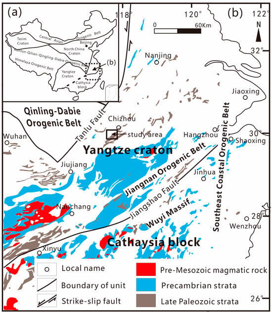
Figure 1.
(a) Tectonic outline map of China showing the location of the Lower Yangtze and its adjacent area. (b) Simplified geological diagram of the Lower Yangtze and its adjacent area showing distributions of main tectonic units and magmatic rocks and strata (modified after 1:5,000,000 geological diagrams of China (2002)).
In response to the provenance issue of the Permian Longtan Formation in the Lower Yangtze region, this study analyzed the geochemical characteristics of sandstone major and trace elements, as well as the paleocurrent indicators of sedimentary strata in the southern Anhui region. Combined with the analysis of the regional geological background in south China, the sedimentary source direction of the Longtan Formation and tectonic background in the source areas were studied to reconstruct the Late Permian source-to-sink system in the Lower Yangtze Basin.
2. Geological Setting
South China is divided into the Yangtze Block (craton) in the north and the Cathaysia Block in the south, with the Jiangshao Fault Zone as the boundary. The Wuyi Massif located in the Cathaysia Block and the Jiangnan orogenic belt located in the Yangtze Block (Craton) are distributed on both sides of the Jiangshao Fault Zone, while the southeastern coastal orogenic belt is distributed in the eastern region of south China (Figure 1). The formation of the Yangtze Block (craton) has gone through several major stages of tectonic evolution, including the formation of the Archean ancient land core, the formation of the Early–Middle Proterozoic ancient land block and craton basement, the formation of the Late Proterozoic–Paleozoic craton depression basin, the formation of the Mesozoic fault basin, and the formation of the Cenozoic continental margin foreland basin [41,42,43,44]. The Lower Yangtze region belonged to a cratonic intracontinental depression basin during the Paleozoic era and later underwent tectonic transformation from the Mesozoic to the Cenozoic era to form fault basins and foreland basins. During the Late Paleozoic era, the Dongwu Movement caused differential crustal uplift and large-scale seawater retreat in the Yangtze Block. The sedimentary environment in the Lower Yangtze region underwent significant changes from sea to land, but no large-scale volcanic activity occurred. The Lower Yangtze Basin and its surrounding areas are divided from north to south into the Jiaonan orogenic belt, Chuquan depression, Yangtze River depression, Wannan-Sunan depression, Jiangnan orogenic belt, and Qiantang depression [41,43]. The research area is located in the Yangtze River Depression in the eastern part of the Yangtze Craton (Lower Yangtze region).
After undergoing the formation of the basin and multiple subsequent tectonic transformations, the Lower and Middle Paleozoic and Mesozoic strata, with a thickness of over 10,000 m, developed in the Lower Yangtze region [41,42,43]. From the Late Devonian to the Middle Permian, the basin behaved as a passive continental-margin setting, in which deposition shifted from predominantly marine shales and carbonates to a Mid–Late Permian paralic system dominated by mixed clastic–carbonate strata with minor siliceous beds [34]. From bottom to top, the Permian succession in the study area comprises the Qixia, Gufeng, Longtan, and Dalong formations, overlain by the Yinkeng Formation of the Lower Triassic (Figure 2). The Longtan Formation is conformably bounded by the overlying Yinkeng Formation.
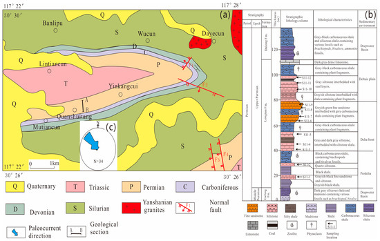
Figure 2.
(a) Geological map of Chizhou area in Lower Yangtze Region (modified after 1:200,000 geological map in Anqing). (b) Stratigraphic framework of the Longtan Formation in the sampling location. (c) Paleocurrent direction for Longtan Formation in the study area.
According to lithology and sedimentary characteristics (Figure 2b), the Longtan Formation can be divided into three sections from bottom to top: the lower section consists of thin to medium-thick layers of gray white, gray, brown yellow, gray yellow fine sand to siltstone, and black thin shale, interbedded with lenses of fine sandstone and sandy shale rich in pyrite nodules, mainly belonging to the prodelta sedimentary environment. The middle section consists of gray-white medium-grained feldspar quartz sandstone and gray and dark-gray fine sandstone, locally interbedded with calcareous shale and carbonaceous shale sections. The lithology is relatively stable and mainly belongs to the sedimentary environment of the delta front. The upper section consists of thin layers of gray-black shale and silty shale, interbedded with limestone. The limestone section is composed of deep-gray and gray-black pyrite containing nodular limestone, which is sometimes composed of siliceous limestone, argillaceous siliceous rock, or calcareous sandstone and shale interbedded with limestone convex mirror bodies. The coal-bearing section is mainly composed of dark-gray and gray-black shale, carbonaceous shale, silty shale interbedded with fine-grained sandstone, siltstone, feldspar quartz sandstone, and quartz sandstone, and contains two to five layers of coal with varying coal seam thicknesses. It mainly belongs to the sedimentary environment of the delta plain.
3. Samples and Methodology
3.1. Samples
The rock samples used in this study were collected from the geological section outcrop of the Longtan Formation in Quanshuitang Village, Chizhou City, Anhui Province, located in the Lower Yangtze Region (N: 30°27′34.58″, E: 117°24′4.05″) (Figure 2a,b). The lithologies include dark-gray, grayish-white, and yellowish-brown fine- to medium-fine-grained sandstones. After removing weathered and strongly altered portions, 12 fresh sandstone samples were selected for geochemical analysis based on petrographic identification under optical microscopy.
3.2. Elemental Analysis
Beijing Precambrian Technology Co., Ltd. (Beijing, China) initially pretreated the geochemical samples, including removing weathered surfaces, washing, and crushing to particles finer than 200 mesh. Subsequently, analyses of major and trace elements were conducted by Wuhan SampleSolution Analytical Technology Co., Ltd. (Wuhan, China). ZSX Primus II wavelength dispersive X-ray fluorescence spectrometer (XRF) produced by RIGAKU, Tokyo, Japan was used for the analysis of major elements in the whole rock following the Chinese national standard GB/T 14506.28-2010 [45]. All major element analysis lines are kα. The standard curve uses the national standard material [46]: rock standard sample GBW07101-14, soil standard sample GBW07401-08, stream sediment standard sample GBW07302-12. The data were corrected by the theoretical α coefficient method. The relative standard deviation (RSD) is less than 2%. Trace element concentrations were determined using an Agilent 7700e ICP-MS (Agilent Technology Co., Ltd., Santa Clara, CA, USA). Analytical errors were controlled within 5%.
4. Results
4.1. Major Element Oxides
Geochemical analysis revealed considerable variation in the significant element concentrations of the Longtan Formation sandstones from the Chizhou area (Table 1). SiO2 content ranges from 48.76% to 78.97%, with an average of 68.14%, which is comparable to the average values of post-Archean Australian shale (PASS) (SiO2 = 62.8%) and upper continental crust (UCC) (SiO2 = 66.62%) [47]. Al2O3 content ranges between 6.82% and 15.56%, with an average of 11.3%. Total Fe2O3 (Fe2O3T) ranges from 2.77% to 23.15%, with an average of 8.57%. Although a few samples showed elevated Fe2O3 levels, most are below the UCC average. TiO2 concentrations range from 0.31% to 0.82%, averaging 0.56%. K2O content ranges from 0.65% to 2.03% (average 1.29%) and MgO from 0.79% to 3.27% (average 1.59%). CaO content varies slightly, ranging from 0.27% to 1.15% with an average of 0.55%, and is generally lower than the UCC reference. The combined content of Fe2O3T and MgO ranges from 3.56% to 26.42%, averaging 10.16%. The wide range indicates the presence of a large amount of iron and magnesium components, which may come from certain minerals containing iron and magnesium components in the source rock or from minerals formed under the influence of later diagenesis, and their sources need further analysis. The SiO2/Al2O3 ratio ranges from 4.53 to 7.94 (average 6.22), K2O/Na2O ranges from 0.7 to 2.7 (average 1.15), and Fe2O3T/K2O shows a wide variation, ranging from 1.53 to 35.51.

Table 1.
Test results of major elements of sandstone from the Longtan Formation in the Chizhou area (wt/%).
As shown in the central element-normalized distribution patterns (Figure 3), the concentrations of principal oxides such as SiO2, TiO2, Al2O3, Fe2O3T, MgO, CaO, Na2O, K2O, and P2O5 in the Longtan Formation sandstones from the Chizhou area are generally comparable to those of PAAS. Among these, SiO2, Fe2O3T, MgO, and Na2O content is relatively enriched, and some elements exhibit a wide range of variability. In contrast, TiO2, Al2O3, CaO, K2O, and P2O5 are comparatively depleted. These results suggest that the Longtan Formation sandstones in the Chizhou area of the Lower Yangtze region contain relatively low amounts of unstable components and mafic-related minerals, indicating a high degree of compositional maturity. The provenance is likely dominated by intermediate to felsic source rocks.
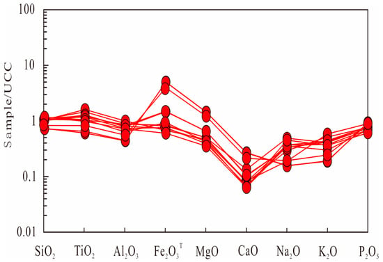
Figure 3.
Standardized spider diagram of major elements of sandstone from the Longtan Formation in the Chizhou area.
4.2. Trace Elements
Longtan Formation sandstone and Late Precambrian Australian shale (PAAS) both belong to the clastic rock class. Based on the data table of trace element content in Longtan Formation sandstone in the Chizhou area (Table 2) and its UCC-normalized distribution pattern (Figure 4a), the abundance and distribution pattern of trace elements in the sample are generally consistent with those in PAAS. For significant large ion lithophile elements (LILEs), which are geochemically more mobile, Longtan sandstones display significant variation in the content of Sc, V, Cr, Rb, and Ba, all of which are notably depleted relative to PAAS and UCC values. In contrast, Ni, Co, Sr, and Sm content vary to a lesser extent and is consistently lower than both PAAS and UCC averages. High-field-strength elements (HFSEs), such as Nb, Ta, Zr, Ce, Pb, Hf, Th, and U, are typically chemically immobile and resistant to metamorphism, hydrothermal alteration, weathering, and diagenesis. In the Longtan Formation sandstones, Nb, Zr, Hf, Ta, Ce, Th, and U concentrations exhibit substantial variability and are generally depleted relative to PAAS and UCC benchmarks.

Table 2.
Test results of trace elements of sandstone from the Longtan Formation in the Chizhou area (wt/10−6).
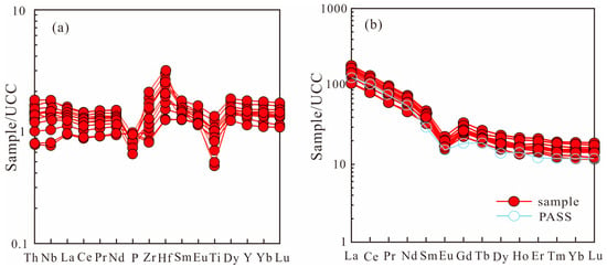
Figure 4.
Standardized spider diagram of trace elements (a) and REEs (b) of sandstone from the Longtan Formation in the Chizhou area (UCC standardized data from Taylor and McLennan, 1985).
The Late Paleozoic Longtan Formation sandstones in the Lower Yangtze region show enrichment in lithophile elements such as Li, Be, Rb, Ba, Cs, Th, and U. Chalcophile elements like Cd, Bi, and Pb. Rb (a large-ion lithophile element) and Th and U (LILEs) are relatively enriched. Elements that are depleted relative to the crustal averages include lithophile elements such as Sc and Sr, chalcophile elements such as Cr, Cu, and Ga, and siderophile elements such as Co and Ni. Except for the minor depletion of Cu and Ga, Sr and Ba (LILEs) and Nb and Ta (HFSEs) are strongly depleted. The Rb/Sr ratio ranges from 0.36 to 0.68, which is lower than that of PAAS (Rb/Sr = 0.8), which suggests that the Longtan Formation sandstones in Chizhou experienced limited chemical weathering and were likely transported over relatively short distances.
4.3. Rare Earth Elements
Rare earth element (REE) content of sandstone samples from the Longtan Formation in the Chizhou area, Lower Yangtze region, were analyzed, and the results are presented in Table 3. The total REE content (∑REE) is relatively low, ranging from 128.69 × 10⁻⁶ to 205.29 × 10⁻⁶, with an average of 169.72 × 10⁻⁶. These values are close to that of the UCC (148.1 × 10⁻⁶), but significantly higher than those of chondrites (3.953 ×10⁻⁶) and North American Shale composite (NASC) (3.89 × 10⁻⁶). The light rare earth element (∑LREE) content ranges from 110.86 × 10⁻⁶ to 183.15 × 10⁻⁶, with an average of 151.11 × 10⁻⁶. Heavy rare earth element (∑HREE) content varies from 15.06 × 10⁻⁶ to 23.22 × 10⁻⁶, averaging 18.61 × 10⁻⁶. The ∑LREE/∑HREE ratio ranges from 6.18 to 9.79, with an average of 8.15, slightly lower than the value for the UCC (9.36), indicating significant fractionation between LREEs and HREEs. The (La/Yb)n ratio, an index of LREE to HREE fractionation, ranges from 7.14 to 13.56, indicating significant enrichment in LREEs ((La/Yb)n > 1). The ∑LREE/∑HREE and (La/Yb)n ratios confirm a distinct fractionation between LREEs and HREEs in the Longtan Formation sandstones. The δEu values range from 0.49 to 0.56, with an average of 0.53, indicating a distinct negative Eu anomaly. These values are slightly lower than the averages for Phanerozoic cratonic sandstones (0.68) and the UCC (0.70). The δCe values range from 0.96 to 0.99, with an average of 0.97, suggesting a slightly negative, but generally near-normal Ce anomaly.

Table 3.
Test results of REEs of sandstone from the Longtan Formation in the Chizhou area (wt/10−6).
Based on the chondrite-normalized REE distribution patterns (Figure 4b), the Longtan Formation sandstone samples exhibit a fluctuating, right-inclined V-shaped curve. The La–Eu segment shows a steep slope, while the Dy–Lu segment appears relatively flat. A pronounced trough at Eu indicates a distinct negative Eu anomaly. The pattern resembles PAAS [47], characterized by enrichment in light REEs and relative depletion in heavy REEs, producing a rightward-sloping curve.
4.4. Bedding Orientation
Analysis of these sedimentary structures enables the interpretation of sediment dispersal patterns and the reconstruction of paleocurrent directions. This in turn provides insights into sediment provenance and supports the reconstruction of the paleogeographic framework. The strata contain well-developed sedimentary structures, including horizontal bedding, trough cross-bedding, and planar tabular cross-bedding (Figure 5).
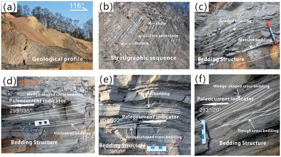
Figure 5.
Paleocurrent indicators of the Longtan Formation in the study area. (a) Geological profile of the Longtan Formation. (b) Stratigraphic sequence of the Longtan Formation. (c) Bedding structures such as massive bedding and graded bedding. (d) Bedding structures such as horizontal bedding and wedge-shaped cross-bedding. (e) Bedding structures such as wedge-shaped cross-bedding and parallel bedding. (f) Bedding structures such as trough cross-bedding and wedge-shaped cross-bedding.
Through detailed field observations of stratigraphic outcrops, small-scale cross-bedding structures were identified in the Longtan Formation sandstones at Quanshuitang Village, Chizhou City, Southern Anhui Province. A total of 34 cross-bedding datasets were measured (Table 4), with each record including both the attitude of sedimentary strata plane and the orientation of pre-interlayered plane in the cross-beds (Sc).

Table 4.
Attitudes of small cross-beddings in sandstone from the Longtan Formation in the Chizhou area.
Using Stereonet software (Software version 7.3.0), we applied horizontal restoration to the foreset dip directions of the measured cross-bedding sets. The corrected data were grouped at 10° azimuth intervals, and the relative percentage of each group was calculated to generate a paleocurrent rose diagram (Figure 2a,c).
To further constrain the compositional characteristics and provenance of the Longtan Formation, petrographic thin-section analysis was conducted on representative sandstone samples (Figure 6). Sample S11-3 (Figure 6a,d) shows a moderately sorted framework dominated by subangular quartz grains (Qtz), accompanied by plagioclase (Pl) and subordinate K-feldspar (Kfs), embedded in a compact matrix. Sample S11-4 (Figure 6b,e) displays relatively a number of lithic fragments (Ls) in addition to feldspar and quartz. Some minerals such as clay minerals and siderite mainly form the cement between clastic particles. This indicates derivation from intermediate to felsic igneous or sedimentary source rocks. Sample S11-1 (Figure 6c,f) contains a high proportion of angular to subangular quartz grains, plagioclase, and lithic clasts. It also contains a small amount of clay minerals and opaque minerals, mainly in the form of cement. Rocks have weak compaction and partial alteration characteristics.
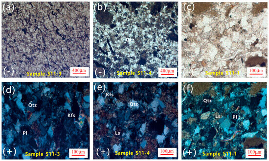
Figure 6.
Photomicrographs of the sandstone for the Longtan Formation in the study area. (a,d) Sample S11-3 photomicrograph. (b,e) Sample S11-4 photomicrograph. (c,f) Sample S11-1 photomicrograph. Abbreviations: Qtz, quartz; Pl, plagioclase; Kfs, K-feldspar; Ls, sedimentary lithic fragment; (-)plane polarized light; (+)cross-polarized light.
5. Discussion
5.1. Tectonic Setting
5.1.1. Weathering of Source Rock
Although the composition of source rocks in the provenance area fundamentally controls the mineralogical and geochemical characteristics of clastic sedimentary rocks, these rocks are often altered during sedimentation and diagenesis by a range of geological processes such as physical and chemical weathering, sedimentary sorting, and post-depositional diagenesis [48,49]. Sedimentary rocks undergoing intense chemical weathering and sedimentary recycling may exhibit significant deviations in their bulk geochemistry, leading to potential misinterpretations when inferring source rock characteristics [50,51]. To evaluate the degree of chemical weathering in sedimentary clastic rocks, geochemists commonly employ geochemical indices such as the Chemical Index of Alteration (CIA) and Chemical Index of Weathering (CIW), as well as diagrams based on primary elements (e.g., A–CN–K ternary plots) and trace element ratios (e.g., Th/U–Th, Th/Sc–Zr/Sc).
Higher CIA and CIW values indicate more intense chemical weathering of the source rock. Values ranging from 50 to 100 represent a continuum from unweathered to strongly weathered conditions in the source area [48]. As shown in Table 1, the CIA values of Longtan Formation sandstone samples range from 75.7 to 84.2 with an average of 79.43, and the CIW values range from 79.3 to 93.3 with an average of 85.82. The Al2O3–(CaO* + Na2O)–K2O (A–CN–K) ternary diagram is commonly used to evaluate the mobility of labile elements during chemical weathering of rocks [49]. As shown in the A–CN–K diagram in Figure 7, the Longtan Formation sandstone samples plot within the moderate weathering zone and the trend toward the illite and smectite fields, indicating progressive weathering and alteration of feldspars into i minerals.
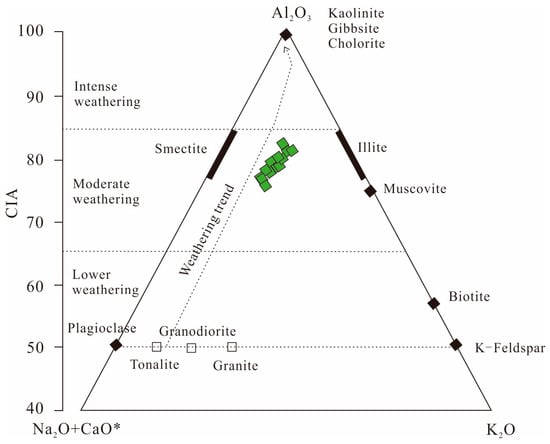
Figure 7.
A-CN-K ternary diagram of major earth elements of sandstone from the Longtan Formation in the Chizhou area (diagram based on [49]). CaO* represents the Ca content derived from silicate minerals in the rock, calculated in terms of oxide molar mass; CaO* = CaO − P2O5.
So-called sedimentary recycling refers to the transformation of some rock masses, such as diorite and granite, into minerals such as quartz, feldspar, montmorillonite, etc., during the weathering and transportation of rocks, forming sedimentary rocks. These sedimentary rocks further form new sedimentary rocks under external forces such as water flow. In addition, trace element diagrams such as Th/U–Th and Th/Sc–Zr/Sc are commonly used to evaluate the degree of chemical weathering. In general, Th, a large-ion lithophile element, tends to be enriched in felsic rocks, whereas Sc, a compatible element, is typically enriched in mafic rocks. The Th/Sc ratio is relatively insensitive to sediment recycling. At the same time, Zr, primarily hosted in zircon—a highly stable mineral—accumulates during sedimentary recycling and is generally unaffected by hydrothermal alteration [51]. Therefore, the Th/Sc–Zr/Sc plot is widely used to indicate sedimentary recycling in clastic rocks. As shown in the Th/Sc–Zr/Sc diagram in Figure 8, most sandstone samples from the Longtan Formation plot near the compositional evolution line and do not display a significant trend of sedimentary recycling, indicating that the nature of the source rocks primarily controls the sandstone composition. These findings suggest that the Late Paleozoic Longtan Formation sandstones in the Lower Yangtze region did not undergo intense chemical weathering or multistage sedimentary recycling, but experienced moderate weathering. This implies a likely distal sediment source and deposition following relatively long-distance transport.
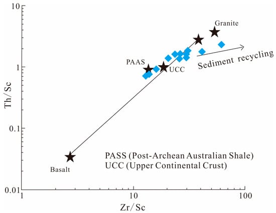
Figure 8.
Th/Sc-Zr/Sc diagram of trace earth elements of sandstone from the Longtan Formation in the Chizhou area (diagram based on [51]).
5.1.2. Type of Source Rock
Provenance characteristics of sedimentary rocks can be inferred from multi-element geochemical discrimination diagrams [52,53]. Terrigenous clastic sediments are classified into four source categories: mafic volcanic, intermediate volcanic, felsic volcanic, and quartzose sedimentary provenance. They developed provenance discrimination functions based on the relationships among principal oxides such as Ti, Al, Fe, Mg, Ca, Na, and K. As shown in the F1–F2 (Table 1) discrimination diagram (Figure 9), most sandstone samples from the study area plot within the intermediate igneous provenance field, with a few falling into the mafic igneous provenance field. This suggests that the source area of the Longtan Formation sandstones in Chizhou may have been linked to a tectonically active region dominated by mafic to intermediate volcanic rocks. An Al2O3/TiO2 ratio greater than 14 in sedimentary rocks indicates a predominantly felsic provenance. As shown in Table 1, the average Al2O3/TiO2 ratio for the sandstone samples is 20.21, indicating that the Longtan Formation was mainly derived from felsic source rocks.
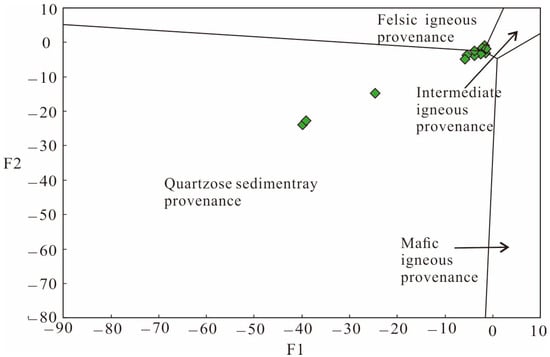
Figure 9.
Provenance discrimination function diagram on major elements for sandstones of Longtan Formation in the Chizhou area (diagram based on [53]).
The La/Th–Hf diagram can be a reliable indicator for determining sedimentary provenance. Plotting the La/Th and Hf values of the Longtan Formation sandstone samples shows that most data points fall within the felsic provenance field, indicating an upper continental crustal source (Figure 10). The geochemical analysis was performed using an open-system four-acid digestion method, which may not completely dissolve refractory minerals hosting Hf and Zr. As a result, the measured concentrations of Hf and Zr may be underestimated and should be interpreted cautiously. When adjusting the Hf concentrations upward to compensate for potential underestimation, the data points remain within the felsic provenance region, trending toward a passive continental margin source. These results suggest that the Longtan Formation in the Chizhou area was predominantly derived from felsic upper continental crustal rocks.
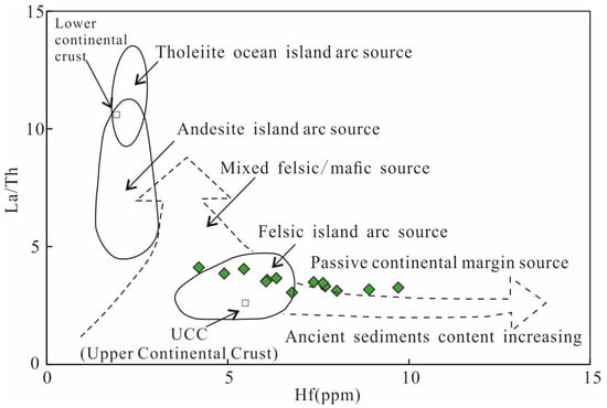
Figure 10.
Th/Sc-Zr/Sc diagram of trace-earth elements of sandstone from the Longtan Formation in the Chizhou area (diagram based on [54]).
Many trace elements, such as Zr, Y, Th, Sc, Hf, and Ti, are considered immobile during sedimentary processes and are reliable indicators of source rock types in clastic sedimentary rocks [55,56]. Multi-element discrimination diagrams have proven effective in evaluating the source rock characteristics of clastic sedimentary rocks, including TiO2–Al2O3, TiO2–Zr, K2O–Rb, and TiO2–Ni. Based on the geochemical data of sandstone samples from the Longtan Formation, the following observations can be made from Figure 10. In the TiO2–Al2O3 diagram (Figure 11a), the data points mainly fall within the granite and basalt fields. Most samples in the TiO2–Zr plot (Figure 11b) are in the felsic igneous rock domain. The data points in the K2O–Rb diagram (Figure 11c) follow a magmatic differentiation trend, indicating a predominantly felsic source. The samples in the TiO2–Ni plot (Figure 11d) predominantly plot in the acidic and calcareous sandstone fields. These diagrams collectively suggest a geochemically diverse provenance for the Longtan Formation in the Chizhou area. The samples plot away from the mafic (ferromagnesian) field, implying a source dominated by intermediate to felsic igneous rocks, such as granites, andesites, and possibly dacites or rhyolites.
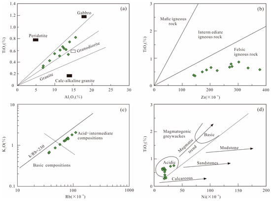
Figure 11.
Geochemical classification of sandstones of Longtan Formation in the Chizhou area. (a) TiO2-Al2O3 diagram (diagram based on [57]); (b) TiO2-Zr diagram (base diagram after [58]); (c) Rb-K2O diagram (diagram based on [54]); (d) Ni-TiO2 diagram (diagram based on [59]).
5.1.3. Tectonic Environment of Source Rock
To a certain extent, the geochemical characteristics of elements can reflect the source-rock types and tectonic settings of clastic rocks within sedimentary basins. The combination of primary, trace, and REE data from stratigraphic rocks can be used to infer the provenance tectonic setting [51,56]. Bhatia and Roser summarized that sandstones formed in different tectonic settings—such as oceanic island arc (OIA), continental island arc (CIA), active continental margin (ACM), and passive margin (PM)—exhibit systematic variations in major element geochemistry. Their studies concluded that during the tectonic evolution from OIA to PM settings, TiO2, total Al2O3 + MgO content, and Al2O3/SiO2 ratios in sandstones tend to decrease, while K2O/Na2O and Al2O3/(CaO + Na2O) ratios gradually increase [51,53].
Geochemical tectonic discrimination diagrams are widely used to distinguish the tectonic settings of clastic sedimentary rocks and have been applied here to assess the Longtan Formation sandstones in the Lower Yangtze region. In the Fe2O3 + MgO vs. TiO2 and Fe2O3 + MgO vs. Al2O3/SiO2 discrimination diagrams (Figure 12a,b), most samples plot within the active continental margin (ACM) and continental island arc (CIA) fields. In the K2O/Na2O vs. SiO2 and K2O/Na2O vs. SiO2/Al2O3 diagrams (Figure 12c,d), the samples are distributed primarily in the active and passive continental margin (PCM) domains, with a few extending toward the island arc domain. These consistent trends support the interpretation of a tectonically active provenance, dominated by upper continental crust and associated island arcs during Late Permian sedimentation.
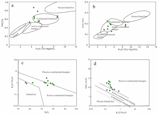
Figure 12.
Tectonic setting discrimination on major elements of the sandstones from Longtan Formation in the Chizhou area ((a,b) diagram based on [55]; (c,d) diagram based on [52]).
Certain trace elements in clastic sedimentary rocks, such as La, Co, Nd, Y, Th, Zr, Hf, Nb, Ti, and Sc, are primarily controlled by the composition of the source rocks and are minimally affected by subsequent sedimentary and diagenetic processes. As a result, they retain valuable geochemical signatures of the original provenance [56,60,61,62,63,64]. Owing to their immobile nature, these trace elements can be effectively used to assess the tectonic setting in which the source rocks of the sedimentary basin were formed.
Combinations of trace elements such as La, Co, Nd, Y, Th, Zr, Hf, Nb, Ti, and Sc in clastic sedimentary rocks can distinguish tectonic settings [65]. Specific trace element discrimination diagrams differentiate four tectonic settings: oceanic island arc, continental island arc, active continental margin, and passive continental margin [65]. The trace element data of Permian sandstones from the Longtan Formation in the Lower Yangtze region were plotted on Ti/Zr–La/Sc, La–Th–Sc, and Th–Sc–Zr/10 diagrams (Figure 13). The results indicate that the provenance of the Longtan Formation sandstones is predominantly related to active continental margin and continental island arc settings, with minor influence from passive continental margin environments.
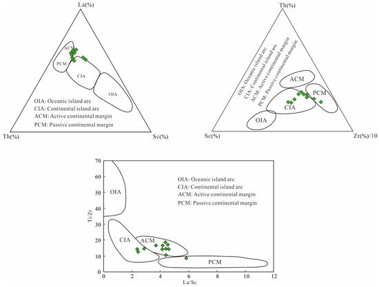
Figure 13.
Tectonic setting diagrams of trace elements (Ti/Zr-La/Sc, La-Th-Sc, Th-Sc-Zr/10) of the sandstone of Longtan Formation in the Chizhou area (diagram based on [65]).
The immobile behavior of REEs allows them to preserve geochemical signatures indicative of provenance and tectonic setting in clastic sedimentary rocks [56]. He established typical REE distribution patterns for different tectonic environments. In the chondrite-normalized REE distribution diagrams, the REE patterns of the Longtan Formation sandstones closely resemble the classic tectonic setting models for active and passive continental margins [56]. A comparison of REE parameters for the Longtan Formation sandstones with reference values for sandstones from different tectonic settings (Table 5) shows that La and Ce content, total REE (∑REE), and LREE/HREE ratios are similar to those in active continental margin settings. In contrast, La/Yb, (La/Yb)n, and δEu values are more consistent with passive margin environments. These results suggest that the Longtan Formation in the Upper Permian of the Lower Yangtze region was mainly derived from an active continental margin setting, with minor influence from a passive margin provenance. In summary, geochemical analyses of major elements, trace elements, and REEs indicate that the Longtan Formation sandstones in the Lower Yangtze region were primarily derived from active continental margin and continental island arc settings, with a minor contribution from passive continental margins.

Table 5.
REE characteristic of greywacke of the various tectonic settings in sedimentary basins.
5.2. Source Area Analysis
5.2.1. Paleo-Uplifts and Erosion Area
During the Late Permian period, the Yangtze region was in the stage of formation and evolution of craton basins and foreland basins, with a series of paleo-uplift and erosion zones around the basin periphery. The northern region has the Huaiyang paleo-uplift (belonging to the Qinling Dabie orogenic belt), the western region has the Yunkai and Kangdian paleo-uplift (belonging to the Songpan Ganzi orogenic belt), the southern region has the Jiangnan paleo-uplift (also known as the Jiangnan orogenic belt, belonging to the Yangtze Craton), the southeastern region has the Wuyi Massif (belonging to the Cathaysia Block), and the eastern region has developed Late Paleozoic volcanic rock belts. These paleo-uplift and erosion zones are potential source areas for the Longtan Formation strata in the Lower Yangtze region.
The Songpan Ganzi orogenic belt is located on the western edge of the Yangtze Block, approximately 2000 km from the Lower Yangtze region. Although this unit functioned as an inherited uplift zone during the Late Paleozoic, with paleo-uplifts such as the Yunkai and Kangdian terranes potentially providing clastic material to surrounding basins, this source is unlikely to have contributed significantly to the Longtan Formation in the Lower Yangtze region. During the Late Permian, the entire Yangtze Block was a surface sea basin submerged by seawater [66] and the Lower Yangtze area was located below sea level, receiving marine and marginal-marine deposits. Given the vast geographic distance between the western paleo-uplifts and the Lower Yangtze depositional center, as well as the lack of sedimentary pathways capable of supporting long-distance transport of terrigenous clastics in a marine-dominated setting, it is reasonable to exclude the Yunkai and Kangdian paleo-uplifts of the Songpan–Ganzi belt as potential source areas for the Longtan Formation.
The Qinling Dabie orogenic belt is a suture zone formed by the closure of the Paleo-Qinling Ocean (part of the Paleo-Tethys) between the North China Plate and the Yangtze Plate. Research has shown that the final closure and collision for two plates occurred after the Late Permian period [67,68,69]. The orogenic belt (Dabie Sulu orogenic belt) located in the northern part of the Lower Yangtze was mainly formed during the Indosinian orogeny in the Late Permian to the Early Triassic. This indicates that the Paleo-Qinling Ocean still existed between the Yangtze and North China plates during the sedimentation period of the Longtan Formation in the Late Permian. Consequently, the Dabie Sulu orogenic belt cannot have been the source area of the Longtan Formation in the Lower Yangtze region.
The Jiangnan orogenic belt, also referred to as the “Jiangnan Island arc belt” or “Jiangnan old land,” is an accretionary orogenic belt formed on the southern edge of the Yangtze Block during the Mesoproterozoic to Neoproterozoic periods. Research suggests that the belt has been a paleo-uplift and erosion zone since the Devonian period based on the analysis of the composition of sandstone debris in the Longtan Formation [37]. Therefore, the Jiangnan orogenic belt is likely to have provided clastic material to the Longtan Formation during the Late Permian.
There are two potential source areas in the southeastern part of the research area. One type is the Wuyi Massif. After the merger of the Yangtze and the Cathaysia Block, the Lower Yangtze region underwent intracontinental orogeny (Dongwu Movement), resulting in the exposure of Precambrian basement rocks and Paleozoic strata in the Wuyi Massif [70,71]. These uplifted and exposed rocks may have become important sources for the Lower Yangtze sedimentary basin. The other type is the Late Paleozoic magmatic arc on the eastern marge of South China, which is an island arc belt formed by the subduction of the ancient Pacific plate to the South China plate in the Late Paleozoic era [72,73,74]. This magmatic rock belt may provide a sedimentary source for the Longtan Formation in the Yangtze region during the Late Permian. Therefore, there may be two types of provenance in the southeast direction of the Longtan Formation in the Lower Yangtze region, namely the Wuyi paleo-uplift area and the eastern marge magmatic arc zone.
5.2.2. Source Direction
Based on stratigraphic and paleontological evidence from the northern Lower Yangtze region, some researchers have argued that there was no independent Huaiyang old land during the Late Paleozoic. Instead, the Huaiyang area was part of a sedimentary trough associated with the northern branch of the Paleo-Tethys Ocean, as evidenced by the sporadic occurrence of Late Paleozoic strata and fossil assemblages in the Dabie Mountains and the distribution of the Permian strata in the Huaiyang area [75]. Lithofacies-paleogeographic reconstructions of the Lower Yangtze region suggest that the Longtan Formation thins northwestward from southeastern to northwestern areas, with a transitional depositional setting between marine and terrestrial environments. The depocenter was likely located in the Changxing region of Zhejiang Province [13]. Furthermore, geophysical seismic reflection data have been used to identify delta-front sheet- and lobe-shaped sandstone bodies distributed from southeast to northwest, indicating that the Longtan Formation consists of a series of southeast-derived, northwest-prograding deltaic sand bodies. Collectively, stratigraphic thickness patterns, paleogeographic reconstructions, and geophysical interpretations all suggest a Late Permian (Wujiaping to Changxing stages) paleogeographic configuration in which landmasses were located to the south and southeast of the sedimentary basin and the marine domain lay to the north. This indicates probable sediment transport direction from the southeast to the northwest. This study conducted detailed field measurements of cross-bedding structures in the Longtan Formation in Quanshuitang village, southern Anhui. The resulting paleocurrent pattern indicates a predominant northwestward flow direction, supporting the interpretation that the sediment source area was located to the southeast [76].
Therefore, based on comprehensive analyses of the regional tectonic framework, stratigraphic sedimentary structures, sandstone geochemical compositions, and petrographic characteristics, it is inferred that during the Permian, the Lower Yangtze region exhibited a paleogeographic pattern characterized by a southern landmass and a northern marine domain. The Jiangnan Orogen and the Wuyi Massif, located in the southern part of the region, acted as uplifted erosional source areas. Igneous rocks and ancient sedimentary strata distributed across these uplifts were subjected to chemical weathering and physical erosion, generating clastic material transported northward by paleocurrents into the Lower Yangtze sedimentary basin. Paleocurrent data and the geochemical signatures of the sandstones further support this interpretation. Accordingly, the Jiangnan Orogen and the Wuyi Massif represent the most plausible provenance areas for the clastic material comprising the Longtan Formation in the Lower Yangtze region.
5.3. Tectonic Evolution of the Paleo-Tethys and Paleogeographic Reconstruction
The tectonic evolution of the Paleo-Tethys Ocean exerted a fundamental control on the paleogeographic configuration and sedimentary systems of South China during the Late Paleozoic. In the Permian, the Paleo-Tethys Ocean was situated between the South China Block and the North China Block to the north. Its evolution led to the development of a complex convergent margin system, including foreland basins, accretionary arcs, and back-arc basins. Southward subduction of the Paleo-Tethyan oceanic plate beneath the South China Block initiated the closure of the ocean and produced a compressional tectonic regime along the northern edge of the Yangtze Craton. This convergence induced crustal shortening, lithospheric flexure, and the formation of peripheral foreland basins such as the Lower Yangtze Basin. The Longtan Formation, deposited during the Late Permian, represents a key stratigraphic record of this tectonic context and the final phase of Paleo-Tethyan marginal sedimentation in this region.
Paleogeographic reconstructions for the Wuchiapingian to Changhsingian stages indicate that the Lower Yangtze region developed a transitional marine–continental setting. Uplifted source regions, including the Jiangnan Orogen and Cathaysia terranes to the south and southeast, supplied a mount of terrigenous clastic material. These sediments were transported by northwest-directed paleocurrents and deposited in a shallow-marine to deltaic environment, forming a classic “south land–north sea” pattern (Figure 14). The deltaic system exhibited clear progradation from southeast to northwest, as supported by stratigraphic thinning, paleocurrent analysis, and seismic interpretations.
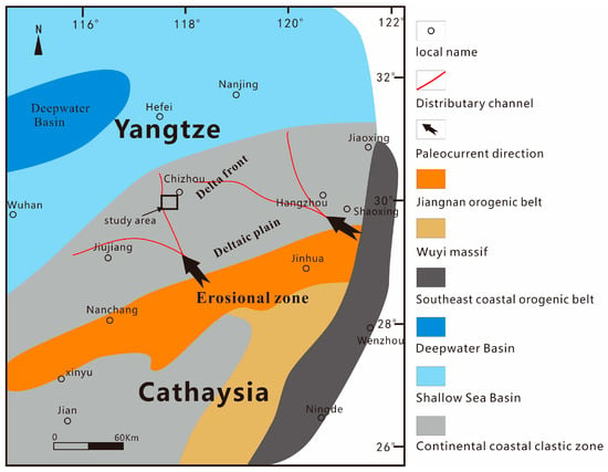
Figure 14.
Paleogeographic sketch map of the Lower Yangtze and its adjacent area for the Wuchiapingian to Changhsingian stages showing “south land–north sea” pattern.
This depositional framework reflects a tectonically coupled source-to-sink system, where sediment supply, accommodation space, and dispersal direction were all governed by basin-margin compression and Paleo-Tethyan convergence. The Longtan Formation thus provides important geological evidence for understanding foreland basin evolution along the Paleo-Tethyan margin. Although the present study has provided a comprehensive interpretation of provenance and tectono-sedimentary interactions based on integrated sedimentological and geochemical analyses, further work is required to refine the temporal evolution of source-to-sink processes. Future studies should aim to conduct high-resolution stratigraphic sampling and integrate quantitative provenance tools—such as detrital zircon U–Pb geochronology, Lu–Hf isotopes, and heavy mineral assemblage analysis—to unravel the shifts in sediment supply and basin dynamics over time. Such efforts will help reconstruct the detailed tectonic and paleoenvironmental history of the Permian in the Lower Yangtze region and offer broader insights into sedimentation processes in convergent margin settings globally.
6. Conclusions
(1) The Permian Longtan Formation sandstones in the Chizhou area exhibit high SiO2, Al2O3, and K2O and relatively low MgO and Fe2O3 (except in samples with a mount of siderite cement). LILEs such as Rb and Sr are relatively enriched, while HFSEs, including Cr, Ni, Zr, and Hf, are depleted. The REE patterns show enrichment in LREEs and depletion in HREEs, with strongly right-inclined patterns and pronounced negative Eu anomalies. These geochemical characteristics closely resemble those of the UCC.
(2) The provenance of the Longtan Formation sandstones in the Chizhou area of the Lower Yangtze is likely related to tectonically active regions dominated by mafic to intermediate volcanic rocks. The depositional setting corresponds to an active continental margin and continental island arc environment, with felsic rocks from the UCC serving as the primary source material.
(3) Sedimentological, paleogeographic, and geophysical evidence indicates that during the Wuchiapingian–Changhsingian stages of the Late Paleozoic, the Lower Yangtze region exhibited a paleogeographic configuration of northern sea and southern land. Clastic sediments were primarily derived from the basin’s southern part, suggesting that the Jiangnan Orogen and the Wuyi Massif of the Cathaysian block were the main provenance areas.
Author Contributions
Conceptualization, S.D. and D.H.; formal analysis, W.M.; writing—original draft preparation, S.D. and D.H.; writing—review and editing, S.D. and D.H. All authors have read and agreed to the published version of the manuscript.
Funding
This research received no external funding.
Data Availability Statement
Data are available from the authors upon request.
Acknowledgments
We are grateful to the three anonymous reviewers for providing valuable revision suggestions. We also thank Xia Yutian for his support during the field work and helping to process the drawings. We have consulted and discussed with You Guoqing multiple times during the writing process so that the manuscript has been greatly improved from his critical reviews and have benefited greatly. We would like to express our gratitude.
Conflicts of Interest
Author Wenli Ma was employed by the companies CNPC Central Asia and Russia and China National Oil and Gas Exploration and Development Corporation Ltd. The remaining authors declare that the research was conducted in the absence of any commercial or financial relationships that could be construed as a potential conflict of interest.
References
- Dickinson, W.R.; Suczek, C.A. Plate tectonics and sandstone compositions. AAPG Bull. 1979, 63, 2164–2182. [Google Scholar] [CrossRef]
- Dickinson, W.R.; Beard, L.S.; Brakenridge, G.R. Provenance of north American Phanerozoic sandstones in relation to tectonic setting. Geol. Soc. Am. Bull. 1983, 94, 222–235. [Google Scholar] [CrossRef]
- Mack, G.H. Exceptions to the relationship between plate tectonics and sandstone composition. J. Sediment. Petrol. 1984, 54, 212–220. [Google Scholar]
- Baker, J.C.; Fielding, C.R.; Caritat, P.D.; Wilkinson, M.M. Permian evolution of sandstone composition in s complex back-arc extensional to Foreland Basin: The Bowen Basin, Eastern Australis. J. Sediment. Petrol. 1993, 63, 881–893. [Google Scholar]
- Pearce, J.A.; Cann, J.R. Tectonic setting of basic volcanic rocks determined using trace element analyses. Earth Planet. Sci. Lett. 1973, 19, 290–300. [Google Scholar]
- Winchester, J.A.; Floyd, P.A. Geochemical discrimination of different magma series and the differentiation products using immobile elements. Chem. Geol. 1977, 20, 325–343. [Google Scholar] [CrossRef]
- Wood, D.A.; Joson, J.L.; Treuil, M. A reappraisal of the use of trace elements to classify and discriminate between magma series erupted in different tectonic settings. Earth Planet. Sci. Lett. 1979, 45, 326–336. [Google Scholar] [CrossRef]
- Bailey, J.C. Geochemical criteria for a refined tectonic discrimination of orogenic andesites. Chem. Geol. 1981, 32, 139–154. [Google Scholar] [CrossRef]
- Ahmed, N.; Siddiqui, N.A.; Ramasamy, N.; Ramkumar, M.; Jamil, M.; Usman, M.; Sajid, Z.; Rahman, A.H.B.A. Geochemistry of Eocene Bawang Member turbidites of the Belaga Formation, Borneo: Implications for provenance, palaeoweathering, and tectonic setting. Geol. J. 2021, 56, 2477–2499. [Google Scholar] [CrossRef]
- Getaneh, W. Geochemistry provenance and depositional tectonic setting of the Adigrat Sandstone northern Ethiopia. J. Earth Sci. 2002, 35, 185–198. [Google Scholar] [CrossRef]
- Yang, R.C.; Li, J.B.; Fan, A.P.; Zong, M.; Zhang, T. Research progress and development tendency of provenance analysis on terrigenous sedimentary rocks. Acta Sedimentol. Sin. 2013, 31, 99–107, (In Chinese with English abstract). [Google Scholar]
- Xu, J.; Jiang, Z.X. Provenance Analysis of Clastic Rocks: Current Research Status and Prospect. J. Palaeogeogr. 2019, 21, 379–396, (In Chinese with English abstract). [Google Scholar]
- Feng, Z.Z.; He, Y.B.; Wu, S.H. Lithofacies and Palaeogeography of Permian of Middle and Lower Yangtze Region; Geological Publishing House: Beijing, China, 1991. (In Chinese) [Google Scholar]
- Wang, W.Y. The Longtan Formation in the Suzhou-Zhejiang-Anhui Region. J. Stratigr. 1993, 17, 232–336. (In Chinese) [Google Scholar]
- Wang, W.Y. Sedimentary Facies of the Maokou Stage and Upper Permian in the Suzhou-Zhejiang-Anhui Region. Lithofacies Palaeogeogr. 1998, 18, 36–42. (In Chinese) [Google Scholar]
- Zhang, K.X.; Liu, J.H.; He, W.H.; Wu, S.B. Sequence Stratigraphy of the Permian Outcrops in the Middle and Lower Yangtze Region. Earth Sci. 2002, 27, 357–365. (In Chinese) [Google Scholar]
- Mei, L.F.; Dai, S.W.; Shen, C.B.; Tang, J.G. Formation and Disintegration of the Mesozoic–Cenozoic Intra-Continental Ramp Zone in the Middle and Lower Yangtze Region. Geol. Sci. Technol. Inform. 2008, 27, 1–7. (In Chinese) [Google Scholar]
- Ding, D.G.; Wang, D.Y.; Liu, Y.L. Transformation and deformation of the Paleozoic basins in lower Yangtze areas. Earth Sci. Front. 2009, 4, 61–73. (In Chinese) [Google Scholar]
- Pan, Y.; Dong, P. The Lower Changjiang (Yangzi/Yangtze River) metallogenic belt, East Central China: Intrusion-and wall rock-hosted Cu-Fe-Au, Mo, Zn, Pb, Ag deposits. Ore Geol. Rev. 1999, 15, 177–242. [Google Scholar] [CrossRef]
- Liang, D.G.; Guo, T.L.; Chen, J.P.; Bian, L.Z.; Zhao, Z. New Advances in the Study of Marine Hydrocarbon Generation and Accumulation in Southern China (I): Distribution of Four Sets of Regional Marine Source Rocks. Mar. Orig. Pet. Geol. 2008, 13, 1–16. (In Chinese) [Google Scholar]
- Pan, J.P.; Qiao, D.W.; Li, S.Z.; Zhou, D.S.; Xu, L.F.; Zhang, M.Y.; Song, X.Y. Shale-gas geological conditions and exploration prospect of the Paleozoic marine strata in lower Yangtze area, China. Geol. Bull. China 2011, 30, 337–343. (In Chinese) [Google Scholar]
- Xu, K.D. Upper Permian Longtan sequence stratigraphy, paleogeography and Leping coal in Northeastern Jiangxi Province. Mar. Orig. Petrol. Geol. 2012, 17, 34–44. (In Chinese) [Google Scholar]
- Li, J.Q.; Pu, R.H.; Wu, Y.; Tian, Y.Y. Sedimentary characteristics and favorable reservoir prediction of Longtan Formation in Huangqiao area, Jiangsu Province. Pet. Geol. Exp. 2012, 34, 395–399. (In Chinese) [Google Scholar]
- Shao, L.Y.; Zhang, C.; Yan, Z.M.; Dong, D.X.; Gao, C.X.; Li, Y.J.; Xu, X.Y.; Liang, W.L.; Yi, T.S.; Xu, X.H.; et al. Sequence Stratigraphy, Paleogeography, and Coal Accumulation Patterns during the Late Permian in South China. J. Palaeogeogr. 2016, 18, 905–919, (In Chinese with English abstract). [Google Scholar]
- Li, Z.X.; Li, X.H. Formation of the 1300-km-wide intracontinental orogen and postorogenic magmatic province in Mesozoic South China: A flat-slab subduction model. Geology 2007, 35, 179–182. [Google Scholar] [CrossRef]
- Xu, Y.; Du, Y.; Cawood, P.A.; Zhu, Y.H.; Li, W.C.; Yu, W.C. Detrital zircon provenance of Upper Ordovician and Silurian strata in the northeastern Yangtze Block: Response to orogenesis in South China. Sediment. Geol. 2012, 267–268, 63–72. [Google Scholar] [CrossRef]
- Li, H.B.; Jia, D.; Wu, L.; Zhang, Y.; Yin, H.W.; Wei, G.Q.; Li, B.L. Detrital zircon provenance of the Lower Yangtze foreland basin deposits: Constraints on the evolution of the early Palaeozoic Wuyi-Yunkai orogenic belt in South China. Geol. Mag. 2013, 150, 959–974. [Google Scholar] [CrossRef]
- Yao, W.H.; Li, Z.X.; Li, W.X.; Su, L.; Yang, J.H. Detrital provenance evolution of the Ediacaran-Silurian Nanhua foreland basin, South China. Gondwana Res. 2015, 28, 1449–1465. [Google Scholar] [CrossRef]
- Sun, J.; Wang, J.Q.; Gong, J.M. Organic Matter Abundance and Lithofacies Palaeogeography of Marine Source Rocks in the Middle–Paleozoic of the Lower Yangtze Land Area. Mar. Geol. Front. 2016, 32, 22–28, (In Chinese with English abstract). [Google Scholar]
- Ma, Y.S.; Chen, H.D.; Wang, G.L. Tectono-Sequence Lithofacies Paleogeographic Atlas of South China; Science Press: Beijing, China, 2009. (In Chinese) [Google Scholar]
- Bai, L.H.; Shi, W.Z.; Zhang, X.M.; Xu, X.F.; Liu, Y.Z.; Yang, Y.; Feng, X.; Cao, S.T. Characteristics and Sedimentary Environment of the Permian Marine Shale in the Xu–Jing Area, Southern Anhui, Lower Yangtze Region. Earth Sci. 2021, 46, 2204–2217, (In Chinese with English abstract). [Google Scholar]
- Huang, Z.Q. Tectonic Evolution of the Lower Yangtze Basin and the Main Shale Gas Enrichment Horizons. Shanghai Land. Resour. 2017, 38, 87–92. (In Chinese) [Google Scholar]
- Gao, S.L.; Tan, S.Z.; Chen, C.F.; Zhou, P. Lithofacies Palaeogeography of the Permian in the Lower Yangtze–South Yellow Sea Area and Its Implications for Hydrocarbon Exploration. Mar. Geol. Front. 2021, 37, 53–60, (In Chinese with English abstract). [Google Scholar]
- Feng, S.N.; Zhang, G.X. Overview of Lithofacies Paleogeography during the Permian in South China. Bull. Yichang Inst. Geol. Min. Res. CAGS 1994, 20, 113–124. (In Chinese) [Google Scholar]
- Zhou, X.J. Tectono-Sequence Lithofacies Paleogeography of the Permian in Southern China. Ph.D. Thesis, Central South University, Changsha, China, 2009. (In Chinese). [Google Scholar]
- Zhang, C. Sequence Stratigraphy, Palaeogeography, and Coal Accumulation Patterns During the Late Permian in South China. Ph.D. Thesis, China University of Mining and Technology (Beijing), Beijing, China, 2013. (In Chinese). [Google Scholar]
- Du, Y.L.; Li, S.Y.; Kong, W.L.; Wang, S. Detrital Composition and Provenance Analysis of the Permian Longtan Formation Sandstones in Southeastern Anhui. J. Univ. Geosci. 2010, 16, 509–516, (In Chinese with English abstract). [Google Scholar]
- Qiu, M.; Wu, X.J.; Zhang, P.F. Sandstone Types and Heavy Mineral Characteristics of the Late Permian Longtan Formation in the Yangqiao Mining Area, Jiangxi Province. J. China Coal Soc. 1989, 3, 66–75. (In Chinese) [Google Scholar]
- Xu, W.L.; Zheng, R.C.; Yan, X.; Wen, H.G.; Cui, C. Geochemical Characteristics and Geological Implications of the Early Paleozoic Black Rock Series in the Lower Yangtze Region. Jilin Univ. J. Earth Sci. Ed. 2014, 44, 1108–1122, (In Chinese with English abstract). [Google Scholar]
- Li, C.; Lü, X.; Hu, X.M.; Yu, J.H.; Sun, G.Y. Provenance Analysis of Lower Yangtze Sandstones Provides New Evidence for a Late Paleozoic Continental Arc along the Southeastern Coast of China. Chin. Sci. Bull. 2017, 62, 2951–2966, (In Chinese with English abstract). [Google Scholar]
- Zhu, G.; Xu, J.W.; Liu, G.S.; Liu, G.S.; Li, S.Y.; Yu, P.Y. Structural Pattern and Dynamic Mechanism of Foreland Deformation in the Lower Yangtze Region. Reg. Geol. China 1999, 18, 73–79. (In Chinese) [Google Scholar]
- Du, X.D.; Huang, Z.C.; Chen, Z.N.; Liu, J.R. Division and correlation of the Permian sequence in lower Yangtze Region. J. Stratigr. 1999, 23, 152–160. [Google Scholar]
- Ye, Z.; Liang, X.; Ma, L.; Zhang, T.S.; Xu, K.D. The Independent Block of the Lower Yangtze and Mesozoic Modified Residual Basins. Geol. Sci. 2006, 41, 81–101. (In Chinese) [Google Scholar]
- Zhang, G.W.; Guo, A.L.; Wang, Y.J.; Li, S.Z.; Dong, Y.P.; Liu, S.F.; He, D.F.; Cheng, S.Y.; Lu, R.K.; Yao, A.P. Tectonic Framework and Key Issues of the South China Continental Domain. Sci. China 2013, 43, 1553–1582, (In Chinese with English abstract). [Google Scholar]
- GB/T 14506.28-2010; Methods for Chemical Analysis of Silicate Rocks-Part 28: Determination of 16 Major and Trace Elements Content (China National Standardization Administration). China Standard Press: Beijing, China, 2010.
- GBW07101-14; Certificate of Certified Reference Material. National Standard Material Resource Sharing Platform; China Standard Press: Beijing, China, 1990.
- Balaram, V.; Santosh, M.; Satyanarayanan, M.; Srinivas, N.; Gupta, H. Lithium: A review of applications, occurrence, exploration, extraction, recycling, analysis, and environmental impact. Geosci. Front. 2024, 15, 101868. [Google Scholar] [CrossRef]
- Nesbitt, H.W.; Young, G.M. Early Proterozoic climates and plate motions inferred from major element chemistry of lutites. Nature 1982, 299, 715–717. [Google Scholar] [CrossRef]
- Fedo, C.M.; Wayne Nesbitt, H.; Young, G.M. Unraveling the effects of potassium metasomatism in sedimentary rocks and paleosols, with implications for paleoweathering conditions and provenance. Geology 1995, 23, 921–924. [Google Scholar] [CrossRef]
- Zhang, J.L.; Zhang, X. Geochemical Characteristics of Silurian Sandstones in the Tazhong Area and Their Implications for Provenance Discrimination. Acta Petrol. Sin. 2007, 23, 2990–3002, (In Chinese with English abstract). [Google Scholar]
- McLennan, S.M.; Hemming, S.R.; McDaniel, D.K.; Hanson, G.N. Geochemical approaches to sedimentation, provenance, and tectonics. Geol. Soc. Am. Spec. Pap. 1993, 284, 21–40. [Google Scholar]
- Roser, B.P.; Korsch, R.J. Determination of tectonic setting of sandstone-mudstone suites using SiO2 content and K2O/Na2O ratio. J. Geol. 1986, 94, 635–650. [Google Scholar] [CrossRef]
- Roser, B.P.; Korsch, R.J. Provenance signatures of sandstone-mudstone suites determined using discriminant function analysis of major-element data. Chem. Geol. 1988, 67, 119–139. [Google Scholar] [CrossRef]
- Floyd, P.A.; Leveridge, B.E. Tectonic Environment of the Devonian Gramscatho Basin, South Cornwall: Framework Mode and Geochemical Evidence from Turbiditic Sandstones. J. Geol. Soc. 1987, 144, 531–542. [Google Scholar] [CrossRef]
- Mukul, R.; Bhatia, M.R. Plate tectonics and geochemical composition of sandstones. J. Geol. 1983, 91, 611–627. [Google Scholar] [CrossRef]
- Bhatia, M.R. Plate tectonics and geochemical composition of sandstones: A Reply. J. Geol. 1985, 93, 85–87. [Google Scholar] [CrossRef]
- Schieber, J. A combined petrographical-geochemical provenance study of the Newland Formation, Mid-Proterozoic of Montana. Geol. Mag. 1992, 129, 223–237. [Google Scholar] [CrossRef]
- Hayashi, K.I.; Fujisawa, H.; Holland, H.D.; Ohmoto, H. Geochemistry of ~1.9 Ga sedimentary rocks from northeastern Labrador, Canada. Geochim. Cosmochim. Acta 1997, 61, 4115–4137. [Google Scholar] [CrossRef] [PubMed]
- Floyd, P.A.; Winchester, J.A.; Park, R.G. Geochemistry and tectonic setting of Lewisian clastic metasediments from the Early Proterozoic Loch Maree Group of Gairloch, NW.Scotland. Precambrian Res. 1989, 45, 203–214. [Google Scholar] [CrossRef]
- Taylor, S.R.; McClennan, S.M. The Continental Crust: Its Composition and Evolution; Black-Well Scientific Publication: Oxford, UK, 1985; pp. 117–140. [Google Scholar]
- Mclennan, S.M. Rare earth elements in sedimentation rock: Influence of provenance and sedimentary processes. Rev. Mineral. 1989, 21, 169–200. [Google Scholar]
- Taylor, S.R.; Mclennan, S.M. The composition and evolution of the continental crust. Rev. Geophys. 1995, 33, 301–324. [Google Scholar] [CrossRef]
- Gu, X.X.; Liu, J.M.; Zheng, M.H.; Qi, L. Provenance and tectonic setting of the proterozoic turbidites in Hunnan, south China: Geochemical evidence. J. Sediment. Res. 2002, 72, 393–407. [Google Scholar] [CrossRef]
- Mukul, R.; Bhatia, M.R. Rare earth element geochemistry of Australian Paleozoic graywackes and mudrocks: Provenance and tectonic control. Sediment. Geol. 1985, 45, 97–113. [Google Scholar] [CrossRef]
- Bhatia, M.R.; Crook, K.A. Trace element characteristics of greywackes and tectonic setting discrimination of sedimentary basins. Contrib. Mineral. Petrol. 1986, 92, 181–193. [Google Scholar] [CrossRef]
- Hu, L.S.; Du, Y.Y.; Cawood, P.A.; Xu, Y.J.; Yu, W.C.; Zhu, Y.H.; Yang, J.G. Drivers for late Paleozoic to early Mesozoic orogenesis in South China: Constraints from the sedimentary record. Tectonophysics 2014, 618, 107–120. [Google Scholar] [CrossRef]
- Wang, Y.; Jin, Y. Permian palaeogeographic evolution of the Jiangnan Basin, South China. Paleogeogr. Paleoclimatol. Paleoecol. 2000, 160, 35–44. [Google Scholar]
- Mattauer, M.; Matte, P.H.; Malavieille, J.; Tapponnier, P.; Maluski, H.; Xu, Z.Q.; Lu, Y.L.; Tang, Y.Q. Tectonics of the Qinling Belt: Build-up and evolution of Eastern Asia. Nature 1985, 317, 496–500. [Google Scholar] [CrossRef]
- Li, S.G.; Xiao, Y.L.; Liou, J.G.; Chen, Y.Z.; Ge, N.J.; Zhang, Z.Q.; Sun, S.S.; Cong, B.L.; Zhang, R.Y.; Hart, S.R.; et al. Collision of the North China and Yangtze blocks and formation of coesite-bearing eclogites: Timing and processes. Chem. Geol. 1993, 109, 89–111. [Google Scholar] [CrossRef]
- Li, Z.X.; Li, X.H.; Wartho, J.A.; Clark, C.; Li, W.X.; Zhang, C.L.; Bao, C.M. Magmatic and metamorphic events during the early Paleozoic Wuyi-Yunkai orogeny, southeastern South China: New age constraints and pressure-temperature conditions. Geol. Soc. Am. Bull. 2010, 122, 772–793. [Google Scholar] [CrossRef]
- Li, X.H.; Li, Z.X.; Li, W.X.; Wang, Y.J. Initiation of the Indosinian Orogeny in South China: Evidence for a Permian magmatic arc on Hainan Island. J. Geol. 2006, 114, 341–353. [Google Scholar] [CrossRef]
- Li, X.H.; Li, Z.X.; He, B.; Li, W.X.; Li, Q.L.; Gao, Y.Y.; Wang, X.C. The Early Permian active continental margin and crustal growth of the Cathaysia Block: In situ U-Pb, Lu-Hf and O isotope analyses of detrital zircons. Chem. Geol. 2012, 328, 195–207. [Google Scholar] [CrossRef]
- Hu, L.S.; Cawood, P.A.; Du, Y.S.; Yang, J.H.; Jiao, L.X. Late Paleozoic to Early Mesozoic provenance record of Paleo-Pacific subduction beneath South China. Tectonics 2015, 34, 986–1008. [Google Scholar] [CrossRef]
- Li, C.; Lü, X.; Hu, X.M.; Yu, J.H.; Sun, G.Y. Sandstone memory of a Late Paleozoic continental arc in southeast China (Lower Yangtze region). Chin. Sci. Bull. 2017, 62, 2951–2966. [Google Scholar] [CrossRef]
- Wu, G.Y.; Chen, H.J.; Ma, L.; Xu, K.D. The Su–Wan Block: An Independent Tectonic Unit during the Tethyan Evolutionary Stage. J. Palaeogeogr. 2002, 4, 77–87, (In Chinese with English abstract). [Google Scholar]
- Shi, G.Z.; Huang, C.Y.; Xu, S.; Ge, W.H.; Zhang, Y.H.; Shi, W.Z. Source to sink systems of the upper Permian Longtan formation in the lower Yangtze region, China: New insights from detrital monazite U–Pb ages and heavy mineral chemistry. Mar. Pet. Geol. 2021, 126, 1–14. [Google Scholar] [CrossRef]
Disclaimer/Publisher’s Note: The statements, opinions and data contained in all publications are solely those of the individual author(s) and contributor(s) and not of MDPI and/or the editor(s). MDPI and/or the editor(s) disclaim responsibility for any injury to people or property resulting from any ideas, methods, instructions or products referred to in the content. |
© 2025 by the authors. Licensee MDPI, Basel, Switzerland. This article is an open access article distributed under the terms and conditions of the Creative Commons Attribution (CC BY) license (https://creativecommons.org/licenses/by/4.0/).