
Airborne/UAV Multisensor Surveys Enhance the Geological Mapping and 3D Model of a Pseudo-Skarn Deposit in Ploumanac’h, French Brittany

 , , ,
, , ,
Abstract
:1. Introduction
2. Materials and Methods
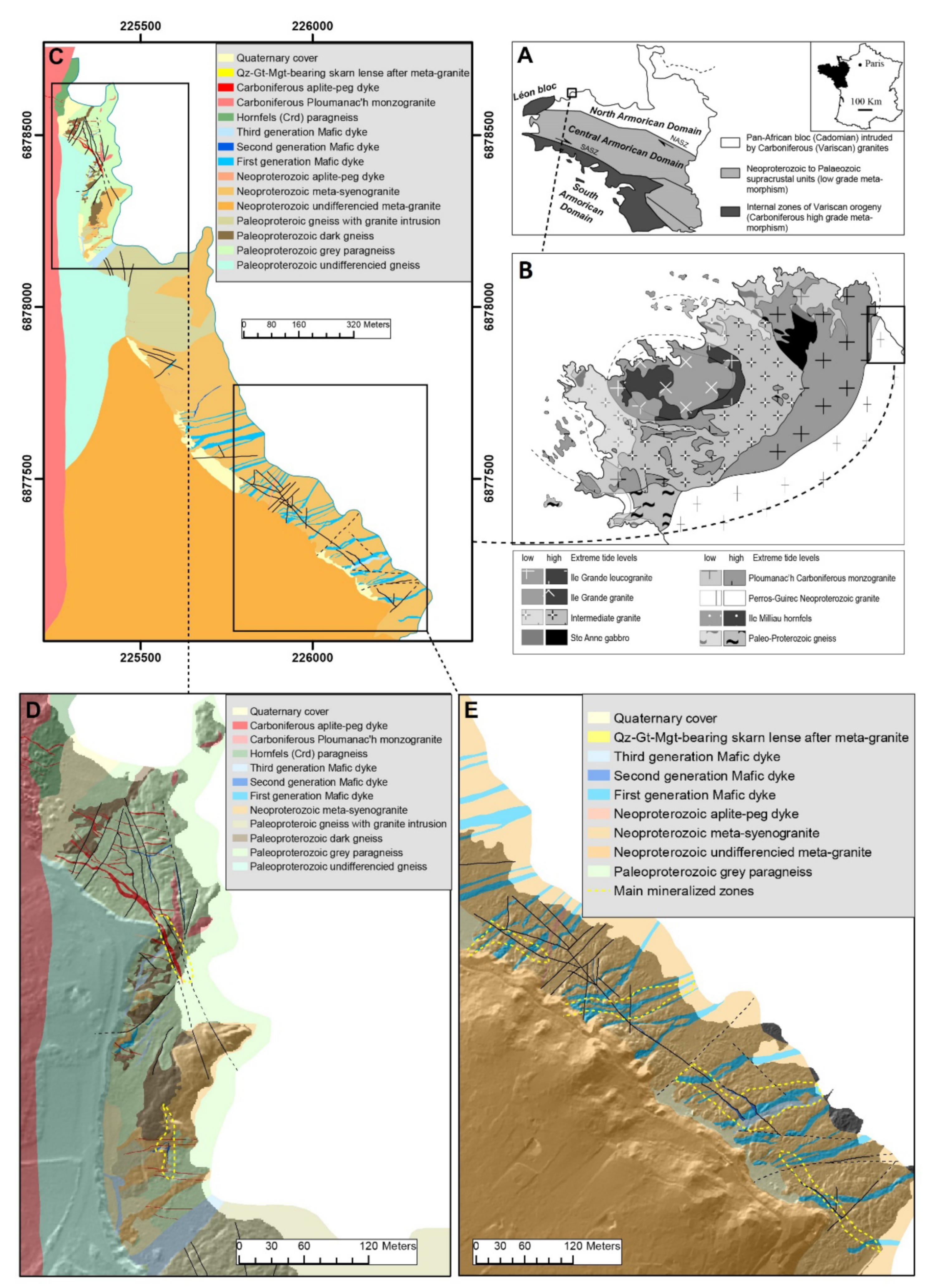
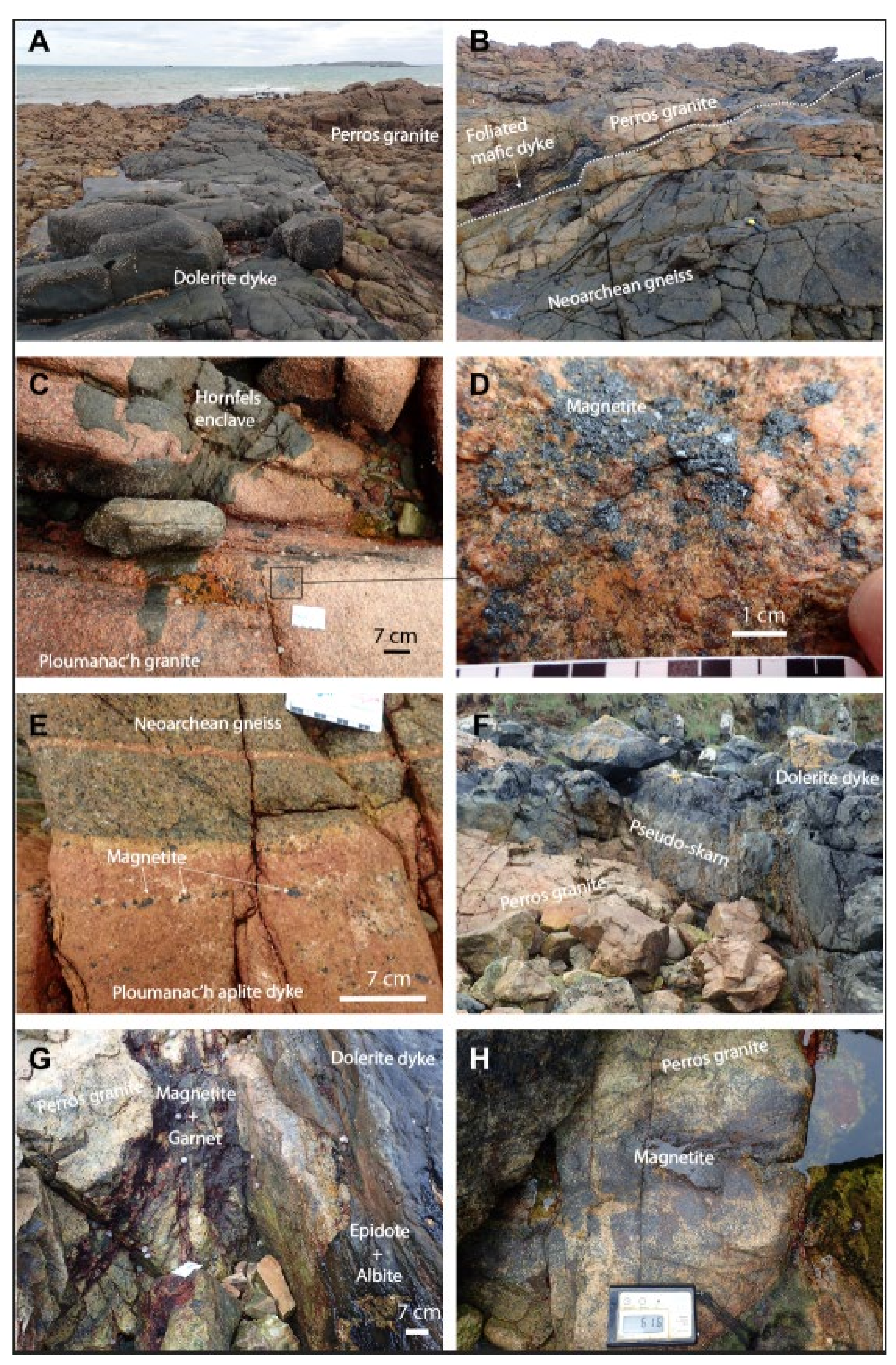
2.1. Geological Context
2.2. Data Acquisition
2.2.1. Multispectral UAV Data
2.2.2. Airborne Magnetic Data (Fixed Wing and UAV)
2.2.3. Petrophysics
3. Results
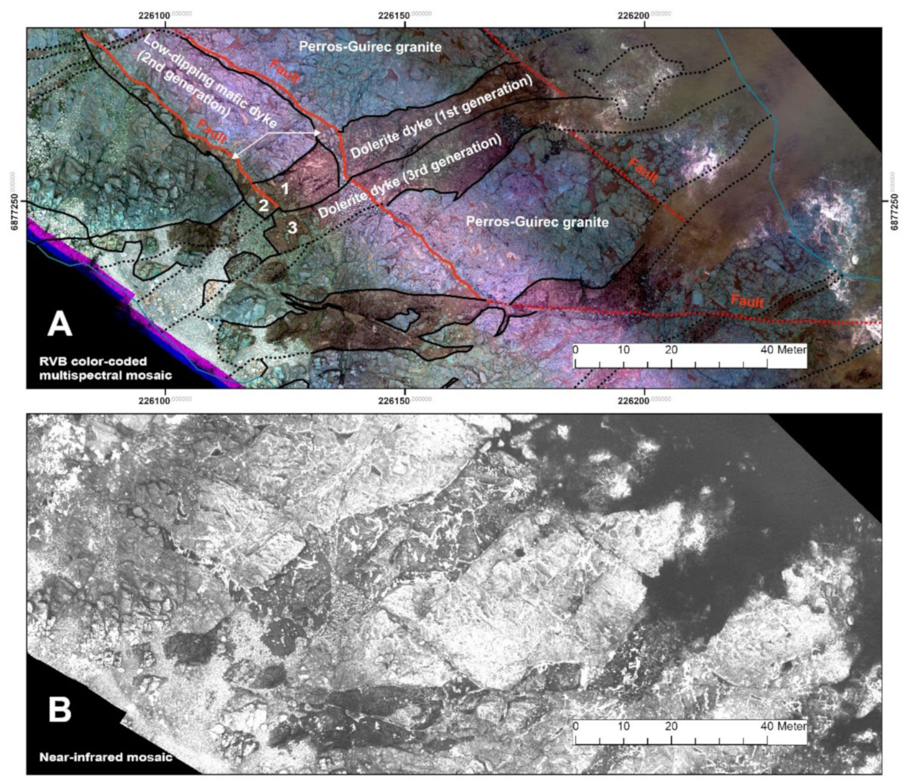
3.1. Field-UAV Detailed Geological Mapping
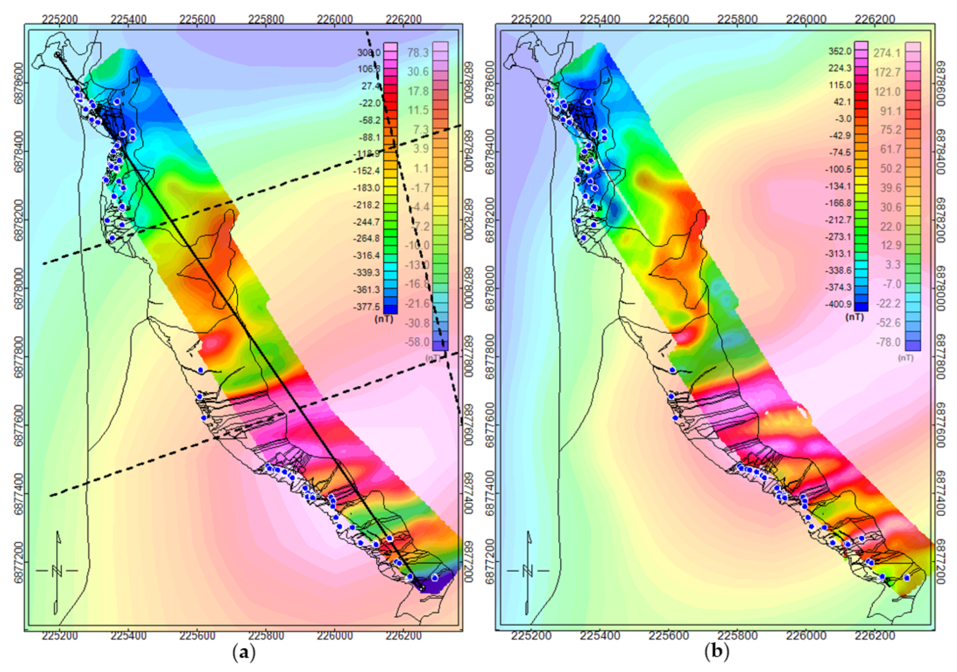
3.2. Magnetic Modelling
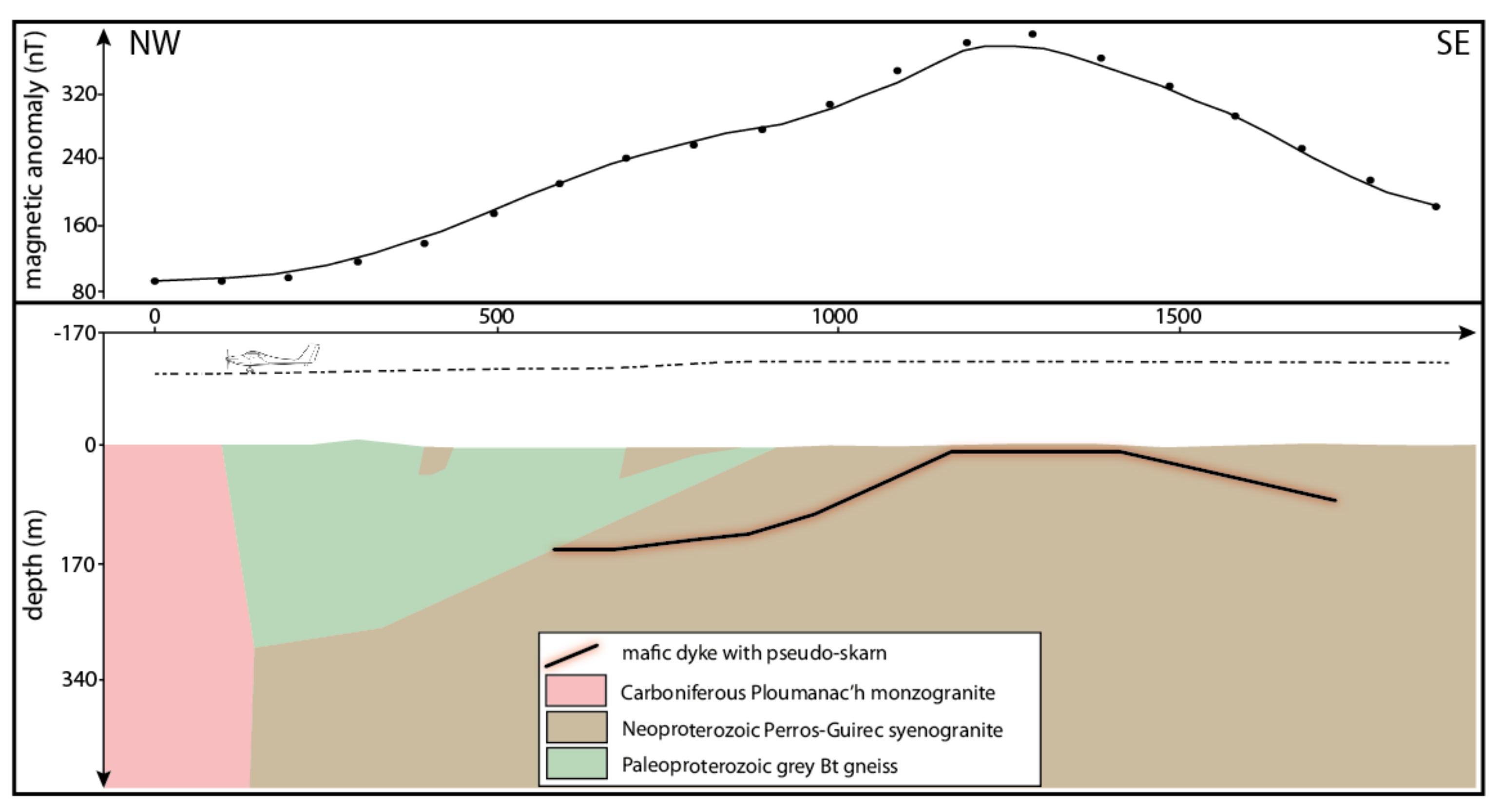
3.2.1. Regional Magnetic Modelling
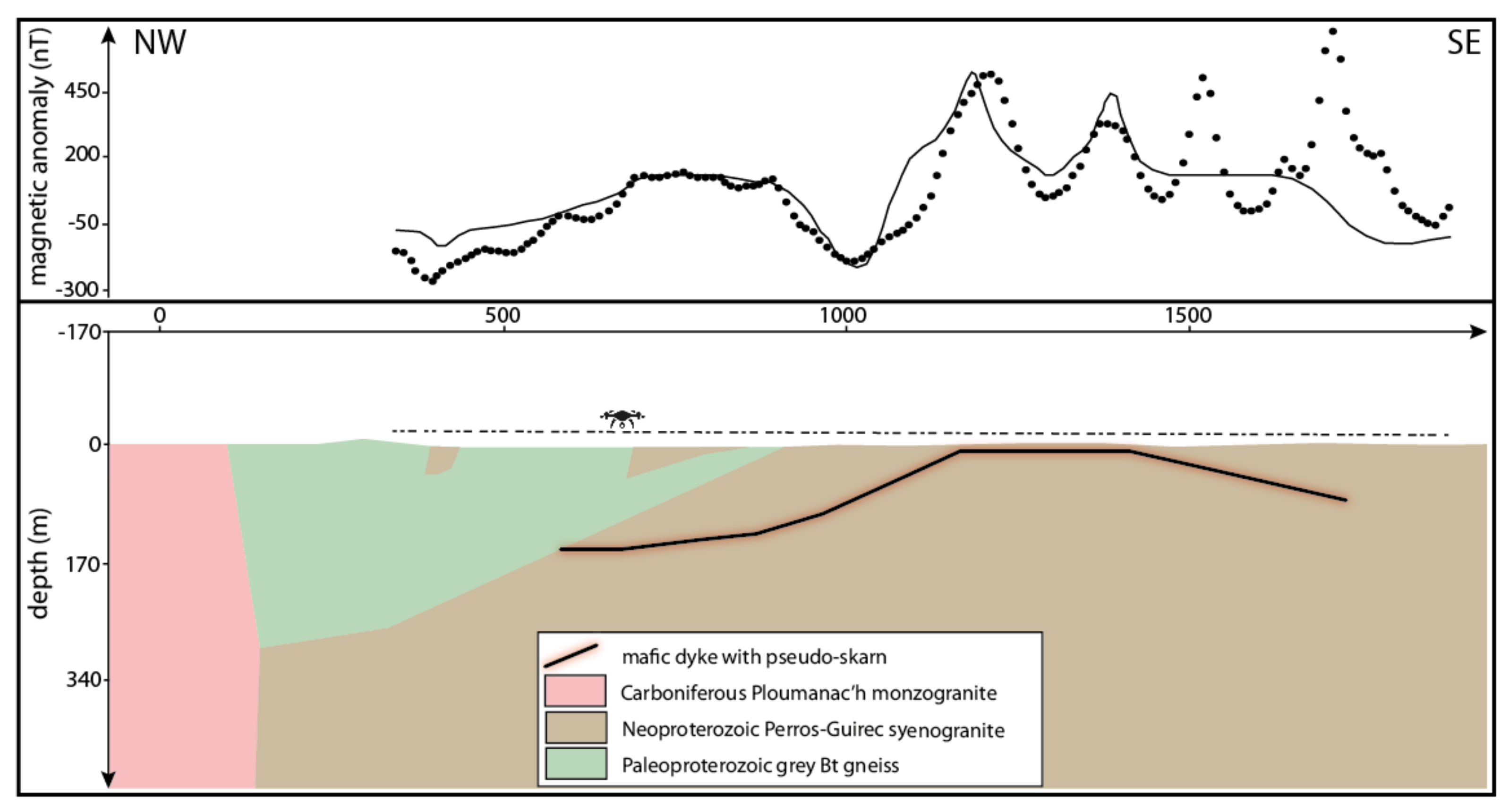
3.2.2. From Regional to Local Magnetic Modeling
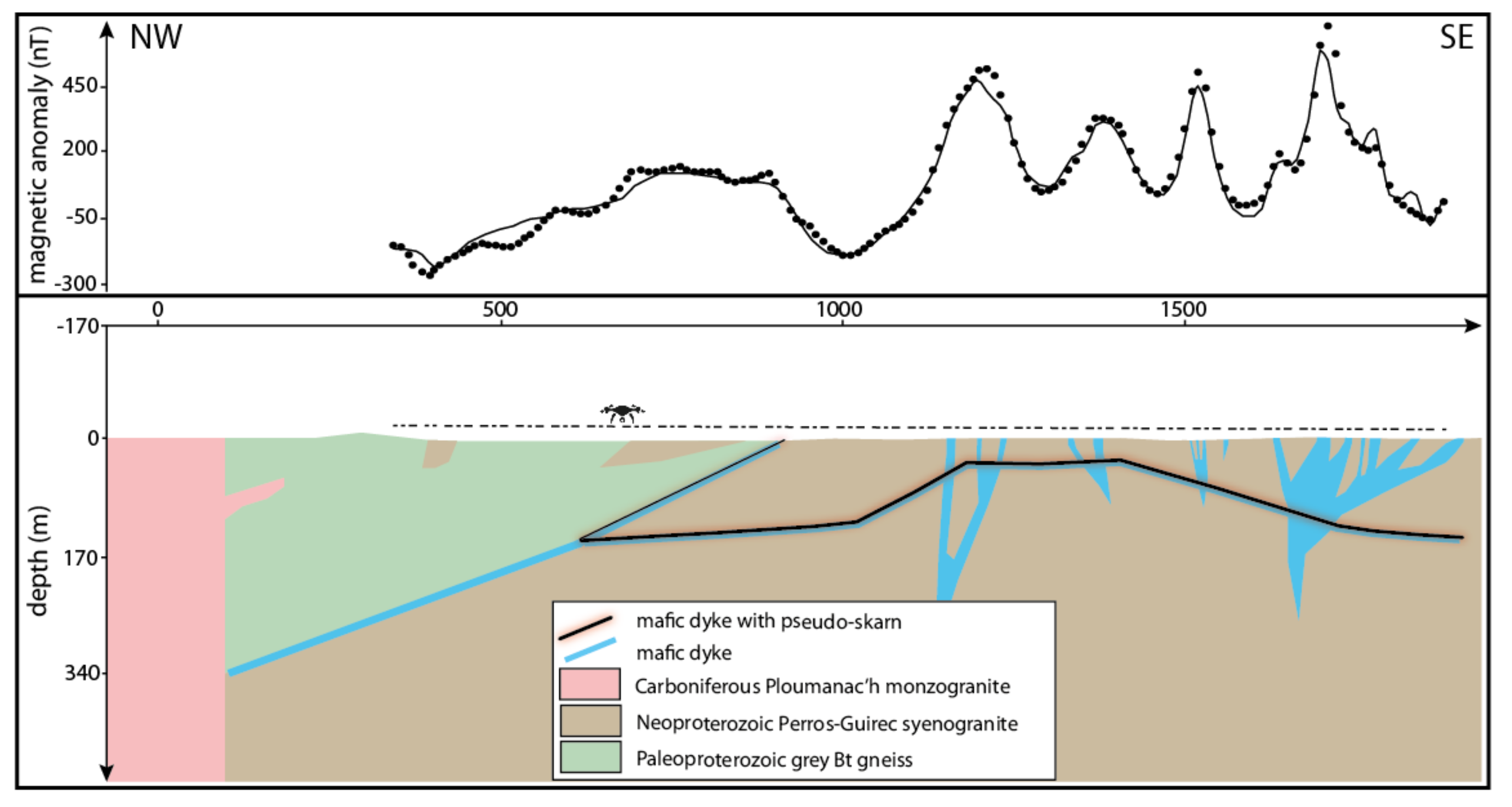
3.2.3. Local Model Refinement: Geophysically Driven
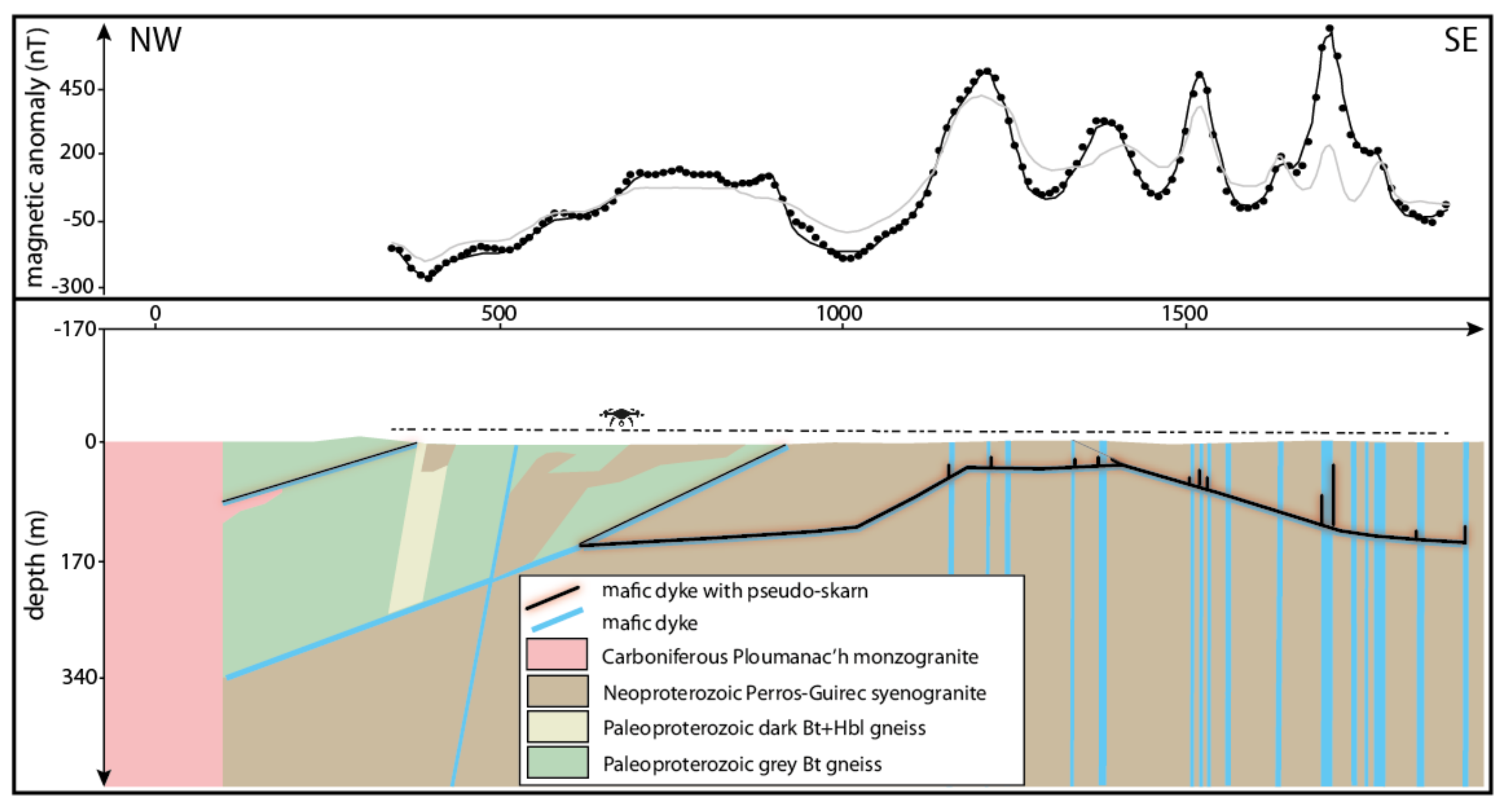
3.2.4. Final Geologically Constrained Model
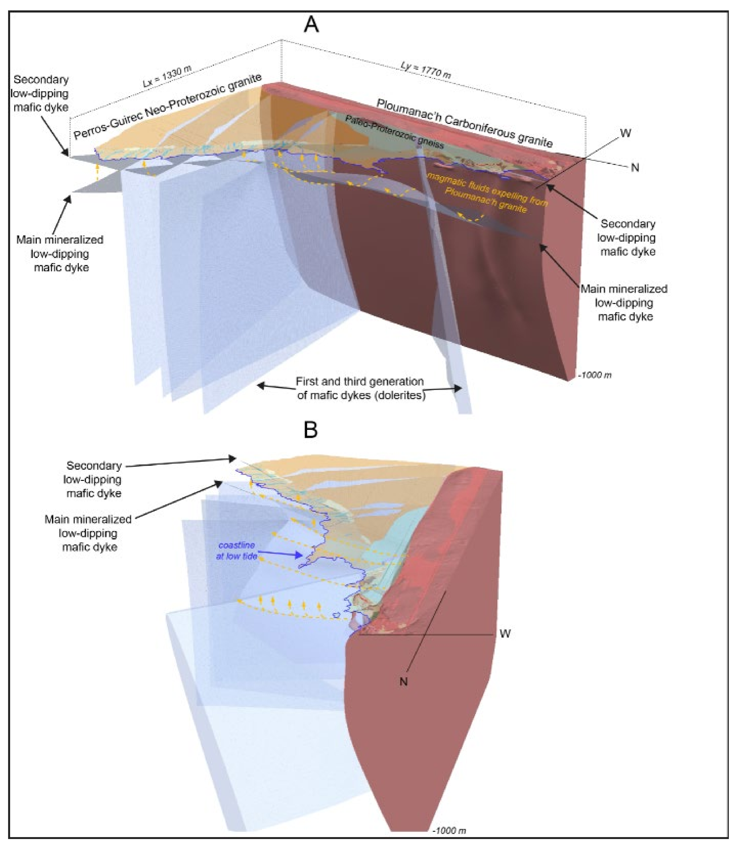
3.3. 3D Geological Modelling
4. Discussion
5. Conclusions
Author Contributions
Funding
Data Availability Statement
Acknowledgments
Conflicts of Interest
References
- Aleshin, I.M.; Ivanov, S.D.; Koryagin, V.N.; Matveev, M.A.; Morozov, Y.A.; Perederin, F.V.; Kholodkov, K.I. Review on the use of light unmanned aerial vehicles in geological and geophysical research. Seism. Instrum. 2020, 56, 509–515. [Google Scholar] [CrossRef]
- Heincke, B.; Jackisch, R.; Saartenoja, A.; Salmirinne, H.; Rapp, S.; Zimmermann, R.; Pirttijärvi, M.; Sörensen, E.V.; Gloaguen, R.; Ek, L.; et al. Developing multi-sensor drones for geological mapping and mineral exploration: Setup and first results from the MULSEDRO project. GEUS Bull. 2019, 43. [Google Scholar] [CrossRef] [Green Version]
- Kim, B. Aeromagnetic exploration using unmanned aerial vehicles: Current and future trends. Geophys. Geophys. Explor. 2020, 23, 178–191. [Google Scholar]
- Parshin, A.; Bashkeev, A.; Davidenko, Y.; Persova, M.; Iakovlev, S.; Bukhalov, S.; Grebenkin, N.; Tokareva, M. Lightweight unmanned aerial system for time-domain electromagnetic prospecting—the next stage in applied UAV-Geophysics. Appl. Sci. 2021, 11, 2060. [Google Scholar] [CrossRef]
- Middlemiss, R.P. A Practical MEMS Gravimeter. Ph.D. Thesis, University of Glasgow, Glasgow, UK, 2016. [Google Scholar]
- Limburg, H.; van der Veeke, S.; Koomans, R. Towards drone-borne gammaray mapping of soils. First Break 2019, 37, 55–61. [Google Scholar] [CrossRef]
- Jansen, J.; Bell, R. Drone Based Geophysical Surveys for Groundwater Applications; Groundwater Week; US National Ground Water Association: Westerville, OH, USA, 2019. [Google Scholar]
- Valentine, S. Geophysical trespass, privacy, and drones in oil and gas exploration. J. Air Law Commer. 2019, 84, 507. [Google Scholar]
- Colorado, J.; Perez, M.; Mondragon, I.; Mendez, D.; Parra, C.; Devia, C.; Martinez-Moritz, J.; Neira, L. An integrated aerial system for landmine detection: SDR-based Ground Penetrating Radar onboard an autonomous drone. Adv. Robot. 2017, 31, 791–808. [Google Scholar] [CrossRef]
- Park, S.; Choi, Y. Applications of unmanned aerial vehicles in mining from exploration to reclamation: A review. Minerals 2020, 10, 663. [Google Scholar] [CrossRef]
- Le Maire, P.; Bertrand, L.; Munschy, M.; Diraison, M.; Géraud, Y. Aerial magnetic mapping with an unmanned aerial vehicle and a fluxgate magnetometer: A new method for rapid mapping and upscaling from the field to regional scale. Geophys. Prosp. 2020, 68, 2307–2319. [Google Scholar] [CrossRef]
- Chauris, L. Un pseudo-skarn fissural à molybdénite et scheelite: Kerdu en Perros-Guirec (Massif armoricain). Bull. Soc. Sci. Nat. Ouest Fr. 1991, 13, 41–50. [Google Scholar]
- Egal, E.; Guerrot, C.; Thiéblemont, D.; Chantraine, J. The Cadomian Orogeny revisited in northern Britanny (France). In Avalonian and Related Peri-Gwondanan Terraces of the Circum-North Atlantic; Nance, R.-D., Thompson, M.-D., Eds.; The Geological Society: London, UK, 1996; Volume 304, pp. 281–318. [Google Scholar]
- Graviou, P. Pétrogenèse des Magmas Calco-Alcalins: Exemple des Granitoïdes Cadomiens de la Région Trégorroise (Massif Armoricain). Ph.D. Thesis, Université de Rennes, Rennes, France, 1984; 236p. [Google Scholar]
- Thiéblemont, D.; Egal, E.; Chantraine, J. Révision du volcanisme cadomien dans l’Est du Trégor (Bretagne nord). Géol. Fr. 1996, 4, 3–21. [Google Scholar]
- Auvray, B. Genèse et Evolution de la Croûte Continentale dans le Nord du Massif armoricain. Ph.D. Thesis, Rennes University, Rennes, France, 1979; 680p. [Google Scholar]
- Barboni, M.; Schoene, B.; Ovtcharova, M.; Bussy, F.; Schaltegger, U.; Gerdes, A. Timing of incremental pluton construction and magmatic activity in a back-arc setting revealed by ID-TIMS U/Pb and Hf isotopes on complex zircon grains. Chem. Geol. 2013, 342, 76–93. [Google Scholar] [CrossRef]
- Pochon, A.; Poujol, M.; Gloaguen, E.; Branquet, Y.; Cagnard, F.; Gumiaux, C.; Gapais, D. U-Pb LA-ICP-MS dating of apatite in mafic rocks: Evidence for a major magmatic event at the Devonian-Carboniferous boundary in the Armorican Massif (France). Am. Miner. 2016, 101, 2430–2442. [Google Scholar] [CrossRef]
- Albarède, F.; Dupuis, C.; Taylor, H.-P., Jr. 18O/16O evidence for non-cogenetic magmas associated in a 300 Ma old concentric pluton at Ploumanac’h. J. Geol. Soc. 1980, 137, 641–647. [Google Scholar] [CrossRef]
- Guennoc, P.; Feybesse, J.-L.; Hallégouët, B.; Lebret, P.; Chauris, L.; Lucassou, F.; Thiéblemont, D.; Choulet, F.; Eglinger, A.; Bourdillon, C.; et al. Explanatory Note of the Geological Map of France 1:50,000 Scale, Perros Guirec Sheet (170); BRGM: Orléans, France, 2015; 264p.
- Barrière, M. Le complexe de Ploumanac’h (Massif armoricain). Essai sur la Mise en Place et L’évolution Petrologique d’une Association Plutonique Sub-Alcaline Tardi-Orogénique. Ph.D. Thesis, UBO University, Brest, France, 1977; 291p. [Google Scholar]
- Vigneresse, J.L.; Cuney, M.; Jolivet, J.; Bienfait, G. Selective heat-producing element enrichment in a crustal segment of the mid-European Variscan chain. Tectonophysics 1989, 159, 47–60. [Google Scholar] [CrossRef]
- Chauris, L. Concentrations en terres rares et thorium dans les ségrégations biotitiques du granite rouge de Ploumanac’h (Massif armoricain). Géol. Fr. 1992, 2, 23–27. [Google Scholar]
- Decitre, S.; Gasquet, D.; Marignac, C. Genesis of orbicular granitic rocks from the Ploumanac’h plutonic complex (Brittany, France): Petrolographical, mineralogical and geochemical constraints. Eur. J. Miner. 2002, 14, 715–731. [Google Scholar] [CrossRef]
- Bonijoly, D.; Perrin, J.; Truffert, C.; Asfirane, F. Couverture Géophysique Aéroportée du Massif armoricain, Magnétisme et Radiométrie Spectrale; Rapport BRGM R 40471; BRGM: Paris, France, 1999; 75p.
- Døssing, A.; Silva, E.L.S.D.; Martelet, G.; Rasmussen, T.M.; Gloaguen, E.; Petersen, J.T.; Linde, J. A high-speed, light-weight scalar magnetometer bird for km scale UAV magnetic surveying: On sensor choice, bird design, and quality of output data. Remote Sens. 2021, 13, 649. [Google Scholar] [CrossRef]
- Grant, F.S.; West, G.F. Interpretation Theory in Applied Geophysics; McGraw-Hill Book: New York, NY, USA, 1965. [Google Scholar]
- Oehler, J.F.; Lequentrec-Lalancette, M.F. The contribution of marine magnetics in the Gulf of Saint-Malo (Brittany, France) to the understanding of the geology of the North Armorican Cadomian belt. C. R. Geosci. 2019, 351, 1–9. [Google Scholar] [CrossRef]
- Calcagno, P.; Chilès, J.P.; Courrioux, G.; Guillen, A. Geological modelling from field data and geological knowledge: Part, I. Modelling method coupling 3D potential-field interpolation and geological rules. Phys. Earth Planet. Inter. 2008, 171, 147–157. [Google Scholar] [CrossRef]


| Aver. | Std. | # Sites | Code | Lithology |
|---|---|---|---|---|
| 7.6 | 8.7 | 23 | GPGN | Paleoproterozoic Bt-bearing grey paragneiss. |
| 6.1 | 4.8 | 5 | PMGT | Carboniferous Ploumanac’h monzogranite |
| 7.1 | 4.6 | 6 | PAPD | Carboniferous aplite-pegmatite dyke. |
| 7.6 | 5.4 | 8 | DPGN | Paleoproterozoic. Dark Bt+-Hbl-bearing gneiss |
| 13.2 | 5.4 | 20 | NSGT | Perros-Guirec Neoproterozoic meta-syenogranite. |
| 32.8 | 39.6 | 22 | DOL | Dolerite dyke |
| 301.2 | 288.2 | 13 | SK | Pseudoskarn accompanying dolerites, granites and gneisses |
| 25.7 | 20.2 | 5 | DOLA | 1st gen. of mafic dykes including numerous fine grained mafic enclaves |
| 0.4 | 0.3 | 6 | DOLF | 2nd gen. of mafic dyke. Strongly foliated mafic dyke. |
Publisher’s Note: MDPI stays neutral with regard to jurisdictional claims in published maps and institutional affiliations. |
© 2021 by the authors. Licensee MDPI, Basel, Switzerland. This article is an open access article distributed under the terms and conditions of the Creative Commons Attribution (CC BY) license (https://creativecommons.org/licenses/by/4.0/).
Share and Cite
Martelet, G.; Gloaguen, E.; Døssing, A.; Lima Simoes da Silva, E.; Linde, J.; Rasmussen, T.M. Airborne/UAV Multisensor Surveys Enhance the Geological Mapping and 3D Model of a Pseudo-Skarn Deposit in Ploumanac’h, French Brittany. Minerals 2021, 11, 1259. https://doi.org/10.3390/min11111259
Martelet G, Gloaguen E, Døssing A, Lima Simoes da Silva E, Linde J, Rasmussen TM. Airborne/UAV Multisensor Surveys Enhance the Geological Mapping and 3D Model of a Pseudo-Skarn Deposit in Ploumanac’h, French Brittany. Minerals. 2021; 11(11):1259. https://doi.org/10.3390/min11111259
Chicago/Turabian StyleMartelet, Guillaume, Eric Gloaguen, Arne Døssing, Eduardo Lima Simoes da Silva, Johannes Linde, and Thorkild M. Rasmussen. 2021. "Airborne/UAV Multisensor Surveys Enhance the Geological Mapping and 3D Model of a Pseudo-Skarn Deposit in Ploumanac’h, French Brittany" Minerals 11, no. 11: 1259. https://doi.org/10.3390/min11111259
APA StyleMartelet, G., Gloaguen, E., Døssing, A., Lima Simoes da Silva, E., Linde, J., & Rasmussen, T. M. (2021). Airborne/UAV Multisensor Surveys Enhance the Geological Mapping and 3D Model of a Pseudo-Skarn Deposit in Ploumanac’h, French Brittany. Minerals, 11(11), 1259. https://doi.org/10.3390/min11111259