Assessment of Water Quality and Soil Salinity in the Agricultural Coastal Plain (Ravenna, North Italy)

 , , and
Abstract
1. Introduction
2. Materials and Methods
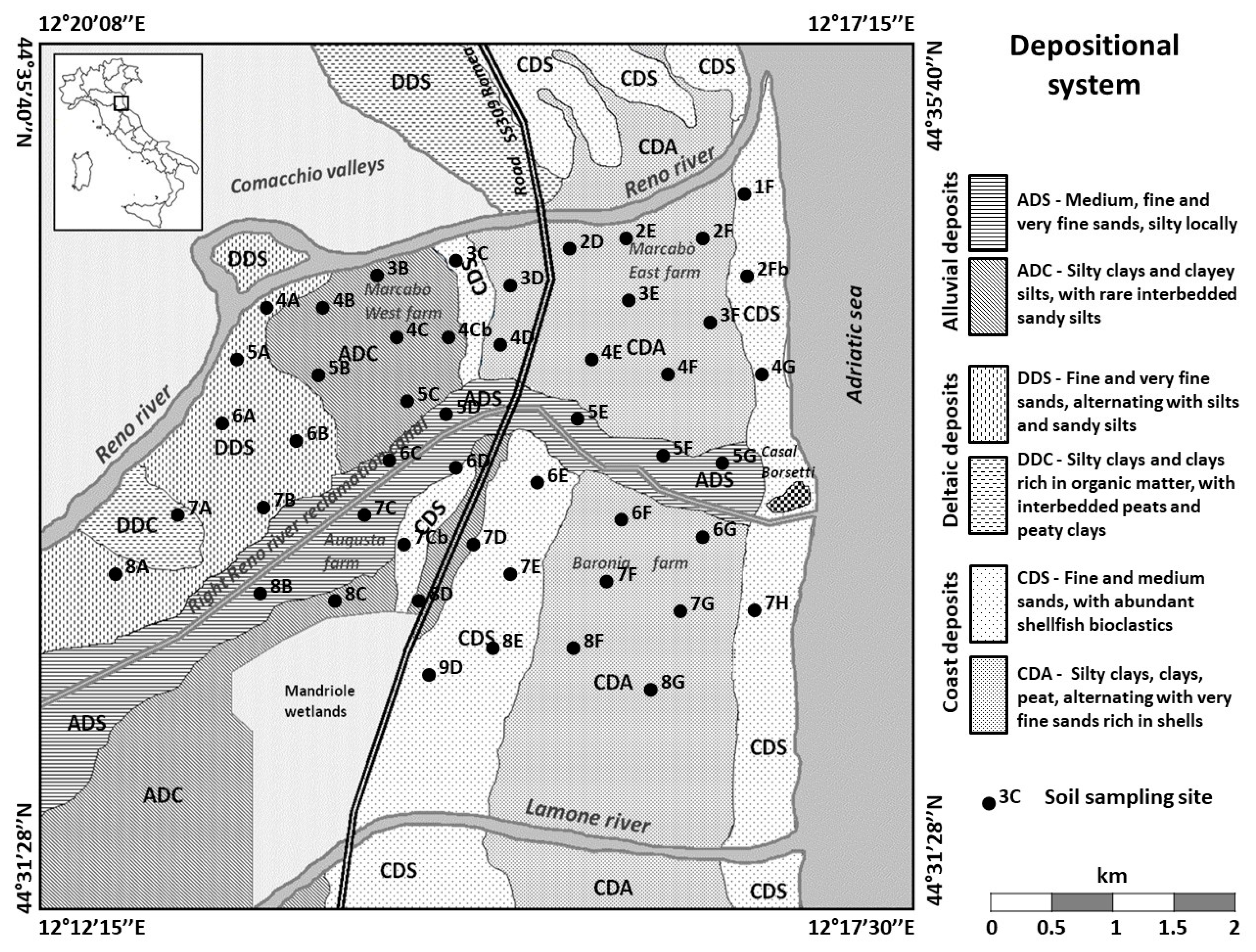
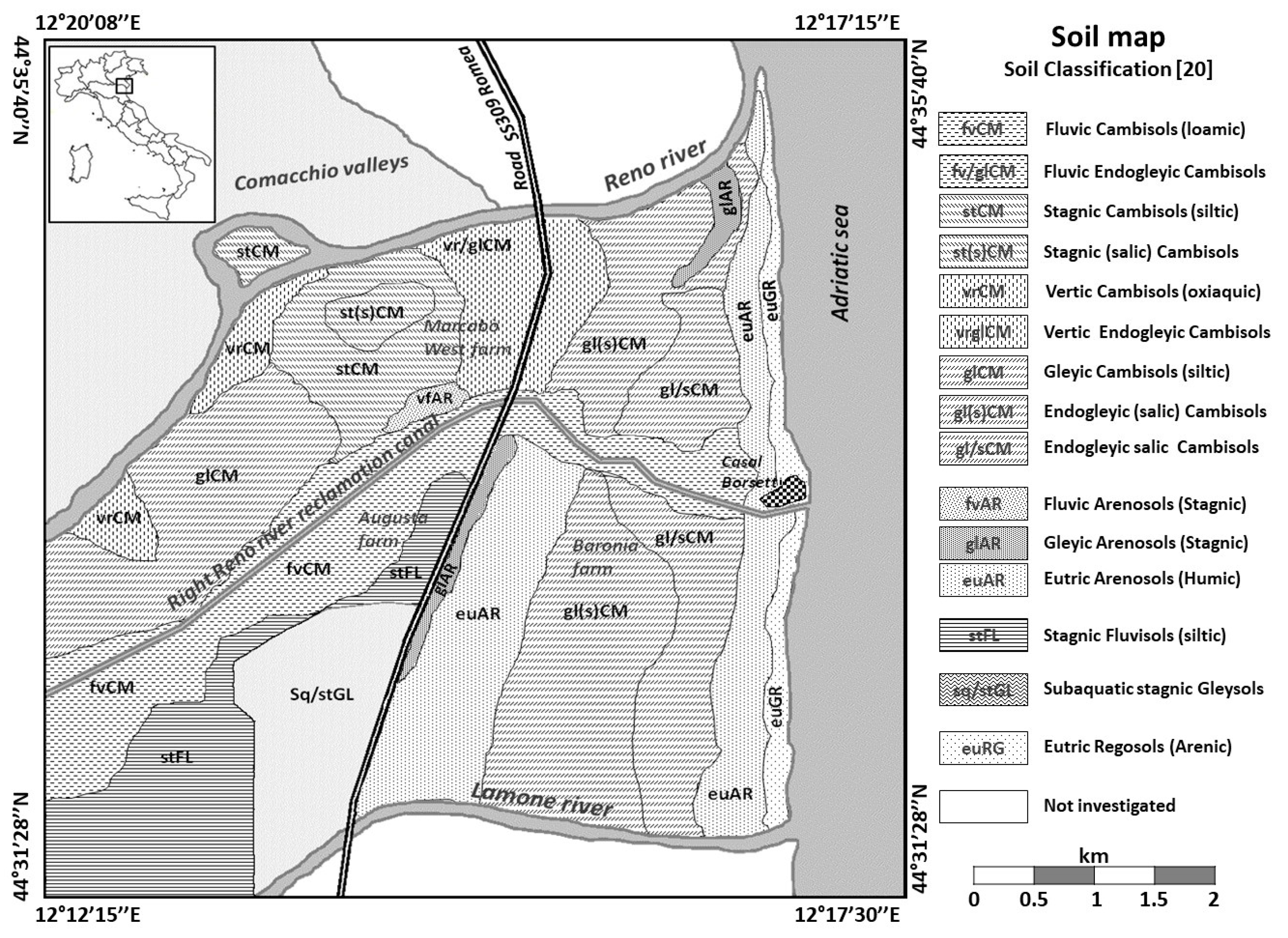
2.1. Study Area
2.2. Soil Sampling
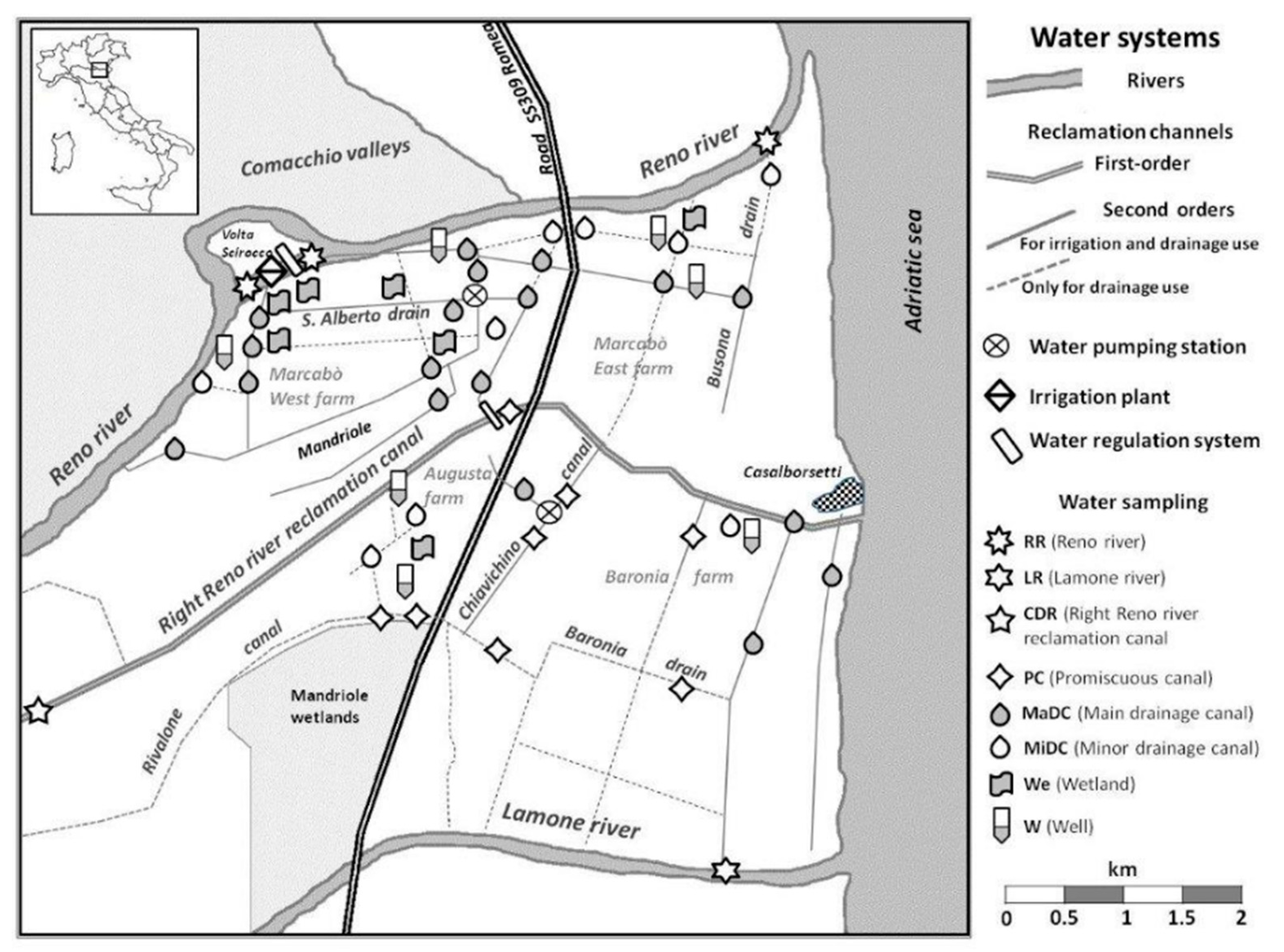
2.3. Water Sampling
2.4. Soil Analyses
2.5. Water Analyses
2.6. Data Processing
3. Results
3.1. Soil Quality in the Agricultural Coastal Plain
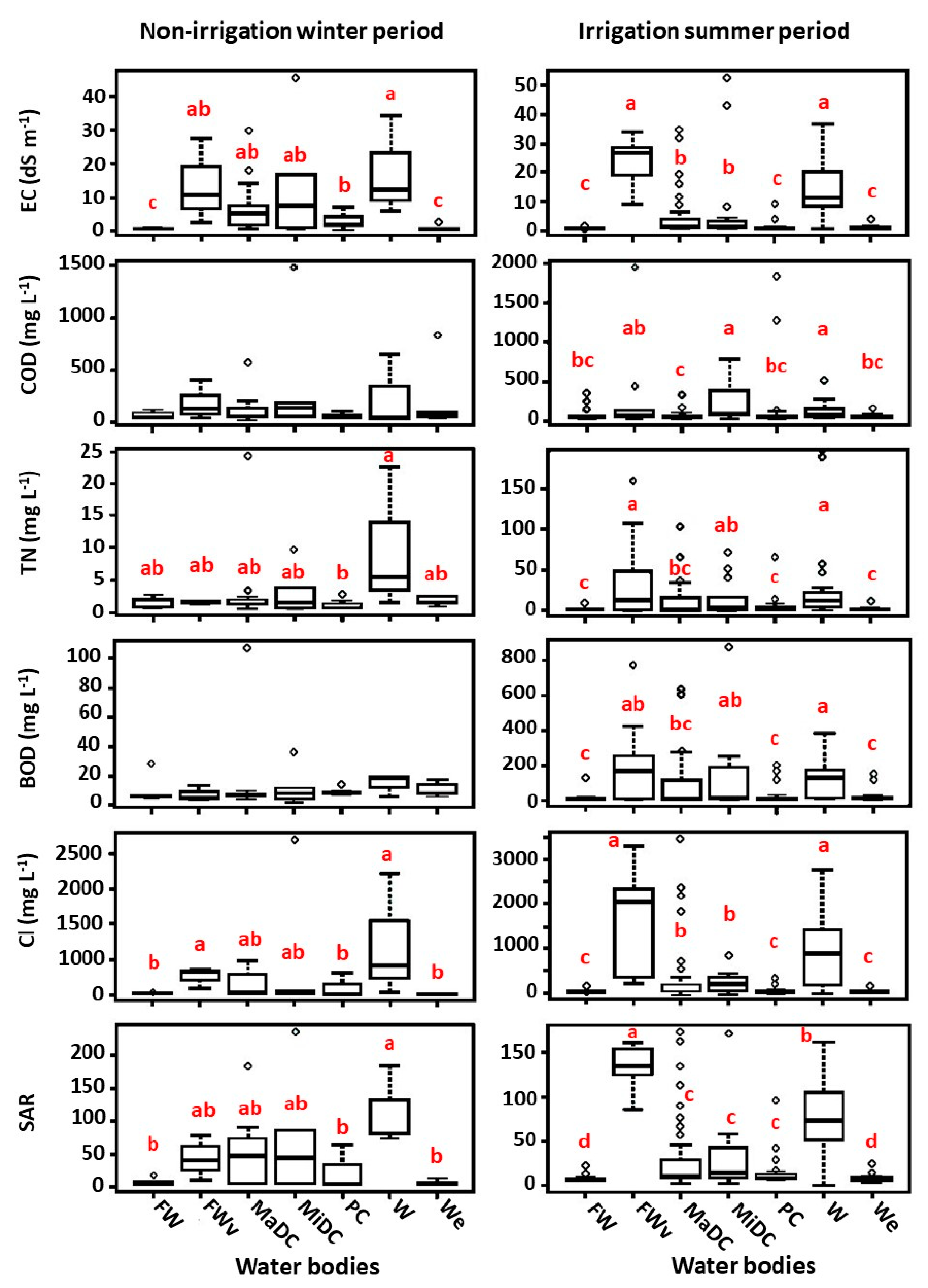
3.2. Water Quality of Canals Network and Water Bodies in Agricultural Coastal Plain
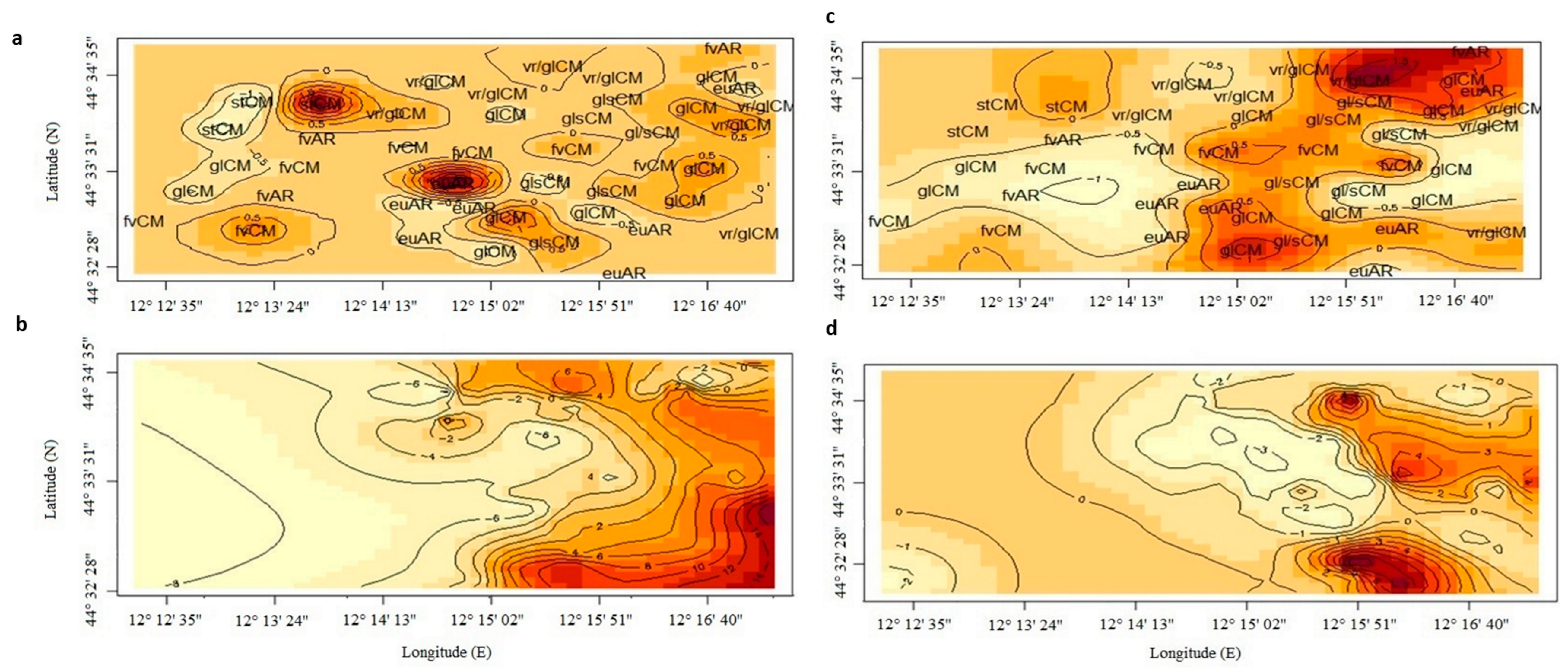
3.3. Spatial Distribution of Soil and Water Salinity in the Agricultural Coastal Plain
4. Discussion
4.1. Organic C Concentration and Seasonal Evolution of Soil Salinity
4.2. Seasonal Evolution of Water Quality
4.3. Risk of Soil Degradation Due to Soil Type–Irrigation Water Interaction
5. Conclusions
Supplementary Materials
Author Contributions
Funding
Conflicts of Interest
References
- Daliakopoulos, I.N.; Tsanis, I.K.; Koutroulis, A.; Kourgialas, N.N.; Varouchakis, A.E.; Karatzas, G.P.; Ritsema, C.J. The threat of soil salinity: A European scale review. Sci. Total Environ. 2016, 573, 727–739. [Google Scholar] [CrossRef] [PubMed]
- FAO. Status of the World’s Soil Resources; Intergovernmental Technical Panel on Soils: Rome, Italy, 2015; pp. 123–126. [Google Scholar]
- Tóth, G.; Montanarella, L.; Rusco, E. Threats to Soil Quality in Europe; Institute for Environment and Sustainability: Ispra, Italy, 2008. [Google Scholar]
- Bauder, J.W.; Brock, T.A. Irrigation Water Quality, Soil Amendment, and Crop Effects on Sodium Leaching. Arid Land Res. Manag. 2001, 15, 101–113. [Google Scholar] [CrossRef]
- Barbarella, M.; Giglio, M.D.; Avantaggiato, A. Studio degli effetti dell’intrusione del cuneo salino sulla vegetazione costiera mediante dati satellitari. In Proceedings of the Atti 16a Conferenza Nazionale ASITA, Vicenza, Italy, 6–8 November 2012; pp. 121–128. [Google Scholar]
- Andreu, L.; Moreno, F.; Jarvis, N.J.; Vachaud, G. Application of the model MACRO to water movement and salt leaching in drained and irrigated marsh soils, Marismas, Spain. Agric. Water Manag. 1994, 25, 71–88. [Google Scholar] [CrossRef]
- Ayers, R.S.; Westcot, D.W. Water Quality for Agriculture; FAO United Nations: Rome, Italy, 1985; p. 97. [Google Scholar]
- Artiola, J.F.; Walworth, J.L. Irrigation water quality effects on soil carbon fractionation and organic carbon dissolution and leaching in a semiarid calcareous soil. Soil Sci. 2009, 174, 365–371. [Google Scholar] [CrossRef]
- Minhas, P.S.; Ramos, T.B.; Ben-Gal, A.; Pereira, L.S. Coping with salinity in irrigated agriculture: Crop evapotranspiration and water management issues. Agric. Water Manag. 2020, 227, 105832. [Google Scholar] [CrossRef]
- Mateo-sagasta, J. Agriculture and Water Quality Interactions: A Global Overview; FAO: Rome, Italy, 2010; Volume 8, pp. 25–34. [Google Scholar]
- Panagea, I.S.; Daliakopoulos, I.N.; Tsanis, I.K.; Schwilch, G. Evaluation of promising technologies for soil salinity amelioration in Timpaki (Crete): A participatory approach. Solid Earth 2016, 7, 177–190. [Google Scholar] [CrossRef]
- Buscaroli, A.; Zannoni, D. Influence of ground water on soil salinity in the San Vitale Pinewood (Ravenna—Italy). Agrochimica 2010, 5, 303–320. [Google Scholar]
- Teatini, P.; Ferronato, M.; Gambolati, G.; Bertoni, W.; Gonella, M. A century of land subsidence in Ravenna, Italy. Environ. Geol. 2005, 47, 831–846. [Google Scholar] [CrossRef]
- Petrini, R.; Pennisi, M.; Vittori Antisari, L.; Cidu, R.; Vianello, G.; Aviani, U. Geochemistry and stable isotope composition of surface waters from the Ravenna plain (Italy): Implications for the management of water resources in agricultural lands. Environ. Earth Sci. 2014, 71, 5099–5111. [Google Scholar] [CrossRef]
- RER Carta dei suoli dell’Emilia Romagna. Available online: https://ambiente.regione.emilia-romagna.it/it/geologia/suoli (accessed on 19 May 2017).
- Antonellini, M.; Mollema, P.N.; Capo, D.; Greggio, N.; Allen, D.M. Groundwater freshening following coastal progradation and land reclamation of the Po Plain, Italy. Hydrogeol. J. 2015, 23, 1009–1026. [Google Scholar] [CrossRef]
- Western Romagna Land Reclamation Consortium. Available online: https://www.romagnaoccidentale.it/# (accessed on 11 April 2020).
- Zucaro, R.; Furlani, A. Rapporto sullo stato dell’irrigazione in Emilia-Romagna; INEA: Rome, Italy, 2009. [Google Scholar]
- ISPRA CARG Project—Geological and Geothematic Cartography. Available online: www.isprambiente.gov.it/en/projects/soil-and-territory/carg-project-geologic-and-geothematic-cartography (accessed on 19 May 2017).
- FAO. World Reference Base for Soil Resources 2014: International Soil Classification System for Naming Soils and Creating Legends for Soil Maps; FAO: Rome, Italy, 2014. [Google Scholar]
- Cipolla, S.S.; Maglionico, M.; Serra, F.; Venturi, M. Modellazione Numerica Per La Gestione Dei Canali Di Bonifica Del Comparto Idraulico Savarna- Sant’ Alberto-Mandriole (Ravenna). In Proceedings of the Atti del XXXVI Convegno Nazionale di Idraulica e Costruzioni Idrauliche, Ancona, Italy, 12–14 September 2018; pp. 12–14. [Google Scholar]
- Cipolla, S.S.; Maglionico, M.; Masina, M.; Lamberti, A.; Daprà, I. Real time monitoring of water quality in an agricultural area with salinity problems. Environ. Eng. Manag. J. 2019, 18, 2229–2240. [Google Scholar]
- Wibawa, W.D.; Dludlu, D.L.; Swenson, L.J.; Hopkins, D.G.; Dahnke, W.C. Variable Fertilizer Application Based on Yield Goal, Soil Fertility, and Soil Map Unit. JPA 1993, 6, 255. [Google Scholar] [CrossRef]
- ARPAE Osservatorio Clima Emilia-Romagna, Agenzia Prevenzione Ambiente Energia Emilia Romagna. Available online: https://www.arpae.it/dettaglio_generale.asp?id=2867&idlivello=1591 (accessed on 9 April 2020).
- Pan, W.; Boyles, R.P.; White, J.G.; Heitman, J.L. Characterizing soil physical properties for soil moisture monitoring with the North Carolina environment and climate observing network. J. Atmos. Ocean. Technol. 2012, 29, 933–943. [Google Scholar] [CrossRef]
- Klute, A. Water Retention: Laboratory Methods. In Methods of Soil Analysis: Part 1—Physical and Mineralogical Methods; SSSA Book Series: Madison, WI, USA, 1986. [Google Scholar]
- Schulte, E.E.; Hopkins, B.G. Estimation of organic matter by weight loss-on-ignition. Soil Org. Matter Anal. Interpret. 1996, 46, 21–31. [Google Scholar]
- Cambardella, C.A.; Gajda, A.M.; Doran, J.W.; Wienhold, B.J.; Kettler, T.A. Estimation of particulate and total organic matter by weight loss-on-ignition. In Assessment Methods for Soil Carbon (Advances in Soil Science); CRC Press: Boca Raton, FL, USA, 2001; pp. 349–359. [Google Scholar]
- Howard, P.J.A.; Howard, D.M. Use of organic carbon and loss-on-ignition to estimate soil organic matter in different soil types and horizons. Biol. Fertil. Soils 1990, 9, 306–310. [Google Scholar] [CrossRef]
- Abella, S.R.; Zimmer, B.W. Estimating Organic Carbon from Loss-On-Ignition in Northern Arizona Forest Soils. Soil Sci. Soc. Am. J. 2007, 71, 545. [Google Scholar] [CrossRef]
- De Vos, B.; Vandecasteele, B.; Deckers, J.; Muys, B. Capability of loss-on-ignition as a predictor of total organic carbon in non-calcareous forest soils. Commun. Soil Sci. Plant Anal. 2005, 36, 2899–2921. [Google Scholar] [CrossRef]
- Loeppert, R.H.; Suarez, D.L. Carbonate and Gypsun; USDA-ARS/UNL Faculty: Lincoln, CA, USA, 1996. [Google Scholar]
- Gee, G.W.; Bauder, J.W. Methods of Soil Analysis: Part 1—Physical and Mineralogical Methods; SSSA Book Series; Soil Science Society of America, American Society of Agronomy: Madison, WI, USA, 1986. [Google Scholar]
- R Core Team. R: A Language and Environment for Statistical Computing; R Foundation for Statistical Computing: Vienna, Austria, 2014. [Google Scholar]
- Setia, R.; Gottschalk, P.; Smith, P.; Marschner, P.; Baldock, J.; Setia, D.; Smith, J. Soil salinity decreases global soil organic carbon stocks. Sci. Total Environ. 2013, 465, 267–272. [Google Scholar] [CrossRef]
- Nabiollahi, K.; Taghizadeh-Mehrjardi, R.; Kerry, R.; Moradian, S. Assessment of soil quality indices for salt-affected agricultural land in Kurdistan Province, Iran. Ecol. Indic. 2017, 83, 482–494. [Google Scholar] [CrossRef]
- Loveland, P.; Webb, J. Is there a critical level of organic matter in the agricultural soils of temperate regions: A review. Soil Tillage Res. 2003, 70, 1–18. [Google Scholar] [CrossRef]
- Vinther, F.P.; Hansen, E.M.; Eriksen, J. Leaching of soil organic carbon and nitrogen in sandy soils after cultivating grass-clover swards. Biol. Fertil. Soils 2006, 43, 12–19. [Google Scholar] [CrossRef]
- Swanston, C.W.; Torn, M.S.; Hanson, P.J.; Southon, J.R.; Garten, C.T.; Hanlon, E.M.; Ganio, L. Initial characterization of processes of soil carbon stabilization using forest stand-level radiocarbon enrichment. Geoderma 2005, 128, 52–62. [Google Scholar] [CrossRef]
- Lutzow, M.V.; Kogel-Knabner, I.; Ekschmitt, K.; Matzner, E.; Guggenberger, G.; Marschner, B.; Flessa, H. Stabilization of organic matter in temperate soils: Mechanisms and their relevance under different soil conditions—A review. Eur. J. Soil Sci. 2006, 57, 426–445. [Google Scholar] [CrossRef]
- Don, A.; Scholten, T.; Schulze, E.-D. Conversion of cropland into grassland: Implications for soil organic-carbon stocks in two soils with different texture. J. Plant Nutr. Soil Sci. 2009, 172, 53–62. [Google Scholar] [CrossRef]
- Benbi, D.K.; Nieder, R. Handbook of Processes and Modeling in the Soil-Plant System; CRC Press: New York, NY, USA, 2003. [Google Scholar]
- Celik, I. Land-use effects on organic matter and physical properties of soil in a southern Mediterranean highland of Turkey. Soil Tillage Res. 2005, 83, 270–277. [Google Scholar] [CrossRef]
- Morrissey, E.M.; Gillespie, J.L.; Morina, J.C.; Franklin, R.B. Salinity affects microbial activity and soil organic matter content in tidal wetlands. Glob. Chang. Biol. 2014, 20, 1351–1362. [Google Scholar] [CrossRef]
- Rietl, A.J.; Overlander, M.E.; Nyman, A.J.; Jackson, C.R. Microbial Community Composition and Extracellular Enzyme Activities Associated with Juncus roemerianus and Spartina alterniflora Vegetated Sediments in Louisiana Saltmarshes. Microb. Ecol. 2016, 71, 290–303. [Google Scholar] [CrossRef]
- Shaygan, M.; Baumgartl, T.; Arnold, S.; Reading, L.P. The effect of soil physical amendments on reclamation of a saline-sodic soil: Simulation of salt leaching using HYDRUS-1D. Soil Res. 2018, 56, 829–845. [Google Scholar] [CrossRef]
- Richards, L.A. Diagnosis and Improvement of Saline and Alkali Soils; United States Department of Agriculture: Washington, DC, USA, 1954; Volume 78.
- Sparks, D.L.; Page, A.L.; Helmke, P.A.; Loeppert, R.H.; Rhoades, J.D. Salinity: Electrical Conductivity and Total Dissolved Solids. In Methods of Soil Analysis Part 3—Chemical Methods; Soil Science Society of America and American Society of Agronomy: Madison, WI, USA, 1996. [Google Scholar]
- Genua-Olmedo, A.; Alcaraz, C.; Caiola, N.; Ibáñez, C. Sea level rise impacts on rice production: The Ebro Delta as an example. Sci. Total Environ. 2016, 571, 1200–1210. [Google Scholar] [CrossRef]
- He, Y.; Lehndorff, E.; Amelung, W.; Wassmann, R.; Alberto, M.C.; von Unold, G.; Siemens, J. Drainage and leaching losses of nitrogen and dissolved organic carbon after introducing maize into a continuous paddy-rice crop rotation. Agric. Ecosyst. Environ. 2017, 249, 91–100. [Google Scholar] [CrossRef]
- Said-Pullicino, D.; Miniotti, E.F.; Sodano, M.; Bertora, C.; Lerda, C.; Chiaradia, E.A.; Romani, M.; Cesari de Maria, S.; Sacco, D.; Celi, L. Linking dissolved organic carbon cycling to organic carbon fluxes in rice paddies under different water management practices. Plant Soil 2016, 401, 273–290. [Google Scholar] [CrossRef]
- De Paul Obade, V.; Lal, R. Towards a standard technique for soil quality assessment. Geoderma 2016, 265, 96–102. [Google Scholar] [CrossRef]
- Masina, M.; Calone, R.; Barbanti, L.; Mazzotti, C.; Lamberti, A.; Speranza, M. Smart water and soil salinity management in agro-wetlands. Environ. Eng. Manag. J. 2019, 2273–2285. [Google Scholar]


| Localization/Identification | Water Body Types | Code | Water Sample Code |
|---|---|---|---|
| Reno river | River | RR | FW–freshwater samples from upstream stations |
| FWv–freshwater samples from downstream stations | |||
| Lamone river | River | LR | FW–freshwater samples from upstream stations |
| FWv–freshwater samples from downstream stations | |||
| Right Reno River canal | Reclamation canal | CDR | FW–freshwater samples from upstream stations |
| FWv–freshwater samples from downstream stations | |||
| Main drainage canal | Drainage canal | MaDC | MaDC |
| Minor drainage canal | Drainage and irrigation canal | MiDC | MiDC |
| Promiscuous canal | Drainage and irrigation canal | PC | PC |
| Wetland | Constructed wetland in the agricultural land | WE | WE |
| Well | Well at 3 m of depth | W | W |
| Superficial Layers (0–30 cm Soil Depth) | |||||||||||
| Soil classification | pH | CaCO3 | Sand | Silt | Clay | TOC | FC | BD | ECew | ECes | |
| % | g cm−3 | dS m−1 | |||||||||
| euAR | mean | 7.5 | 11.4 | 90 | 6 | 4 | 0.3 | 18 | 1.5 | 1.5 | 0.9 |
| SE | 0.1 | 1.8 | 2.9 | 1.8 | 1.6 | 0.3 | 4.0 | 0.1 | 0.4 | 0.2 | |
| fvCM | mean | 7.8 | 16.9 | 33 | 49 | 18 | 0.8 | 23 | 1.5 | 1.1 | 1.5 |
| SE | 0.1 | 4.2 | 2.5 | 2.7 | 0.6 | 0.2 | 1.9 | 0.1 | 0.1 | 0.3 | |
| glCM | mean | 7.8 | 19.6 | 20 | 59 | 21 | 0.8 | 27 | 1.5 | 1.6 | 1.2 |
| SE | 0.1 | 1 | 4.4 | 2.9 | 1.8 | 0.1 | 2.4 | 0 | 0.4 | 0.3 | |
| gl(s)CM | mean | 7.8 | 19.3 | 15 | 51 | 34 | 0.7 | 26 | 1.5 | 1.6 | 2.5 |
| SE | 0.1 | 1 | 3.2 | 4.7 | 4.7 | 0.1 | 2.0 | 0.1 | 0.2 | 0.3 | |
| stCM | mean | 7.8 | 20.8 | 7 | 49 | 44 | 1.1 | 29 | 1.9 | 1.7 | 2.1 |
| SE | 0.1 | 1.8 | 0.8 | 4.2 | 3.7 | 0.2 | 1.7 | 0 | 0.4 | 0 | |
| vr/glCM | mean | 7.9 | 17.1 | 14 | 48 | 38 | 1.1 | 23 | 1.7 | 1.2 | 1.6 |
| SE | 0.0 | 1.1 | 2.7 | 2.2 | 1.9 | 0.1 | 1.6 | 0.1 | 0.2 | 0.1 | |
| Depth Layers (30–90 cm Soil Depth) | |||||||||||
| Soil classification | pH | CaCO3 | Sand | Silt | Clay | TOC | FC | BD | ECew | ECes | |
| % | g cm−3 | dS m−1 | |||||||||
| euAR | mean | 7.5 | 11.4 | 90 | 6 | 4 | 0.3 | 18 | 1.5 | 1.5 | 0.8 |
| SE | 0.1 | 1.8 | 2.9 | 1.8 | 1.6 | 0.3 | 4 | 0.1 | 0.4 | 0.2 | |
| fvCM | mean | 7.8 | 16.9 | 33 | 49 | 18 | 0.8 | 23 | 1.5 | 1.5 | 1.5 |
| SE | 0.1 | 4.2 | 2.5 | 2.7 | 0.6 | 0.2 | 1.9 | 0.1 | 0.1 | 0.3 | |
| glCM | mean | 7.8 | 19.6 | 21 | 59 | 20 | 0.8 | 27 | 1.9 | 1.5 | 1.2 |
| SE | 0.0 | 1 | 4.4 | 2.9 | 1.8 | 0.1 | 2.4 | 0 | 0.4 | 0.3 | |
| gl(s)CM | mean | 7.8 | 19.3 | 15 | 51 | 34 | 0.7 | 26 | 1.5 | 1.9 | 2.5 |
| SE | 0.0 | 1 | 3.2 | 4.7 | 4.7 | 0.1 | 2 | 0.1 | 0.2 | 0.3 | |
| stCM | mean | 7.8 | 20.8 | 7 | 53 | 40 | 1.1 | 29 | 1.6 | 1.6 | 2.1 |
| SE | 0.1 | 1.8 | 0.8 | 4.2 | 3.7 | 0.2 | 1.7 | 0 | 0.4 | 0 | |
| vr/glCM | mean | 7.9 | 16.9 | 19 | 45 | 36 | 1.1 | 23 | 1.7 | 1.7 | 1.6 |
| SE | 0.1 | 1.1 | 2.7 | 2.2 | 1.9 | 0.1 | 1.6 | 0.1 | 0.2 | 0.1 | |
| Soil Properties | pH | CaCO3 | Clay | TOC | FC | BD | ECew | ECes |
|---|---|---|---|---|---|---|---|---|
| pH | 1.00 | |||||||
| CaCO3 | 0.21 | 1.00 | ||||||
| Clay | 0.21 | 0.40 * | 1.00 | |||||
| TOC | 0.11 | 0.43 * | 0.56 * | 1.00 | ||||
| FC | 0.00 | 0.31 | 0.48 * | 0.32 | 1.00 | |||
| BD | 0.15 | −0.06 | 0.06 | 0.18 | −0.06 | 1.00 | ||
| ECew | −0.01 | −0.03 | 0.01 | −0.10 | 0.11 | −0.01 | 1.00 | |
| ECes | 0.01 | 0.50 * | 0.56 * | 0.25 | 0.27 | −0.14 | 0.01 | 1.00 |
© 2020 by the authors. Licensee MDPI, Basel, Switzerland. This article is an open access article distributed under the terms and conditions of the Creative Commons Attribution (CC BY) license (http://creativecommons.org/licenses/by/4.0/).
Share and Cite
Vittori Antisari, L.; Speranza, M.; Ferronato, C.; De Feudis, M.; Vianello, G.; Falsone, G. Assessment of Water Quality and Soil Salinity in the Agricultural Coastal Plain (Ravenna, North Italy). Minerals 2020, 10, 369. https://doi.org/10.3390/min10040369
Vittori Antisari L, Speranza M, Ferronato C, De Feudis M, Vianello G, Falsone G. Assessment of Water Quality and Soil Salinity in the Agricultural Coastal Plain (Ravenna, North Italy). Minerals. 2020; 10(4):369. https://doi.org/10.3390/min10040369
Chicago/Turabian StyleVittori Antisari, Livia, Maria Speranza, Chiara Ferronato, Mauro De Feudis, Gilmo Vianello, and Gloria Falsone. 2020. "Assessment of Water Quality and Soil Salinity in the Agricultural Coastal Plain (Ravenna, North Italy)" Minerals 10, no. 4: 369. https://doi.org/10.3390/min10040369
APA StyleVittori Antisari, L., Speranza, M., Ferronato, C., De Feudis, M., Vianello, G., & Falsone, G. (2020). Assessment of Water Quality and Soil Salinity in the Agricultural Coastal Plain (Ravenna, North Italy). Minerals, 10(4), 369. https://doi.org/10.3390/min10040369