Article

Landscape Approach towards Integrated Conservation and Use of Primeval Forests: The Transboundary Kovda River Catchment in Russia and Finland

by
Per Angelstam
1,*,
Michael Manton
2,
Taras Yamelynets
3,
Ole Jakob Sørensen
4 and
Svetlana V. Kondrateva (Stepanova)
5
1
School for Forest Management, Faculty of Forest Sciences, Swedish University of Agricultural Sciences, SE-739 21 Skinnskatteberg, Sweden
2
Faculty of Forest Science and Ecology, Vytautas Magnus University, LT-53361 Akademija, Lithuania
3
Faculty of Geography, Ivan Franko National University, 79000 Lviv, Ukraine
4
Ecology Research Group, Faculty of Biosciences and Aquaculture, Nord University, N-7729 Steinkjer, Norway
5
Karelian Research Centre, Institute of Economics, Russian Academy of Sciences, Petrozavodsk, Republic of Karelia 185030, Russia
*
Author to whom correspondence should be addressed.
Land 2020, 9(5), 144; https://doi.org/10.3390/land9050144
Submission received: 20 April 2020 / Revised: 30 April 2020 / Accepted: 7 May 2020 / Published: 9 May 2020
(This article belongs to the Special Issue Rural Landscapes - Challenges and Solutions to Landscape Governance)

Abstract

:
Regional clear-felling of naturally dynamic boreal forests has left remote forest landscapes in northern Europe with challenges regarding rural development based on wood mining. However, biodiversity conservation with higher levels of ambition than what is possible in regions with a long forest history, and cultural heritage, offer opportunities for developing new value chains that support rural development. We explored the opportunities for pro-active integrated spatial planning based on: (i) landscapes’ natural and cultural heritage values in the transboundary Kovda River catchment in Russia and Finland; (ii) forest canopy loss as a threat; and (iii) private, public and civil sector stakeholders’ views on the use and non-use values at local to international levels. After a 50-year history of wood mining in Russia, the remaining primeval forest and cultural heritage remnants are located along the pre-1940 Finnish-Russian border. Forest canopy loss was higher in Finland (0.42%/year) than in Russia (0.09%/year), and decreased from the south to the north in both countries. The spatial scales of stakeholders’ use of forest landscapes ranged from stand-scale to the entire catchment of Kovda River in Russia and Finland (~2,600,000 ha). We stress the need to develop an integrated landscape approach that includes: (i) forest landscape goods; (ii) other ecosystem services and values found in intact forest landscapes; and (iii) adaptive local and regional forest landscape governance. Transboundary collaboration offers opportunities for effective knowledge production and learning.

1. Introduction

The circumboreal forest biome provides natural resources in terms of wood, minerals, oil, gas and hydroelectric energy that support human welfare and quality of life. Northern natural boreal forest ecosystems dominated by primeval and old forests, bogs and fens form an enormous biomass and carbon sink [1,2], which is sensitive to climate change. Parts of these regions in Canada and Russia have been relatively little impacted by anthropogenic change [3], and therefore provide a unique opportunity for biodiversity conservation with high levels of ambition that include securing viable populations of species with large area demands [4], ecological integrity of entire catchments [5] and resilience of forest ecosystems [6]. This is in stark contrast to landscapes with a long and intensive use of forests for industrial wood production, such as in most parts of Fennoscandia [7], where even the maintenance of species populations with small area requirements requires active rehabilitation and restoration efforts [8,9].
Europe’s few last primeval forest landscape remnants are critical benchmarks towards understanding the current states of forest composition, structure, and processes in managed forests [10,11,12,13,14,15]. These remnants are also valuable as hot-spot areas for many rare and otherwise declining species within the boreal ecoregion [16]. Studies of the range of variability of structures and natural disturbance patterns in primeval forests provide a template that can be used to derive guidelines for how conservation should be conducted in managed forests [17,18,19,20]. Primeval forests also provide much needed long-term data on climate change [21]. Such forests thus constitute an important reference for the natural range of variability [22], and thus, the base for developing principles for forest landscape restoration for biodiversity conservation and human well-being [23].
However, conservation of primeval forests is not only about ecology [24]. According to international and national policy documents, biodiversity conservation is an integral part of sustainable forest landscape management [25,26,27]. Conservation should therefore be based on the principles of good landscape governance, representing relevant actors and stakeholders and equity [28,29,30,31].
Maintaining green infrastructure [32] for biodiversity conservation and human well-being is an integral component of sustainable use of wood and non-wood forest products, as well as ecosystem services and other values [33]. This requires that the profiles of use of these resources and values by different stakeholders in a landscape are described, past trends analysed, and future scenarios explored. Moreover, the roles of external local and regional to national and global drivers have to be understood [34]. Finally, the stakeholders and actors involved with landscape stewardship need to have knowledge and skills to connect forest values with markets, and to develop products [35]. The large variation in landscape histories and governance legacies in the boreal biome is ideal for regional studies that explore barriers and bridges to landscape stewardship [36].
International and national policies about biodiversity conservation and academic research on the ecology, conservation and management of northern primeval forests can be viewed as external, and not always legitimate for stakeholders living in regions that still host naturally dynamic forest ecosystems. Thus, while academic researchers and conservationists, usually based in urban and developed regions, stress the conservation of species, naturally dynamic forests and cultural heritage, rural local and regional stakeholders traditionally stress the use of natural resources as means of local and regional economic and social development [37]. Accordingly, humans and nature are becoming increasing detached [38].
A framework for capacity-building towards multi-level governance and integrated landscape planning is to view landscapes as social-ecological systems [39,40,41]. To describe ecosystems, their composition, structure and function at multiple spatial and temporal scales need to be understood. The social dimensions include the institutions, i.e., rules for action, and all stakeholders involved with the conservation, use and management of landscape goods, services and values. The social system can be analysed by mapping stakeholders from different societal sectors and levels in an actual landscape. Sustainable landscapes can thus be viewed as integrated systems encompassing diverse ecological, economic, cultural and social functions through landscape stewardship that empowers all landscape’s stakeholders [30,37,42]. Thus, both the governance process and the outcomes on the ground need to be assessed [31].
The concept of the Green Belt (e.g., www.europeangreenbelt.org) is used in nature conservation to describe the biodiversity-rich border region with primeval forests between for example Finland and Russia [43,44,45]. The tight border regime made it possible to preserve large areas of natural ecosystems along the state border between the capitalist bloc in the West and the socialist bloc in the East. Later, international projects helped to create a system of federal and regional conservation areas along the Karelian section of the border [46,47]. Twin park cooperation across the Finnish-Russian border began in 1990, with the Friendship Park in Finland and the Kostamuksha strict protected reserve in Russia [48], followed by the Oulanka and Paanajärvi National Parks (NP), and the Urho Kekkonen NP and Lapland strict protected reserve. The Green Belt has many potential tourist attractions, unrivalled by those in any other border region of Russia. The Paanajärvi National Park, established in 1992 (104,000 ha), is one of the most important conservation areas of the Green Belt [47], which is highlighted for rural development in both Fennoscandia and the Barents Sea Region [49]. At the global level, the term intact forest landscape (for definition, see [3,50]) is used to highlight the importance of conserving the last primeval forest remnants. Documented conservation values of intact forest landscapes include naturalness, which is indicated by structures like dead wood in different stages of decay, multi-layered old-growth vegetation structure and the presence of indicator species [8,9].
This case study focuses on the transboundary Kovda River catchment, which extends from north-eastern Finland to the northern Republic of Karelia and the forested southern part of the Murmansk region in northwest Russia. The aim of this paper is three-fold. We first present an overview of the history of primeval forest landscape remnants in the Finnish-Russian cross-border Kovda River catchment, and analyse the frontier of forest canopy loss for the period 2000–2018. Second, we analyse landscape stakeholders and their use of landscape goods, services and values in the Russian part of the Kovda River catchment, which hosts one of Europe’s transboundary intact forest landscapes. Third, this analysis is used to understand the interests and needs of different stakeholders involved with the governance and management of natural resources, and the spatial extent of the relevant geographical area for integrated landscape planning, including biodiversity conservation with high levels of ambition. We discuss how spatial planning at four spatial scales is needed to communicate the states and trends of forest goods, services and values to multiple levels of governance. Finally, we discuss the need for integrated transboundary landscape governance to sustain primeval forests as a component of forest landscape management that builds on value chains based on both wood and non-wood forest products and landscape values, and how research need to develop transdisciplinary approaches.

2. Materials and Methods

2.1. Study Area

In the European boreal forest biome, the Finnish-Russian border is a particularly interesting region to explore the opportunities for conservation of primeval forest, i.e., ecological sustainability with a high level of ambition, and to satisfy the economic, social and cultural dimensions of sustainable landscape management and governance. Berglund [51] and Lehtinen [52,53] have shown how the Finnish-Russian border area changed from a political periphery into a focus for international ecopolitics. The reason is that landscapes on either side have been treated under different geopolitically informed regimes of government. On the Finnish side, landscapes have been transformed into forests industrially managed for maximum sustained yield forestry [54], whereas in Russia, the border zone forests have been harvested and then left largely unmanaged, or remained more or less intact, due to their remoteness [53,55]. Historical social links across the border were re-activated after the end of the Cold War, and young Finnish and Russian forest conservation activists in particular have created social links between East and West [16,56]. Subsequently, a hybrid set of actors including environmental nongovernmental organisations, publishing companies, certification agencies, market researchers and citizens have brought conservation forward [57]. Such activities have challenged the accepted ideas of sovereign territory [51].
As a case study, we chose the cross-border Kovda River catchment (Koutajoki in Finnish) (Figure 1). The catchment covers 26,100 km2, and extends from easternmost Finland to the northern part of the Republic of Karelia and the southern part of the Murmansk region in Russia. The catchment belongs to the Salla and Kuusamo municipal administrations in Finland, and to the Kandalaksha and Loukhsky Districts in Russia (Table 1). The main tributary is the Finnish Oulankajoki in the south, from which water passes through the large lakes of Topozero, Pyaozero and Kovdozero, and flows down the Kovda River south of Kandalaksha city, and finally enters the Kandalaksha Bay in the White Sea (Table 1). The upper part of the catchment is located in the north boreal ecoregion, and the lower part in the mid boreal ecoregion [58,59]. The border between these ecoregions coincides approximately with the 300 m altitude isoline, and with the occurrence of mountains higher than the treeline at about 500 m above sea level. Today forests are dominated by Scots pine (Pinus sylvestris) and Norway spruce (Picea abies). The Kovda River catchment includes the Oulanka and Paanajärvi National Parks, and the Kutsa nature reserve in Murmansk oblast.

2.2. Methods

2.2.1. Overview of Landscape History

To provide an overview the landscape history of the Kovda River catchment, and how forest landscape goods, services and values have been used over time, we reviewed the English, Finnish and Russian literature. Inspired by Cioc’s [61] approach to the economic history of the Rhine, we traced the life story, or biography, of the Kovda River catchment, starting from its estuary in the White Sea. We also used information related to the landscape history from the interviews taken with the stakeholders.

2.2.2. Forest Canopy Loss

We mapped the combined forest canopy loss within the Kovda River catchment using remote sensing data from Hansen et al. [60] as a visualisation display (Figure 2). Mean annual forest canopy loss is defined as “a stand-replacement disturbance, or a change from a (high) forest to non-forest state” [60]. Second, we calculated the mean annual forest canopy loss from 2001–2018 [60] by dividing the total forest canopy lost for the period 2001–2018 by the total forest area and the number of years. This was made for two scales: (a) the Kovda River catchment, using a 25 km2 grid (5 × 5 km); and (b) the regional Russian-Finnish transboundary region, using a 625 km2 grid (25 × 25 km). The mean annual forest canopy loss was calculated using GIS (ArcMap 10.7). Assuming a harvest rotation of 100 years, average forest losses of >1% would indicate an unsustainable loss of forest canopy. Losses of forest due to fire or wind in the selected study areas were negligible during the study period [60].

2.2.3. Stakeholders’ Use of Forest Landscape

To map stakeholders’ use of forest goods, services and landscape values, we used multiple methods (see [62]). Based on snowballing to secure stakeholder representativeness, we made 36 open-ended face-to-face interviews in the study area. The interviews lasted 60–180 minutes, were recorded digitally, and transcribed. The interviews focused on the landscape use profiles from within civil, private and public sectors, forest management and governance trends, and socio-economic developments in the lower part of Kovda River catchment. The interviews were supplemented with analyses of socio-economic statistical data and archives of local and regional administrations [63].
The bottom or street-level in the stakeholder interview study was the lower and most densely populated part of the Kovda River catchment, which is located in Murmansk oblast in north-west Russia [55] (Figure 1). There the main management units are eight settlements, the Kovdozersky forest management unit (4006 km2), and the Kovda hydropower station. In 2006, the population in this forest management unit was about 15,000, and the population density was 3.7 people per km2 [63,64]. Since then there has been a >15% population decline. A majority of the population live in the town Zelenoborskiy, and following the period of Soviet-period wood harvesting there are many abandoned logging villages [55].
All stakeholders were divided according to three variables. First, we defined three groups according to their rights to use natural resources. These were: (a) leasers of state land (e.g., the Kovdozersky state forest management unit or the Kovda hydropower station); (b) forest contractors leasing forest areas from the Kovdozersky state forest management unit for a period up to 49 years; and (c) forest users who bought rights to harvest wood at auctions. Second, drawing upon methods used by Mingione [65], we defined three groups of stakeholders according to the societal sector which they represent, i.e., (i) the civil sector (i.e., a broad range of organizations outside of government, including civil associations, non-profit organizations, churches and neighbourhood clubs that contribute to the public good [66]); (ii) the private sector (e.g., businesses controlled or owned by private individuals, directly or through stock ownership); and (iii) the public sector (e.g., stakeholders representing public interests through governmental agencies and local government units). Third, stakeholder activities were divided into four groups according to the spatial extents of their management or business activities. These included those who conduct their activity on: (1) local (e.g., the local garden society); (2) regional (e.g., logging forest companies); (3) national (e.g., the hydropower station, the state forest management unit); and (4) international levels (tourism enterprises).
To survey the products derived from different kinds of natural resources, we divided them into use and non-use values [33]. Direct use values include consumptive (e.g., wood and non-wood goods), as well as non-consumptive direct use values (e.g., landscape quality for recreation and tourism). Indirect use values include regulating ecosystem services (e.g., watershed protection, water purification and carbon sequestration). Non-use values are closely linked to conservation interests of the landscape. Two examples are bequest values arising from placing a value on the conservation of natural or cultural elements of the landscape for future generations, and existence values derived from the knowledge of conserved ecosystems, habitats or species. To capture the diversity of landscape components in the study area, it was stratified into five parts: (a) the airmass, (b) the open land, (c) the forested land, (d) the water (rivers and lakes), (e) the ground (quarternary deposits, bedrock and groundwater).

3. Results

3.1. Forest Landscape History

Studying the Holocene palaeogeography of Paanajärvi National Park using multiple methods, Jankovská et al. [67] found that forests have predominated from the mid-Boreal period (8500 B.P.) onwards. The development started with north-taiga pine forests combined with birch forests (8500–8000 B.P.), north-taiga birch-pine forests (8000–7200 B.P.), mid-taiga pine forests (7200–5200 B.P.), mid-taiga spruce forests with pine forests (5200–2500 B.P.) and north-taiga spruce forests with some pine stands (2500 B.P. - present time). This indicates that natural disturbance regimes [68] have indeed been operating for long time.
Discarding the early colonisation of humans, which took place several thousand years ago, the Kovda River catchment began developing economically in a modern sense during the 15th century when the northern White Sea coast was colonised by Russians. Fishing, fish pickling, reindeer farming and fish barrel production were key activities [55,69]. The Russian timber merchant Rusanov built the first sawmill in 1890 at the Kovda River mouth, which made harvesting and export of high-quality lumber possible. Additional saw-mills were built a decade later by the Swede G. Oslund and the Brit K. Stuart from (see [70]). Wood harvesting increased when another sawmill was built in 1915 at the Kovda Lake. This supplied wood for building the “October” railway between Murmansk and Petrozavodsk in 1915–17 [69]. After the Russian Revolution in 1917, the new railway allowed intensive wood harvesting. In the 1920s, several new mills were built to produce sawn wood for export. The construction of the Kovdozersky hydroelectric power station in the 1950s facilitated industrial development of the area [71,72]. Subsequently, three large water reservoirs (Knyazhegubskoye, Iovskoye and Kumskoye) were built to provide electric energy to the metallurgic industry, such as the aluminium smelter in Kandalaksha. This caused a major transformation of the aquatic system, to the extent that the Kovda River catchment became one of the most regulated large river catchments in Europe. While the chemical status of the Kovda River is good, ecological problems arise from shore erosion, organic matter decay in the submersed forests and winter low-water conditions for fish that spawn under ice in the littoral zone [73]. Further planned water regulation upstream involving Kitkajärvi and Paanajärvi was stopped in 1987.
The Kovdozersky state forest management unit in the Kovda River catchment was created in 1955. Thinning, assigning felling areas, harvesting control and safeguarding regeneration were the key activities. Logging in the lower Kovda River catchment was made by the state timber industry enterprises, which were created in the 1950s [55,69]. The forest industry was the main consumer of forest landscape resources during the Soviet period, especially from the 1950s to the 1970s. The harvesting of the naturally dynamic boreal forest was intense, and the annual allowable cutting quotas were exceeded. This resulted from competition among the state timber enterprises fulfilling their five-year plans of the socialistic planned economy at the time.
During the end of the 1980s, a forest industry decline began, because of the lack of accessible wood resources [55,69]. The final shut-down started in the early 1990s, due to the transition from a socialistic planned toward a market economy, as well as the remote location and previous overharvesting. During the past decades, ideas about use and restoration of wood resources have been discussed.
The decline in employment once created by hydro-electric development, mining and forestry has led to depopulation [74]. For instance, the rate of population decline (−36.9%) in the Loukhsky district was the highest in the Republic of Karelia in 2008—2019 [75,76]. During times of economic transition villages have confronted privatization, economic problems and unemployment, especially in the Russian part of the Kovda River catchment [77]. Self-sufficiency based on local livelihoods has become the most important means of survival for villagers who depend on many wood and non-wood resources (e.g., firewood and wood for house-building, berries, mushrooms and wild food) [55,78]. This calls for developing new value chains. Tourism can be presented as promising for regional development, which can mitigate social challenges, and have an important role for the conservation and reproduction of the natural, historical and cultural potential of the territory [79,80].
Moving upstream, the human influence in the Paanajärvi area was studied by Bondestam [81]. Karelians were the first to use cultivated grasses and a slash-and-burn method, but abandoned the area after a cultivation period of about one hundred years. After this, the area was only occasionally cultivated for about another hundred years. Then Finns came in with permanent field cultivation. Their period lasted for about 100 years until end of the 1930s.
With increasing altitude and remoteness from the White Sea coast and the railway along it, the area of primeval old-growth forests increases [3,82]. The Kutsa-Paanajärvi wilderness along the pre-1940 Finnish-Russian border in the west-central part of the Kovda River catchment represents a shift in the view of forestry in the region [83]. During the late 1980s, Russian scientists were involved with the establishment of Paanajärvi National Park. Finnish NGOs also reported a low human impact in areas located north of the Paanajärvi National Park [16], reaching the previous Finnish, and now Russian, Kutsa nature reserve (http://www.biodiversity.ru/kola/html/kutsa/kutsa.html).
When the Paanajärvi National Park was created in 1992 a significant part of the Pyaozersky lespromkhoz’s in the Republic of Karelia, a base for logging primeval forest, was excluded from harvest. Employing more than 900 people in a community with about 4000 inhabitants, the company was vividly against further forest protection. The Pyazoresky forest industry unit made attempts to carry out massive logging in the area, while NGOs insisted on conservation of the forest area as an example of unique undisturbed nature. However, after a long conflict, in late 2004, the head of the forestry unit Pyaozersky lespromkhoz, and representatives of International Socio-ecological Union, Biodiversity Conservation Center and Greenpeace-Russia signed an agreement about a 25-year long moratorium for an old-growth territory of 109,200 ha in the area leased by the Pyaozersky forest industry unit.
As a consequence of this concentration of primeval forests, many species found or declining in managed terrestrial landscapes now remain [84]. Similarly, Huusko et al. [85], who studied the structure of fish pelagic fish populations in Lake Paanajärvi, located above the large water reservoirs, found that the size distribution of this resembled un-fished natural lakes. This stresses the importance of nature conservation as a means of maintaining the attraction of large fish for sport fishing. This overview of the biography of the Kovda River catchment clearly indicates that the use of forest landscape products has thus varied considerably during the past 500 years (Table 2).

3.2. Forest Canopy Loss and Intact Forest Landscapes

The 2000–2018 forest canopy loss analysis (25 km2 grid cells) for the Kovda River catchment showed that the Finnish part had the highest mean annual forest canopy loss at 0.42%/year. In contrast, the Russian part of the Kovda River catchment only recorded a mean forest canopy loss of 0.09%/year. The mean annual forest canopy loss of the local Kovda River catchment ranged from 0.00 to 2.87% for the Russian part and 0.01 to 1.16% for the Finish part (Figure 2). Expanding the analysis to the regional Russian-Finnish transboundary scale (625 km2 grid cells) showed a two-way division (Figure 3). First, there was a west-east border division with the mean forest canopy loss of 0.72% for Finland and 0.18% for Russia. Second, in each country there was a south-north decreasing gradient in forest canopy loss. For Finland, the mean forest canopy loss ranged from 1.60% loss/year in the south to 0.01% in the north. In comparison, the mean forest canopy loss for Russia ranged from 1.03 % loss/year south to 0.0 in the north of the Kovda River catchment.

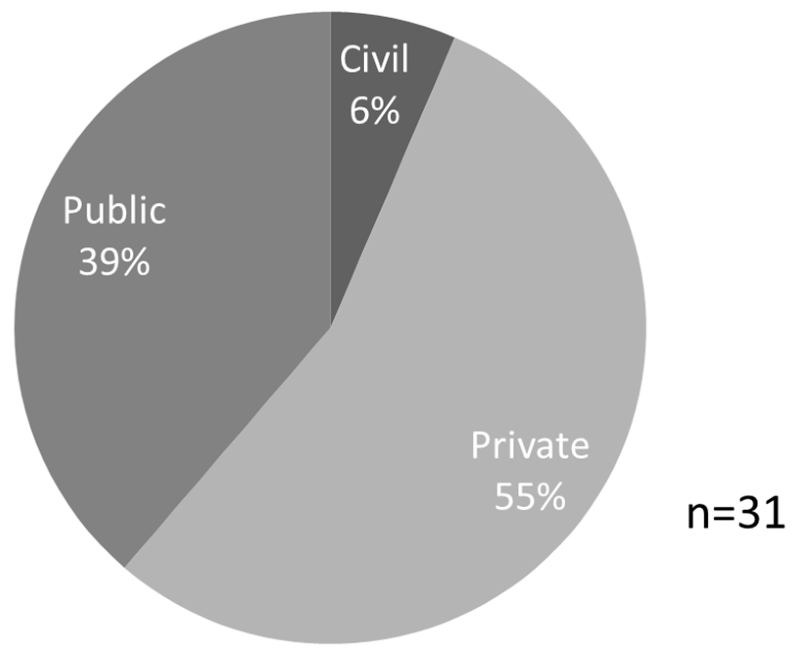
3.3. Landscape Stakeholders

A total of 31 stakeholders were identified in the lower part of the Kovda River catchment. These were land leasers (13), forest contractors (9), forest users (6) and potential forest contractors (3). Private sector stakeholders made up 55% (Figure 4). They represented enterprises working with small-scale logging, tourism and agriculture. The civil sector was represented only by a local gardening society. Public sector stakeholders represented managed forests (Kovdozersky state forest management unit), water (the Kovda hydropower station) and protected areas. Private sector stakeholders stressed the need to develop new business activities. These were very diverse and ranged from small-scale based on local wood resources, farming and fisheries, tourism (e.g., nature-based, sport, fishing including maintenance and restoration of fish population and hunting) and to the construction of bio-fuel stations for central heating in towns and villages.
The interviews also showed that the stakeholders in the area used landscape goods, services and values in different ways (Table 3). The stakeholders with direct use of natural resources were from public and private sectors, which were concerned with the extraction of natural resources including wood, fish and game, as well as the use of kinetic energy of water to produce electricity by the establishment of several large water reservoirs and dams. These stakeholders had the most substantial effect on the physical landscape. Additionally, sport hunting for grouse, ducks and moose was the aim for several landscape stakeholders. Over-intensive hunting could affect the population size and productivity of prey species, and thus create customer bad-will. It was therefore felt necessary to assure that hunting pressure can be maintained, as well as to identify areas with suitable habitat for different species.
There were many challenges for stakeholders representing the forest industry, based on local forest resources. After a 50-year history of intensive wood harvesting amounting to 700,000 m3/year in the 1980s, currently, only about 10,000 m3 is harvested annually [55]. According to the current state forest management plan, about 100,000 m3 can be harvested annually. However, the possible final felling stands are located far away from today’s transport infrastructure. The reason is that logging in the area was made as a frontier into un-harvested old-growth forest from each of the different logging villages. This is an illustration of the problem of the inaccessibility of the estimated annually allowable harvest. To combine silviculture by commercial thinning to improve stands, and to produce bio-energy assortments, there were discussions about introducing central heating based on wood chips.
Another group of stakeholders delivered services in terms of recreation and tourism. This natural resource use was largely non-consumptive. Indirect use values were derived from the landscape values linked to primary forest remnants. For example, wilderness tourism has been established (e.g., https://vk.com/bazaiova). Annually >5000 people visit the Paanajärvi National Park. The area used for these tours was large and included long-distance river trips, and snowmobile safaris from Finland to the White Sea. At the same time the largest group of visitors of the Loukhsky District (65% of total inbound tourism) comes from Moscow and Saint Petersburg, and organise the visit themselves [86], a group which is difficult to reach in processes of multi-stakeholder collaboration.
The non-use values of the landscape were of importance to a fewer number of stakeholders. The recognised non-use values consisted of existence values, which were closely linked to nature conservation interests, and bequest values that, in addition, encompass cultural heritage conservation interests. Protected areas aimed at biodiversity conservation and forests with protective [87] and social functions [88] form a key Green Belt infrastructure. For example, 34% of the total forest area of the Kovdozersky forest management unit was excluded from forest exploitation for ecological reasons [55]. However, interviewees expressed the opinion that biodiversity conservation was not an urgent issue in the area. Simultaneously, stakeholders reported that culture tourism was emerging. The village of Kestenga in the Loukhsky District is an example of the rune-song villages that have preserved their ancient traditions [47]. The shores of the White Sea have a very long history of human settlement. The Pomor people culture was well represented in the Kovda village, located at the mouth of the Kovda River. For those interested in the history of forest use, another interesting village was Lesozavodskiy, which was created to produce sawn wood and to provide a port for export. The Russian-Finnish border moved considerably to the west after the Finnish winter war in the 1940s. The land lost to Russia hosts several ancient Finnish settlements, which are important for upholding cultural traditions and as tourist attractions.
The final group of stakeholders was formed by control authorities. While these stakeholders did not use the natural resources actively, they had an important law enforcement function counteracting unwanted use of natural resources. The administration of the Kovdozersky forest management unit, local administration, railroad and road authorities were some examples.
All stakeholders in the Russian part of Kovda River catchment had many opportunities for collaboration. Our study of the management interactions among landscape stakeholders (Figure 5) indicated that: (1) there was a group of “well-integrated” stakeholders like the administration of the forest management unit and the local administrations; (2) some stakeholders had “one-way” interaction, which means that they coordinated their management activity with only one stakeholder (for example, administration of the Kutsa nature reserve and tourism enterprises); (3) “outsiders”–stakeholders, who did not integrate their activities with others. For example, the administration of hydro-power stations did not interact with landscapes’ stakeholders at all. The interviews with landscapes’ stakeholders allowed us to make suggestions about their role in local development of different dimensions of sustainability (Figure 6). The majority of stakeholders contributed to the economic and social development, which means that there is a need to encourage and increase the attention to ecological and cultural issues.

3.4. Spatial Levels of Forest Landscape Use

The spatial extents of stakeholder activities ranged from local to international. However, almost half of the stakeholders focused on the Murmansk region (Figure 7). Thus, the goods, services and values of the landscape cover multiple spatial scales (Table 4).
The main planning units in the Russian part of the Kovda River catchment were the four forest management units Kandalakshsky, Kovdozersky in Murmansk, and Pyaozersky and Chupinsky in the Republic of Karelia. An important task for them was to enhance co-existence of forest land leasers operating at different spatial scales. For example, in the Kovdozersky forest management unit, 17 stakeholders leased different parts of this area to operate businesses based on wood harvesting, hunting and recreation. To secure sustainable use of goods, services and values, their states and spatial distributions need to be mapped. This applies to wood resources for timber and biomass for bioenergy, habitat availability for game and fish, nature and culture values as bases for tourism, opportunities for hydro-electric development and for nature conservation through protected area networks. Some users expressed a need for regional trans-boundary planning covering the entire Kovda River catchment, i.e., in Murmansk oblast, the Republic of Karelia and Finland. Three examples are hydro-electric development, tourism linked to the Finnish and Russian cultural heritage in the border zone between the two countries, and the conservation of one of Fennoscandia’s intact forest landscapes located entirely within the Kovda River catchment.

4. Discussion

4.1. A Diversity of Boreal Forest Landscape Perspectives

In the light of climate change and globalisation, boreal forest conservation has become a key issue [50,89,90,91]. To sustain primeval forests as a core value in large intact forest landscape remnants, there is a need to reconcile the needs and desires of landscape stakeholders at the local and regional level with national and international policies related to biodiversity conservation and sustainable development [37,92,93]. Given a range of drivers, like biodiversity conservation, globalisation of economies, energy supply and climate change and Russian wood export tariffs, decision-makers at multiple levels need to learn about these issues and how to handle them, and how to cope with uncertainty and risk [94,95].
From the Kovda River catchment’s perspective the economic use of once primeval forests since the ceding of the Salla area to the Soviet Union in 1940 (see Figure 1) spread from the White Sea in the east and upstream. While forest logging in the catchment began in the late 19th century along the White Sea coast [70], it only became intense in the 1950s, and at present, forestry for wood production has declined dramatically [55]. As a consequence of its regional remoteness and associated values Russian-Finnish cooperation has prospered [96,97]. Nevertheless, rural settlements are in decline, and locals rely on a wide range of wood and non-wood resources [44,52,98,99]. While hydropower production continues, planning measures are discussed to increase the reliability and safety of hydraulic structures, due to the poor quality of constructions and the limited consideration of local operating conditions [100], as well as to develop compensation measures for lost fish industry opportunities [101]. At the same time, tourism based on natural and cultural values is emerging [102].
The development since the early 1950s can thus be described as a transition from an industrial society based on hydro-electric development, mining and the clear-felling of primeval forests, which indeed gave many people jobs and created resource-dependent rural communities during a relatively short period of time, to declining local societies in Russia. In contrast, the combined use of wood and non-wood goods, services and values are emerging in Finland [103,104,105].
There are also attempts to develop cross-border tourism between Finnish Lapland and southern Kola region based on natural and cultural heritage [106]. Tourism development program work is currently also going on in the Murmansk region. This strategy concentrates mostly on development of cross-border tourism in the Kovda River catchment. The main attractions for tourism are nature protected areas with unique boreal primeval forests and wild rivers.
Our study shows that the range of values people associate with forest landscapes is wide. We conclude that: (a) the values are new and evolving, and many stakeholders are not prepared for this; (b) the demands to deliver goods, services and values from forest landscapes are steadily increasing; (c) the rate of range is accelerating, and there is a need for continued assessment of ecological, economic and socio-cultural consequences; (d) there is an urgent need for collaboration among sectors within a geographical area to avoid losing desired values.
Regarding the history and culture of forest landscapes in the border zone between Finland and Russia, Lehtinen [44] stated “The violent past of the region stands as clear proof that this multitude of can only be supported and developed by prioritizing culturally and ecologically sensitive means of cooperation across the border, instead of large-scale industrial, ecological or geopolitical projections controlled from the outside”.
The interviews with stakeholders in the Kovda River catchment clearly show a much wider range of spatial scale of forest landscape use than in the past. This is consistent with the pattern of globally emerging efforts towards multi-level participation of actors and stakeholders representing private businesses, public organisations and civil society. Therefore, we conclude that a sustainable forest landscape requires integrated spatial planning at multiple spatial scales, and landscape stewardship based on multi-level governance [95]. The emergence of new and the deepening of existing cross-border links between sectors (forest, mining and tourism) is pivotal for sustainable local land-use and natural resource use policies [107].

4.2. Spatial Planning for Sustainable Forest Landscapes

4.2.1. Trees in Stands

Data about species, density, size and volume of trees, as well as site conditions form the basis for operational economic forest planning aimed at wood harvest and sustained yield wood production. In addition to site conditions affecting growth and transport infrastructure, tree data forms the base for dividing a management unit into forest stands with homogenous properties [108]. To mitigate problems caused by forestry intensification for biodiversity conservation retention, forest certification has promoted set-aside of woodland key biotopes, such as paludified forest patches, buffers around water bodies, habitats of red-listed species, as well as of dispersed retention of living trees, snags and dead wood [109,110]. However, Blumröder et al. [111] stressed that the effectiveness of stand-scale conservation instruments has to be assessed, with respect to edge effects and secondary dieback of retention trees and patches. For example, while Russia has a unique history of forest zoning separating production and environmental functions, however, the Russian Forest Code of 2006 increased the focus on wood production. In turn, this increased harvest rates in stream buffer zones [87]. Moreover, even if effective, these stand-level conservation efforts do not help to solve conservation problems related to birds, mammals and fish, all of which have landscape scale requirements.

4.2.2. Stands in a Management Sub-Unit

To carry out logging operations, there is a need to develop a sufficiently dense network of forest roads that can be used at least seasonally for wood mining. Given that the cost for terrain transport using forwarders is higher than road-transport hauling with trucks, there is a need for a dense road network, especially if multiple forest silvicultural treatments are planned within a management unit. The cost to transport timber with an all-terrain forwarder rapidly increases for distances over 500m [108]. Therefore, focusing on intensive forest management, the Swedish road plan 1990 aimed at leaving no point in the managed forests more than 500 m away from a forest road, allowing hauling by trucks [112]. Sundberg & Silversides [108] estimated the total density of main artery roads, secondary and feeder roads required to 15–25 m per hectare. In the Republic of Karelia and the Murmansk region, the road density is about 2 m per hectare [113].
International and national biodiversity conservation policy commits forest actors to maintain viable populations of naturally occurring species. The emergence of spatial planning of forest stands with different properties in a forest management unit in Nordic forestry is linked to the maintenance of species that cannot cope with the simplification of the forest ecosystem that sustained yield forest forestry causes [114,115]. The reduction of dead wood, old deciduous trees, old forest stands and functional habitat networks are four examples. Termed ecological landscape planning or landscape ecological planning Swedish and Finnish private and state forest companies developed approaches to support the presence of different lichen, moss, fungal and insect species, by setting aside stands with natural forest structures (e.g., woodland key habitats) [116].
However, to maintain boreal biodiversity according to policy means, at least, that a minimum amount of habitat patches with sufficient quality, size and concentration is needed for each forest ecosystem type in every ecoregion. The Swedish state forest company Sveaskog is a good example. This company has used ecological knowledge to set a target of 20% of the productive (i.e., more than one m3/ha and year) forest landscape to be set aside for nature conservation, and to design local and regional networks of different forest ecosystems that represent the five main different natural ecoregions in Sweden. The target of 20% in each ecoregion is reached by leaving individual trees, tree corridors, groups and patches of trees, as well entire forest stands. About half of the ecoregional targets are made up by sub-stand level retention, and half by setting aside entire stands (S. Bleckert pers. comm.). In Russia, the national FSC standard could be viewed as an example of bringing biodiversity considerations with high level of ambitions to the forest management. The indicators in the Russian FSC standard require the maintenance of communities of naturally occurring species and to some extent ecological integrity of the representative ecosystems of an eco-region [109,117]. On this scale, the planning for social-cultural issues could be done for the maintenance of non-wood forest products, which are important for local people during the transition period [88].

4.2.3. Landscapes in Management Unit

As is the case of early industrial use of wood resources anywhere, Soviet wood harvesting was based on what can be called wood mining. The transition from this system, combined with a planned economy, to the current broad range of forest landscape goods, services and values, puts new demands on spatial planning across several forest owners, leasers and users. This general trend is clearly corroborated by the different forest users in the Kovda River catchment.
After a 50-year history of old-growth logging, final felling stands are located far away from today’s transport infrastructure. The reason is that logging was made as a wood mining frontier from each of the different logging villages, now by and large abandoned. This is an illustration of the problem of the inaccessibility of the allowable harvest, which often in reality result in severe local overharvesting. As a consequence, thousands of hectares of forests around abandoned forest villages are young to middle-aged never pre-commercially cleaned nor thinned forest stands. To combine silviculture for improved stands and to produce bioenergy, there are discussions about introducing central heating in larger settlements based on wood chips, which are produced locally from the wood after thinning to improve stands. Currently produced wood chips are mainly sold abroad. Sport hunting for grouse, ducks and moose is the aim for several landscape stakeholders. Intensive hunting does affect the population size and productivity of prey species. It is therefore necessary to assure that hunting pressure can be maintained, as well as to identify areas with a suitable habitat for different species. Another issue is the representation of different forest types for biodiversity conservation. While the Paanajärvi and Kutsa primeval forest massifs are indeed large, most of them are located at >300 m a.s.l., which is less preferred by focal species such as the flying squirrel [118]. It is thus necessary to assess the functionality of different forest habitat networks at the scale of landscapes at the regional level [22].
The mapping of high conservation value forests (e.g., intact forest landscape with primeval forests) needs to be made at multiple scales, from that of large region, local landscapes, to the scale of trees in stands at the local level [119]. An interesting approach to integrated landscape planning within ecoregions was developed by Sveaskog Co. in Sweden. Based on the insight that habitat network functionality is alleviated by concentrating set-asides of high conservation value forest, Sveaskog Co. made analyses of all their management units to map high conservation value areas in Sweden. The management units with the highest natural values in each ecoregion are termed Ekopark [120]. Here, the local proportion of set-aside areas for biodiversity conservation is 30%–50%. Indeed, this approach has led to better habitat network functionality than other forest owner categories focusing on wood production.
At this spatial scale, planning for maintenance of cultural landscapes, which have high cultural, social and ecological values, according to international and national policies [25], is an important issue. The traditional villages in the Kovda River catchment reflect the ancient cultural and land use traditions of the Pomor people. Spatial planning for protection of cultural landscapes and traditional village systems should be a milestone in a regional program designated for keeping cultural diversity and social stability of forest landscapes. The village system intactness would be a good partial indicator of success [121]. Since the 1990s, when the benefits of tourism development became apparent, the Republic of Karelia developed, and has continuously improved, a system of strategic management. The 2007 General Layout of Tourist Sights and Tourism Infrastructure in the Republic of Karelia identified twelve tourism zones, one of which being the Pyaozersky zone, located in the Loukhsky District border districts [47,80]. At the municipal level, the significance of tourism development has been emphasised in the programme for the socio-economic development of the Louksky District. In general, the implementation of the programme for tourism development will increase the contribution of the industry to the socio-economic development of the area, enhance their investment attractiveness and create a competitive tourism product [122].

4.2.4. Ecoregional Level

Several landscape stakeholders used goods, services and landscape values at a spatial scale encompassing the entire Kovda River catchment from Finland to the White Sea and further. Three examples are stakeholders working with the conservation of primeval forests, cross-border tourism and hydro-electric development.
The main focus of conservation is the primeval forests along the Russian-Finish border. Although very large, the boreal forest region has been transformed from its naturally dynamic state by various anthropogenic effects. Gradually expanding frontiers of clear-felling is a major impact. Being remote from centres from economic development in Russia, and not accessible from the Finnish side, a “Green Belt” of large intact forest landscapes is located immediately east of the Finnish-Russian border [44]. Focusing on the northern boreal forest ecoregion, one of these large intact forest landscapes is formed by the Paanajärvi-Kutsa wilderness in the upper part of the Kovda River catchment. Apart from the “Green Belt” forests, other main reference areas to understand the natural range of variability are the forest massifs at the border between the Republic of Karelia and the Arkhangelsk oblast, the Dvina-Pinega watershed, and the forest complex along the western slopes of the Ural Mountains, made up by Yugud-Va National Park and the Pechora-Ilych zapovednik, and its buffer zone in the Unya River catchment in the Komi Republic [12,123]. Efimov [124] presented a masterplan for a collection of primeval forest areas in Northwest Russia to provide ecosystem corridors in both east-west and south-north directions and for the Barents Region. It is essential that assessments of the functionality of protected area networks are made [125,126]. For example, a review of protected areas in Murmansk Oblast by Borovichev et al. [127] concluded that effective environmental protection is provided only by state nature reserves and national parks, (4.2% of the Murmansk Oblast), and that “it is hardly possible to guarantee the proper level of biodiversity conservation and the stability of the ecosystem of the region”.
The appearing cross-border tourism development is based mainly on ecological and cultural values of forest landscapes [5,105,128]. To reconcile the interests of forestry, nature conservation and rural development spatial planning for entire the Kovda River catchment in needed. Similarly, the production of electricity by the Kovda hydro-power stations for the customers on national and international levels require spatial planning to integrate the interests of tourism development, conservation of biodiversity, local fisheries and forestry. Table 5 outlines how planning for ecological, economic and socio-cultural dimensions of sustainable use and governance of forest landscapes takes place at multiple spatial scales.

4.3. Landscape Approach to Conservation and Use of Primeval Forests

European regions holding valuable natural and cultural heritage are often located across state borders, especially if linked to topography or other features that hampered economic development [129,130,131]. In general, East European countries have more intact biodiversity compared to Western Europe, including species, habitat networks and natural processes [132] and cultural values [121,133]. However, at present, regions located along the eastern border of EU stand at a crossroad [134]. First, this is between continued decline of biological and cultural diversity, aggravated by continued wood mining [22,87] and bio-economic policy, aimed at intensified biomass production [135]. Second, it is about developing new approaches to landscape stewardship and the management of landscapes and regions that are built not only on wood products, but also on a wide range of landscape values as a base for nature-based tourism [91,136]. For example, in Poland, conflicts between existing ecological habitat networks and improved road networks [137] and intensified forestry and tourism development [24,138,139] are currently occurring along the Polish-Belarus border.
This urgent conservation challenge calls for the identification of landscape stewardship platforms for co-operation and implementation of cross-border management mechanisms at local, regional, national and transnational levels. Steering towards sustainable landscape stewardship means “a place-based, landscape-scale expression of broader ecosystem stewardship” [140] that maintains natural capital. This requires knowledge and skills to navigate the complexity of interactions within landscapes’ social systems, through an inclusive societal learning process [30]. These efforts must also support communication, education and public awareness about the state and trends of all dimensions of sustainability. Working towards the sustainable development of landscapes using governance and landscape stewardship requires special emphasis on finding a common platform for the inclusion of ecological, economic, socio-cultural values, as well as approaches towards a system of good governance. Adaptation and learning requires an iterated procedure that involves multi-level co-operation among disciplines, sectors and actors [141,142]. To achieve this, a transdisciplinary approach should be applied [143]. This means that both human and natural science disciplines need to be included, as well as stakeholders using natural resources, all with the aim to balance landscape values from policy to practice, and back again [144]. Transdisciplinary research has four features that separate it from disciplinary sciences [142]: (1) it develops an evolving framework to guide problem solving efforts, which focuses on achieving holistic understanding; (2) it develops its own theoretical structure, research methods and modes of practice, based on the input from different disciplines; (3) unlike the disciplinary sciences, where results are communicated through institutions, knowledge production is communicated by those (practitioners and scientists) who have participated in the work; (4) it is about problem solving on the move. Thus, communication in ever new configurations is crucial. Landscape is an important concept within humanities and social sciences, as well as natural sciences [36,145]. The landscape concept can thus be used as an interface for improved communication between human and natural sciences, as well as between policy and practice, to increase the understanding of dependencies between social and ecological systems. Such a landscape approach is characterised by a focus on five core features: (1) a geographical area, (2) collaboration among stakeholders, (3) a commitment to sustainable development, (4) knowledge production, and (5) sharing of knowledge and experiences [146]. In the downstream part of the Kovda River catchment, the Kovdozersky Model Forest was such an initiative [55,147]. Cross-border co-operation (CBC) is another new form of governance, as an essential part of the Pan-European integration process for overcoming historic divisions, eliminating stereotypes in mutual perception, strengthening good-neighbourly relations between nations, ensuring stability, peace and socio-economic development [121,148]. The need to consider political, institutional and organisational dimensions of such initiatives, their abilities to create a landscape strategy for guiding the future development, and what they achieve on the ground in actual landscapes, is a major task for policy and decision makers and for research [62,95,149]. Financing a suite of cross border landscape strategies with the purpose of gaining experiences with such collaborative processes would be valuable. Recent reviews about the landscape approach concepts model forest [147] and Long-Term Socio-Ecological Research (LTSER) platform [150] provide systematic analyses of barriers and bridges [151].

5. Conclusions

This case study about the eastern external border of the European Union as a transition zone between Europe’s East and West is a clear example of how different political and economic histories, as well as governance systems, have created large contrasts in social-ecological systems between adjacent regions. Following the Soviet era of wood mining, the remaining primeval forest and cultural heritage remnants are located along the Russian side of Finnish-Russian border. That the recent forest canopy loss is higher in Finland (0.42%/year) than in Russia (0.09%/year) is advantageous for primeval forest conservation in Russia. We argue that the planning of a collaborative development direction involving different landscape stakeholders, regional and municipal authorities, as well as local citizens, is crucial for future sustainable multiple landscape uses in the Kovda River catchment. Wilderness based on primeval forest conservation in large intact forest landscapes and cultural landscapes are key assets, and product development built on non-wood forest goods is emerging in new kinds of value chains. To avoid conflicts between non-use and use values, there is a need for an integrated social-ecological approach. This involves: (1) assessment and communication about the states and trends of different dimensions of sustainable forest landscapes; (2) empowering stakeholders towards collaborative learning and landscape stewardship built on multi-level governance; and (3) undertaking spatial planning at multiple spatial scales to reconcile primeval forest conservation with the needs and interests of different landscape stakeholders.

Author Contributions

Conceptualization, P.A.; methodology, P.A., M.M.; formal analysis, P.A., M.M.; writing—original draft preparation, P.A.; writing—review and editing, P.A., M.M.; T.Y., O.J.S., S.V.K.; project administration, P.A., S.V.K.; funding acquisition, P.A., S.V.K. All authors have read and agreed to the published version of the manuscript.

Funding

This work was initiated in the frame of the EU InterReg ‘‘Baltic Forest’’ project, and was supported.by grants from Marcus and Amalia Wallenbergs Minnesfond and FORMAS [grant numbers 2011-1737 and 2017:1342] to Per Angelstam. Svetlana V. Kondrateva’s (Stepanova) contribution was as part of the implementation of State Order No. AAAA-A19-119010990088-8 of 19.01.2019 “Methodology of system research and management development of the economic, social and cultural space of the northern and border areas of Russia in the context of national security”.

Acknowledgments

We thank the partners in the EU InterReg ‘‘Baltic Forest’’ project, in particular Marine Elbakidze, and the Kovdozersky Model Forest partnership, as well as interviewees in Zelenoborsk and the Kovda River catchment for their time and valuable contributions. We thank Eugene Borovichev for inspiring comments.

Conflicts of Interest

The authors declare no conflict of interest. The funders had no role in the design of the study; in the collection, analyses, or interpretation of data; in the writing of the manuscript, or in the decision to publish the results.

References

  1. Carlson, M.; Wells, J.; Roberts, D. The Carbon the World Forgot: Conserving the Capacity of Canada’s Boreal Forest Region to Mitigate and Adapt to Climate Change; Boreal Songbird Initiative and Canadian Boreal Initiative: Seattle, WA, USA, 2009. [Google Scholar]
  2. Myneni, R.B.; Dong, J.; Tucker, C.J.; Kaufmann, R.K.; Kauppi, P.E.; Liski, J.; Zhou, L.; Alexeyev, V.; Hughes, M.K. A large carbon sink in the woody biomass of Northern forests. Proc. Natl. Acad. Sci. USA 2001, 98, 14784–14789. [Google Scholar] [CrossRef] [Green Version]
  3. Yaroshenko, A.; Potapov, P.; Turubanova, S. The last intact forest landscapes of Northern European Russia. Greenpeace Russia and Global Forest Watch, Moscow. In The Last Large Intact Forests in North-West Russia; Greenpeace Russia: Moscow, Russia, 2001; p. 93. [Google Scholar]
  4. Kojola, I.; Tuomivaara, J.; Heikkinen, S.; Heikura, K.; Kilpeläinen, K.; Keränen, J.; Paasivaara, A.; Ruusila, V. European Wild Forest Reindeer and Wolves: Endangered Prey and Predators. Ann. Zool. Fenn. 2009, 46, 416–422. [Google Scholar] [CrossRef] [Green Version]
  5. Nilsson, C.; Reidy, C.A.; Dynesius, M.; Revenga, C. Fragmentation and Flow Regulation of the World’s Large River Systems. Science 2005, 308, 405–408. [Google Scholar] [CrossRef] [Green Version]
  6. Pastor, J.; Light, S.; Sovell, L. Sustainability and Resilience in Boreal Regions Sources and Consequences of Variability. Conserv. Ecol. 1998, 2, 16. [Google Scholar] [CrossRef] [Green Version]
  7. Kuuluvainen, T. Forest Management and Biodiversity Conservation Based on Natural Ecosystem Dynamics in Northern Europe: The Complexity Challenge. AMBIO 2009, 38, 309–315. [Google Scholar] [CrossRef] [PubMed]
  8. Kuuluvainen, T.T. Disturbance dynamics in boreal forests: Defining the ecological basis of restoration and management of biodiversity. Silva Fenn. 2002, 36, 5–11. [Google Scholar] [CrossRef]
  9. Angelstam, P.; Manton, M.; Green, M.; Jonsson, B.-G.; Mikusinski, G.; Svensson, J.; Sabatini, F. High Conservation Value Forest remnants in Sweden do not satisfy agreed biodiversity targets: A call for adaptive landscape planning. Landsc. Urban Plan. 2020, in press. [Google Scholar]
  10. Lilja, S.; Kuuluvainen, T. Structure of old Pinus sylvestris dominated forest stands along a geographic and human impact gradient in mid-boreal Fennoscandia. Silva Fenn. 2005, 39, 407. [Google Scholar] [CrossRef] [Green Version]
  11. Lilja, S.; Wallenius, T.; Kuuluvainen, T. Structure and development of old Picea abies forests in northern boreal Fennoscandia. Écoscience 2006, 13, 181–192. [Google Scholar] [CrossRef]
  12. Angelstam, P.K.; Anufriev, V.M.; Balciauskas, L.; Blagovidov, A.K.; Borgegård, S.-O.; Simon, J.H.; Majewski, P.; Ponomarenko, S.V.; Shvarts, E.A.; Tishkov, A.A.; et al. Biodiversity and sustainable forestry in European forests: How East and West can learn from each other. Wildl. Soc. Bull. 1997, 25, 38–48. [Google Scholar]
  13. Angelstam, P.; Axelsson, R.; Elbakidze, M.; Laestadius, L.; Lazdinis, M.; Nordberg, M.; Pătru-Stupariu, I.; Smith, M. Knowledge production and learning for sustainable forest management on the ground: Pan-European landscapes as a time machine. Forestry 2011, 84, 581–596. [Google Scholar] [CrossRef] [Green Version]
  14. Burnett, C.; Fall, A.; Tomppo, E.; Kalliola, R. Monitoring Current Status of and Trends in Boreal Forest Land Use in Russian Karelia. Conserv. Ecol. 2003, 7, 8. [Google Scholar] [CrossRef] [Green Version]
  15. Kuuluvainen, T.; Laiho, R. Long-term forest utilization can decrease forest floor microhabitat diversity: Evidence from boreal Fennoscandia. Can. J. For. Res. 2004, 34, 303–309. [Google Scholar] [CrossRef]
  16. Ovaskainen, O. Survey of Old-Growth Forests in North-West Russia; Finnish Nature League Publications: Helsinki, Finland, 1998. [Google Scholar]
  17. Angelstam, P. Maintaining and restoring biodiversity in European boreal forests by developing natural disturbance regimes. J. Veg. Sci. 1998, 9, 593–602. [Google Scholar] [CrossRef]
  18. Pennanen, J. Forest age distribution under mixed-severity fire regimes-a simulation-based analysis for middle boreal Fennoscandia. Silva Fenn. 2002, 36, 213–231. [Google Scholar] [CrossRef] [Green Version]
  19. Pennanen, J.; Kuuluvainen, T. A spatial simulation approach to natural forest landscape dynamics in boreal Fennoscandia. For. Ecol. Manag. 2002, 164, 157–175. [Google Scholar] [CrossRef]
  20. Müller, J.; Bütler, R. A review of habitat thresholds for dead wood: A baseline for management recommendations in European forests. Eur. J. For. Res. 2010, 129, 981–992. [Google Scholar] [CrossRef]
  21. Drobyshev, I.; Niklasson, M.; Angelstam, P. Contrasting tree-ring data with fire record in a pine-dominated landscape in the Komi Republic (Eastern European Russia): Recovering a common climate signal. Silva Fenn. 2004, 38, 43–53. [Google Scholar] [CrossRef] [Green Version]
  22. Naumov, V.; Manton, M.; Elbakidze, M.; Rendenieks, Z.; Priednieks, J.; Uhlianets, S.; Yamelynets, T.; Zhivotov, A.; Angelstam, P. How to reconcile wood production and biodiversity conservation? The Pan-European boreal forest history gradient as an “experiment”. J. Environ. Manag. 2018, 218, 1–13. [Google Scholar] [CrossRef]
  23. Manton, M.; Angelstam, P. Defining Benchmarks for Restoration of Green Infrastructure: A Case Study Combining the Historical Range of Variability of Habitat and Species’ Requirements. Sustainability 2018, 10, 326. [Google Scholar] [CrossRef] [Green Version]
  24. Blicharska, M.; Angelstam, P. Conservation at risk: Conflict analysis in the Białowieża Forest, a European biodiversity hotspot. Int. J. Biodivers. Sci. Ecosyst. Serv. Manag. 2010, 6, 68–74. [Google Scholar] [CrossRef] [Green Version]
  25. European Landscape Convention. European Landscape Convention and Reference Documents; Council of Europe: Florence, Italy, 2000. [Google Scholar]
  26. Montréal Process. Criteria and Indicators; Liason Office: Tokyo, Japan, 2009. [Google Scholar]
  27. European Commission. Directive, 2000/60/EC of the European Parliament and of the Council of 23rd October 2000. Establishing a Framework for Community Action in the Field of Water Policy; European Commission: Brussels, Belgium, 2000. [Google Scholar]
  28. Lammerts Van Bueren, E.M.; Blom, E.M. Hierarchical Framework for the Formulation of Sustainable Forest Management Standards; Tropenbos Foundation Wageningen: Wageningen, The Netherlands, 1997. [Google Scholar]
  29. Mayers, J.; Bass, S. Policy that Works for Forests and People: Real Prospects for Governance and Livelihoods; Earthscan: London, UK, 2004. [Google Scholar]
  30. Baker, S. Sustainable Development; Routledge: London, UK, 2006. [Google Scholar]
  31. Rauschmayer, F.; Berghöfer, A.; Omann, I.; Zikos, D. Examining processes or/and outcomes? Evaluation concepts in European governance of natural resources. Environ. Policy Gov. 2009, 19, 159–173. [Google Scholar] [CrossRef]
  32. European Commission. Green Infrastructure (GI)—Enhancing Europe’s Natural Capital; Communication from the commission to the European Parliament, the Council, the European Economic and Social Committee and the Committee of the regions; European Commission: Brussels, Belgium, 2013. [Google Scholar]
  33. Merlo, M.; Croitoru, L. Concepts and methodology: A first attempt towards quantification. In Valuing Mediterranean Forests. Towards Total Economic Value; Merlo, M., Croitoru, L., Eds.; CABI: Wallingford, UK, 2005; pp. 17–36. [Google Scholar]
  34. Tysiachniouk, M. Conflict as a form of governance: The market campaign to save the Karelian Forests. In The Changing Governance of Renewable Natural Resources in Northwest Russia; Nysten-Haarala, S., Ed.; Ashgate: London, UK, 2009; pp. 169–196. [Google Scholar]
  35. Primdahl, J.; Søderkvist Kristensen, L.; Arler, F.; Angelstam, P.; Aagaard Christensen, A.; Elbakidze, M. Rural landscape governance and expertise—On landscape agents and democracy. In Defining Landscape Democracy: A Path to Spatial Justice; Egoz, S., Jorgensen, K., Ruggeri, D., Eds.; Edward Elgar Publishing: Cheltenham, UK, 2018; pp. 153–164. [Google Scholar]
  36. Angelstam, P.; Grodzynskyi, M.; Andersson, K.; Axelsson, R.; Elbakidze, M.; Khoroshev, A.; Kruhlov, I.; Naumov, V. Measurement, collaborative learning and research for sustainable use of ecosystem services: Landscape concepts and Europe as laboratory. AMBIO 2013, 42, 129–145. [Google Scholar] [CrossRef] [Green Version]
  37. Rannikko, P. Combining Social and Ecological Sustainability in the Nordic Forest Periphery. Sociol. Rural. 1999, 39, 394–410. [Google Scholar] [CrossRef]
  38. Ramakrishnan, P.S. Ecology and Sustainable Development; National Book Trust: New Delhi, India, 2001.
  39. Peterson, G. Political ecology and ecological resilience: An integration of human and ecological dynamics. Ecol. Econ. 2000, 35, 323–336. [Google Scholar] [CrossRef]
  40. Angelstam, P.; Mikusiński, G.; Rönnbäck, B.-I.; Östman, A.; Lazdinis, M.; Roberge, J.-M.; Arnberg, W.; Olsson, J. Two-dimensional gap analysis: A tool for efficient conservation planning and biodiversity policy implementation. AMBIO 2003, 32, 527–534. [Google Scholar] [CrossRef]
  41. Lazdinis, M.; Angelstam, P. Connecting social and ecological systems: An integrated toolbox for hierarchical evaluation of biodiversity policy implementation. Ecol. Bull. 2004, 51, 385–400. [Google Scholar]
  42. Norton, B.G. Sustainability: A Philosophy of Adaptive Ecosystem Management; University of Chicago Press: Chicago, IL, USA, 2005. [Google Scholar]
  43. Engels, B.; Heidrich, A.; Nauber, J.; Riecken, U.; Schmauder, H.; Ullrich, K. “Perspectives of the Green Belt” Chances for an Ecological Network from the Barents Sea to the Adriatic Sea? Bundesamt für Naturschutz: Bonn, Germany, 2004.
  44. Lehtinen, A.A. Postcolonialism, Multitude, and the Politics of Nature; University Press of America Lanham: Lanham, MD, USA, 2006. [Google Scholar]
  45. Terry, A.; Ullrich, K.; Riecken, U. The Green Belt of Europe: From Vision to Reality; IUCN: Glan, Switzerland, 2006. [Google Scholar]
  46. Titov, A.; Butorin, A.; Gromtsev, A.; Ieshko, E.; Kryshen, A.; Saveliev, Y.V. Green belt of Fennoscandia: State and development prospects. In Trudy Karel’skogo Nauchnogo Tsentra Rossiiskoi Akademii Nauk; Russian Academy of Sciences: Petrozavodsk, Russia, 2009; p. 3. [Google Scholar]
  47. Stepanova, S.V. Tourism development in border areas: A benefit or a burden? The case of Karelia. Balt. Reg. 2019, 11, 94–111. [Google Scholar]
  48. Heikkilä, R.; Lindholm, T. Biodiversity and Conservation of Boreal Nature; Kainuu Regional Environment Centre; The Finnish Environment: Helsinki, Finland, 2003; Volume 485. [Google Scholar]
  49. Juvonen, S.-K.; Kuhmonen, A. Evaluation of the Protected Area Network in the BarentsRegion–Using the Programme of Work on Protected Areas of the Convention on BiologicalDiversity as a Tool; Reports of the Finnish Environment Institute; Finnish Environment Institute: Helsinki, Finland, 2013; Volume 37, pp. 1–309. [Google Scholar]
  50. Potapov, P.; Yaroshenko, A.; Turubanova, S.; Dubinin, M.; Laestadius, L.; Thies, C.; Aksenov, D.; Egorov, A.; Yesipova, Y.; Glushkov, I.; et al. Mapping the World’s Intact Forest Landscapes by Remote Sensing. Ecol. Soc. 2008, 13. Available online: http://www.ecologyandsociety.org/vol13/iss2/art51/ (accessed on 8 May 2020). [CrossRef] [Green Version]
  51. Berglund, E. From Iron Curtain to Timber-Belt. Ethnol. Eur. 2000, 30, 23–34. [Google Scholar]
  52. Lehtinen, A. The Fall of Forest Villages: Ecological and Cultural Conflicts in the Russian Taiga. Research Programme on Environmental Policy and Society (EPOS); Research Report 1; Uppsala University: Uppsala, Sweden, 1993. [Google Scholar]
  53. Lehtinen, A.; Rytteri, T. Backwoods’ provincialism: The case of Kuusamo Forest Common. Nordia 1998, 27, 27–37. [Google Scholar]
  54. Siiskonen, H. The conflict between traditional and scientific forest management in 20th century Finland. For. Ecol. Manag. 2007, 249, 125–133. [Google Scholar] [CrossRef]
  55. Elbakidze, M.; Angelstam, P.; Axelsson, R. Sustainable forest management as an approach to regional development in the Russian Federation: State and trends in Kovdozersky Model Forest in the Barents region. Scand. J. For. Res. 2007, 22, 568–581. [Google Scholar] [CrossRef]
  56. Ovaskainen, O.; Pappila, M.; Pötry, J. The Finnish Forest Industry in Russia: On the Thorny Path Towards Ecological and Social Responsibility; Finnish Nature League: Helsinki, Finland, 1999. [Google Scholar]
  57. Kortelainen, J. Performing the Green Market—Creating Space: Emergence of the Green Consumer in the Russian Woodlands. Environ. Plan. A Econ. Space 2008, 40, 1294–1311. [Google Scholar] [CrossRef]
  58. Kalela, A. Waldvegetationszonen Finnlands und ihre klimatischen Paralleltypen. Arch. Soc. Vanamo 1961, 16, 65–83. [Google Scholar]
  59. Ahti, T.; Hämet-Ahti, L.; Jalas, J. Vegetation zones and their sections in northwestern Europe. Ann. Bot. Fenn. 1968, 5, 169–211. [Google Scholar]
  60. Hansen, M.C.; Potapov, P.V.; Moore, R.; Hancher, M.; Turubanova, S.A.; Tyukavina, A.; Thau, D.; Stehman, S.V.; Goetz, S.J.; Loveland, T.R.; et al. High-resolution global maps of 21st-century forest cover change. Science 2013, 342, 850–853. [Google Scholar] [CrossRef] [Green Version]
  61. Cioc, M. The Rhine: An Eco-Biography, 1815–2000; Weyerhaeuser Environ-mental Books, University of Washington Press: Seattle, DC, USA; London, UK, 2009. [Google Scholar]
  62. Elbakidze, M.; Angelstam, P.; Sandström, C.; Axelsson, R. Multi-stakeholder collaboration in Russian and Swedish model forest initiatives: Adaptive governance toward sustainable forest management? Ecol. Soc. 2010, 15, 14. [Google Scholar] [CrossRef] [Green Version]
  63. Anon. All-Russian Population Census; Federal Service of the State Statistic 2002: Moscow, Russia, 2003. [Google Scholar]
  64. Anon. Archives of the Zelenoborsk Municipal Administration in Murmansk Oblast; Zelenoborsk Municipal Administration: Murmansk Oblast, Russia, 2006. [Google Scholar]
  65. Mingione, E. Fragmented Societies: A Sociology of Economic Life beyond the Market Paradigm; Blackwell: Oxford, UK, 1991. [Google Scholar]
  66. Kingsley, G.T.; Gibson, J.O. Civil Society, the Public Sector, and Poor Communities; Urban Institute: Washington, DC, USA, 1997. [Google Scholar]
  67. Jankovská, V.; Vasari, Y.; Elina, G.A.; Kuznetskov, O.L. The Holocene palaeogeography of Paanajärvi National Park, northwestern Russia. Fenn. Int. J. Geogr. 1999, 177, 71–82. [Google Scholar]
  68. Wallenius, T.H.; Pitkänen, A.; Kuuluvainen, T.; Pennanen, J.; Karttunen, H. Fire history and forest age distribution of an unmanaged Picea abies dominated landscape. Can. J. For. Res. 2005, 35, 1540–1552. [Google Scholar] [CrossRef]
  69. Beresnev, N. Knyazaya Guba [The Prince Bay]; Opimakh: Murmansk, Russia, 1987. [Google Scholar]
  70. Björklund, J. From the gulf of Bothnia to the White Sea—Swedish direct investments in the sawmill industry of Tsarist Russia. Scand. Econ. Hist. Rev. 1984, 32, 17–41. [Google Scholar] [CrossRef]
  71. Bukin, P.A. Characteristics of dams constructed with moraine soils at the hydroelectric developments of the Kovda cascade. Hydrotech. Constr. 1968, 2, 112–118. [Google Scholar] [CrossRef]
  72. Tsesarsky, A. Hydroelectric station on the Kovda. Curr. Dig. Post-Sov. Press 1955, 42, 15–30. [Google Scholar]
  73. Simola, H.; Arvola, L. Lakes of northern Europe. In The Lakes Handbook; Blackwell Publishing: Oxford, UK, 2004; pp. 117–158. [Google Scholar]
  74. Tynkkynen, V.-P. Social problems and continuous developments in the Karelian Republic [Samhällsproblem och hållbar utveckling i Karelska republiken]. In Öster om Östersjön; Ymer (Svenska Sällskapet för Antropologi och Geografi, Stockholm): Stockholm, Sweden, 2000; Volume 120. [Google Scholar]
  75. Anon. Respublika Kareliya v Tsifrakh 2010 [The Republic of Karelia in Digits, 2010]; Republic of Karelia; Republican Committee of the Republic of Karelia on Statistics: Petrozavodsk, Russia, 2010. (In Russian)
  76. Anon. Respublika Kareliya v Tsifrakh 2019 [The Republic of Karelia in Digits, 2019]; Republic of Karelia; Republican Committee of the Republic of Karelia on Statistics: Petrozavodsk, Russia, 2019. (In Russian)
  77. Varis, E. Transition in the Post-Socialist Countryside: The Restructuring of Rural Settlements in Hungary and Russian Karelia; Ashgate Publishing Ltd.: Aldershot, UK, 2000; pp. 247–262. [Google Scholar]
  78. Wiik, R.J. A Pre Study for the Establishment of a Model Forest in Southern Murmansk in a Socio-Economic Perspective. Master’s Thesis, Agricultural University of Norway, Akershus, Norway, 2004. [Google Scholar]
  79. Stepanova, S. The role of tourism in the development of Russia’s northwestern border regions. Balt. Reg. 2016, 109–120. [Google Scholar] [CrossRef]
  80. Stepanova, S.V. The Northern Ladoga region as a prospective tourist destination in the Russian-Finnish borderland: Historical, cultural, ecological and economic aspects. Geogr. Pol. 2019, 92, 409–428. [Google Scholar] [CrossRef]
  81. Bondestam, K. The pollen record of human influence at Paanajärvi. Fennia (Helsinki. 1889) 1999, 177, 93–106. [Google Scholar]
  82. Aksenov, D.; Karpachevsky, M.; Lloyd, S.; Yaroshenko, A. The Last of the Last: The Old-Growth Forests of Boreal Europe; Taiga Rescue Network: Jokkmokk, Sweden, 1999. [Google Scholar]
  83. Kortelainen, J. Old-growth forests as objects in complex spatialities. Area 2010, 42, 494–501. [Google Scholar] [CrossRef]
  84. Lampila, P.; Mönkkönen, M.; Rajasärkkä, A. The ability of forest reserves to maintain original fauna-Why has the Chiffchaff (Phylloscopus collybita abietinus) disappeared from eastern central Finland. Ornis Fenn. 2009, 86, 71–80. [Google Scholar]
  85. Huusko, A.; Jurvelius, J.; Louhimo, J. Characterizing the pelagic fish assemblage in Lake Paanajärvi: Scarce stocks and large individuals. Fenn. Int. J. Geogr. 1999, 177, 37–43. [Google Scholar]
  86. Anon. Unified Tourist Passport of the Loukhsky Municipality of the Republic of Karelia; Loukhsky Municipality: Karelia, Russia, 2016. (In Russian) [Google Scholar]
  87. Naumov, V.; Angelstam, P.; Elbakidze, M. Satisfying rival objectives in forestry in the Komi Republic: Effects of Russian zoning policy change on forestry intensification and riparian forest conservation. Can. J. Res. 2017, 47, 1339–1349. [Google Scholar] [CrossRef]
  88. Stryamets, N.; Elbakidze, M.; Chamberlain, J.; Angelstam, P. Governance of non-wood forest products in Russia and Ukraine: Institutional rules, stakeholder arrangements, and decision-making processes. Land Use Policy 2020, 94, 104289. [Google Scholar] [CrossRef]
  89. Shugart, H.H.; Rik, L.; Gordon, B.B. A Systems Analysis of the Global Boreal Forest; Cambridge University Press: New York, NY, USA, 1992. [Google Scholar]
  90. Chapin, F.S.; Peterson, G.; Berkes, F.; Callaghan, T.V.; Angelstam, P.; Apps, M.; Beier, C.; Bergeron, Y.; Crépin, A.-S.; Danell, K.; et al. Resilience and Vulnerability of Northern Regions to Social and Environmental Change. AMBIO J. Hum. Environ. 2004, 33, 344–349. [Google Scholar] [CrossRef] [PubMed]
  91. Jonsson, B.G.; Svensson, J.; Mikusiński, G.; Manton, M.; Angelstam, P. European Union’s Last Intact Forest Landscapes are at A Value Chain Crossroad between Multiple Use and Intensified Wood Production. Forests 2019, 10, 564. [Google Scholar] [CrossRef] [Green Version]
  92. Kennedy, J.J.; Thomas, J.W.; Glueck, P. Evolving forestry and rural development beliefs at midpoint and close of the 20th century. For. Policy Econ. 2001, 3, 81–95. [Google Scholar] [CrossRef]
  93. Angelstam, P.; Kapylova, E.; Korn, H.; Lazdinis, M.; Sayer, J.A.; Teplyakov, V.; Törnblom, J. Changing forest values in Europe. In Forests in Landscapes. Ecosystem Approaches to Sustainability; Sayer, J.A., Maginnis, S., Eds.; Earthscan: London, UK, 2005; pp. 59–74. [Google Scholar]
  94. Tykkyläinen, M.; Lehtonen, O. Russian Roundwood Exports: The Effects of Tariffs on the Finnish Border Economy. Eurasian Geogr. Econ. 2008, 49, 731–754. [Google Scholar] [CrossRef]
  95. Nystén-Haarala, S. The Changing Governance of Renewable Natural Resources in Northwest Russia; Ashgate Publishing, Ltd.: Farnham, UK, 2012. [Google Scholar]
  96. Viramo, J. Russian-Finnish Cooperation in Nature Conservation in the Bordering Regions of North-West Russia; Oulanka Reports; Oulanka Biology Station, University of Oulu: Oulu, Finland, 1996; Volume 16. [Google Scholar]
  97. Viramo, J. Studies in the Paanajärvi-Kutsa Region and The Finnish Biological Province Koillismaa; Oulanka Reports; Oulanka Biology Station, University of Oulu: Oulu, Finland, 1996; p. 19. [Google Scholar]
  98. Lehtinen, A.A.; Donner-Amnell, J.; Sæther, B. Politics of Forests: Northern Forest-Industrial Regimes in the Age of Globalization; Gower Publishing, Ltd.: Gower House, UK, 2004. [Google Scholar]
  99. Nilsson, P.Å. The White Sea Extension: Possible Tourism Connections Between the Bothnian Arc Region and Russian Karelia; Centre for Regional and Tourism Research: Petrozavodsk, Russia, 2004. [Google Scholar]
  100. Soloveva, Z.I. Safety of hydraulic structures. Hydrotech. Constr. 1993, 27, 263–267. [Google Scholar] [CrossRef]
  101. Murashov, A.V.; Dubinina, V.G.; Aleksandrovskii, A.Y. Piscicultural requirements and their consideration in developing rules for utilization of water resources in HPP reservoirs. Power Technol. Eng. 2010, 44, 29–33. [Google Scholar] [CrossRef]
  102. Lahti, K. Widening the focus of management of protected areas along the Green Belt of fennoscandiaz; Finnish protected areas as a destination of recreation. In Труды Карельскoгo Научнoгo Центра Рoссийскoй Академии Наук; Russian Academy of Sciences: Petrozavodsk, Russia, 2009. [Google Scholar]
  103. Tolvanen, A.; Rämet, J.; Siikamäki, P.; Törn, A.; Orell, M. Research on Ecological and Social Sustainability of Nature Tourism in Northern Finland. In Policies, Methods and Tools for Visitor Management, Proceedings of the Second International Conference on Monitoring and Management of Visitor Flows in Recreational and Protected Areas, Rovaniemi, Finland, 6–20 June 2004; Working Papers of the Finnish Forest Research Institute 2; 2004; Available online: http://www.metla.fi/julkaisut/workingpapers/2004/mwp002.htm (accessed on 7 May 2020).
  104. Törn, A.; Siikamäki, P.; Tolvanen, A.; Kauppila, P.; Rämet, J. Local People, Nature Conservation, and Tourism in Northeastern Finland. Ecol. Soc. 2008, 13, 8. [Google Scholar] [CrossRef] [Green Version]
  105. Research and Monitoring of Sustainability of Nature-Based Tourism and Recreational Use of Nature in Oulanka and Paanajärvi National Parks; Oulanka Reports; Siikamäki, P. (Ed.) Oulanka Research Station, University of Oulu: Oulu, Finland, 1996; Volume 29. [Google Scholar]
  106. Anon. Development Strategy for Cross-Border Tourism 2015. Southern Finnish Lapland—Southern Kola, Russia. LapKola 2—Development of Cross-Border Tourism Business in Lapland and Southern Kola Region; Project FINNBARENTS: Rovaniemi, Russia, 2008. [Google Scholar]
  107. Makkonen, T.; Hokkanen, T.J.; Morozova, T.; Suharev, M. A social network analysis of cooperation in forest, mining and tourism industries in the Finnish–Russian cross-border region: Connectivity, hubs and robustness. Eurasian Geogr. Econ. 2018, 59, 685–707. [Google Scholar] [CrossRef]
  108. Sundberg, B.; Silversides, C. Operational Efficiency in Forestry: Vol. 1: Analysis; Kluwer Academic Publishers: Dordrecht, The Netherlands, 1988; Volume 29. [Google Scholar]
  109. FSC. Russian National Forest Stewardship Council Standard; FSC: Moscow, Russia, 2007; Volume FSC. [Google Scholar]
  110. Shorohova, E.; Sinkevich, S.; Kryshen, A.; Vanha-Majamaa, I. Variable retention forestry in European boreal forests in Russia. Ecol. Process. 2019, 8, 34. [Google Scholar] [CrossRef] [Green Version]
  111. Blumröder, J.S.; Hoffmann, M.T.; Ilina, O.; Winter, S.; Hobson, P.R.; Ibisch, P.L. Clearcuts and related secondary dieback undermine the ecological effectiveness of FSC certification in a boreal forest. Ecol. Process. 2020, 9, 10. [Google Scholar] [CrossRef]
  112. Filipsson, S. Skogsbilvägar; Skogsstyrelsens Förlag: Jönköping, Sweden, 2001. [Google Scholar]
  113. Gerasimov, Y.; Karvinen, S.; Leinonen, T. Atlas of the Forest Sector in Northwest Russia 2009; Metla: Joensuu, Finland, 2009.
  114. Angelstam, P.; Pettersson, B. Principles of present Swedish forest biodiversity management. Ecol. Bull. 1997, 46, 191–203. [Google Scholar]
  115. Fries, C.; Johansson, O.; Pettersson, B.; Simonsson, P. Silvicultural models to maintain and restore natural stand structures in Swedish boreal forests. For. Ecol. Manag. 1997, 94, 89–103. [Google Scholar] [CrossRef]
  116. Nitare, J.; Norén, M. Nyckelbiotoper kartläggs i nytt projekt vid Skogsstyrelsen. Sven. Bot. Tidskr. 1992, 86, 219–226. [Google Scholar]
  117. Elbakidze, M.; Angelstam, P.; Andersson, K.; Nordberg, M.; Pautov, Y. How does forest certification contribute to boreal biodiversity conservation? Standards and outcomes in Sweden and NW Russia. For. Ecol. Manag. 2011, 262, 1983–1995. [Google Scholar] [CrossRef] [Green Version]
  118. Hurme, E.; Reunanen, P.; Mönkkönen, M.; Nikula, A.; Nivala, V.; Oksanen, J. Local habitat patch pattern of the Siberian flying squirrel in a managed boreal forest landscape. Ecography 2007, 30, 277–287. [Google Scholar] [CrossRef]
  119. Angelstam, P.; Roberge, J.; Ek, T.; Laestadius, L. Data and tools for conservation, management, and restoration of forest ecosystems at multiple scales. In Restoration of Boreal and Temperate Forests; Taylor and Francis: London, UK, 2005; pp. 269–283. [Google Scholar]
  120. Angelstam, P.; Bergman, P. Assessing actual landscapes for the maintenance of forest biodiversity: A pilot study using forest management data. Ecol. Bull. 2004, 51, 413–425. [Google Scholar]
  121. Elbakidze, M.; Angelstam, P. Cross-border cooperation along the eastern border of European Union: A review and approach to learning for sustainable landscapes. Cent. Eur. J. Spat. Landsc. Plan. 2009, 20, 33–42. [Google Scholar]
  122. Anon. Programma Kompleksnogo Socialno-Ekonomicheskogo Razvitiya Louhskogo Municipalnogo Raiona na 2016–2020 Gody [The Programme for the Comprehensive Socio-Economic Development of the Loukhsky Municipality for 2016–2020]. 2020. Available online: http://louhiadm.ru/munitsipalnie_programmi/1284031004.html (accessed on 31 January 2020).
  123. Kuuluvainen, T.; Syrjänen, K.; Kalliola, R. Structure of a pristine Picea abies forest in northeastern Europe. J. Veg. Sci. 1998, 9, 563–574. [Google Scholar] [CrossRef]
  124. Efimov, V. Preservation of the last large intact forests and its biodiversity of the Archangelsk Oblast in Russia, an important task in international cooperation. In The Last Large Intact Forests in Northwest Russia. Protection and Sustainable Use; TemaNord; Spidsø, T.K., Sørensen, O.J., Eds.; Nordic Council of Ministers: Copenhagen, Denmark, 2009; Volume 523, pp. 45–50. Available online: http://hcvf.ru/pub_doc/TemaNord2009-523-last_large_intact.pdf (accessed on 9 May 2020).
  125. Gilligan, B.; Dudley, N.; de Tejada, A.F.; Toivonen, H. Management Effectiveness Evaluation of Finland’s Protected Areas; Metsähallitus Finland: Helsinki, Finland, 2005. [Google Scholar]
  126. Milovidova, N.; Alexeeva, N.; Lentsman, N.; Halinen, A. Assessment of the Management State and Needs of Regional Protected Areas in the North-West Russia; Series A; Nature Protection Publications of Metsähallitus: Helsinki, Finlandm, 2010; Volume 189. [Google Scholar]
  127. Borovichev, E.A.; Petrov, V.N. Protected areas network in the Murmansk Region: Yesterday, today, and tomorrow. Soc. Econ. Dev. 2018, 88. [Google Scholar] [CrossRef]
  128. Makkonen, T. Nature protection and tourism support balanced development in the Green belt of Fennoscandia. In Труды Карельскoгo Научнoгo Центра Рoссийскoй Академии Наук; Russian Academy of Sciences: Petrozvodsk, Russian, 2009. [Google Scholar]
  129. Agrawal, A. Adaptive management in transboundary protected areas: The Bialowieza National Park and Biosphere Reserve as a case study. Environ. Conserv. 2000, 27, 326–333. [Google Scholar] [CrossRef]
  130. Angelstam, P. Maintaining cultural and natural biodiversity in Europe’s economic centre and periphery. In The Conservation of Cultural Landscapes; Agnoletti, M., Ed.; CABI Publishing: Wallingford, UK, 2006; pp. 125–143. [Google Scholar]
  131. Valasiuk, S.; Czajkowski, M.; Giergiczny, M.; Żylicz, T.; Veisten, K.; Elbakidze, M.; Angelstam, P. Are bilateral conservation policies for the Białowieża forest unattainable? Analysis of stated preferences of Polish and Belarusian public. J. For. Econ. 2017, 27, 70–79. [Google Scholar] [CrossRef] [Green Version]
  132. Puumalainen, J.; Kennedy, P.; Folving, S. Monitoring forest biodiversity: A European perspective with reference to temperate and boreal forest zone. J. Environ. Manag. 2003, 67, 5–14. [Google Scholar] [CrossRef]
  133. Palang, H.; Printsmann, A.; Gyuró, É.K.; Urbanc, M.; Skowronek, E.; Woloszyn, W. The Forgotten Rural Landscapes of Central and Eastern Europe. Landsc. Ecol 2006, 21, 347–357. [Google Scholar] [CrossRef]
  134. Angelstam, P.; Khaulyak, O.; Yamelynets, T.; Mozgeris, G.; Naumov, V.; Chmielewski, T.J.; Elbakidze, M.; Manton, M.; Prots, B.; Valasiuk, S. Green infrastructure development at European Union’s eastern border: Effects of road infrastructure and forest habitat loss. J. Environ. Manag. 2017, 193, 300–311. [Google Scholar] [CrossRef] [PubMed]
  135. Pülzl, H.; Kleinschmit, D.; Arts, B. Bioeconomy—An emerging meta-discourse affecting forest discourses? Scand. J. For. Res. 2014, 29, 386–393. [Google Scholar] [CrossRef]
  136. Pashkevich, A.; Stjernström, O.; Lundmark, L. Nature-based tourism, conservation and institutional governance: A case study from the Russian Arctic. Polar J. 2016, 6, 112–130. [Google Scholar] [CrossRef]
  137. Keshkamat, S.S.; Looijen, J.M.; Zuidgeest, M.H.P. The formulation and evaluation of transport route planning alternatives: A spatial decision support system for the Via Baltica project, Poland. J. Transp. Geogr. 2009, 17, 54–64. [Google Scholar] [CrossRef]
  138. Wesołowski, T. Virtual Conservation: How the European Union is Turning a Blind Eye to Its Vanishing Primeval Forests. Conserv. Biol. 2005, 19, 1349–1358. [Google Scholar] [CrossRef]
  139. Blicharska, M.; Angelstam, P.; Jacobsen, J.B.; Giessen, L.; Hilszczanski, J.; Hermanowicz, E.; Holeksa, J.; Jaroszewicz, B.; Konczal, A.; Konieczny, A.; et al. Contested evidence and the multifaceted nature of biodiversity conservation and sustainable land use—The emblematic case of Białowieża Forest. Biol. Conserv. 2020, in press. [Google Scholar]
  140. Plieninger, T.; Bieling, C. The emergence of landscape stewardship in practice, policy and research. In The Science and Practice of Landscape Stewardship; Bieling, C., Plieninger, T., Eds.; Cambridge University Press: Camebridge, UK, 2017; pp. 1–17. [Google Scholar]
  141. Lee, K.N. Compass and Gyroscope; Island Press: Washington, DC, USA, 1993. [Google Scholar]
  142. Gibbons, M. The New Production of Knowledge: The Dynamics of Science and Research in Contemporary Societies; Sage: London, UK, 1994. [Google Scholar]
  143. Daly, H.E.; Farley, J. Ecological Economics: Principles and Applications; Island press: Washington, DC, USA, 2011. [Google Scholar]
  144. Tress, B.; Tress, G.; Fry, G. Defining concepts and the process of knowledge production. Landsc. Res. Landsc. Plan. Asp. Integr. Educ. Appl. 2005, 12, 13–26. [Google Scholar]
  145. Angelstam, P.; Munoz-Rojas, J.; Pinto-Correia, T. Landscape concepts and approaches foster learning about ecosystem services. Landsc. Ecol. 2019, 34, 1445–1460. [Google Scholar] [CrossRef] [Green Version]
  146. Axelsson, R.; Angelstam, P.; Elbakidze, M. Landscape approaches to sustainability. In Science for Sustainable Development—The Social Challenge with Emphasis on the Conditions for Change; Frostell, B., Danielsson, Å., Hagberg, L., Linnér, B.-O., Lisberg Jensen, E., Eds.; VHU: Uppsala, Sweden, 2008; pp. 169–177. [Google Scholar]
  147. Angelstam, P.; Elbakidze, M.; Axelsson, R.; Khoroshev, A.; Pedroli, B.; Tysiachniouk, M.; Zabubenin, E. Model forests in Russia as landscape approach: Demonstration projects or initiatives for learning towards sustainable forest management? For. Policy Econ. 2019, 101, 96–110. [Google Scholar] [CrossRef]
  148. Anon. Practical Guide to Cross-Border Cooperation; Association of European Border Regions: Gronau, Germany, 2000. [Google Scholar]
  149. Kristensen, L.S.; Primdahl, J. Landscape strategy making as a pathway to policy integration and involvement of stakeholders: Examples from a Danish action research programme. J. Environ. Plan. Manag. 2020, 63, 1114–1131. [Google Scholar] [CrossRef]
  150. Angelstam, P.; Manton, M.; Elbakidze, M.; Sijtsma, F.; Adamescu, M.C.; Avni, N.; Beja, P.; Bezak, P.; Zyablikova, I.; Cruz, F.; et al. LTSER platforms as a place-based transdisciplinary research infrastructure: Learning landscape approach through evaluation. Landsc. Ecol 2019, 34, 1461–1484. [Google Scholar] [CrossRef] [Green Version]
  151. Angelstam, P.; Manton, M.; Khaulyak, O.; Naumov, V.; Pedersen, S.; Stryamets, N.; Törnblom, J.; Valasiuk, S.; Yamelynets, T. Knowledge production and learning for sustainable forest landscapes: The european continent’s west and east as a laboratory. Lesn. Zhurnal [For. J.] 2019, 1, 9–31. [Google Scholar] [CrossRef]
Figure 1. Map of the Kovda River catchment located around the Arctic Circle (66°33′ N) in north-eastern Finland, and in Russia’s Murmansk oblast and the Republic of Karelia. The current Finnish-Russian border is located further west than the pre-1940 border. The Kovdozersky forest management unit lies in the northeastern part of the catchment where the Kovda River enters the White Sea south of Kandalaksha. The Paanajärvi National Park, also part of a large intact forest landscape, is shown as the transboundary protected area on the map. The red dots show the location of forest canopy loss 2001–2018 derived through Potapov et al. [50] and Hansen et al. [60] methodology) within the Kovda River catchment. Note that the protected area borders are generalised.
Land 09 00144 g001
Figure 2. Map showing mean forest canopy loss for the period 2000–2018 (for methods see [60]) using a 25 × 25 km grid. Note that the protected area borders are generalised.
Land 09 00144 g002
Figure 3. Map showing mean forest canopy loss 2000–2018 [60] using a 25 × 25 km grid, with protected areas larger than 10 km2 (data from the website protectedplanet.net) and remaining intact forest [50]. It should be noted that for the Russian area there were only two protected areas <10 km2, both located North of the Kovda River catchment. Note that the protected area borders are generalised.
Land 09 00144 g003
Figure 4. Representation of stakeholders from different societal sector conducted their activities in the lower part of the Kovda River catchment.
Land 09 00144 g004
Figure 5. Management interactions between landscape stakeholders in the lower part of the Kovda River catchment. Bold text denotes two-way interactions, plain text one-way interactions and italics no interactions.
Land 09 00144 g005
Figure 6. Role of landscapes’ stakeholders regarding different dimensions of local and regional development in the lower part of the Kovda River catchment.
Land 09 00144 g006
Figure 7. Representation of the spatial scales of stakeholders’ activities in the lower part of Kovda River catchment.
Land 09 00144 g007
Table 1. Characteristics of administrative units in the Kovda River catchment.
Region Municipality:Size
(km2)
Population Size (2010)Protected Areas
MurmanskKandalaksha441042,760Kutsa
Republic of Karelia Loukhsky22,54410,823Paanajärvi NP
Finnish LaplandSalla58784300Oulanka NP
Pohjois-PohjanmaaKuusamo580916,800Oulanka NP
Table 2. Forest products based on boreal forest landscapes’ goods, services and values [33] of the Kovda River catchment during different time periods.
Time PeriodForest GoodServices Existence Values
WoodNon-Wood
16th century to mid–19th centuryFuel for salt-boilingSalmon, herring, freshwater pearl mussel
1889-World War 2TimberFish, berries, mushrooms
1955–1991TimberFish, berries, mushroomsHydroelectric energy
1992–2020Very limited useFish, berries, mushroomsHydroelectric energyNature conservation
FutureBiofuel energy?Hunting?Hydroelectric energyNature conservation,
tourism, recreation
Table 3. Landscape goods, services and values [33] used by different stakeholders in the lower part of the Kovda River catchment.
Landscape StrataUse ValuesNon-Use Values
Direct Use ValuesIndirect Use Values
Consumptive ValuesNon Consumptive ValuesServicesBequest ValuesExistence Values
Airmass Recreation
Tourism
Air quality
Climate
Landscape beauty
Open landAgriculture
Hunting
Tourism
Recreation
Soil protectionCultural heritage
Pomor culture
Cultural heritage
ForestForestry
Hunting
Land exploitation
Recreation
Tourism
Water quality
Air quality
Climate
Watershed protection
Biodiversity
Nature conservation
Pomor culture
Biodiversity
Nature conservation
WaterFishing
Hydropower
Fish production
Recreation
Tourism
Kinetic energy
Natural disturbance regimes
Water quality
Biodiversity
Cultural heritage
Nature conservation
Biodiversity
Nature conservation
GroundGround water
Mining
Sand/gravel pits
Mineral prospectingWater purificationNature conservation
Table 4. Spatial scales for different types of planning identified from interviews with 31 categories of users of forest landscapes’ goods, services and values in the lower part of the Kovda River catchment, as determined by the stakeholders’ use profiles.
Spatial ScaleType of PlanningLandscape Stakeholders
Trees in stands
(~1–100 ha)
Operational planning (e.g., general considerations in forest management, stream and riparian management)Forest leasers that harvest wood
Stands in management sub-unit (=landscape, leasing area)
(~2000 to 100,000 ha)
Tactical planning (e.g., forest management, landscape planning for game species)Forest management unit, nature protection units
Landscapes
(~500,000 ha)
Strategic planning (e.g., secure use of wood and non-wood goods, energy, tourism)Forest management unit, municipality, district
River catchment in the boreal forest and its administrative units
(~5,000,000 ha)
Regional planning for sustainable development (e.g., hydro power, tourism, conservation of ”green belt” forest)Hydroelectricity production, authorities working with nature conservation
Table 5. Outline of how different planning dimensions can be framed using planning horizons (short-term to long-term) across multiple spatial scales for: (a) hierarchical forest planning of wood supply–roads–logging–silviculture; (b) securing ecological dimensions through biodiversity conservation planning, including ecosystem services; and (c) to satisfy socio-cultural dimensions, based on regional comprehensive planning.
Hierarchical Forest PlanningShort Term
(1–5 Years)
Medium Term
(10–20 Years)
Long Term
(50–100 Years)
Macro-scale
(scale 1:200,000)
(Forest Management Unit; Company leasing area)
(2,000,000 cubic m)
Wood supplyWood supply; tree developmentWood supply
Strategic forest management unit plan choice of forest management system
Meso-scale
(scale 1:50,000)
(district/lesnichestvo)
(200,000 cubic m)
Road buildingLarge scale logistics,
Tactical management plan, long-term SFM plan
Micro-scale
(scale 1:10,000)
(stand/vydel)
(2000 m3)
Road building; Operational planLarge scale logisticsIntegrated logging-silvicultural operations
Biodiversity Conservation PlanningShort Term
(1–5 Years)
Medium Term
(10–20 Years)
Long Term
(50–100 Years)
Macro-scale
(scale 1:200,000)
Regional gap analysisAssign protected areas
Meso-scale
(scale 1:50,000)
Adapt silvicultural systems to natural disturbance regimes; secure key habitats, habitat corridorsHabitat network functionality
Micro-scale
(scale 1:10,000)
General nature considerations
Regional Comprehensive PlanningShort Term
(1–5 Years)
Medium Term
(10–20 Years)
Long Term
(50–100 Years)
Macro-scale
(scale 1:200,000)
General regional and district planning
(e.g., infrastructure)
Meso-scale
(scale 1:50,000)
Rural development
(e.g., local capacity building, encourage entrepreneurship)
Provision of ecosystem services
Micro-scale
(scale 1:10,000)
Plan sites for use of non-wood productsSocial considerations
(e.g., village forests; firewood)

