2. Urban Morphology: From City to Urban Greenery
Since the mid-twentieth century, city forms have taken a central role in the understanding of the dynamics and complexity of urban fabric.
Camillo Sitte [
1] and Joseph Stübben [
2] were the first urbanists to contribute towards the systematic study of the city form, later known as the discipline of urban morphology. Between the Great Wars, geographers from the German and French schools, and the Italian architecture school, also began to work on this discipline, with a particular following in France [
3].
These practitioners (namely, Muratori, Caniggia, and Maffei) call themselves typologists as they reveal the urban physical and spatial structure based on a detailed classification by the types of elements that compose it: “they study the pieces or cells—buildings and open spaces contained within the framework of a discrete piece of land in single ownership or use—that generate and change the cityscape” [
4].
The typo-morphological analysis aims to individualize each element, recognizing and systematizing its characteristics, its differences, and its relationship with the urban context, historical period, and the society that originated it [
5]. Yet, as argued by Aymonimo [
6], the identification of the type and its corresponding typology should not be solely understood as a methodical act of classification, but also as an important design tool. Not only does it decode the city’s physical and spatial structure, but it also systematizes the inherent processes of consolidation and design [
7]. It is, therefore, an important tool to consolidate ideas and concepts.
Lynch [
8] and Cullen [
9] also read and perceived the city and its built environment from the decomposition of its morphological elements, such as streets, squares, buildings and topography, amongst others [
8,
9]. They compared, connected, and related each morphological element of urban fabric in each context, and with each other, to contribute to the explanation of the city. Through this method of urban fabric decomposition, the relationship between the different elements that form the city through history is more easily interpreted [
10].
The morphological analysis is a classic reading tool of the city that simplifies what is naturally complex. These procedures, in their different approaches, allow the understanding of the whole through the reading of each element, their structural relations and interaction over time.
When considering the specific identification and characterization of the different types of vegetation forms within the city, two references must be highlighted: “L’arboriculture urbaine” [
11], a work by Laurent Mailliet and Corinne Bourgery, and “L’urbanisme vegetal” [
12], authored by Caroline Stefulesco. Both references contribute to initial identification of the most important principles of the composition of urban greenery. In fact, the former highlights “the many ways to compose vegetation and combine its effects” [
11] (p. 67):
(1) Regular or Random: Regular plantations usually emphasize rectilinear tracings and other geometric figures inspired by classical architectonic compositions. Random plantations introduce an irregularity into the city that is intended to be natural, yet they require significant know-how.
(2) Volume: Vegetation, even leafless, constitutes volumes comparable to architectural structures. Vegetation monuments allow tree compositions of exceptional dimensions.
(3) Dome: Foliage may constitute domes that define interior spaces, sometimes with strong architectonical features. They form a converting that tempers the excesses of heat or luminosity.
(4) Border: When vegetation borders set the boundaries of space. They consolidate and explicit urban textures. In the proximity scale, they create privileged places.
(5) Staging: When vegetation arrangements emphasize and value sights and landscapes as well as buildings and monuments, framing them on a regular or irregular basis.
(6) Apparatus: When vegetation amplifies the staging by overflowing the composition beyond the venue, building, or monument;
(7) Accompaniment: When vegetation planted in the domains contiguous to the public space participates in an important way in the collective landscape. Often, vegetation overflow completely covers the walkways.
(8) Landmark: When a tree or vegetation complex is notable for its size, architecture, flowering or foliage, and contributes to orientation and location.
(9) Covering: When climbing or suspended vegetation covers buildings, especially when the necessary conditions for its growth have been integrated into the architectural proposal [
11].
This systematization is relevant as a principle for the understanding of the multiple roles and forms that vegetation can have in the construction of urban space. While this previous reference combines the formal vegetation aspects of element appearance with other aspects of specific positioning and urban space definition, the work developed by Sérgio Proença [
13] on the streets of the city of Lisbon offers a more simplified view, solely focused on trees. By separately addressing the different aspects that determine the relationship between tree planting and street space—the conformation of its layout, cross-section, and partition—and the associated typological synthesis, Proença identified four types of aggregation and distribution of urban greenery:
(1) Unique elements: Trees that are placed sporadically and in an isolated way in the city, reinforcing the uniqueness of a given context.
(2) Simple alignments: The most common form of street layout partitioning, by distributing trees of the same type in single or multiplied lines and a lateral or central position to the street space.
(3) Complex alignments: Alignments defined by different tree species.
(4) Sets of assemblages: The spaces of a more informal nature, composed by the aggregation of trees that are arranged organically, forming a green mass.
The analysis of both references serves the work that is presented here, not only in the understanding of the formal potentialities of vegetation forms within the city but also in the specificity of trees as an element of street spatial composition and in its systematization in particular types that explain the phenomenon.
Bearing in mind that Lisbon (Portugal) is the chosen case study, two additional references are explored: “The Tree in Portugal” [
14] and “Trees in the City” [
15]. These works offer better knowledge about the types of vegetation formations in the Portuguese context and their circumstances in Lisbon’s urban system.
3. Lisbon’s Urban Form: Alfama, Avenidas, and Alvalade
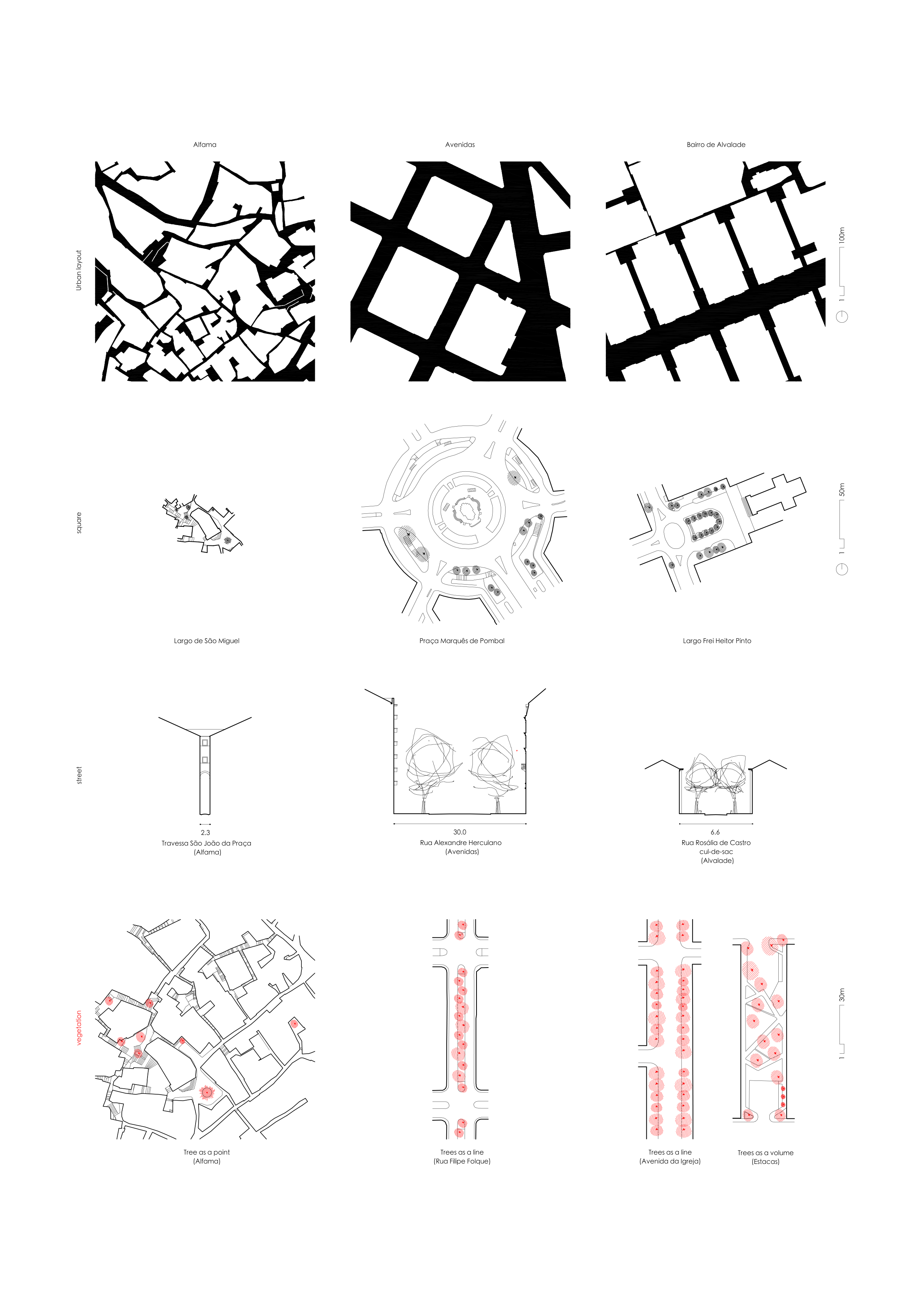
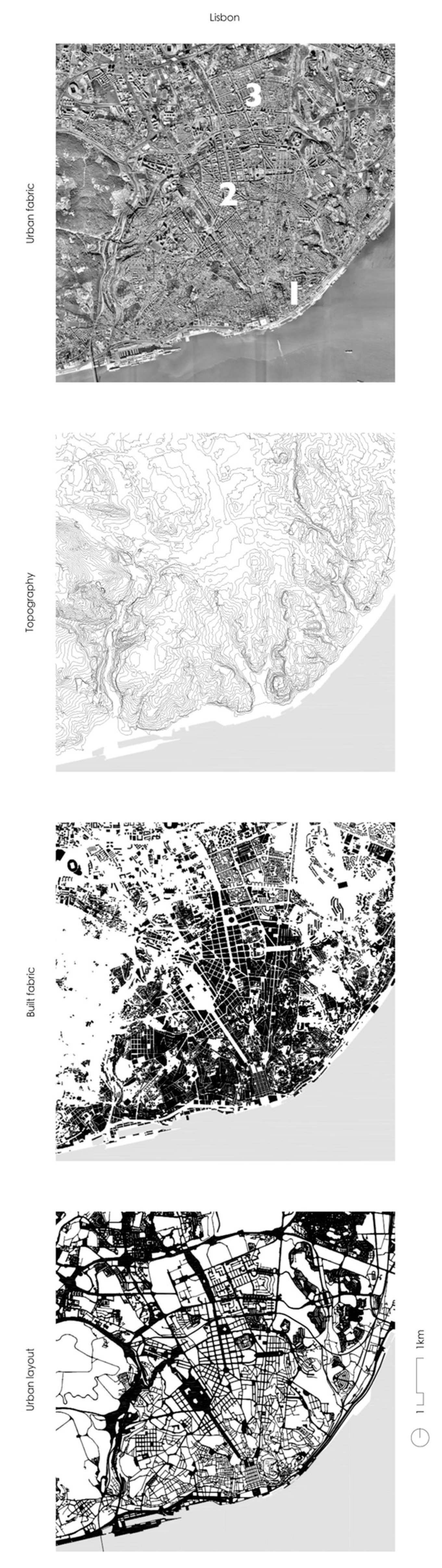
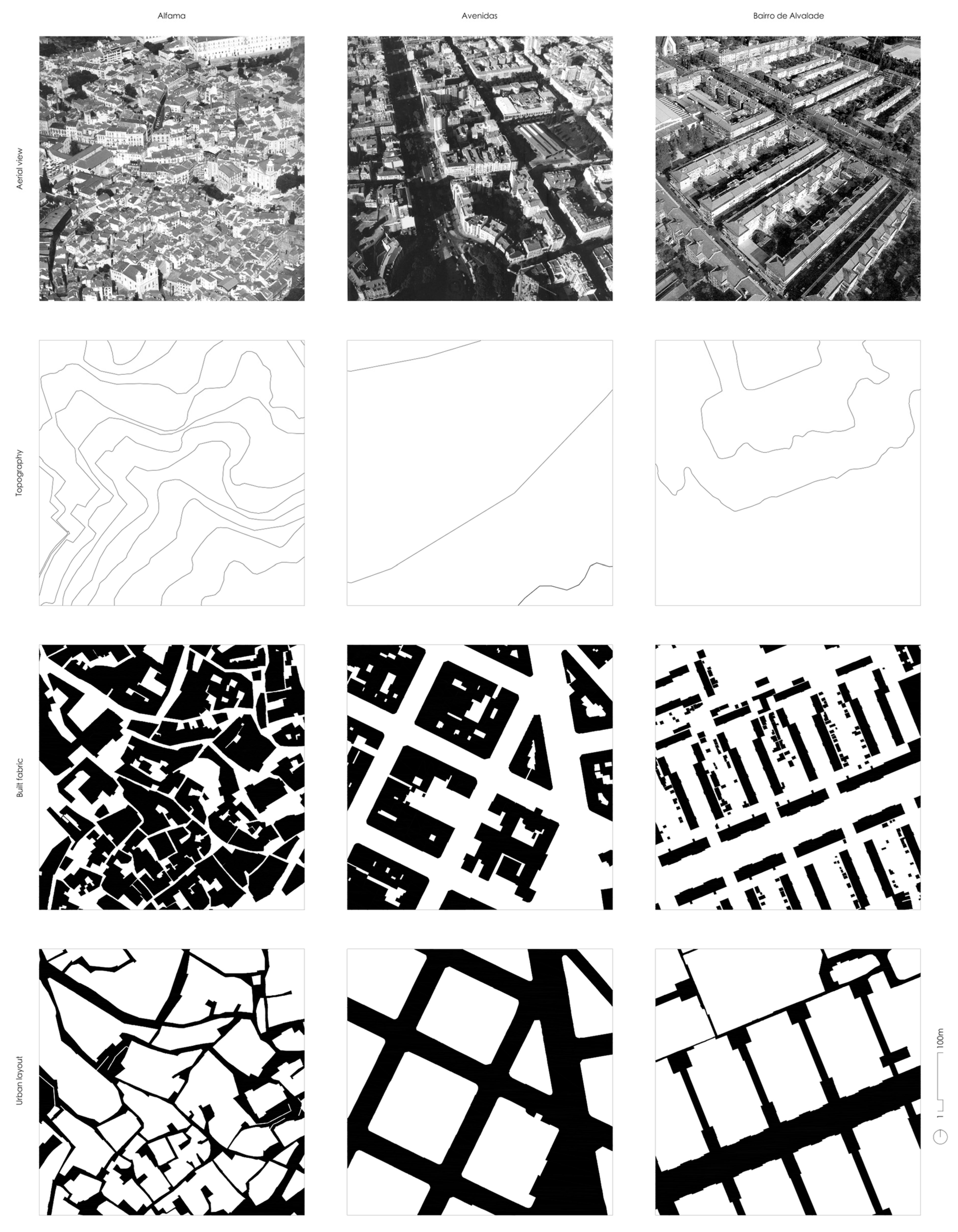
In Lisbon (
Figure 1), the heterogeneous nature of urban space is the result of formal characteristics that are representative of the intersection of different eras and peoples, contextualized by its privileged situation in the territory. Lisbon has always profited from its strategic positioning, essentially given by the navigability and natural harbour conditions of the Tagus Estuary, which promoted human presence and the establishment of open ports for all. The Atlantic history of the city and the landscape from which it emerged, combining the Tagus Estuary with an irregular topography dominated by a set of hills and valleys, determined the medieval occupation of Lisbon. This occupation developed from a dual need to accommodate the urban fabric to the topography whilst benefiting from a safe and flourishing port. Its history is marked by a succession of earthquakes such as the one in 1755 that forever transformed its image, creating a new identity, defining new boundaries, and further propelling the emergence of new neighbourhoods. Like other nineteenth-century European cities, avenues ripped open, expanding the city northward and along the valleys. The city’s growth would later cover all directions, driven by the twentieth-century demographic boom, which justified the emergence of new developments.
In Lisbon, the tension between diversity and unity is evident due the existence of urban fabrics that has undergone long processes of sedimentation (Alfama), urban fabrics that result mainly from an idea of urban production based on the conception of public space (Avenidas), others designed as an integral unit (Alvalade), operations which reject the classic elements of urban composition such as the street and block (Olivais), or more recent urban fabrics representing the recovery of these elements in city urban composition (Parque das Nações). All of these emerged between different development phases of the city and among different natural land morphologies such as hills, valleys and the riverfront (
Figure 2). The combination of urban fabrics in the city not only translates into its formal complexity, but also into the dialogue between its public form and the presence of trees (
Figure 3).
In Lisbon, the presence of trees is significant and varied but was largely confined to the private courtyards within the urban blocks until the nineteenth century. At this time, the presence of arboreal elements in the public structure was meticulous, punctuating spaces of a more singular nature, as can still be observed in Alfama.
It was not until the mid-nineteenth century that trees began to play a truly essential role in the qualification and beautification of the city, especially in exceptional public spaces such as belvederes, squares or gardens, but also in streets of larger sections. This idea was supported by hygienist principles that favoured the healthiness of urban space, envisioned as broad, airy and with the presence of vegetation. This tendency quickly became a rule for both new and pre-existing spaces, in a logic that also became a hierarchy of the urban structure of the city [
13].
The present form of the city clearly expresses this evolutionary process that we will here aim to synthesize by focusing on the analysis of different areas of Lisbon. The three chosen areas to be explored—Alfama, Avenidas and Alvalade—are sufficiently distinct in their form and context, allowing a comparative interpretation of the differences between their main morphological elements. Because of their historical and/or landscape context, each homogeneous area now presents a distinct physical structure with diverse urban functions and human activities. Furthermore, it is possible to recognize how different vegetation is composed and how the presence of vegetation influences the acknowledgement of the particular urban morphology of each area and of the city as a whole.
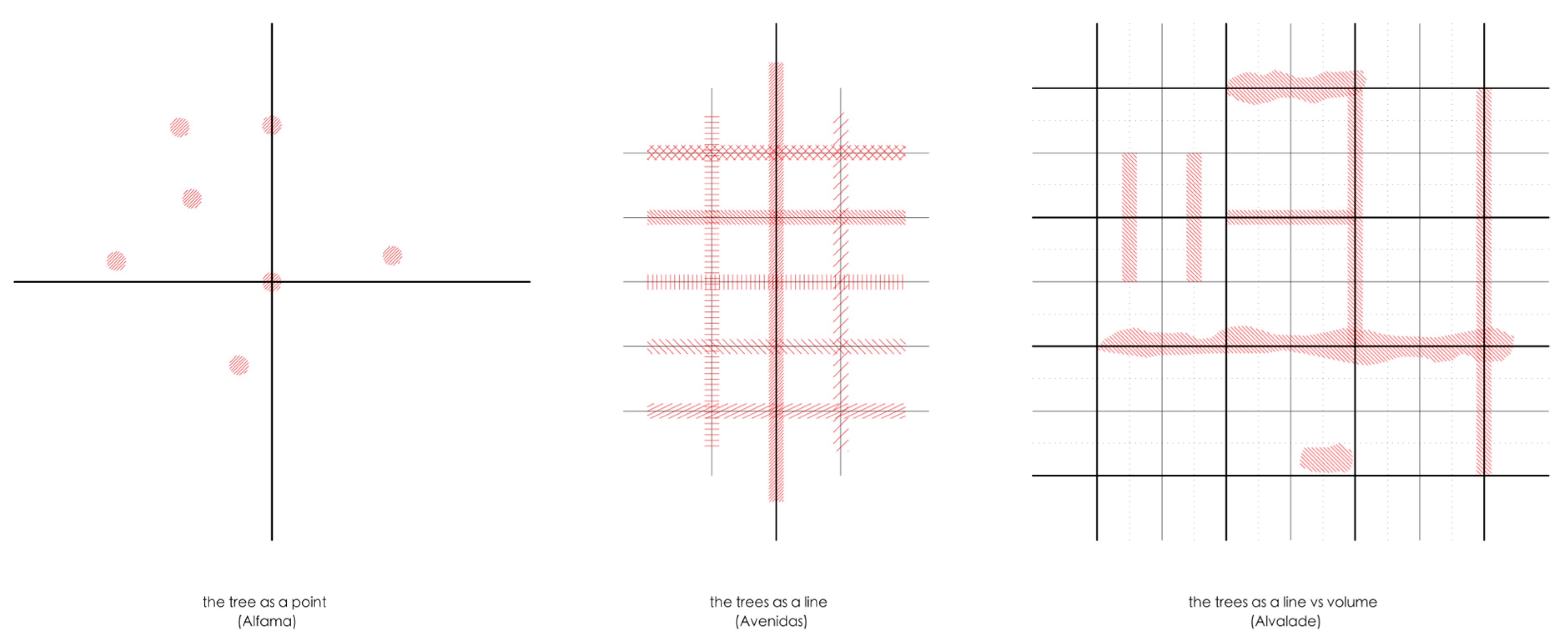
3.1. Alfama—the Tree as a Point
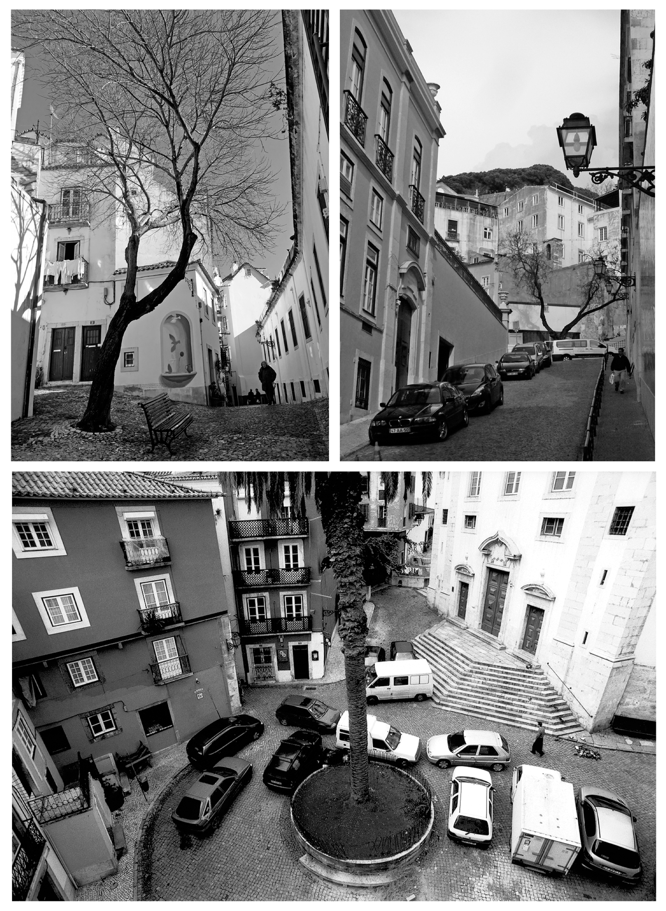
The urban fabric of Alfama corresponds to what remains of the old medieval nucleus of the city of Lisbon. This nucleus, also formed by the Baixa and Mouraria neighbourhoods, was until the 1755 earthquake circumscribed to the area within the Fernandina Wall. Alfama thus presents itself as a singular segment of this urban reality, representative of a way of producing the city that results from a gradual and organic process of urban fabric formation and transformation. In other words, it is the physical inheritance of the tension between different individual actions, desires and needs over time.
Developed in a clear adaptation to the topography, the urban fabric results in a composition where private and public spaces are easily recognizable and well defined. This means that urban blocks are defined by the urban layout and, at the same time, they define the boundary and alignment of streets, being densely occupied by housing buildings and occasionally containing gardens and open spaces inside.
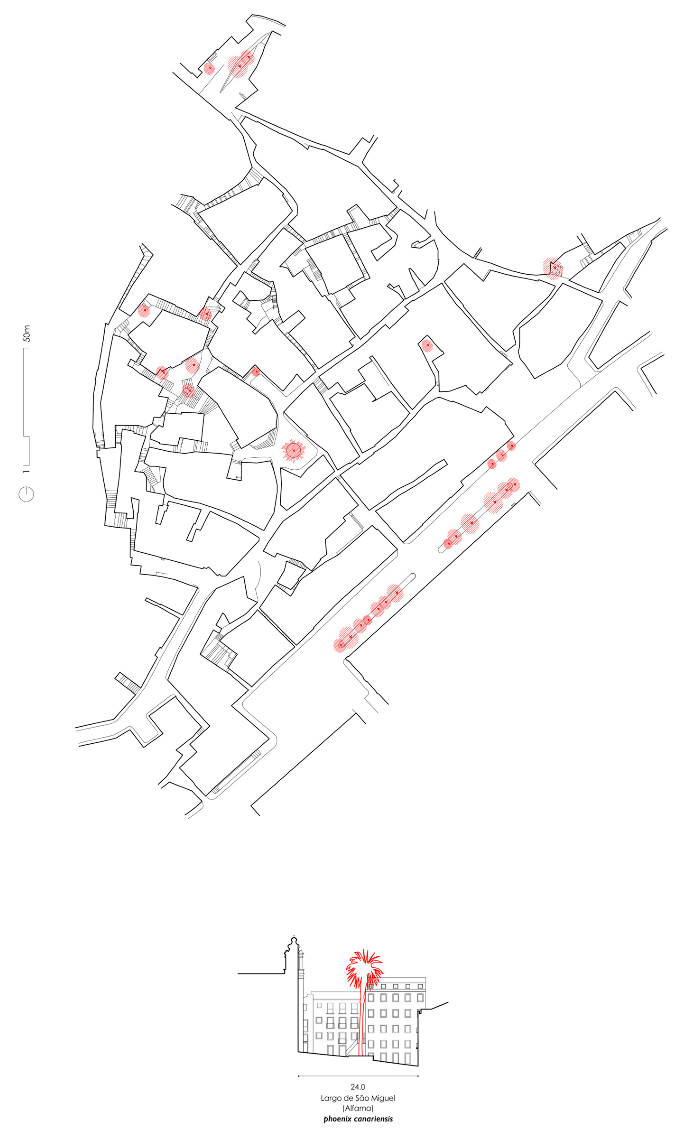
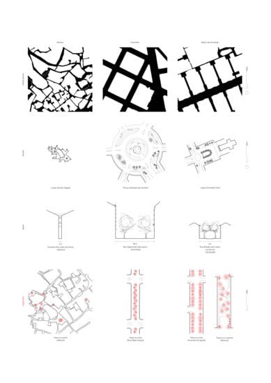
The type of urban organization is the result of a way of developing the city that starts from the design of the street, where the urban block is the remaining element in the composition. The urban layout of Alfama is composed of a set of formal and toponymical diverse spaces: streets, alleys, stairways and arches. The structure that integrates them (
Figure 4, above) develops mainly from two design logics, one that presupposes a desire to connect the river to the highest point of the slope in the most efficient way, and another, which perceives the singular elements, spaces and buildings, as fabric generators influencing the definition of their form and hierarchy.
Existing planted vegetation is scarce and encompasses mostly trees, such as
Phoenix canariensis, Tipuana tipo or
Celtis australis, taking form in sporadic positionings and mainly with a single tree element (
Figure 5). Bearing in mind the topography of the place and the stature and volume that these trees may reach, they often constitute landmarks, contributing to orientation and location through their singularity. That is namely the case of the
Phoenix canariensis that used to be at Largo de São Miguel (
Figure 4, below), which died from a palm tree scarab (
Rhynchophorus ferrugineus) but has been recently replaced with a younger specimen. This sporadic presence of isolated trees in the Alfama structure is also associated with secondary spaces such as bystreets, stairs or even in alleys.
There is also a great density of greenery in pots of various configurations and vegetation of different species that residents place at their front doors or windows, stairs or courtyards, appropriating public space. In some situations, it is possible to find climbing or suspended vegetation that partially covers handrails, arcades or buildings.
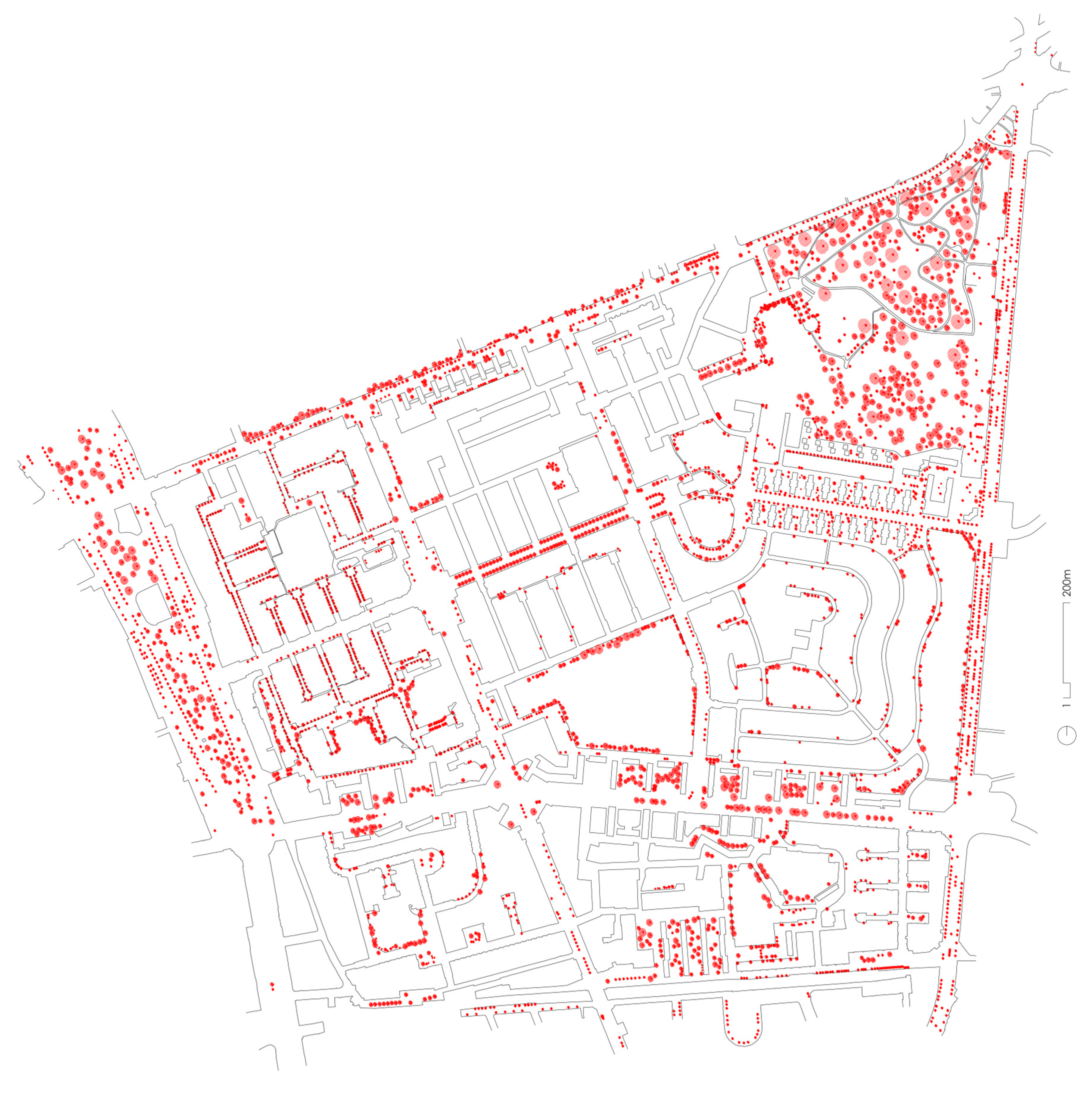
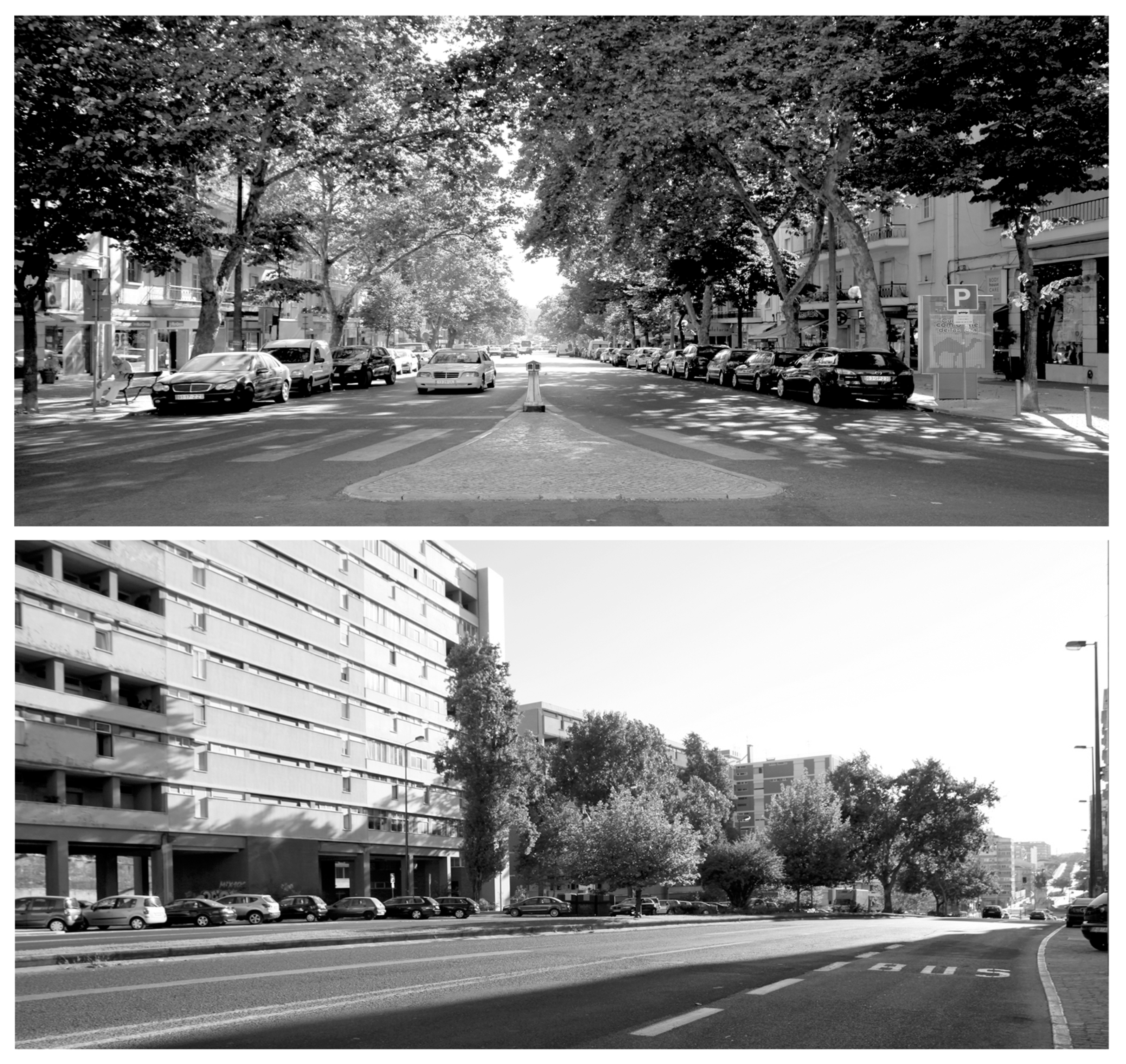
3.2. Avenidas—the Trees as a Line
The Avenidas is one of the richest urban and architectural environments of Lisbon, not so much by the representativeness of its buildings, but mainly due to an eclectic assortment of types and styles formed since the late nineteenth century by the Avenidas plan. Designed by Ressano Garcia, the plan led the development of the city to the north, using an elementary urban system composed of an orthogonal design matrix similar to what happened in other European cities of the nineteenth century. It clearly appears in response to the emergence of a new bourgeois class claiming a habitable, spacious and airy city with green spaces.
The plan is based on a juxtaposed structure of three different urban layouts organized around three central axis sequentially articulated along the valleys by squares. In addition, the proposal structure includes the integration of a set of pre-existing elements: some rural plots, buildings and, above all, a primary structure of roads connecting the city with the small rural nucleus beyond Lisbon [
17].
The plan composition encompassed two opposite approaches when considering, on the one hand, the detail given to the design of public space and, on the other hand, significant uncertainty about private space by the absence of architectural regulations for buildings. These guiding principles, or the lack of them, have remained until the present day, forming an urban unit where public space remains practically untouched and the built fabric lives in constant transformation. In a built fabric formed mainly by housing typologies of different configurations, a new trend appeared from the 1970s onward to integrate services and commercial buildings into the main axes of the Avenidas. This process reinforces a tendency to concentrate human activities in the squares that articulate them.
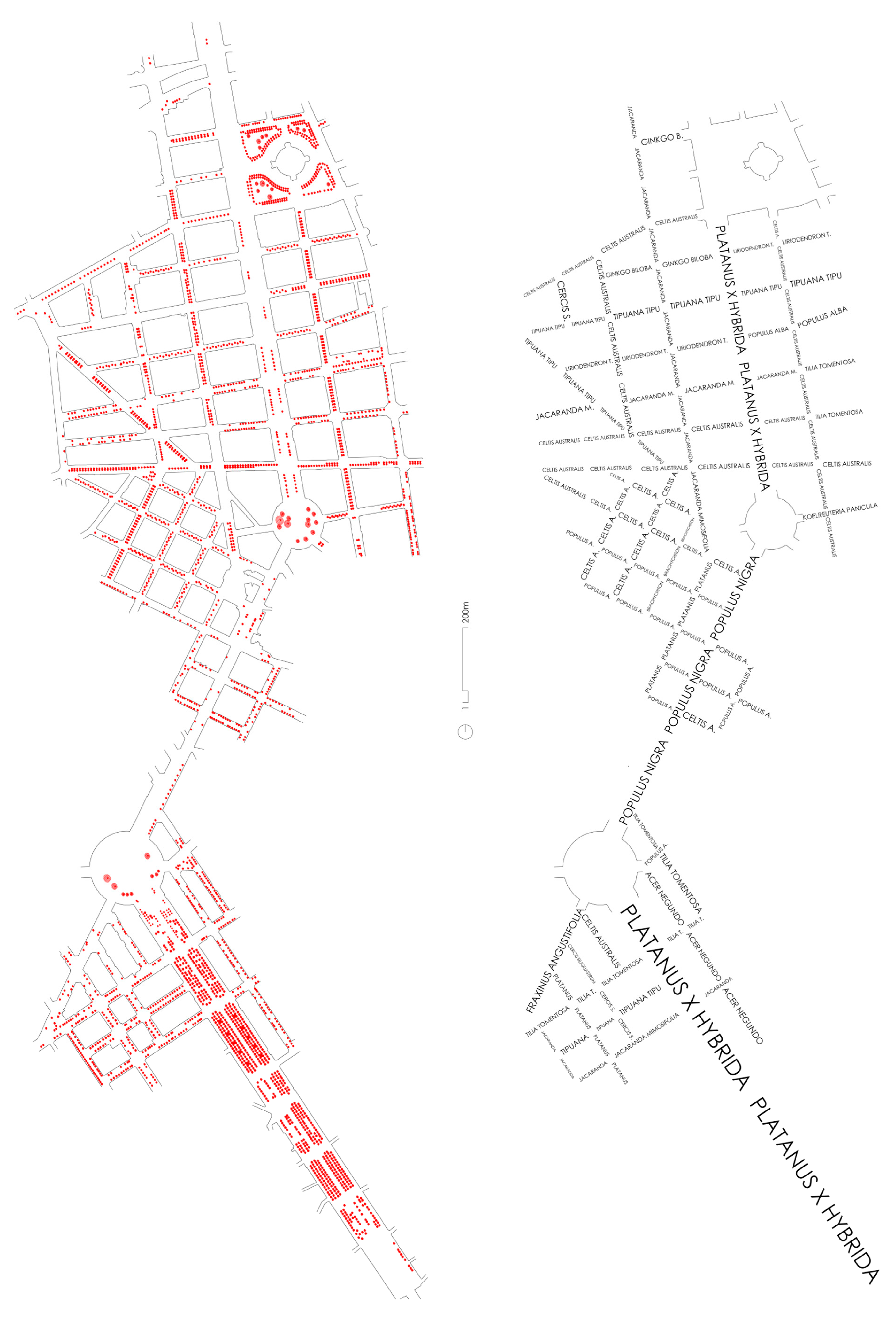
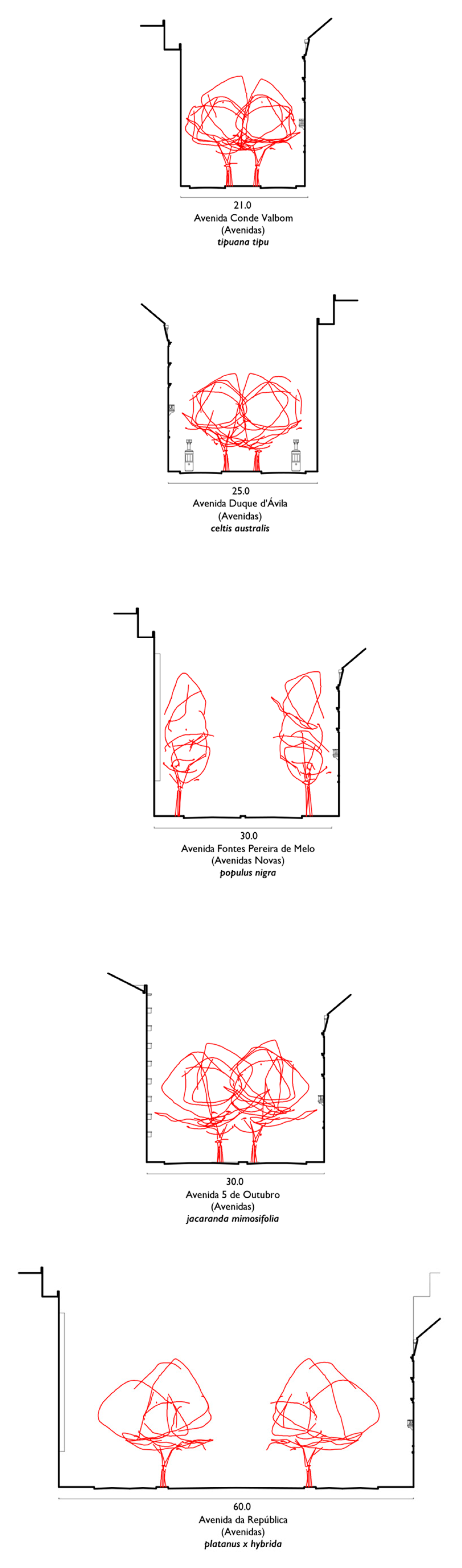
In the genesis of the plan for Avenidas, Ressano Garcia and António Maria Avellar had the intention of planting different tree species in each avenue—
Platanus x hybrida for Avenida da República,
Jacaranda mimosifolia for Avenida 5 de Outubro,
Celtis australis for Avenida Duque d’Ávila,
Tipuana tipu for Avenida Conde Valbom,
Populus tremula for Avenida Fontes Pereira de Melo, amongst others (
Figure 6, right;
Figure 7). This characteristic, that is still evident today, gives a singular character to each street, “the trees created the initial identity of the street” [
13].
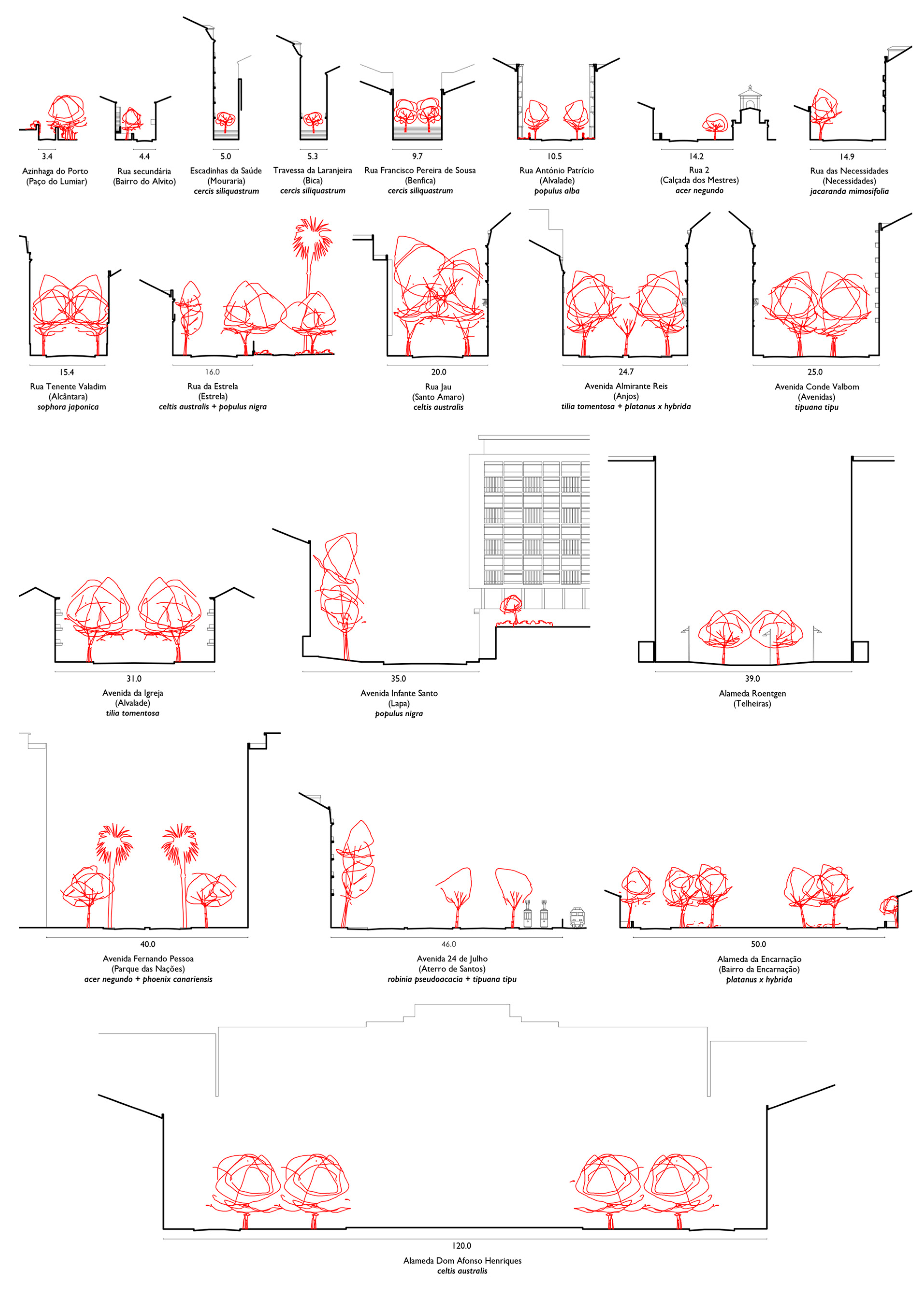
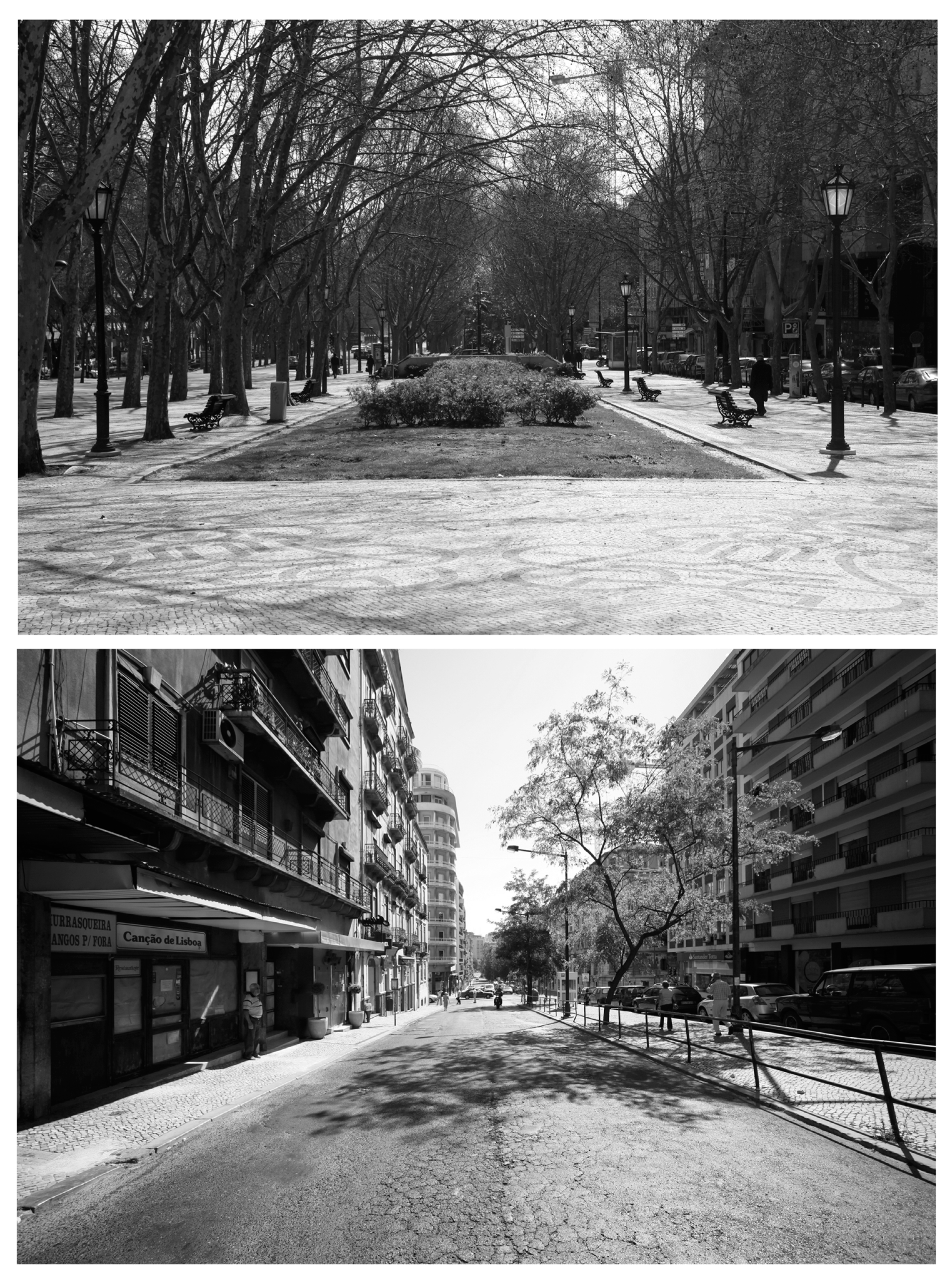
Plantations in this urban structure are mostly linear, emphasizing the rectilinear tracings of the different avenues (
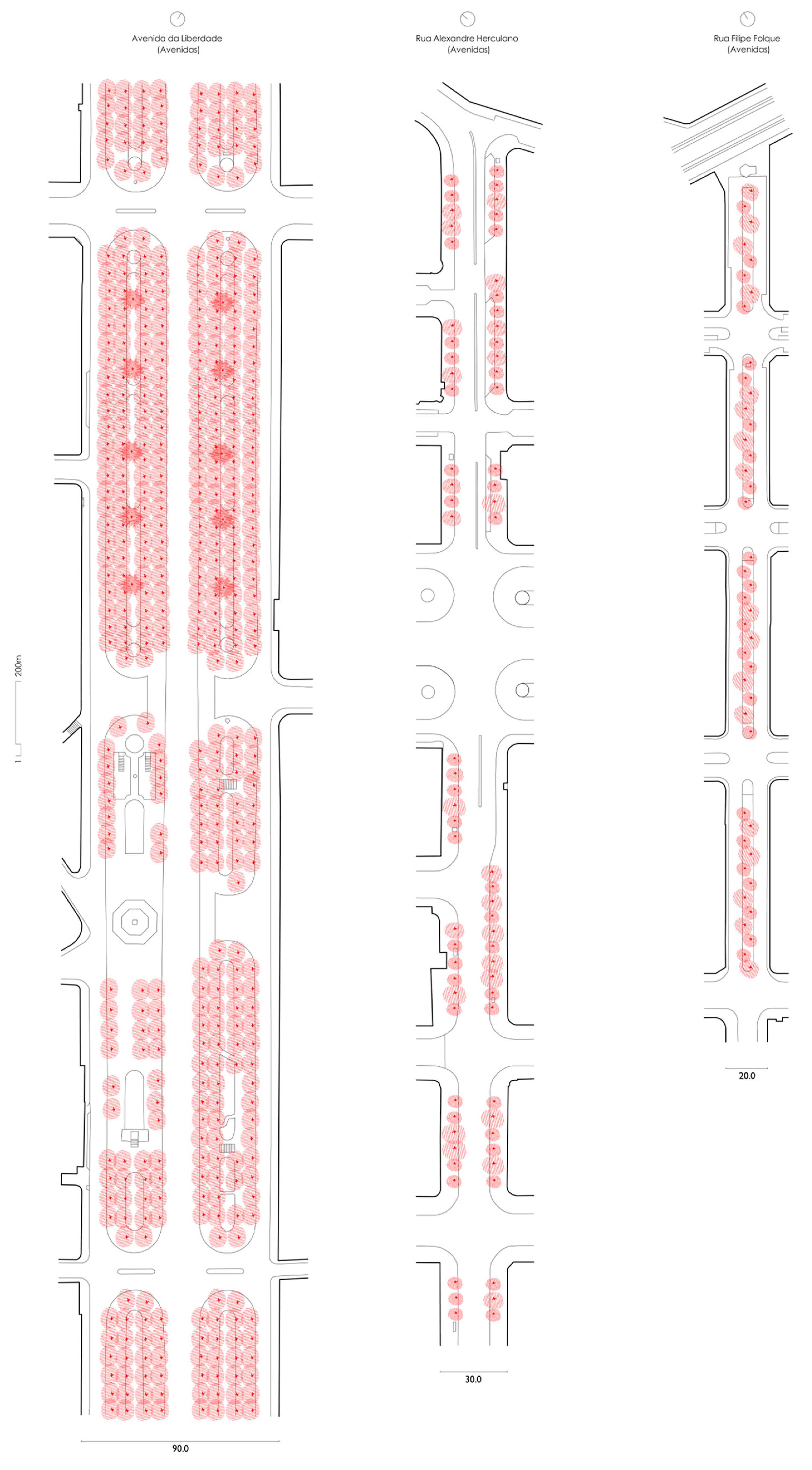
Figure 6, left). These linear structures, formed by the orderly distribution of trees along an axis, constitute alignments that develop parallel to the building that forms the street. Alignments allow the delimitation, separation and framing of elements and spaces that form the street cross-section, depending on their position. Usually, the alignments we find in the city of Lisbon are formed by two parallel lines of trees that are positioned on the sides of the street, separating the road from the pedestrian. This principle is mainly verified in the streets created between the late nineteenth and early twentieth centuries, yet we often find variations of streets with central alignments.
The case of Avenidas is a good example where the presence of these two types of alignments—lateral and central—is recurrent and balanced, such as the Alexandre Herculano and Filipe Folque streets (
Figure 8). These two examples also allow the demonstration of different ways of forming these alignments, evidencing the existence of single lines and lines that can be multiplied within the same street space (
Figure 9), usually composed of trees of the same species. Exceptionally, these alignments derive from tree line aggregations of different species, such as the case of Avenida da Liberdade (
Figure 8), highlighting the structuring role of this street space in the context in which it is inserted. This example highlights the importance that alignments can have in the definition of a hierarchical urban structure, such as the case of Avenidas.
3.3. Alvalade—the Trees as a Line vs. the Trees as a Volume
At a time when the housing issue was sensitive, given the social changes caused by World War II that changed the urban reality of the city, the Alvalade neighbourhood, designed by Faria da Costa in 1944, proved to be experimental and innovative in the way it was conceived and then executed. The urban plan was promoted by the municipality, integrated in one of the biggest transformation areas north of Lisbon already planned in the Master Plan of Étienne de Groer (1938–1948).
The implementation of the urbanization plan for the area south of Avenida Alferes Malheiro was managed and partially assured by the State, thus defining specific areas for private construction. This situation favoured not only the introduction of the neighbourhood unity principle, but also the coexistence of different typologies of social housing with significant variations in building and public space design, as the current urban fabric still reproduces [
18]. Therefore, the design of the Alvalade neighbourhood results from an articulated and rich set of ideas of urban fabric production where the urban layout, plot structure and building are an integral part of the design. If we consider the principles governing the execution plan, we can easily observe that they remain in the current structure of the neighbourhood: the nature, form and hierarchy of the urban layout; the eight housing cells and the road organization of each one of them; the exceptional elements that serve as articulation and focus of the urban layout; central public spaces in each housing cell, associated with school equipment and green spaces; the preponderance and diversity of the housing typology; and the coexistence of different urban models and experiences [
18] (
Figure 8).
The Alvalade neighbourhood is today a qualified space and a reference of diverse urban environments in the context of the city of Lisbon. We can, therefore, find spaces of great intensity of flows and activities, located along the main axes, as well as spaces whose vocation is almost exclusive of access to the dwellings and, therefore, of smaller flow.
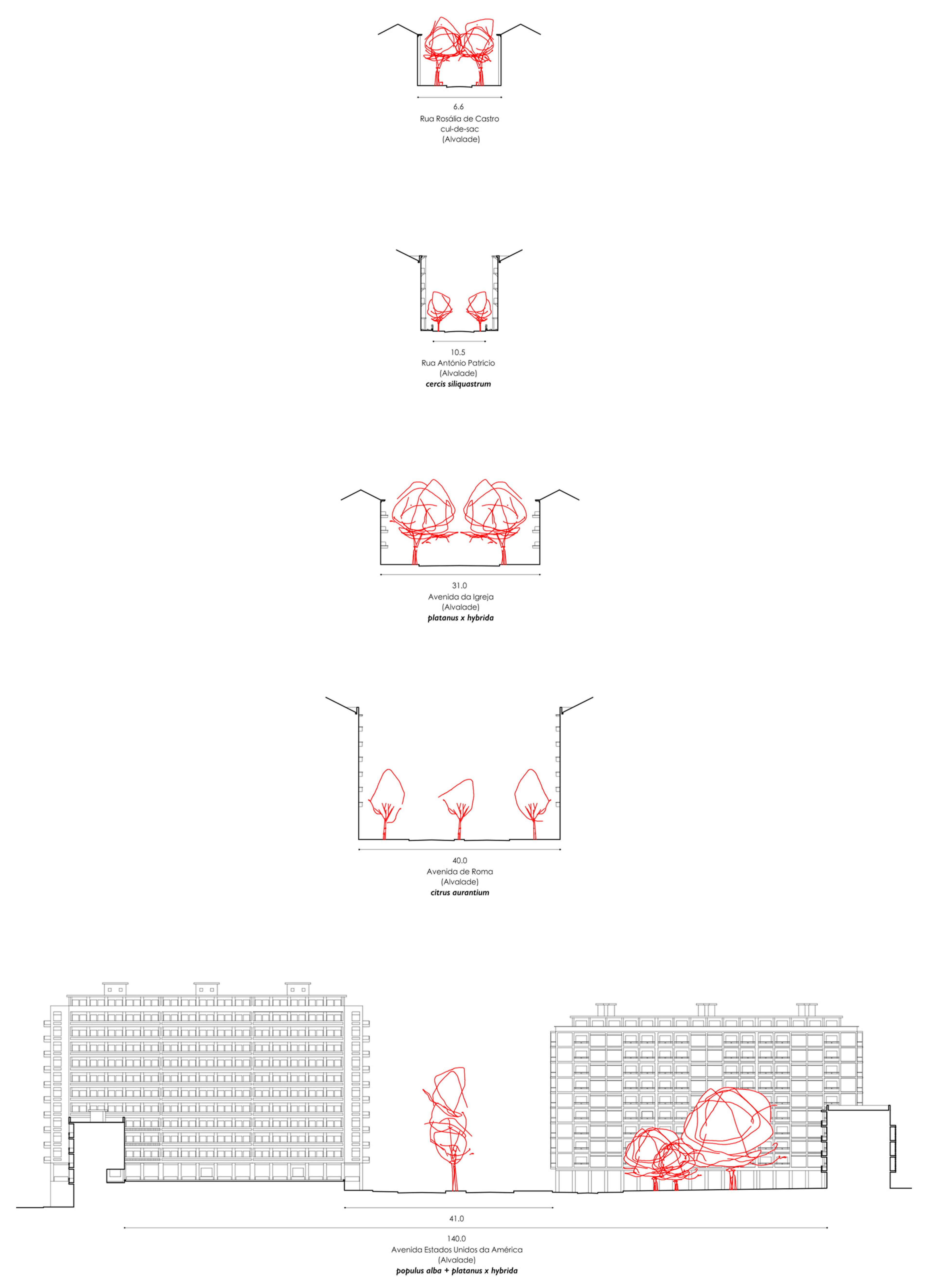
In accordance with the ideals planned for this area, vegetation is highly present and takes form in various ways (
Figure 10 and
Figure 11). Indeed, several effects are combined through tree and shrub alignments as well as occasional volumes of dense irregular vegetation to provide not only a distinctive place with its own identity but also a place of proximity.
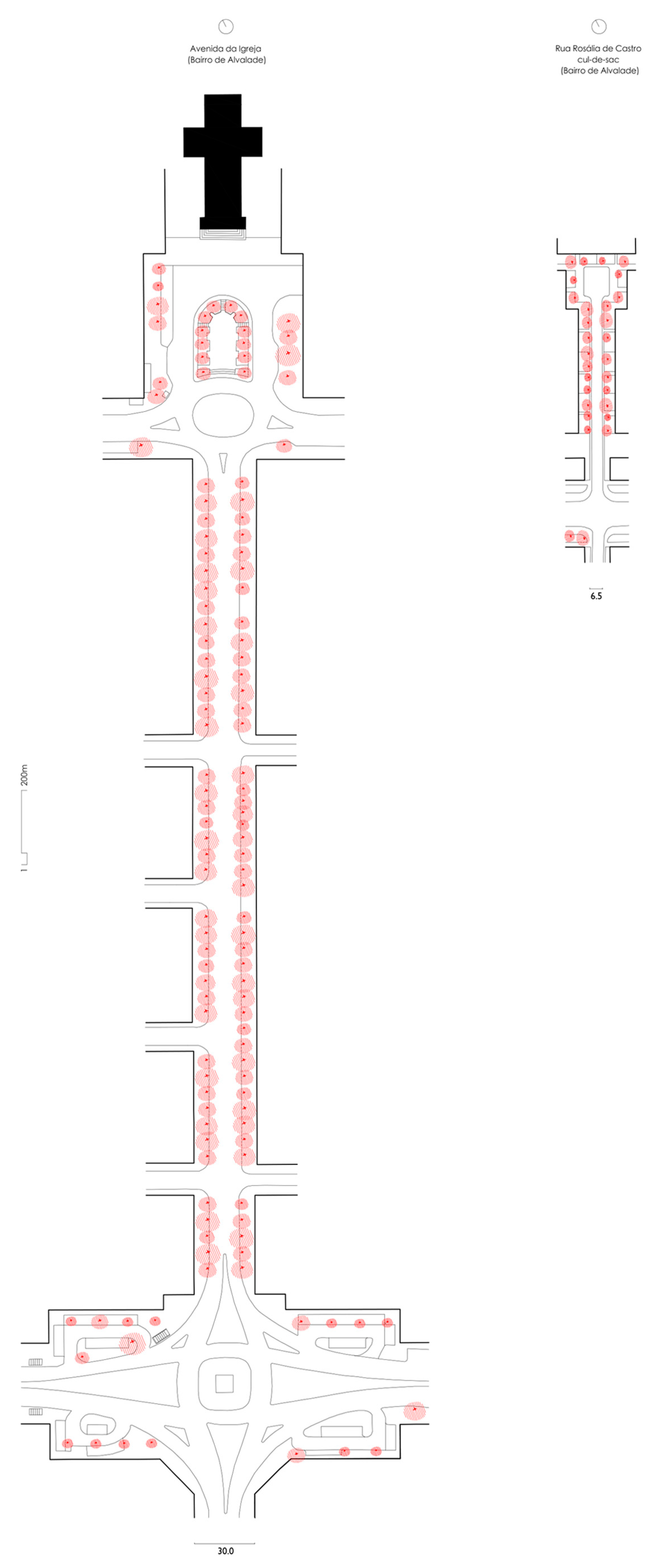
One may note tree alignments, generally arranged for staging, emphasizing and framing a monument. That is namely the case of the alignments in Avenida da Igreja, developed in two parallel lines of trees (
Figure 12, left). This alignment is reinforced by the presence of four
Cupressus semprevirens in front of the church of São João de Brito. In other situations, namely in the “cul-de-sac” areas structured in “U’s”, vegetation is prominent (
Figure 12, right). In these areas, tree alignments are combined with flower beds with all kinds of vegetation from shrubs to herbaceous and climbing plants. In this former situation, vegetation sets the boundaries of space, consolidating an urban identity through its textures. This example emphasizes that tree alignments are not always associated with streets of higher hierarchy. Indeed, in the case of Alvalade, tree alignments are identified in both structuring streets and housing impasses.
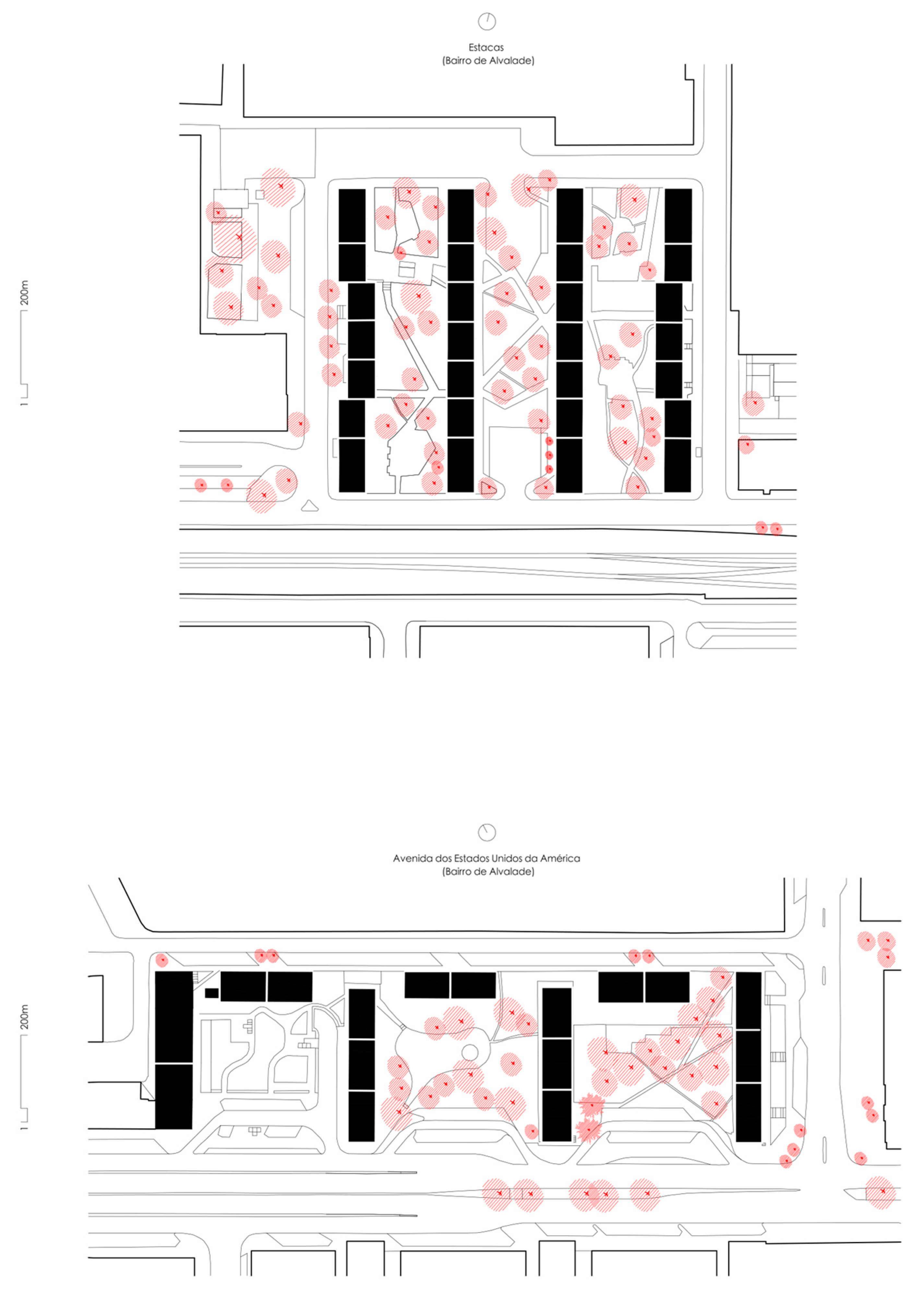
On the other hand, in the same neighbourhood, it is possible to identify aggregations of trees that adopt different languages, due to their more informal emplacements. In these cases, the trees are combined and arranged more organically and are often of distinct species, forming a dense green volume. In Alvalade, Bairro das Estacas and Avenida EUA (
Figure 13), they assume a pioneering role in the city of Lisbon, as, amongst others, they are the first spaces that encompassed plantations of these characteristics, designed during the 1950s [
19]. Today, it is possible to find other spaces in Alvalade of a more exceptional nature that adopt this system of trees aggregation in relatively dense volumes.
Diversity may be the best word to describe Alvalade, not only in the multiple experiences of aggregation of built typologies but also of tree aggregation, of which the different tree alignments and the large green volumes of trees that fill the space between the buildings stand out unequivocally (
Figure 14).
4. Conclusions: Vegetation as an Element of Urban Morphology
In the medieval morphology of Alfama, trees are scarce and appear in sporadic positionings. Most of these trees, individually, constitute landmarks. In some situations, groups of trees form protecting domes constituting semi-enclosed spaces and generally, throughout the homogeneous area, gatherings of vegetation in different types of pots adjoining the public space form part of the collective landscape. In the post-industrial Avenidas designed by Ressano Garcia, tree alignments are the dominant vegetation form, emphasizing the proposed rectilinear tracings. In some situations, the volume resulting from these alignments competes with the height of adjacent buildings. Finally, in the modern Alvalade neighbourhood, vegetation is highly present. It encompasses the combination of vegetation alignments with occasional volumes of dense and irregular vegetation. In some situations, regular tree and shrub alignments serve staging purposes. In other situations, trees and shrubs rather serve as borders that confine and consolidate privileged spaces.
In this study, the main characteristics of the urban structure are revealed, together with the importance of vegetation as an element of urban morphology (
Figure 15), which significantly contributes to the understanding and interpretation of the city. If other homogeneous areas were analysed, new urban morphological components would very likely be identified.
Most importantly, this initial systematization process serves to improve knowledge on the reading of urban greenery, also offering another set of values for contemporary design processes. Indeed, the use of morphological analysis as an analytical methodology is both an exploratory tool to understand existing urban, architectural and vegetation forms, and a tool for the creation of new forms. In this sense, the urban morphology exercise gains relevance in architectural and landscape architectural education, providing tools to improve the process of creative research and design. Overall, these outputs, methodology and theoretical framework aim to contribute support to a design process that can respond to the challenges of the contemporary city and improve human well-being through the acknowledgement of vegetation as a contributor to the creation of specific, unique and unrepeatable spaces within urban landscapes.

