Designing a Blue-Green Infrastructure (BGI) Network: Toward Water-Sensitive Urban Growth Planning in Dhaka, Bangladesh


Abstract
1. Introduction
2. Literature Review
2.1. Understanding Blue-Green Infrastructure (BGI) and Current Trends
“a strategically planned network of natural and semi-natural areas with other environmental features designed and managed to deliver a wide range of ecosystem services. It incorporates green spaces (or blue if aquatic ecosystems are concerned) and other physical features in terrestrial (including coastal) and marine areas. On land, green infrastructure is present in rural and urban settings.”[34]
“an interconnected network of natural and designed landscape components, including water bodies and green and open spaces, which provide multiple functions such as: (i) flood control, (ii) water storage for irrigation and industry use, (iii) wetland areas for wildlife habitat or water purification, among many others.”[40] (p. 499)
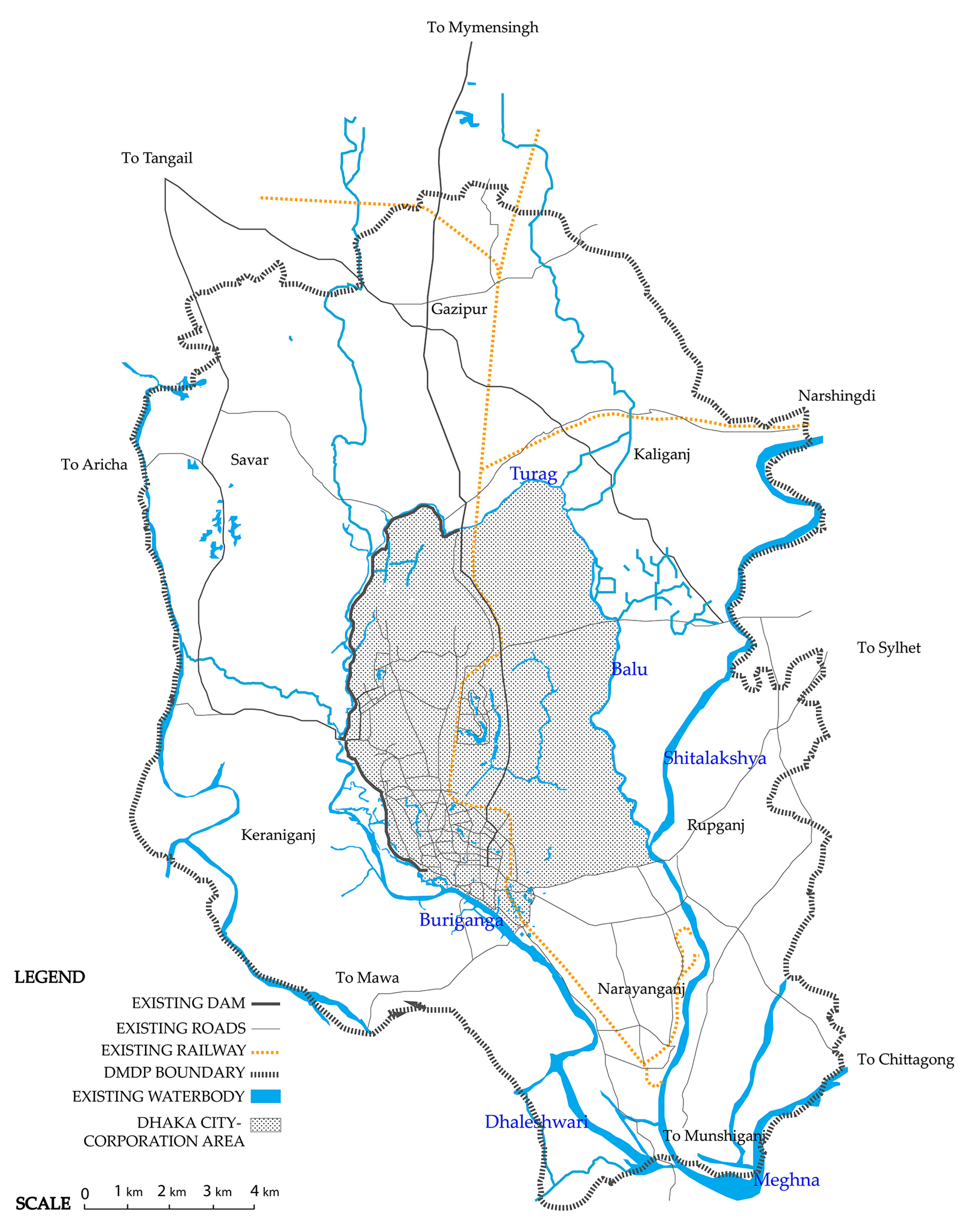
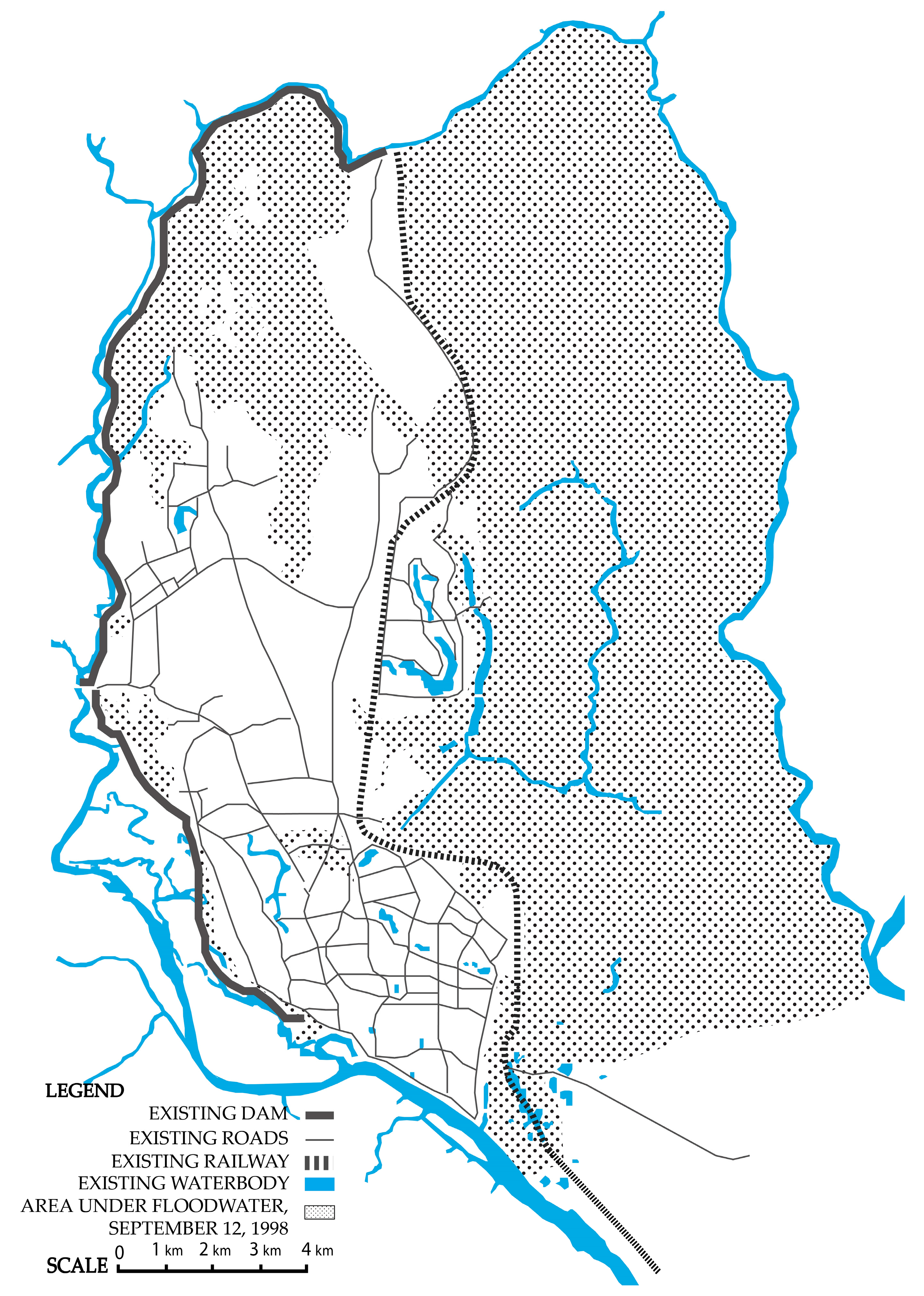
2.2. Context: Water and Dhaka’s Urbanization
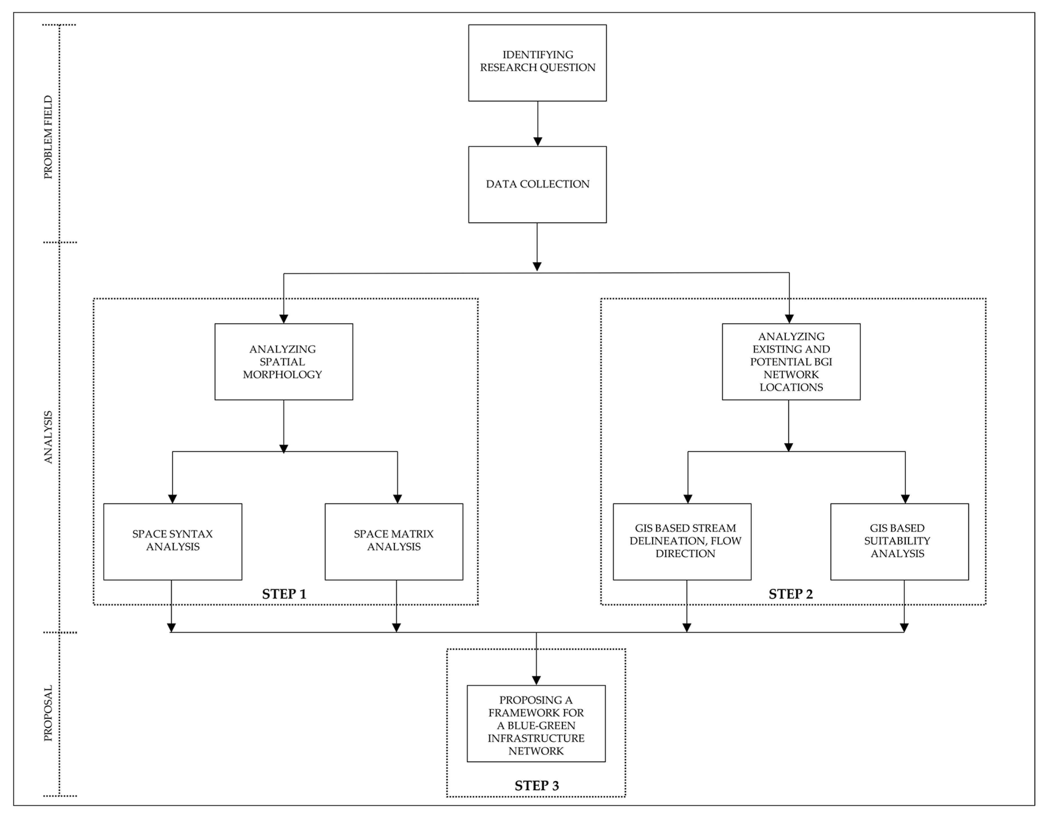
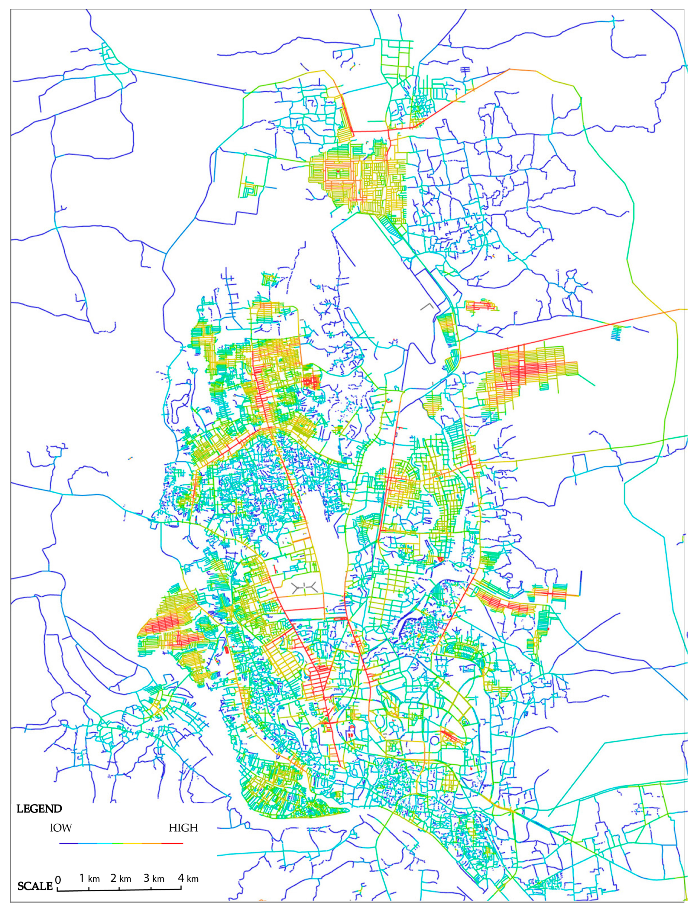
3. Materials and Methods
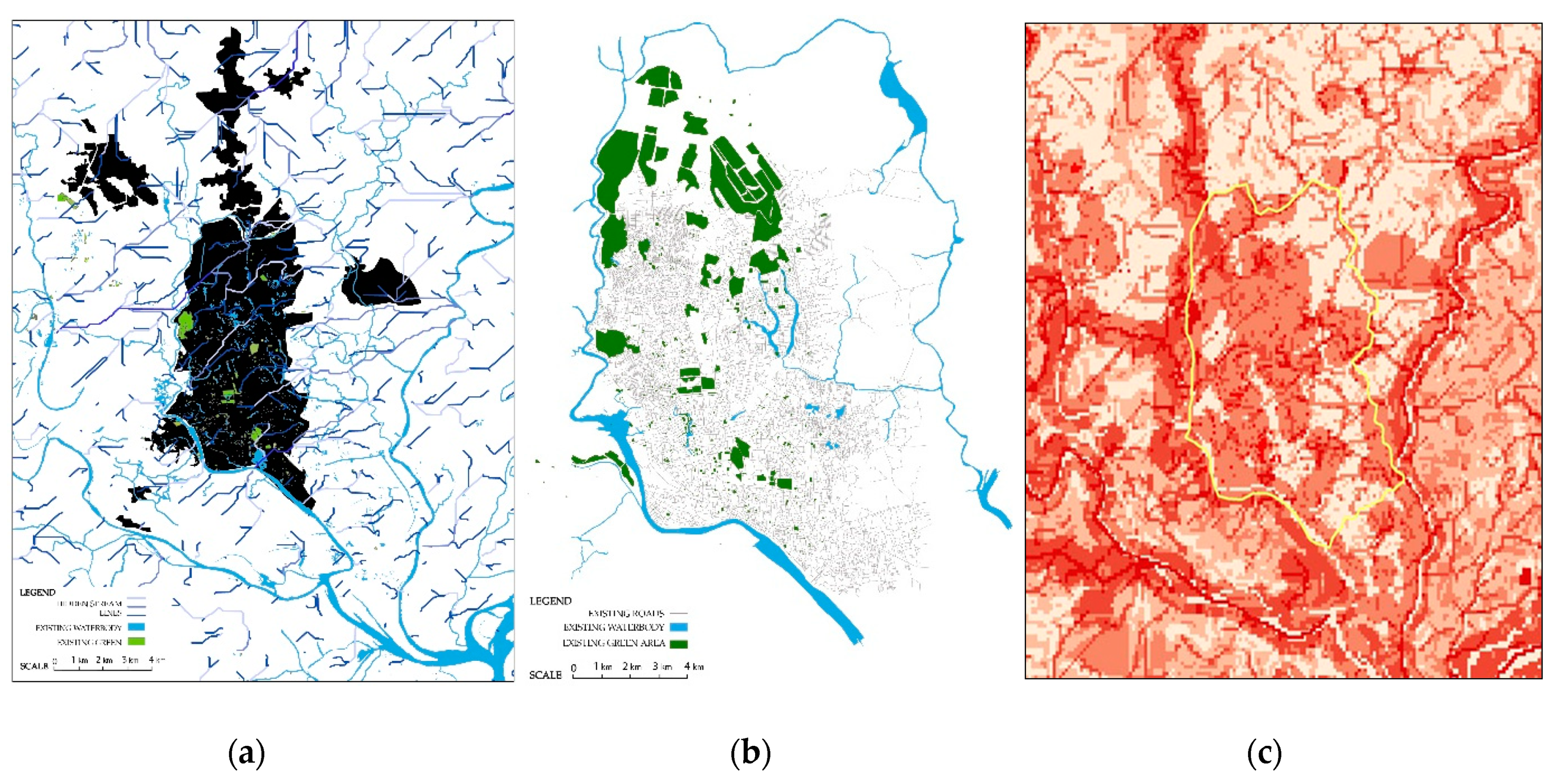
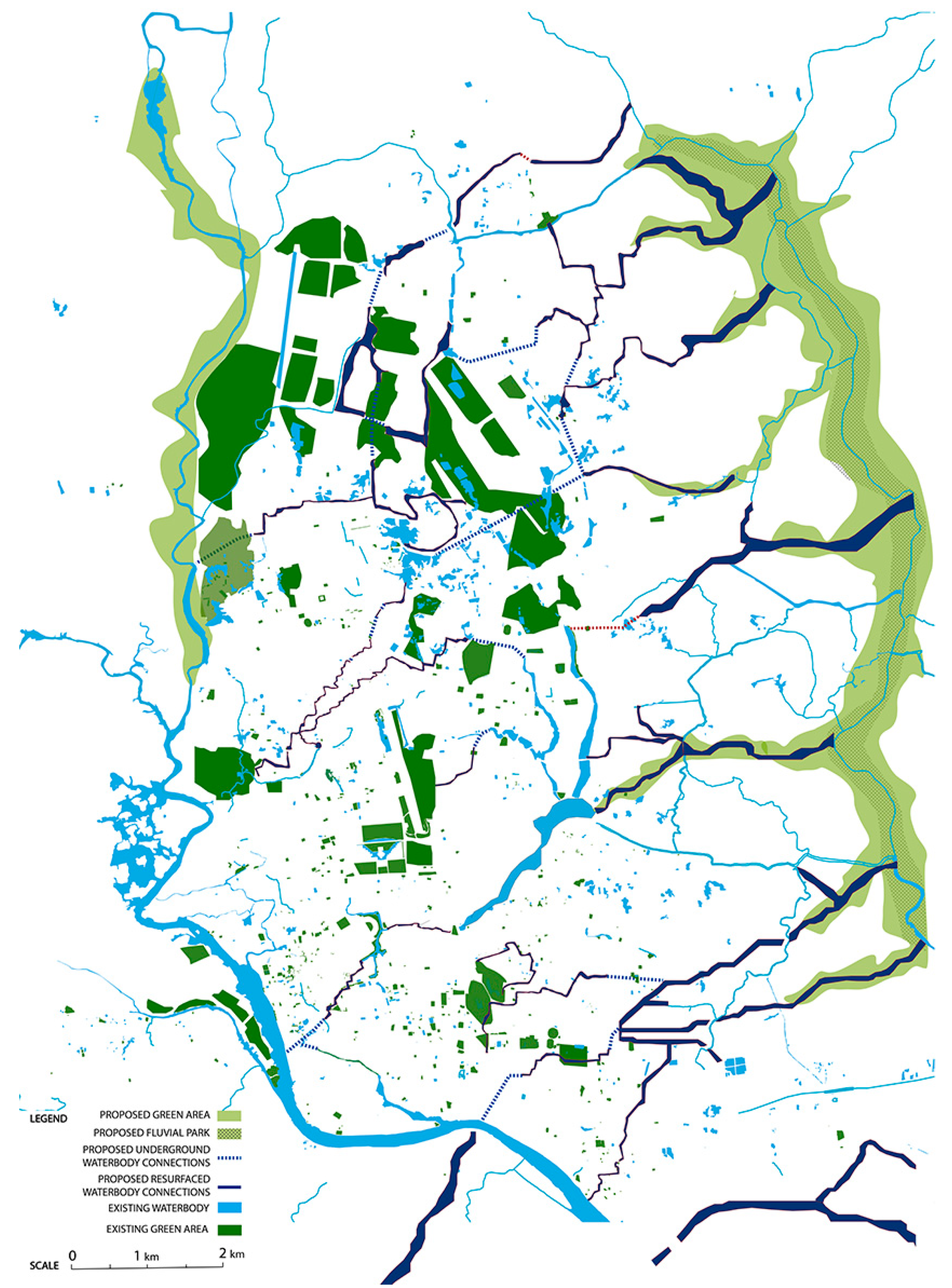
4. Results and Recommendations
5. Discussion
6. Conclusions
Author Contributions
Funding
Acknowledgments
Conflicts of Interest
References
- Wong, T.H.; Brown, R.R. The water sensitive city: Principles for practice. Water Sci. Technol. 2009, 60, 673–682. [Google Scholar] [CrossRef] [PubMed]
- OECD. Water Governance in Cities; OECD Publishing: Paris, France, 2016. [Google Scholar]
- Varis, O.; Biswas, A.K.; Tortajada, C.; Lundqvist, J. Megacities and water management. Water Resour. Dev. 2006, 22, 377–394. [Google Scholar] [CrossRef]
- Ahmed, S.; Meenar, M. Just Sustainability in the Global South: A Case Study of the Megacity of Dhaka. J. Dev. Soc. 2018, 34, 401–424. [Google Scholar] [CrossRef]
- Kraas, F.; Mertins, G. Megacities and global change. In Megacities; Springer: Berlin, Germany, 2014; pp. 1–6. [Google Scholar]
- Kim, J.H.; Keane, T.D.; Bernard, E.A. Fragmented local governance and water resource management outcomes. J. Environ. Manag. 2015, 150, 378–386. [Google Scholar] [CrossRef] [PubMed]
- Centre for Research on the Epidemiology of Disasters-United Nations Office for Disaster Risk Reduction (CRED-UNISDR). The Human Cost of Weather-Related Disasters 1995–2015; Centre for Research on the Epidemiology of Disasters (CRED): Brussels, Belgium; United Nations Office for Disaster Risk Reduction (UNISDR): Geneva, Switzerland, 2015. [Google Scholar]
- Guha-Sapir, D.; Vos, F.; Below, R.; Ponserre, S. Annual Disaster Statistical Review 2011: The Numbers and Trends; Centre for Research on the Epidemiology of Disasters (CRED): Brussels, Belgium, 2012. [Google Scholar]
- Cousins, J.J. Infrastructure and institutions: Stakeholder perspectives of stormwater governance in Chicago. Cities 2017, 66, 44–52. [Google Scholar] [CrossRef]
- Meenar, M.; Fromuth, R.; Soro, M. Planning for watershed-wide flood-mitigation and stormwater management using an environmental justice framework. Environ. Pract. 2018, 20, 55–67. [Google Scholar] [CrossRef]
- Petit-Boix, A.; Sevigné-Itoiz, E.; Rojas-Gutierrez, L.A.; Barbassa, A.P.; Josa, A.; Rieradevall, J.; Gabarrell, X. Floods and consequential life cycle assessment: Integrating flood damage into the environmental assessment of stormwater Best Management Practices. J. Clean. Prod. 2017, 162, 601–608. [Google Scholar] [CrossRef]
- Dhakal, K.P.; Chevalier, L.R. Urban stormwater governance: The need for a paradigm shift. Environ. Manag. 2016, 57, 1112–1124. [Google Scholar] [CrossRef] [PubMed]
- Brown, R.R.; Keath, N.; Wong, T.H. Urban water management in cities: Historical, current and future regimes. Water Sci. Technol. 2009, 59, 847–855. [Google Scholar] [CrossRef]
- Fletcher, T.D.; Shuster, W.; Hunt, W.F.; Ashley, R.; Butler, D.; Arthur, S.; Trowsdale, S.; Barraud, S.; Semadeni-Davies, A.; Bertrand-Krajewski, J.-L. SUDS, LID, BMPs, WSUD and more–The evolution and application of terminology surrounding urban drainage. Urban Water J. 2015, 12, 525–542. [Google Scholar] [CrossRef]
- Mitchell, B. Integrated water resource management, institutional arrangements, and land-use planning. Environ. Plan. A 2005, 37, 1335–1352. [Google Scholar] [CrossRef]
- Gleick, P.H. Global freshwater resources: Soft-path solutions for the 21st century. Science 2003, 302, 1524–1528. [Google Scholar] [CrossRef] [PubMed]
- Pahl-Wostl, C. Requirements for adaptive water management. In Adaptive and Integrated Water Management; Springer: Berlin, Germany, 2008; pp. 1–22. [Google Scholar]
- Floyd, J.; Iaquinto, B.L.; Ison, R.; Collins, K. Managing complexity in Australian urban water governance: Transitioning Sydney to a water sensitive city. Futures 2014, 61, 1–12. [Google Scholar] [CrossRef]
- Ahiablame, L.M.; Engel, B.A.; Chaubey, I. Effectiveness of low impact development practices in two urbanized watersheds: Retrofitting with rain barrel/cistern and porous pavement. J. Environ. Manag. 2013, 119, 151–161. [Google Scholar] [CrossRef] [PubMed]
- Christman, Z.; Meenar, M.; Mandarano, L.; Hearing, K. Prioritizing suitable locations for green stormwater infrastructure based on social factors in Philadelphia. Land 2018, 7, 145. [Google Scholar] [CrossRef]
- Gogate, N.G.; Kalbar, P.P.; Raval, P.M. Assessment of stormwater management options in urban contexts using Multiple Attribute Decision-Making. J. Clean. Prod. 2017, 142, 2046–2059. [Google Scholar] [CrossRef]
- Meenar, M.R. Integrating placemaking concepts into Green Stormwater Infrastructure design in the City of Philadelphia. Environ. Pract. 2019, 21, 4–19. [Google Scholar] [CrossRef]
- Pyke, C.; Warren, M.P.; Johnson, T.; LaGro, J., Jr.; Scharfenberg, J.; Groth, P.; Freed, R.; Schroeer, W.; Main, E. Assessment of low impact development for managing stormwater with changing precipitation due to climate change. Landsc. Urban Plan. 2011, 103, 166–173. [Google Scholar] [CrossRef]
- Ellis, J.B.; Lundy, L. Implementing sustainable drainage systems for urban surface water management within the regulatory framework in England and Wales. J. Environ. Manag. 2016, 183, 630–636. [Google Scholar] [CrossRef]
- Fryd, O.; Dam, T.; Jensen, M.B. A planning framework for sustainable urban drainage systems. Water Policy 2012, 14, 865–886. [Google Scholar] [CrossRef]
- Bach, P.M.; Mccarthy, D.T.; Deletic, A. Can we model the implementation of water sensitive urban design in evolving cities? Water Sci. Technol. 2015, 71, 149–156. [Google Scholar] [CrossRef] [PubMed]
- Wella-Hewage, C.S.; Alankarage Hewa, G.; Pezzaniti, D. Can water sensitive urban design systems help to preserve natural channel-forming flow regimes in an urbanised catchment? Water Sci. Technol. 2016, 73, 78–87. [Google Scholar] [CrossRef] [PubMed]
- Chan, F.K.S.; Griffiths, J.A.; Higgitt, D.; Xu, S.; Zhu, F.; Tang, Y.-T.; Xu, Y.; Thorne, C.R. “Sponge City” in China—A breakthrough of planning and flood risk management in the urban context. Land Use Policy 2018, 76, 772–778. [Google Scholar] [CrossRef]
- Jiang, Y.; Zevenbergen, C.; Fu, D. Understanding the challenges for the governance of China’s “sponge cities” initiative to sustainably manage urban stormwater and flooding. Nat. Hazards 2017, 89, 521–529. [Google Scholar] [CrossRef]
- Wang, Y.; Sun, M.; Song, B. Public perceptions of and willingness to pay for sponge city initiatives in China. Resour. Conserv. Recycl. 2017, 122, 11–20. [Google Scholar] [CrossRef]
- Ghofrani, Z.; Sposito, V.; Faggian, R. A Comprehensive Review of Blue-Green Infrastructure Concepts. Int. J. Environ. Sustain. 2017, 6, 15–36. [Google Scholar] [CrossRef]
- Ahern, J. Greenways as a planning strategy. Landsc. Urban Plan. 1995, 33, 131–155. [Google Scholar] [CrossRef]
- Jongman, R.H.; Pungetti, G. Ecological Networks and Greenways: Concept, Design, Implementation; Cambridge University Press: Cambridge, UK, 2004. [Google Scholar]
- European Commission. Green Infrastructure (GI)—Enhancing Europe’s Natural Capital; European Commission: Brussels, Belgium, 2013. [Google Scholar]
- Frischenbruder, M.T.M.; Pellegrino, P. Using greenways to reclaim nature in Brazilian cities. Landsc. Urban Plan. 2006, 76, 67–78. [Google Scholar] [CrossRef]
- Silva, J.M.C.d.; Wheeler, E. Ecosystems as infrastructure. Perspect. Ecol. Conserv. 2017, 15, 32–35. [Google Scholar] [CrossRef]
- Scott, M.; Lennon, M.; Haase, D.; Kazmierczak, A.; Clabby, G.; Beatley, T. Nature-based solutions for the contemporary city/Re-naturing the city/Reflections on urban landscapes, ecosystems services and nature-based solutions in cities/Multifunctional green infrastructure and climate change adaptation: Brownfield greening as an adaptation strategy for vulnerable communities?/Delivering green infrastructure through planning: Insights from practice in Fingal, Ireland/Planning for biophilic cities: From theory to practice. Plan. Theory Pract. 2016, 17, 267–300. [Google Scholar] [CrossRef]
- Haase, D. Reflections about blue ecosystem services in cities. Sustain. Water Qual. Ecol. 2015, 5, 77–83. [Google Scholar] [CrossRef]
- Haase, D.; Haase, A.; Rink, D. Conceptualizing the nexus between urban shrinkage and ecosystem services. Landsc. Urban Plan. 2014, 132, 159–169. [Google Scholar] [CrossRef]
- Ghofrani, Z.; Sposito, V.; Faggian, R. Designing resilient regions by applying blue-green infrastructure concepts. Wit Trans. Ecol. Environ. 2016, 204, 493–505. [Google Scholar]
- Everett, G.; Lamond, J.; Lawson, E. Green infrastructure and urban water management. In Handbook on Green Infrastructure: Planning, Design and Implementation; Edward Elgar: Gloucester, UK, 2015; pp. 50–66. [Google Scholar]
- Liao, K.-H.; Deng, S.; Tan, P.Y. Blue-green infrastructure: New frontier for sustainable urban stormwater management. In Greening Cities; Springer: Berlin, Germany, 2017; pp. 203–226. [Google Scholar]
- Byrne, J.A.; Lo, A.Y.; Jianjun, Y. Residents’ understanding of the role of green infrastructure for climate change adaptation in Hangzhou, China. Landsc. Urban Plan. 2015, 138, 132–143. [Google Scholar] [CrossRef]
- Lovell, S.T.; Taylor, J.R. Supplying urban ecosystem services through multifunctional green infrastructure in the United States. Landsc. Ecol. 2013, 28, 1447–1463. [Google Scholar] [CrossRef]
- Beer, A.R. Greenspaces, Green Structure, and Green Infrastructure Planning. American Society of Agronomy; Crop Science Society of America, Soil Science Society of America: Madison, WI, USA, 2010; pp. 431–448. [Google Scholar]
- Brears, R.C. Blue-Green Infrastructure in Managing Urban Water Resources. In Blue and Green Cities; Springer: Berlin, Germany, 2018; pp. 43–61. [Google Scholar]
- Wade, R.; McLean, N. Multiple Benefits of Green Infrastructure; Booth, C.A., Charlesworth, S.M., Eds.; Wiley Blackwell: Oxford, UK, 2014; pp. 319–335. [Google Scholar]
- Lennon, M.; Scott, M.; Collier, M.; Foley, K. The emergence of green infrastructure as promoting the centralisation of a landscape perspective in spatial planning—the case of Ireland. Landsc. Res. 2017, 42, 146–163. [Google Scholar] [CrossRef]
- Hoyer, J.; Dickhaut, W.; Kronawitter, L.; Weber, B. Water Sensitive Urban Design: Principles and Inspiration for Sustainable Stormwater Management in the City of the Future; Jovis: Berlin, Germany, 2011. [Google Scholar]
- O’Donnell, E.C.; Lamond, J.E.; Thorne, C.R. Recognising barriers to implementation of Blue-Green Infrastructure: A Newcastle case study. Urban Water J. 2017, 14, 964–971. [Google Scholar] [CrossRef]
- Lawson, E.; Thorne, C.; Ahilan, S.; Allen, D.; Arthur, S.; Everett, G.; Fenner, R.; Glenis, V.; Guan, D.; Hoang, L. Delivering and evaluating the multiple flood risk benefits in blue-green cities: An interdisciplinary approach. Wit Trans. Ecol. Environ. 2014, 184, 113–124. [Google Scholar]
- Kruuse, A. The green space factor and the green points system. Grabs Expert Pap. 2011, 6, 12. [Google Scholar]
- Bogunovich, D. Urban sustainability: Resilient regions, sustainable sprawl and green infrastructure. Sustain. City Vii Vol 2012, 1, 3–10. [Google Scholar]
- Ahern, J. Green infrastructure for cities: The spatial dimension. In Cities of the Future: Towards Integrated Sustainable Water and Landscape Management; Novotny, V., Brown, P., Eds.; IWA Publishing: London, UK, 2007; pp. 267–283. [Google Scholar]
- Pötz, H.; Bleuze, P. Urban Blue-Green Grids for Sustainable and Dynamic Cities; Coop for Life: Delft, The Netherlands, 2012. [Google Scholar]
- Davies, C.; MacFarlane, R.; McGloin, C.; Roe, M. Green infrastructure planning guide. 2006. [Google Scholar]
- Hansen, R.; Pauleit, S. From multifunctionality to multiple ecosystem services? A conceptual framework for multifunctionality in green infrastructure planning for Urban Areas. Ambio 2014, 43, 516–529. [Google Scholar] [CrossRef] [PubMed]
- Ahern, J. From fail-safe to safe-to-fail: Sustainability and resilience in the new urban world. Landsc. Urban Plan. 2011, 100, 341–343. [Google Scholar] [CrossRef]
- Hansen, R.; Olafsson, A.S.; van der Jagt, A.P.N.; Rall, E.; Pauleit, S. Planning multifunctional green infrastructure for compact cities: What is the state of practice? Ecol. Indic. 2019, 96, 99–110. [Google Scholar] [CrossRef]
- Rahman, M. (Ed.) Dhaka: An Urban Reader; The University Press Limited: Dhaka, Bangladesh, 2016. [Google Scholar]
- Sheth, K. Biggest Cities In Bangladesh. Available online: https://www.worldatlas.com/articles/biggest-cities-in-bangladesh.html (accessed on 20 August 2019).
- Global Post. Dhaka, Bangladesh: Fastest Growing City in the World. Available online: https://www.cbsnews.com/news/dhaka-bangladesh-fastest-growing-city-in-the-world/ (accessed on 28 August 2019).
- Burkart, K.; Gruebner, O.; Khan, M.; Staffeld, R. Megacity Dhaka-informal settlements, urban environment and public health. Geogr. Rundsch. 2008, 4, 4–10. [Google Scholar]
- Islam, T. Environment-Bangladesh: Saving Dhaka’s Remaining Green Charm. Available online: http://www.ipsnews.net/2000/08/environment-bangladesh-saving-dhakas-remaining-green-charm/ (accessed on 20 August 2019).
- RAJUK. Draft Dhaka Structural Plan 2016–2035; Dhaka Metropolitan Development Planning, Rajdhani Unnayan Kartripakkha Dhaka: Dhaka, Bangladesh, 2015. [Google Scholar]
- Hillier, B. Space is the Machine: A Configurational Theory of Architecture; Space Syntax: London, UK, 2007. [Google Scholar]
- Al-Sayed, K.; Hillier, B.; Penn, A.; Turner, A. Space Syntax Methodology; Bartlett School of Architecture, UCL: London, UK, 2018. [Google Scholar]
- Berghauser Pont, M.; Haupt, P. Spacemate: The Spatial Logic of Urban Density; Delft University Press Science: Delft, The Netherlands, 2004. [Google Scholar]
- Rahman, M.A.U. Coordination of urban planning organizations as a process of achieving effective and socially just planning: A case of Dhaka city, Bangladesh. Int. J. Sustain. Built Environ. 2015, 4, 330–340. [Google Scholar] [CrossRef]
- Mell, I.C.; Henneberry, J.; Hehl-Lange, S.; Keskin, B. Promoting urban greening: Valuing the development of green infrastructure investments in the urban core of Manchester, UK. Urban For. Urban Green. 2013, 12, 296–306. [Google Scholar] [CrossRef]
- Mell, I.C. Green infrastructure: Concepts and planning. Forum Ejournal 2008, 8, 69–80. [Google Scholar]
- Whatmore, S.J.; Landström, C. Flood apprentices: An exercise in making things public. Econ. Soc. 2011, 40, 582–610. [Google Scholar] [CrossRef]
- Williams, J.B.; Jose, R.; Moobela, C.; Hutchinson, D.J.; Wise, R.; Gaterell, M. Residents’ perceptions of sustainable drainage systems as highly functional T blue green infrastructure. Landsc. Urban Plan. 2019, 190, 103610. [Google Scholar] [CrossRef]
- Thorne, C.R.; Lawson, E.C.; Ozawa, C.; Hamlin, S.L.; Smith, L.A. Overcoming uncertainty and barriers to adoption of Blue-Green Infrastructure for urban flood risk management. J. Flood Risk Manag. 2018, 11, S960–S972. [Google Scholar] [CrossRef]
- Murphy, M.; Hedfors, P. Systems theory and Landscape Architecture. In Proceedings of the Urban Nature, Nature, CELA, Los Angeles, CA, USA, 30 March–2 April 2011. [Google Scholar]
- Berg, P.G.; Ignatieva, M.; Granvik, M.; Hedfors, P. Green-Blue Infrastructure in Urban-Rural Landscapes-Introducing Resilient Citylands. Nord. J. Archit. Res. 2013, 2, 11–42. [Google Scholar]


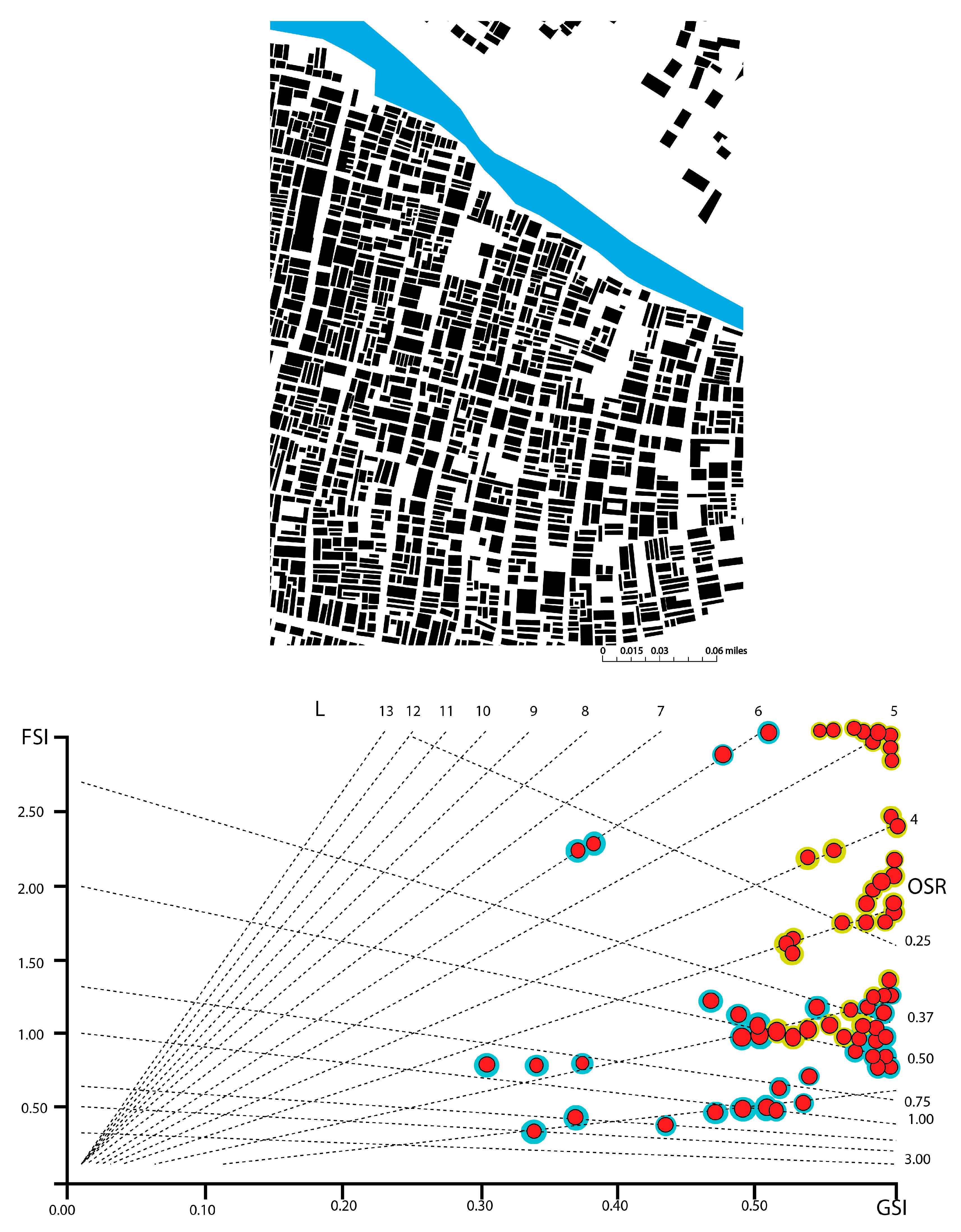
| Sample Location | GSI Values | Floors Per Building | Street Grid Integration | FSI Values | OSR Values | Comment |
|---|---|---|---|---|---|---|
| Bangshal | Moderately high 0.38–0.90 | 2–6 | Low | on both the lower and higher end 1.00–5.00 | 2.0–6.0 | Location under transition. Potential of managing storm water runoff on the ground floor. |
| Gulshan | Moderately high 0.30–0.70 | 6–15 | High | On the higher end 2.70–6.00 | 6.0–16.0 | The OSR which is also on the higher end of the graph suggests the potential of using the building volume for managing water since space is scarce on the ground level. |
| Lalmatia | Moderately high 0.35–0.80 | 2–10 | Moderate | Vary from lower to higher 0.50–6.00 | 2.0–10.0 | Location under transition. Option for micro scale water management (e.g., roof gardens or micro scale rain water harvesting systems) |
| Mirpur | Lower to moderately high 0.27–1.00 | 3–10 | High | On the higher end 1.00–5.80 | 3.0–9.0 | Potential of applying micro scale water management strategies using the transitioning building blocks (from midrise to high-rise apartments) |
| Pirerbagh | Lower to moderately high 0.40–0.70 | 1–6 | Low | Mostly low 0.25–4.20 | 1.0–6.0 | Possibility of future densification |
| Rampura | Lower to moderately high 0.40–0.80 | 2–9 | Low | Mostly low 1.00–4.60 | 2.0–8.0 | Possibility of future densification |
| Rayerbazar | Low0.30–0.79 | 3–10 | Low | Relatively higher 0.90–5.50 | 2.5–10.0 | Opportunity for managing stormwater runoff on the ground level |
| Uttara | Moderately high 0.38–0.70 | 2–9 | High | Mostly on the mid to higher end 0.70 – 5.00 | 2.0–8.0 | Possibility of future densification |
| Keraniganj | Very high 0.35–1.80 | 1–6 | Moderate | Relatively low 1.00–6.00 | 1.5–10.0 | Opportunity for future densification to meet the pressure of population increase |
© 2019 by the authors. Licensee MDPI, Basel, Switzerland. This article is an open access article distributed under the terms and conditions of the Creative Commons Attribution (CC BY) license (http://creativecommons.org/licenses/by/4.0/).
Share and Cite
Ahmed, S.; Meenar, M.; Alam, A. Designing a Blue-Green Infrastructure (BGI) Network: Toward Water-Sensitive Urban Growth Planning in Dhaka, Bangladesh. Land 2019, 8, 138. https://doi.org/10.3390/land8090138
Ahmed S, Meenar M, Alam A. Designing a Blue-Green Infrastructure (BGI) Network: Toward Water-Sensitive Urban Growth Planning in Dhaka, Bangladesh. Land. 2019; 8(9):138. https://doi.org/10.3390/land8090138
Chicago/Turabian StyleAhmed, Sanjana, Mahbubur Meenar, and Ashraful Alam. 2019. "Designing a Blue-Green Infrastructure (BGI) Network: Toward Water-Sensitive Urban Growth Planning in Dhaka, Bangladesh" Land 8, no. 9: 138. https://doi.org/10.3390/land8090138
APA StyleAhmed, S., Meenar, M., & Alam, A. (2019). Designing a Blue-Green Infrastructure (BGI) Network: Toward Water-Sensitive Urban Growth Planning in Dhaka, Bangladesh. Land, 8(9), 138. https://doi.org/10.3390/land8090138