Flooding and Land Use Change in Southeast Sulawesi, Indonesia


Abstract
1. Introduction
2. Materials and Methods
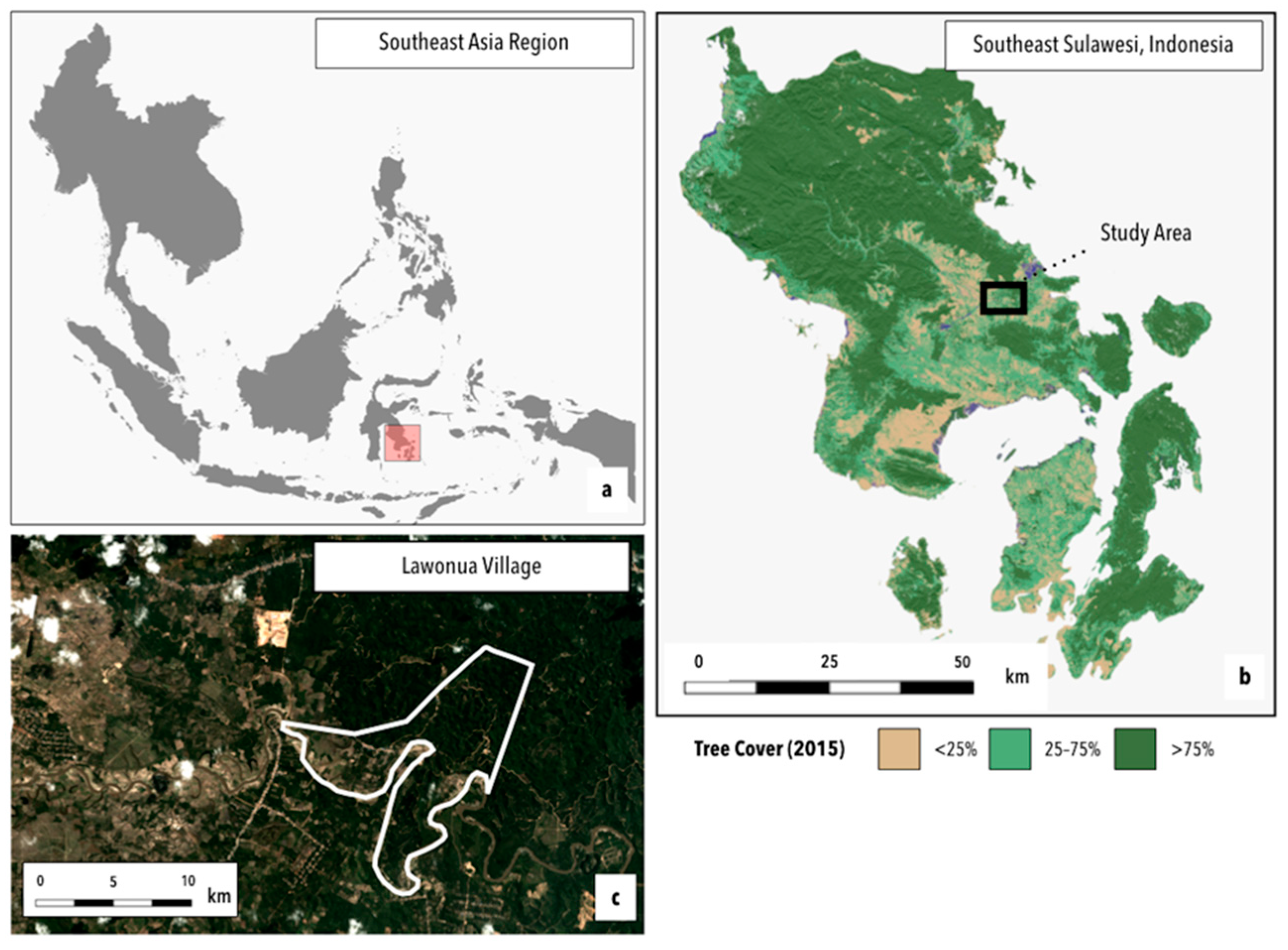
2.1. Study Area: Context and Background
2.2. Research Approach and Techniques
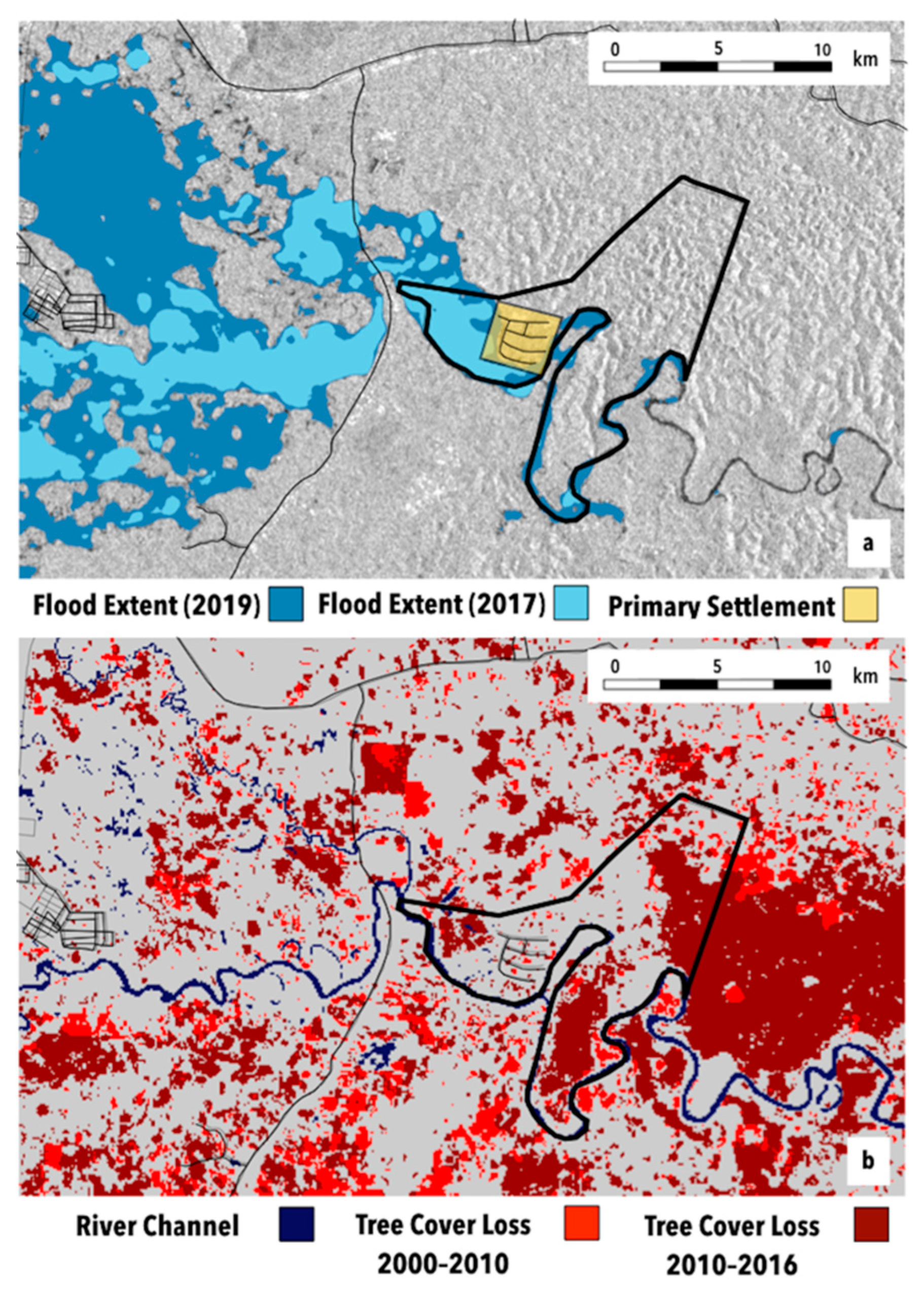
2.2.1. Reconstructing Flood Histories and Associated Landscape Context and Changes
2.2.2. Understanding Smallholder Experiences and Responses to Extreme Flood Events
3. Results
3.1. Reconstructing Flood Histories
3.2. Differentiated Smallholder Experiences of Extreme Flood Events
The drivers aren’t brave, the road as slippery as it is now. The risk is high, and there’s no guarantee [compensation for losses] from the company if there’s a work accident. There is only tolerance [for missed work], but even that is not guaranteed to everyone.
I tried to buy sago flour. Even though we Bugis people don’t usually eat sago flour, and don’t feel full when we do. But what’s to be done? There’s only that to eat at the time of the floods so that’s what I gave to my children to eat.
3.3. Responses and Alterations in Land Use Practices
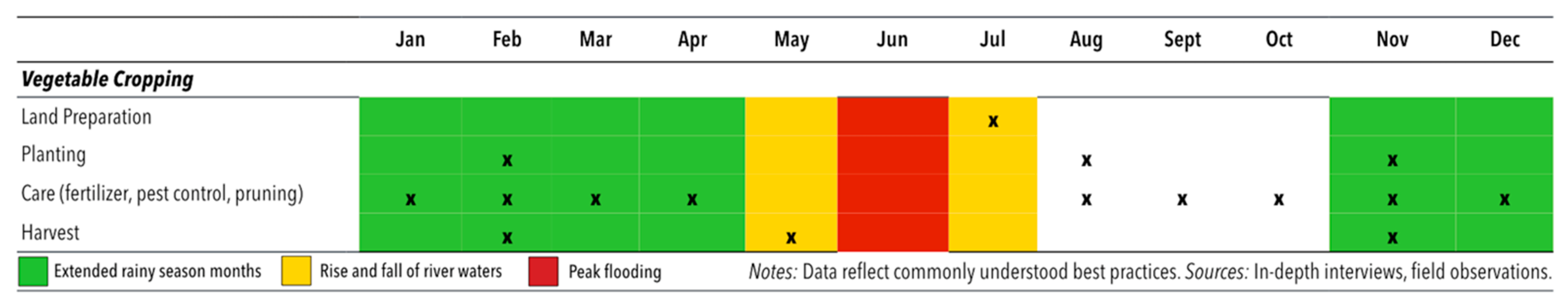
3.3.1. Relocating Vegetable Production from Riverbank to Hillside Lands
3.3.2. Transferring Lands within the Floodplains to Other Claimants/Operators
3.3.3. Adapting Land Management and Resource Use Practices
If you are forced to plant three times in a year [by need], and you happen to be late in first planting, just wait. If you’re lucky you’ll be safe, but if the third crop doesn’t finish in time, the crop is flooded.
4. Discussion and Conclusions
Author Contributions
Funding
Acknowledgments
Conflicts of Interest
References
- Leichenko, R.; O’Brien, K. Environmental Change and Globalization: Double Exposures; Oxford University Press: New York, NY, USA, 2008. [Google Scholar]
- Borras, S.M.; Franco, J.F. Political Dynamics of Land Grabbing in Southeast Asia; Transnational Institute: Amsterdam, The Netherlands, 2011. [Google Scholar]
- Radel, C.; Schmook, B.; Carte, L.; Mardero, S. Toward a Political Ecology of Migration: Land, Labor Migration, and Climate Change in Northwestern Nicaragua. World Dev. 2018, 108, 263–273. [Google Scholar] [CrossRef]
- Hirabayashi, Y.; Mahendran, R.; Koirala, S.; Konoshima, L.; Yamazaki, D.; Watanabe, S.; Kim, H.; Kanae, S. Global flood risk under climate change. Nat. Clim. Chang. 2013, 3, 816. [Google Scholar] [CrossRef]
- Seneviratne, S.I.; Nicholls, N.; Easterling, D.; Goodess, C.M.; Kanae, S.; Kossin, J.; Luo, Y.; Marengo, J.; Mc Innes, K.; Rahimi, M.; et al. Changes in climate extremes and their impacts on the natural physical environment: An overview of the IPCC SREX report. In Managing the Risks of Extreme Events and Disasters to Advance Climate Change Adaptation; Cambridge University Press: Cambridge, UK, 2012; Volume 14, p. 12566. [Google Scholar]
- Middleton, C.; Elmhirst, R.; Chantavanich, S. Living with Floods in a Mobile Southeast Asia: A Political Ecology of Vulnerability, Migration and Environmental Change; Routledge: Abingdon, UK, 2017. [Google Scholar]
- Salamanca, A.; Soukkhy, O.; Rigg, J.; Ernerot, J. Risky spaces, vulnerable households, and mobile lives in Laos: Quo vadis flooding and migration? In Living with Floods in a Mobile Southeast Asia; Routledge: Abingdon, UK, 2017; Available online: https://www.taylorfrancis.com/ (accessed on 10 March 2019).
- Thabchumpon, N.; Arunotai, N.; Arunotai, N. Living with and against floods in Bangkok and Thailand’s central plain. In Living with Floods in a Mobile Southeast Asia; Routledge: Abingdon, UK, 2017; Available online: https://www.taylorfrancis.com/ (accessed on 10 March 2019).
- Ward, P.J.; Jongman, B.; Salamon, P.; Simpson, A.; Bates, P.; De Groeve, T.; Muis, S.; De Perez, E.C.; Rudari, R.; Trigg, M.A.; et al. Usefulness and limitations of global flood risk models. Nat. Clim. Chang. 2015, 5, 712–715. [Google Scholar] [CrossRef]
- Brémond, P.; Grelot, F.; Agenais, A.-L. Review Article: Economic evaluation of flood damage to agriculture—Review and analysis of existing methods. Nat. Hazards Earth Syst. Sci. 2013, 13, 2493–2512. [Google Scholar] [CrossRef]
- Molinari, D.; Scorzini, A.R.; Gallazzi, A.; Ballio, F. AGRIDE-c, a conceptual model for the estimation of flood damage to crops: Development and implementation. Nat. Hazards Earth Syst. Sci. Discuss. 2019, 1–24. [Google Scholar] [CrossRef]
- Lyle, G. Understanding the nested, multi-scale, spatial and hierarchical nature of future climate change adaptation decision making in agricultural regions: A narrative literature review. J. Rural Stud. 2015, 37, 38–49. [Google Scholar] [CrossRef]
- Morton, J.F. The impact of climate change on smallholder and subsistence agriculture. Proc. Natl. Acad. Sci. USA 2007, 104, 19680–19685. [Google Scholar] [CrossRef]
- Wise, R.M.; Fazey, I.; Smith, M.S.; Park, S.E.; Eakin, H.C.; Van Garderen, E.A.; Campbell, B. Reconceptualising adaptation to climate change as part of pathways of change and response. Glob. Environ. Chang. 2014, 28, 325–336. [Google Scholar] [CrossRef]
- Mortreux, C.; Barnett, J. Adaptive capacity: Exploring the research frontier. Wiley Interdiscip. Rev. Clim. Chang. 2017, 8, e467. [Google Scholar] [CrossRef]
- Wood, S.A.; Jina, A.S.; Jain, M.; Kristjanson, P.; DeFries, R.S. Smallholder farmer cropping decisions related to climate variability across multiple regions. Glob. Environ. Chang. 2014, 25, 163–172. [Google Scholar] [CrossRef]
- McDowell, J.Z.; Hess, J.J. Accessing adaptation: Multiple stressors on livelihoods in the Bolivian highlands under a changing climate. Glob. Environ. Chang. 2012, 22, 342–352. [Google Scholar] [CrossRef]
- Adger, W.N.; Vincent, K. Uncertainty in adaptive capacity. Comptes Rendus Geosci. 2005, 337, 399–410. [Google Scholar] [CrossRef]
- Bassett, T.J.; Fogelman, C. Déjà vu or something new? The adaptation concept in the climate change literature. Geoforum 2013, 48, 42–53. [Google Scholar] [CrossRef]
- Bacon, C.M.; Sundstrom, W.A.; Stewart, I.T.; Beezer, D. Vulnerability to Cumulative Hazards: Coping with the Coffee Leaf Rust Outbreak, Drought, and Food Insecurity in Nicaragua. World Dev. 2017, 93, 136–152. [Google Scholar] [CrossRef]
- Belliveau, S.; Smit, B.; Bradshaw, B. Multiple exposures and dynamic vulnerability: Evidence from the grape industry in the Okanagan Valley, Canada. Glob. Environ. Chang. 2006, 16, 364–378. [Google Scholar] [CrossRef]
- Wells, J.A.; Wilson, K.A.; Abram, N.K.; Nunn, M.; Gaveau, D.L.; Runting, R.K.; Tarniati, N.; Mengersen, K.L.; Meijaard, E. Rising floodwaters: Mapping impacts and perceptions of flooding in Indonesian Borneo. Environ. Res. Lett. 2016, 11, 064016. [Google Scholar] [CrossRef]
- UNISDR. Global Assessment Report on Disaster Risk Reduction; United Nations International Strategy for Disaster Reduction: Geneva, Switzerland, 2011. [Google Scholar]
- Blaikie, P.; Cannon, T.; Davis, I.; Wisner, B. At Risk: Natural Hazards, People’s Vulnerability, and Disasters; Routledge: Abingdon, UK, 1994. [Google Scholar]
- Middleton, C.; Un, B. Living with the flood: A political ecology of fishing, farming, and migration around Tonle Sap Lake, Cambodia. In Living with Floods in a Mobile Southeast Asia; Routledge: Abingdon, UK, 2017; Available online: https://www.taylorfrancis.com/ (accessed on 10 March 2019).
- Ziegler, A.D.; Bruun, T.D.; Guardiola-Claramonte, M.; Giambelluca, T.W.; Lawrence, D.; Lam, N.T. Environmental Consequences of the Demise in Swidden Cultivation in Montane Mainland Southeast Asia: Hydrology and Geomorphology. 2009. Available online: https://link-springer-com.eres.library.manoa.hawaii.edu/article/10.1007/s10745-009-9258-x (accessed on 20 August 2019).
- Betteridge, B.; Webber, S. Everyday resilience, reworking, and resistance in North Jakarta’s kampungs. Environ. Plan. E Nat. Space 2019. [Google Scholar] [CrossRef]
- Jain, M.; Naeem, S.; Orlove, B.; Modi, V.; DeFries, R.S. Understanding the causes and consequences of differential decision-making in adaptation research: Adapting to a delayed monsoon onset in Gujarat, India. Glob. Environ. Chang. 2015, 31, 98–109. [Google Scholar] [CrossRef]
- Forsyth, T.; Evans, N. What is Autonomous Adaption? Resource Scarcity and Smallholder Agency in Thailand. World Dev. 2013, 43, 56–66. [Google Scholar] [CrossRef]
- Bryant, R.L.; Bailey, S. Third World Political Ecology; Psychology Press: Hove, UK, 1997. [Google Scholar]
- Whitten, T.; Henderson, G.S. Ecology of Sulawesi; Tuttle Publishing: Clarendon, VT, USA, 2012. [Google Scholar]
- Kelley, L.C.; Evans, S.G.; Potts, M.D. Richer histories for more relevant policies: 42 years of tree cover loss and gain in Southeast Sulawesi, Indonesia. Glob. Chang. Biol. 2017, 23, 830–839. [Google Scholar] [CrossRef]
- Kelley, L.C. The politics of uneven smallholder cacao expansion: A critical physical geography of agricultural transformation in Southeast Sulawesi, Indonesia. Geoforum 2018, 97, 22–34. [Google Scholar] [CrossRef]
- Allen, G.H.; Pavelsky, T.M. Global extent of rivers and streams. Science 2018, 361, 585–588. [Google Scholar] [CrossRef] [PubMed]
- Huang, C.; Chen, Y.; Wu, J. Mapping spatio-temporal flood inundation dynamics at large river basin scale using time-series flow data and MODIS imagery. Int. J. Appl. Earth Obs. Geoinformation 2014, 26, 350–362. [Google Scholar] [CrossRef]
- Pekel, J.-F.; Cottam, A.; Gorelick, N.; Belward, A.S. High-resolution mapping of global surface water and its long-term changes. Nature 2016, 540, 418. [Google Scholar] [CrossRef] [PubMed]
- Martinis, S.; Kuenzer, C.; Wendleder, A.; Huth, J.; Twele, A.; Roth, A.; Dech, S. Comparing four operational SAR-based water and flood detection approaches. Int. J. Remote Sens. 2015, 36, 3519–3543. [Google Scholar] [CrossRef]
- Twele, A.; Cao, W.; Plank, S.; Martinis, S. Sentinel-1-based flood mapping: A fully automated processing chain. Int. J. Remote Sens. 2016, 37, 2990–3004. [Google Scholar] [CrossRef]
- Google Earth Engine. Sentinel-1 Algorithms. 2019. Available online: https://developers.google.com/earth-engine/sentinel1#metadata-and-filtering (accessed on 19 August 2019).
- Belgiu, M.; Drăguţ, L. Random forest in remote sensing: A review of applications and future directions. ISPRS J. Photogramm. Remote Sens. 2016, 114, 24–31. [Google Scholar] [CrossRef]
- Hansen, M.C.; Potapov, P.V.; Moore, R.; Hancher, M.; Turubanova, S.A.; Tyukavina, A.; Thau, D.; Stehman, S.V.; Goetz, S.J.; Loveland, T.R.; et al. High-resolution global maps of 21st-century forest cover change. Science 2013, 342, 850–853. [Google Scholar] [CrossRef]
- Kumparan. Lagi, Dua Pengungsi Banjir di Kabupaten Konawe Meninggal Dunia. 2019. Available online: https://kumparan.com/kendarinesia/lagi-dua-pengungsi-banjir-di-kabupaten-konawe-meninggal-dunia-1rHpLWrAmfX (accessed on 15 June 2019).
- Kamarudin. Lingkungan Rusak Picu Bencana di Sulawesi Tenggara. Mongabay Environmental News. 2019. Available online: https://www.mongabay.co.id/2019/06/24/lingkungan-rusak-picu-bencana-di-sulawesi-tenggara/ (accessed on 5 September 2019).
- Direktorat Jenderal Perkebunan. Luas Areal dan Produksi Perkebunan Rakyat Tanaman Tahunan Provinsi Sulawesi Tenggara Tahun 2013; Direktorat Jenderal Perkebunan: Jawa Barat, Indonesia, 2013. [Google Scholar]
- World Resources Institute. Global Forest Watch. Land Use, Counry-Specific Data, Commodities. 2019. Available online: https://www.globalforestwatch.org (accessed on 25 September 2018).
- Nyantakyi-Frimpong, H.; Bezner-Kerr, R. The relative importance of climate change in the context of multiple stressors in semi-arid Ghana. Glob. Environ. Chang. 2015, 32, 40–56. [Google Scholar] [CrossRef]
- Burnham, M.; Ma, Z. Multi-Scalar Pathways to Smallholder Adaptation. World Dev. 2018, 108, 249–262. [Google Scholar] [CrossRef]
- Eakin, H.; Winkels, A.; Sendzimir, J. Nested vulnerability: Exploring cross-scale linkages and vulnerability teleconnections in Mexican and Vietnamese coffee systems. Environ. Sci. Policy 2009, 12, 398–412. [Google Scholar] [CrossRef]


| Year | Description |
|---|---|
| 1959 | This flood, considered by respondents to be one of the most severe in living memory, caused the collapse of a major iron and wooden bridge built during Japanese occupation (1942–1945), connecting inland regions to the capital city of Kendari. People managing lands in and around Lawonua during this time recounted water covering many agricultural fields and much of the land that subsequently became the site of a resettlement scheme in 1979. |
| 1978 | Flood waters this year extended well beyond the agricultural lands surrounding the river and inundated significant portions of the main road connecting inland regions to Kendari. The impacts of this flood in more established settlements also motivated the resettlement scheme in Lawonua in 1979 that provided 100 families with access to land and housing in Lawonua, ostensibly in areas outside the reach of flood waters. |
| 2000 | Flooding in 2000 lasted roughly a month, completely closing all but one access path in and out of the village to the main road to Kendari. The impacts of this flood were particularly felt by recent in-migrants into the area, who struggled to access sufficient food, including rice, and who had recently planted perennial crops in riverbank lands. |
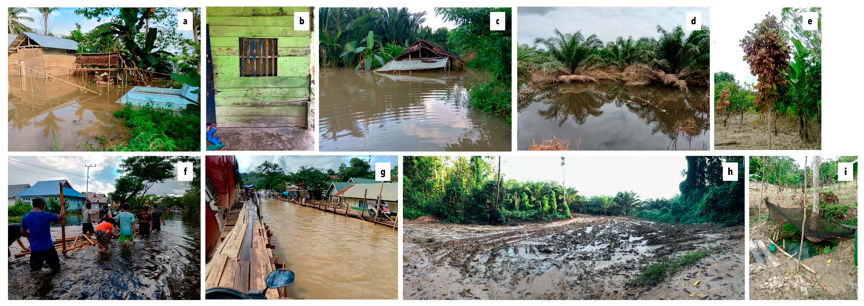
| 2013 | Flooding in 2013 lasted nearly three months (June–September), with peak flooding persisting for roughly a month and inundating portions of the road to Kendari. Roughly 15 houses in Lawonua were inundated to chest height, and landslides triggered by heavy rainfall blocked access along one of roads out of the village and affected several household hillside fields. Two deaths from the flood were recorded in the province. |
| 2019 | The inundation of agricultural lands and settlements was of much shorter duration in 2019 than had been the case in 2000 or 2013, but most respondents noted that the waters rose much more quickly than was the case in either of these prior flood events. Flood waters began to rise on June 9, before peaking on June 11 and beginning to recede around June 25. Overall, 33 houses were inundated to some degree in Lawonua during this flood. As with other major floods, mobility was disrupted on both local roads and provincial road networks. Several deaths were recorded from this flood [42]. |
| Impact | Summary |
|---|---|
| Damage to house or household property | Permanent damage to homes and household items (e.g., cabinets, televisions, mattresses, firewood) |
| Damage to infrastructure | Permanent damage to bridges, dykes, roads, health facilities |
| Damage to crops | Rotting due to water damage, change in pest/pathogen regime, full loss of crop |
| Challenges accessing clean water | Infiltration of muddy or polluted flood waters into dug wells |
| Challenges accessing sufficient or sufficiently high-quality food | High prices for dry food items and vegetables and limited access to traded food products |
| Loss of mobility | Portions of road networks unpassable given mud/heavy rain/full inundation |
| Loss of work | Land submergence and loss of access to work requiring mobility |
| Premature harvest | Crop harvested before ripe to capture some yield before flood damage |
| Market opportunity | Experienced from opportunities created by flood conditions, e.g., for vegetable producers on lands safe from flood impacts |
© 2019 by the authors. Licensee MDPI, Basel, Switzerland. This article is an open access article distributed under the terms and conditions of the Creative Commons Attribution (CC BY) license (http://creativecommons.org/licenses/by/4.0/).
Share and Cite
Kelley, L.C.; Prabowo, A. Flooding and Land Use Change in Southeast Sulawesi, Indonesia. Land 2019, 8, 139. https://doi.org/10.3390/land8090139
Kelley LC, Prabowo A. Flooding and Land Use Change in Southeast Sulawesi, Indonesia. Land. 2019; 8(9):139. https://doi.org/10.3390/land8090139
Chicago/Turabian StyleKelley, Lisa C., and Agung Prabowo. 2019. "Flooding and Land Use Change in Southeast Sulawesi, Indonesia" Land 8, no. 9: 139. https://doi.org/10.3390/land8090139
APA StyleKelley, L. C., & Prabowo, A. (2019). Flooding and Land Use Change in Southeast Sulawesi, Indonesia. Land, 8(9), 139. https://doi.org/10.3390/land8090139