Abstract
In a warming world, urban environmental stresses are exacerbated by population-increase-induced development of grey infrastructure that usually leaves minimal scope for blue (and green) elements and processes, potentially resulting in mismanagement of stormwater and flooding issues. This paper explores how urban growth planning in the megacity of Dhaka, Bangladesh can be guided by a blue-green infrastructure (BGI) network that combines blue, green, and grey elements together to provide a multifunctional urban form. We take a three-step approach: First, we analyze the existing spatial morphology to understand potential locations of development and challenges, as well as the types of solutions necessary for water management in different typologies of urban densities. Next, we analyze existing and potential blue and green network locations. Finally, we propose the structural framework for a BGI network at both macro and micro scales. The proposed network takes different forms at different scales and locations and offers different types of flood control and stormwater management options. These can provide directions on Dhaka’s future urban consolidation and expansion with a balance of man-made and natural elements and enable environmental, social, spatial, financial, and governance benefits. The paper concludes with some practical implications and challenges for implementing BGI in Dhaka.
1. Introduction
The city is a dynamic landscape characterized by natural (blue and green) and man-made (grey) elements. These elements, accumulated over time, shape the urban form and influence the behavior of residents. Over densification and unplanned urbanization leave little room for interaction among blue, green, and grey elements, and as a result, the natural elements (e.g., water, green space) and natural characteristics (e.g., topography) are deprioritized in many cities. One manifestation of this is that water—a vital structuring element—can become a challenge for the urban environment during extreme weather events such as heavy rainfall. The compact urban fabric often does not possess porous surfaces for water permeability, causing historically unprecedented flooding events.
Despite guaranteeing the protection of water bodies and actively managing water resources, many cities across the world are encountering complicated issues related to population growth, water shortage, and climate change [1]. This is more common in megacities that often confront water-related challenges [2,3]. Megacities are frequently considered as enlarged forms of cities, but in reality, the city-scale imposes immense pressure on ecology and infrastructure with added complications such as fragmented societies, higher inequality, and rising informality [4,5]. Megacities, characterized by numerous decision-making authorities, often struggle to achieve collaboration in solving urban sprawl, land use conversion, and water management problems [6].
The rapid process of urbanization in megacities is causing environmental, economic, and social problems. Development has been accompanied by negative consequences for many river systems, including changes in their hydrology and ecology. In recent decades, the increasing frequency of disaster events—including hydro-meteorological disasters—has threatened human lives and infrastructure. One of the most common water-related disasters frequently affecting urban social life, particularly in Asian regions, is flooding [7,8]. Specifically, cities are experiencing pluvial flooding due to increased urbanization and climate change [9,10,11]. Sources of water bodies capable of capturing a significant volume of floodwater are slowly disappearing as the volume of impervious surfaces rapidly escalates. As a result, urban areas are experiencing increasing high pick flow and stormwater runoff incidents that have noticeable adverse effects on social and economic lives [10,12]. Simultaneously, the remaining receiving water bodies have been polluted by mixed stormwater and wastewater, degrading their water quality.
In order to address escalating events of environmental dilapidation, resource susceptibilities, booming urban population, and other uncertain impacts from climate change, cities worldwide are reconsidering conventional urban water management systems [13,14]. Researchers have suggested numerous approaches for renovating urban systems, such as integrated water resources management [15], sustainable urban water management [15,16,17], and water sensitive cities [13,18]. Several concepts and technologies have emerged in recent years to manage urban stormwater with alternative solutions, including low impact development and green stormwater infrastructure in the USA [19,20,21,22,23], sustainable urban drainage systems in the UK [24,25], water sensitive urban design in Australia [26,27], and the ‘sponge city’ in China [28,29,30].
Within this context, the purpose of this paper is to explore if and how an urban blue-green infrastructure (BGI) network can be proposed—both at macro and micro scales—as part of a future urban development strategy for the megacity of Dhaka, the capital of Bangladesh. We attempt to answer the following research question: How can the urban structure be adapted to mediate between the need to accommodate population growth and at the same time give room for water and green spaces? We start with a literature review on BGI and discuss the current context of Dhaka. Next, we describe the three-step methodology applied in our research and accompanying results. Finally, we discuss how a BGI network can be implemented in Dhaka and offer concluding remarks.
2. Literature Review
2.1. Understanding Blue-Green Infrastructure (BGI) and Current Trends
BGI, albeit used less frequently, is an umbrella term used in planning (often in landscape planning) and is closely related to the concept of “green infrastructure” (GI) [31]. It combines the concept of green (including blue) networks [32] and ecological networks [33]. Scholars mostly draw on a standard definition given by the European Commission –
“a strategically planned network of natural and semi-natural areas with other environmental features designed and managed to deliver a wide range of ecosystem services. It incorporates green spaces (or blue if aquatic ecosystems are concerned) and other physical features in terrestrial (including coastal) and marine areas. On land, green infrastructure is present in rural and urban settings.”[34]
Compared to its earlier predecessors, more notably GI, BGI is relatively a new term which was first used for describing the planning efforts in Sao Paolo, Brazil to create a network of “green and blue” infrastructures in response to flood risks [35]. A systematic review of literature on blue, natural, ecological, and green infrastructure from 1989 to 2015 [36] suggests that there is a shift of focus observed in the transitioning from green, or natural, infrastructure to BGI. The later seeks an integrated approach, utilizing different types of eco-systems and associated eco-system services. It is a shift away from a comparatively simple “land use view” [37], towards recognizing more flexible eco-system service-based solutions [38,39] that do not only include green and blue elements and processes but also take into account man-made interventions, such as permeable pavements, bioswales, retention basins, and constructed wetlands as an integrated whole. The present paper aligns with the later body of works and the definition provided by Ghofrani that BGI is
“an interconnected network of natural and designed landscape components, including water bodies and green and open spaces, which provide multiple functions such as: (i) flood control, (ii) water storage for irrigation and industry use, (iii) wetland areas for wildlife habitat or water purification, among many others.”[40] (p. 499)
This later approach to BGI moves away from earlier engineering discourses that proliferated through the conceptualization of green infrastructure mostly for the management of water in urban areas. A range of nomenclature and acronyms were used to define different, or sometimes very much the same, elements, designs, and purposes [41]. Studies have used different nomenclature and acronyms for water management in literature since 1980s [14]. The approach to BGI in the later period, more closely evolves from the concept of water sensitive urban design (WSUD) [13] which shows a clear emphasis on the ‘blue’ elements (e.g., rainfall and flood) to describe the infrastructure [41]. Liao et al. [42] further clarifies that BGI is a particular type of green infrastructure involving a network of landscape systems, which often combine both natural and artificial materials, and is purposefully designed and managed to provide (storm) water-related ecosystem services (see also Fletcher et al. [14], for a review of the concept).
By adopting the term BGI, the present paper shifts away from an earlier fragmented and to some extent elective approach to blue elements as indicated by European Commission’s definition (“or blue if aquatic ecosystems are concerned” [34]). Through the use of the term BGI, this paper attempts to recognize the active agencies of and adequate sensitivity to the water elements in planning urban infrastructure. In this regard, the paper also acknowledges the notion of “intentional landscapes” [43] (p. 133) in encapsulating BGI, not just comprising of natural landscapes but also made out of man-made elements. This approach to BGI helps a greater recognition of an array of ecosystem services (e.g., water purification, heat retention, as well as cultural and economic benefits) with a higher sensitivity towards human interventions, i.e., planned or designed urban spaces [44]. BGI, in this paper, is approached as purposeful and intentional, not just the remnant or leftover landscapes but designed and deployed primarily for social, economic, and environmental benefits [45,46], yet without compromising but sustaining natural processes [47].
Many studies have focused on BGI, but most of them seek to highlight the benefits of BGI [48]. In countries such as the Netherlands and Sweden, BGI is well accepted; however, the theoretical considerations of how the concept of BGI can inform the practice of planning remain undeveloped. BGI represents a conceptual shift from conventional approaches to water management, emphasizing the natural landscape [49] to provide “resilient and adaptive measure to deal with flooding by mimicking pre-development hydrology” [50] (for example, detention and retention techniques). This approach reduces stress on ‘grey’ infrastructure in urban areas [51]. Thus, planning for BGI is significantly different from conventional planning that historically relied too much on ‘hard’ built infrastructures, such as streets, sewage and drainage systems, and utility lines [31]. From the experiences of the Malmo City Council in Sweden [52], it is recommended that a careful balance is needed between hard and soft elements for a successful BGI through the incorporation of blue and green infrastructure among existing land uses where sealed or paved surfaces can be effectively minimized. Research also reinforces that planning for BGI should aim for a “symbiotic” relationship between the city and its region [53]; the emphasis should be on enticing more polycentric development and multiple densities across the entire region. Overall, there is a call for a more integrated mix of blue, green, and grey elements in which “the boundary between the natural and the technical networks is blurred” [53] (p. 9).
In the rest of the paper, a range of literature informs the investigation, analysis, and the overall approach of designing the BGI networks in the context of Dhaka, Bangladesh. Aligning with Ahern’s [54] recommendation, the paper adopts a ‘multi-scalar’ planning approach to implement BGI integrating both micro (i.e., land parcel and neighborhood) and macro levels (i.e., urban and peri-urban region). Scholars have suggested the ‘scale’ in terms of regional/urban and private /public component in a given urban area [55]. Some key studies [56,57] propose for three spatial relationships that need to be taken into account when implementing BGI: site-specific elements, linkages, networks and connectivity [58], and other broader (regional) scale landscape elements. This paper also follows Hansen et al. [59], who recommend promoting ‘multifunctional’ BGI for high-density urban areas. BGI is well suited for dense urban areas as it reduces the need to upgrade or expand conventional stormwater/drainage system, both spatially and financially [42]. Following Hansen et al. [59], the first step of designing a BGI network involves a systematic “spatial assessment” of the urban morphology to identify all blue and green spaces at the ‘site-level’ as well as ‘city-wide’ that could be strategically organized in the future to meet multiple functions (p. 99). The second step focuses on the ‘connectivity’ of blue and green corridors as a critical component. The third step combines the two to envisage a multi-scalar solution that incorporates Dhaka’s urban morphology and the dynamics of water.
2.2. Context: Water and Dhaka’s Urbanization
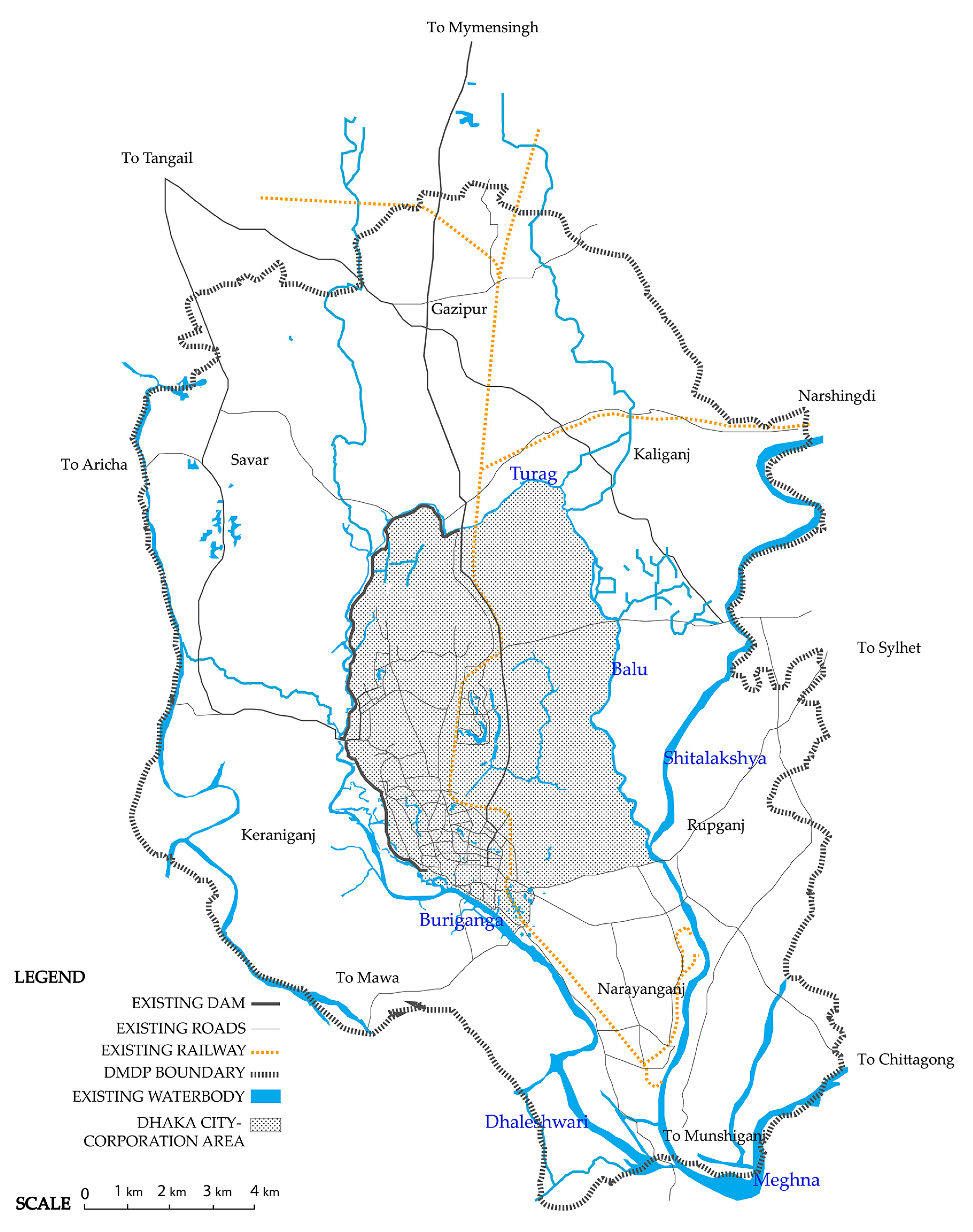
Dhaka—one of the world’s most densely populated megacities with 17 million people—is geographically situated in the deltaic plain of three major rivers: Padma, Brahmaputra, and Meghna, and surrounded by tributaries of these major rivers (see Figure 1). To describe Dhaka’s historical context, in this section, we mostly rely on Rahman’s edited collection [60] that collate facets of Dhaka’s urban social and spatial transformations. Dhaka traces back its origin in the 17th century as a trading hub of the Mughals. As water played a principal role in transportation at that time, the city was not only structured by the bodies of water that flowed through it, but also culturally constructed as ‘the river city’. At this time, the city’s boundaries were clearly defined by the tributaries: Buriganga to the south, Turag to the north and west, and Balu to the east, as well as the swampy lands all around.
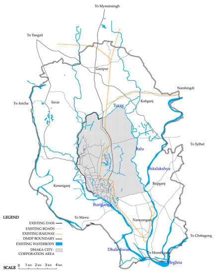
Figure 1.
Location of Dhaka at the territorial scale, at the confluence of three major rivers.
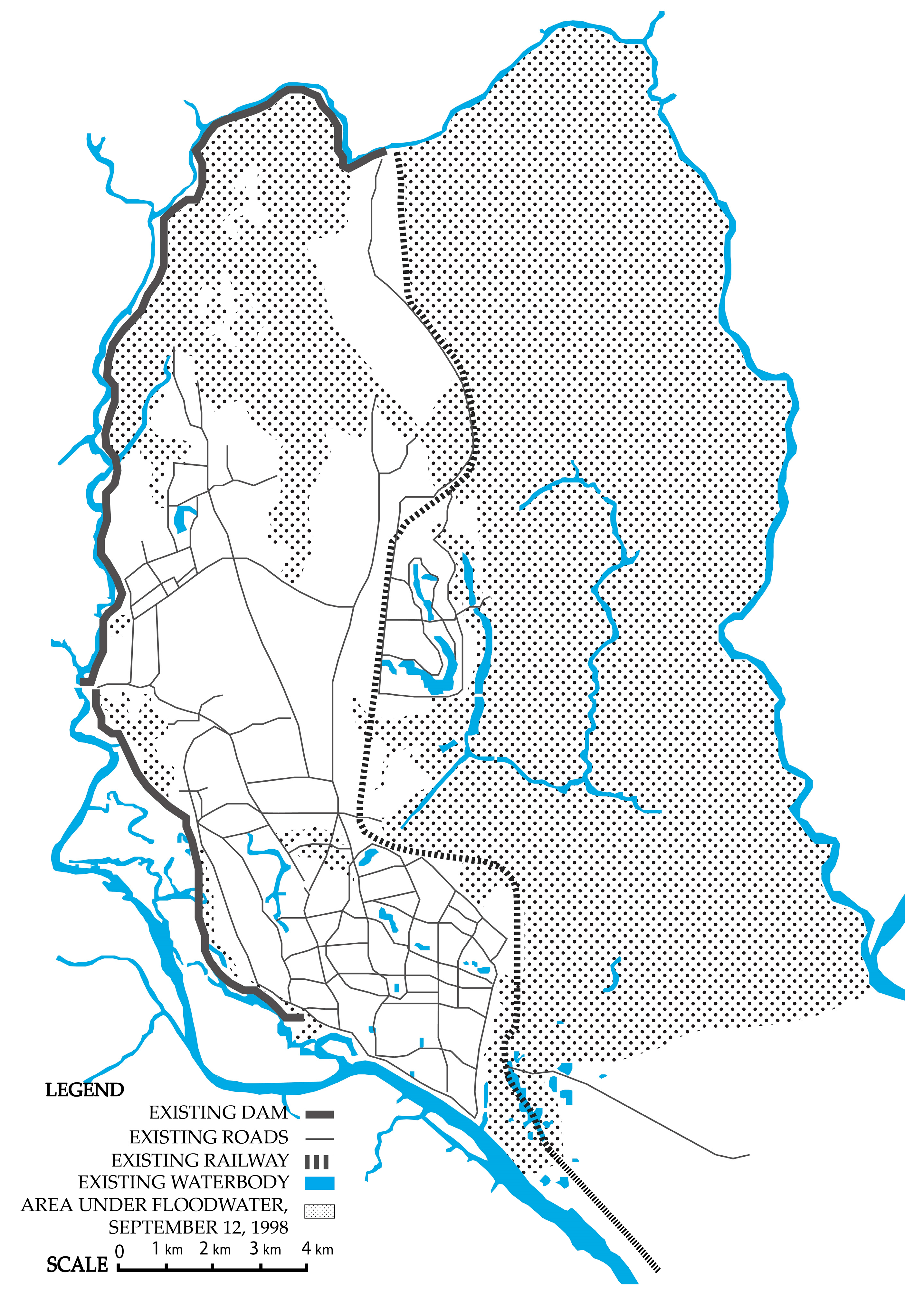
The story of Dhaka is similar to many highly urbanized cities of contemporary time such as Delhi and Shanghai that neglected their water systems to find room for growth, if seen from a morphological point of view. The city underwent different phases of development throughout history. In the 16th century Mughal rule, the development followed the river Buriganga in the east-west axis. During the British rule of the 17th century, the city started to grow toward the north because of the relocation of the industrial zones and the connection with railway lines. The 18th century was all about the coexistence of the city and the river where the city development respected the river course and used it as the network of the main transportation system. After the independence of Bangladesh in 1971, the city expanded in all directions, maintaining the tradition of a centralized capital city with a concentration of all governmental and private developments. The historical flooding event of 1988 put 75% of the city under water (see Figure 2). As a result, the western riverbank was protected by dam construction, which in the later phases caused dense urbanization process along the dam, keeping minimum room for the river. With the development of other grey infrastructures, waterways eventually became a forgotten backyard of the city.
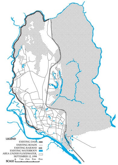
Figure 2.
Flood-affected areas during the historic 1998 flood in Dhaka.
The phenomenon of rural-urban migration has worsened the situation as the city doubled in size from 1990 to 2005 [61]. The U.N. predicts, by 2025, the population of Dhaka will cross 20 million making the city larger than Jakarta, Mexico City, or Shanghai today [62]. New residents move to Dhaka every day, seeking residence in the low-lying lands—by filling up water retention basins, river beds, or even portions of a river itself [63].
The process of neglecting water in urban planning and development brought about both physical and metaphorical consequences. People started perceiving water as an element to neglect, polluting and encroaching its banks indiscriminately without any concern of environmental impacts on the overall city landscape. The waterways that used to clearly define the limit of the urban–rural condition of the city are blurred today. The city continues growing in all directions, keeping bare minimum porosity in the urban tissue. The city’s green landscape is also a distant memory with more than 1000 ponds, canals, and parks replaced by houses, workplaces, and markets; now, only 5 percent in old parts and 12.5 percent in new parts of the city is composed of green areas [64]. The most common trend in Dhaka is to build multi-storied buildings on smaller parcels with minimal open space preserved. Private developers are filling up low-lying areas, including wetlands and marshlands, specifically on the eastern part of the city (see Figure 2). Such development patterns are resulting in severe scarcity of pervious land for rainwater to permeate and recharge the ground. Since the surface runoff cannot accumulate on the eastern lower side of the city, it causes high amounts of water clogging all around the city during major rain events. The inner part of the city that used to have water channels connecting the rivers on both sides has been occupied over time. Subsequently, there is not sufficient surface water corridors to channel the water from the inner part of the city to the downstream areas. High rainfall coinciding with a high-water level in the river quickly floods the city because stormwater cannot be naturally drained through the remaining water system that is in part due to the insufficient drainage system. As a result, frequent flooding events have increased in the last decade. The city now struggles relentlessly for the survival of its few remaining water courses and very often fails to withstand the pressure of the urbanization process that either completely ignores or mostly replaces the natural system with asphalt surfaces.
This paper addresses the opportunity to rethink how to accommodate future inhabitants of the city without necessarily compromising the blue (and green) infrastructural elements (e.g., water and green/open spaces) while possibly reviving those that have been lost. The recognition of the importance of blue and green natural elements as a structural tool is evident in the recent Draft Dhaka Structure Plan 2016–2035 [65], where significant spatial strategies have been premeditated to re-organize the future growth development pattern. The structural plan proposes to identify special zones for protecting and preserving natural areas for both flood management and recreational purposes. Notably, the plan identifies strategies for reclaiming the illegally occupied flood-flow zones in the city to be implemented in the coming years. In the context of the future urban development strategy, the following sections explore the potential of BGI networks—both at macro and micro scales.
3. Materials and Methods
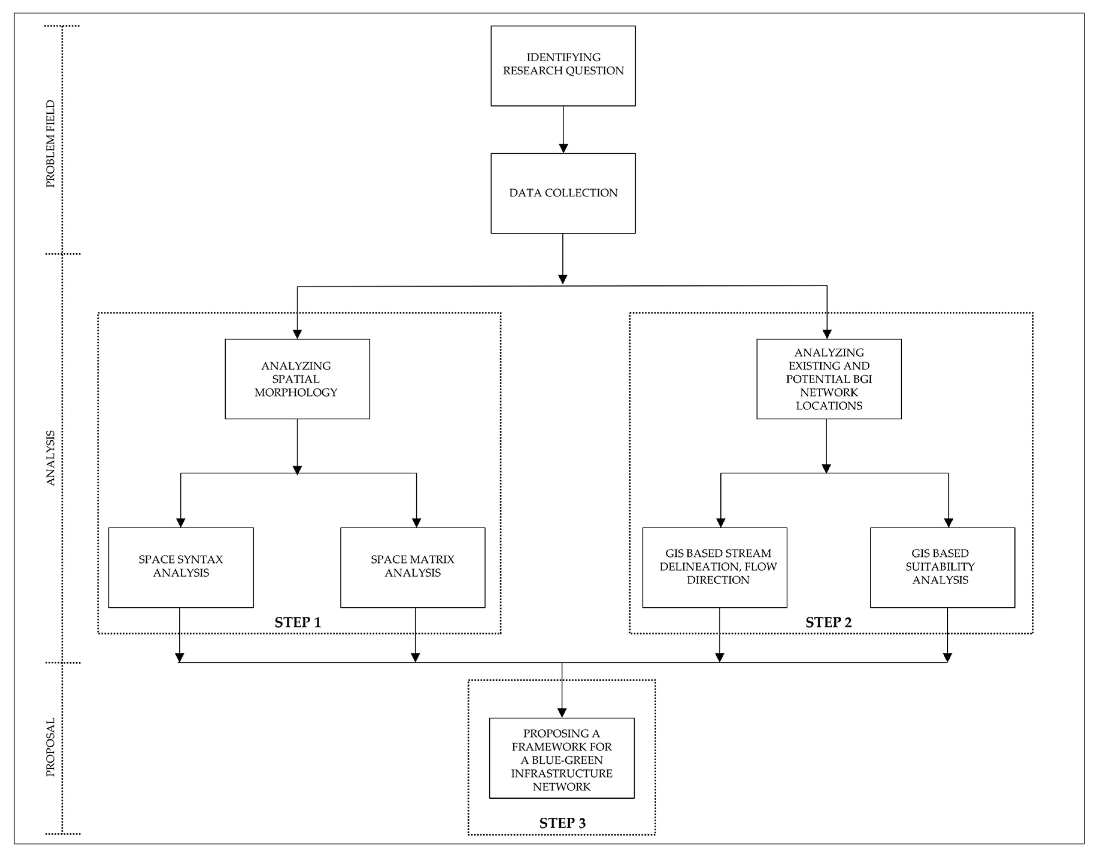
We addressed our research question—how the urban structure can be adapted to mediate between the need to accommodate population growth while preserving natural resources—by taking a three-step approach described below (see Figure 3). The process of designing a BGI network, including the methodology and results of this three-step approach, is presented in this section. We collected GIS data from Dhaka City Corporation (administrative boundaries, parcel boundaries, building footprints, building heights, number of stories per building), Dhaka Water Supply and Sewerage Authority (rivers and waterways, wetlands, topography, and flood plains), Geodash (parks and open spaces), and Bengal institute (streets and other infrastructure).
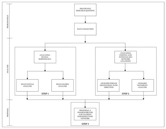
Figure 3.
A graphical framework to represent our methodological approach.
Step 1—Analyzing Spatial Morphology: The primary author conducted a city-wide spatial morphological analysis to understand potential locations of development and challenges. This included a space syntax analysis and a spacematrix analysis (described below). The analysis was done based on an understanding that Dhaka’s morphological structure differs across the city and, therefore, the same development strategy should not be applied to the whole city. The southern part of the city from the 1600s, for example, still has its narrow organic web-like street pattern with smaller parcels. The upper northern and eastern new towns, on the other hand, also have small parcel sizes but with wider streets following a grid-iron pattern. The morphological patterns of the rest of the city were either grown organically, owned by the army, or built illegally and later blended with the other parts of the city.
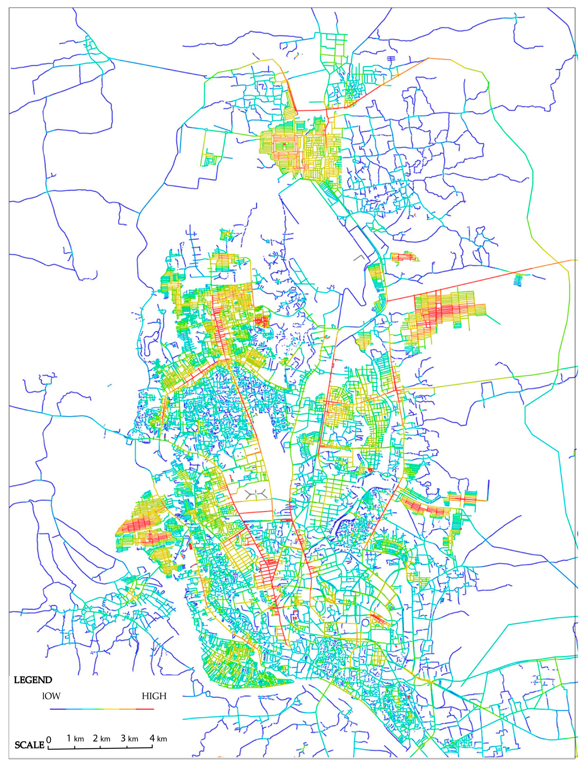
Space syntax is built on quantitative analysis and geospatial computer technology and provides a set of theories and methods for the analysis of spatial configurations of various kinds and at all scales [66]. The global axial integration analysis with a radius of “N” expresses the vehicular movement or street connectivity in the context of the whole city, whereas a radius (e.g., 2, 3, 4, 5) represents connectivity/integration at the local level. Radius 2, for example, stands for two steps away from each element, where a step stands for a change in directional turns from each element in a system. The higher the value of the radius, the closer it is to global axial analysis. In axial analysis, topological depth is the change in direction between one axial line and another that has no geometric value. Integration represents potential distance in a system and these destinations are highlighted from red to blue representing most integrated and segregated areas respectively [67].
We used the space syntax software to understand the integration of street network in Dhaka (or depth map analysis) and also to use the outputs of street integration as inputs in the Spacematrix analysis (described below) in order to understand the relationship between the levels of street integration with types of urban densities. First, a global axial analysis was conducted by editing the street network GIS shapefile collected from Dhaka City Corporation. Each vector line of the street network was edited in AutoCAD to intersect and thus prepared for a depth map analysis. After importing the converted dxf file into depth map, the map was converted to an axial map.
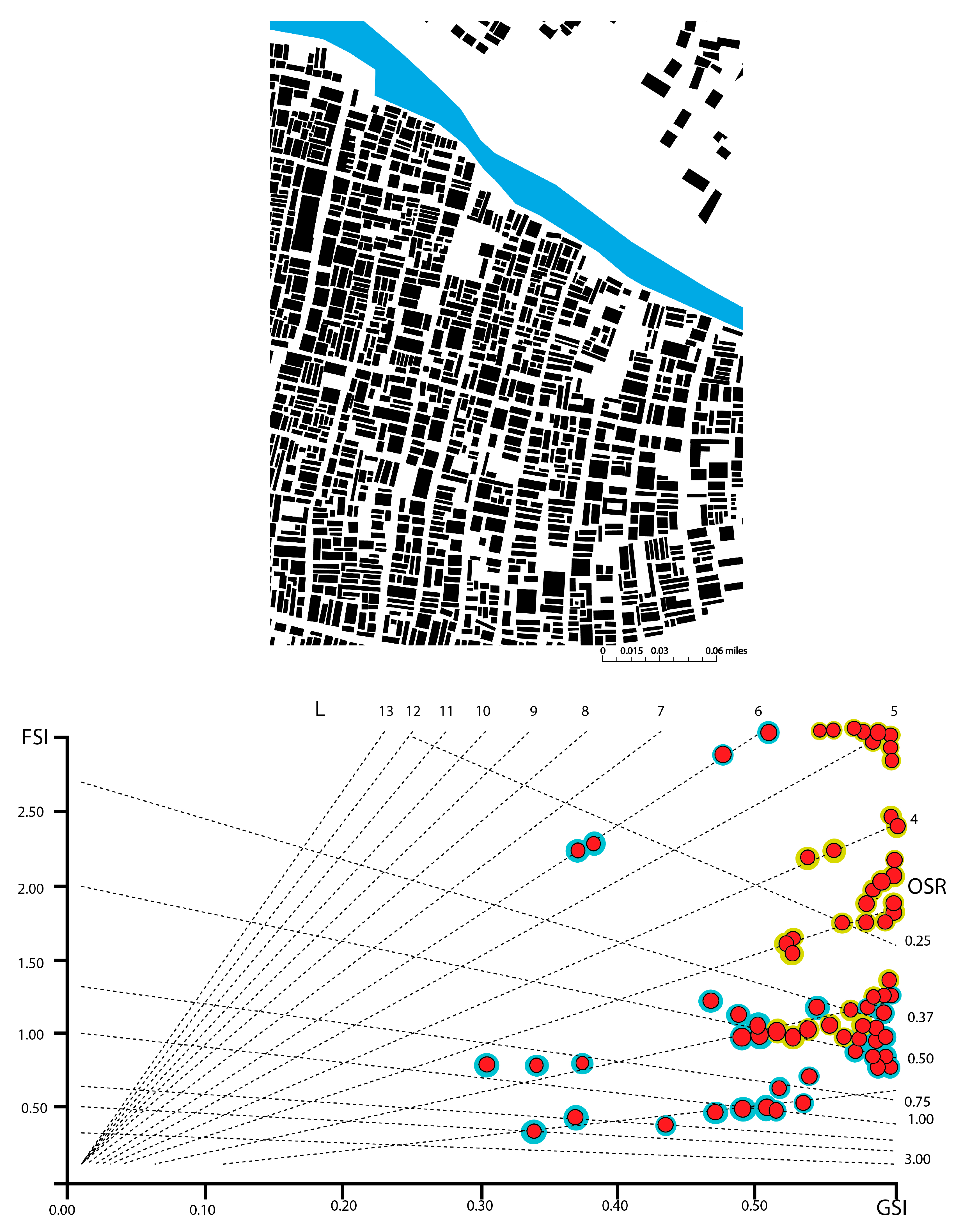
The method of Spacematrix is used to efficiently calculate urban density and understand the correlation of density and urban form—as well as the composition of built and unbuilt areas—by taking the street block as the smallest aggregation unit [68]. Spacematrix has the following parameters: floor space index or FSI (gross floor area/plan area), ground space index or GSI (built area/plan area), and network density (N), which can be calculated from a space syntax analysis (described above). These three measures are represented in a three-dimensional diagram. The open space ratio (OSR), the average numbers of floors (L), and the size of urban blocks (W) can be understood from that diagram. The readings of FSI, GSI, and OSR inform us how dense urban blocks are and what the amount of pressure is in the open space on those blocks.
We conducted this analysis using building and parcel shape files from Dhaka City Corporation. Parcel size and building footprints were calculated using a GIS. The values were used to calculate FSI, GSI, and OSR. All values were plotted on the graph using red dots. Each red dot was overlapped with blue, green, or yellow dots to represent low-, moderate-, or high-integrated streets respectively—resulting from their corresponding streets from the Space syntax/depth map analysis.
Step 2—Analyzing Existing and Potential Blue and Green Network Locations: The purpose of this step was to identify possible options for new blue-green corridors combining the existing water network, hidden streams, potential stormwater infrastructure locations, and existing green spaces—these can work together as a system and can drain stormwater runoff during heavy rainfall events. Using data on topographical configuration and existing water bodies of the city, we ran a GIS-based stream delineation model to identify the hidden streams that are buried under current development (e.g., buildings, streets, other impervious features). We also delineated the flow directions of rainwater on the ground based on their elevation level. We mapped existing green spaces (e.g., parks, open spaces) within the city and finally conducted a GIS-based suitability analysis to identify suitable locations for potential green stormwater management projects. Criteria used for the suitability modeling included elevation (areas with lower elevation are highly suitable), waterways (areas closer to waterways are highly suitable), rivers (areas closer to rivers are highly suitable), hidden streams (areas closer to hidden streams are highly suitable), and parks and open spaces (areas within parks and open spaces are highly suitable).
Step 3—Proposing a Framework for a Blue-Green Network: We overlaid all the outputs from steps 1 and 2 so that the framework for a BGI network followed a bilateral process to address two major concerns: morphological characteristics and water dynamics. These two concerns, however, needed a multi-scalar solution—territorial (macro) and local (micro). Therefore, we reviewed government proposals for the macro-level structure plan of greater Dhaka that, among other topics, focused on population growth management and flood control. As the final step, we proposed a framework of a BGI network.
4. Results and Recommendations
Step 1—Spatial Morphology:Figure 4 shows the result of space syntax analysis; the color range from blue to red indicates the level of street integration from lower to higher values. This result helped us identify streets that are not globally highly connected, and which can be converted to water carrying structures to create an integrated water system.
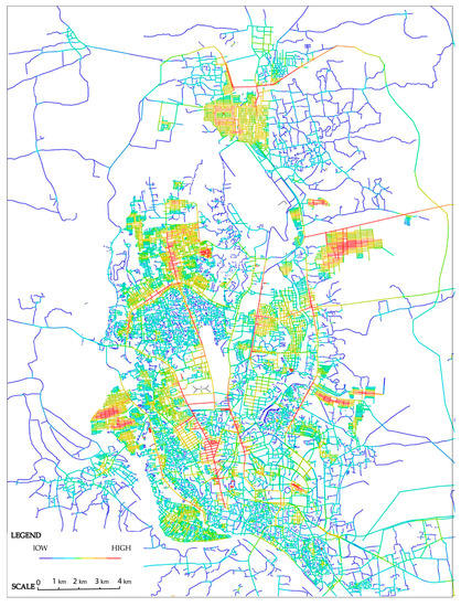
Figure 4.
Results of Space Syntax analysis. Blue to red represents lower to higher street integration.
Figure 5 shows the results of the Spacematrix analysis for an area in Keraniganj as an example. FSI on the Y axis gives an impression of the intensity of the built environment of a particular area and GSI on the X axis shows the compactness or openness of that area. OSR represents the spaciousness or the pressure on the unbuilt area, and the L represents the average number of floors. The street blocks having GSI values from 0.30 to 0.90 with FSI values from 1.00 to 6, are located in the areas where streets are comparatively less integrated. On the other hand, the street blocks having GSI values from 0.35 to 1.80 with FSI values from 2.00 to 6.00 are located in the areas where the streets are more integrated. Overall, the majority of the blocks of Keraniganj show higher ground space intensity (GSI) values which indicates the high compactness of this area. On the other hand, the majority of the street blocks showing low floor space intensity (FSI) values indicate the possibility of future densification of this area.
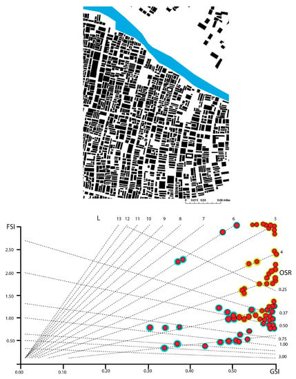
Figure 5.
Results of Spacematrix analysis for an area in Keraniganj as an example.
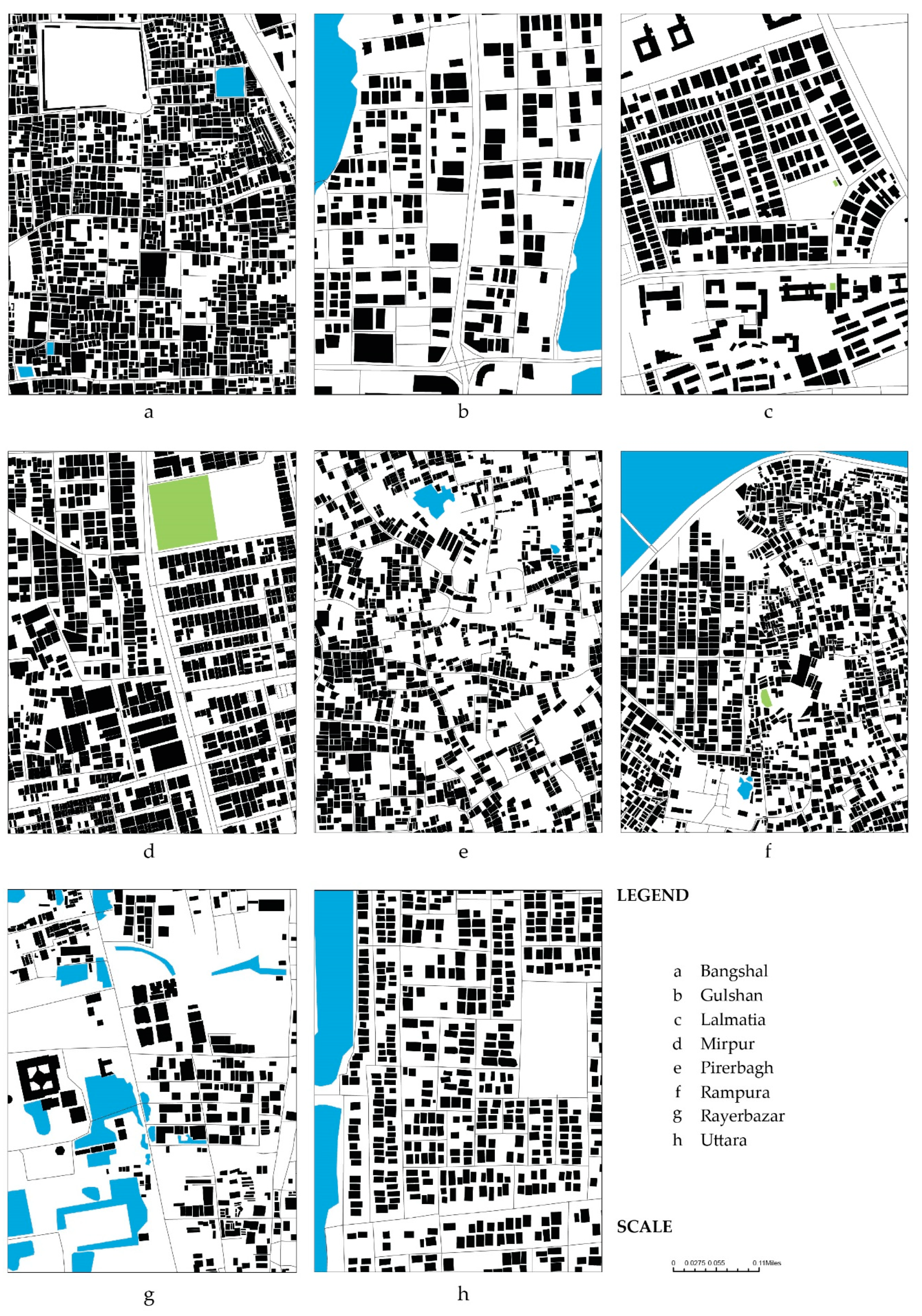
Table 1 lists the results of the morphological analysis of nine selected areas in Dhaka, representing different types of development patterns (as shown in Figure 6, see Figure 5 for Keraniganj) and different historical, political, and economic influences. The major phases of socio-economic and political change, including the Hindu period, the Mughal period, the Pre-colonial period, the Colonial period, the Pakistan period, and finally the Bangladesh period shape the growth of different morphological typologies in different parts of the city, constituting the driving force of the selection of these nine locations.

Table 1.
Morphological analysis results of nine selected areas in Dhaka.
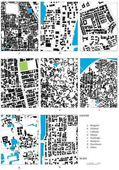
Figure 6.
Ground space intensity and spatial pattern of eight selected areas in Dhaka.
Overall, this spatial morphology analysis allowed us to categorize the blocks in Dhaka according to different qualities to be densified or restricted for development in the future. It also helped us understand what kind of solutions would be necessary for water management in different typologies of urban densities.
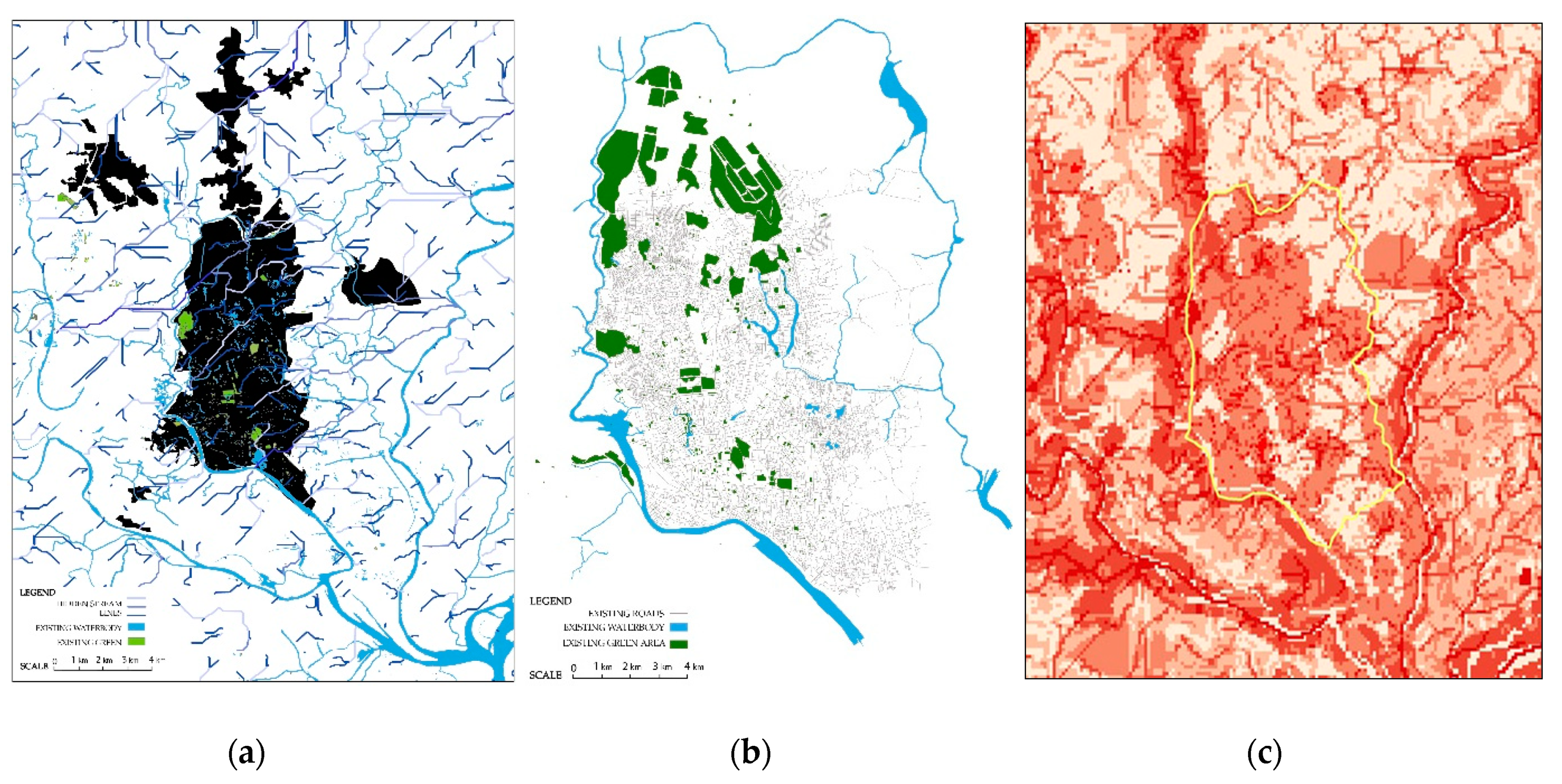
Step 2—Existing and Potential Blue and Green Network Locations:Figure 7a shows the delineated hidden streams along with existing water network, Figure 7b shows existing green areas, and Figure 7c shows the results of the suitability analysis (darker red represents highly suitable areas). Overall, this analysis assisted us in step 3 (proposal phase) to identify the areas following hidden streamlines where the peripheral water network could be connected through the existing urban fabric in order to better manage stormwater runoff. It also helped us identify the locations for stormwater infrastructure in upstream, midstream, and downstream to slow down the process of the natural drainage system.
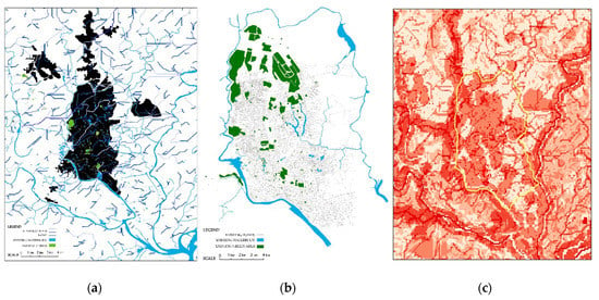
Figure 7.
(a) Hidden streams and existing water network. (b) Existing green areas. (c) Suitable locations for green stormwater infrastructure (darker red represents highly suitable areas).
Step 3—A Framework for a BGI Network: A review of Dhaka Structure Plan 2016–2035 suggested long term strategies for macro-scale decentralization in order to reduce pressure on the city core. Government proposals included strategic development zones (e.g., satellite towns) with varied density outside the core area, circular/ring roads to serve the flow of traffic outside the core area, and a park system to improve the quality of the urban environment. We conceptualized that a BGI network at the macro scale could guide the development of future satellite towns, by channeling the natural water system of the whole territory [65]. Based on our proposal, a BGI network can provide both a direction on urban expansion zones and limitation on urban control zones by focusing on nature as the main guiding and limiting factors respectively.
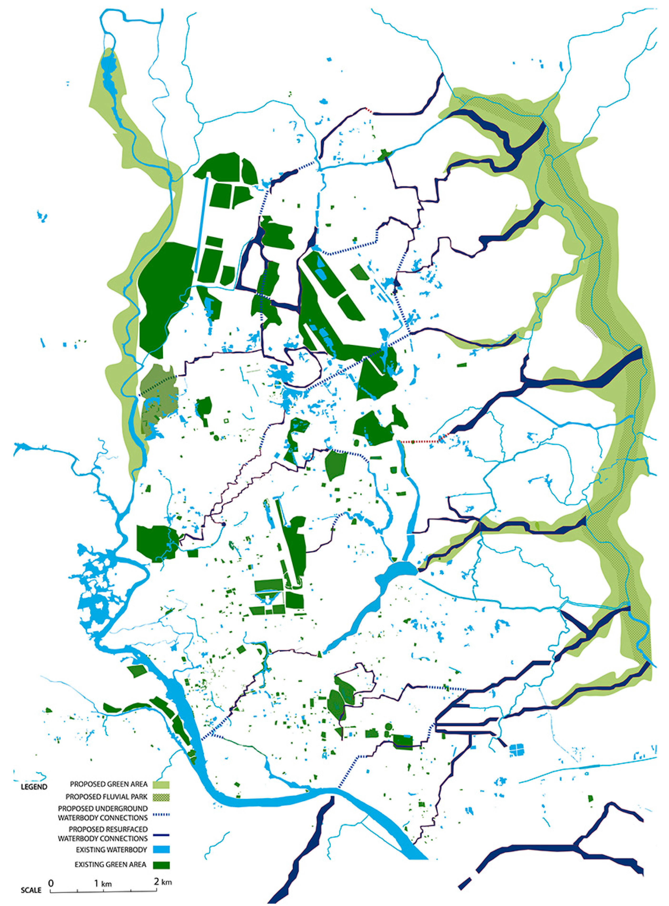
Figure 8 shows the water system as a combination of the existing ones and newly proposed corridors—based on re-surfaced/retrofitted hidden streams and existing groundwater recharge areas—for the BGI network. The new water corridors while crossing existing highly dense urban areas would follow different types of patterns—sometimes following the less integrated streets, channeling underground, or incorporating existing smaller but open water bodies to accommodate excess water in extreme cases. While crossing upstream, midstream, or downstream areas, the network would slow down stormwater runoff, store water in identified appropriate locations, work as usable water reservoirs, or drain the excess runoff to the downstream. Multi-scalar rainwater storage areas would supply water in the urban areas and reduce pressure on the groundwater resource. Detention areas in the downstream would be integrated with the highly urban tissue. Loose urban tissue in the upstream area would turn into bigger retention areas and be preserved against unplanned urbanization. In some cases, the streets with low integration values would be retrofitted as water carrying structures/blue-ways with different strategies appropriate in different locations, including both subsurface and surface flow systems. The green network following the water channels would have multi-functionality. Sometimes, in the case of stormwater overflow during heavy rainfall, it might work as a fluvial park, agriculture land, energy park, or meadow. This macro-scale blue-green parkway, while crossing urban areas, would become fragmented at different scales following existing characteristics of different urban densities. Sometimes, in areas closer to the urban core, it would serve as a series of smaller-size neighborhood parks and accommodate collective recreational activities in order to bring people closer to rapidly diminishing green spaces. The BGI network, therefore, would not only manage the water system of the city but also limit the development of environmentally sensitive areas where more productive and recreational spaces can be activated with different social or cultural programs along its trajectory.
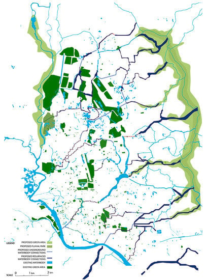
Figure 8.
The proposed blue-green infrastructure (BGI) network at macro scale.
By setting the basic parameters for future development at the macro-scale, it is possible to delve further into the local or micro-scale strategies, which vary by locations. Different morphological configurations and levels of the street integrity at local levels opened up the requirement of multi-scalar approaches for stormwater management as well as different types of densification or controlling strategies for areas with a different FSI and GSI index. The BGI network would be an appropriate solution for water management in highly dense urban areas with high FSI and low GSI index. Densification would be needed in the areas with low FSI and development control in the areas with high FSI index. The micro-scale interventions of the BGI network would include various types of green stormwater infrastructure projects at different scales—buildings, parcels, blocks, or districts—to recharge groundwater, circulate rainwater runoffs, and connect the missing links of waterways to the drainage system. The key concept would be to promote composite water management structures that encourage social lives and activities and systematically drain excess water (see examples of dual-functionality of green stormwater infrastructure projects in Meenar [22]). Examples of such interventions include green roofs at the building level, bio-swales and rain gardens at the parcel or block level, and stormwater detention sites and blue-ways at the district level.
5. Discussion
The proposed BGI network may have significant practical (and planning) implications in achieving a sustainable urban form for Dhaka. First, the BGI network addresses two major challenges of Dhaka: (i) As the center of economic, educational, productive, and administrative sectors of the whole country, Dhaka faces extreme pressure of population influx and rapid urbanization and (ii) severe flooding and stormwater management issues have created challenges for current and future urbanization. The proposed water corridors include existing water features and ground water recharge areas, as well as re-surfaced (and retrofitted) hidden streams. The corridors take different forms at different scales and locations—upstream, midstream, or downstream—and offer different types of flood control and stormwater management options. Green ‘corridors’ [58] following the water channels may ensure flexible and diverse eco-system services [38,39], such as fluvial parks, agriculture land, energy parks, meadows, and small-size neighborhood breathing spaces. These serve as ‘multifunctional’ [46,57,59] spaces providing the much-needed room for green spaces in a dense urban context and recreational opportunities for residents. At the same time, they become an integrated part of the water retention and channeling system during extreme rainfall events. Overall, the proposed BGI network provides directions on the regeneration of the existing urban fabric, future urban growth direction, and puts restrictions on development in environmentally sensitive areas.
Among the many possible ways of implementing a BGI network in an urban setting, we have shown a way of structuring BGI with specific foci on tackling the realities of high urban density; namely, the continuing negligence to blue (and green) elements of the city and future risks from climate change and overwhelming urban growth. We have provided some principles and guidelines for the megacity of Dhaka that would allow different stakeholders to follow a conceptual and structural background for its future development. The strategies at the macro-scale would help in protecting and limiting development in water-sensitive areas, whereas the strategies at the micro-scale would encourage new water-sensitive developments in the fringes of the city. Together, these can produce more compatible morphological pattern respecting the existing landscape topology while simultaneously accommodating water and people in harmony.
It is often evident in the context of Dhaka that a higher degree of pessimism surrounds the planning and implementation of large infrastructure projects because of weak governance regimes leading to a lack of citizen trust in public institutions. This is compounded by a lack of citizen participation in the conception, planning, and implementation phases; lack of political will for collaboration among stakeholders and multiple overlapping bodies (e.g., Capital Development Authority or Rajdhani Unnayan Kartripakkha, Dhaka Electric Supply Company Limited, Dhaka Water Supply and Sewerage Authority, Public Works Department, Urban Development Directorate); and the complexities surrounding ownership of land. Notably, the implementation of comprehensive citywide infrastructural solutions become difficult because of budgetary constraints. The culture of multiple organizations doing the same work “affects the development plans having the absence of role casting principle” [69] (p. 331).
Our approach to implementing a BGI network can address such difficulties in a number of ways. First, the proposal emphasizes the adoption of a multi-scalar approach that combines both micro-level (private lot) and macro-level (city-wide) interventions within an integrated system. Such a scalar approach creates opportunities for engagement by different stakeholders at different scales. For example, community engagement may be leveraged to restore blue and green spaces at the parcel or block level through green stormwater management practices such as rainwater harvesting, bio-swales, and porous ground covers; public-private partnership may be leveraged at the district level multi-functional stormwater detention sites. Second, the proposed corridors can accommodate fluvial park, community garden projects, agricultural lots, and energy parks. These spaces could enable successful public-private partnership and citizen communing projects. Previous studies [70] have already proven the value of multi-scalar BGI network that provides opportunities for developing different urban forms ranging from privatized spaces (e.g., roof garden, backyard garden) to more community-owned and cooperative spaces (e.g., power transmission corridors, easements, and alleyways).
In a warming world, urban environmental stresses (e.g., flood, heatwave, etc.) are exacerbated by population-increase-induced development of grey infrastructure. As the BGI network, in principle, strives to incorporate both natural (blue and green) and man-made (grey) elements [37], it can be a more financially and spatially efficient solution for Dhaka. As advised by Liao et al. [42], BGI, with a greater carrying capacity than conventional infrastructure, can serve a greater population size and, would reduce the need for implementing new grey infrastructure. Furthermore, increasing reliance on the natural elements as an infrastructural strategy could reduce ‘stress’ [51] on the existing and underperforming grey infrastructure of Dhaka which are evidently failing due to unprecedented environmental forces caused by climate change impacts.
BGI holds the promise of achieving more sustainable urban form for Dhaka. With a philosophical underpinning of ‘multifunctionality’, our proposal can be considered a more appropriate alternative to the traditionally designed single-functioned infrastructural solutions. BGI provides a framework for integrating those conventionally isolated and independent blue and green initiatives [42] (pp. 221–222). With appropriate design consideration of ecological, economic, and social factors, BGI networks can be a valuable strategy for guiding other traditional infrastructure sectors, such as housing and transportation.
Hansen et al. [59] describe that the implementation of BGI can create spaces for cooperation between sectors and public departments. Overall, our proposed BGI network suggests for an integration of forms, structures, and processes across multiple scales, from the block level to larger urban setting of Dhaka; therefore, it may eliminate the problem of short-termism and piecemeal urban development that are common in Dhaka’s institutional culture and political economies. BGI will encourage more strategic and collaborative urban planning and environmental management discourse.
In addition to the tangible impact on Dhaka, our approach can help rethink the implementation of BGI in other megacities. The proposed BGI approach is bottom-up—beginning with an understanding of the attributes (e.g., density, the mix of existing natural and grey elements) at the parcel or block level before integrating these micro-level strategies with district-level and city-wide topographical considerations. This novel approach presents a means of addressing the heterogeneous urban dynamics of megacities, promising a means of implementing BGI networks throughout informal urban settlements across the megacities of the Global South.
6. Conclusions
This paper has proposed a structural framework for designing and implementing BGI for future development in the megacity of Dhaka. The proposed BGI network addresses the city’s morphological characteristics and water dynamics and provides multi-scalar and multi-functional solutions. The proposal considers a range of micro and macro levels dynamics, including population density, existing grey elements through FSI, GSI, OSR, and natural elements (e.g., hidden and existing water elements, green corridors). We also discussed the social, spatial, environmental, financial, and governance benefits of implementing BGI network in the existing political economic context of Dhaka.
Nevertheless, the implementation of a BGI network must be done cautiously. Since the inception of BGI, concepts are being drawn from countries such as the Netherlands and Sweden. The political, social, environmental and resource dynamics in the developed world are different from the context of Asian megacities like Dhaka. Very little is understood on BGI in the third world mega-urban context. Learning on “the development of, and agreement on, conceptual understandings as well as practical processes” [71] (p. 77) should be taken from the Global South (e.g., Brazil) [35]. The socio-cultural dynamics in implementing BGI in the third-world megacity context warrants future research.
Unlike typical infrastructural projects, the implementation of BGI takes on a different approach by blending hard and soft elements, which take time to mature. Therefore, a BGI network may also suffer from a lack of visibility due to the slow pace of development and an absence of ‘development-as-usual’ grey elements within it; as a result, a greater community buy-in may be challenging at times. To overcome these issues, a greater understanding of the synergies, trade-offs, and the capacity of the existing blue and green spaces is required (see Hansen et al. [59] for critical recommendations). There are needs of adequate non-regulatory interventions (e.g., education) to develop awareness among communities and partners about the components of BGI and the multiple benefits in personal (e.g., health and wellbeing) and public life (e.g., community interactions, better amenities, climate resilience) of a city. Planning for a BGI network can be greatly benefited from more participatory processes. There are opportunities of learning from creative and participatory flood management experimentations that successfully avoid top-down, technology-heavy, and large-scale infrastructural solutions; for example, see “flood apprenticeship” projects [72].
Despite the proven and foreseeable advantages, widespread implementation of a BGI network can sometimes be hampered by uncertainties regarding hydro-logical performances, negative perceptions by residents about BGI [73], service delivery, and lack of confidence by decision-makers [74]. Such uncertainties reinforce the idea that BGI should be understood as a combination of civic culture, social equity, and environmental awareness as part of the greater urban climate change adaptation response. Greater multi-level collaboration is required to recognize the BGI network as part of the climate change response agenda. Future research should focus on the climate adaptation aspects of cities in relation to BGI networks. Proposals should be backed by adequate strategic elements with carefully chalked out contingency plans, rather than being specific to professional chauvinism and siloed institutional views.
Finally, since the last decade, there has been an ideological shift in the approach of implementing BGI from engineering and system-oriented discourses to a more integrated spatial planning approach that advocates for a symbiotic relationship among different natural and man-made elements [53]. Therefore, planning for BGI requires a more holistic vision to recognize cities as “socio-ecological” entities [43] where social and natural elements co-exist. BGI researchers have already started to recognize the collective socio-natural and processual aspects [75]. There is a need for recognition of the ‘controlled’ as well as ‘flexible’ options [76] in the structure of a BGI network based on which a livelier urban morphological matrix may mature over time. In the context of megacity Dhaka, where the demographic densities, climate vulnerabilities, deterioration of urban nature all are pervasively at play, there is a greater need for future research initiatives to understand the ways in which a more flexible and process-focused BGI network can be sustained.
Author Contributions
Conceptualization, S.A. and M.M.; methodology, S.A.; software, S.A.; formal analysis, S.A.; resources, S.A., A.A. and M.M.; writing—original draft preparation, M.M., A.A. and S.A.; writing—review and editing, M.M., A.A. and S.A.; visualization, S.A.
Funding
This research received no external funding.
Acknowledgments
The analytical part of this paper was originally conceptualized as part of the thesis completed by primary author S.A. under the European Post-master in Urbanism (EMU) program at the Faculty of Architecture and the Built Environment at Delft University of Technology in 2017. S.A. acknowledges the guidance and feedback of her mentors and examiners Han Meyer, Birgit Hausleitner, Paola Pelligrini, and Leo van den Burg. The authors also acknowledge Kyle Hearing for technical assistance.
Conflicts of Interest
The authors declare no conflict of interest.
References
- Wong, T.H.; Brown, R.R. The water sensitive city: Principles for practice. Water Sci. Technol. 2009, 60, 673–682. [Google Scholar] [CrossRef] [PubMed]
- OECD. Water Governance in Cities; OECD Publishing: Paris, France, 2016. [Google Scholar]
- Varis, O.; Biswas, A.K.; Tortajada, C.; Lundqvist, J. Megacities and water management. Water Resour. Dev. 2006, 22, 377–394. [Google Scholar] [CrossRef]
- Ahmed, S.; Meenar, M. Just Sustainability in the Global South: A Case Study of the Megacity of Dhaka. J. Dev. Soc. 2018, 34, 401–424. [Google Scholar] [CrossRef]
- Kraas, F.; Mertins, G. Megacities and global change. In Megacities; Springer: Berlin, Germany, 2014; pp. 1–6. [Google Scholar]
- Kim, J.H.; Keane, T.D.; Bernard, E.A. Fragmented local governance and water resource management outcomes. J. Environ. Manag. 2015, 150, 378–386. [Google Scholar] [CrossRef] [PubMed]
- Centre for Research on the Epidemiology of Disasters-United Nations Office for Disaster Risk Reduction (CRED-UNISDR). The Human Cost of Weather-Related Disasters 1995–2015; Centre for Research on the Epidemiology of Disasters (CRED): Brussels, Belgium; United Nations Office for Disaster Risk Reduction (UNISDR): Geneva, Switzerland, 2015. [Google Scholar]
- Guha-Sapir, D.; Vos, F.; Below, R.; Ponserre, S. Annual Disaster Statistical Review 2011: The Numbers and Trends; Centre for Research on the Epidemiology of Disasters (CRED): Brussels, Belgium, 2012. [Google Scholar]
- Cousins, J.J. Infrastructure and institutions: Stakeholder perspectives of stormwater governance in Chicago. Cities 2017, 66, 44–52. [Google Scholar] [CrossRef]
- Meenar, M.; Fromuth, R.; Soro, M. Planning for watershed-wide flood-mitigation and stormwater management using an environmental justice framework. Environ. Pract. 2018, 20, 55–67. [Google Scholar] [CrossRef]
- Petit-Boix, A.; Sevigné-Itoiz, E.; Rojas-Gutierrez, L.A.; Barbassa, A.P.; Josa, A.; Rieradevall, J.; Gabarrell, X. Floods and consequential life cycle assessment: Integrating flood damage into the environmental assessment of stormwater Best Management Practices. J. Clean. Prod. 2017, 162, 601–608. [Google Scholar] [CrossRef]
- Dhakal, K.P.; Chevalier, L.R. Urban stormwater governance: The need for a paradigm shift. Environ. Manag. 2016, 57, 1112–1124. [Google Scholar] [CrossRef] [PubMed]
- Brown, R.R.; Keath, N.; Wong, T.H. Urban water management in cities: Historical, current and future regimes. Water Sci. Technol. 2009, 59, 847–855. [Google Scholar] [CrossRef]
- Fletcher, T.D.; Shuster, W.; Hunt, W.F.; Ashley, R.; Butler, D.; Arthur, S.; Trowsdale, S.; Barraud, S.; Semadeni-Davies, A.; Bertrand-Krajewski, J.-L. SUDS, LID, BMPs, WSUD and more–The evolution and application of terminology surrounding urban drainage. Urban Water J. 2015, 12, 525–542. [Google Scholar] [CrossRef]
- Mitchell, B. Integrated water resource management, institutional arrangements, and land-use planning. Environ. Plan. A 2005, 37, 1335–1352. [Google Scholar] [CrossRef]
- Gleick, P.H. Global freshwater resources: Soft-path solutions for the 21st century. Science 2003, 302, 1524–1528. [Google Scholar] [CrossRef] [PubMed]
- Pahl-Wostl, C. Requirements for adaptive water management. In Adaptive and Integrated Water Management; Springer: Berlin, Germany, 2008; pp. 1–22. [Google Scholar]
- Floyd, J.; Iaquinto, B.L.; Ison, R.; Collins, K. Managing complexity in Australian urban water governance: Transitioning Sydney to a water sensitive city. Futures 2014, 61, 1–12. [Google Scholar] [CrossRef]
- Ahiablame, L.M.; Engel, B.A.; Chaubey, I. Effectiveness of low impact development practices in two urbanized watersheds: Retrofitting with rain barrel/cistern and porous pavement. J. Environ. Manag. 2013, 119, 151–161. [Google Scholar] [CrossRef] [PubMed]
- Christman, Z.; Meenar, M.; Mandarano, L.; Hearing, K. Prioritizing suitable locations for green stormwater infrastructure based on social factors in Philadelphia. Land 2018, 7, 145. [Google Scholar] [CrossRef]
- Gogate, N.G.; Kalbar, P.P.; Raval, P.M. Assessment of stormwater management options in urban contexts using Multiple Attribute Decision-Making. J. Clean. Prod. 2017, 142, 2046–2059. [Google Scholar] [CrossRef]
- Meenar, M.R. Integrating placemaking concepts into Green Stormwater Infrastructure design in the City of Philadelphia. Environ. Pract. 2019, 21, 4–19. [Google Scholar] [CrossRef]
- Pyke, C.; Warren, M.P.; Johnson, T.; LaGro, J., Jr.; Scharfenberg, J.; Groth, P.; Freed, R.; Schroeer, W.; Main, E. Assessment of low impact development for managing stormwater with changing precipitation due to climate change. Landsc. Urban Plan. 2011, 103, 166–173. [Google Scholar] [CrossRef]
- Ellis, J.B.; Lundy, L. Implementing sustainable drainage systems for urban surface water management within the regulatory framework in England and Wales. J. Environ. Manag. 2016, 183, 630–636. [Google Scholar] [CrossRef]
- Fryd, O.; Dam, T.; Jensen, M.B. A planning framework for sustainable urban drainage systems. Water Policy 2012, 14, 865–886. [Google Scholar] [CrossRef]
- Bach, P.M.; Mccarthy, D.T.; Deletic, A. Can we model the implementation of water sensitive urban design in evolving cities? Water Sci. Technol. 2015, 71, 149–156. [Google Scholar] [CrossRef] [PubMed]
- Wella-Hewage, C.S.; Alankarage Hewa, G.; Pezzaniti, D. Can water sensitive urban design systems help to preserve natural channel-forming flow regimes in an urbanised catchment? Water Sci. Technol. 2016, 73, 78–87. [Google Scholar] [CrossRef] [PubMed]
- Chan, F.K.S.; Griffiths, J.A.; Higgitt, D.; Xu, S.; Zhu, F.; Tang, Y.-T.; Xu, Y.; Thorne, C.R. “Sponge City” in China—A breakthrough of planning and flood risk management in the urban context. Land Use Policy 2018, 76, 772–778. [Google Scholar] [CrossRef]
- Jiang, Y.; Zevenbergen, C.; Fu, D. Understanding the challenges for the governance of China’s “sponge cities” initiative to sustainably manage urban stormwater and flooding. Nat. Hazards 2017, 89, 521–529. [Google Scholar] [CrossRef]
- Wang, Y.; Sun, M.; Song, B. Public perceptions of and willingness to pay for sponge city initiatives in China. Resour. Conserv. Recycl. 2017, 122, 11–20. [Google Scholar] [CrossRef]
- Ghofrani, Z.; Sposito, V.; Faggian, R. A Comprehensive Review of Blue-Green Infrastructure Concepts. Int. J. Environ. Sustain. 2017, 6, 15–36. [Google Scholar] [CrossRef]
- Ahern, J. Greenways as a planning strategy. Landsc. Urban Plan. 1995, 33, 131–155. [Google Scholar] [CrossRef]
- Jongman, R.H.; Pungetti, G. Ecological Networks and Greenways: Concept, Design, Implementation; Cambridge University Press: Cambridge, UK, 2004. [Google Scholar]
- European Commission. Green Infrastructure (GI)—Enhancing Europe’s Natural Capital; European Commission: Brussels, Belgium, 2013. [Google Scholar]
- Frischenbruder, M.T.M.; Pellegrino, P. Using greenways to reclaim nature in Brazilian cities. Landsc. Urban Plan. 2006, 76, 67–78. [Google Scholar] [CrossRef]
- Silva, J.M.C.d.; Wheeler, E. Ecosystems as infrastructure. Perspect. Ecol. Conserv. 2017, 15, 32–35. [Google Scholar] [CrossRef]
- Scott, M.; Lennon, M.; Haase, D.; Kazmierczak, A.; Clabby, G.; Beatley, T. Nature-based solutions for the contemporary city/Re-naturing the city/Reflections on urban landscapes, ecosystems services and nature-based solutions in cities/Multifunctional green infrastructure and climate change adaptation: Brownfield greening as an adaptation strategy for vulnerable communities?/Delivering green infrastructure through planning: Insights from practice in Fingal, Ireland/Planning for biophilic cities: From theory to practice. Plan. Theory Pract. 2016, 17, 267–300. [Google Scholar] [CrossRef]
- Haase, D. Reflections about blue ecosystem services in cities. Sustain. Water Qual. Ecol. 2015, 5, 77–83. [Google Scholar] [CrossRef]
- Haase, D.; Haase, A.; Rink, D. Conceptualizing the nexus between urban shrinkage and ecosystem services. Landsc. Urban Plan. 2014, 132, 159–169. [Google Scholar] [CrossRef]
- Ghofrani, Z.; Sposito, V.; Faggian, R. Designing resilient regions by applying blue-green infrastructure concepts. Wit Trans. Ecol. Environ. 2016, 204, 493–505. [Google Scholar]
- Everett, G.; Lamond, J.; Lawson, E. Green infrastructure and urban water management. In Handbook on Green Infrastructure: Planning, Design and Implementation; Edward Elgar: Gloucester, UK, 2015; pp. 50–66. [Google Scholar]
- Liao, K.-H.; Deng, S.; Tan, P.Y. Blue-green infrastructure: New frontier for sustainable urban stormwater management. In Greening Cities; Springer: Berlin, Germany, 2017; pp. 203–226. [Google Scholar]
- Byrne, J.A.; Lo, A.Y.; Jianjun, Y. Residents’ understanding of the role of green infrastructure for climate change adaptation in Hangzhou, China. Landsc. Urban Plan. 2015, 138, 132–143. [Google Scholar] [CrossRef]
- Lovell, S.T.; Taylor, J.R. Supplying urban ecosystem services through multifunctional green infrastructure in the United States. Landsc. Ecol. 2013, 28, 1447–1463. [Google Scholar] [CrossRef]
- Beer, A.R. Greenspaces, Green Structure, and Green Infrastructure Planning. American Society of Agronomy; Crop Science Society of America, Soil Science Society of America: Madison, WI, USA, 2010; pp. 431–448. [Google Scholar]
- Brears, R.C. Blue-Green Infrastructure in Managing Urban Water Resources. In Blue and Green Cities; Springer: Berlin, Germany, 2018; pp. 43–61. [Google Scholar]
- Wade, R.; McLean, N. Multiple Benefits of Green Infrastructure; Booth, C.A., Charlesworth, S.M., Eds.; Wiley Blackwell: Oxford, UK, 2014; pp. 319–335. [Google Scholar]
- Lennon, M.; Scott, M.; Collier, M.; Foley, K. The emergence of green infrastructure as promoting the centralisation of a landscape perspective in spatial planning—the case of Ireland. Landsc. Res. 2017, 42, 146–163. [Google Scholar] [CrossRef]
- Hoyer, J.; Dickhaut, W.; Kronawitter, L.; Weber, B. Water Sensitive Urban Design: Principles and Inspiration for Sustainable Stormwater Management in the City of the Future; Jovis: Berlin, Germany, 2011. [Google Scholar]
- O’Donnell, E.C.; Lamond, J.E.; Thorne, C.R. Recognising barriers to implementation of Blue-Green Infrastructure: A Newcastle case study. Urban Water J. 2017, 14, 964–971. [Google Scholar] [CrossRef]
- Lawson, E.; Thorne, C.; Ahilan, S.; Allen, D.; Arthur, S.; Everett, G.; Fenner, R.; Glenis, V.; Guan, D.; Hoang, L. Delivering and evaluating the multiple flood risk benefits in blue-green cities: An interdisciplinary approach. Wit Trans. Ecol. Environ. 2014, 184, 113–124. [Google Scholar]
- Kruuse, A. The green space factor and the green points system. Grabs Expert Pap. 2011, 6, 12. [Google Scholar]
- Bogunovich, D. Urban sustainability: Resilient regions, sustainable sprawl and green infrastructure. Sustain. City Vii Vol 2012, 1, 3–10. [Google Scholar]
- Ahern, J. Green infrastructure for cities: The spatial dimension. In Cities of the Future: Towards Integrated Sustainable Water and Landscape Management; Novotny, V., Brown, P., Eds.; IWA Publishing: London, UK, 2007; pp. 267–283. [Google Scholar]
- Pötz, H.; Bleuze, P. Urban Blue-Green Grids for Sustainable and Dynamic Cities; Coop for Life: Delft, The Netherlands, 2012. [Google Scholar]
- Davies, C.; MacFarlane, R.; McGloin, C.; Roe, M. Green infrastructure planning guide. 2006. [Google Scholar]
- Hansen, R.; Pauleit, S. From multifunctionality to multiple ecosystem services? A conceptual framework for multifunctionality in green infrastructure planning for Urban Areas. Ambio 2014, 43, 516–529. [Google Scholar] [CrossRef] [PubMed]
- Ahern, J. From fail-safe to safe-to-fail: Sustainability and resilience in the new urban world. Landsc. Urban Plan. 2011, 100, 341–343. [Google Scholar] [CrossRef]
- Hansen, R.; Olafsson, A.S.; van der Jagt, A.P.N.; Rall, E.; Pauleit, S. Planning multifunctional green infrastructure for compact cities: What is the state of practice? Ecol. Indic. 2019, 96, 99–110. [Google Scholar] [CrossRef]
- Rahman, M. (Ed.) Dhaka: An Urban Reader; The University Press Limited: Dhaka, Bangladesh, 2016. [Google Scholar]
- Sheth, K. Biggest Cities In Bangladesh. Available online: https://www.worldatlas.com/articles/biggest-cities-in-bangladesh.html (accessed on 20 August 2019).
- Global Post. Dhaka, Bangladesh: Fastest Growing City in the World. Available online: https://www.cbsnews.com/news/dhaka-bangladesh-fastest-growing-city-in-the-world/ (accessed on 28 August 2019).
- Burkart, K.; Gruebner, O.; Khan, M.; Staffeld, R. Megacity Dhaka-informal settlements, urban environment and public health. Geogr. Rundsch. 2008, 4, 4–10. [Google Scholar]
- Islam, T. Environment-Bangladesh: Saving Dhaka’s Remaining Green Charm. Available online: http://www.ipsnews.net/2000/08/environment-bangladesh-saving-dhakas-remaining-green-charm/ (accessed on 20 August 2019).
- RAJUK. Draft Dhaka Structural Plan 2016–2035; Dhaka Metropolitan Development Planning, Rajdhani Unnayan Kartripakkha Dhaka: Dhaka, Bangladesh, 2015. [Google Scholar]
- Hillier, B. Space is the Machine: A Configurational Theory of Architecture; Space Syntax: London, UK, 2007. [Google Scholar]
- Al-Sayed, K.; Hillier, B.; Penn, A.; Turner, A. Space Syntax Methodology; Bartlett School of Architecture, UCL: London, UK, 2018. [Google Scholar]
- Berghauser Pont, M.; Haupt, P. Spacemate: The Spatial Logic of Urban Density; Delft University Press Science: Delft, The Netherlands, 2004. [Google Scholar]
- Rahman, M.A.U. Coordination of urban planning organizations as a process of achieving effective and socially just planning: A case of Dhaka city, Bangladesh. Int. J. Sustain. Built Environ. 2015, 4, 330–340. [Google Scholar] [CrossRef]
- Mell, I.C.; Henneberry, J.; Hehl-Lange, S.; Keskin, B. Promoting urban greening: Valuing the development of green infrastructure investments in the urban core of Manchester, UK. Urban For. Urban Green. 2013, 12, 296–306. [Google Scholar] [CrossRef]
- Mell, I.C. Green infrastructure: Concepts and planning. Forum Ejournal 2008, 8, 69–80. [Google Scholar]
- Whatmore, S.J.; Landström, C. Flood apprentices: An exercise in making things public. Econ. Soc. 2011, 40, 582–610. [Google Scholar] [CrossRef]
- Williams, J.B.; Jose, R.; Moobela, C.; Hutchinson, D.J.; Wise, R.; Gaterell, M. Residents’ perceptions of sustainable drainage systems as highly functional T blue green infrastructure. Landsc. Urban Plan. 2019, 190, 103610. [Google Scholar] [CrossRef]
- Thorne, C.R.; Lawson, E.C.; Ozawa, C.; Hamlin, S.L.; Smith, L.A. Overcoming uncertainty and barriers to adoption of Blue-Green Infrastructure for urban flood risk management. J. Flood Risk Manag. 2018, 11, S960–S972. [Google Scholar] [CrossRef]
- Murphy, M.; Hedfors, P. Systems theory and Landscape Architecture. In Proceedings of the Urban Nature, Nature, CELA, Los Angeles, CA, USA, 30 March–2 April 2011. [Google Scholar]
- Berg, P.G.; Ignatieva, M.; Granvik, M.; Hedfors, P. Green-Blue Infrastructure in Urban-Rural Landscapes-Introducing Resilient Citylands. Nord. J. Archit. Res. 2013, 2, 11–42. [Google Scholar]
© 2019 by the authors. Licensee MDPI, Basel, Switzerland. This article is an open access article distributed under the terms and conditions of the Creative Commons Attribution (CC BY) license (http://creativecommons.org/licenses/by/4.0/).

