1. Introduction
Capital cities are political projects because they are often created through deliberate acts of statecraft intended to reorganize territorial authority, strengthen administrative capacity, and shape regional development patterns [
1,
2]. The formal designation of a capital does not necessarily guarantee its emergence as a vibrant urban center. Across the world, numerous capital city relocation projects have demonstrated that the transfer of administrative functions alone is insufficient to generate sustained urban vitality [
2]. While some relocated capitals have successfully evolved into vibrant political and economic centers, others have struggled to attract population, economic activity, and institutional consolidation despite substantial governmental investment and political commitment as is the case of Sofifi [
1,
3,
4].
The case of Sofifi, the provincial capital of North Maluku, Indonesia, illustrates this challenge. In August 2010, President Susilo Bambang Yudhoyono officially inaugurated Sofifi as the administrative capital of North Maluku Province, ending more than a decade of transitional arrangements that had placed the provincial government in Ternate following the province’s establishment in 1999. The relocation was symbolically significant because it was one of the few instances in Indonesia in which a provincial administrative center was physically transferred to a designated capital on a different island. More than fifteen years later, however, Sofifi has yet to function as a vibrant provincial capital consistent with its formal status. Government employees continue to commute daily by sea from Ternate; urban services remain limited; housing provision for civil servants is inadequate; commercial activities remain sparse; and the social infrastructure necessary to sustain everyday urban life has yet to develop at a scale commensurate with its administrative role.
The persistence of these conditions is particularly striking given the broader economic prosperity in North Maluku. In 2025, the province recorded an economic growth rate of 39.10 percent, the highest among all Indonesian provinces, driven primarily by nickel extraction and mineral processing activities in the Weda Bay industrial region. The province has therefore experienced substantial economic expansion, yet this growth has not translated into the consolidation of its capital city as a dynamic urban center. The discrepancy between provincial economic dynamism and capital-city stagnation raises important questions regarding the conditions necessary for a relocated capital to generate sustained urban vitality.
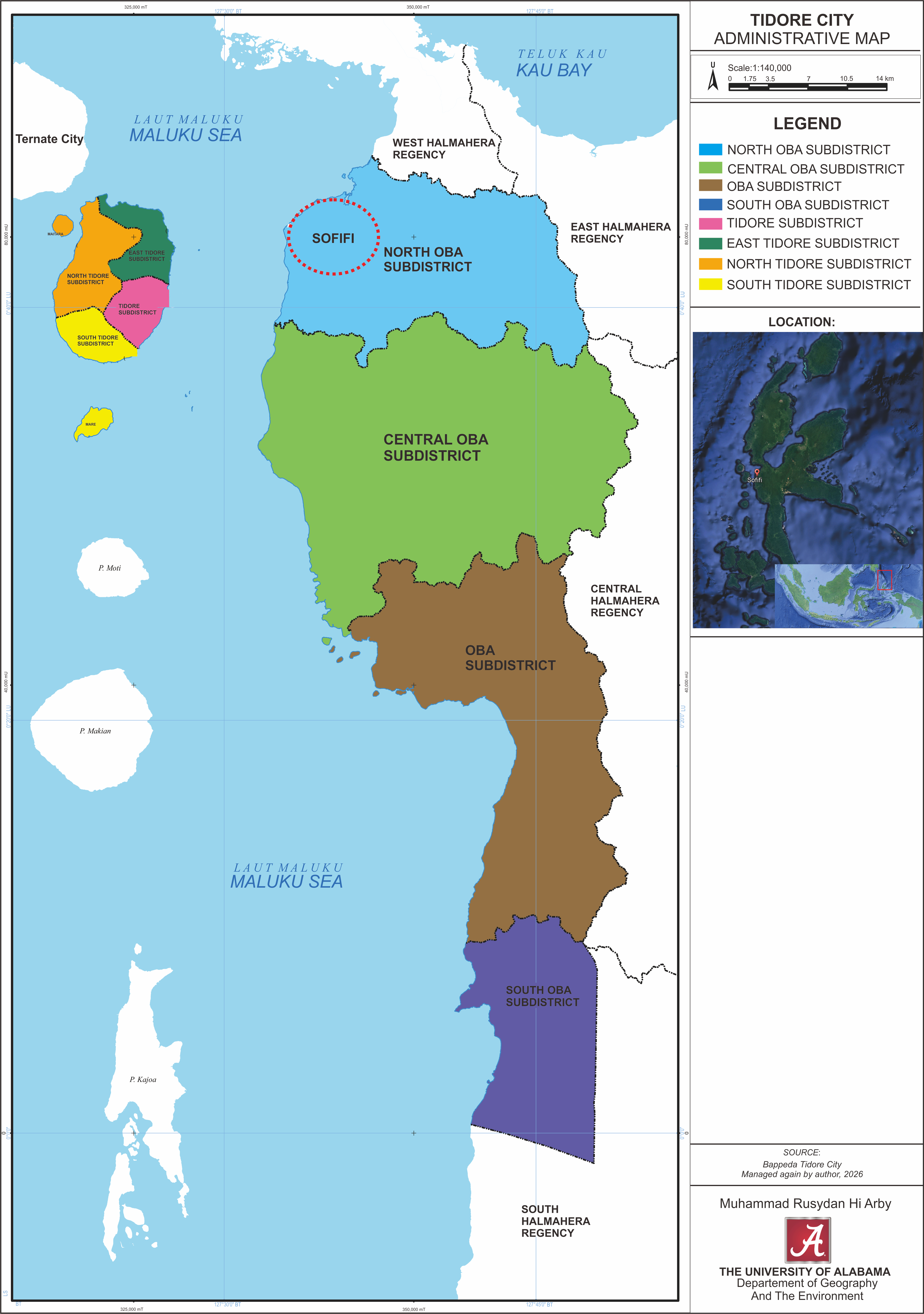
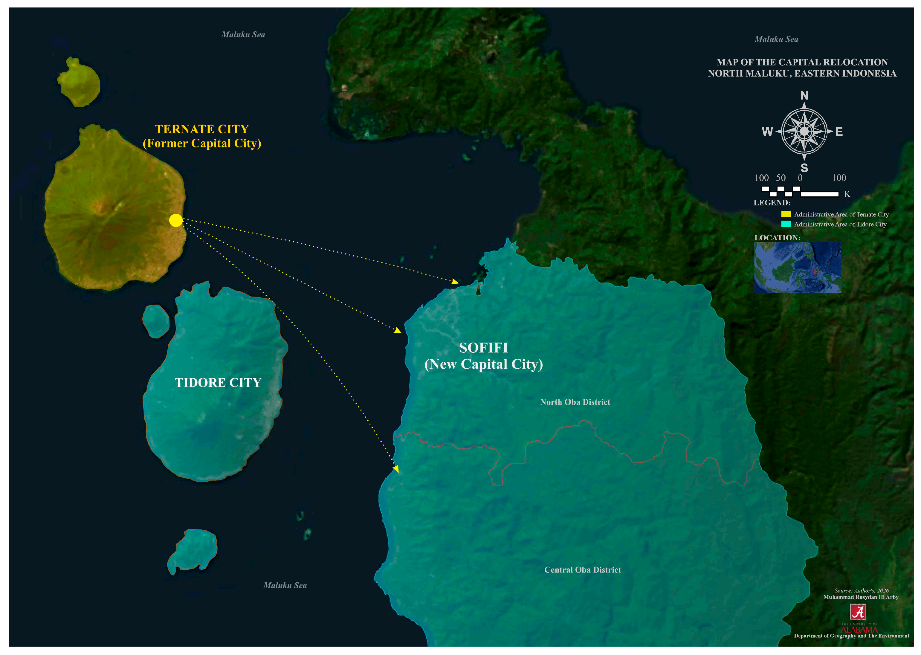
Conventional explanations of urban underdevelopment provide only a partial account of Sofifi’s trajectory. Unlike many lagging regional centers, Sofifi is not constrained by an unfavorable physical setting. The city occupies relatively flat coastal land on Halmahera Island and benefits from a strategic location between mainland Halmahera and Tidore Island. The geographic and administrative location of Sofifi within Tidore Islands City is shown in
Figure 1.
Nor has it been neglected by national policy, which has repeatedly identified it as a priority development area within broader regional development initiatives. Instead, Sofifi’s development appears to be shaped by the interaction of three interrelated structural conditions. First, the city possesses a relatively limited socio-economic base, restricting the diversity and intensity of urban activities that can be sustained locally. Second, infrastructure deficits and accessibility challenges continue to weaken its connections with surrounding settlements and regional economic networks. Third, governance arrangements remain complex due to overlapping authorities among the Government of North Maluku Province, the Government of Tidore Islands City, and the Sultanate of Tidore, which maintains customary claims over portions of the land on which Sofifi is located. Together, these conditions have shaped the opportunities and constraints through which Sofifi has attempted to develop as a provincial capital.
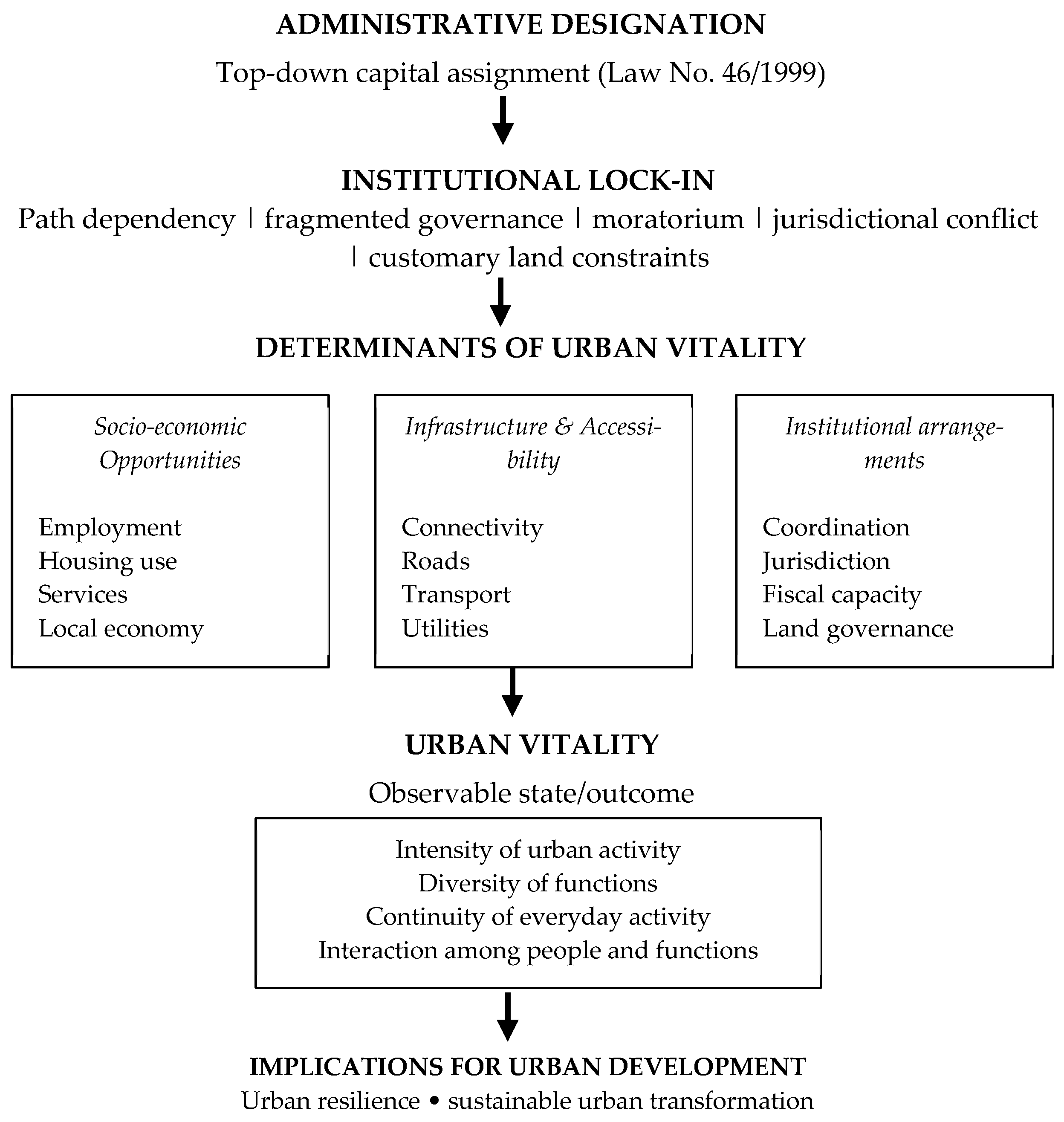
Understanding these dynamics requires an analytical framework capable of integrating socio-economic, spatial, and institutional dimensions of urban development. This study employs the concept of urban vitality as such a framework. Urban vitality is understood here as the observable condition of a city in which diverse, continuous, and interactive forms of social, economic, and spatial activity are sustained over time. This study distinguishes between urban vitality itself and the conditions that enable or constrain it. Socio-economic opportunities, infrastructure and accessibility, and institutional arrangements are therefore treated as key determinants of urban vitality rather than as vitality itself. Their interaction shapes the capacity of a city to support the intensity, diversity, continuity, and interaction of everyday urban activities. In this sense, the “capacity” perspective is retained as an analytical bridge between underlying conditions and the observable state of vitality, rather than as a substitute for the state or outcome itself.
This interpretation builds upon a long tradition of urban scholarship that conceptualizes urban vitality through the intensity, diversity, continuity, and interaction of everyday urban life. Classical contributions emphasize mixed activities, social interaction, and spatial connectivity as important characteristics of vibrant urban environments [
5,
6]. More recent studies further demonstrate that observed levels of urban vitality vary in relation to land-use diversity, accessibility, activity density, and broader environmental conditions [
7,
8]. These studies support an analytical distinction between urban vitality as an observable state of urban functioning and the underlying conditions that influence its emergence and persistence. From this perspective, socio-economic opportunities, infrastructure and accessibility, and institutional arrangements are treated in this study as determinants that enable or constrain urban vitality rather than as constituent dimensions of vitality itself. This distinction is particularly important for relocated capitals, where physical investment and administrative functions may be present without necessarily generating sustained and diverse patterns of everyday urban activity.
The broader literature on capital city relocation has examined a wide range of cases, including Brasília, Canberra, Putrajaya, and Naypyidaw, identifying political commitment, fiscal capacity, and spatial integration as critical determinants of successful capital development [
1,
3,
9,
10]. However, relatively little attention has been devoted to cases in which relocated capitals lack administrative autonomy and remain embedded within broader territorial jurisdictions governed by other local authorities. In such arrangements, authority over planning, land administration, infrastructure provision, and public services is divided among multiple governmental institutions, leaving no single authority with comprehensive responsibility for the capital’s development. Consequently, the priorities of local governments may not always align with the functional and developmental needs of the provincial capital.
This issue is particularly relevant in Indonesia because seven of the country’s thirty-eight provincial capitals lack autonomous municipal status. They include Mamuju in West Sulawesi, Tanjung Selor in North Kalimantan, and Manokwari in West Papua. Rather than representing an isolated administrative anomaly, these cases constitute an important yet understudied feature of Indonesia’s post-decentralization territorial structure. Among them, Sofifi represents both the oldest and one of the most institutionally complex examples. Consequently, examining Sofifi provides an opportunity not only to understand the challenges facing North Maluku’s capital but also to generate broader insights into the governance and development of non-autonomous provincial capitals throughout Indonesia.
Against this backdrop, this study pursues three interrelated objectives. First, it assesses urban vitality in Sofifi based on measurable socio-economic indicators, including employment opportunities, housing availability, educational access, tourism activity, and the affordability of essential services. Second, it evaluates infrastructure provision and accessibility, including transportation networks and public-service coverage, and examines how these conditions influence Sofifi’s capacity to function as a provincial capital. Third, it evaluates the institutional and land-related conditions shaping Sofifi’s development, with particular attention to the opportunities and constraints arising from overlapping authorities among provincial institutions, local government, and customary governance structures.
To achieve these objectives, the study adopts a mixed-methods case study approach integrating spatial analysis of land-use change using GIS and remote sensing, qualitative investigation of governance arrangements and stakeholder perspectives through semi-structured interviews and document analysis, and comparative assessment of other non-autonomous provincial capitals in Indonesia. Following [
11], Sofifi is treated as a critical case because the conditions under examination are present in particularly pronounced and analytically revealing forms. The research employs a single embedded case study design consisting of three analytical subunits corresponding to the study’s objectives.
This article contributes at three levels. Empirically, it provides an integrated assessment of urban vitality in Sofifi based on socio-economic, spatial, and institutional evidence. Theoretically, it distinguishes urban vitality as an observable state of urban functioning from the socio-economic, infrastructural, and institutional conditions that enable or constrain it, while demonstrating how institutional lock-in can limit the translation of state-led investment into sustained urban activity. This perspective also connects urban vitality to the broader challenge of urban resilience: although the two concepts are not equivalent, the ability to sustain diverse economic activities, accessible infrastructure, continuous urban functions, and coordinated governance provides an important foundation for cities to adapt and maintain their functions over time. In practice, the study offers evidence-based insights into the governance and spatial planning of non-autonomous provincial capitals and highlights the importance of institutional coordination for sustainable and resilient urban transformation in newly designated capitals.
2. Theoretical Background
The theoretical literature on capital city relocation emphasizes that the effectiveness of a newly designated capital depends not only on the transfer of administrative functions but also on the institutional, spatial, and socio-economic conditions that enable those functions to become embedded in everyday urban life [
1,
2]. Comparative experiences of capital relocation further demonstrate that administrative designation and physical investment alone are insufficient to generate sustained urban vitality [
2]. While some relocated capital cities have successfully evolved into vibrant political and economic centers, others have struggled to attract population, economic activity, and institutional consolidation despite substantial governmental investment and political commitment [
1,
3,
4].
The scholarly literature on capital city relocation identifies several conditions that distinguish successful relocation projects from those that stagnate political coherence or sustain elite commitments over time: fiscal autonomy that insulates the projects from budgetary fluctuation, spatial integration with the surrounding region, and institutional integration across levels of government. Schatz [
1] argues that the most consequential relocations are those driven by coherent state-building and nation-building imperatives, and Chai et al. [
9] show in their analysis of Putrajaya that dedicated, ring-fenced public funding insulated Malaysia’s federal administrative center from the fluctuations that have undermined comparable projects elsewhere. Cases from sub-Saharan Africa illustrate the limits of designation in the absence of these conditions. Mabogunje [
4] finds that Abuja achieved physical sophistication as an urban environment but failed to generate the regional linkages that would have embedded it within Nigeria’s broader pattern of national development. Mosha [
3] documents an even more direct parallel for the present study on Dodoma, designated as Tanzania’s capital in 1974 to replace Dar es Salaam, experienced four decades of underfunded, administratively fragmented, and politically inconsistent development, such that it still has not displaced the coastal city as the country’s functional center. Potts [
12] reports a similar trajectory in Lilongwe, Malawi, where growth concentrated narrowly in the government quarter despite substantial donor funding and political will. The Asian experience is more varied. Astana’s rapid growth was underwritten by Kazakhstan’s hydrocarbon revenues and concentrated presidential authority [
1], conditions that are not easily generalized, while Naypyidaw was deliberately isolated from Myanmar’s urban politics rather than designed to generate integrated national development [
13]. Indonesia’s own relocation of its national capital from Jakarta to Nusantara in East Kalimantan has attracted growing scholarly attention as a case of state-led spatial redistribution [
10,
14], but it differs fundamentally from the case examined here in both scale and institutional architecture. Nusantara is backed by a dedicated national authority with legal sovereignty over its territory, whereas the capital city (Sofifi) examined in this study lacks autonomous city status altogether. Across this literature, the conditions most reliably associated with successful relocation such as political coherence, fiscal autonomy, territorial sovereignty, and institutional integration, are precisely those that are absent or contested in the case of the vitality of Sofifi, the subject of this study.
The concept of urban vitality offers a complementary lens through which to evaluate what capital city designation alone fails to produce. Existing scholarship commonly associates urban vitality with the intensity, diversity, continuity, and interaction of people and activities in urban space. According to Jacobs [
5], as cited in [
15], urban vitality emerges from the dense and diverse mixing of land uses that sustains continuous pedestrian activity and social interaction. Yamu et al. [
6] extend this perspective through space syntax, demonstrating that the configurational properties of street networks shape pedestrian movement, social interaction, and land-use intensity. These perspectives are important because they distinguish the observable manifestations of vitality, such as sustained activity and social interaction, from spatial conditions, such as land-use diversity and network configuration, that help generate them. Urban vitality is therefore treated here primarily as a state of urban functioning rather than as the physical conditions that produce that state.
Subsequent empirical research has reinforced this distinction while demonstrating that urban vitality varies across spatial and temporal contexts. Xiao et al. [
8] show that observed vitality is closely associated with land-use diversity, activity density, and accessibility, indicating that these spatial characteristics can shape the intensity and distribution of urban activity. Similarly, Mouratidis [
16] argues that assessments of vitality should not rely solely on observable activity but should also consider residents’ subjective experience of livability. The authors of [
17] further demonstrate the multidimensional character of urban vitality by examining its economic, social, cultural, environmental, and spatial dimensions in relation to urban shrinkage. Their findings show that these dimensions respond differently to changing urban conditions, reinforcing the importance of distinguishing observed vitality outcomes from the diverse processes and conditions that shape them. Taken together, these studies suggest that urban vitality can be understood as an observable and experienced state of urban functioning, while land-use configuration, accessibility, and other characteristics of the urban environment operate as conditions that influence that state.
Beyond these spatial and experiential conditions, the present study argues that institutional arrangements constitute an important upstream determinant of urban vitality, particularly in planned or relocated capitals. Ostrom [
18] demonstrates that the capacity of collective systems to sustain adaptive and productive activity depends on governance arrangements capable of coordinating action, managing shared resources, and resolving conflicts. Applied to the urban context, this perspective suggests that fragmented authority can constrain the conditions under which diverse and sustained urban activities emerge. Studies of fragmented metropolitan governance similarly associate institutional fragmentation with weaker public-service provision and lower levels of investment [
19,
20]. Institutional arrangements are therefore not treated here as a manifestation of urban vitality itself. Rather, they shape the socio-economic and spatial conditions through which vitality can emerge and persist. This distinction is particularly relevant to Sofifi, where substantial physical investment and formal administrative functions coexist with fragmented governance and incomplete urban consolidation.
Indonesia’s post-Reformasi decentralization provides the structural backdrop against which this absence must be understood. Law No. 22 of 1999 and its subsequent revision opened the way for a rapid proliferation of new administrative units, more than three hundred new districts and cities within a decade, and an expansion of provinces from 27 to 38 in [
21]. The author of [
22] shows that this proliferation has frequently produced spatial polarization rather than equalization, with investment concentrating in already-advantaged centers while newly created peripheral units struggle to build the administrative and fiscal capacity that effective governance requires, and ref. [
20] find that the success of decentralization in generating local development depends heavily on pre-existing institutional capacity, such that units created in areas with weak administrative traditions tend to reproduce rather than transcend their prior governance deficits. Among the most structurally significant yet least examined consequences of this process is a category of provincial capitals that have never been granted autonomous city status. As of 2025, seven of Indonesia’s 38 provincial capitals remain administratively subordinate to the district or city government within which they are physically located. These are Sofifi in North Maluku, Mamuju in West Sulawesi, Manokwari in West Papua, Tanjung Selor in North Kalimantan, Merauke in South Papua, Nabire in Central Papua, and Wamena in Highland Papua. This condition has persisted in part because of a national moratorium on the creation of new autonomous regions, introduced to limit the fiscal and administrative costs of further proliferation, which has effectively frozen these localities’ institutional status and foreclosed the pathway through which autonomous urban development might otherwise be pursued.
Comparison across three of these cases illuminates the structural pattern that this study identifies in Sofifi. Mamuju, established as the capital of West Sulawesi under Law No. 26 of 2004, illustrates the fiscal consequences of non-autonomous status within the same moratorium that constrains Sofifi. The proposals for an autonomous Kota Mamuju have been submitted repeatedly since 2019 without success, leaving the city without the fiscal instruments required to fund the infrastructure investment its administrative function demands [
18]. Tanjung Selor, capital of North Kalimantan, shares with Sofifi the distinction of having been built largely from scratch rather than elevated from an existing settlement, and its administrative position is, if anything, more constrained. It constitutes a single sub-district within Bulungan Regency, and its elevation to city status has been blocked by a requirement that any new city comprise at least four sub-districts, a threshold it has not yet met. Its functional dependence on the larger city of Tarakan mirrors, in structurally significant ways, Sofifi’s dependence on Ternate. Manokwari, capital of West Papua, presents a different profile. It has experienced substantial demographic growth since its designation, but this growth has produced unplanned settlement expansion rather than integrated urban development, indicating that the absence of autonomous governance can generate two distinct forms of urban dysfunction, the functional emptiness exhibited by Sofifi and Tanjung Selor, or the unplanned density exhibited by Manokwari [
20].
These cases collectively point toward a mechanism that this study terms institutional lock-in, drawing on path dependency theory [
23] and the fragmented governance framework introduced above [
24]. Institutional lock-in describes a condition in which an administrative status quo, once established, generates its own stabilizing incentives and resistances, such that departure from the existing arrangement becomes progressively more difficult over time, even where that arrangement is demonstrably suboptimal. In the context of non-autonomous provincial capitals, this mechanism operates through at least three channels. They include absence of autonomous fiscal authority prevents the capital from generating the investment revenue that would make urban development self-sustaining; jurisdictional fragmentation between provincial government, city or district government, and, in Sofifi’s case, customary governance authority. This produces a collective action problem in which no single actor holds both the mandate and the incentive to undertake the coordinating investments urban development requires; and the moratorium on new autonomous regions removes the institutional pathway through which lock-in might otherwise be resolved, rendering the status quo self-perpetuating absent an explicit national policy intervention. It is this condition, rather than any simple deficiency of resources or political will, that this study argues best explains the persistent gap between Sofifi’s administrative status and its urban vitality, examined empirically in the sections that follow.
Figure 2 summarizes the analytical framework adopted in this study, distinguishing the socio-economic, infrastructural, and institutional determinants of urban vitality from their observable manifestations in everyday urban functioning.
3. Study Area
North Maluku Province occupies the northern part of the Maluku Archipelago in eastern Indonesia, comprising eight regencies and two autonomous municipalities across more than 1000 islands. The province was established on 4 October 1999 under Law No. 46 of 1999 [
26], which simultaneously designated Sofifi as its permanent capital. Provincial administration nonetheless remained in Ternate, the region’s long-established urban center, until the formal relocation to Sofifi on 4 August 2010, a process that remains incomplete more than fifteen years later.
Sofifi lies on the western coast of Halmahera Island within the jurisdiction of Tidore Islands City, administratively situated in North Oba Sub-district (Kecamatan Oba Utara). The sub-district comprises thirteen villages and urban wards across 643.96 km
2, with population growing from 14,046 in 2010 to 19,552 in 2021 [
24]. Urban ward/Kelurahan Sofifi itself, hosting the provincial government complex, covers 35.00 km
2 with a 2021 population of 2498 (71 persons/km
2), a notably low density. Official growth projections place the sub-district’s population at 23,953 by 2026, reflecting a 4.14% annual growth rate between 2020 and 2021, more than double the provincial rate of 1.60% [
24], though this figure should be read cautiously given an irregular jump in Tidore Islands City’s recorded population over the same period, likely reflecting administrative revision rather than organic growth alone. The spatial relationship between Sofifi, Ternate, and Tidore within the capital relocation context is illustrated in
Figure 3.
This study’s principal spatial unit of analysis is the formally designated Sofifi Urban Area (Kawasan Perkotaan Sofifi), spanning 3508.18 ha across eleven villages and two urban wards, including Sofifi, Guraping, Galala, Bukit Durian, and Akekolano [
26]. This narrower planning area, rather than the full sub-district, is used because the sub-district’s eastern and northern portions are predominantly steep forested terrain excluded from urban development: while most of the planning area sits at 2.5–40 m elevation with slopes below 15%, roughly 24.25% of the wider sub-district exceeds 40% slope. This topography has confined urban expansion to a narrow coastal corridor.
Land use within the Sofifi Urban Area remains dominated by non-urban categories. Plantation land constitutes 21.90% of the planning area, the largest single category, while built-up zones for government, trade, and services occupy a considerably smaller share; tourism-designated land accounts for only 0.21%, and protected areas, including northern mangroves, cover 18.03% in [
27]. The spatial plan further concentrates governmental, commercial, and transportation functions in urban ward/Kelurahan Sofifi specifically, while allocating healthcare and tourism to neighboring Guraping and higher education to Akekolano, a functional distribution across settlements rather than within a single mixed-use core, with direct implications for the land-use diversity central to urban vitality.
This administrative origin is visible in the area’s economic structure. Government consumption expenditure dominated North Oba’s GRDP throughout 2010–2021, rising from 72.1% to a peak of 92.6% in 2015 before settling at 85.2% [
26], with household consumption, private investment, and net exports together accounting for only a marginal share. This pattern is reinforced by civil servants’ commuting behavior: infrastructure planning assessments estimated that roughly 4000 provincial and ministerial civil servants remained Ternate-based through the early 2020s, commuting daily by sea despite a relocation target originally set for 2019–2021 that no subsequent evidence indicates was achieved [
26]. Ternate consequently continues to dominate regional trade and higher-order urban functions.
This pattern sits awkwardly alongside North Maluku’s broader economic trajectory. Provincial growth, driven by nickel mining in Central Halmahera, rose from 7.92% in 2017 to 39.10% in 2025, the highest of any Indonesian province [
28], yet Tidore Islands City itself grew only 6.40% in 2024 [
28], and the Sofifi planning area’s economic structure remains government-dependent. This divergence between rapid provincial growth and limited capital-city development is the empirical puzzle this study addresses, underscoring why urban vitality must be assessed as a spatially specific condition rather than inferred from aggregate provincial figures.
A final distinguishing feature is institutional. Sofifi hosts the provincial government but lacks autonomous municipal status, remaining administratively part of Tidore Islands City; the area is governed by the Tidore Islands City Government rather than an authority accountable to the province it serves. The Sultanate of Tidore, asserting customary authority over the area, has consistently opposed its separation into an autonomous municipality. Combined with the national moratorium on new autonomous regions, this overlapping authority has produced the institutional lock-in that this study identifies as the primary structural barrier to Sofifi’s urban vitality.
Building on this context, the study employs a mixed-methods case study design integrating spatial analysis, qualitative inquiry, and comparative analysis. A mixed-methods approach is necessary because the research objectives require both empirical measurement of observable spatial conditions and interpretive examination of governance arrangements that spatial data alone cannot capture. Following [
11], Sofifi is treated as a single embedded critical case [
29] with three analytical subunits corresponding to the three research objectives: a socio-economic subunit assessing measurable indicators of urban vitality, a spatial subunit evaluating land use and infrastructure through GIS analysis, and an institutional subunit examining governance constraints through document analysis.
4. Methods
4.1. Research Design
Following this description of the study area, this study employs a mixed-methods case study design integrating spatial analysis, qualitative inquiry, and comparative analysis to assess urban vitality in Sofifi across its socio-economic, infrastructural, and institutional dimensions. A mixed-methods approach is adopted because the research objectives require both the empirical measurement of observable spatial conditions and the interpretive examination of governance arrangements and institutional constraints that spatial data alone cannot capture. The case study design follows [
11] in treating Sofifi as a single embedded critical case [
29] with three analytical subunits corresponding directly to the three research objectives: the socio-economic subunit assessing urban vitality through measurable indicators; the spatial and infrastructural subunit evaluating land use transformation and infrastructure provision through GIS analysis; and the institutional subunit investigating governance constraints and customary land-related impediments through document analysis and secondary literature.
4.2. Data Sets
The empirical basis of this study combines primary and secondary data sources collected at three spatial scales: the village level (urban ward/Kelurahan Sofifi), the sub-district level (Oba Utara), and the city level (Tidore Islands City).
Table 1 summarizes the principal data sets used in the spatial component of the analysis.
Beyond these spatial data sets, the study draws on socio-economic statistics published in the Tidore Islands City statistical yearbook [
28] and the Oba Utara sub-district statistical yearbook, an infrastructure planning assessment commissioned by the city government [
23], and contemporaneous government communications and local news reporting through early 2026, the latter providing a level of temporal currency that published statistical yearbooks, which typically lag two to three years behind the present, cannot offer on their own. Primary qualitative data were gathered through preliminary semi-structured interviews with key informants, including government officials and institutional stakeholders directly involved in Sofifi’s governance and spatial development, conducted at the early stage of the broader fieldwork programme of which this article forms a part.
4.3. Spatial Analysis and Land Use Classification
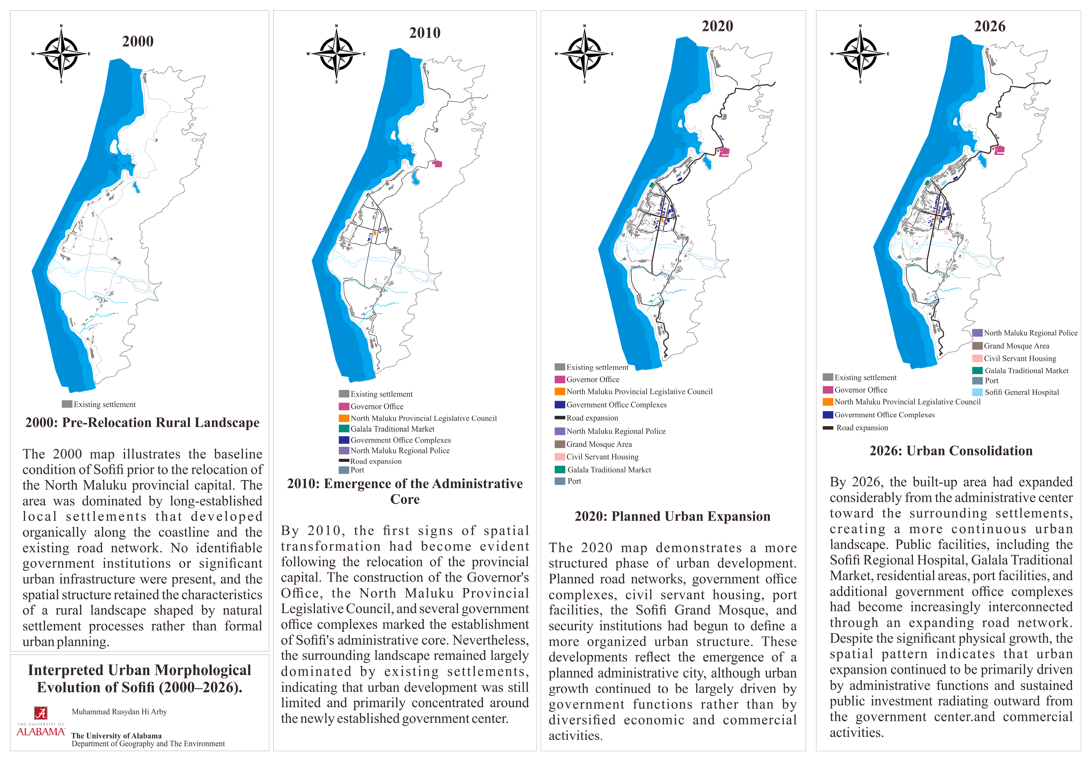
Spatial analysis in this study examines land use and land cover change in the designated Sofifi planning area across three time points: 2013, shortly after the formal inauguration of the provincial capital in 2010; 2019, reflecting roughly a decade of institutional consolidation; and 2026, the most recent point for which suitable cloud-free imagery was available at the time of analysis. Satellite imagery for each time point was processed and classified using ArcGIS Pro 3.3.0 through a supervised classification approach ArcGIS t, with four land cover categories defined for analysis: water body, forest, bare land, and built-up area. Training samples for each category were selected through visual interpretation of reference imagery and verified against existing land use records from the Tidore Islands City spatial planning documents. Comparison of the three classified images was conducted to detect and quantify land cover change over the study period, generating both spatial outputs, in the form of classified land cover maps, and quantitative outputs, in the form of the percentage composition of each land cover category at each time point. In addition, Google Earth Pro imagery was used to conduct an interpretive morphological analysis of Sofifi’s urban spatial evolution across four time points—2000, 2010, 2020, and 2026—tracing the sequential emergence of government infrastructure, public facilities, and settlement patterns prior to and following the capital’s formal designation. The resulting classified maps, change detection statistics, and morphological interpretation collectively constitute the empirical basis for the spatial findings presented in
Section 5.2 of this article.
4.4. Qualitative and Document Analysis
Qualitative data for this study were collected through three complementary techniques. Semi-structured interviews were conducted with key informants, including officials from the North Maluku Provincial Government, the Tidore Islands City Government, representatives of the Sultanate of Tidore, academics, community leaders, and Sofifi residents. Field observations focused on infrastructure conditions, mobility, public space use, and economic activity. Document analysis covered the Tidore Islands City Regional Spatial Plan (RTRW), the Sofifi urban area detailed spatial plan (RDTR), the city’s infrastructure planning assessment (RPIP), BPS statistical reports, and historical records on Sofifi’s designation as provincial capital, supplemented by contemporaneous government communications and local news reporting where published statistics were unavailable or insufficiently current. Thematic analysis of the resulting material followed within-case analysis and cross-case synthesis techniques [
11] (Yin, 2018), allowing patterns within Sofifi to be examined in depth before being situated within the broader comparative analysis presented in
Section 5.4. Following [
11] logic of analytical generalization, the comparative cases were selected purposively rather than as a statistically representative sample. Mamuju (West Sulawesi), Tanjung Selor (North Kalimantan), and Manokwari (West Papua) were selected because they provide institutionally comparable cases in which provincial-capital functions operate within broader local administrative jurisdictions rather than through separate autonomous municipal governments. This shared institutional condition provides a common basis for examining how differences in governance arrangements, geographic context, external dependence, and development trajectories influence the consolidation of capital-city functions. At the same time, variation among the three cases allows the analysis to assess whether the institutional constraints identified in Sofifi are specific to its local context or reflect a broader mechanism relevant to similarly governed provincial capitals. The comparison therefore aims at analytical rather than statistical generalization. The four cases are compared across five variables: year of designation, current administrative status, constraints on autonomous region formation, dependence on neighboring cities, and the resulting profile of urban vitality.
5. Findings
5.1. Socio-Economic Indicators of Urban Vitality in Sofifi
Assessing urban vitality in Sofifi through measurable socio-economic indicators requires combining evidence at three spatial scales: the village level, where data on urban ward/Kelurahan Sofifi itself are available; the sub-district level (Oba Utara), which provides the most consistent disaggregated economic time series; and the city level (Tidore Islands City), which offers sectoral detail not available at finer scales. Where official statistical publications are silent or incomplete, this section additionally draws on contemporaneous government communications and local news reporting through early 2026, providing a level of temporal currency that published statistical yearbooks, typically lagging 2 to 3 years, cannot offer.
Disaggregated employment data by economic sector are available only at the city level. In 2024, the services sector accounted for the largest share of Tidore Islands City’s working population at 44.7 percent (27,476 of 61,465 workers), followed by manufacturing at 28.7 percent and agriculture at 26.6 percent [
27]. Within this broad services category, however, the structure of employment in Oba Utara Sub-district specifically appears considerably more concentrated in public administration than the city-wide average suggests. Gross Regional Domestic Product data for Oba Utara indicate that government consumption expenditure accounted for between 72.1 and 92.6 percent of total sub-district output across the 2010–2021 period, settling at 85.2 percent by 2021 [
23], a far higher concentration than the 38.5 percent share that public administration occupied in the broader city economy in 2024. This interpretation is reinforced by an infrastructure planning assessment indicating that approximately 4000 civil servants formally assigned to provincial and ministerial offices in Sofifi remained resident in Ternate as of the early 2020s, continuing to commute by sea rather than relocating [
23]. This pattern suggests that a substantial share of the labor formally counted as employed “in” Sofifi does not, in practice, generate local consumption, residential demand, or service-sector activity within the city itself.
Housing provision in Sofifi reveals an important paradox for understanding urban vitality. The principal constraint is not the availability of housing but its persistent underutilization. As of early 2025, the provincial government reported 584 government-owned residential units (
rumah dinas) and 99 dormitory-style apartment units (
rusun), with an additional 44 units completed in February 2025. In addition, the Ministry of Public Works and Housing allocated approximately IDR 530 billion in 2023 to construct residential towers for medical personnel, civil servants, and security forces [
30,
31]. These figures indicate that housing supply has not been the principal constraint on the relocation process.
The challenge instead lies in housing occupancy. Administrative inspections conducted between January and June 2025 found that many allocated government housing units remained effectively vacant. Although civil servants had been assigned official residences in Sofifi, many continued to reside in Ternate and treated the housing allocation largely as an administrative formality. In several documented cases, the allocated units were occupied by friends or associates of the assignee, while the assigned civil servant never stayed overnight [
32,
33].
Official attendance records reinforce this pattern. Although approximately 580 civil servants were formally registered as residents of government housing in Sofifi, only around 300 were present during a routine morning assembly. As of January 2026, the situation remained largely unchanged. Civil servants without government housing continued either to rent private accommodation or commute daily from Ternate, while many officially allocated housing units remained vacant [
34].
This persistent mismatch between housing provision and actual occupancy provides clear evidence of the institutional lock-in mechanism discussed in
Section 2. Although substantial public investment has expanded residential infrastructure, it has not produced a corresponding increase in the resident population. Weak enforcement mechanisms, together with the continued social and practical dependence of civil servants on Ternate, have prevented available housing from fulfilling its intended role in supporting the capital relocation process.
Educational facilities within Tidore Islands City are concentrated unevenly across sub-districts, with Tidore Sub-district, the city’s historical core, recording the highest number of teachers and the largest student enrollment at the primary level in the 2024/2025 academic year [
28]. Within the planning hierarchy established for the Sofifi urban area, higher education and broader social services have been formally designated to Desa Akekolano rather than to urban ward/Kelurahan Sofifi itself, while Sofifi’s own designated function is restricted to government administration, commerce, and transportation [
26].
This designed functional separation has been partially reinforced by recent national investment: in 2025, the Ministry of Public Works renovated a former narcotics rehabilitation facility (IPWL) in Desa Akekolano to serve as a Sekolah Rakyat (People’s School) at the senior secondary level, one of only two such facilities established in North Maluku Province and one of 63 completed nationally in the program’s first phase [
34]. While this investment expands the educational base of the broader planning area, it reinforces rather than reverses the spatial logic under which higher-order educational functions are sited in villages adjacent to, rather than within, the administrative core, a pattern with direct implications for the land use diversity that ref. [
15] identifies as constitutive of urban vitality.
Tourism indicators reveal a pattern that initially appears counterintuitive but is consistent with the broader argument of this study once interpreted carefully. Oba Utara Sub-district recorded the highest number of hotels and accommodation establishments of any sub-district in Tidore Islands City in 2024, with 16 of the city’s 27 total establishments, and the highest number of restaurants, with 50 of an estimated 76 city-wide [
28]. At the same time, the designated land use allocation for tourism within the Sofifi planning area itself amounts to only 0.21 percent of total planning area, the smallest allocation of any major land use category, and the number of formally registered tourism attractions in the sub-district was only two as of 2022 [
26,
28].
Locally reported visitor numbers help reconcile this apparent contradiction. The Guraping mangrove forest, the area’s most established attraction, drew an estimated 90 to 100 visitors per day under normal conditions, rising to 300 to 400 per day during the 2022 Eid al-Fitr holiday period [
35], figures consistent with a small, locally oriented recreational destination rather than a tourism economy generating sustained outside demand. Several smaller beach destinations, including Pantai Muara Oba and Pantai Doe Masure, have likewise been documented in recent local media coverage and travel listings, suggesting modest organic growth in informal tourism infrastructure since 2022 [
36]. The concentration of hotels and restaurants in Oba Utara is nonetheless more plausibly explained by demand from government officials, visiting delegations, and contractors engaged in the ongoing construction of administrative infrastructure than by tourism in the conventional sense, a pattern of demand that is structurally dependent on continued government presence and investment rather than on the diversified, self-sustaining economic activity associated with urban vitality in the Jacobsian sense.
Healthcare provision in the Sofifi planning area includes RSUD Sofifi, a Class D general hospital owned by the North Maluku Provincial Government and operational since 2016, together with a provincial psychiatric hospital established in 2020 and at least one inpatient community health center (puskesmas) [
37]. Consistent with the broader spatial pattern described above, both hospitals are located not in urban ward/Kelurahan Sofifi itself but in neighboring urban ward/Kelurahan Guraping, to which healthcare services have been formally allocated under the city’s spatial plan [
26]. Despite recent recognition, including a 2024 public service award and a ministerial visit in 2025, contemporaneous reporting has also described persistent constraints, including a stalled, debt-financed regional hospital expansion project reportedly left incomplete [
38]. The presence of functioning hospital infrastructure indicates that the area is not without essential services in the narrow sense; however, its concentration in Guraping rather than in the administrative core, combined with reported implementation difficulties in expanding capacity, is consistent with the broader pattern of functionally dispersed and incompletely resourced urban infrastructure that characterizes the wider planning area. Market infrastructure across the city remained stable at 14 markets between 2021 and 2024, with no sub-district-specific breakdown available in published statistics [
28].
Taken together, these five indicators describe a socio-economic base in Sofifi’s immediate vicinity that is substantially present in physical terms but only partially activated in functional terms. Government consumption dominates the local economy at a level (72–93 percent of sub-district GRDP) far exceeding even the already disproportionate share recorded at the city scale. Housing, hospital, and school infrastructure have all received substantial recent investment, yet each is undermined by a distinct form of incomplete activation: housing units stand vacant despite formal assignment, the general hospital is sited apart from the administrative core and has experienced a stalled expansion, and higher-order educational functions remain concentrated in a neighboring village rather than integrated with government offices. Even tourism and hospitality infrastructure, superficially abundant by sub-district standards, is better explained as a derivative of administrative activity than as evidence of organic urban vitality. These patterns are consistent with the institutional lock-in mechanism introduced in
Section 2: a designated capital whose administrative function has attracted substantial physical investment, but whose underlying jurisdictional, fiscal, and enforcement constraints have prevented that investment from consolidating into the diversified, fully inhabited, self-sustaining socio-economic base associated with urban vitality.
5.2. Infrastructure and Accessibility
Having established the socio-economic dimension of urban vitality in Sofifi, this section turns to the spatial and infrastructural conditions that shape, and are shaped by, that socio-economic profile. Land use and land cover classification of the Sofifi planning area at three time points, 2013, 2019, and 2026, provides the empirical basis for assessing the physical expansion of the built environment, while infrastructure data on roads, electricity, and water supply provide a complementary assessment of accessibility and service provision.
Prior to the quantitative land cover analysis,
Figure 4 provides an interpretive overview of Sofifi’s urban morphological evolution based on visual interpretation and manual on-screen digitization of multi-temporal Google Earth Pro imagery. Rather than serving as a scale-accurate cartographic representation, the figure illustrates the sequential spatial transformation of the planning area between 2000 and 2026. Across all four periods, urban development remained predominantly driven by administrative functions and sustained public investment, rather than by diversified economic activities, a pattern further quantified by the subsequent land cover analysis.
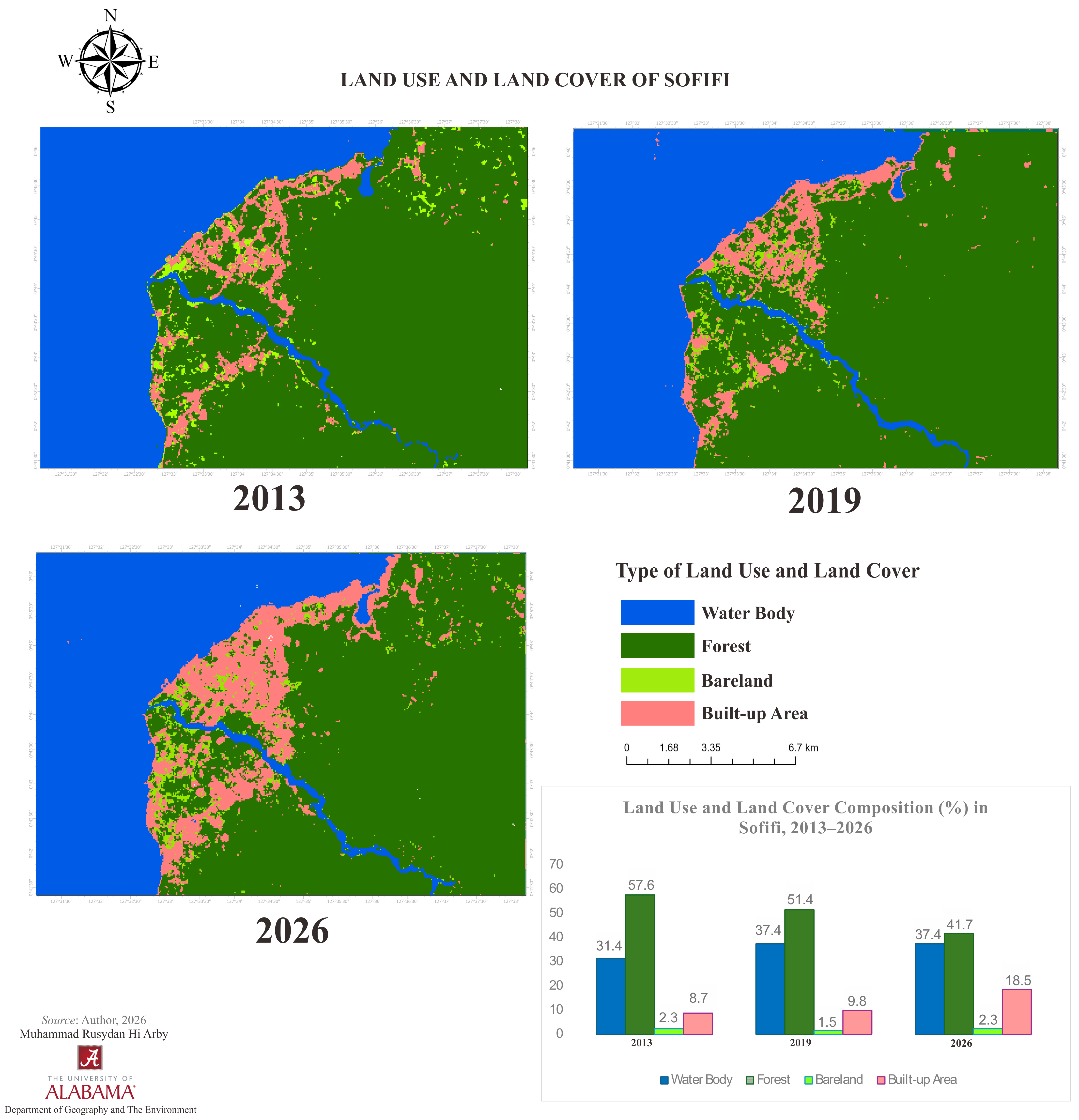
The classified land cover maps reveal a consistent pattern of coastal built-up expansion over the thirteen-year study period (
Figure 5). Built-up area increased from 8.7 percent of the classified area in 2013 to 9.8 percent in 2019 and 18.5 percent in 2026, very nearly doubling between 2019 and 2026 alone. This expansion has been concentrated almost entirely along the western coastal strip, where the provincial government complex and associated settlement are located, rather than distributed across the wider planning area. Forest cover declined correspondingly, from 57.6 percent in 2013 to 51.4 percent in 2019 and 41.7 percent in 2026, a reduction of nearly sixteen percentage points over the full period. Water body and bareland categories remained comparatively stable throughout, at approximately 31 to 37 percent and 1.5 to 2.3 percent, respectively, indicating that the observed change has been driven specifically by the conversion of forest to built-up area rather than by hydrological or geomorphological shifts. The acceleration of built-up expansion after 2019 is consistent with the period of intensified government investment documented in
Section 5.1, including the housing, hospital, and school construction projects undertaken between 2022 and 2025. The key socio-economic indicators across these dimensions are summarized in
Table 2.
Despite this expansion, the spatial pattern of built-up growth has been narrowing and linear rather than consolidated, a finding that bears directly on the land use mix and pedestrian-scale connectivity that constitute the spatial dimension of urban vitality discussed in
Section 2. Built-up area has extended along the coastal road corridor without developing the cross-cutting street network or block structure associated with a functionally integrated urban core. This pattern is consistent with the official spatial plan’s allocation of governmental, commercial, and transportation unctions specifically to urban ward/Kelurahan Sofifi while healthcare and tourism functions are sited in Guraping and higher education in Akekolano (
Section 5.1): rather than a single urban core whose built form supports diverse, overlapping land uses, the classified imagery shows a thin ribbon of development connecting functionally specialized nodes. The spatial distribution and changing composition of land use and land cover in Sofifi between 2013 and 2026 are presented in
Figure 5.
Road infrastructure within the designated planning area totals 37.686 km, comprising 34.921 km of national road, 0.500 km of provincial road, and 2.265 km of city road, the latter forming the Trans-Halmahera corridor that connects Sofifi’s coastal settlements to the rest of the island [
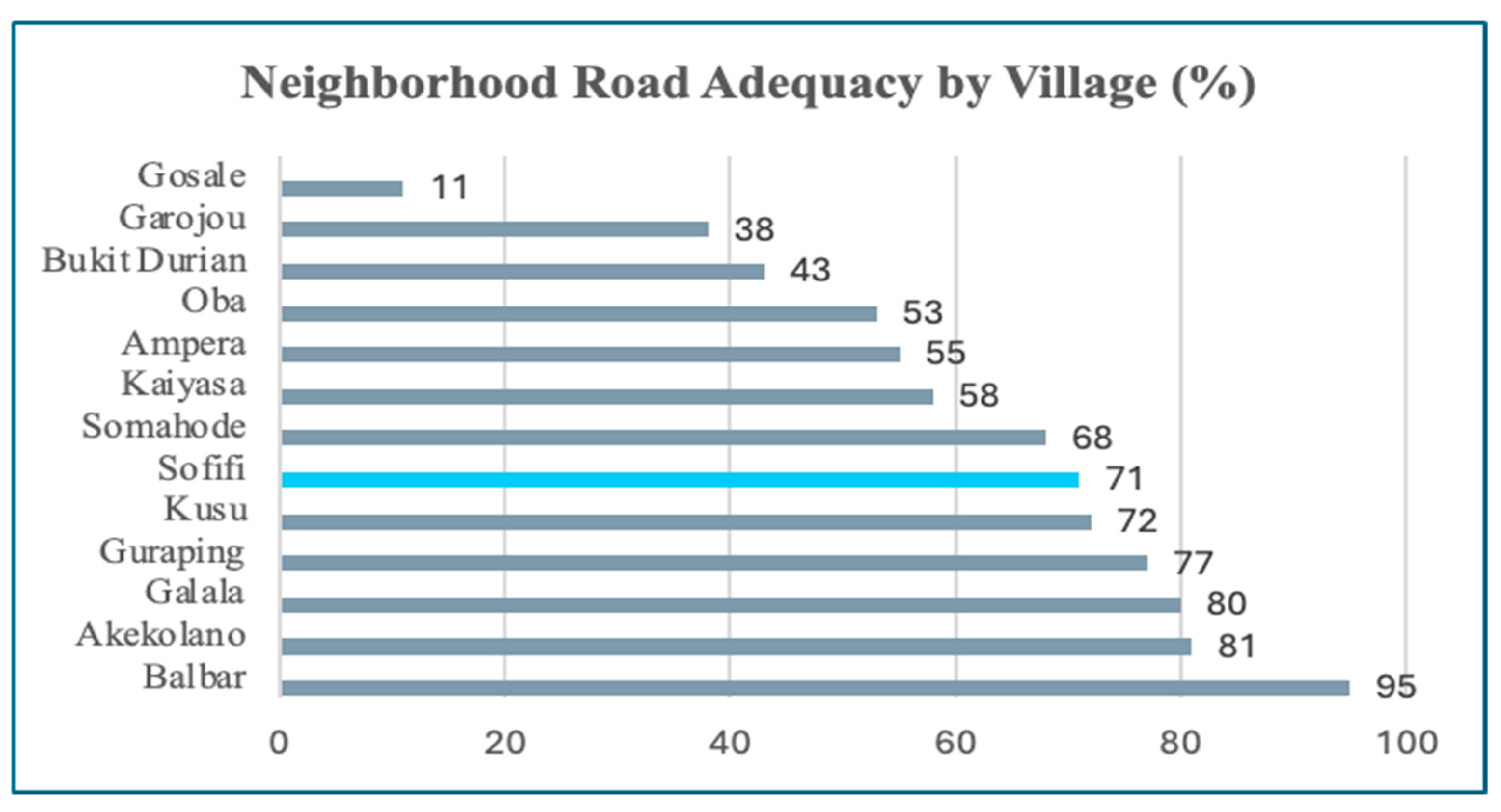
23]. The surface condition of this primary network is comparatively favorable, with 76.1 percent classified as good, 6.7 percent moderate, 8.4 percent damaged, and 8.6 percent severely damaged. Neighborhood-level Road infrastructure, which determines accessibility within individual villages rather than between them, presents a markedly more uneven picture. Drawing on a 2017 baseline survey of road conditions relative to technical standards, neighborhood road adequacy ranged from 95 percent in Desa Balbar to as low as 11 percent in Desa Gosale, with urban ward/Kelurahan Sofifi itself recording 71 percent adequacy, a middle-ranking position among the area’s thirteen villages and urban ward/kelurahan [
23]. This disparity indicates that infrastructure investment, even where it has occurred, has not produced uniform accessibility across the planning area, and that Sofifi’s own neighborhood-level connectivity, while better than the area’s least-served villages, remains short of full compliance with technical standards more than a decade after the capital’s inauguration. Public transportation within the urban area continues to rely on chartered vehicles and informal motorized rickshaws (bentor) rather than a scheduled, formal public transit system [
23], a further indicator of incomplete urban service provision. The variation in neighborhood road adequacy across villages in the Sofifi planning area is shown in
Figure 6.
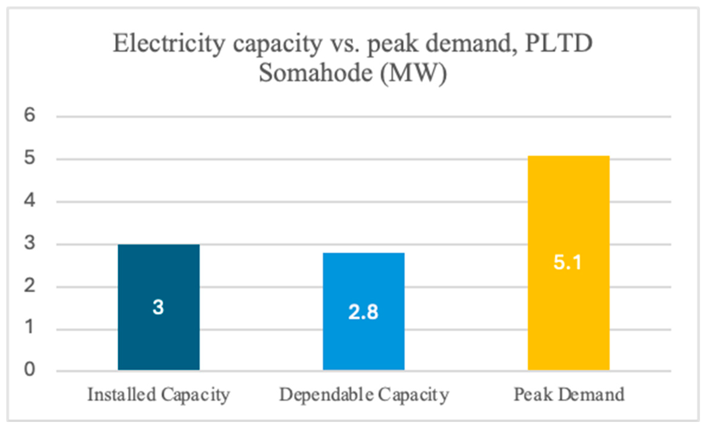
Electricity supply presents a more acute constraint. The area’s primary generation source, the Somahode diesel power plant (PLTD Somahode), has an installed capacity of 3.0 megawatts but a dependable capacity of only 2.8 megawatts, against a recorded peak demand of 5.1 megawatts [
26]. This indicates a structural generation deficit of approximately 2.3 megawatts at peak demand, a gap that existing renewable energy initiatives, including planned solar and coconut-husk biomass generation, had not yet closed as of the most recent planning assessment reviewed. Water supply is drawn from several small-capacity sources, including the Oba River (35 L per s), Guraping Bay (150 L per s, the largest single source), the Ake Kolano well (50 L per s), and two water treatment installations at Bukit Durian and Kaiyasa (10 L per s each), with several of these listed as planned upgrades rather than installations already operating at stated capacity [
26]. Telecommunications infrastructure likewise remains incomplete: the spatial plan identifies a specific zone within the urban core still requiring additional cellular base station capacity, notwithstanding an existing fiber optic and base station network across the wider planning area.
Taken together, the infrastructure evidence presented in this section indicates that Sofifi’s accessibility and service provision, like its socio-economic base examined, are best characterized as partially developed and unevenly distributed rather than wholly absent. The primary road network connecting Sofifi to the rest of Halmahera is in relatively good condition, and the built-up area has expanded substantially since 2019. At the same time, neighborhood-level road quality varies sharply across the planning area, electricity generation capacity falls short of peak demand by approximately 2.3 megawatts, public transportation remains informal, and the spatial pattern of built-up expansion has produced a narrow coastal corridor rather than a consolidated urban core. These findings are consistent with the institutional lock-in mechanism developed in
Section 2: infrastructure investment has been real and, in some respects, substantial, but its uneven distribution and the persistence of basic capacity constraints such as the electricity generation deficit suggest that investment has proceeded without the coordinated, sufficiently resourced planning authority that would be required to convert physical infrastructure into the spatial and service conditions associated with urban vitality.
5.3. Institutional Fragmentation and Land-Related Conflict
The socio-economic and infrastructural patterns documented in the preceding sections are best understood as downstream consequences of a more fundamental institutional condition: the overlapping and unresolved authority of three distinct actors over Sofifi’s territory and development. This section examines that condition directly, focusing on the jurisdictional relationship between the North Maluku Provincial Government, the Tidore Islands City Government, and the Sultanate of Tidore, and on the customary land claims that have constrained the area’s administrative consolidation.
Sofifi’s anomalous status stems from a basic mismatch between its political function and its legal status. The North Maluku Provincial Government has occupied and operated from Sofifi continuously since the 2010 inauguration, treating the locality as its permanent administrative seat in every practical sense. Yet Sofifi possesses no autonomous municipal government of its own; the territory on which the provincial complex sits remains formally part of Tidore Islands City, governed by a municipal administration whose seat lies on Tidore Island and whose own developmental priorities are not necessarily aligned with those of the province it hosts.
This arrangement means that decisions over land use permits, building approvals, and local infrastructure within Sofifi require coordination between two government bodies operating at different administrative levels, the province occupying the territory and the city legally governing it, with no single authority holding both the territorial jurisdiction and the developmental mandate required to plan and implement urban development unilaterally. As one key informant, a government official directly involved in the governance of Sofifi, explained, this asymmetry reflects a fundamental principle of Indonesian administrative law: “The provincial government is an extension of the central government, not a regional government. It does not own territory; territory belongs to districts and cities” (E.S., Interview, 2025). The implication is structurally significant: a provincial capital cannot exercise the land management and development powers that urban consolidation requires unless the locality is itself constituted as an autonomous city.
A proposal to resolve this mismatch by establishing Sofifi as an autonomous city has been raised periodically since shortly after the 2010 inauguration, but it has not advanced, for two compounding reasons. The first is national: Indonesia has maintained an effective moratorium on the creation of new autonomous regions (daerah otonomi baru, DOB) since 2014, introduced in response to concerns that the post-Reformasi proliferation of districts and cities, documented in
Section 2, had outpaced the fiscal and administrative capacity of the national government to support new units. This moratorium applies uniformly to proposals across Indonesia regardless of their individual merits, meaning that Sofifi’s case for autonomy, however administratively compelling, cannot proceed through ordinary legislative channels absent an explicit national policy exception. The second reason is local and more directly contested: the Sultanate of Tidore (Kesultanan Tidore), a customary institution that retains substantial social and political legitimacy in the region despite lacking formal governmental authority under Indonesian law, has consistently asserted that the land on which Sofifi sits forms part of its customary territory (tanah adat). Sultanate representatives and affiliated customary leaders have on multiple occasions publicly opposed proposals to separate Sofifi from Tidore Islands City, framing such separation as a diminution of the Sultanate’s historical territorial integrity rather than as a routine administrative adjustment. Informants in this study confirmed that these two barriers interact and reinforce one another:
“There are still obstacles related to the DOB, stemming from the conflict between the provincial government and the Tidore Islands City government; the city still invokes the customary rights of the Sultanate of Tidore, and to this day it has not been realized because of these unresolved internal problems. The DOB is a political process. It requires approval from the Tidore Islands City legislature, which represents the people of Tidore Islands City” (E.S., Interview, 2025). This account makes explicit what administrative documents leave implicit: the path to autonomy for Sofifi is blocked not by technical incapacity but by a political process in which the consent of the very body that stands to lose territory must be obtained before reform can proceed.
The practical consequence of this overlapping authority is most visible in the implementation gaps documented in
Section 5.1 and
Section 5.2. The stalled relocation of approximately 4000 civil servants from Ternate, the vacancy of government housing units despite substantial construction, and the incomplete expansion of hospital and electricity infrastructure each involve coordination across the same fragmented set of institutional actors: provincial agencies responsible for civil service relocation and housing allocation, city agencies responsible for permitting and local infrastructure, and, in matters touching land status, customary authority that neither government level can simply override. No single actor among these three has both the comprehensive mandate and the financial capacity to resolve the underlying land status question, and in the absence of that resolution, each investment—a housing tower, a hospital wing, a power plant upgrade-proceeds as an isolated project rather than as part of a coordinated development program with secure long-term land tenure.
The human cost of this impasse was captured vividly by one informant: “The DOB conflict for Sofifi city must be accelerated by the President and the Ministry of Home Affairs; this issue has been going on for too long. We cannot let Sofifi become a dead city, a place where provincial civil servants come to work and then return to Ternate or Tidore, leaving Sofifi empty with nothing to show for it. The state must step in and take over” (S.A., Interview, 2025). Another informant similarly emphasized the strategic importance of urgent action: “Sofifi has a strategic role to develop other areas in the regencies across the large island of Halmahera. But this strategic role cannot be seen only through the lens of politics and political decisions; it requires the provision of basic infrastructure to support the acceleration of Sofifi as a capital city” (A.A., Interview, 2025).
This configuration corresponds closely to the institutional lock-in mechanism introduced in
Section 2. The provincial government’s incentive to continue investing in Sofifi persists because the capital cannot simply be relocated again without enormous political and financial cost, yet its incentive to resolve the underlying jurisdictional dispute is comparatively weak because the province can continue to operate, however imperfectly, under the status quo. The city government’s incentive to support Sofifi’s full administrative consolidation is limited because doing so would mean ceding territory and the associated tax base and political constituency that Sofifi represents within Tidore Islands City.
The Sultanate’s incentive to resist separation is reinforced each time a development project proceeds without its explicit accommodation, reinforcing its position that the territory’s status remains contested. Each actor’s locally rational response to the others’ positions thus reproduces, rather than resolves, the fragmented arrangement, precisely the self-perpetuating dynamic that path dependency theory [
22] and fragmented governance frameworks [
18] predict will emerge absent an external intervention capable of realigning all three actors’ incentives simultaneously, a configuration of overlapping and uncoordinated authority summarized schematically in
Figure 7. Informants across this study converged on the view that such intervention is both necessary and overdue:
“This conflict must not be allowed to continue haunting Sofifi. Sofifi is the identity of North Maluku Province. The current governor must be more attentive, sitting together with the Mayor of Tidore and the Sultan of Tidore to resolve this issue, and it must be mediated by the Ministry of Home Affairs as the principal actor in advancing regional autonomy” (A.H., Interview, 2025). The gap between installed and dependable electricity capacity and peak demand at PLTD Somahode is illustrated in
Figure 7.
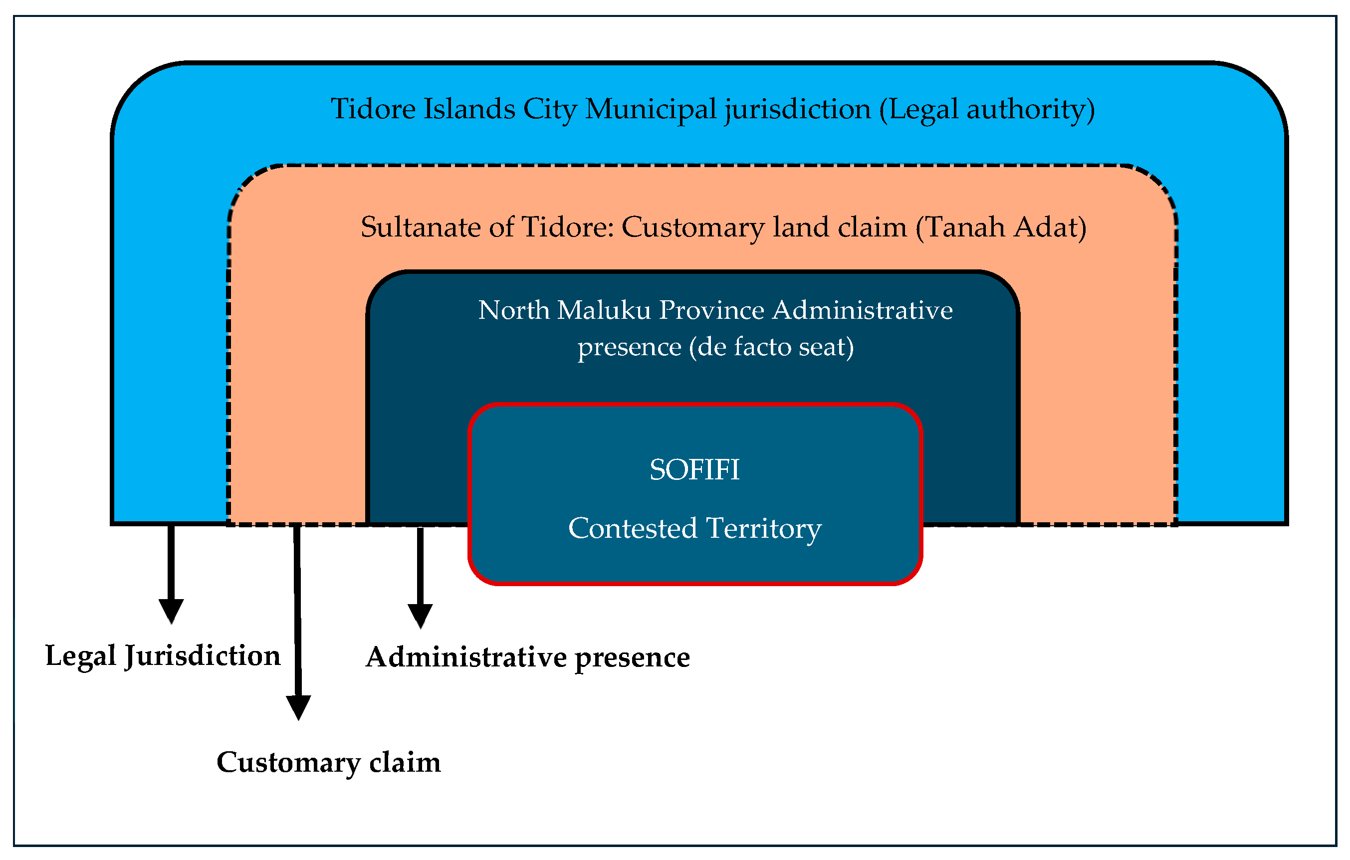
The overlapping legal, customary, and administrative claims shaping Sofifi’s institutional configuration are summarized in
Figure 8.
5.4. Sofifi in Comparative Perspective
The findings presented in
Section 5.1,
Section 5.2 and
Section 5.3 gain broader analytical significance when situated within the context of Indonesia’s other non-autonomous provincial capitals. As noted in
Section 2, Sofifi is one of seven provincial capitals in Indonesia that lack autonomous city status, a structural condition that this study argues is causally related to the patterns of constrained urban vitality documented above. Comparing Sofifi with three of the most analogous cases, Mamuju in West Sulawesi, Tanjung Selor in North Kalimantan, and Manokwari in West Papua, reveals both the common structural features that link these localities and the variation in outcomes that distinguishes them, supporting the analytical generalization that institutional lock-in, rather than any idiosyncratic feature of Sofifi specifically, is the primary explanatory mechanism [
11] (Yin, 2018).
Table 3 summarizes the key comparative variables across the four cases. All four were designated as provincial capitals following the post-Reformasi wave of regional proliferation, and all four remain administratively subordinate to a separate district or city government whose territorial interests do not necessarily align with those of the province they host [
21,
24]. All four have been affected by the national moratorium on new autonomous regions, which has blocked the institutional pathway through which autonomous urban development might otherwise be pursued [
19]. Despite these shared structural features, the urban vitality profiles of the four localities diverge in theoretically instructive ways. These similarities and differences across the four provincial capitals are summarized in
Table 3.
Sofifi and Tanjung Selor share the most structurally similar profiles: both were developed largely from scratch in locations with minimal prior urban settlement, both remain dependent on an established city elsewhere for higher-order services [
1,
2], and both exhibit what this study terms functional vacancy, a condition in which government infrastructure is physically present but not fully activated as a basis for urban economic and social life. Mamuju, in contrast, exhibits a pattern of slow but more organically grounded development in which some commercial and residential activity has formed independently of government catalysis, constrained by fiscal limitations but not by the specific combination of customary land claims and cross-island dependence that characterizes Sofifi [
24]. Manokwari presents the most divergent trajectory: it has attracted significant in-migration and demographic growth, but the absence of autonomous governance capacity has produced a pattern of unplanned settlement expansion rather than integrated urban development [
19], revealing that the removal of institutional lock-in through population pressure alone does not guarantee the emergence of urban vitality in any of the dimensions identified in
Section 2.
Taken together, these four cases suggest that the absence of autonomous city status is a necessary but not sufficient condition for understanding constrained urban vitality in Indonesia’s non-autonomous provincial capitals [
18,
21]. What distinguishes Sofifi is the particular combination of institutional barriers it faces: the moratorium that all four cases share is compounded, in Sofifi’s case, by a customary land claim with historical depth and local legitimacy that raises the political cost of resolution, and by a cross-island dependency on Ternate that provides civil servants with a practical alternative to residence in the capital [
23]. It is this combination, rather than any single factor in isolation, that produces the institutional lock-in documented in this study.
6. Discussion
6.1. Urban Vitality as an Unrealized Potential: Reading the Three Objectives Together
The findings presented in the section collectively reveal a pattern that is more nuanced than a simple story of urban failure. Sofifi is not a city that has received no investment or attention: substantial government resources have been directed toward housing, hospitals, schools, and infrastructure in the fifteen years since its inauguration, and the planning documents reviewed in this study project ambitious land-use allocations and multi-decade development programs. What has failed to materialize is not investment per se, but the conversion of that investment into the conditions that generate urban vitality. Across the three research objectives, the same structural gap appears in different forms.
In relation to the first objective, measuring socio-economic indicators, the evidence shows that Sofifi’s economic base remains dominated by government expenditure to an extraordinary degree, with public consumption accounting for between 72 and 93 percent of sub-district output throughout the 2010–2021 period [
26]. This is not the diversified, self-sustaining economic base that ref. [
15] identifies as constitutive of urban vitality, nor the kind of mixed-function activity that ref. [
6] associates with a spatially integrated urban environment. It is, rather, an economy that exists because the state is present and would contract significantly if the state were to withdraw or reduce its activity, a derivative rather than a generative urban economy. The housing vacancy pattern documented in
Section 5.1 makes this dependency concrete: even the demand for accommodation generated by government activity is not fully captured locally, because a substantial proportion of the civil servants formally assigned to Sofifi continue to reside in Ternate (old capital).
This pattern can be understood through the distinction between administrative and market forces in shaping urban development. Previous studies have shown that administrative hierarchy and governmental authority can influence the allocation of resources, investment, and patterns of urban expansion, while market-oriented processes constitute a distinct mechanism of urban development [
25,
39]. In Sofifi, administrative force has generated government expenditure, public-sector employment, infrastructure investment, and demand for administrative services. However, these activities have not been matched by a sufficiently strong market force capable of sustaining a diversified local economy and continuous everyday urban activity. A substantial share of the economic activity observed in Sofifi is therefore institutionally generated rather than locally self-sustaining. The continued residence of many civil servants in Ternate further weakens the conversion of public-sector employment into local housing demand, household consumption, and social activity. This helps explain the apparent paradox identified in the findings: Sofifi can exhibit substantial economic activity associated with its administrative role while simultaneously displaying weaker residential, commercial, and social-life vitality.
In relation to the second objective, evaluating infrastructure and accessibility, the GIS-based land cover analysis confirms that built-up area has expanded significantly over the study period, particularly between 2019 and 2026. This expansion, however, has produced a narrow coastal corridor rather than a consolidated urban core. Neighborhood-level Road adequacy varies sharply across the planning area; the electricity generation system operates under a structural deficit; and public transportation remains informal. These infrastructure characteristics are not incidental; they reflect the planning and investment decisions of a locality that lacks the autonomous fiscal capacity and unified governance mandate to coordinate infrastructure provision across its territory in a programmatic way.
In relation to the third objective, investigating institutional and land-related constraints, the findings of
Section 5.3 reveal the mechanism that explains the patterns observed in the first two. The overlapping and unresolved authority of the Provincial Government, the Tidore Islands City Government, and the Sultanate of Tidore creates a collective action problem in which each actor’s locally rational behavior reproduces the status quo rather than generating the coordinated action required for urban development. Field interviews confirmed that this condition is widely recognized among stakeholders but has resisted resolution precisely because the political costs of doing so fall unevenly: the provincial government bears the costs of the status quo in the form of operational inefficiency, while Tidore Islands City and the Sultanate bear the costs of change in the form of territorial and customary loss (E.S., Interview, 2025; A.H., Interview, 2025).
6.2. Institutional Lock-In and the Limits of Designation
The pattern documented in this study extends and challenges existing frameworks for understanding capital city relocation. The literature reviewed in
Section 2 identifies political coherence, fiscal autonomy, territorial sovereignty, and institutional integration as the conditions most reliably associated with successful relocation [
1,
2,
9]. Sofifi’s trajectory demonstrates what happens when all four of these conditions are systematically absent: a capital city that functions in a formal administrative sense, provincial government offices operate, staff is formally assigned, and programs are implemented, yet fails to generate the urban dynamics that give a capital city its functional significance.
This finding contributes to the capital city relocation literature by identifying a specific mechanism, institutional lock-in, that operates at a level of analysis below that of most existing studies. The literature on failed or incomplete relocations tends to explain outcomes in terms of resource deficiency (insufficient investment), political inconsistency (changing government priorities), or spatial isolation (distance from economic centers) [
3,
12]. These factors are present in Sofifi, but they are secondary to the jurisdictional fragmentation that prevents any single actor from coordinating investments and decisions to convert them into urban development outcomes. The concept of institutional lock-in, drawn from path dependency theory [
22] and fragmented governance frameworks [
18], captures this dynamic more precisely than existing accounts: the problem is not that resources are absent, but that the institutional architecture within which those resources must be deployed actively prevents their coordination.
The comparative evidence presented in
Section 5.4 supports this argument. Mamuju, Tanjung Selor, and Manokwari each exhibit constrained urban vitality profiles despite their differing geographic, demographic, and economic characteristics. What they share with Sofifi is the non-autonomous status that prevents any single actor from exercising the full range of planning, fiscal, and regulatory powers required for integrated urban development [
19,
24]. Sofifi’s case is distinctive in the severity of its lock-in, compounded by a customary land claim with deep historical legitimacy and a cross-island dependency that provides practical alternatives to urban residence, but the underlying mechanism is common to the category. As one informant noted, resolving this impasse will require intervention at the national level, with the Ministry of Home Affairs playing a mediating role that no subnational actor can perform unilaterally (A.H., Interview, 2025).
The comparison does not establish that this pattern is universal across relocated or non-autonomous capitals. Rather, it supports analytical generalization of the mechanism identified in Sofifi. Where administrative functions and public investment are introduced without corresponding institutional autonomy, functional diversification, and local residential consolidation, administrative growth may remain disconnected from the development of sustained everyday urban life. The comparison cases suggest that this mechanism can produce different spatial expressions depending on local conditions: limited functional consolidation in Sofifi and Tanjung Selor, fiscal and infrastructural constraints in Mamuju, and demographic expansion without integrated urban development in Manokwari. The generalizable insight is therefore not that all non-autonomous capitals exhibit the same level or form of low vitality, but that administrative designation alone cannot substitute for the institutional, economic, and spatial conditions required to convert state-led development into sustained urban functioning.
6.3. Policy Implications for Capital City Governance in Archipelagic States
The findings of this study carry implications that extend beyond Sofifi and beyond Indonesia. Across the Global South, the designation of new or relocated capital cities has frequently been treated as sufficient statecraft; the formal assignment of status is assumed to confer the conditions for urban development. The evidence from Sofifi suggests that this assumption is unfounded when the designated capital lacks the institutional prerequisites for autonomous urban governance. Designation without autonomy produces not a capital city but an administrative outpost: a place where government is formally located but where the conditions for urban life are structurally constrained.
Three policy implications follow from this finding. First, the national moratorium on new autonomous regions, while fiscally motivated, produces differential costs across Indonesia’s non-autonomous provincial capitals that are not adequately reflected in its uniform application. A selective exception for provincial capitals that demonstrably lack the institutional foundation for effective governance would address the most severe cases without reopening the broader proliferation that the moratorium was designed to contain. As one informant argued, the central government must accelerate the process of establishing Sofifi as an autonomous city, given the length of time the issue has already been left unresolved (S.A., Interview, 2025).
Second, resolving competing jurisdictional and customary claims in cases like Sofifi requires a mediating actor with authority that exceeds that of any of the parties to the dispute. The Ministry of Home Affairs, as the national authority responsible for regional governance, is the only institution positioned to play this role, but it has not yet exercised that role systematically in the case of Sofifi. A structured mediation process, bringing the Provincial Government, Tidore Islands City Government, and Sultanate of Tidore to the table with a clear mandate and timeline, would address the collective action problem that the current arrangement reproduces (A.H., Interview, 2025).
Third, and more broadly, the case of Sofifi shows that urban vitality in a designated capital cannot be produced by infrastructure investment or administrative concentration alone. State-led investment can establish government functions and stimulate economic activity, but these gains may remain administratively dependent unless they are accompanied by functional diversification, permanent residential demand, local market development, and institutional coordination. Investment in housing, healthcare, schools, and roads is, therefore, necessary but not sufficient. It must be accompanied by an institutional architecture that enables coordinated planning, coherent land management, and the fiscal capacity required to sustain urban services and everyday economic activity over time. For archipelagic developing states in particular, where geographic fragmentation already imposes structural challenges on connectivity and service delivery, the institutional design of capital city governance deserves at least as much attention as the physical design of capital city infrastructure. As one informant emphasized, Sofifi’s strategic importance for developing surrounding areas across Halmahera Island can only be realized through the provision of basic infrastructure that supports its accelerated function as a capital (A.A., Interview, 2025).
These findings also have implications for urban resilience and sustainable urban transformation. Urban resilience involves the capacity of urban systems to maintain essential functions, adapt to change, and transform conditions that constrain future adaptive capacity [
40]. In the context of a newly designated capital, this capacity depends not only on physical infrastructure but also on the interaction of governance, socio-economic dynamics, and the broader urban system [
40]. Sofifi demonstrates that physical expansion and administrative investment do not necessarily create such capacity when economic activity remains dependent on the public sector, residential consolidation is weak, and governance responsibilities are fragmented. This is particularly important because the governance of sustainable and resilient urban transformations depends on the capacity of institutions and actors to coordinate and steer transformative processes [
41]. Strengthening urban vitality through greater functional diversity, local economic development, accessible infrastructure, and institutional coordination can therefore contribute to a more resilient trajectory of urban transformation. Urban resilience in planned and relocated capitals should consequently be understood not simply as a property of physical infrastructure, but as a capacity supported by the interaction of institutional coordination, socio-economic diversity, and sustained everyday urban functioning.
7. Implications for Future Research
This study has examined urban vitality in Sofifi by analyzing the socio-economic, infrastructural, and institutional conditions that enable or constrain its emergence and persistence, generating findings that point toward several directions for future inquiry. The limitations inherent in the current study’s reliance on secondary data and a preliminary qualitative fieldwork phase make clear the need for subsequent research to deepen, extend, and test the arguments developed here.
The most immediate priority for future research is a fully developed primary fieldwork program in Sofifi, encompassing a larger sample of semi-structured interviews with a wider range of stakeholders, systematic field observation of public spaces, economic activity, and mobility patterns, and a household-level survey of civil servants’ residential choices and commuting behavior. The present study’s qualitative evidence rests on four key informant interviews, which are sufficient to identify the principal institutional dynamics at play but insufficient to establish the full range of stakeholder perspectives or to achieve the kind of thematic saturation that a more comprehensive qualitative design would. A subsequent fieldwork phase as part of the broader dissertation project will address this gap and allow the institutional lock-in argument developed here to be tested against a richer empirical base.
A second direction concerns the systematic comparison of all seven non-autonomous provincial capitals in Indonesia, rather than the three-case subset examined in
Section 5.4. The comparative analysis presented here is intentionally selective, focusing on cases most analogous to Sofifi in terms of their developmental trajectories and institutional contexts. A comprehensive comparison across all seven cases, Sofifi, Mamuju, Manokwari, Tanjung Selor, Merauke, Nabire, and Wamena, would allow for a more robust test of the institutional lock-in mechanism and would permit a more differentiated account of how variation in local conditions, including the presence or absence of customary land claims, the degree of dependence on neighboring cities, and the demographic profile of in-migration, interacts with the shared structural constraint of non-autonomous status to produce different urban vitality outcomes. Such a comparative study would constitute a significant contribution to the Indonesian regional governance literature and would have direct policy relevance for the national government’s ongoing deliberations about the moratorium on new autonomous regions.
Third, the spatial analysis component of this study, which tracks land use and land cover change across the Sofifi planning area from 2013 to 2026, establishes a baseline that future research could extend in two directions. Longitudinally, repeating the land cover classification at regular intervals, particularly following any change in Sofifi’s administrative status, would allow researchers to assess whether and how the removal of institutional barriers translates into changes in the built environment. Analytically, adding spatial metrics beyond land cover classification, such as measures of street network integration, building density, and land use diversity at the block level, would allow the spatial dimension of urban vitality to be assessed with greater precision than the current remote sensing approach permits. The interpretive morphological analysis presented in this study, based on Google Earth imagery across four time points, could further be extended through systematic urban morphology analysis using formal spatial metrics, enabling a more rigorous quantitative assessment of how Sofifi’s urban form has evolved in relation to its administrative trajectory.
Fourth, this study has focused on the supply side of urban vitality, the institutional, infrastructural, and socio-economic conditions that enable or constrain urban life. Future research should give greater attention to the demand side: how do the residents of Sofifi and the civil servants formally assigned to it actually experience and evaluate urban life in the capital? What factors determine whether a civil servant chooses to relocate or continues to commute? What forms of social and economic life are emerging organically in Sofifi despite its institutional constraints, and what might they suggest about the conditions under which urban vitality can take root even in the absence of full institutional consolidation? These questions call for an ethnographic or phenomenological approach that would complement the institutional and spatial analysis developed in this study and connect the macro-level findings to the lived experiences of the people whose daily choices collectively determine whether Sofifi becomes the capital city it was designated to be.
Finally, the concept of institutional lock-in developed in this study, while grounded in the specific conditions of post-decentralization Indonesia, has potential applicability to capital city relocation contexts beyond the Indonesian archipelago. Comparative research examining whether analogous mechanisms operate in other cases of incomplete or contested capital relocation, including cases in sub-Saharan Africa, South Asia, and the Pacific, would test the theoretical contribution of this study across a wider range of institutional and geographic contexts and contribute to the development of a more general theory of urban vitality in designated capital cities in the developing world.
8. Conclusions
This study examines urban vitality in Sofifi, the designated provincial capital of North Maluku, Indonesia, through three objectives: assessing socio-economic indicators, evaluating infrastructure provision and accessibility, and investigating institutional and land-related constraints. The findings show a city that is neither simply underdeveloped nor neglected, but one whose development has been constrained by institutional conditions that physical investment alone cannot resolve.
Across all three dimensions of analysis, the same structural condition emerges as the primary explanatory factor: the absence of autonomous city status, compounded by a national moratorium on new autonomous regions and a contested customary land claim by the Sultanate of Tidore, has produced a condition of institutional lock-in in which the three principal actors, the North Maluku Provincial Government, the Tidore Islands City Government, and the Sultanate of Tidore, each face incentives that reproduce the status quo rather than resolve it. Government expenditure dominates the local economy at levels far exceeding those of comparable urban centers in Indonesia. Housing infrastructure has been built but not effectively occupied. Road networks, electricity supply, and public transportation remain inadequate relative to the demands of a functioning provincial capital. And the civil servants formally assigned to Sofifi continue, in substantial numbers, to commute daily from Ternate rather than make the capital their home. Fifteen years after its formal inauguration, Sofifi has yet to become a living city.
The theoretical contribution of this study lies in identifying institutional lock-in as a mechanism linking the determinants of urban vitality to the capacity for resilient urban transformation. Existing urban vitality frameworks have largely been developed in contexts where the institutional prerequisites for urban governance, including coherent jurisdiction, coordinated planning, and fiscal capacity, are already established. The Sofifi case demonstrates that where these prerequisites remain fragmented, physical investment and administrative designation may generate urban growth without producing sustained and diverse everyday urban activity. This distinction also connects urban vitality to urban resilience: a capital city that remains dependent on government expenditure, external residential centers, and fragmented institutional arrangements has limited capacity to sustain and adapt its urban functions over time. From this perspective, urban vitality is not equivalent to urban resilience, but it constitutes an important foundation for resilient urban transformation because diversified economic activity, continuous urban functions, accessible infrastructure, and coordinated institutions strengthen the capacity of a city to respond and adapt to change. Sofifi therefore extends the urban vitality literature to the institutional conditions under which a newly designated capital can, or cannot, translate state-led development into sustained and resilient urban functioning.
The practical implications are direct. The resolution of Sofifi’s institutional impasse requires not more infrastructure investment but political will at the national level, a structured mediation process that brings the competing actors to a negotiated resolution and clears the path for Sofifi’s recognition as an autonomous city. Indonesia’s seven non-autonomous provincial capitals represent a structural anomaly in the country’s decentralization framework, imposing real costs on the populations they serve and the regions they are meant to anchor. Sofifi’s case, the oldest and most institutionally complex among them, offers the clearest evidence that this anomaly cannot be resolved from within. It requires a national response commensurate with its national significance. More broadly, the case demonstrates that resilient urban transformation in newly designated capitals requires institutional reform to accompany physical development. For planners and policymakers, the central challenge is therefore not simply to build the capital, but to create the governance, economic, and spatial conditions through which urban functions can become locally sustained, adaptable, and resilient over time.