Article

Key Criteria for Accessible Sidewalk Detour Planning: Evidence from a Literature Review and a Qualitative Study in Canada

by
Reihanehsadat Razavi
1,2,
Angélique Montuwy
3 and
Mir Abolfazl Mostafavi
1,2,*
1
Center for Research in Geospatial Data and Intelligence (CRDIG), Department of Geomatics Sciences, Université Laval, 1055, Avenue du Séminaire, Québec, QC G1V 0A6, Canada
2
Interdisciplinary Research Center for Rehabilitation and Social Integration, Université Laval, Québec, QC G1V 0A6, Canada
3
Department of Design, École de Technologie Supérieure (ÉTS), 1130 rue William, Montréal, QC H3C 1P8, Canada
*
Author to whom correspondence should be addressed.
Land 2026, 15(9), 1538; https://doi.org/10.3390/land15091538
Submission received: 30 May 2026 / Revised: 11 August 2026 / Accepted: 13 August 2026 / Published: 24 August 2026

Abstract

Temporary sidewalk disruptions caused by construction, maintenance, or other obstructions can significantly affect pedestrian mobility, particularly for those with mobility impairments. Although accessibility standards and universal design principles exist, temporary pedestrian detours do not always provide safe, continuous, and accessible routes, creating barriers to independent mobility. This study examines how municipalities plan, approve, and monitor sidewalk detours, focusing on accessibility. A qualitative descriptive approach was used, combining a review of guidance documents and grey literature with semi-structured interviews with seven professionals from five municipalities and one transportation organization in Québec, Canada (April–August 2024). Thematic analysis allowed the identification of four main themes concerning the detour design process, the criteria used, accessibility-related challenges, and the use of geospatial technology. The findings show that pedestrian safety and continuity of movement are central concerns, while accessibility is considered unevenly across organizations. Organizations in larger cities described more detailed accessibility-related criteria, such as width, slope, surface condition, curb ramps, and corridor delineation, but even this level of detail did not translate into consistent application. They indicated that applying these criteria is sometimes hindered by existing infrastructure, limited space, time constraints, variable guidance application, and a lack of decision-support tools. These findings provide an empirical basis for understanding current detour design practice and for developing geospatial decision-support tools for accessible detour planning.

1. Introduction

Temporary sidewalk disruptions caused by construction, maintenance, public events, or other temporary obstructions are a common part of urban life [1,2,3]. Sidewalks are essential elements of urban mobility, allowing people to move through the city, access services, and connect to public transportation systems [4]. Their physical characteristics, such as width, slope, surface quality, curb ramps, and elevation changes, directly affect accessibility [5,6,7,8]. If a sidewalk or pathway does not meet these criteria, it can become an obstacle to pedestrian movement. Although such disruptions are often temporary, their effects on pedestrian mobility can be significant, especially for persons with mobility impairments [4,9,10]. When a sidewalk is blocked, pedestrians are usually redirected to an alternative route or temporary detour. However, this alternative is not always accessible and may include steps, steep slopes, narrow passages, uneven surfaces, missing curb ramps, or unsafe crossings. This can significantly limit the mobility and social participation of people with mobility impairments [4], representing not only a practical issue but also a condition for autonomy, safety, and participation in urban life.
The issue concerns a substantial share of the population. According to Statistics Canada’s 2022 Canadian Survey on Disability, 10.6% of Canadians aged 15 years and over, more than 3.1 million people, had a mobility disability in 2022. Mobility disabilities also increase strongly with age, affecting 25.5% of Canadians aged 65 years and over [11]. This large, affected population highlights the importance of maintaining pedestrian environments that remain accessible during temporary sidewalk disruptions.
In practice, however, the application of accessibility standards and universal design principles to the design of temporary sidewalk detours remains limited and inconsistent. Some guidance is available for pedestrian accommodation in work zones, but it is often partial and included within broader traffic management documents [2,12,13]. As a result, accessibility is not always treated as a central criterion in the planning, approval, and monitoring of temporary sidewalk detours [3,5,10].
This study is motivated by a central question: why are inaccessible detours still being implemented in urban environments?
The research examines the design of accessible sidewalk detours during temporary disruptions, particularly those associated with construction and work-zone activities. Its objective is to identify the key criteria considered in detour planning and to examine how accessibility is incorporated into municipal decision-making. More specifically, it seeks to understand the factors, constraints, and practical challenges that shape detour design and approval by municipalities in real-world contexts. In doing so, it aims to clarify why inaccessible detours may still be implemented despite the existence of accessibility principles and guidance [14,15,16].
To investigate this question, guidance documents and grey literature from multiple jurisdictions were reviewed to identify the accessibility criteria relevant to sidewalk detour planning and the processes involved in detour design.
Building on this review, semi-structured interviews were then conducted with municipalities in Québec, Canada, to clarify how these criteria, and the broader detour design process, are actually applied in practice. Together, this study makes two main contributions: first, a detailed understanding of the practical steps and considerations involved in planning and approving sidewalk detours; second, identification of the main criteria, considerations, and barriers that can inform the development of more systematic decision-support approaches for accessible detour planning.
The remainder of this paper is organized as follows. The next section presents the materials and methods, including the review of relevant guidance documents and the qualitative interview approach. The following sections present the results of this analysis, discuss their implications for detour design practice and future decision-support tools, and conclude the paper.

2. Guidance and Literature Review

The literature related to this study can be grouped into three main areas: sidewalk accessibility, pedestrian route-finding research, and the municipal management of obstructions and detours. Together, these areas help identify the physical, spatial, and operational factors that may influence the design of accessible sidewalk detours.
In this study, accessibility refers to the extent to which a temporary pedestrian detour can be used safely and independently by persons with mobility impairments to reach their destination.

2.1. Sidewalk Accessibility Criteria

Sidewalk accessibility depends on several physical and spatial characteristics. Previous studies have shown that width, slope, surface quality, elevation changes, curb ramps, and crossing conditions can affect the accessibility of pedestrian routes for persons with mobility impairments [5,6,7,8,9,10,17]. Cross-slope, in particular, has been identified as a frequently overlooked barrier, since even sidewalks that meet longitudinal slope standards can remain difficult to use if their lateral incline exceeds recommended thresholds [18]. A recent systematic review of sidewalk accessibility assessments confirms that surface condition and width are the characteristics most frequently evaluated in this literature but also finds that the perspectives of pedestrians with disabilities themselves are rarely incorporated into these assessments, representing an important research gap [18]. When these characteristics are inadequate, a route that appears continuous may still be difficult or impossible to use, especially for wheelchair users. This is particularly important in temporary detour situations, where the proposed alternative path may include unfamiliar segments, additional crossings, or infrastructure that was not originally designed as part of the usual pedestrian route [3].

2.2. Accessibility-Oriented Routing and Pedestrian Behavior

Research on accessible routing for wheelchair users shows that route planning cannot be based solely on distance or travel time. It requires a detailed representation of pedestrian network elements, such as sidewalks, curb ramps, and crossings, together with accessibility-related attributes including slope, width, and surface quality [6,7,19,20,21,22]. This distinction matters because the routing needs of pedestrians with mobility impairments differ fundamentally from vehicle routing, requiring dedicated data models rather than adaptations of conventional road-network systems [19]. Empirical work on wheelchair users’ actual route choices has further shown that they frequently accept longer or less direct paths in exchange for fewer accessibility barriers [20]. However, they mainly focus on route selection or navigation for users, rather than on the process of proposing, reviewing, approving, and monitoring temporary sidewalk detours.
A related strand of literature complements this routing research by examining how pedestrians actually behave once a route is disrupted, and by studying the physical dynamics of pedestrian movement under constrained or heterogeneous conditions more broadly.
Route choice depends on more than distance; it also depends on how people perceive and piece together the information available to them, particularly under conditions of risk, uncertainty, and individual heterogeneity [23]. Whether pedestrians actually follow guidance signs is a separate question: in a controlled experimental study of evacuation scenarios, compliance with posted signs varied with sign visibility, sign design, and the behavior of the surrounding crowd, with group members often deferring to the movement of others rather than reading signage independently [24]. In work zones specifically, pedestrians tend to be reluctant to leave a familiar path, and when a route is unclear or keeps changing, they are more likely to ignore the posted detour altogether [25].
A separate body of experimental research examines how obstacles and crowd heterogeneity affect pedestrian flow at the level of individual movement. Controlled corridor experiments show that both fixed and temporary obstacles cause pedestrians to reduce speed and deviate from their path, with temporary obstacles producing more localized, short-term disruption than fixed ones [23]. This effect is not uniform across pedestrians: in bottleneck experiments involving participants with and without visible disabilities, participants with disabilities reduced their speed further in advance of a constriction, and other pedestrians adjusted their proximity and behavior around them accordingly [24]. These studies offer physical, individual-level evidence that a temporary obstruction, such as a detour, does not affect all pedestrians equally, reinforcing the relevance of accessibility criteria beyond simple route continuity.
A further related context is the accessibility of transit stations and stops. Qualitative interviews with disabled transit riders have documented how missing or obstructed sidewalks and curb ramps, including obstructions caused by construction, disrupt the “first and last mile” connection between origin, transit stop, and destination, forcing detours or mode changes that are not captured by standard transit-accessibility measures [25]. This finding is methodologically close to the present study’s own interview-based approach, though it centers on the traveler’s experience of a fixed transit network rather than the municipal process of designing and approving temporary detours.
Taken together, this literature differs from the routing research reviewed above in an important way: it does not treat accessibility as a static property of a path, but as something that emerges from the interaction between the pedestrian, the obstruction, and, in some cases, other people. However, with the partial exception of the transit-access study, this literature is concerned with the physical dynamics or lived experience of pedestrian movement rather than with the institutional process, upstream of any specific pedestrian encounter, by which municipalities decide how a detour will be designed in the first place. This is the gap the present study addresses.

2.3. Municipal Management of Obstructions and Detours

This gap in providing clear instructions for accessible detour planning constitutes an important limitation, since sidewalk detour planning is not merely a technical issue but also requires consideration of multiple contextual and operational factors, including pedestrian safety, accessibility, street configuration, project duration, traffic conditions, access to key destinations, public transportation connectivity, and implementation feasibility. Although existing navigation tools and accessibility-oriented routing systems can support route choice, they are generally not intended to assist municipalities or construction companies in assessing and comparing temporary detour proposals prior to implementation [26,27,28].
In the scientific, practical guidelines and grey literature reviewed for this study, we could not identify a standardized procedure for evaluating or monitoring the accessibility of temporary pedestrian detours specifically. This gap stands out precisely because systematic evaluation approaches have been developed in adjacent contexts, for vehicular detours and for permanent pedestrian infrastructure, but not, to our knowledge, for temporary pedestrian detours. For example, TxDOT [29] (Section 5: Pavement Detours and Pavement Widening) requires key conditions of pavement detours to be actively monitored by field inspectors and provides technical procedures for evaluating detour adequacy. Sullivan et al. [30] evaluated vehicular detour performance using traffic patterns before, during, and after implementation. Morshedi et al. [31] proposed a multicriteria decision-making framework for selecting vehicular detour routes based on technical, operational, financial, safety, environmental, social, and political indicators. Similarly, the Mesure environnementale de l’accessibilité (MEA) [32], developed in Québec, provides detailed technical criteria for evaluating the accessibility of sidewalks, curb ramps, and pedestrian crossings, but is designed for permanent infrastructure rather than temporary detour conditions. Because we did not find an existing approach addressing temporary pedestrian detours specifically, we asked participants directly about their detour monitoring and evaluation practices during the interviews, making their reported accounts the most direct available evidence on this topic.

3. Materials and Methods

3.1. Methodology

3.1.1. Study Design

This study used a qualitative descriptive approach to examine how temporary sidewalk detours are planned, reviewed, and approved in municipal and organizational contexts. This approach was selected because the objective was to understand professional practices, decision criteria, and practical challenges as described by people directly involved in detour planning and validation [33,34].
The methodology combined two sources of data: a review of relevant guidelines and grey literature, and semi-structured interviews with municipal and transportation professionals. The guideline review helped identify the main accessibility and safety criteria commonly mentioned in work-zone and pedestrian accommodation documents. The interviews were then used to understand how these criteria are considered in practice.

3.1.2. Review of Guidelines and Grey Literature

A review of guidance documents, standards, municipal resources, and work-zone manuals was carried out to identify practical criteria used to guide pedestrian accommodation when sidewalks are partially or fully blocked. Grey literature was searched using a targeted and iterative strategy. Relevant government, municipal, transportation agency, accessibility organization, and professional association sources were identified through Google and Google Scholar searches. Keyword searches were conducted in both English and French, using combinations of terms related to sidewalk closures, pedestrian detours, temporary traffic control, work zones, accessibility, universal design, and construction sites.
Because most available documents on sidewalk closures are developed for construction and work-zone contexts, these sources formed the main grey literature basis for the study. They were relevant because they describe practical situations in which pedestrians must be redirected through temporary routes. The search also included manual screening of references, links, and related guidance documents found during the process. Documents were retained when they addressed pedestrian accommodation during work zones, temporary sidewalk closures, detour signage, temporary pedestrian corridors, or accessibility considerations for persons with mobility limitations.
This search identified 48 guidance, grey-literature, and academic documents, of which 13 directly informed specific claims in the manuscript and are cited accordingly. Full details, including issuing body, jurisdiction, year, and relevance, are provided in Supplementary Table S1.
The reviewed documents helped identify recurring criteria such as pedestrian continuity, clear width, surface condition, slope, temporary ramps, signage, physical separation from traffic, and safe crossing conditions [16,35,36,37,38,39,40]. These criteria informed the interview guide and the initial deductive codes used in the analysis. This information is often embedded within broader traffic-control manuals and tends to focus mainly on implementation measures. As a result, these documents provide practical requirements for setting up detours, but they offer limited support for systematically comparing alternative detour routes or for evaluating how well each option responds to accessibility constraints in a specific local context.

3.1.3. Participants and Recruitment

Participants were recruited because of their direct or professional involvement in sidewalk detour planning, obstruction management, traffic control, accessibility, or public transportation coordination. Potential participants were identified through municipal departments, professional networks, and organizations involved in mobility or transportation planning. The participants’ characteristics are presented in Table 1. To comply with ethical requirements, all identifying information was anonymized.
Participants were recruited using a purposive sampling strategy [41], selecting municipalities and organizations to capture diversity in municipality size (large, mid-sized, and smaller/regional).
The study included participants from different municipal contexts in Québec, including larger urban municipalities and smaller or regional municipalities. This selection made it possible to explore different practices, resources, and constraints. Two participants (P6 and P7) from the same transportation organization were also included to better understand how sidewalk detours may interact with public transportation access.
Participants were contacted by email and received information about the study, the consent form, and the interview guide before the interview. All participants provided informed consent before taking part in the study.
The study included 7 participants from 5 municipalities and 1 transportation organizations. Interviews were conducted between April 2024 and August 2024.

3.1.4. Data Collection

Data were collected through video-recorded semi-structured interviews. The interview guide was developed by three members of the research team and focused on three main topics reflecting the different stages of detour planning: situations requiring a sidewalk detour, the process and criteria used to design or approve detours, and the use of digital or geospatial tools in detour planning. The research team’s approach to thematic analysis was informed by discussions with qualitative research experts at CIRRIS (Centre interdisciplinaire de recherche en réadaptation et intégration sociale).
Interviews were conducted by two members of the research team and lasted approximately 45 to 60 min. Interviews were conducted in French. Verbatim quotations presented in this article were translated into English by the research team. Interviews were recorded and transcribed using Microsoft Teams (Microsoft Corp., Redmond, WA, USA), and transcription was refined in NVivo 14 (Lumivero, Denver, CO, USA). The transcripts were then checked against the recordings to improve accuracy.
The data also included visual materials shared by participants during the interviews, such as screenshots and live demonstrations of tools used in their work. In addition, one municipality provided an internal protocol document related to detour planning. This document was used as complementary material to better understand the criteria and procedures mentioned during the interviews. Participants did not consent to the publication of these specific materials, which were used for analysis purposes only.
This study protocol was approved by the Research Ethics Board in Rehabilitation and Social Integration at the Centre intégré universitaire de santé et de services sociaux de la Capitale-Nationale (Project #2024-3014, RIS).

3.1.5. Data Analysis

These criteria were then used as the analytical basis for examining how accessibility was addressed in detour-related guidance and reported practices. During coding and analysis, accessibility was considered whether it was formally required, recommended in guidance, assessed during approval or implementation, or applied through professional judgement.
The interview data were analyzed using thematic analysis [42]. This process followed Braun and Clarke’s six phases of thematic analysis: familiarization with the transcripts, generation of initial codes, searching for themes, reviewing themes, defining and naming themes, and producing the final thematic structure reported here. The coding process combined deductive and inductive approaches. First, preliminary codes were developed from the literature review, guideline review, and research objectives. These initial codes focused on topics such as accessibility, safety, sidewalk closure requests, detour feasibility, spatial context, and the use of geospatial tools.
Second, additional codes were added during the reading and coding of the interview transcripts. This inductive step made it possible to capture issues raised by participants that were not fully anticipated in the initial framework, such as time constraints, informal practices, and difficulties related to older urban infrastructure. Codes were classified as deductive when they matched the main topic of a question group derived from the guideline review, and as inductive when they captured a specific finding not anticipated by that review, even within an otherwise deductive topic.
The codebook was refined progressively during the analysis. Similar codes were grouped into broader thematic categories, and these categories were adjusted to better reflect the content of the interviews. NVivo 14 was used to organize the transcripts, codes, and thematic categories throughout this process. Coding was carried out by two members of the research team, with consensus on ambiguous or divergent codes reached through discussion involving three members of the team. The full codebook, including each code’s origin (deductive or inductive) and its link to the corresponding theme and study objective, is presented in Table 2. The final thematic structure included four main themes: Detour Design Process (how detours are proposed, reviewed, and approved), Detour Design Criteria (the criteria considered when designing a detour), Detour Design Challenges (shortcomings in how accessibility is addressed), and Use of Geospatial Detour Design Technology (the role of GIS and mapping tools in detour planning). These themes were used to structure the presentation of the results. Table 2 summarizes the relationship between the main codes, themes, and study objectives, and indicates, for each code, whether it was defined deductively from the guideline review and study objectives or emerged inductively from the interview data.

4. Results

The results are presented in two parts. The first part summarizes the main findings from the review of guidelines and grey literature related to pedestrian accommodation during sidewalk disruptions, particularly in work-zone contexts. The second part presents the themes developed from the interviews with municipal and transportation professionals.

4.1. Findings from the Guideline Review

The guideline review demonstrated that pedestrian accommodation during sidewalk disruptions is mainly addressed within work-zone and temporary traffic-control contexts, consistent with the scope of the guidance documents targeted in this review. The reviewed sources include general traffic-control manuals, municipal guidance documents, accessibility guides, and web-based resources such as SécurOthèque [43]. Although these sources vary in scope and level of detail (for example, the Edmonton manual specifies a maximum ramp slope of 1:12 and a corridor width of 1.5 to 1.8 m [33], while Tome V does not provide comparable technical detail for pedestrian accessibility), they generally share one main principle: pedestrian circulation should be maintained whenever possible [44]. This principle appears in work-zone guidance, where pedestrian and cyclist facilities affected by construction are expected to be considered, and in accessibility guidance, where pedestrian facilities are expected to remain continuous, obstacle-free, stable, and usable by people with different mobility needs [37,45].
Several recurring design and implementation considerations were identified across the reviewed sources. These include maintaining a continuous pedestrian path, providing sufficient clear width, ensuring stable and slip-resistant surfaces, installing temporary ramps where needed, separating pedestrians from vehicular traffic, providing visible signage, and maintaining safe crossing conditions [46,47,48]. The MUTCD [35] also emphasizes that when pedestrian facilities are disrupted, closed, or relocated in temporary traffic-control zones, the temporary facilities should remain detectable and include accessibility features consistent with the existing pedestrian facility. Similar concerns are reflected in the Plateau-Mont-Royal guidance [34], which refers to temporary pedestrian corridors, minimum clear widths, visual markers, and the need to maintain universal accessibility during work-zone disruptions [35,36,38].
Taken together, the reviewed documents suggest a general hierarchy of pedestrian accommodation during sidewalk disruptions. Keeping the existing sidewalk open is usually the preferred option. When this is not possible, priority is generally given to maintaining pedestrian movement on the same side of the street, preferably through a protected temporary corridor using available parallel space, such as a parking lane, curbside lane, or another adjacent facility. When these same-side options are not feasible, pedestrians may be redirected to an open sidewalk on the opposite side of the street or to another alternative route, provided that crossings remain safe and accessible [36,38,39]. This logic is particularly clear in the City of Edmonton matrix [37], where temporary facilities in parallel roadway space are presented before the option of directing pedestrians to an open sidewalk. It is also consistent with accessibility guidance that discourages routing pedestrians into the street unless an accessible, protected temporary corridor is provided.
Table 3 summarizes this hierarchy as an author synthesis of the reviewed guidance documents.
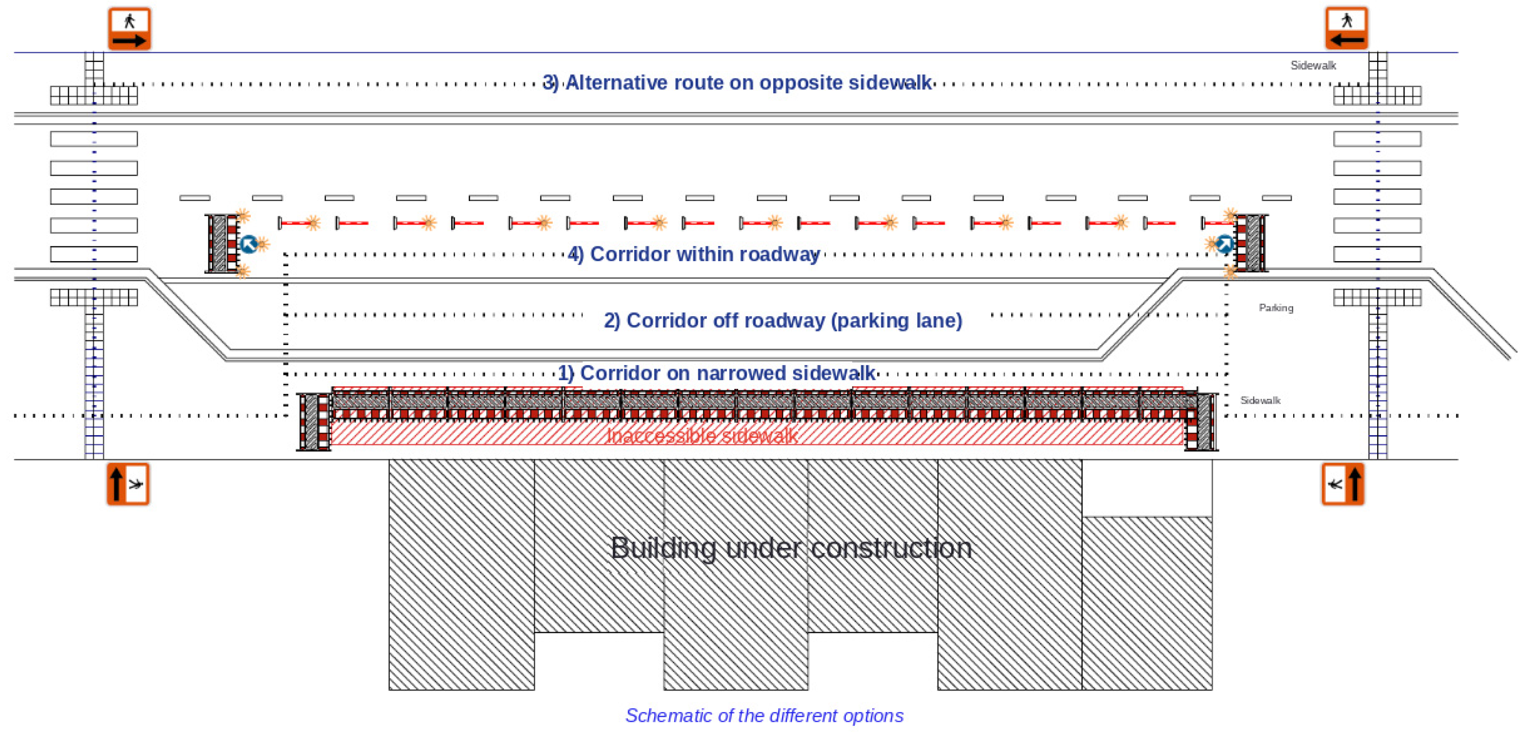
Some web-based platforms also provide visual guidance to support the interpretation of pedestrian accommodation options during sidewalk disruptions. These resources complement written manuals by presenting practical examples of how temporary pedestrian routes can be arranged around a work area. For instance, the SécurOthèque [43] platform includes a detailed figure illustrating several possible accommodation options during a sidewalk closure. Figure 1 reproduces this example, with the labels translated into English. It highlights the main types of temporary pedestrian routes that may be considered depending on the available space around the disrupted sidewalk.
This figure also provides visual support for the accommodation hierarchy summarized in Table 3. It illustrates more than one alternative, ranging from maintaining the existing sidewalk to establishing a protected corridor on the same side of the street, so that the range of options is shown together rather than treated as a single default arrangement.
Beyond these accommodation options, many temporary traffic-control guidance documents rely on schematic layouts to show how a selected detour can be installed in a specific street configuration. These layouts are used in documents such as Tome V [39], the Plateau-Mont-Royal guidance document [38], the City of Edmonton manual [37], and the MUTCD [35]. They commonly illustrate the placement of work areas, pedestrian routes, signs, cones or delineators, buffer spaces, and other temporary traffic-control devices.
Such schematics help illustrate the practical value of these documents for showing how temporary pedestrian accommodation can be arranged on site.
Despite these practical recommendations, the review also highlighted some limitations. Most documents explain how to set up temporary pedestrian routes, signs, barriers, ramps, or channelizing devices, but they provide less support for more constrained situations, such as narrow rights-of-way, uneven surfaces, steep slopes, older infrastructure, or areas with high pedestrian demand. In these contexts, applying accessibility principles can become more difficult in practice. This limitation is important because accessibility guidance emphasizes stable, obstacle-free, and safe pedestrian movement, while many work-zone manuals focus more on the installation and placement of temporary control devices.
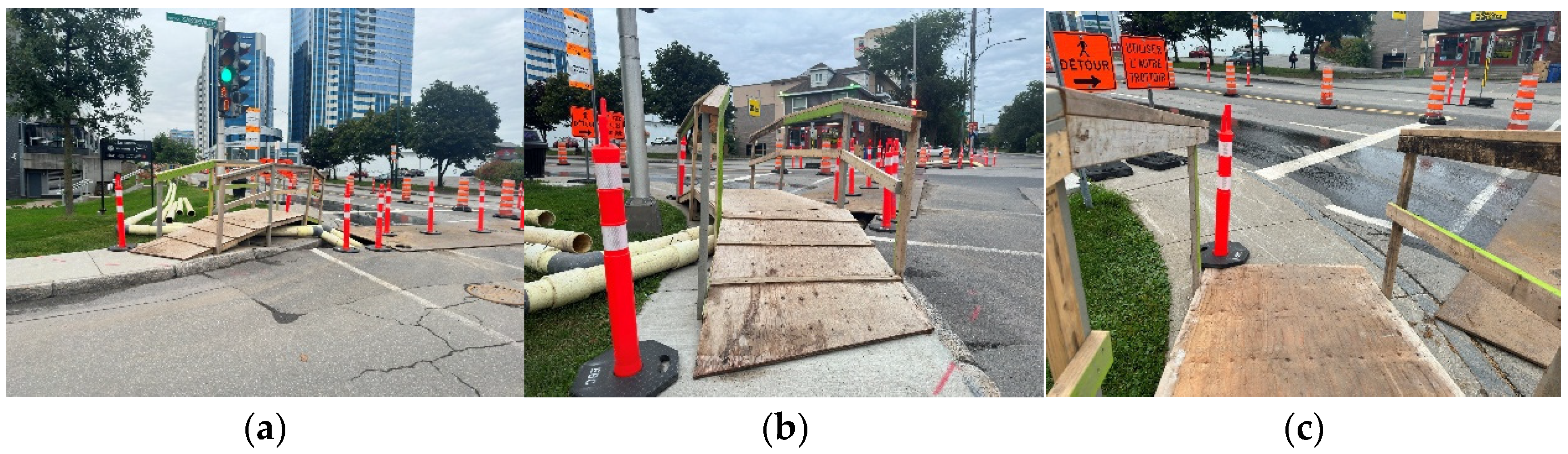
Field observations in Québec also showed temporary pedestrian arrangements that may create accessibility challenges. Figure 2 presents an example where the temporary route includes features that may reduce usability for some pedestrians, particularly persons with mobility limitations. This example illustrates the gap that can exist between accessibility guidance and the conditions observed in real work-zone environments.
The photograph, taken by one of the authors, provides an illustrative example of a temporary pedestrian detour. Although no on-site measurements were conducted, the installation appears to present accessibility concerns, particularly because equipment placed beside the ramp reduces the available passage width and may restrict wheelchair users’ ability to approach and maneuver safely. The example also highlights the limited accessibility specifications provided in Tome V for temporary pedestrian installations and the potential importance of more systematic monitoring after implementation.
The guidance documents we reviewed, including national accessibility standards, the City of Québec’s accessibility guide, and similar guidance from Edmonton, Toronto, and Montréal, do set out accessibility-related criteria for pedestrian infrastructure such as maximum sidewalk slope, surface quality, and curb ramps. None of them, however, deal with temporary sidewalk detours specifically. Even Tome V, the most relevant Québec document, is built around traffic and route management rather than accessibility, and the one internal accessibility guideline shared with us, from P1 in the sample, does not set its own criteria at all; it simply points back to Tome V. So even where accessibility guidance exists on paper, it is not clear how it is meant to apply to detour design.
Overall, the reviewed documents show that accessibility and safety are both considered in temporary traffic-control guidance. However, they are often presented as implementation requirements rather than as part of a structured decision-making process. In other words, the documents explain how to install specific elements, such as signs, barriers, ramps, or temporary walkways, but they provide less support for comparing different detour alternatives or deciding which option is most suitable in a specific spatial context. This finding helped guide the interview analysis by identifying the main criteria to compare with municipal practices.

4.2. Interview Analysis

4.2.1. Theme 1: Detour Design Process

The interviews confirmed that sidewalk detour planning usually begins with a formal request submitted to the municipality, often as part of a broader traffic management or circulation process. As P5 explained, “We receive what we call circulation clause requests. This is really at the stage when our engineering services are preparing the call for tenders”. This shows that the process may begin early in project preparation, when circulation-related conditions are identified and submitted for review.
Once submitted, the proposed detour is evaluated by the relevant municipal department on the basis of several factors, including the location of the blockage, the characteristics of the surrounding street network, traffic conditions on adjacent routes, and the duration of the project. Municipalities may then approve the plan, reject it, or issue a conditional approval requiring specific modifications. Participants also emphasized that the applicant is expected to maintain pedestrian continuity and respect the conditions imposed by the municipality throughout the work period. As one interviewee noted, “We ask [whoever requests the closure] to maintain the pedestrian link, to maintain a traffic lane, and to maintain pedestrian crossings. They are bound by my circulation clause, so they must respect these conditions during the work, otherwise there will be penalties”. This quote highlights that detour approval is not limited to the initial review stage but also involves compliance obligations during implementation.
The interviews also showed that municipalities monitor detour implementation, but not through a formal, standardized procedure. Participants indicated that municipalities have patrol officers available who may notice detour-related issues in the course of their regular duties, but described no dedicated, systematic monitoring protocol specific to detours. Where more targeted follow-up occurs, it takes an informal form: the official responsible for obstruction management explained that they personally follow up by going to the site and judging by eye whether the detour seems comfortable enough for everyone, or, at other times, by observing remotely through urban cameras in a monitoring room. In both cases, this assessment is not based on any defined measurement or accessibility metric, and no mandatory rule requires staff to verify that accessibility conditions are still being met once a detour is in place. When approved conditions are not respected, penalties may be issued and, in some cases, the authorization may be revoked. Although participants indicated that detour plans can technically be modified after implementation when problems are identified, such revisions appear to remain uncommon in practice and are generally avoided unless necessary.

4.2.2. Theme 2: Detour Design Criteria

The interviews showed that sidewalk detour planning involves more than simply keeping pedestrians moving. Safety was usually presented as the main priority, especially to prevent pedestrians from crossing in unsafe locations or walking informally through the roadway to bypass a blocked sidewalk. In larger municipalities, participants described a more detailed assessment of temporary pedestrian corridors, including elements such as slope, width, lighting, visual cues, and corridor delineation. As one interviewee explained, “We describe everything, really what we want to have for a temporary pedestrian corridor in order to judge whether it is safe or not. We compare the slope, the width and the lighting, the visual cues, and the corridor delineation”. This indicates that, in some larger municipalities, detour design is evaluated through both safety and accessibility-related criteria, rather than only through the continuity of pedestrian movement.
The interviews also suggest that larger municipalities, tend to show a more explicit awareness of accessibility requirements, particularly with respect to sidewalk width, curb ramps, and surface conditions. P2, for example, referred to dimensional criteria intended to accommodate wheelchair users: “It is this pedestrian link, the slope, the width of 1.5 metres over 25 metres. After 25 metres, it is 1.8 metres. Why 1.8? To allow someone in a wheelchair to make a U-turn”. This type of statement shows that accessibility standards can be considered in a concrete way when designing temporary pedestrian routes.
However, accessibility was not addressed with the same level of detail across all municipalities. In smaller cities, accessibility considerations appeared less formalized and less systematically integrated into detour planning. The analysis suggests that accessibility is recognized as an important concern, but its application often depends on local constraints, available space, and the tools or procedures used by each municipality. In some cases, the priority seemed to be to identify the simplest and most practical alternative route, rather than to assess accessibility through a detailed set of criteria. This is reflected in the following quote: “The detour route should be as easy as possible, meaning that, obviously, we try to have pedestrians cross if there is a sidewalk on the other side of the street”. Taken together, these findings suggest that accessibility is present in municipal detour planning, but its role in decision-making varies depending on local context, institutional capacity, and the degree to which accessibility practices are formalized.
Where a disruption occurred also shaped which criteria were emphasized. The representative from one large urban municipality described adjusting requirements depending on the surrounding land use: in a residential zone, maintaining residents’ access to their homes was treated as a priority, and where a detour would route pedestrians along a residential street, the safety of residents living there became a consideration in its own right, separate from the safety of the pedestrians being detoured. Network connectivity was raised in similar terms. Participants described preserving the connectivity of the sidewalk network as a priority, explaining, in effect, that a blocked sidewalk is manageable as long as an alternative pathway exists to bypass it, but becomes a more serious problem when no such alternative is available.
Project duration also emerged as a criterion shaping how detours are reviewed. Participants distinguished three categories: short-duration disruptions, lasting about half a day; medium-duration disruptions, lasting three to seven days; and long-duration disruptions, extending beyond that. Medium- and long-duration disruptions require municipal permission before a detour can be implemented, bringing them under the approval process described in Theme 1.

4.2.3. Theme 3: Detour Design Challenges

Despite the existence of universal accessibility guidelines and government or municipal reference documents, participants indicated that these principles are not always translated into consistent operational practice. A key issue was whether accessibility requirements are supported by internal protocols, checklists, or other tools that guide practical decisions during sidewalk closure planning. Although some participants acknowledged the existence of internal procedures referring to accessibility, they also explained that these guidelines are not always mandatory or systematically applied in practice. This can lead to variation in how accessibility is considered, monitored, and enforced across municipalities.
Participants said they do consider some accessibility-related criteria, sidewalk width came up most often, but none described applying these through any mandatory measurement or a structured checklist, and they confirmed directly that no rule requires it for temporary detours. Safety was a different matter: it came up constantly and functioned as the real, de facto priority. P1, for instance, described identifying strategic zones such as school zones where safety criteria are applied more strictly. Accessibility only became a similarly strict requirement in situational cases: P1 described a disruption near a hospital that forced them to keep the route accessible, which suggests accessibility becomes mandatory when it is tied to a sensitive destination, not because of any general standard from the guidance documents reviewed here.
According to the interviews, one challenge is related to the limited flexibility of existing physical infrastructure, especially in older urban environments. P5 explained that some sidewalks were designed according to older standards, with widths that may be acceptable in ordinary conditions but leave little room for accessible temporary arrangements during construction or sidewalk closures. As one interviewee explained, “the sidewalk design standard used to be 1.5 m wide. However, 1.5 m does not provide universal accessibility”. This comment suggests that the difficulty is not only the sidewalk width itself, but also the lack of available space to maintain a comfortable, continuous, and accessible pedestrian path when additional constraints are introduced. Such constraints may become more problematic in older or historic sectors, where the built environment leaves limited flexibility for adaptation and can make it difficult to implement detours that meet universal accessibility expectations. This quotation illustrates that some municipal practitioners are themselves aware of a gap between existing infrastructure and current accessibility expectations, even when working within long-standing design conventions. This awareness did not, however, translate into a described process for systematically identifying or addressing such gaps during detour planning.
A second challenge identified by participants concerns the timing of detour requests. When sidewalk closure requests are submitted with little notice, municipal staff may not have sufficient time to assess all the factors necessary for designing an accessible temporary route. In such situations, accessibility considerations may be overlooked because proper planning requires a broader evaluation of route characteristics, surrounding traffic conditions, and available pedestrian infrastructure. This issue was clearly expressed by P7, who stated, “we have already had cases where we received requests on Friday at 2 p.m. for a closure on Monday”. This quote reflects the pressure created by urgent or late requests and suggests that the lack of planning time can itself become a barrier to accessibility.
A related challenge concerns pedestrians’ ability to actually reach public transportation, rather than a detour’s spatial proximity to a transit stop. One of the public transportation organization participants explained that not all stations in the network are accessible to wheelchair users, and that if a disruption affects access to an accessible station, the nearest alternative may not be accessible either. Despite the significance of this issue, it received comparatively little attention elsewhere in the interviews, suggesting that pedestrians’ access to accessible transit infrastructure is an important but currently under-examined dimension of detour planning.
This duration-based distinction also points to a challenge. Short-duration disruptions are not subject to the same permission requirement as medium- and long-duration ones, and no specific accessibility consideration applies to them, leaving a category of disruptions that may fall outside the scrutiny applied to longer projects.
Taken together, these findings show that accessibility appears only briefly in guidance, is seldom checked against any defined criterion during approval, is assessed on site only informally, and is governed in practice primarily by professional judgement rather than a documented standard.
These findings show that the persistence of inaccessible detours cannot be explained solely by a lack of standards. Rather, it appears to result from the interaction between non-mandatory guidance, inherited infrastructural constraints, and operational pressures that limit the ability of municipalities to fully integrate accessibility into detour planning and implementation.

4.2.4. Theme 4: Use of Geospatial Technologies

A contrast emerged between smaller and larger municipalities. Participants from smaller municipalities reported that they do not use any specific digital tools for this purpose. By contrast, respondents from larger municipalities and organizations described using online mapping platforms, often based on ArcGIS Online.
These tools were described primarily as platforms for sharing project information with obstruction management staff and visualizing spatial information. As one interviewee noted, It is a mapping tool for sharing information.” while another referred to “a mapping tool with different layers.” In some cases, these platforms are linked to internal management systems, as illustrated by the statement, “Of course, we also have a tool that we use internally. This is what we call our TIC software”. Participants explained that such tools are useful for monitoring ongoing and planned projects, identifying conflicts with other activities, and supporting coordination across municipal services.
However, the interviews also made clear that these systems do not function as dedicated detour design tools. They do not automatically generate optimal alternatives based on the geospatial characteristics of a blocked sidewalk segment, nor do they systematically assess accessibility criteria. Their role therefore remains mainly administrative and operational, highlighting the absence of decision-support tools specifically designed to assist municipalities in identifying accessible detour alternatives.

5. Discussion

5.1. Accessibility Awareness and Practical Application Gaps

This study aimed to identify the key criteria considered by municipalities in the design of sidewalk detours and to examine how accessibility is taken into account in this process. The findings show that awareness of universal accessibility principles exists across municipalities, but their application remains uneven in the planning, approval, and monitoring of sidewalk detours. This reflects the difficulty of applying accessibility principles consistently, despite this awareness, within complex municipal, spatial, and operational contexts.
Several guidelines and standards are available to support pedestrian accommodation and accessibility, such as the Guide pratique d’accessibilité universelle used in Québec municipalities, Tome V, and federal accessibility resources, in addition to internal procedures and municipal practices that include accessibility considerations. However, these guidelines and standards mainly provide principles, norms, or implementation guidance. They provide a general preference order for accommodation options but do not offer more detailed tools to systematically compare different detour options or evaluate which alternative is most suitable for a specific sidewalk closure. In practice, municipalities often rely on professionals’ judgment, experience, and project-specific discussions to assess detour proposals. This helps explain why criteria such as pedestrian safety, continuity of movement, and factors related to accessibility (e.g., sidewalk width, slope, surface condition, curb ramps, lighting, visual guidance, and crossing conditions) are considered more systematically in some municipalities than in others.
From a procedural perspective, municipal actors described a process involving request submission, technical assessment, conditional approval, implementation, and field monitoring. However, the ability to apply accessibility criteria consistently is often constrained by the characteristics of the environment, especially in older areas, as well as by operational pressures such as urgent requests and late notifications. These conditions can limit the time and flexibility available to examine all relevant criteria for detour design. In this sense, inaccessible detours do not appear to result only from missing standards, but from the interaction between local contextual constraints, time pressure, and the absence of structured support for comparing alternatives.
Accessibility is present in municipal reasoning, but its role in decision-making varies depending on local context, institutional capacity, available data, operational constraints, and the tools used to support the review process. Pedestrian safety emerged as the most prominent concern, followed by route continuity, width, slope, surface condition, curb ramps, crossing conditions, lighting, and surrounding land-use characteristics. These criteria appear central to accessible detour planning, but they are not always assessed in the same way across municipalities.
Addressing this gap will likely require several complementary efforts. Municipalities could benefit from clearer assessment criteria that explicitly integrate accessibility into detour review. Training may also help municipal staff apply accessibility principles more consistently and with greater confidence. In addition, there is a need for decision-support tools that combine geospatial information with accessibility and safety criteria. Such tools could help decision-makers compare possible detour alternatives, identify spatial constraints, and select options that are both operationally feasible and more accessible for pedestrians with mobility limitations. Future work should therefore focus on strengthening practical support systems that help municipalities move from general accessibility guidance toward more systematic and context-sensitive detour planning.

5.2. Accommodation Hierarchy and Practice

The findings also underline the importance of spatial context in municipal decision-making for temporary pedestrian detour design. Each sidewalk closure occurs within a specific local environment, and this environment influences which criteria become most important in practice. The presence of nearby schools, hospitals, commercial areas, or public transportation stops can increase the need for safe and continuous pedestrian access. More broadly, elements such as street configuration, the presence of sidewalks on the opposite side of the street, nearby controlled crossings, bicycle lanes, parking lanes, access to homes or businesses, and the continuity of the pedestrian network all affect how detour options are assessed. This shows that accessibility cannot be evaluated separately from the surrounding spatial context.
The hierarchy summarized in Table 3 was constructed by identifying the accommodation options described across the guidance documents reviewed (such as maintaining the existing sidewalk, establishing a protected corridor, or redirecting pedestrians to the opposite side) and ordering them from least to most disruptive to pedestrian circulation, consistent with the sequence of preference reflected in the guidance documents reviewed, including the Edmonton manual [37]. Participants’ descriptions of detour planning generally reflected the same underlying logic of preserving pedestrian access before resorting to more disruptive alternatives, although, as discussed below, the specific ordering was not always followed in practice.
The following discussion uses interview accounts to show how closely practice follows this hierarchy. Comparing municipal accounts with the hierarchy summarized in Table 3 suggests that practice does not consistently follow the sequence of preferred responses. The hierarchy prioritizes keeping the existing sidewalk open, then a protected temporary corridor on the same side of the street and treats redirecting pedestrians to the opposite sidewalk as a lower-priority option to be used only when no suitable same-side alternative is feasible. Interview accounts, however, suggest that opposite-side redirection may sometimes function as a default rather than a last resort. This suggests that, in practice, the ordering in Table 3 is not always followed as a sequence of exhausted alternatives but is instead compressed toward the simplest available option.
Several factors help explain this departure. Space constraints in older infrastructure, discussed above, limit the feasibility of a same-side protected corridor, particularly where a sidewalk was originally designed to a narrower standard. Time pressure from late or last-minute requests further limits the ability to assess same-side options in detail before a decision is required. Network connectivity is weighed directly against the hierarchy as well: participants prioritized ensuring that some passable alternative exists over evaluating whether that alternative followed the same-side-first sequence. Finally, because no rule makes accessibility criteria mandatory for temporary detours, and safety functions as the effective mandatory priority, a route that satisfies basic safety requirements can be adopted even where it departs from the accessibility-oriented ordering in Table 3, unless the disruption is located near a destination such as a hospital that prompts closer attention.
For pedestrians with mobility impairments, this departure is not neutral. Redirecting pedestrians to the opposite sidewalk, rather than maintaining a protected corridor on the same side, adds at least two additional crossings to a trip that did not previously require any, increasing exposure to traffic and dependence on the curb ramps and controlled crossings available at that specific location. Where those crossings are not themselves fully accessible, accommodation intended to preserve continuity of movement can instead introduce a barrier that was not present before the disruption occurred.

5.3. Geospatial Decision-Support Tools

Another important finding concerns the use of geospatial and digital tools. Larger municipalities reported using interactive mapping platforms, often based on tools such as (e.g., ArcGIS Online), to visualize and share spatial information internally related to ongoing and planned projects. Some participants also mentioned internal systems developed by their own IT team. These tools appear useful for coordinating projects, monitoring disruptions, and identifying conflicts between planned activities. However, their role remains mainly administrative and operational. They are not designed to automatically generate accessible detour alternatives, compare possible routes, or assess accessibility criteria such as slope, width, curb ramps, surface conditions, or safe crossings. As a result, even when municipalities use digital mapping platforms, these tools provide only partial support for accessible detour planning.
Translating these findings into a geospatial requirements framework, a future tool would need to build on the mapping platforms municipalities already use, such as ArcGIS Online-based systems, in order to minimize adoption barriers and leverage existing institutional familiarity with these tools but add functions those platforms do not currently perform. First, a network-analysis function could generate detour alternatives directly from the sidewalk network graph, applying Table 3 hierarchy to propose same-side options before defaulting to opposite-side redirection, and drawing on network connectivity data to confirm a passable alternative exists before treating a segment as viable. Second, accessibility attributes, such as width, slope, surface condition, and curb ramp locations, geocoded to the sidewalk network, would allow the tool to flag segments with accessibility deficits automatically rather than relying on informal judgment. Third, proximity analysis could incorporate the location of points of interest and, specifically, accessible public transportation stations, so that a proposed detour affecting access to an accessible station is flagged rather than treated the same as one near any station. Fourth, project duration and the timing of a request could be layered onto this spatial information to support comparison of candidate routes against the time pressure that leads municipalities to depart from accessibility-oriented options. This would extend the current use of mapping platforms, from sharing spatial information and coordinating projects, toward a system capable of generating, evaluating, and comparing accessible detour alternatives.

5.4. Limitations

This study has five main limitations. First, this study did not include the perspective of end-users, namely persons with mobility impairments who navigate temporary detours directly. Second, the study did not have access to the internal guidelines municipalities use for approving or designing detours, beyond the single document shared by P1. Third, in practice, the party proposing a detour design is often the construction company responsible for the work, through its own engineers, and this study did not include their perspective. Fourth, this study was conducted within a single geographic and regulatory context (Québec), and findings may not directly generalize to other jurisdictions. Fifth, this study relied on interview accounts rather than systematic field observation or audits of detour installations; while one field example is presented for illustration, it does not reflect a systematic assessment across sites.

6. Conclusions

In this study, we investigated the factors, constraints, and practical challenges that shape detour design and approval by municipalities in real-world contexts. Through a review of guidance documents and semi-structured interviews, we examined how municipalities plan temporary sidewalk detours and how accessibility is incorporated into this process. The findings show that pedestrian safety and continuity of movement are central concerns in detour planning in most municipalities. Accessibility is recognized as a factor to be considered, but it is not always addressed through a consistent and structured approach in temporary pedestrian detour design.
The results further indicate that the integration of accessibility into detour planning is shaped by several practical and contextual constraints, including limited available space, existing infrastructure conditions, short review times, and the absence of dedicated decision-support tools for comparing detour alternatives and selecting the best scenario. Although guidance documents provide useful principles and implementation recommendations, they offer little operational support for applying accessibility criteria in complex urban contexts, where temporary pedestrian routes must often be maintained despite limited space and competing demands. This study contributes to a better understanding of municipal practices for planning and assessing temporary sidewalk detours, the criteria considered in this process, and the place given to accessibility in relation to other planning priorities. The findings also point to the need for more structured assessment methods and geospatial decision-support tools to support a more systematic consideration of accessibility in detour planning. As future work, we plan to investigate how the process of temporary detour design can be automated through a multi-criteria decision-support approach that treats accessibility criteria as indicators, prioritizes them based on information deduced from our interviews, evaluates each potential sidewalk-segment alternative against these indicators, and proposes the most suitable alternative, using methods such as ELECTRE TRI.

Supplementary Materials

The following supporting information can be downloaded at: https://www.mdpi.com/article/10.3390/land15091538/s1, Table S1: Guidance, grey-literature, and academic documents identified in the review described in Section 2 (Guidance and Literature Review) and Section 3.1.2 (Review of Guidelines and Grey Literature), listing issuing body, jurisdiction, year, relevance, and whether each document is cited in the main text.

Author Contributions

Conceptualization, R.R. and M.A.M.; methodology, R.R., A.M. and M.A.M.; formal analysis, R.R.; investigation, A.M. and R.R.; data curation, R.R.; writing, original draft preparation, R.R.; writing, review and editing, R.R., A.M. and M.A.M.; supervision, M.A.M.; project administration, M.A.M.; funding acquisition, M.A.M. All authors have read and agreed to the published version of the manuscript.

Funding

This research was undertaken, in part, thanks to funding from the Canada Research Chairs Program, Natural Sciences and Engineering Research Council of Canada (NSERC). The work was also partially supported by the Mitacs Accelerate Program and in partnership with Quartier l’innovation de Montréal.

Institutional Review Board Statement

The study was conducted in accordance with ethical requirements for research involving human participants and was approved by the Research Ethics Board in Rehabilitation and Social Integration of the Centre intégré universitaire de santé et de services sociaux de la Capitale-Nationale, Project #2024-3014, RIS.

Informed Consent Statement

Informed consent was obtained from all participants involved in the study.

Data Availability Statement

The data supporting the findings of this study are not publicly available due to ethical and confidentiality restrictions related to the interview data. Anonymized excerpts relevant to the analysis may be available from the corresponding author upon reasonable request, subject to ethics approval and confidentiality requirements.

Acknowledgments

The authors would like to thank the municipal and transportation professionals who participated in the interviews and shared their experience regarding sidewalk detour planning, accessibility, and temporary traffic management.

Conflicts of Interest

The authors declare no conflicts of interest.

References

  1. Chadda, H.S.; McGee, H.W.; Ligon, C.M. Pedestrian Accommodation in Highway Work Zones. Transp. Q. 1982, 36, 485–499. [Google Scholar]
  2. Morelli, C.J.; Brogan, J.D.; Hall, J.W. Accommodating Pedestrians in Work Zones. In TRB 2006 Annual Meeting CD-ROM; TRB: Washington, DC, USA, 2005. [Google Scholar]
  3. Blanchard, E.; Duvivier, D.; Kolski, C.; Lepreux, S. Towards a Framework for Detecting Temporary Obstacles and Their Impact on Mobility for Diversely Disabled Users. In HCI in Mobility, Transport, and Automotive Systems; Lecture Notes in Computer Science; Springer: Cham, Switzerland, 2022; Volume 13335, pp. 475–488. [Google Scholar] [CrossRef] [Scilit]
  4. Bascom, G.W.; Christensen, K.M. The impacts of limited transportation access on persons with disabilities’ social participation. J. Transp. Health 2017, 7, 227–234. [Google Scholar] [CrossRef] [Scilit]
  5. Kapsalis, E.; Jaeger, N.; Hale, J. Disabled-by-design: Effects of inaccessible urban public spaces on users of mobility assistive devices—A systematic review. Disabil. Rehabil. Assist Technol. 2022, 19, 604–622. [Google Scholar] [CrossRef] [Scilit] [PubMed]
  6. Ding, D.; Parmanto, B.; Karimi, H.A.; Roongpiboonsopit, D.; Pramana, G.; Conahan, T.; Kasemsuppakorn, P. Design considerations for a personalized wheelchair navigation system. In Proceedings of the 29th Annual International Conference of the IEEE Engineering in Medicine and Biology Society, Lyon, France, 23–26 August 2007; pp. 4790–4793. [Google Scholar] [CrossRef] [Scilit] [PubMed]
  7. Kasemsuppakorn, P.; Karimi, H.A. Personalised routing for wheelchair navigation. J. Locat. Based Serv. 2009, 3, 24–54. [Google Scholar] [CrossRef] [Scilit]
  8. Jahromi, M.N.; Samany, N.N.; Argany, M.; Mostafavi, M.A. Enhancing sidewalk accessibility assessment for wheelchair users: An adaptive weighting fuzzy-based approach. Heliyon 2025, 11, e41101. [Google Scholar] [CrossRef] [Scilit] [PubMed]
  9. Meyers, A.R.; Anderson, J.J.; Miller, D.R.; Shipp, K.; Hoenig, H. Barriers, facilitators, and access for wheelchair users: Substantive and methodologic lessons from a pilot study of environmental effects. Soc. Sci. Med. 2002, 55, 1435–1446. [Google Scholar] [CrossRef] [Scilit] [PubMed]
  10. Eisenberg, Y.; Hofstra, A.; Berquist, S.; Gould, R.; Jones, R. Barrier-removal plans and pedestrian infrastructure equity for people with disabilities. Transp. Res. D Transp. Env. 2022, 109, 103356. [Google Scholar] [CrossRef] [Scilit]
  11. Watkin-McClurg, O.; McDiarmid, C. Mobility Disabilities, 2022; Statistics Canada: Ottawa, ON, Canada, 2024; Available online: https://www150.statcan.gc.ca/n1/pub/11-627-m/11-627-m2024056-eng.htm (accessed on 20 April 2025).
  12. City of Raleigh, Public Works Department. Making Great Strides: A Guide to Accommodating Pedestrians in Active Work Zones; City of Raleigh: Raleigh, NC, USA, 2016. [Google Scholar]
  13. Center for Transportation Research and Education. Pedestrian Accommodations in Work Zones: Systematic Literature Review and Research Needs; InTrans Project 19-535; Institute for Transportation, Iowa State University: Ames, IA, USA, 2021. [Google Scholar]
  14. Center for Universal Design. The Principles of Universal Design, Version 2.0; North Carolina State University: Raleigh, NC, USA, 1997. [Google Scholar]
  15. Iwarsson, S.; Ståhl, A. Accessibility, usability and universal design—Positioning and definition of concepts describing person-environment relationships. Disabil. Rehabil. 2003, 25, 57–66. [Google Scholar] [CrossRef] [Scilit] [PubMed]
  16. Department for Transport. Inclusive Mobility: A Guide to Best Practice on Access to Pedestrian and Transport Infrastructure; Department for Transport: London, UK, 2021. [Google Scholar]
  17. Kockelman, K.; Heard, L.; Kweon, Y.-J.; Rioux, T.W. Sidewalk cross-slope design: Analysis of accessibility for persons with disabilities. Transp. Res. Rec. 2002, 1818, 108–118. [Google Scholar] [CrossRef] [Scilit]
  18. Soares Müller, A.P.; Goulart Dorneles, V.; Ruiz-Padillo, A.; Vieira Romano, F. Sidewalk Assessment from the Perspective of Accessibility: A Systematic Literature Review. J. Urban Plan Dev. 2023, 149, 04023032. [Google Scholar] [CrossRef] [Scilit]
  19. Völkel, T.; Kühn, R.; Weber, G. Mobility impaired pedestrians are not cars: Requirements for the annotation of geographical data. In Computers Helping People with Special Needs; Lecture Notes in Computer Science; Springer: Berlin/Heidelberg, Germany, 2008; Volume 5105, pp. 1085–1092. [Google Scholar] [CrossRef] [Scilit]
  20. Kasemsuppakorn, P.; Karimi, H.A.; Ding, D.; Ojeda, M.A. Understanding route choices for wheelchair navigation. Disabil. Rehabil. Assist Technol. 2015, 10, 198–210. [Google Scholar] [CrossRef] [Scilit] [PubMed]
  21. Kozievitch, N.P.; Almeida, L.D.A.; Dutra da Silva, R.; Minetto, R. An Alternative and Smarter Route Planner for Wheelchair Users Exploring Open Data. In Proceedings of the 5th International Conference on Smart Cities and Green ICT Systems (SMARTGREENS 2016), Rome, Italy, 23–25 April 2016. [Google Scholar]
  22. Gharebaghi, A.; Mostafavi, M.-A.; Edwards, G.; Fougeyrollas, P.; Morales-Coayla, P.; Routhier, F.; Leblond, J.; Noreau, L. A confidence-based approach for the assessment of accessibility of pedestrian network for manual wheelchair users. In Advances in Cartography and GIScience; Lecture Notes in Geoinformation and Cartography; Springer: Cham, Switzerland, 2017; pp. 463–477. [Google Scholar] [CrossRef] [Scilit]
  23. Wang, W.; Zhang, J.; Li, H.; Xie, Q. Experimental study on unidirectional pedestrian flows in a corridor with a fixed obstacle and a temporary obstacle. Phys. A Stat. Mech. Its Appl. 2020, 560, 125188. [Google Scholar] [CrossRef] [Scilit]
  24. Geoerg, P.; Schumann, J.; Boltes, M.; Kinateder, M. How people with disabilities influence crowd dynamics of pedestrian movement through bottlenecks. Sci. Rep. 2022, 12, 14273. [Google Scholar] [CrossRef] [Scilit] [PubMed]
  25. Levine, K. “The bus is accessible, but how do you get to the bus”: First and last mile experiences of disabled transit riders. J. Public Trans. 2024, 26, 100086. [Google Scholar] [CrossRef] [Scilit]
  26. Bolten, N.; Amini, A.; Hao, Y.; Ravichandran, V.; Stephens, A.; Caspi, A. Urban sidewalks: Visualization and routing for individuals with limited mobility. In Proceedings of the 1st International ACM SIGSPATIAL Workshop on Smart Cities and Urban Analytics (UrbanGIS’15), Bellevue, WA, USA, 3 November 2015; pp. 122–125. [Google Scholar] [CrossRef] [Scilit]
  27. Mobasheri, A.; Deister, J.; Dieterich, H. Wheelmap: The wheelchair accessibility crowdsourcing platform. Open Geospat. Data Softw. Stand. 2017, 2, 27. [Google Scholar] [CrossRef] [Scilit]
  28. Prandi, C.; Barricelli, B.R.; Mirri, S.; Fogli, D. Accessible wayfinding and navigation: A systematic mapping study. Univers. Access Inf. Soc. 2023, 22, 185–212. [Google Scholar] [CrossRef] [Scilit]
  29. Texas Department of Transportation. Pavement Manual; Maintenance Division, Texas Department of Transportation: Austin, TX, USA, 2021. [Google Scholar]
  30. Sullivan, A.; Sisiopiku, V.; Gilliam, P.; Khan, M.D.; Anni, A. Evaluating Detours for a Major Construction Project in the Era of Real-Time Route Guidance; Southeastern Transportation Research, Innovation, Development and Education Center (STRIDE), University of Florida: Gainesville, FL, USA, 2023. [Google Scholar]
  31. Morshedi, M.; Padhye, S.; Mwamba, I.; Kang, K.; Labi, S.; Hastak, M. Suitability Assessment of Detour Routes for Road Construction Projects: Framework and Case Studies. J. Manag. Eng. 2023, 39, 04022077. [Google Scholar] [CrossRef] [Scilit]
  32. Gamache, S. Mesure Environnementale de L’accessibilité (MEA); Centre intégré universitaire de santé et de services sociaux de la Capitale-Nationale: Québec, QC, Canada, 2018. [Google Scholar]
  33. Sandelowski, M. Whatever happened to qualitative description? Res. Nurs. Health 2000, 23, 334–340. [Google Scholar] [CrossRef] [Scilit]
  34. Bradshaw, C.; Atkinson, S.; Doody, O. Employing a Qualitative Description Approach in Health Care Research. Glob. Qual. Nurs. Res. 2017, 4, 2333393617742282. [Google Scholar] [CrossRef] [Scilit] [PubMed]
  35. Federal Highway Administration. Manual on Uniform Traffic Control Devices for Streets and Highways, 11th ed.; U.S. Department of Transportation, Federal Highway Administration: Washington, DC, USA, 2023. [Google Scholar]
  36. City of Saskatoon. Temporary Traffic Control Manual; City of Saskatoon: Saskatoon, SK, Canada, 2024. [Google Scholar]
  37. City of Edmonton. Manual of Temporary Traffic Control; City of Edmonton: Edmonton, AB, Canada, 2021. [Google Scholar]
  38. Ville de Montréal; Arrondissement du Plateau-Mont-Royal. Signalisation Routière—Travaux en Milieu Métropolitain Avec Maintien D’aménagements Cyclables et Piétons; Ville de Montréal: Montréal, QC, Canada, 2025. [Google Scholar]
  39. Ministère des Transports et de la Mobilité durable. Tome V—Signalisation Routière; Les Publications du Québec: Québec, QC, Canada, 2024. [Google Scholar]
  40. Ville de Québec. Guide Pratique D’accessibilité Universelle: Manuel D’utilisation; Ville de Québec: Québec, QC, Canada, 2010. [Google Scholar]
  41. Etikan, I. Comparison of Convenience Sampling and Purposive Sampling. Am. J. Theor. Appl. Stat. 2016, 5, 1. [Google Scholar] [CrossRef] [Scilit]
  42. Vaismoradi, M.; Turunen, H.; Bondas, T. Content analysis and thematic analysis: Implications for conducting a qualitative descriptive study. Nurs. Health Sci. 2013, 15, 398–405. [Google Scholar] [CrossRef] [Scilit] [PubMed]
  43. Service public de Wallonie. Gestion des piétons lors des chantiers. Sécurothèque. Available online: https://securotheque.wallonie.be/Gestion%20des%20pi%C3%A9tons%20lors%20des%20chantiers (accessed on 21 May 2026).
  44. Chadda, H.S.; McGee, H.W. Pedestrian Safety Through Work Zones: Guidelines. J. Transp. Eng. 1983, 109, 785–799. [Google Scholar] [CrossRef] [Scilit]
  45. Shaw, J.W.; Bremer, W.; Chitturi, M.V.; Bill, A.; Noyce, D.A. Guidelines For Work Zone Designers: Pedestrian and Bicycle Accommodation; University of Wisconsin–Madison: Madison, WI, USA, 2023. [Google Scholar]
  46. Duvall, J.; Cooper, R.; Sinagra, E.; Stuckey, D.; Brown, J.; Pearlman, J. Development of surface roughness standards for pathways used by wheelchairs. Transp. Res. Rec. 2013, 2387, 149–156. [Google Scholar] [CrossRef] [Scilit]
  47. Ville de Québec; Institut de réadaptation en déficience physique de Québec (IRDPQ). Guide Pratique D’accessibilité Universelle: Fiche 16—Mobilité lors de Travaux Extérieurs ou Intérieurs; Service de l’aménagement du territoire, Ville de Québec: Québec, QC, Canada, 2010. [Google Scholar]
  48. Ministère des Transports et de la Mobilité durable. Plan D’action 2023–2026 en Matière de Sécurité sur les Sites de Travaux Routiers; Ministère des Transports et de la Mobilité durable: Québec, QC, Canada, 2023. [Google Scholar]
Figure 1. Pedestrian accommodation options during a sidewalk closure caused by a building under construction. The numbered options show alternative temporary pedestrian routes: (1) a corridor on the narrowed sidewalk; (2) a corridor off the roadway, in the parking lane; (3) an alternative route on the opposite sidewalk; and (4) a corridor within the roadway. Black dotted lines indicate pedestrian routes, and the red hatched band marks the inaccessible sidewalk. Red-and-white elements are temporary barriers, and the orange starbursts represent flashing warning lights mounted on them. Orange signs show pedestrian detour signage and the direction of travel, and blue arrows indicate crossing points. Reproduced from SécurOthèque [43] with permission; labels translated from the original French.
Land 15 01538 g001
Figure 2. Field example of a temporary pedestrian detour observed in Québec, showing features associated with reduced accessibility: (a) the detour as implemented, with a plywood walkway and wooden handrail routed around the work area and separated from traffic by orange delineator posts; (b) the surface quality of the installed ramp, showing overlapping plywood panels, open joints, and unbevelled edges; (c) a delineator post standing at the end of the ramp, restricting the space available for manoeuvring at the transition onto the sidewalk.
Land 15 01538 g002
Table 1. Characteristics of interview participants.
ParticipantOrganization TypeMunicipality/Organization SizeProfessional RoleInvolvement in Process
P1MunicipalityLarge urbanObstruction management; collaborates with the engineering department during project planningPlanning, approval, traffic management
P2MunicipalityLarge urbanObstruction management; collaborates with the engineering department during project planningPlanning, approval, traffic management
P3MunicipalityMid-sizedObstruction management; collaborates with the engineering department during project planningPlanning, approval, traffic management
P4MunicipalityMid-sizedObstruction management; collaborates with the engineering department during project planningPlanning, approval, traffic management
P5MunicipalitySmaller/regionalObstruction management; collaborates with the engineering department during project planningPlanning, approval, traffic management
P6Transportation organizationN/ACoordinates special-event service additions and obstruction management for an assigned territory; liaises with field inspectors and patrollersImplementation, field monitoring, coordination
P7Transportation organizationN/AClient experience advisor; equipment recommendations and testing; involved in universal accessibility planning at a network-wide levelAccessibility planning and policy input
Table 2. Relationship between Codes, Themes, and Research Objectives.
Initial Code (Deductive)Added Code (Inductive)ThemesStudy Objective
Sidewalk Closure Request
Sidewalk Closure Analysis
Detour Implementation & Monitoring
Modification of inaccessible detoursDetour Design ProcessUnderstanding the detour design process and the challenges of ensuring accessibility
Accessibility
Safety
Spatial Context
Detour Feasibility Criteria
Project Duration
Proximity to Points of Interest
Accessibility of Nearby Public Transportation Stations
Sidewalk Network Connectivity
Detour Design CriteriaUnderstanding the priority of accessibility among decision criteria and environmental factors in detour planning
Absence of Mandatory Accessibility Regulations
Time Constraints (Last-Minute Scenarios)
Lack of Solutions for Complex Spatial Constraints
Detour Design ChallengesTo identify the factors that lead to inaccessible detour designs
Geospatial Software for designing a detour
Geospatial Software for Managing Detours
Use of Geospatial Detour Design TechnologyTo identify whether municipalities use geospatial tools to design and manage pedestrian detours
Table 3. Synthesis of preferred pedestrian accommodation responses during sidewalk disruptions.
Design SituationPreferred ResponseAlternative ResponseLower-Priority Response
Sidewalk can remain usableKeep pedestrians on the existing sidewalkReduce the clear width only if necessary and still accessibleRedirect pedestrians only if the sidewalk cannot safely remain open
Sidewalk is fully blocked and parallel space is availableProvide a protected temporary pedestrian corridor on the same side of the street, using available parallel space such as a parking lane or curbside laneUse a shared temporary pedestrian/cyclist corridor if space is limitedRedirect pedestrians to the opposite sidewalk only if no suitable same-side option is feasible
Sidewalk and cycling facility are both affectedMaintain separate temporary spaces for pedestrians and cyclists where possibleProvide a shared temporary facility if conflicts can be managedDetour pedestrians or cyclists to another route
No same-side temporary corridor is feasibleUse an open sidewalk on the opposite side of the street, if safe and accessible crossings are availableProvide another clearly signed alternative routeAvoid long, unclear, or inaccessible detours
Long-duration closureProvide a stable and protected temporary pedestrian facilityAdd stronger barriers, ramps, lighting, and maintenance measuresAvoid relying only on simple “sidewalk closed” signs
Disclaimer/Publisher’s Note: The statements, opinions and data contained in all publications are solely those of the individual author(s) and contributor(s) and not of MDPI and/or the editor(s). MDPI and/or the editor(s) disclaim responsibility for any injury to people or property resulting from any ideas, methods, instructions or products referred to in the content.