1. Introduction
Human-driven land-use change has transformed natural ecosystems into agricultural land [
1], profoundly altering biodiversity patterns. Species movement, functional connectivity, and dispersal depend heavily on landscape composition and configuration [
2,
3]. Fragmentation—characterized by smaller, isolated habitat patches—is a key driver of population declines and species extinctions [
4], contributing to the growing number of endangered species across Europe [
5]. Conversely, agricultural landscapes structured as diverse mosaics can support biodiversity and essential ecosystem services, such as pollination and biological pest control [
6]. Nonetheless, the benefits of crop heterogeneity depend on field size, spatial arrangement, and accessibility within the landscape [
1], and the effects of landscape complexity on pests and natural enemies arise from interacting ecological mechanisms [
7].
Together, these processes contribute to agricultural landscape simplification, a structural transformation that has become one of the defining characteristics of modern agricultural systems. In this study, agricultural landscape simplification is defined as the increasing dominance of agricultural land cover and focal crop types relative to natural and semi-natural habitats, resulting in reduced landscape heterogeneity and habitat complexity.
Monoculture—defined as the specialization of a single crop over large areas—represents one of the most intense anthropogenic disturbances in terrestrial ecosystems. Modern agriculture remains heavily reliant on annual crop monoculture such as wheat, maize, and rice, contributing to soil degradation, pollution, greenhouse gas emissions, and biodiversity loss [
8]. While biodiversity research traditionally emphasized species richness, the erosion of crop genetic diversity also poses major risks to agricultural sustainability [
9]. Crop diversification operates at multiple levels—from plot-scale species mixtures to landscape-scale heterogeneity and the integration of wild vegetation [
10,
11]—but its broader adoption is constrained by economic priorities dominating modern plant breeding programs [
12].
Previous studies have extensively examined the ecological consequences of agricultural intensification and landscape simplification, but most have focused on local or regional scales [
13], specific time periods [
1], or individual crop systems [
1,
14]. Comparatively fewer studies have evaluated long-term landscape trajectories using harmonized datasets across multiple hierarchical scales [
15]. Moreover, the extent to which different agricultural systems respond similarly or differently to landscape change remains insufficiently understood [
6]. These limitations constrain our ability to identify general patterns of agricultural landscape evolution and to distinguish broad-scale processes from region-specific dynamics.
Landscape change analysis has become a fundamental tool for understanding how human activities reshape ecological processes across space and time. Changes in land-use composition and configuration influence habitat availability, connectivity, ecosystem functioning and biodiversity conservation. Consequently, landscape metrics are widely used to quantify spatial patterns and assess the degree of landscape simplification, fragmentation and heterogeneity. Long-term analyses of landscape dynamics are particularly valuable because they allow researchers to identify persistent trends, evaluate the effects of agricultural policies and support evidence-based land-use planning.
The study period (1990–2018) encompasses major transformations in European agricultural policy under successive reforms of the Common Agricultural Policy (CAP). Since the early 1990s, the CAP has progressively evolved from a production-oriented framework towards a broader approach that increasingly incorporates environmental objectives, biodiversity conservation and rural development measures. In particular, the MacSharry reform (1992) introduced agri-environmental measures and reduced the emphasis on production-linked support, while subsequent reforms strengthened environmental requirements and promoted more sustainable land management practices [
16]. More recently, the introduction of greening measures in 2013 further reinforced the integration of environmental considerations into agricultural policy. These policy changes have influenced land-use decisions, crop specialization and habitat management across Europe, making the period 1990–2018 particularly suitable for evaluating long-term changes in agricultural landscape simplification and natural habitat complexity [
17].
Despite growing recognition of the ecological importance of landscape complexity, there remains limited understanding of how agricultural landscapes have evolved over recent decades across different territorial scales and crop systems. Addressing this gap is essential for informing land-use policies aimed at balancing agricultural production with biodiversity conservation and landscape resilience. Because long-term landscape trajectories rarely follow linear responses, analytical approaches capable of modeling complex temporal dynamics are required. Traditional linear regression assumes constant rates of change through time and may fail to identify threshold responses or nonlinear transitions associated with agricultural intensification and policy reforms. Generalized additive models (GAMs) overcome these limitations by fitting flexible smooth functions, allowing the detection of gradual changes, turning points and nonlinear temporal trajectories without imposing a predefined functional form. Consequently, GAMs provide an appropriate framework for analyzing long-term agricultural landscape dynamics [
18].
Based on this framework, we pursue three main objectives: (i) To quantify long-term trends (1990–2018) in agricultural landscape simplification and natural habitat complexity across three spatial scales—Europe, Spain, and Extremadura—using CORINE Land Cover data. (ii) To assess how these trends differ among different agricultural categories (total agriculture, vineyards, olive groves, and rice fields). Although not intended to represent the full diversity of European agriculture, these systems provide useful case studies for examining long-term landscape trajectories across contrasting agricultural contexts. (iii) To evaluate the extent to which crop type and geographical context shape patterns of landscape change, providing insights relevant to land-use planning and agro-environmental policy.
2. Materials and Methods
2.1. Study Area
2.1.1. Europe
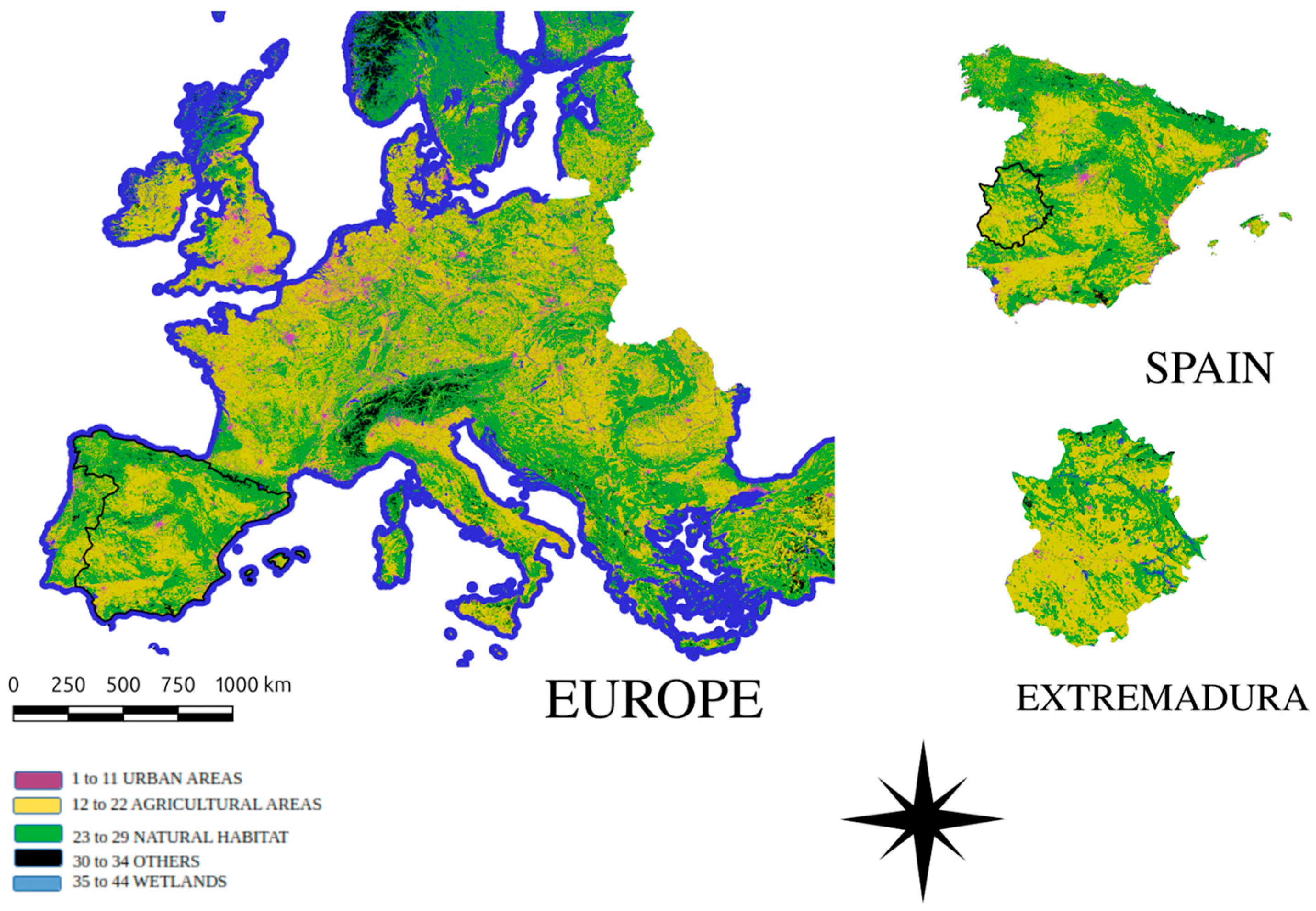
At the European scale, agricultural land is widely distributed across France, Italy, Eastern Europe and the British Isles, whereas natural habitats are concentrated mainly in mountainous and northern regions such as Scandinavia, Iceland, the Alps and the Carpathians (
Figure 1). Vineyards are predominantly located in Spain, France and Italy (
Figure S1), olive groves are concentrated in southern Europe (
Figure S2), and rice cultivation is mainly restricted to Mediterranean wetlands and river valleys in Spain and Italy (
Figure S3).
2.1.2. Spain
At the national scale, Spain is characterized by a heterogeneous landscape in which major urban centers and coastal agglomerations coexist with extensive agricultural areas located mainly in Castilla y León, Castilla–La Mancha, Extremadura, Andalusia and the Ebro Valley (
Figure 1). Forest and semi-natural habitats are concentrated primarily in mountainous regions. Vineyards are widely distributed across Spain, particularly in Castilla–La Mancha, La Rioja and Extremadura (
Figure S1), while olive groves are concentrated in Andalusia, Castilla–La Mancha and Extremadura (
Figure S2). Rice cultivation is mainly restricted to irrigated areas in the Ebro Delta, Andalusia and Extremadura (
Figure S3).
2.1.3. Extremadura
At the regional scale, Extremadura is dominated by a mosaic of natural and agricultural land covers, with urban development concentrated around the main population centers of Badajoz and Cáceres (
Figure 1). Vineyards are especially abundant in the Tierra de Barros region (
Figure S1), olive groves are widely distributed throughout the territory (
Figure S2), and rice cultivation is concentrated in the irrigated plains of the Guadiana River (
Figure S3). To ensure comparability among spatial scales, the same land-cover datasets, landscape metrics and analytical procedures were applied at the European, national and regional scales.
2.2. Data Source
CORINE Land Cover (CLC) dataset (Copernicus Land Monitoring Service, European Environment Agency (EEA), Copenhagen, Denmark) corresponding to the reference years 1990, 2000, 2006, 2012 and 2018 were obtained from the Copernicus Land Monitoring Service (CLMS;
https://land.copernicus.eu/; accessed on 20 November 2024) through the official CORINE Land Cover data portal (
https://land.copernicus.eu/en/products/corine-land-cover; accessed on 20 November 2024). The CLC program is coordinated within the framework of the European Environment Agency (EEA), which provides harmonized land-cover information across Europe using a standardized classification system. The CLC database comprises 44 land-cover classes, with a minimum mapping unit (MMU) of 25 ha and a minimum mapping width of 100 m. Although CORINE is particularly suitable for continental-scale analyses and long-term comparisons, its MMU may underrepresent highly fragmented agricultural landscapes and small agricultural patches, potentially leading to an underestimation of local-scale fragmentation and landscape heterogeneity, particularly in Mediterranean systems characterized by dispersed vineyards and olive groves. The study was carried out at three spatial scales: Europe (defined as EU-27 plus the United Kingdom), Spain (national territory), and the autonomous community of Extremadura. These scales represent a hierarchical framework encompassing continental, national and regional levels, allowing broad-scale trends in agricultural landscape change to be contrasted with context-specific dynamics. Comparisons among scales were performed using identical sampling procedures, buffer dimensions and analytical methods, ensuring methodological consistency through the use of a single harmonized land-cover dataset.
The selected crop systems should not be interpreted as representative of the full diversity of European agriculture. They were chosen because they are consistently identifiable within the CORINE classification and represent economically and ecologically important agricultural systems, particularly in Mediterranean regions.
2.3. Landscape Characterization
Landscape composition around each agricultural system was characterized through random spatial sampling. Sampling points were generated using a random-point generation algorithm implemented in R and specifically designed for this study. For each territory and reference year, 1000 points were randomly distributed across the study area. Points were generated independently for each year, allowing a consistent representation of landscape conditions throughout the study period.
Around every point, a circular buffer of 1000 m radius was created in order to capture the immediate landscape context, which is ecologically relevant for key processes such as species movement, ecological connectivity and the flow of ecosystem services [
19].
Within each buffer, the proportional cover of all CLC land-use categories was extracted, resulting in a set of values ranging between 0 and 1 that represent the fraction of the buffer occupied by each class. This procedure generated a spatial composition matrix that describes, for every sampling point, the surrounding landscape in a consistent and comparable way. From this matrix, two main indicators were derived. The proportion of the focal crop—vineyards, olive groves, rice fields or total agriculture—was used as a proxy for landscape simplification. The proportion of natural habitat, calculated by aggregating forest areas, shrub and herbaceous vegetation, and sparsely vegetated surfaces, was used as a proxy for landscape complexity.
The indicators were selected based on their direct ecological interpretation and compatibility with CORINE Land Cover data. We prioritized compositional metrics because they can be consistently calculated across large spatial extents and multiple time periods using a harmonized land-cover dataset. The proportion of focal crops was used to represent increasing agricultural dominance within the landscape, whereas the proportion of natural habitats was used to represent the availability of non-crop elements contributing to landscape heterogeneity.
The 1 km radius was selected because it aligns with ecologically meaningful scales for many farmland organisms and because it matches widely used landscape ecology thresholds in studies of agricultural biodiversity [
15]. In this study, landscape simplification is interpreted as a structural characteristic associated with increasing dominance of agricultural land cover, rather than a direct measure of management intensity, agricultural practices or land-use transitions.
We acknowledge that landscape simplification and complexity can be characterized using a wide range of compositional and configurational metrics, including diversity, aggregation and patch-based indices. However, because the objective of this study was to evaluate broad-scale temporal trends consistently across multiple spatial scales using a harmonized continental dataset, we selected proportional indicators that are robust, directly interpretable and comparable through time. The proportion of focal crops and natural habitats has been widely used as a structural representation of landscape simplification and habitat availability in agricultural landscape studies.
All geospatial operations, including the generation of sampling points, the construction of buffers and the extraction of land-cover proportions, were conducted using QGIS software (QGIS Development Team, Open Source Geospatial Foundation, Beaverton, OR, USA; version 3.34). This ensured transparent documentation of the spatial workflow and replicability of the landscape metrics used in the analysis.
2.4. Statistical Analysis
To analyze temporal changes in landscape simplification and complexity, we employed generalized additive models (GAMs). This approach is particularly appropriate for long-term ecological datasets because it allows the relationship between the response variables and time to be modeled flexibly through smooth functions rather than assuming linearity. Two response variables were defined: the proportion of the focal crop within each buffer, representing landscape simplification, and the proportion of natural habitat within the buffer, representing landscape complexity. Both variables were treated as binomial proportions and modeled using a logit link function.
The predictor variable was the year of data acquisition, treated as a continuous variable with values corresponding to 1990, 2000, 2006, 2012 and 2018. This treatment allowed the GAMs to estimate smooth, non-parametric temporal trajectories for each crop and region. Models were fitted using the mgcv package (version 1.9-3) [
18] in the R statistical software (R Foundation for Statistical Computing, Vienna, Austria; version 4.4.1), with smoothing parameters estimated via restricted maximum likelihood (REML). Model diagnostics included assessment of residual patterns and tests for heteroscedasticity. No evidence of structured residual behavior or violation of model assumptions was detected, indicating satisfactory fit.
The temporal trends, together with their 95% confidence intervals, were visualized using the ggplot2 package (version 3.5.2) [
20], which provided clear and consistent graphical representations of the smoothed trajectories. This analytical framework, combining harmonized land-cover data, multi-scale landscape sampling, and flexible GAM modeling, offers a robust basis for quantifying long-term changes in agricultural landscapes and examining their implications for biodiversity conservation and land-use sustainability.
The tabulated results evaluate whether the relationships between agricultural cover and the surrounding environment—expressed through the indices of simplification and complexity—reach statistical significance. Values with p-levels greater than 0.05 were considered non-significant, whereas values below this threshold indicate increasing levels of statistical support for the observed relationships. In particular, p-values between 0.05 and 0.01 indicate moderate statistical support, values between 0.01 and 0.001 indicate strong statistical support, and values below 0.001 indicate very strong statistical support. These thresholds facilitate the interpretation of the robustness of the detected associations. For each crop and each territorial level, the analyses quantify the extent to which agricultural cover contributes to homogenization (landscape simplification) or interacts with natural habitats (landscape complexity), thereby providing insight into the ecological consequences of agricultural expansion or decline.
The generalized additive models (GAMs) employed here provide a flexible statistical framework that captures the nonlinear relationships underlying landscape dynamics. Through these models, it is possible to compare patterns of simplification and complexity across Europe, Spain and Extremadura, discerning not only whether significant associations exist but also how strongly agricultural practices reshape their surroundings. Landscape simplification is interpreted as an increase in agricultural cover relative to the broader landscape matrix, reflecting reduced landscape heterogeneity; conversely, complexity measures the proportion and structural importance of natural habitats in the landscape surrounding agricultural areas. Together, these indicators offer a dual perspective that accounts for both agricultural intensification and ecological resilience.
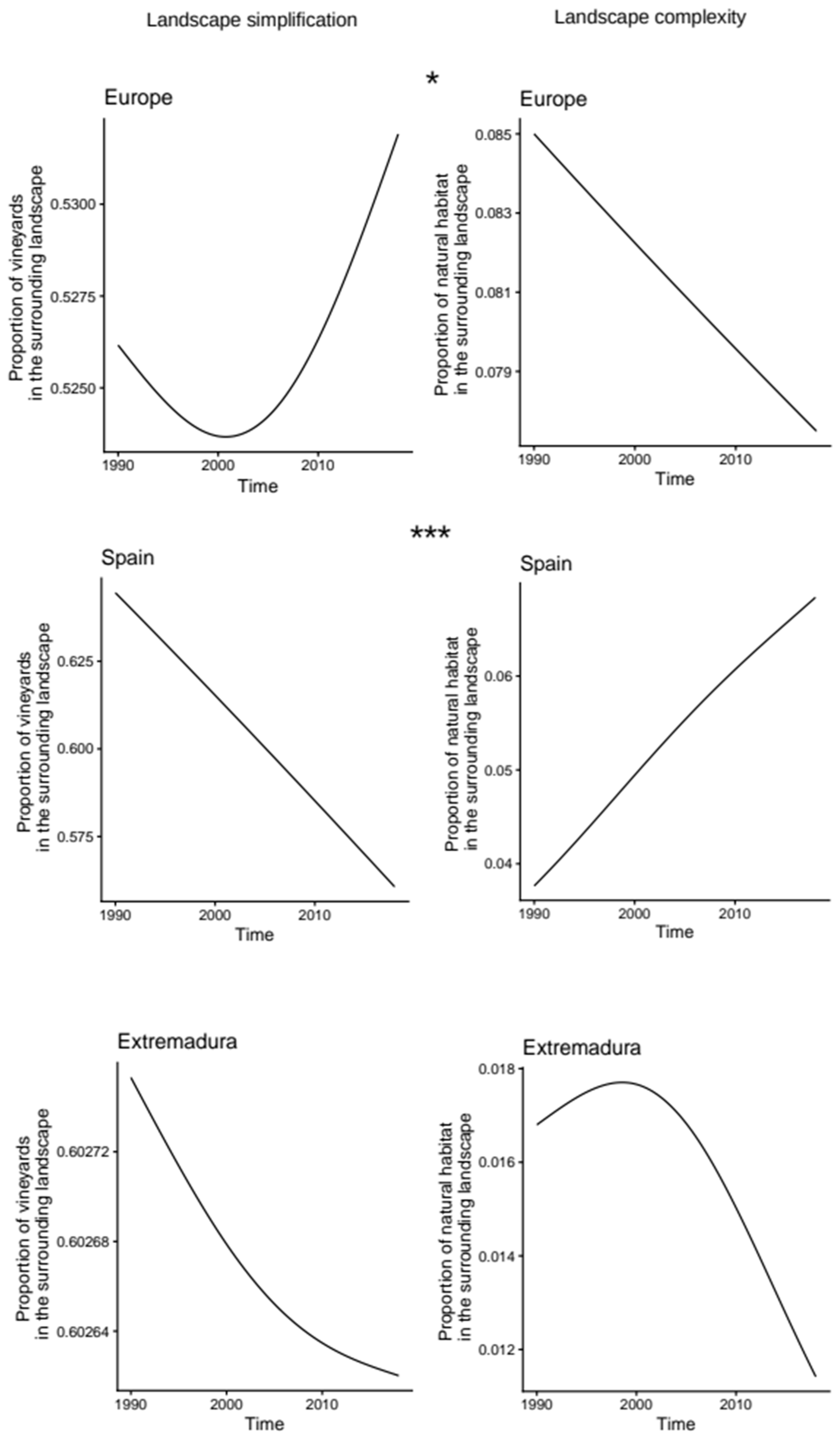
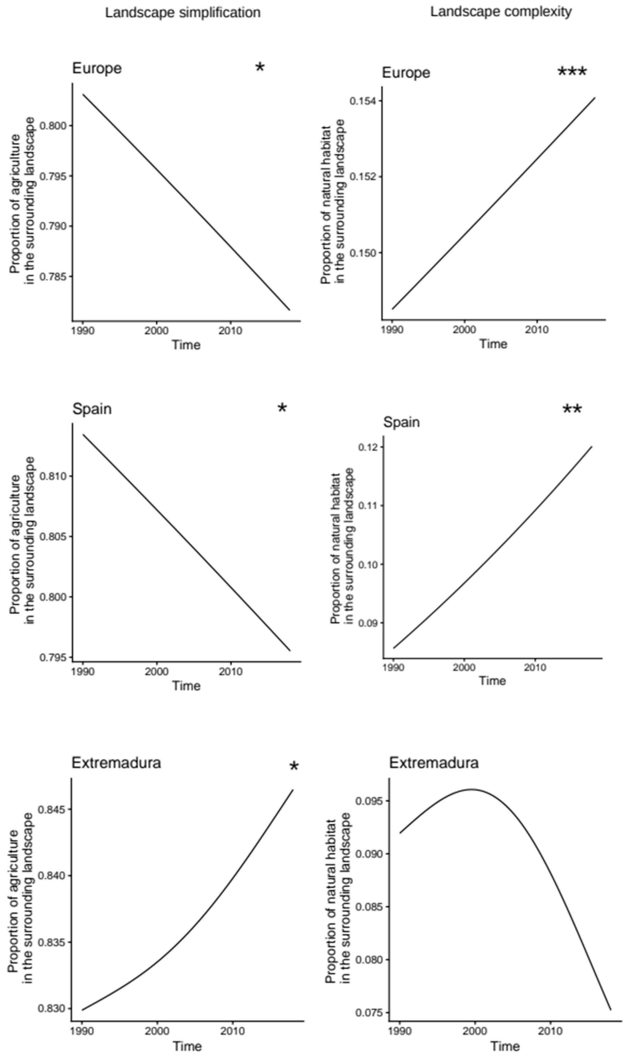
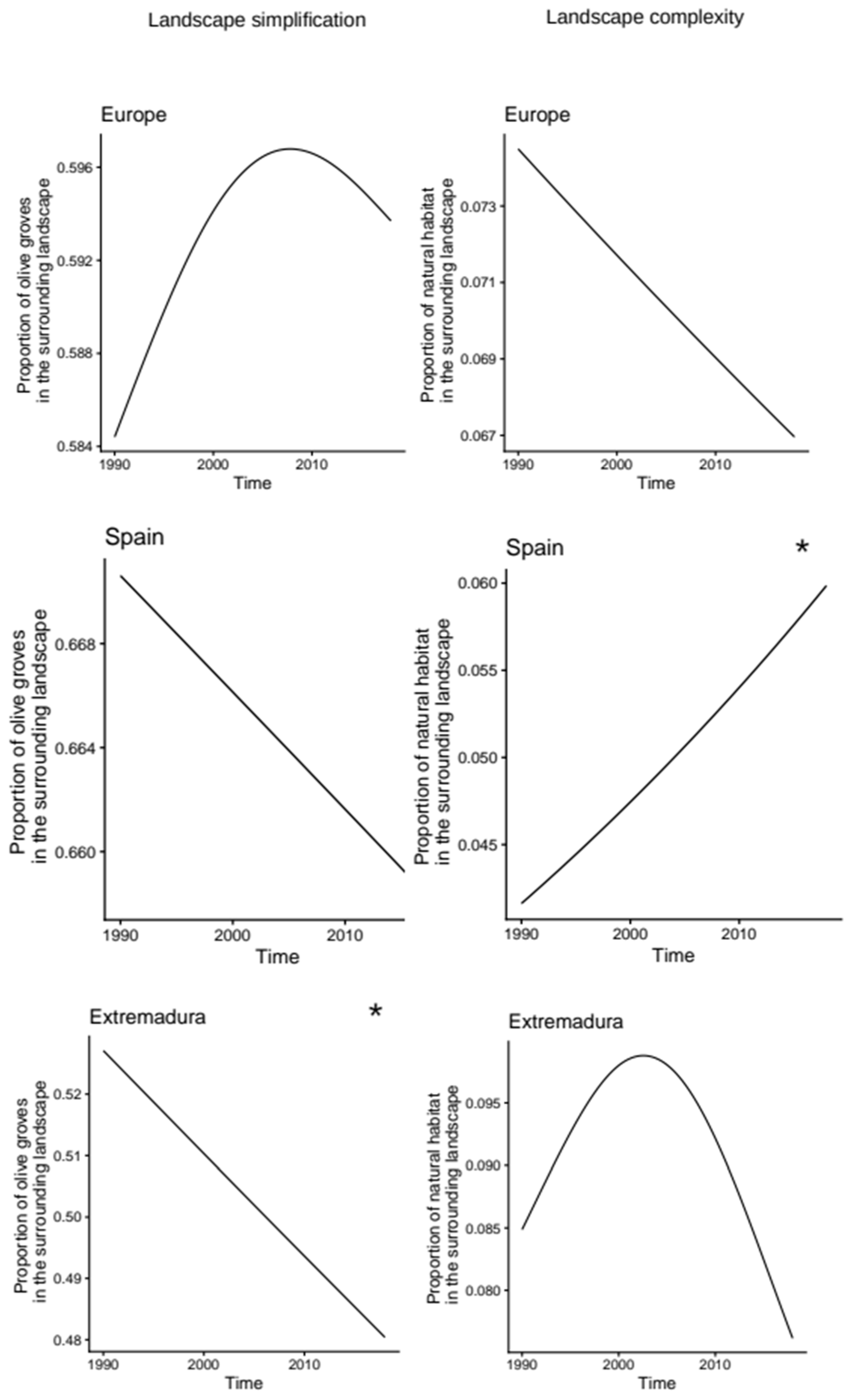
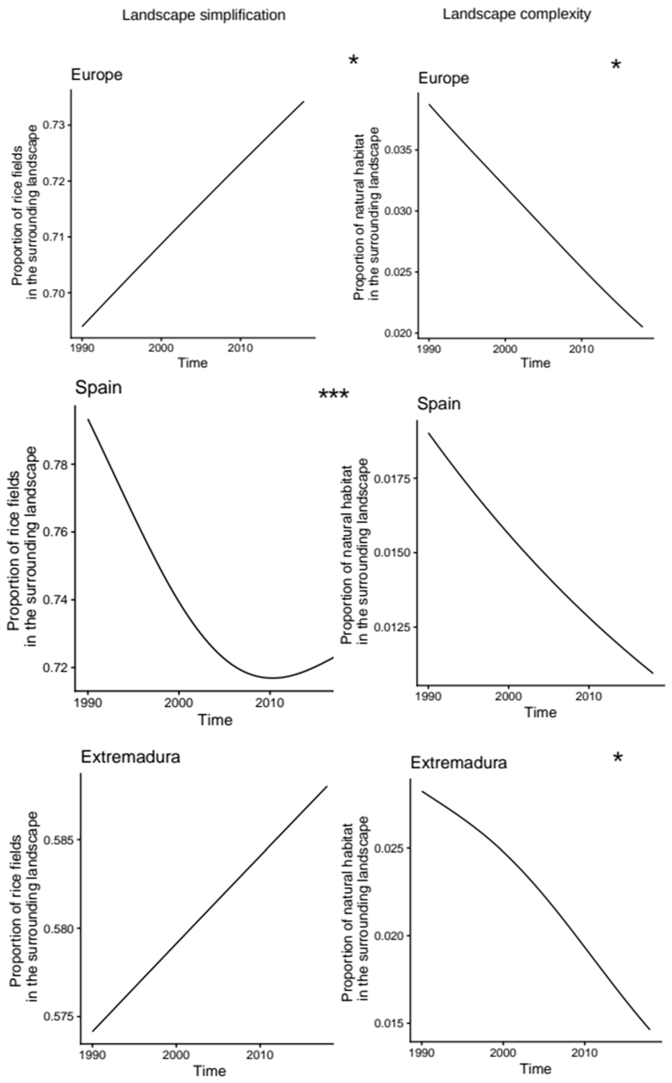
The final component of the results consists of temporal trend graphs that illustrate whether agricultural landscapes have become more simplified or more complex over the thirty-year study period. By showing directional trends—upward or downward—and calculating the percentage of change, these figures provide an integrated view of how agricultural systems respond to socioeconomic pressures, policy reforms and environmental constraints. Asterisks denote significance levels consistent with the tables—one for 0.05–0.01, two for 0.01–0.001 and three for <0.001—allowing visual alignment between statistical and temporal trends.
4. Discussion
Our results revealed marked differences in long-term landscape simplification and natural habitat complexity among spatial scales and crop systems. While Europe and Spain generally exhibited stable or declining trends in landscape simplification, Extremadura showed increasing simplification in several agricultural systems, highlighting the importance of regional context in shaping landscape trajectories. These findings suggest that agricultural landscape evolution is not driven by a single process but rather emerges from the interaction between crop specialization, land-use policies and local environmental conditions.
The overall pattern for total agriculture reveals profound contrasts between territories. Spain exhibited the strongest tendency towards landscape simplification, consistent with its substantial share of European Utilized Agricultural Area (UAA) [
21]. Extremadura shows an intermediate relationship, likely moderated by traditional multifunctional systems such as dehesas, which integrate agriculture, forestry and livestock while conserving natural habitat structure. Europe’s lower value reflects the greater heterogeneity of land-use practices among EU member states and the moderating role of northern and central European landscapes in diluting the intensity observed in southern regions. Complexity values reinforce this gradient: Europe’s strong significance indicates that natural habitats remain a major structural driver of the continental landscape, whereas Spain shows a similar but weaker pattern, and Extremadura lacks statistical support for such a relationship.
Temporal trends suggest that European and Spanish landscapes have progressively become less simplified, a pattern that may be associated with CAP reforms, ecological conditionality, and broad efforts to promote environmental sustainability, including circular economy initiatives, PDO certifications and the expansion of organic farming [
22]. In contrast, Extremadura displays increasing simplification, potentially reflecting broader land-use changes associated with irrigation development and agricultural transformation [
23]. Complexity trends show modest improvements in Europe and Spain—consistent with Natura 2000 and other restoration initiatives—while Extremadura experiences initial gains followed by a regression associated with intensified olive and rice cultivation [
16].
The contrasting trends observed in vineyard landscapes among spatial scales suggest a complex interaction between agricultural intensification, market dynamics and conservation policies. In Europe, moderate significance likely reflects sectoral policies and DO systems that help preserve cultural landscapes [
24], even though restructuring has historically prioritized productivity over environmental quality [
25]. In Spain, the very strong relationship between vineyards and simplification underscores the vulnerability of wine-growing landscapes to intensive models, despite recent efforts promoting traditional practices and ecological certification [
26,
27]. Market pressure and the abandonment of low-yield vineyards intensify spatial homogenization [
28], whereas organic viticulture and DO governance offer some counterbalancing forces [
29]. Extremadura, though non-significant statistically, exhibits trends consistent with increasing vineyard concentration within the landscape.
The olive grove results highlight the ecological tension between traditional high-diversity systems and emerging super-intensive models. In Extremadura, traditional olive groves function as biodiversity-rich agroecosystems, mimicking Mediterranean forest structure [
30]; more than 250,000 hectares are now affected by ongoing transitions toward more simplified and production-oriented agricultural systems [
31]. Complexity patterns in Spain confirm that natural habitats still structurally influence olive-growing areas, and numerous restoration projects emphasize how even minimal habitat recovery can positively affect biodiversity [
32]. Temporal patterns in Extremadura, however, reflect a structural shift from extensive to intensive plantations. This pattern highlights the importance of targeted conservation policies, particularly in areas where agricultural productivity and ecological resilience are both at stake [
33].
The rice system exhibited some of the clearest signals of landscape simplification, highlighting its ecological sensitivity. In Europe and Spain, strong simplification reflects the high spatial dominance of rice cultivation within flooded agricultural landscapes [
34]. Expansion is limited by strict agronomic requirements and environmental constraints, and although restoration initiatives exist, rice area in Spain has remained relatively stable due to expansion into new irrigated zones such as the Vegas del Guadiana [
35]. The ecological duality of rice is especially pronounced: while it creates artificial wetlands that benefit waterbirds, it also emits methane, involves intensive pesticide use and contributes to soil degradation. In Extremadura, agro-environmental measures implemented since 2004 [
36] have promoted more sustainable techniques, although adoption has been uneven. Temporal trends suggest persistent pressure towards landscape simplification and highlight the need for stronger incentives for sustainability.
From a management perspective, the observed differences among crop systems and spatial scales highlight the need for region-specific agro-environmental strategies. Future research should integrate additional landscape metrics and higher-resolution land-cover datasets to evaluate how changes in landscape composition and configuration jointly affect biodiversity and ecosystem services.
5. Conclusions
The multi-scale analysis revealed that agricultural landscape evolution differs substantially among crop systems and spatial scales. Landscape simplification was significant across most agricultural systems, particularly in Spain, whereas Extremadura displayed more heterogeneous responses, with significant simplification detected only in olive groves. Vineyard and rice systems showed the strongest associations with landscape simplification, highlighting the importance of crop-specific trajectories in shaping agricultural landscapes.
Landscape complexity exhibited weaker and more variable patterns than simplification, with significant relationships detected mainly at broader spatial scales. These findings suggest that natural habitats may exert a stronger structural influence on landscape patterns at continental and national levels than at regional scales, where agricultural dynamics appear to be more strongly shaped by local land-use processes.
Temporal analyses revealed contrasting trajectories among territories. Europe and Spain generally exhibited stable or declining trends in landscape simplification, whereas Extremadura showed increasing simplification and variable complexity trends. Overall, the findings indicate that agricultural landscape change is shaped by the interaction of crop type, spatial scale, and regional context, emphasizing the need to consider these factors when evaluating long-term landscape dynamics.
From a policy perspective, the results provide useful evidence for evaluating the long-term effects of successive CAP reforms on agricultural landscapes. The identification of contrasting landscape trajectories among crop systems and spatial scales may support decision-makers in designing region-specific agro-environmental measures that reconcile agricultural production with biodiversity conservation and ecological connectivity.
This study is based on the CORINE Land Cover database, whose spatial resolution may underestimate highly fragmented agricultural landscapes and small habitat patches. Moreover, the use of compositional indicators provides a broad characterization of landscape structure but does not explicitly account for configurational aspects such as patch connectivity or edge density. These limitations should be considered when interpreting the broad-scale patterns identified in this study.
Future studies should integrate higher-resolution land-cover datasets, additional landscape metrics and information on agricultural management practices to better understand the mechanisms driving landscape change across multiple spatial scales and to support more targeted landscape management strategies.