Article

Identifying Buildings Without Permits in Coastal Montenegro Using Deep Learning and Land Administration Modeling


by
Aleksandra Radulović
1,*,
Dubravka Sladić
1,
Miro Govedarica
1,
Arsenije Govedarica
2 and
Dušan Raičević
3
1
Faculty of Technical Sciences, University of Novi Sad, 21000 Novi Sad, Serbia
2
Advanced Geospatial Solutions (AGS), 21000 Novi Sad, Serbia
3
Municipal Authority of Bar, 85000 Bar, Montenegro
*
Author to whom correspondence should be addressed.
Land 2026, 15(7), 1276; https://doi.org/10.3390/land15071276
Submission received: 3 June 2026 / Revised: 12 July 2026 / Accepted: 15 July 2026 / Published: 16 July 2026
(This article belongs to the Special Issue Urban Planning Drives 3D City Development in Time and Space)

Abstract

In Montenegro, the registration of buildings constructed without permits largely depends on voluntary reporting by property owners, leading to incomplete and predominantly non-spatial records. Rapid urbanization, particularly in coastal areas, has increased the discrepancy between reported and unreported buildings without permits, challenging the effectiveness of existing land administration and cadastral systems. This study develops and evaluates an integrated geospatial framework for identifying unreported buildings without permits and incorporating them systematically into land administration workflows. The approach combines the analysis of high-resolution satellite and orthophoto imagery with the machine learning-based extraction of building structures (semantic and instance segmentation), which are then linked to existing cadastral and administrative records. The framework enables the identification of buildings that are unreported, previously reported cases, and complex situations requiring further verification, providing a basis for targeted administrative inspection. Additionally, the study proposes extending the current LADM (land administration domain model) country profile for Montenegro to accommodate automatically detected structures, their legal status, and associated data reliability. The results suggest that combining geospatial analysis with enhanced administrative modeling can support a more comprehensive, transparent, and data-driven management of buildings without construction permits, particularly in densely urbanized coastal regions. This approach demonstrates a practical pathway for improving the monitoring and documentation of unreported buildings in contexts where conventional reporting is incomplete or inconsistent.

1. Introduction

Real estate represents one of the most significant pillars of national economies, directly influencing public revenue, spatial development, investment security, and social stability. A transparent and legally compliant land administration is therefore essential for sustainable economic growth, effective spatial planning, and the protection of property rights. In this context, the completeness and reliability of cadastral records play a crucial role since they form the foundation for taxation, urban planning, infrastructure development, and legal certainty in real estate transactions.
Due to intensified and frequently uncontrolled urban development, particularly in coastal municipalities of Montenegro such as the Municipality of Bar, the number of buildings without permits has increased rapidly. The Law on the Legalization of Illegal Buildings from 2025 [1] obliges owners of buildings constructed without permits to report such objects to the geodetic authorities. For several years, the implementation of this regulation relied predominantly on voluntary self-reporting, with records often maintained in non-spatial formats, such as spreadsheet files. Only a subset of reported objects was subsequently surveyed and formally entered into the real estate cadaster, where they were annotated with legal restrictions indicating construction without a valid building permit. As a result, the official cadastral and administrative datasets only partially reflect the actual situation on the ground. This process has led to a growing discrepancy between the actual extent of construction without permits and the number of objects officially reported and registered. The lack of systematic detection mechanisms has resulted in incomplete cadastral records, reduced transparency, and limited institutional capacity to effectively manage and regularize buildings constructed without permits. This gap poses a serious challenge to land administration authorities and undermines evidence-based decision-making at both the local and national levels. The main goal of this paper is to address this challenge by proposing an automated and scalable geospatial framework for the detection, classification, and structured integration of buildings constructed without permits into the land administration system. The proposed approach leverages high-resolution orthophoto imagery and state-of-the-art deep learning techniques for building extraction and analysis. Convolutional neural network (CNN)-based models, particularly DeepLab and Mask R-CNN, have shown strong performance in building detection and segmentation tasks, either when applied individually or in combination. In this research, the DeepLab model was implemented due to its effectiveness in semantic segmentation and its ability to accurately represent complex roof structures and heterogeneous coastal environments. In contrast, Mask R-CNN (mask region-based convolutional neural network) is especially suitable for dense urban areas, as it enables the instance-level detection and precise delineation of individual building footprints. The use of these advanced algorithms provides the reliable identification and extraction of buildings from high-resolution orthophoto imagery.
The extracted building geometries were spatially integrated with cadastral parcels, existing records of reported buildings without permits, and official cadastral datasets. Through spatial overlay and rule-based analysis, buildings were classified into three categories: unreported candidate buildings without permits, candidate buildings located on parcels with legally registered or previously reported structures, and candidate buildings situated on so-called “gray-zone” parcels, where multiple structures exist but only some have been officially reported. These gray-zone cases are of particular importance, as they represent high-priority candidates for further administrative verification and targeted field inspection. The primary objective of the proposed framework is the detection of buildings without permits. Accordingly, at the AI inference stage, all outputs represent automatically detected candidate objects rather than administratively confirmed legal categories. Based on spatial and cadastral evidence, these candidate objects are interpreted within the same classification framework, while the final legal status is assigned only after completion of the formal administrative verification process through the geoportal and cadastral workflow, including field inspection where necessary.
The terminology used in the manuscript, which explicitly distinguishes between automatically detected candidate objects and administratively confirmed objects, is presented in Table 1.
In addition to the detection and classification framework, this study introduces an extension of the land administration domain model (LADM) [2] country profile for Montenegro that was previously developed by the authors [3,4]. The proposed extension incorporates new classes and attributes to represent automatically extracted building objects, detection confidence levels, legal status, source of identification (self-reported or automatically detected), and temporal characteristics. This extended LADM profile enables the structured and traceable integration of deep learning-derived spatial data into the real estate cadaster, bridging the gap between remote sensing-based detection and legal registration processes. By combining deep learning-based building extraction with an LADM compliant data model, the proposed solution offers a transparent and scalable approach to identifying unreported candidate buildings without permits. The proposed framework was designed based on standardized national datasets (cadaster, orthophoto imagery, and LADM-based data model) and uniform administrative and legal procedures applied across all coastal municipalities in Montenegro. It is expected that the proposed methodology is transferable to other coastal municipalities in Montenegro with minimal adaptation, given that the same data provider, data structure, legal framework, and similar urbanization patterns characterize these areas. This expectation is grounded in the homogeneity of data sources and regulatory environment rather than purely theoretical assumption. The proposed framework supports the broader modernization of land administration systems in rapidly developing urban and coastal regions.
The main contributions of this paper are as follows:
  • An integrated operational framework combining deep learning, spatial analysis, cadastral data and administrative records for identifying candidate buildings without permits.
  • A rule-based methodology for classifying detected buildings into unreported buildings, reported buildings without permits, and gray-zone buildings requiring administrative verification.
  • An extension of the Montenegrin LADM country profile supporting the management of automatically detected buildings and legalization procedures.
  • A geoportal-based administrative workflow enabling the visualization, verification, and integration of detected buildings into cadastral processes.
  • A real-world implementation and validation of the proposed framework using the Municipality of Bar, demonstrating its applicability for municipal land administration.
The paper is structured as follows. Section 1 provides an introduction, outlining the research motivation, objectives, and overall context of the study. Section 2 presents the methodological framework, a review of related work, and an overview of cadastral data and the relevant legal framework in Montenegro. Section 3 reports the results, introducing a geospatial and data-driven framework for identifying candidate buildings without permits in Montenegro. This section covers the deep learning-based detection of building footprints, spatial analysis and cadastral assessment of candidate buildings without permits, the proposed LADM country profile extension supporting the registration of buildings without permits, and the methodology validation through a geoportal for administrative verification and the integration of field inspection results. Section 4 provides the discussion, interpreting the findings and their implications, while Section 5 concludes the paper with the conclusions, summarizing the main contributions and outlining directions for future research.

2. Materials and Methods

2.1. Methodological Framework

The proposed methodological framework is shown in Figure 1. It integrates high-resolution remote sensing data, official cadastral records, and deep learning techniques to identify and classify buildings constructed without permits. The workflow begins with the acquisition of high-resolution orthophoto imagery and official cadastral data, which together provide the spatial and legal reference context for the analysis. The methodological framework consists of the following sequential steps:
  • Both orthophoto and official cadastral datasets undergo preprocessing and tiling to ensure spatial alignment, consistent resolution, and suitability for deep learning inference. Two deep learning approaches can be applied in parallel or separately: Mask R-CNN, for instance, level building detection and DeepLab for semantic segmentation. Using a dual approach enables both the precise delineation of individual building instances and robust extraction of built-up area, especially in dense urban areas.
  • The outputs of the previous step are refined through a building footprint refinement process, improving geometric accuracy and reducing segmentation noise. The refined building footprints are subsequently integrated with cadastral data and records of reported buildings without permits to support spatial comparison and attribution.
  • A spatial analysis step evaluates topological and spatial relationships between detected buildings, cadastral parcels, registered structures, and reported constructions without permits. Based on this analysis, a rule-based classification is applied to categorize buildings into three groups: unreported candidate buildings without permits, reported candidate buildings without permits, and gray-zone buildings requiring further verification due to incomplete or ambiguous data.
  • These categories are consolidated into a final class of buildings without permits, which serves as the basis for extending the national land administration domain model (LADM) country profile. The proposed extension supports the systematic registration and management of buildings constructed without permits.
  • The framework produces multiple operational outputs, including detected building footprints, legal status indicators, detection confidence attributes, LADM-compatible administrative records, and inspection-ready maps with priority lists. Together, these outputs provide a scalable, data-driven foundation for supporting land administration, enforcement, and regularization processes.

2.2. Related Work

Building detection from aerial imagery has become an important task in many areas such as urban planning, disaster management, cadastral mapping, etc. High-resolution orthophotos provide detailed information about the Earth’s surface, enabling the automatic extraction of objects such as buildings and houses. Therefore, in recent years, deep learning approaches based on convolutional neural networks (CNNs) have significantly improved the accuracy of object detection and extraction. Among the most commonly used approaches found in the literature and practice are semantic segmentation methods, such as U-Net [5] and DeepLab [6], and instance segmentation methods, such as Mask R-CNN [7]. Although these approaches share the goal of identifying buildings in imagery, they differ in methodology and output representation.
Semantic segmentation aims to classify every pixel in an image into a predefined class. In the case of building detection, each pixel is labeled as either “building” or “background”. The U-Net, introduced by Ronneberger et al. [5], is a widely adopted CNN architecture for image segmentation because of its U-shaped encoder–decoder structure, which combines contextual information from deeper layers with spatial details from earlier layers through skip connections. Skip connections between encoder and decoder layers enable the preservation of spatial information and improve segmentation accuracy. This design allows the model to capture both global context and fine object boundaries, making it particularly effective for extracting building footprints from orthophotos.
Another widely used model is DeepLabV3+, proposed by Chen et al. [6], which introduces atrous (dilated) convolutions and spatial pyramid pooling to capture multi-scale contextual information for improved semantic segmentation. The use of atrous spatial pyramid pooling enables effective multi-scale feature extraction while improving object boundary delineation. DeepLabV3+ can detect buildings of different sizes and shapes more effectively than simpler architectures, especially in complex urban environments where objects vary greatly in scale.
However, semantic segmentation methods have a limitation: they do not distinguish between individual objects belonging to the same class. When buildings are closely spaced or connected, these methods may produce a single merged region instead of separate building footprints. This can be problematic in applications such as cadastral mapping or urban analysis, where identifying individual buildings is important.
To address this limitation, instance segmentation methods such as Mask R-CNN are often used. Mask R-CNN (mask region-based convolutional neural network), introduced by He et al. [7], extends Faster R-CNN by adding a parallel branch for predicting segmentation masks for each region of interest (hence mask region-based CNN), enabling simultaneous object detection and precise segmentation. Region-based indicates that the model relies on region proposals (specific areas of an image likely to contain objects) rather than scanning the entire image all at once. Mask R-CNN extends object detection frameworks by predicting a bounding box, class label, and a pixel-level mask for each detected object. Unlike semantic segmentation, instance segmentation can differentiate between multiple objects of the same class. In the context of orthophoto analysis, Mask R-CNN can identify each building separately, even in dense residential areas. This makes it particularly suitable for applications where individual building delineation is required.
When comparing these approaches, semantic segmentation methods such as U-Net and DeepLab generally provide faster training and inference and are easier to implement for large-scale mapping tasks. They also tend to produce smooth and continuous building masks, which can be beneficial for extracting building areas. DeepLab usually performs better than U-Net in complex scenes because of its ability to capture multi-scale contextual features. On the other hand, Mask R-CNN provides more detailed instance-level information, including the separation of adjacent buildings. This advantage comes at the cost of higher computational complexity and longer processing times.
In summary, both semantic and instance segmentation methods are effective for building detection from orthophotos, but their suitability depends on the application requirements. Semantic segmentation models such as U-Net and DeepLab are well-suited for large-scale building extraction where pixel-level classification is sufficient. In contrast, Mask R-CNN is preferable when individual building instances need to be identified and analyzed separately. Therefore, the choice of method should be guided by the desired level of detail, computational resources, and the characteristics of the study area.

2.2.1. Building Footprint Extraction from High-Resolution Imagery

Building footprint extraction from remote sensing imagery has become an important research topic due to its applications in urban planning, cadastral management, smart cities, and environmental monitoring.
Recent advances in deep learning have significantly improved the accuracy and automation of building extraction from high-resolution aerial and satellite imagery. Huang et al. [8] proposed a large-scale framework for building extraction and generated China’s first sub-meter (0.5 m) building footprint dataset using deep learning techniques and a constructed training sample set. Their work demonstrated the potential of deep neural networks for nationwide building footprint mapping from very high-resolution imagery. Saadati and Hao [9] proposed AttUNet+, a high-fidelity building footprint extraction model designed for high-resolution aerial imagery. Their approach aimed to preserve extraction accuracy while reducing the computational complexity commonly associated with high-fidelity segmentation models.
Comparative studies have also contributed to understanding the strengths and limitations of different deep learning architectures. Qian et al. [10] performed a comparative analysis of several state-of-the-art deep learning methods for building footprint extraction, including U-Net, DeepLabV3, and Mask R-CNN, on high-resolution imagery. Their study highlighted the varying performance of semantic and instance segmentation approaches depending on urban landscape complexity and image characteristics. A comprehensive overview of recent deep learning approaches for building extraction was presented by Yuan et al. [11]. Their survey systematically reviewed topics such as representation learning, efficient data utilization, multi-source data fusion, and polygonal output generation, providing valuable guidance for selecting appropriate methods for specific building extraction tasks.

2.2.2. Semantic Segmentation Approaches

Semantic segmentation methods are widely used for pixel-level building extraction from remote sensing imagery. Among them, U-Net and DeepLabV3+ represent some of the most influential architectures.
U-Net, introduced by Ronneberger et al. [5], is a widely adopted convolutional neural network architecture for image segmentation. The model utilizes a U-shaped encoder–decoder structure consisting of a contracting path for contextual feature extraction and an expanding path for precise localization. Skip connections between encoder and decoder layers enable the preservation of spatial information and improve segmentation accuracy.
Building upon the original U-Net architecture, Abdollahi and Pradhan [12] developed an improved U-Net-based model for building extraction from aerial imagery. Their study compared the proposed architecture with several state-of-the-art models, including DeepLabV3, ResNet, and FractalNet, demonstrating improved performance for building object extraction. Pasquali et al. [13] proposed a structurally optimized U-Net-based approach for building footprint extraction from multispectral very-high-resolution satellite imagery. Their method improved classification performance while leveraging the advantages of encoder–decoder segmentation architectures.
DeepLabV3+, proposed by Chen et al. [6], introduced atrous convolutions and an encoder–decoder architecture to improve semantic segmentation performance. The use of atrous spatial pyramid pooling enables effective multi-scale feature extraction while improving object boundary delineation.
DeepLabV3+ has been successfully applied in several remote sensing studies. Ni et al. [14] combined deep learning and geographic information systems (GISs) to evaluate rooftop solar energy potential in dense urban environments. Their methodology employed DeepLabV3 for detecting rooftop obstructions from high-resolution satellite imagery while integrating building height data to analyze shading effects. Li et al. [15] proposed a framework integrating U-Net, DeepLabV3+, active learning strategies, and landscape characterization techniques to reduce the annotation effort required for CNN-based building extraction. Their work demonstrated the effectiveness of active learning in improving segmentation performance with fewer labeled samples. In another study, Li and Dong [16] developed a framework combining DeepLabV3+, transfer learning, active learning, and incremental learning for building footprint mapping. Their approach addressed one of the major challenges in remote sensing image segmentation, namely the requirement for large quantities of labeled training data and the high cost of annotation.

2.2.3. Instance Segmentation Approaches

In addition to semantic segmentation, instance segmentation approaches have become increasingly important for extracting individual building objects from remote sensing imagery. Mask R-CNN, introduced by He et al. [7], extends Faster R-CNN by adding a parallel branch for predicting segmentation masks for each region of interest, enabling simultaneous object detection and precise segmentation.
Several studies have adapted Mask R-CNN for building extraction tasks. Zhang et al. [17] proposed an improved Mask R-CNN-based method for efficient building extraction from high spatial resolution remote sensing imagery. Similarly, Han et al. [18] developed a building detection method based on Mask R-CNN for remote sensing images. Wang et al. [19] combined deep learning and UAV remote sensing imagery to develop a high-precision extraction method for traditional village buildings using Mask R-CNN as the core instance segmentation framework. Hou and Li [20] also applied Mask R-CNN for automatic building detection and feature extraction from UAV remote sensing images in urban areas. Hakim and Tsai [21] trained a Mask R-CNN model on multi-band satellite imagery for building footprint extraction and further applied geometric regularization techniques to simplify and align extracted building polygons according to dominant structural orientations.
The robustness and generalization capabilities of deep learning methods for building footprint extraction were investigated by Sakeena et al. [22], who compared SegNet and Mask R-CNN on proprietary and publicly available high-resolution satellite imagery datasets. Their analysis provided valuable insights into the performance of encoder–decoder and object detection architectures under varying conditions.

2.2.4. Detection of Buildings Without Permits

The detection of buildings without permits represents a growing research area motivated by the need for efficient urban monitoring and cadastral updating. Deep learning and remote sensing techniques have increasingly been employed for identifying unauthorized construction activities. Mehta et al. [23] applied a U-Net-based semantic segmentation approach with transfer learning for the detection of buildings without permits from optical satellite imagery. Their methodology demonstrated the effectiveness of transfer learning in improving feature extraction and segmentation performance.
Jiang et al. [24] proposed a multi-task learning framework for building footprint extraction that integrates historical cadastral maps with up-to-date remote sensing imagery. Their approach demonstrated the potential of combining historical cadastral information with deep learning for detecting building changes and inconsistencies. Jovanović et al. [25] proposed a methodology for the automatic detection of newly constructed, modified, or demolished buildings using satellite imagery and existing cadastral data. Their approach compared object-based and pixel-based image analysis techniques to support cadastral updating and the maintenance of building change registers.
Liu et al. [26] proposed a detection pipeline for buildings constructed without permits using high-tower cameras and an object detection model named IBDNet. Their model achieved superior performance compared to YOLOv10-N for building-related object monitoring. Although their approach differs significantly from aerial/satellite-image-based methodologies, it highlights the increasing importance of automated systems for detecting candidate buildings without permits.
Romano et al. [27] analyzed the broader issue of the construction of buildings without permits in Italy and discussed its implications for national land policy and urban management. Their work emphasized the complexity of managing buildings constructed without permits and the need for effective monitoring mechanisms.

2.2.5. Research Gap and Contribution

Existing research on building extraction has primarily focused on improving the accuracy of semantic and instance segmentation models, including U-Net, DeepLabV3+, and Mask R-CNN, using high-resolution aerial and satellite imagery. Other studies have investigated the detection of buildings constructed without permits through remote sensing and change detection techniques. Separately, research on the land administration domain model (LADM) has concentrated on standardized modeling of cadastral and administrative information. However, these research directions have largely evolved independently. Existing studies rarely address how automatically detected building footprints can be systematically linked with cadastral records, legalization applications, administrative procedures, and standardized land administration models to support operational decision-making by public authorities. Furthermore, few studies have demonstrated a complete workflow from deep-learning-based building detection to cadastral integration and administrative verification using real governmental datasets.
To address this gap, this paper proposes an integrated framework for identifying buildings without permits in the Municipality of Bar, Montenegro. The framework combines deep-learning-based building extraction from high-resolution orthophotos, spatial integration with cadastral records and legalization applications, rule-based identification of unreported and potentially unreported buildings without permits, an extension of the Montenegrin LADM country profile supporting automatically detected buildings and legalization workflows, and a geoportal-based environment enabling administrative verification and cadastral updating. Rather than introducing a new deep learning algorithm, the contribution lies in demonstrating how established AI techniques can be operationally integrated with standardized land administration models and administrative processes to support cadastral modernization.
Therefore, the proposed framework is designed as an operational workflow for coastal municipalities in Montenegro, where rapid tourism-driven urbanization has resulted in a large number of buildings requiring legalization and cadastral updating. Rather than introducing a new deep learning algorithm, the novelty lies in the direct integration of automated building detection with cadastral records, legalization applications, and the LADM-based country profile within a unified administrative workflow. By linking detected buildings directly to standardized land administration data models and cadastral processes, the framework significantly reduces the time and manual effort required to identify, classify, verify, and process buildings without permits, thereby accelerating legalization procedures and improving the efficiency and consistency of municipal land administration.

2.3. Cadastral Data and Related Laws in Montenegro

The cadastral system in Montenegro is regulated by the Law on State Survey and Real Estate Cadaster [28], together with a set of accompanying by-laws governing the maintenance, updating, and exchange of real estate data. This law defines the real estate cadaster as a unified public register that integrates spatial (geometric) and legal (attribute-based) information on land parcels, buildings, part of buildings and their associated rights holders, and is administered by the geodetic authority. The cadaster is maintained as a digital database and serves as a fundamental instrument for ensuring legal certainty in real estate transactions, as well as for supporting spatial planning, property taxation, and land management. The structure of cadastral data in Montenegro is conceptually aligned with the ISO 19152 land administration domain model (LADM) providing a coherent framework for linking legal rights, restrictions, and responsibilities with their corresponding spatial units. The LADM country profile in Montenegro has been published previously by authors [2,3,4,29]. Spatial datasets for buildings and parcels are published as WFS (Web Feature Service) layers, enabling standardized access and integration.
Widespread construction without permits has long posed a significant challenge to spatial development, legal certainty, and land administration in Montenegro, particularly in coastal municipalities, where strong tourism demand and rapid urbanization have driven extensive construction outside the approved planning and permitting frameworks. The presence of a large number of physically existing but legally unrecorded buildings has created serious discrepancies between the actual land use and cadastral records, undermining property transactions, spatial planning, and effective governance. In response to these challenges, the obligation to report and record buildings without permits in the cadaster is primarily regulated by the Law on the Legalization of Illegal Buildings [1], published in the Official Gazette of Montenegro No. 91/25 and in force since 14 August 2025, alongside the relevant provisions of the Law on Spatial Planning and Building Construction [30]. This legal framework requires the owners of buildings constructed without permits that are not yet registered in the cadaster to initiate the procedure for their registration and legalization within six months from the law’s entry into force, i.e., no later than 14 February 2026. A key prerequisite for initiating this procedure is that the building must be identifiable on official aerial photogrammetric or satellite imagery obtained by the state in July 2025, which serves as proof of the building’s existence during the legally relevant period. Failure to report a building constructed without permits within the prescribed deadline entails significant legal and economic consequences. Buildings that are not registered in the cadaster lose the right to legalization, cannot be entered into the real estate cadaster, and consequently remain without legal status. Such buildings are excluded from legal transactions, meaning that they cannot be lawfully sold, transferred, donated, inherited, or used as collateral (e.g., for a mortgage or loan). Furthermore, after the expiration of the registration deadline, the law authorizes competent inspection authorities to issue decisions ordering the removal (demolition) of buildings that have neither been registered nor legalized. In addition to potential financial penalties and misdemeanor sanctions, unregistered buildings remain outside the systems of spatial planning, taxation, and legal certainty in the long-term, resulting in a substantially reduced market value.
The Geodetic Authority of Montenegro encourages citizens who own buildings constructed without permits to report them for registration. Since 2017, such reports have been recorded in Excel (XLS) files and were subsequently processed if the necessary permits for the buildings were obtained. Each year, a new XLS file was created to record submitted applications, containing information on the applicant, submission date, municipality, cadastral municipality, real estate folio number, parcel number, building area, intended land use, etc.
In practice, the submitted data were sometimes incomplete, particularly with respect to key identifiers such as the cadastral municipality and parcel number, which are essential for accurately locating and verifying the reported building. The absence of these critical attributes complicated the analysis of orthophoto imagery, as it became difficult to reliably identify whether a reported structure corresponded to an actual object visible in the imagery. Figure 2 illustrates an example of such a table, highlighting a case in which the applicant did not provide sufficiently detailed information to enable precise spatial identification. In such cases, it was necessary to visit the site, and together with the applicant, identify the object. Nevertheless, this represents a very small percentage of records (6.4%), so the majority of data can be linked to parcel geometry, allowing for the identification of parcels containing reported buildings without permits.

3. Results

3.1. Geospatial and Data-Driven Framework for Identification of Candidate Buildings Without Permits in Montenegro

A geospatial and data-driven framework is introduced to support the identification of buildings without permits in Montenegro through the integration of spatial analysis and advanced computational techniques. The framework combines deep learning-based building footprint detection with cadastral and legal data to enable systematic comparison between observed building patterns and officially registered records. By linking remote sensing data, cadastral information, and administrative processes, the approach facilitates efficient large-scale identification and the preliminary assessment of candidate buildings without permits.

3.1.1. Deep Learning-Based Detection of Building Footprints

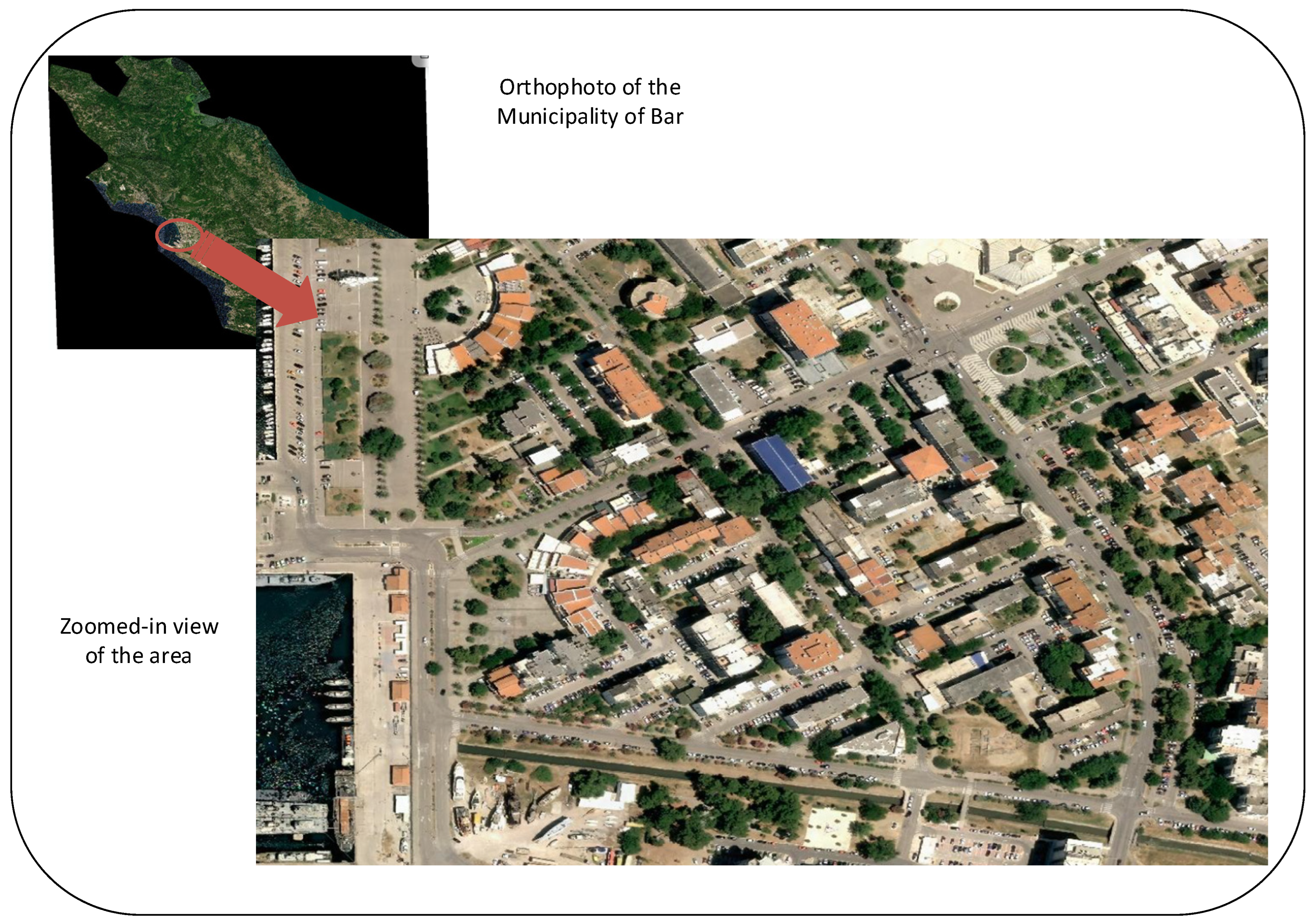
Prior to the development and training of the detection models, an orthophoto of the Municipality of Bar (Figure 3) was created from high-resolution aerial imagery. The orthophoto was produced through photogrammetric processing and geometric correction of the aerial images, resulting in a spatial resolution range of 15 cm per pixel, depending on the flight altitude and terrain characteristics. This high-resolution orthophoto provided the detailed visual information necessary for the accurate identification and delineation of buildings. The generated orthophoto served as the primary input to deep learning models for detecting candidate buildings without permits.
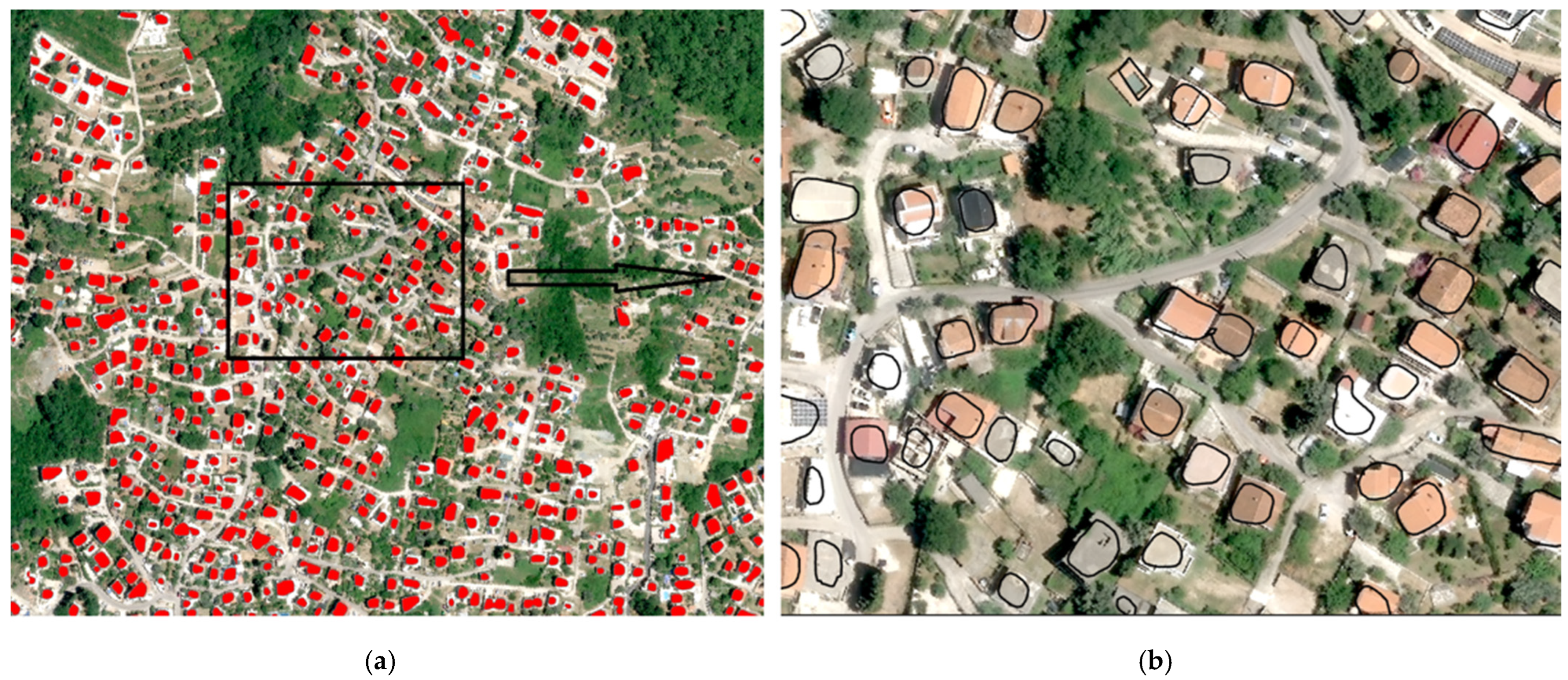
Following creation of the orthophoto, the selection of the most suitable deep learning approach for our task of building detection was performed by comparing the three most common methods (U-Net, DeepLab, Mask R-CNN). We conducted a conceptual comparative evaluation of these three deep learning architectures using an orthophoto of the Municipality of Bar. Preliminary experiments were conducted using U-Net, DeepLabV3, and Mask R-CNN on representative subsets of the study area to assess their suitability for the proposed application. Based on these preliminary experiments and the evidence reported in the literature, DeepLabV3 was selected for complete municipality-scale training, optimization, and evaluation. Consequently, the results presented in the remainder of this paper refer exclusively to the DeepLabV3 model. The models were assessed in terms of detection accuracy, segmentation quality, and computational efficiency. Table 2 shows results of the conceptual comparative evaluation of these three methods for building detection in orthophoto imagery. Evaluation results showed that while Mask R-CNN achieved precise instance-level detection, it required significantly higher computational resources and processing time. U-Net provided satisfactory segmentation results but demonstrated lower robustness in complex urban environments. DeepLab achieved the best balance between processing speed and detection performance, delivering sufficiently high accuracy while maintaining efficient inference times. Based on these findings, DeepLab was identified as the most suitable architecture for the practical large-scale detection of buildings without permits. Connected regions where we had multiple buildings in a row did not impose an issue since the buildings without permits were detected by overlapping with the official digital cadastral plan. Figure 4 shows the result of semantic segmentation using DeepLab. This example shows detected buildings in a small area of the cadastral municipality of Šušanj, which is part of the Municipality of Bar.
All experiments were conducted on a high-performance workstation equipped with an Intel Core i9 processor, 64 GB of RAM, and an NVIDIA RTX-series GPU with dedicated CUDA support for deep learning computations. The models were trained and evaluated under identical conditions to ensure a fair comparison. Training was performed using the ArcGIS Pro 3.5 Train Deep Learning Model tool following the standard ArcGIS deep learning workflow. Training samples were generated using the Export Training Data for Deep Learning tool from the orthophoto and building footprint polygons derived from the digital cadastral plan. A single dataset of image chips of 512 × 512 pixels was created and used for model training. Approximately 10% of the generated image chips were automatically reserved for validation, while the remaining samples were used for training. The learning rate was automatically determined by the ArcGIS Pro learning-rate finder, the batch size was automatically estimated according to the available GPU memory, and default data augmentation procedures, including random cropping, rotations, flips, brightness, contrast, and zoom transformations, were applied. The maximum number of epochs was set to 100, however, the Stop Training option was enabled, allowing the training process to terminate automatically when further improvement in the monitored validation metric was no longer achieved. Consequently, training converged after 16 epochs, and the best-performing model was retained automatically.
DeepLabV3 was configured for a maximum of 100 epochs, but training terminated automatically after 16 epochs because the early stopping criterion was met, achieving an overall detection accuracy of 93.34% while maintaining relatively fast training and inference times. The training dataset included 33,150 building footprints obtained from the digital cadastral plan for the Municipality of Bar. As a backbone model, ResNet-101, a 101-layer deep neural network, was used. Mask R-CNN was also configured for a maximum of 100 epochs with the early stopping criterion and achieved a slightly higher accuracy of around 94.5% due to its instance segmentation capabilities. However, it required a substantially longer processing time and higher GPU memory consumption. Although Mask R-CNN provided more detailed object delineation, DeepLab demonstrated a better balance between computational efficiency and sufficiently high accuracy, making it more suitable for the large-scale detection of buildings without permits.
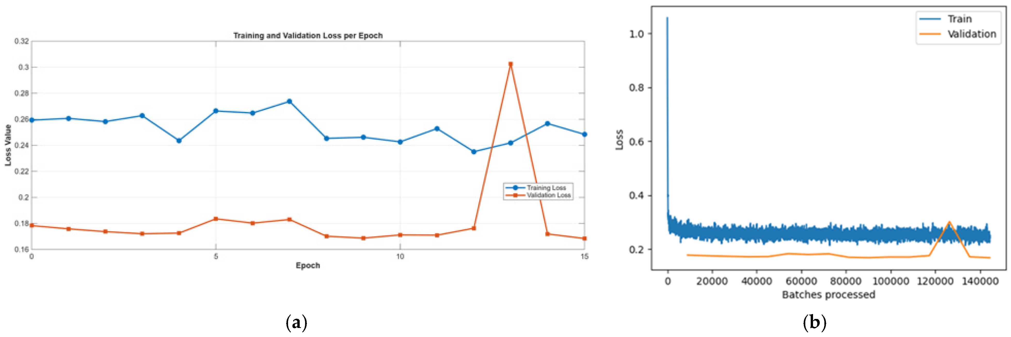
Figure 5 shows the loss function graph that tracks the model error during training through the blue (Train) and orange (Validation) curves. The model showed relatively stable training and validation behavior during the 16 epochs, indicating that the learning process was generally successful without severe overfitting. The validation loss decreased from 0.1783 in epoch 0 to its lowest value of 0.1684 in epoch 15, while the accuracy gradually improved from 92.89% to 93.34%. This steady improvement suggests that the model was able to learn meaningful spatial and semantic features from the dataset. Although set to 100 epochs, the model stopped improving after 15 epochs, and the training was successfully completed.
The Dice coefficient, which is more important for segmentation quality than overall accuracy, fluctuated considerably throughout training, achieving values around 0.6–0.7, which is considered moderate to good segmentation quality. The oscillation of Dice values indicates that the model had difficulties achieving consistent object boundary segmentation, despite maintaining high pixel accuracy, and segmentation boundaries were still imprecise. This is likely due to class imbalance, insufficient training data quality, complex urban textures, shadows, vegetation cover, stone structures, or outdated annotations (old ruined buildings covered in vegetation which are still registered in cadastral plan). However, these imprecise boundaries did not disrupt our primary task of detecting candidate buildings without permits because we overlapped the detected polygons with polygons from the cadastral plan.
The training loss remained relatively stable between 0.23 and 0.27, while the validation loss mostly stayed within the range of 0.168–0.183. However, epoch 13 showed a sudden spike of validation loss to 0.3027, accompanied by a slight drop in accuracy and Dice score. The temporary increase in validation loss around epoch 13 and the oscillation of the Dice coefficient are likely related to the heterogeneous characteristics of the study area, including dense urban areas, vegetation, rocky coastal terrain, buildings with diverse roof characteristics, and inconsistencies between the orthophoto and cadastral reference data. Some outdated cadastral records also introduced label inconsistencies, contributing to fluctuations during optimization. Since the validation metrics recovered in subsequent epochs and no sustained deterioration in performance was observed, we interpreted this behavior as temporary optimization instability rather than evidence of overfitting.
Overall, the model demonstrates good generalization capability and stable convergence. The final accuracy above 93% indicates reliable pixel classification performance, while a Dice coefficient around 0.65 suggests moderate segmentation quality with room for improvement in object delineation. Further improvements could be obtained through additional data augmentation, better class balancing, improvement of annotation quality, etc.
Additional evaluation metrics such as IoU, precision, recall, F1-score, inference time, GPU memory consumption, and object-level detection statistics were not systematically collected during model development. Similarly, an independent municipality-wide ground-truth dataset suitable for object-level quantitative evaluation is not available, as the existing cadastral records themselves constitute the official reference data and contain known inconsistencies and outdated building geometries. However, we calculated the precision, recall and F1-score for two cadastral municipalities (Kunje and Šušanj) containing around 4000 buildings, which is approximately 10% of buildings, using detected and ground-truth data. The ground-truth dataset was developed using a digital cadastral plan that is mostly accurate, supplemented and corrected by manually vectorized data. Object-based evaluation was performed in ArcGIS Pro using a spatial matching procedure. Predicted building polygons were compared with reference cadastral footprints using a one-to-one spatial join based on maximum intersection-over-union (IoU). True positives were defined using an IoU threshold of 0.5. Precision, recall, and F1-score were subsequently computed. Given the calculated true positives (TP) = 4014, false positives (FP) = 131, false negatives (FN) = 113, the calculated values were as follows: precision was 0.968 (96.84%), recall was 0.973 (97.26%), and F1-score was 0.971 (97.05%). These results indicate an excellent object-level building detection performance for the combined cadastral municipalities of Kunje and Šušanj, with both precision and recall above 96% and an overall F1-score of approximately 97.1%, demonstrating highly reliable building detection. Manual visual inspection of all cadastral municipalities proved this reliability.
Several challenges were identified during the training and evaluation process, primarily related to the quality and temporal consistency of the reference data. Some outdated cadastral data included old or ruined structures that had since become overgrown by dense forest vegetation. As a result, the models learned features associated with these obsolete building locations, which occasionally caused false positive detections within forested areas where no actual buildings existed. In addition, certain natural objects such as large rocks and exposed rocky surfaces were incorrectly classified as buildings. This misclassification occurred because some rocks exhibited spectral characteristics, color patterns, and geometric shapes similar to rooftops or man-made structures in the imagery. These issues highlight the importance of using up-to-date training datasets and incorporating additional contextual or multispectral information to improve the discrimination between buildings and visually similar natural features. Manual correction was performed as a post-processing step to remove false-positive detections, primarily consisting of small polygons and natural features such as rocks that exhibited spectral and geometric similarity to buildings in the orthophoto imagery. In addition, a minimum area threshold was introduced to automatically filter out very small detected polygons, while the remaining cases were manually reviewed and corrected by operators. The overall observed detection error rate was approximately 8%, which is considered acceptable given the presence of visually similar rocky and heterogeneous coastal terrain typical for the study area. This value represents the difference between the total number of automatically detected objects for the Municipality of Bar and the final number of objects retained after manual correction and the automatic removal of small polygons. Furthermore, all remaining ambiguous cases were subject to operator validation through field inspection and comparison with owners during the legalization procedure, which further reduced uncertainty in the final dataset.

3.1.2. Spatial Analysis and Cadastral Assessment of Candidate Buildings Without Permits

For the purpose of identifying buildings without permits, existing datasets and detected buildings were collected and prepared for spatial analysis.
The existing datasets included alphanumeric records from the real estate cadaster database, parcel and building geometries from the digital cadastral plan (DCP), and Excel tables containing applications for building legalization. Due to the lack of synchronization between building geometries in the digital cadastral plan and the alphanumeric cadastral records, discrepancies exist because updates in these two data sources were not performed simultaneously. Consequently, some buildings recorded in the database are buildings without permits entered after processing legalization applications and assigned annotations indicating that the building lacks permits. These include buildings without occupancy permits, without construction permits, and buildings exceeding the permitted construction parameters. Additionally, some buildings were added to the digital cadastral plan after application submission but were not recorded in the real estate cadaster database. Parcel data in the digital cadastral plan were largely harmonized with the alphanumeric records.
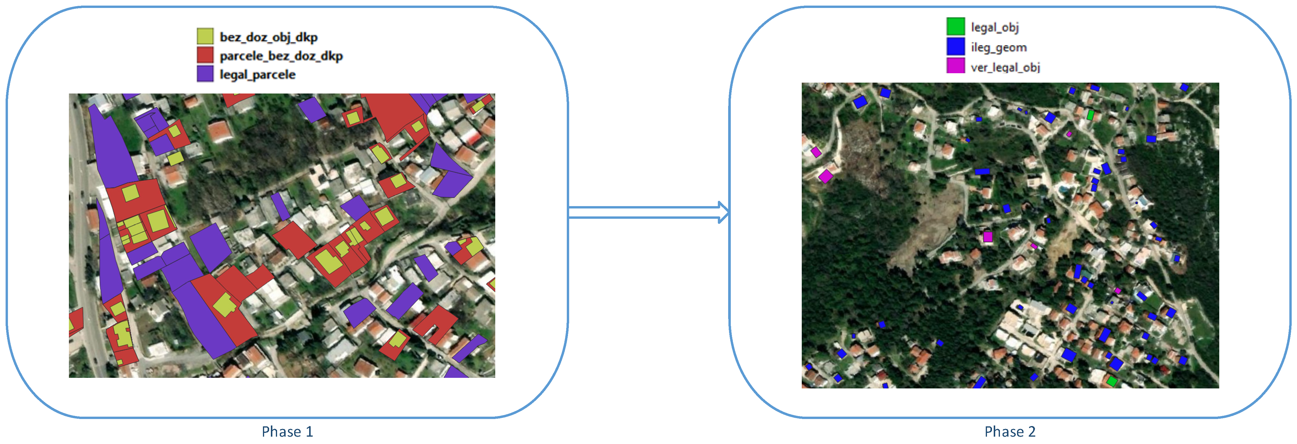
Because of these inconsistencies, the identification of buildings without permits was carried out in two phases (Figure 6). The first phase involved the preparation of vector datasets based on the previously described data sources. As a result, three layers were generated.
The first layer is a vector layer containing building geometries for which annotations exist in the real estate cadaster database, indicating that they were reported as buildings without permits (bez_doz_obj_dkp). Buildings from the digital cadastral plan were selected when they shared the same parcel number, subparcel number, building number, and cadastral municipality identifier as records in the database. During the selection process, additional attributes from the database were attached, such as building use, number of floors, real estate folio number, and annotation description.
The second layer consists of parcels containing buildings with recorded annotations indicating missing permits in the real estate cadaster (parcele_bez_doz_dkp). Due to inconsistencies in building data, some buildings entered in the database with annotations did not have corresponding geometries in the digital cadastral plan. For such cases, the parcels on which these buildings are located were extracted. This layer was created by selecting parcel geometries from the digital cadastral plan according to parcel number, subparcel number, and cadastral municipality identifiers describing parcels containing buildings built without permits.
The third layer represents parcels for which applications for the legalization of buildings without permits exist in Excel files (legal_parcele). In this case, it was not possible to create a building layer because buildings do not receive official building numbers during the application process, and in most cases, are not yet mapped in the digital cadastral plan. This layer was generated by extracting parcel geometries based on cadastral municipality, parcel number, and subparcel number from Excel documents while also attaching attributes recorded in the Excel tables.
These layers were used in combination with buildings detected using deep learning algorithms in order to determine whether a detected building had previously been reported as a building without permits or had not been reported at all. The datasets were published as a web service on the geoportal of the Municipality of Bar [31].
Afterward, Phase 2 was conducted. In this phase, the layer of buildings detected using deep learning algorithms was added to the analysis. Following the detection process, the obtained results were cleaned. Particularly in forested areas, the model occasionally detected buildings where none existed because the cadastral input vectors contained demolished buildings or buildings obscured by tree canopies. These situations were resolved through a combination of the automatic deletion of very small polygons and manual correction in forested areas. Since the number of such polygons was relatively small, the selected cleaning procedure provided satisfactory results within an acceptable processing time. The boundaries of detected buildings were refined using an edge-smoothing algorithm.
The second phase was conducted separately for each cadastral municipality in order to continuously monitor and validate the results at every processing step. Finally, the datasets were merged for the entire Municipality of Bar. Spatial queries were executed using the PostGIS extension of the PostgreSQL database management system. The main spatial operators included ST_Disjoint, ST_Intersects, and ST_Within, together with attribute matching using cadastral municipality identifiers, parcel numbers, subparcel numbers, and building identifiers. The classification rules are summarized as follows:
  • For each detected building polygon B
  • ST_Intersects (B, DCP_Buildings)
    YES → building already represented in DCP
    NO → continue
  • ST_Intersects(B, Parcels_with_registered_buildings_without_permits)
    YES → Reported candidate building
    NO → continue
  • ST_Intersects(B, Parcels_with_legalization_applications)
    YES → Reported candidate building
    NO → continue
  • ST_Disjoint(B, all previous datasets)
    YES → Unreported candidate building
  • Partial overlap, inconsistent parcel assignment, merged polygons, or missing DCP geometry
    → Gray-zone candidate building.
ST_Disjoint was used to identify detected building polygons that had no spatial relationship with buildings already represented in the Digital Cadastral Plan, parcels containing registered buildings without permits, or parcels included in legalization applications. These objects were classified as unreported candidate buildings. ST_Intersects was used to associate detected buildings with cadastral parcels, registered buildings, and legalization records. ST_Within was applied where complete containment within a cadastral parcel or building geometry was required during parcel attribution.
The first layer represents the set of buildings reported as buildings without permits. From the set of detected buildings, buildings that were not included in the digital cadastral plan building layer but were located on parcels for which buildings had been reported in the legalization process were extracted. This layer contains reported candidate buildings without permits (legal_obj).
Second, buildings that had not been reported in any record were identified using the spatial disjoint operator. From the set of detected buildings, buildings that did not appear in the DCP building layer, were not recorded in the database, were not located on parcels containing buildings with annotations indicating missing permits, and were not located on parcels reported in the Excel legalization tables were extracted. This layer contains un-reported candidate buildings without permits (ileg_geom).
The third layer represents the so-called “gray zone” consisting of buildings extracted from the set of detected buildings that are not included in the digital cadastral plan building layer, are not included in the set of buildings annotated as being without permits, and do not belong to either the unreported or reported building categories. This layer contains buildings that are probably without permits (ver_legal_obj), although their actual status must be individually verified. During building detection, if buildings are located adjacent to one another, the model may detect only a single polygon spanning multiple parcels. Furthermore, due to image acquisition angles, roof geometries may partially overlap neighboring parcels, leading to duplicated geometries during parcel attribute assignment using the spatial intersect operator. In such situations, if one parcel contains a reported building while the adjacent parcel does not, the latter building may not belong to either of the first two categories. This layer may also contain legal buildings that are registered in the cadaster but not represented in the digital cadastral plan. Therefore, mandatory verification is required for this layer during the legalization process. Buildings intersecting multiple parcels were treated as a single detected geometry while maintaining references to all intersected parcels. Minor roof overhangs extending across neighboring parcels were resolved through parcel assignment based on the largest intersected area. No additional buffer distance or predefined overlap threshold was applied. When DeepLab produced a single polygon covering several adjacent buildings, the geometry was retained as one candidate object and resolved during administrative verification. Multiple legalization applications referring to one multi-story residential building were treated as a single detected geometry linked to multiple administrative records. Buildings registered in the cadastral database but lacking geometry in the digital cadastral plan were assigned to the gray-zone candidate category and verified during the cadastral updating process. Buildings with inconsistent geometry (partial overlaps between detected polygons and DCP buildings) were also assigned to the gray-zone candidate category for subsequent administrative verification.
All three layers initially contained only geometries; therefore, parcel attributes such as cadastral municipality, parcel number, and subparcel number were added using the spatial intersect operator. The layers were then integrated into a single dataset, where each feature was assigned a classification code and additional fields intended for further processing by operators involved in the legalization procedure, such as building identification numbers and case file identifiers from the cadastral database linking each building to the corresponding legalization procedure.
Table 3 presents the statistics on the number of buildings by cadastral municipality. For example, the cadastral municipality of Popratnice is a small cadastral municipality with extensive forested areas and no legalization applications. It can be observed that significantly fewer buildings are recorded in the database than are represented in the digital cadastral plan. The cadastral municipality of Kunje is larger, and here, the opposite situation can be observed, with more buildings recorded in the database than in the digital cadastral plan. The number of legalization applications was significantly higher than the number of detected buildings in the three previously mentioned categories because applications are submitted under the names of applicants; therefore, a single building may correspond to multiple records, particularly in the case of multi-story residential buildings containing apartments. The cadastral municipality of Novi Bar was the largest, and in this case, there were no major discrepancies between the number of buildings in the database and in the plan. The numbers of detected buildings in the three categories represent the number of unique geometries assigned to each category. When combined with parcel information, even higher numbers were obtained due to connected buildings.
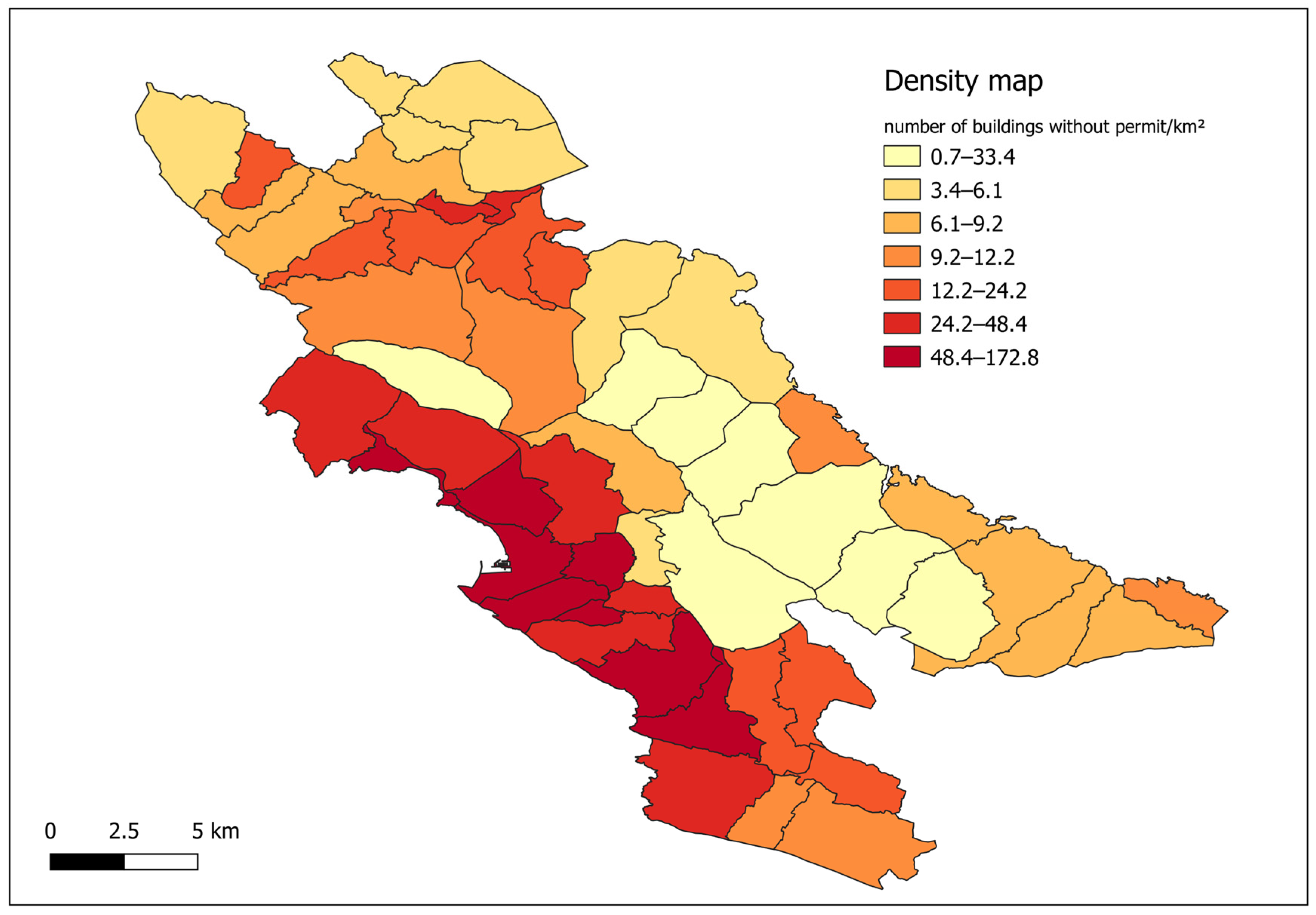
To enable a comparison between cadastral municipalities of different sizes, a density indicator was additionally calculated as the total number of candidate buildings without permits (i.e., the sum of unreported candidate buildings, reported candidate buildings, and gray-zone candidate buildings) divided by the area of each cadastral municipality (candidate buildings per km2). This normalized indicator provides a more objective measure of the spatial concentration of candidate buildings without permits than absolute counts alone.
The results indicate considerable spatial variation across the Municipality of Bar. For example, Novi Bar exhibited the highest density (120 candidate buildings per km2), reflecting intensive urban development and the concentration of buildings in the municipal center. Kunje showed a moderate density of 32.4 candidate buildings per km2, while Popratnice had a considerably lower density (3.9 candidate buildings per km2), which is consistent with its predominantly forested landscape and limited development. The density indicator therefore highlights areas where administrative verification and legalization activities may require higher priority.
The total number of detected unreported candidate buildings without permits as 6887 within the Municipality of Bar, while the number of reported buildings without permits was 1718. The number of probably unreported buildings without permits was 451 and requires additional verification. These figures represent detected polygons; however, considering situations where multiple connected buildings are represented by a single polygon, the actual numbers are likely even higher.
For the entire Municipality of Bar, covering an area of 505.21 km2, a total of 9056 candidate buildings without permits were identified, corresponding to an overall density of 17.92 candidate buildings per km2. This indicator provides a normalized measure that facilitates comparison with other municipalities and supports the prioritization of inspection and legalization activities.
Figure 7 illustrates the spatial distribution of the density indicator across all cadastral municipalities in the Municipality of Bar. The map revealed clear spatial differences, with the highest densities concentrated in urban and coastal cadastral municipalities, while inland and predominantly forested areas exhibited substantially lower densities. Such visualization supports the identification of priority areas for administrative verification, field inspection, and legalization activities, providing decision-makers with an intuitive overview of the spatial distribution of candidate buildings without permits.

3.2. LADM Country Profile Extension to Support the Registration of Buildings Constructed Without Permits

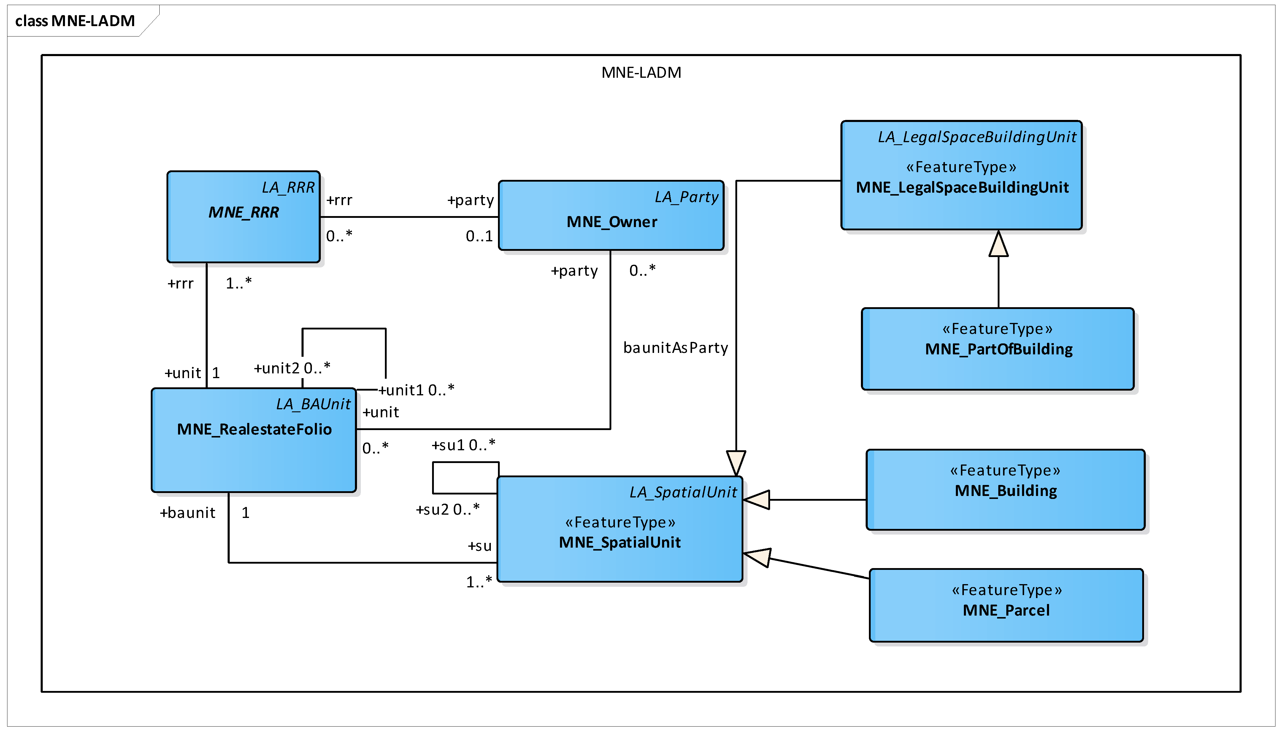
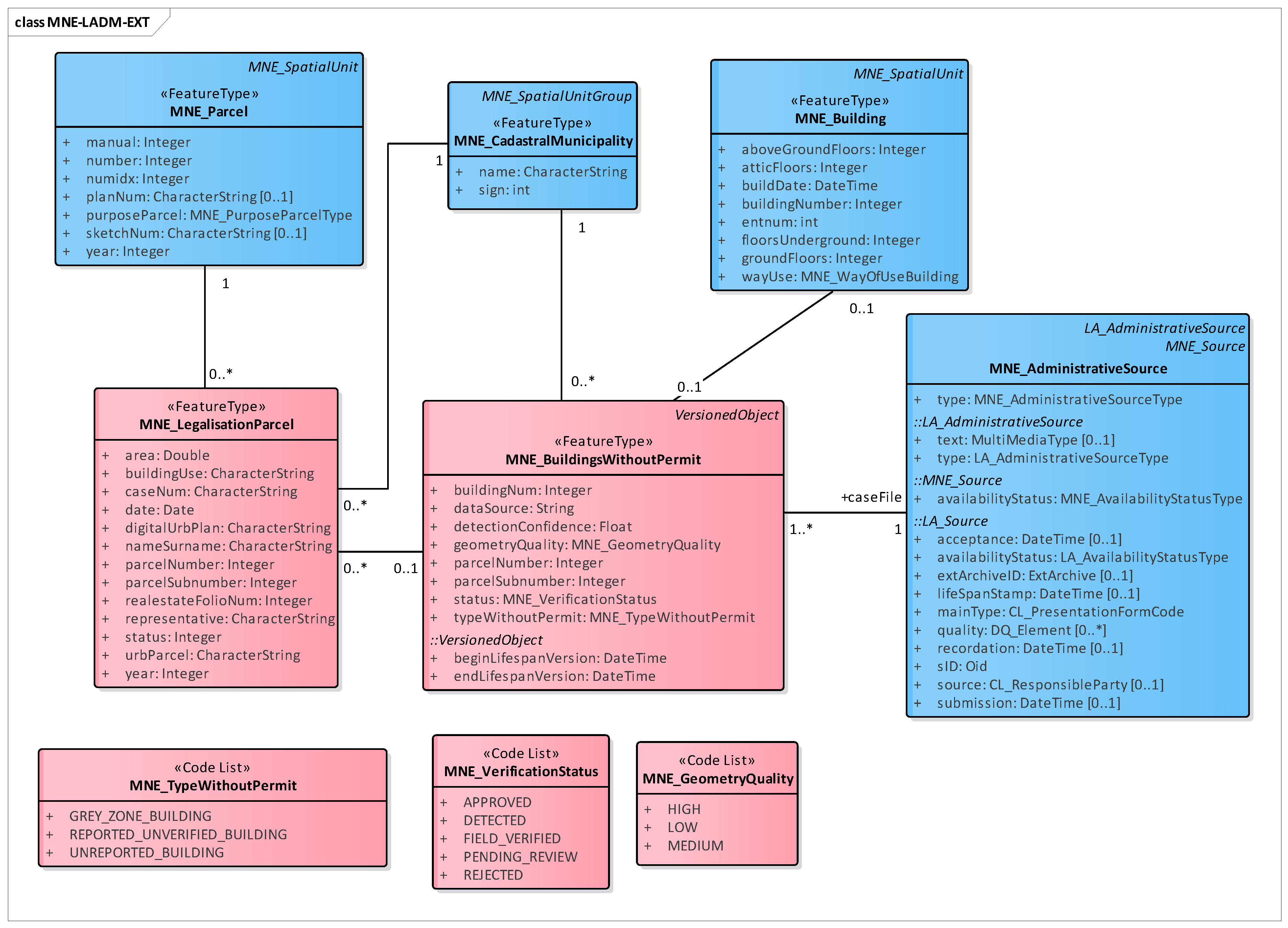
The process of legalization and detection of candidate buildings without permits does not end with the creation of data layers generated in the previous section. These layers represent input data that must be further processed through administrative case management procedures. After successful completion of the legalization process, the verified data are registered in the real estate cadaster database and incorporated into the digital cadastral plan. In addition, the data may also be used in procedures related to the correction and updating of existing records within the real estate cadaster database or the digital cadastral plan. Therefore, it is necessary to extend the data model in order to support the integration of categorized detected objects and legalization requests, thereby providing a basis for the efficient implementation of the legalization process. The introduction of new classes is motivated by the need to explicitly represent automatically detected and pre-validated spatial objects that are not yet part of the legally confirmed cadastral system. Existing LADM classes primarily represent legally valid and officially registered spatial units, while the proposed extensions enable the modeling of intermediate, uncertain, and machine-derived building objects within the legalization workflow. The domain model for the real estate cadaster in Montenegro has been presented in previous work by the authors [3,4]. Figure 8 shows the classes of the Montenegrin profile. Figure 9 highlights the extensions to the Montenegrin profile, where the original profile classes are shown in blue, and the classes introduced to support the legalization of buildings without permits are shown in pink.
The extracted set of classes from the Montenegrin profile includes the core classes MNE_SpatialUnit, MNE_Owner, MNE_RRR, and MNE_RealestateFolio, together with derived classes such as MNE_Parcel, MNE_Building, MNE_PartOfBuilding, MNE_CadastralMunicipality, and MNE_AdministrativeSource. These classes describe the spatial, legal, and administrative structure of the Montenegrin cadastral system in accordance with the principles of the land administration domain model (LADM). The MNE_SpatialUnit class represents cadastral spatial objects, including parcels, buildings, parts of buildings, utility infrastructure, and related spatial entities. To provide a more precise representation of cadastral objects, this class was specialized into subclasses such as MNE_Parcel for cadastral parcels, MNE_Building for registered buildings, and MNE_PartOfBuilding for individual building units, such as apartments or business premises. The MNE_Owner class describes natural and legal persons connected to cadastral objects, while the MNE_RRR class models rights, restrictions, and responsibilities related to ownership, use, and legal limitations. Administrative and registration information is organized through the MNE_RealestateFolio class, which links legal and spatial records within the cadaster. The MNE_CadastralMunicipality class defines cadastral municipalities as territorial units used for cadastral administration. The MNE_AdministrativeSource class contains official documents and records that serve as the legal basis for cadastral changes and registrations, including contracts, decisions, permits, survey documentation, and office case management records related to administrative procedures.
As an extension of this model, the classes MNE_LegalizationParcel and MNE_BuildingsWithoutPermit were introduced, together with code lists MNE_TypeWithoutPermit, MNE_VerificationStatus, and MNE_GeometryQuality. These classes are designed as domain-specific extensions rather than direct specializations of existing LADM classes, since they represent pre-legalization, automatically detected spatial objects that are not yet part of the legally validated cadastral system. This distinction allows for the explicit modeling of uncertainty, detection-derived geometry, and administrative workflow states. The MNE_LegalizationParcel class is intended for recording legalization applications and is linked to cadastral parcels and cadastral municipalities. It stores information submitted by applicants, including personal data (nameSurname), parcel information (parcelNumber, parcelSubnumber), real estate folio data (realestatefolioNum), representative information (representative), application date and year (date, year), as well as the area and intended use of the building (area, buildingUse). Additional information related to the digital urban plan and urban parcel can also be recorded when available (digitalUrbPlan, urbParcel). During the implementation of the legalization process, additional attributes are assigned, including the legalization status (status), administrative case number (caseNum), and references to detected candidate buildings without permits stored within the MNE_BuildingsWithoutPermit class. These detected objects are described using cadastral municipality information, parcel information (parcelNumber, parcelSubnumber), the corresponding category type (typeWithoutPermit), and verification status (status). The three categories of candidate buildings are defined through the MNE_TypeWithoutPermit code list. The MNE_TypeWithoutPermit code list has been refined to include strict semantic definitions of categories (unreported building, reported unverified building, gray-zone building), ensuring consistent interpretation within administrative and cadastral processes. The status attribute takes its values from the verification status code list (MNE_VerificationStatus), which supports the explicit modeling of administrative workflow transitions, including detection, field verification, approval, rejection, and pending review. The building number attribute (buildingNum) is intended to be populated after the successful completion of the legalization procedure, once the building is officially registered in the real estate cadaster database and added to the digital cadastral plan. To support uncertainty and data quality assessment, the MNE_BuildingsWithoutPermit class includes additional attributes: detectionConfidence (0–1), dataSource (e.g., DeepLab, Mask R-CNN, manual digitization, cadastral update), and geometryQuality (MNE_GeometryQuality), enabling assessment of the reliability of automatically extracted objects. MNE_GeometryQuality is defined as a code list used to describe the positional and geometric accuracy of extracted building footprints, ranging from low to high quality depending on the reliability of the input data and post-processing refinement.
Temporal consistency is ensured through inheritance from the LADM VersionedObject class, which provides beginLifespanVersion and endLifespanVersion attributes, enabling full lifecycle tracking of detected objects from initial detection to final cadastral integration or removal.
Finally, the relationship with the MNE_AdministrativeSource class provides links to all associated documents relevant to the legalization procedure, as well as to the administrative case management records used for monitoring and tracking the execution of the legalization process.
Cardinality relationships between classes are defined in the UML model, representing relationships between detected objects, cadastral parcels, and administrative legalization records, thereby ensuring structural consistency with the extended LADM framework.
The proposed extension remains fully compliant with ISO 19152 principles by preserving the separation between spatial units, rights/administrative sources, and RRR classes while introducing domain-specific constructs for non-validated and AI-derived spatial objects.

3.3. Geoportal for Administrative Verification and Integration of Field Inspection Results

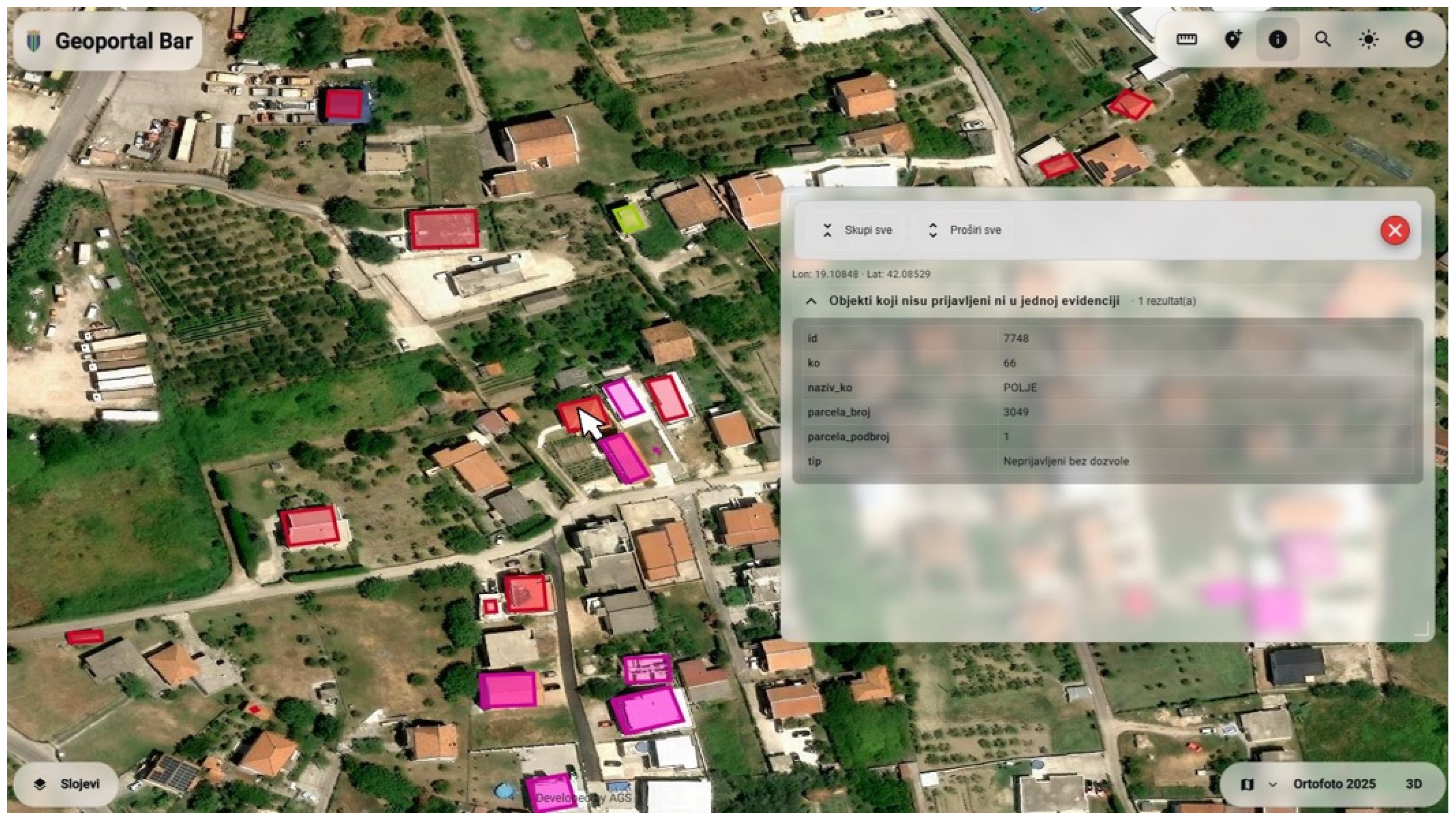
The data obtained from Phase 1 and Phase 2 of the spatial analysis were published through the Geoportal of the Municipality of Bar in order to support the visualization, management, and processing of detected candidate buildings without permits (Figure 10). The geoportal provides an overview of detected objects, categorized according to their legalization status and relationship with existing cadastral records, thereby enabling more efficient monitoring and management of legalization procedures.
The geoportal is directly connected to the Municipality of Bar central geospatial cadastral database, ensuring real-time access to data without intermediate data duplication. All spatial and attribute datasets are served directly from the authoritative cadastral database through standard OGC web services and REST APIs, ensuring data consistency and up-to-date information.
Access control is implemented through a role-based user management system, where different levels of permissions are assigned to system users (e.g., administrators, cadastral officers, and field inspection staff). This ensures secure data access and controlled editing rights depending on user responsibilities. In addition, a dedicated administrative module has been implemented for cadastral officers and field inspection personnel, enabling them to validate and verify information collected from the field. Verified data are then used as official input for updating cadastral records and supporting legalization procedures.
The system also supports defined administrative status transitions of detected buildings, enabling tracking from initial detection, through field verification, to final cadastral registration or legalization decision. This workflow ensures full traceability of each object throughout the administrative process.
The proposed system provides significant benefits for the municipality by creating a clear overview of the number, distribution, and categories of buildings without permits, including registered, unregistered reported and unreported, and potentially legal objects without corresponding geometry in the digital cadastral plan. Such information enables local authorities to better understand the extent of construction without permits within the municipality and to prioritize legalization activities and field inspections. In addition, the system supports more efficient property taxation by enabling the inclusion of previously unregistered buildings into official cadastral and tax records. Increased tax revenues generated through the registration and legalization of buildings can subsequently be invested in municipal infrastructure and public services, such as road reconstruction, water supply systems, sewage networks, public lighting, schools, green areas, and other urban development projects.
The geoportal also provides a dedicated interface for authorized users responsible for processing legalization cases and administrative procedures. Through this interface, users can manage and resolve cases according to predefined workflows and detected object categories. For verified buildings without permits, the procedure includes validation of the detected object, manual or automatic assignment of a building number, registration of the object in the real estate cadaster with an annotation indicating its status, and integration of its geometry into the digital cadastral plan. After registration, a notification containing further instructions is sent to the rights holder. If detected buildings are located on parcels for which legalization requests have already been submitted but no cadastral registration exists, additional verification is performed either through field inspection or by analyzing aerial imagery together with the parcel rights holder. Following verification, the object is assigned a building number and corresponding annotation that it is without permit, after which the rights holder is notified about the next steps in the legalization process. For objects belonging to the so-called “gray zone” category, field verification is mandatory. After confirmation, the building is assigned a number, registered in the cadaster with an appropriate legal annotation, and incorporated into the digital cadastral plan. The rights holder is then informed about the continuation of the legalization procedure and related obligations. In certain situations, detected objects may already be legally registered, but their geometry is missing from the digital cadastral plan. In such cases, the detected geometry is linked with the existing cadastral records in order to improve the completeness and consistency of cadastral data.
Overall, the proposed approach contributes to improving cadastral data quality, increasing transparency in legalization procedures, supporting more efficient administrative workflows, and strengthening spatial planning and land management processes within the municipality. Furthermore, the integration of detected objects into official cadastral and taxation systems creates long-term economic and administrative benefits for local government authorities and citizens alike.

4. Discussion

The results of this study demonstrate that the integration of deep learning techniques, geospatial analysis, and LADM-based cadastral modeling can significantly improve the identification and management of buildings constructed without permits. The proposed framework enables a systematic comparison between detected building footprints and official cadastral and legalization records, thereby supporting the identification of unreported and inconsistently registered buildings within the Municipality of Bar.
The performed experiments confirmed that semantic segmentation approaches, particularly DeepLabV3, provide an efficient solution for the large-scale detection of buildings from high-resolution orthophotos. The selected model achieved an optimal balance between computational efficiency and segmentation accuracy, making it suitable for operational implementation in municipal and cadastral workflows. The obtained results are especially important in coastal regions characterized by rapid and often uncontrolled tourism-related urbanization. In such environments, buildings without permits are frequently represented by scattered coastal villas and smaller detached structures with disjoint boundaries distributed across heterogeneous terrain. Semantic segmentation proved particularly suitable for these conditions because it efficiently detects dispersed built-up areas and complex roof geometries over large territories.
The identification and registration of buildings without permits also provide important economic and public safety benefits for municipalities. By detecting previously unregistered buildings and integrating them into official cadastral and taxation systems, municipalities can significantly increase property tax revenue and other administrative fees. These additional financial resources can subsequently be invested in public infrastructure and services, including roads, water supply systems, sewage networks, schools, healthcare facilities, public lighting, and green urban areas. At the same time, buildings without permits may represent serious safety hazards because they are often constructed without the necessary building permits, technical documentation, structural supervision, and mandatory safety inspections. As a result, such structures may not comply with engineering, environmental, seismic, or fire protection standards, posing risks to both residents and surrounding communities. Therefore, systematic detection and legalization of buildings without permits contribute not only to improved land administration and taxation, but also to increased public safety and more sustainable urban development.
The integration of detected buildings with cadastral parcels, legalization requests, and administrative records additionally demonstrated the importance of combining remote sensing analysis with land administration systems. The proposed LADM extension provides a structured mechanism for linking automatically detected objects with legalization procedures and cadastral registration processes. This contributes to improving cadastral completeness, transparency, and the traceability of administrative workflows.
Although the study achieved successful results in identifying candidate buildings without permits, there is room for further improvements, which will be addressed in future work.
One of the primary challenges relates to inconsistencies and outdated information in cadastral datasets. The building footprints were derived from the official digital cadastral plan, which represents the most comprehensive and authoritative building dataset available for the Municipality of Bar. However, some demolished or abandoned buildings still existed in the reference data used for training, introducing a certain level of label noise into the training data, causing occasional false positive detections in forested or overgrown areas. In addition, certain natural features such as exposed rocks were incorrectly classified as buildings because of spectral and geometric similarities with rooftops. These issues indicate that the quality and temporal consistency of training datasets remain critical factors influencing model reliability.
A quantitative assessment of label noise was not performed because an independent, fully validated reference dataset describing the current status of all buildings across the municipality is not available, and its creation would require extensive field surveys or complete manual interpretation of the orthophotos. Consequently, the reported segmentation performance should be interpreted in the context of these limitations. Nevertheless, the objective of the proposed framework is not to generate legally authoritative building footprints, but to identify candidate buildings requiring further cadastral and administrative verification. All detected buildings classified as unreported, reported without permits, or belonging to the “gray zone” were subsequently reviewed by authorized municipal personnel through the geoportal using orthophotos, cadastral records, and where necessary, field inspections before any cadastral or legal action is undertaken. This verification step substantially reduces the impact of occasional false detections resulting from imperfect training labels. Future research will focus on improving the quality of the reference data and investigating the influence of label uncertainty on model performance through a quantitative assessment of label noise.
Another limitation concerns the geometric precision of extracted building boundaries. Although DeepLabV3 achieved good segmentation performance, semantic segmentation methods may produce generalized or partially merged building polygons, particularly where adjacent buildings are closely spaced. This issue is especially visible in dense urban environments where accurate delineation of individual building footprints is required for cadastral purposes. While edge-smoothing and post-processing improved the quality of extracted geometries, additional refinement methods are still necessary to achieve cadastral-level precision.
Future research should therefore focus on improving boundary delineation and generating more precise building geometries suitable for direct cadastral integration. This may include the use of advanced polygon regularization techniques, edge-aware neural networks, or the integration of additional data sources such as LiDAR and multispectral imagery.
In addition, future studies should investigate the application of instance segmentation approaches such as Mask R-CNN for dense urban environments. Although computationally more demanding, Mask R-CNN demonstrated superior capability in separating adjacent buildings and producing more precise instance-level boundaries. Such characteristics make it particularly suitable for highly urbanized coastal settlements with compact residential structures and multi-building complexes. A hybrid framework combining semantic segmentation for large-scale screening and Mask R-CNN for detailed urban analysis could therefore provide an optimal balance between efficiency and geometric precision.
Although preliminary experiments were conducted with U-Net, DeepLabV3, and Mask R-CNN to assess their suitability for the proposed application, the primary objective of this research was not to perform a comprehensive benchmark of deep learning architectures. Instead, the focus was on developing and validating an integrated land administration workflow that combines automated building detection with cadastral records, LADM-based modeling, and administrative verification procedures. Therefore, the principal contribution of this work was the development of workflow supporting the cadastral and legalization procedure and demonstrating its operational applicability, rather than the standalone evaluation of semantic segmentation models. Consequently, DeepLabV3 was selected as the most appropriate model for operational implementation within the proposed framework. No explicit spatial block partitioning was performed, and an independent test set was not created. The ArcGIS Pro training workflow automatically reserved approximately 10% of the generated image chips for validation, while the remaining samples were used for training. Consequently, the reported performance metrics refer to the validation dataset. The inclusion of geographically independent training, validation, and test partitions, and an independent test set would provide a more rigorous assessment of model performance and generalization, and it is considered as an important direction for future research.
Future research will also include a systematic quantitative comparison of DeepLabV3, U-Net, and Mask R-CNN under identical experimental conditions, using standardized training, validation, and test datasets together with comprehensive semantic- and object-level evaluation metrics, to provide a rigorous assessment of their relative performance for cadastral applications. Systematic benchmarking using standardized datasets, spatially independent validation, and comprehensive evaluation metrics are important aspects of the thorough model evaluation. Therefore, a comprehensive quantitative assessment of the complete land administration workflow, including a confusion matrix for legal-status classification, large-scale field validation, and full benchmarking of alternative deep learning models, has not yet been performed. These aspects represent important directions for future research.
Buildings in the first category (unreported candidate buildings) are not recorded in any available cadastral or administrative dataset and therefore represent strong candidates for construction without permits. However, their final legal status can only be confirmed through the official administrative verification process. This verification is currently underway through the municipal geoportal, where authorized operators review detected objects using available imagery, cadastral records, and administrative case files, while ambiguous cases are verified through field inspections together with property owners. As this administrative process requires considerable time, broader independent validation will be completed as part of future work once the ongoing verification procedures have been finalized.
Broader empirical validation across additional municipalities in Montenegro was identified as an important direction for future work, in order to further confirm the transferability, robustness, and operational applicability of the proposed framework under different local spatial and cadastral conditions.
Another important direction for future work includes the development of automated validation procedures and the integration of field inspection data through mobile GIS applications and geoportal services. This would further improve administrative efficiency and support the near real-time monitoring and verification of candidate buildings without permits. Finally, the methodology should be tested in additional municipalities and different geographical conditions to evaluate its scalability, transferability, and robustness across broader cadastral and urban contexts.

5. Conclusions

This paper presented an integrated framework for identifying candidate buildings without permits through the combination of deep learning, geospatial analysis, and LADM-based cadastral modeling. The proposed methodology enables the automatic extraction of building footprints from high-resolution orthophoto imagery and their comparison with official cadastral records, legalization applications, and administrative datasets. The results demonstrated that DeepLabV3 semantic segmentation provides an efficient and reliable solution for the large-scale detection of candidate buildings without permits, particularly in coastal environments characterized by scattered tourist villas and disjoint building boundaries.
The research further showed that integrating deep learning-derived spatial data with cadastral and administrative systems can significantly improve the completeness, efficiency, and transparency of land administration data and processes. The proposed LADM extension and geoportal support more efficient legalization procedures, cadastral updating, and the administrative verification and management of detected objects within municipal workflows. The approach therefore provides practical support for municipalities in improving spatial planning, taxation, and the management of buildings without permits by enabling the inclusion of previously unregistered buildings into official cadastral systems.
Although the proposed approach achieved promising results, several limitations remain related to outdated cadastral data, false positive detections, and the geometric precision of extracted building boundaries. Future research should focus on improving boundary delineation and generating more precise building geometries. In dense urban environments, future studies should also investigate the application of instance segmentation methods, which can provide more accurate separation and delineation of adjacent buildings.

Author Contributions

Conceptualization, A.R. and D.S.; methodology, A.R. and D.S.; software, A.R., A.G. and D.S.; validation, M.G. and D.R.; formal analysis, D.S.; investigation, A.R.; resources, D.R. and A.G.; data curation, M.G.; writing—original draft preparation, A.R.; writing—review and editing, D.S.; visualization, D.S.; supervision, D.R.; project administration, M.G. and A.G.; funding acquisition, M.G. and A.G. All authors have read and agreed to the published version of the manuscript.

Funding

This research received no external funding.

Data Availability Statement

The original contributions presented in this study are included in the article. Further inquiries can be directed to the corresponding author.

Acknowledgments

This research was supported by the Ministry of Science, Technological Development and Innovation (Contract No. 451-03-34/2026-03/200156) and the Faculty of Technical Sciences, University of Novi Sad through the project “Scientific and Artistic Research Work of Researchers in Teaching and Associate Positions at the Faculty of Technical Sciences, University of Novi Sad 2026” (No. 01-3609/1).

Conflicts of Interest

The authors declare no conflicts of interest.

References

  1. Official Gazette. Official Gazette of Montenegro, the Law on Legalization of Illegal Buildings. 2025. Available online: https://sekretarijat-za-ppor.podgorica.me/wp-content/uploads/2026/01/Zakon-o-legalizaciji-bespravnih-objekata.pdf (accessed on 20 May 2026).
  2. ISO 19152-2:2025; Geographic Information—Land Administration Domain Model (LADM) Part 2: Land Registration. ISO/TC211: Geneva, Switzerland, 2025. Available online: https://www.iso.org/standard/81264.html (accessed on 20 May 2026).
  3. Radulović, A.; Sladić, D.; Govedarica, M.; Raičević, D. Using LADM and BIM for property and tourist taxation in the municipality of Bar, Montenegro. Land Use Policy 2023, 131, 106715. [Google Scholar] [CrossRef]
  4. Govedarica, M.; Radulović, A.; Sladić, D. Designing and implementing a LADM-based cadastral information system in Serbia, Montenegro and Republic of Srpska. Land Use Policy 2021, 109, 105732. [Google Scholar] [CrossRef]
  5. Ronneberger, O.; Fischer, P.; Brox, T. U-net: Convolutional networks for biomedical image segmentation. In Medical Image Computing and Computer-Assisted Intervention–MICCAI 2015: 18th International Conference, Munich, Germany, 5–9 October 2015; Springer: Cham, Switzerland, 2015; pp. 234–241. [Google Scholar]
  6. Chen, L.C.; Zhu, Y.; Papandreou, G.; Schroff, F.; Adam, H. Encoder-decoder with atrous separable convolution for semantic image segmentation. In Proceedings of the European Conference on Computer Vision; Springer: Cham, Switzerland, 2018; pp. 801–818. [Google Scholar]
  7. He, K.; Gkioxari, G.; Dollár, P.; Girshick, R. Mask R-CNN. In Proceedings of the IEEE International Conference on Computer Vision; IEEE: New York, NY, USA, 2017; pp. 2961–2969. [Google Scholar]
  8. Huang, X.; Zhang, Z.; Li, J. China’s first sub-meter building footprints derived by deep learning. Remote Sens. Environ. 2024, 311, 114274. [Google Scholar] [CrossRef]
  9. Saadati, D.; Hao, H. AttUNet+: Towards high-fidelity building footprints. Remote Sens. Appl. Soc. Environ. 2025, 39, 101715. [Google Scholar] [CrossRef]
  10. Qian, Z.; Chen, M.; Sun, Z.; Zhang, F.; Xu, Q.; Guo, J.; Xie, Z.; Zhang, Z. Simultaneous extraction of spatial and attributional building information across large-scale urban landscapes from high-resolution satellite imagery. Sustain. Cities Soc. 2024, 106, 105393. [Google Scholar]
  11. Yuan, Y.; Shi, X.; Gao, J. Building extraction from remote sensing images with deep learning: A survey on vision techniques. Comput. Vis. Image Underst. 2025, 251, 104253. [Google Scholar]
  12. Abdollahi, A.; Pradhan, B. Integrating semantic edges and segmentation information for building extraction from aerial images using UNet. Mach. Learn. Appl. 2021, 6, 100194. [Google Scholar] [CrossRef]
  13. Pasquali, G.; Iannelli, G.C.; Dell’Acqua, F. Building footprint extraction from multispectral, spaceborne earth observation datasets using a structurally optimized U-Net convolutional neural network. Remote Sens. 2019, 11, 2803. [Google Scholar] [CrossRef]
  14. Ni, H.; Wang, D.; Zhao, W.; Jiang, W.; Mingze, E.; Huang, C.; Yao, J. Enhancing rooftop solar energy potential evaluation in high-density cities: A deep learning and GIS based approach. Energy Build. 2024, 309, 113743. [Google Scholar] [CrossRef]
  15. Li, Z.; Zhang, S.; Dong, J. Suggestive data annotation for CNN-based building footprint mapping based on deep active learning and landscape metrics. Remote Sens. 2022, 14, 3147. [Google Scholar] [CrossRef]
  16. Li, Z.; Dong, J. A framework integrating DeeplabV3+, transfer learning, active learning, and incremental learning for mapping building footprints. Remote Sens. 2022, 14, 4738. [Google Scholar] [CrossRef]
  17. Zhang, L.; Wu, J.; Fan, Y.; Gao, H.; Shao, Y. An efficient building extraction method from high spatial resolution remote sensing images based on improved Mask R-CNN. Sensors 2020, 20, 1465. [Google Scholar] [CrossRef] [PubMed]
  18. Han, Q.; Yin, Q.; Zheng, X.; Chen, Z. Remote sensing image building detection method based on Mask R-CNN. Complex Intell. Syst. 2022, 8, 1847–1855. [Google Scholar]
  19. Wang, W.; Shi, Y.; Zhang, J.; Hu, L.; Li, S.; He, D.; Liu, F. Traditional village building extraction based on improved Mask R-CNN: A case study of Beijing, China. Remote Sens. 2023, 15, 2616. [Google Scholar] [CrossRef]
  20. Hou, T.; Li, J. Application of Mask R-CNN for building detection in UAV remote sensing images. Heliyon 2024, 10, e38141. [Google Scholar] [CrossRef] [PubMed]
  21. Hakim, Y.F.; Tsai, F. Building footprint extraction for large-scale basemaps using very-high-resolution satellite imagery. Buildings 2026, 16, 675. [Google Scholar] [CrossRef]
  22. Sakeena, M.; Stumpe, E.; Despotovic, M.; Koch, D.; Zeppelzauer, M. On the robustness and generalization ability of building footprint extraction on the example of SegNet and Mask R-CNN. Remote Sens. 2023, 15, 2135. [Google Scholar] [CrossRef]
  23. Mehta, Y.; Baz, A.; Patel, S.K. Semantic segmentation of optical satellite images for the illegal construction detection using transfer learning. Results Eng. 2024, 24, 103383. [Google Scholar] [CrossRef]
  24. Jiang, W.; Zhang, H.; Zheng, N.; Miao, Z. MTF-BFE: A multi-task learning framework for building footprint extraction by fusing historical cadastral maps with up-to-date remote sensing images. Inf. Fusion 2026, 135, 104458. [Google Scholar] [CrossRef]
  25. Jovanović, D.; Gavrilović, M.; Sladić, D.; Radulović, A.; Govedarica, M. Building change detection method to support register of identified changes on buildings. Remote Sens. 2021, 13, 3150. [Google Scholar] [CrossRef]
  26. Liu, W.; Li, Y.; Zhang, S.; Mao, R. Towards smart city supervision: A detection pipeline for illegal buildings. Eng. Appl. Artif. Intell. 2026, 163, 113052. [Google Scholar] [CrossRef]
  27. Romano, B.; Zullo, F.; Fiorini, L.; Marucci, A. Illegal building in Italy: Too complex a problem for national land policy? Cities 2021, 112, 103159. [Google Scholar] [CrossRef]
  28. Official Gazette. Official Gazette of Montenegro, the Law on State Survey and Cadastre. 2007. Available online: https://www.gov.me/en/documents/f30d49bf-74c1-44b4-9b6a-dcf7d16301dc (accessed on 20 May 2026).
  29. Kalogianni, E.; Janečka, K.; Kalantari, M.; Dimopoulou, E.; Bydłosz, J.; Radulović, A.; Vučić, N.; Sladić, D.; Govedarica, M.; Lemmen, C.; et al. Methodology for the development of LADM country profiles. Land Use Policy 2021, 105, 105380. [Google Scholar] [CrossRef]
  30. Official Gazette. Official Gazette of Montenegro, the Law on Spatial Planning and Building Construction. 2017. Available online: https://www.paragraf.me/propisi-crnegore/zakon-o-planiranju-prostora-i-izgradnji-objekata.html (accessed on 20 May 2026).
  31. Geoportal of the Municipality of Bar. Available online: https://geoportal.bar.me/ (accessed on 20 May 2026).
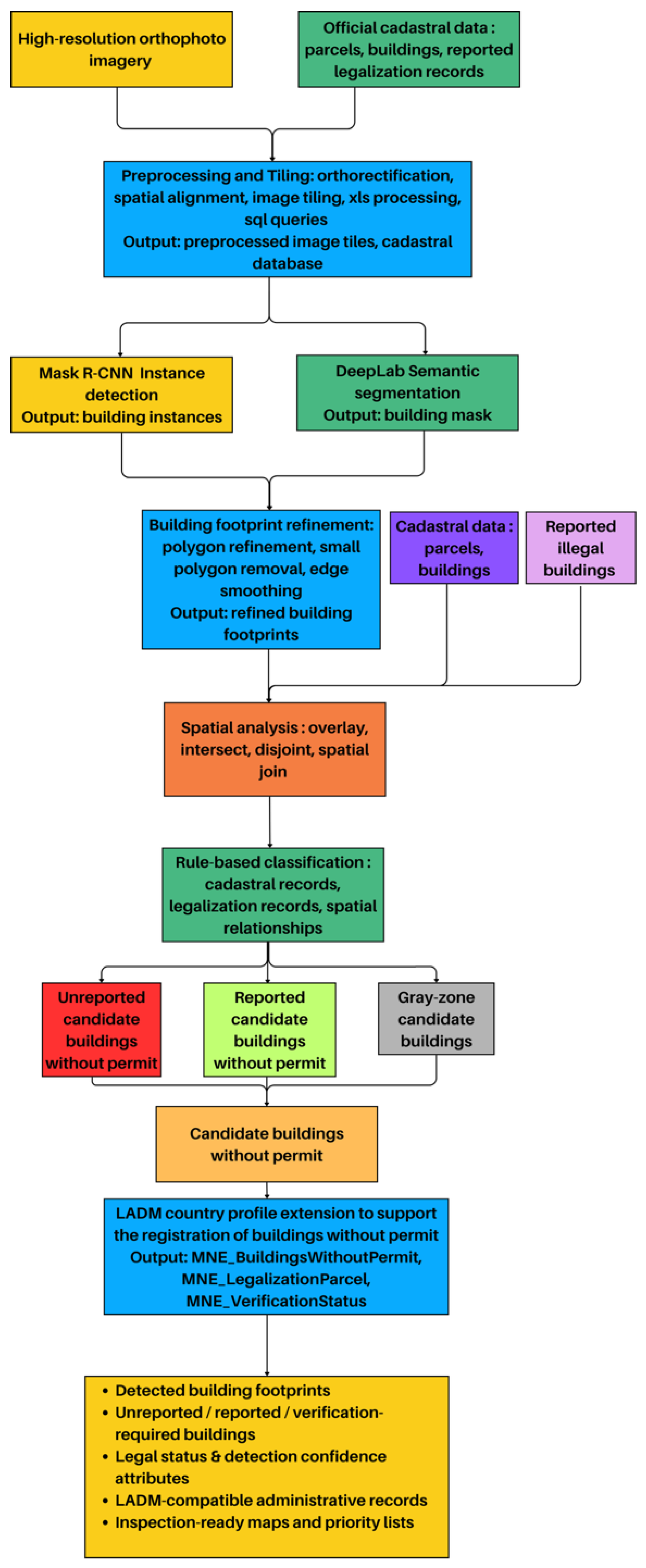
Figure 1. Methodology framework.
Land 15 01276 g001
Figure 2. Example of an Excel-based register of the reported buildings without permits, showing a case with incomplete applicant-provided cadastral information.
Land 15 01276 g002
Figure 3. Orthophoto of the Municipality of Bar.
Land 15 01276 g003
Figure 4. Semantic segmentation using DeepLabV3 model: (a) detected buildings; (b) detected buildings in vector format (zoomed view).
Land 15 01276 g004
Figure 5. Loss function per (a) epochs; (b) batches processed.
Land 15 01276 g005
Figure 6. Spatial analysis of building data through two phases.
Land 15 01276 g006
Figure 7. Spatial distribution of the density indicator across cadastral municipalities in the Municipality of Bar.
Land 15 01276 g007
Figure 8. Selected core classes from the Montenegrin LADM-based country profile (adapted from [4]).
Land 15 01276 g008
Figure 9. Extended LADM-based country profile for supporting the legalization process of buildings constructed without permits.
Land 15 01276 g009
Figure 10. Geoportal of the Municipality of Bar displaying the three categories of detected buildings without permits and the attributes of the selected building [31].
Land 15 01276 g010
Table 1. Terminology used in this manuscript for detected and verified building objects.
LevelTerm Used in ManuscriptDefinitionStage of Determination
1Automatically detected candidate objectsBuildings detected from orthophoto imagery using deep learning models. They represent all structures identified as potential buildings regardless of legal status.AI-based detection (pre-verification)
2aUnreported candidate buildings without permitsDetected buildings that are not present in cadastral records, legalization applications, or other administrative datasets.AI + spatial overlay analysis
2bReported candidate buildings without permitsDetected buildings that correspond to existing legalization applications or records of construction without permits.AI + administrative record matching
2cGray-zone candidate buildingsDetected buildings with inconsistent or incomplete matching across cadastral and administrative datasets (e.g., merged objects, missing geometry, or ambiguous parcel linkage).AI + spatial ambiguity detection
3Administratively confirmed objectsBuildings whose legal status is verified through cadastral update procedures, geoportal validation, and/or field inspection by authorized operators.Post-verification (official status)
Table 2. Preliminary conceptual comparison of candidate deep learning architectures used for model selection for building detection in orthophoto imagery.
MethodDetection AccuracySegmentation QualityComputational EfficiencyAdvantagesLimitations
U-NetModerateGood semantic segmentationHighSimple architecture, fast training and inference, suitable for limited datasetsLower robustness in complex urban environments; may struggle with heterogeneous building patterns
DeepLabHighHighHighBest balance between accuracy and processing speed; effective in capturing multi-scale contextual information; efficient inferenceDoes not provide instance-level segmentation of individual buildings
Mask R-CNNVery HighVery High (instance-level)LowPrecise detection and delineation of individual buildings; distinguishes overlapping objectsRequires significantly higher computational resources and longer processing times
Table 3. Statistics of the number of buildings by cadastral municipalities.
Cadastral Municipality Area of Cadastral Municipality (km2)No. of Buildings in Real Estate Cadaster DatabaseNo. of Buildings on Digital Cadastral PlanNo. of Applications for LegalizationNo. of Unreported Buildings Without PermitsNo. of Reported Buildings Without PermitsNo. of Probably Unreported Buildings Without PermitsDensity Indicator
Arbneš8.23276299162007.5
Bartula2.832452537910223746.7
Bobovište7.66156171068008.8
Boljevići8.521782304117629024.1
Braćeni10.21517021411015.1
Brčeli10.97146376683207.8
Brijege1.7454641190010.9
Bukovik6.6516519412965215.5
Ckla4.7797111646109.9
Dabezići9.30164231131077012.3
Dedići11.232530020001.8
Dobra Voda11.08140613616374021323451.2
Donji Murići7.3319320011707010.5
Dupilo9.5497203777408.5
Gluhi Do20.454625652920512110.7
Godinje4.921511718775517.7
Gurza9.1733360120183.3
Komarno10.3998140039003.8
Koštanjica12.05216254131102.7
Krnjice19.224874838592804.5
Kunje13.75211519999502471712732.4
Limljani19.12240408221641129.3
Livari20.47183204346702.6
Mala Gorana5.03112920540010.7
Martići15.304104460105006.9
Mikulići19.76144154145012.3
Mišići15.08186816669473892794447.2
Novi Bar6.8643914202155251525850120.0
Orahovo1.90801123561130.6
Ostros8.93260285066007.4
Ovtočići4.76512337927121.0
Pečurice8.732206218210193511212456.8
Pelinkovići6.121241327764013.1
Pinčići11.969164025002.1
Polje5.072594256967938213133107.8
Popratinice4.313271017003.9
Seoca14.6129634411541635.0
Sotonići6.87259263211077317.0
Sozina11.289294016001.4
Stari Bar4.27127312463182271141583.4
Sutomore2.71286415684122304398.2
Šušanj7.3016532717144422127770.0
Tejani11.387711508000.7
Tomba1.618748422192075517172.8
Tomići4.73110138432507.8
Trnovo4.303254314103.5
Tudjemili10.351261382588619.2
Turčini4.141739112504.1
Utrg13.4980339271315.6
Velja Gorana13.7724024921585212.0
Velje Selo9.401461872011611013.5
Virpazar1.431169930374129.5
Zaljevo7.5391084219722358838.4
Zankovići11.633271319310532221252532.0
Zupci11.0062553019822835424.3
Disclaimer/Publisher’s Note: The statements, opinions and data contained in all publications are solely those of the individual author(s) and contributor(s) and not of MDPI and/or the editor(s). MDPI and/or the editor(s) disclaim responsibility for any injury to people or property resulting from any ideas, methods, instructions or products referred to in the content.