Identifying Buildings Without Permits in Coastal Montenegro Using Deep Learning and Land Administration Modeling

 ,
,  ,
,  ,
,
Abstract
1. Introduction
- An integrated operational framework combining deep learning, spatial analysis, cadastral data and administrative records for identifying candidate buildings without permits.
- A rule-based methodology for classifying detected buildings into unreported buildings, reported buildings without permits, and gray-zone buildings requiring administrative verification.
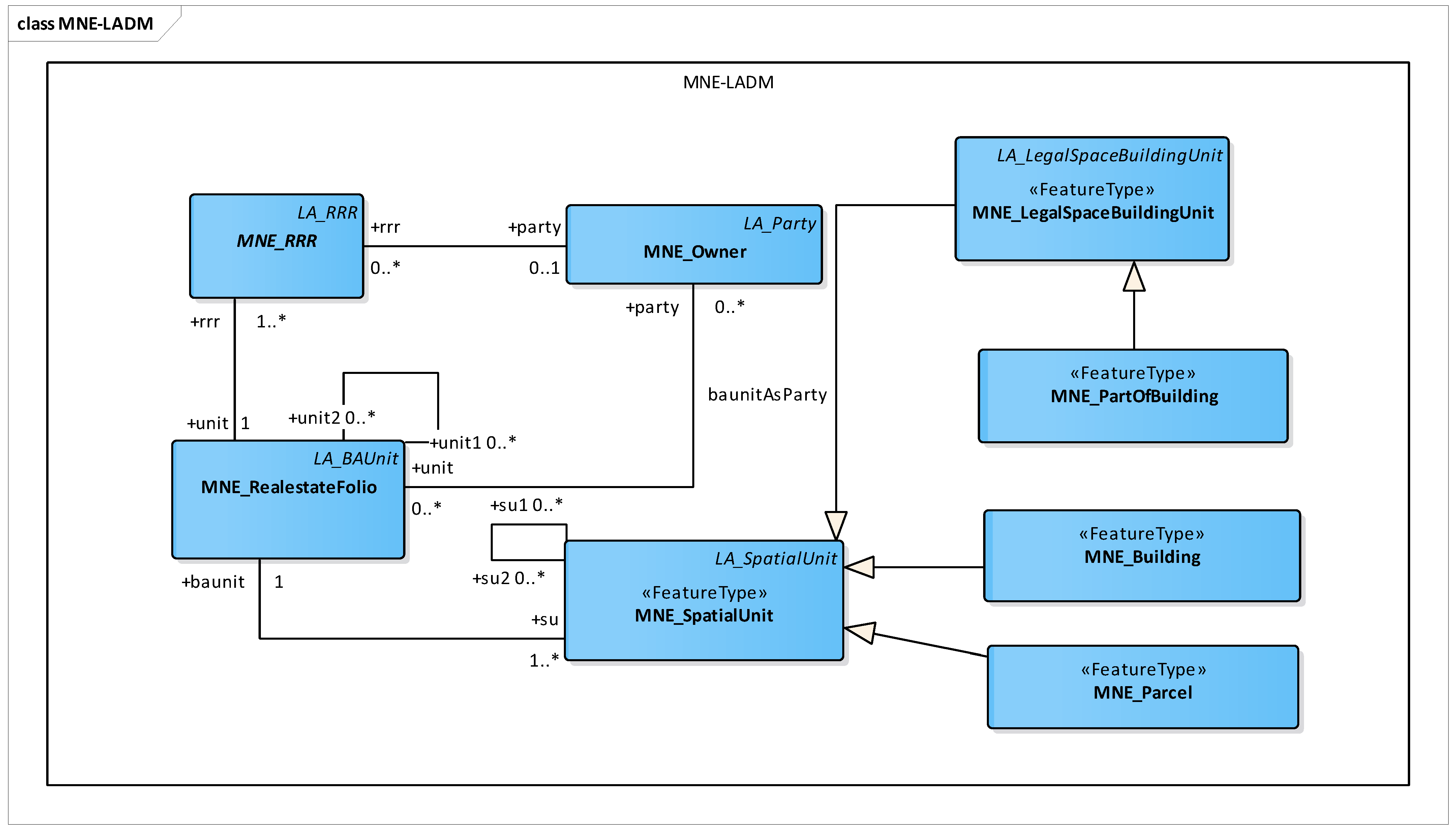
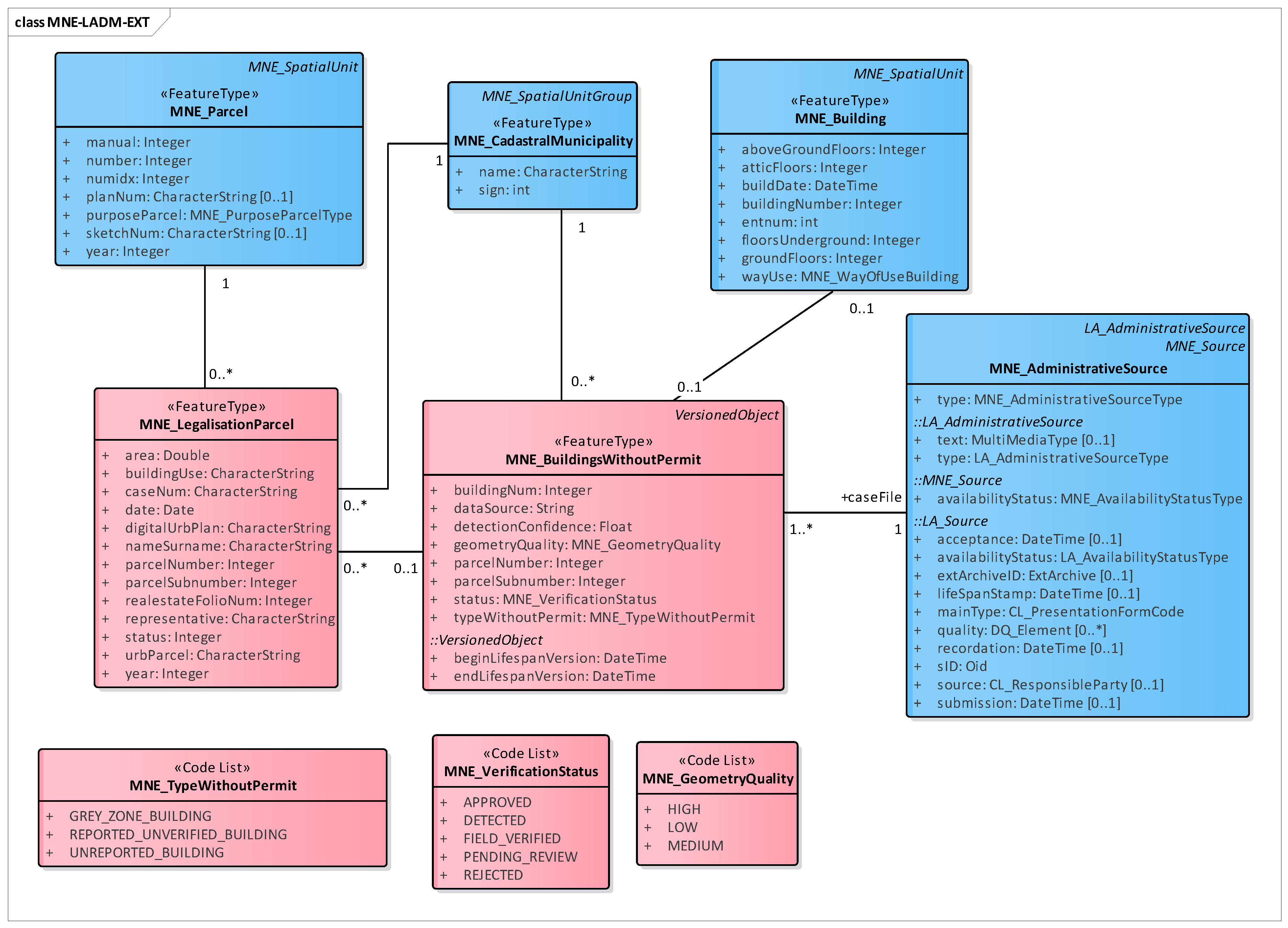
- An extension of the Montenegrin LADM country profile supporting the management of automatically detected buildings and legalization procedures.
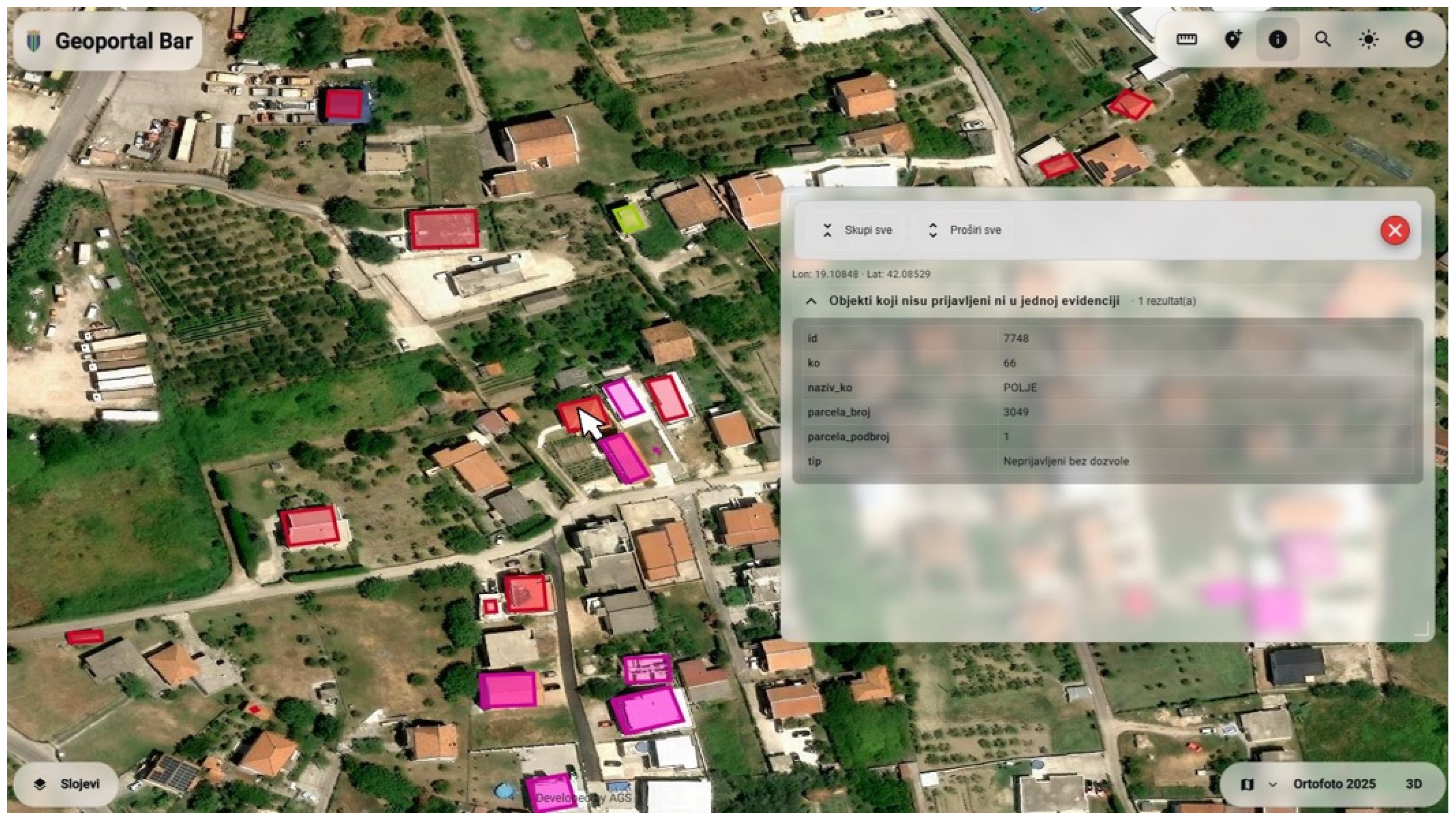
- A geoportal-based administrative workflow enabling the visualization, verification, and integration of detected buildings into cadastral processes.
- A real-world implementation and validation of the proposed framework using the Municipality of Bar, demonstrating its applicability for municipal land administration.
2. Materials and Methods
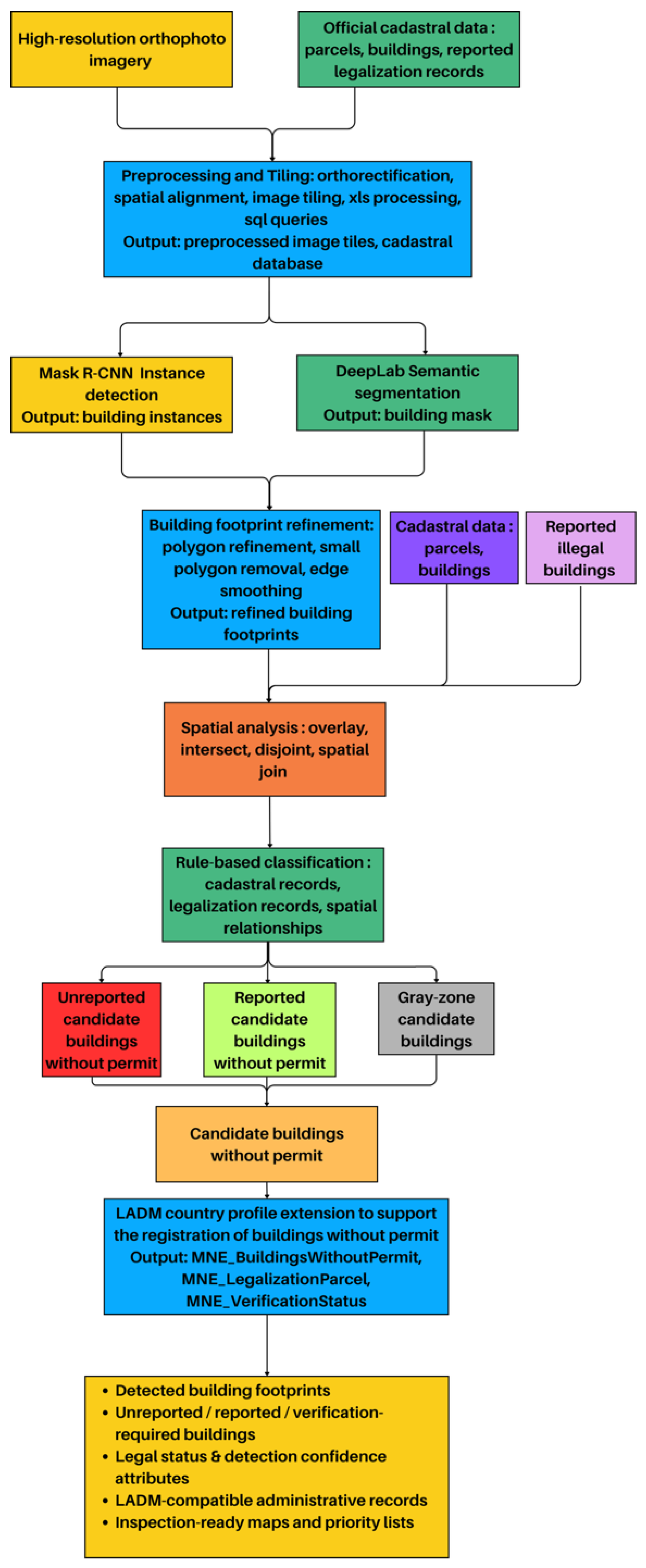
2.1. Methodological Framework
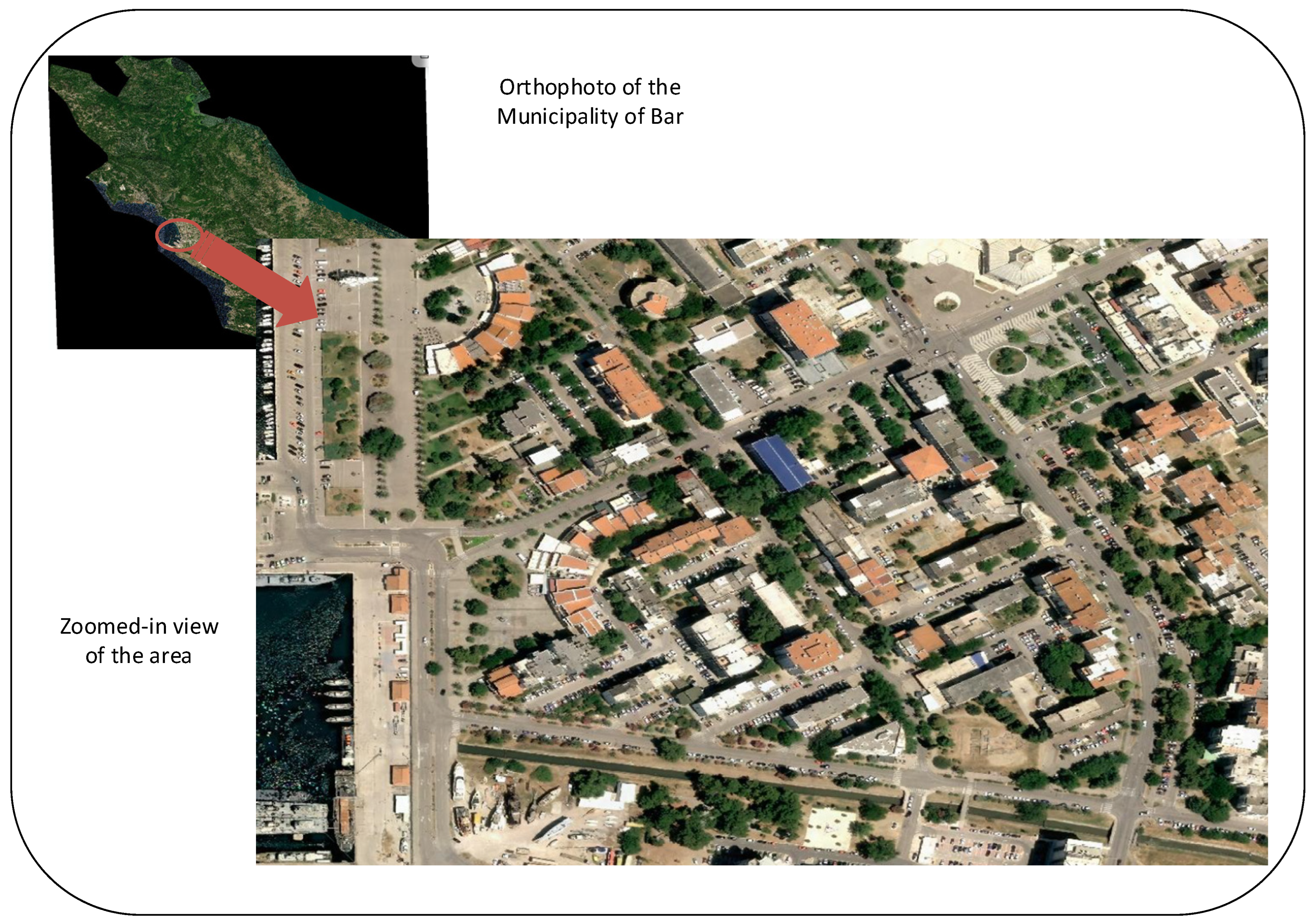
- Both orthophoto and official cadastral datasets undergo preprocessing and tiling to ensure spatial alignment, consistent resolution, and suitability for deep learning inference. Two deep learning approaches can be applied in parallel or separately: Mask R-CNN, for instance, level building detection and DeepLab for semantic segmentation. Using a dual approach enables both the precise delineation of individual building instances and robust extraction of built-up area, especially in dense urban areas.
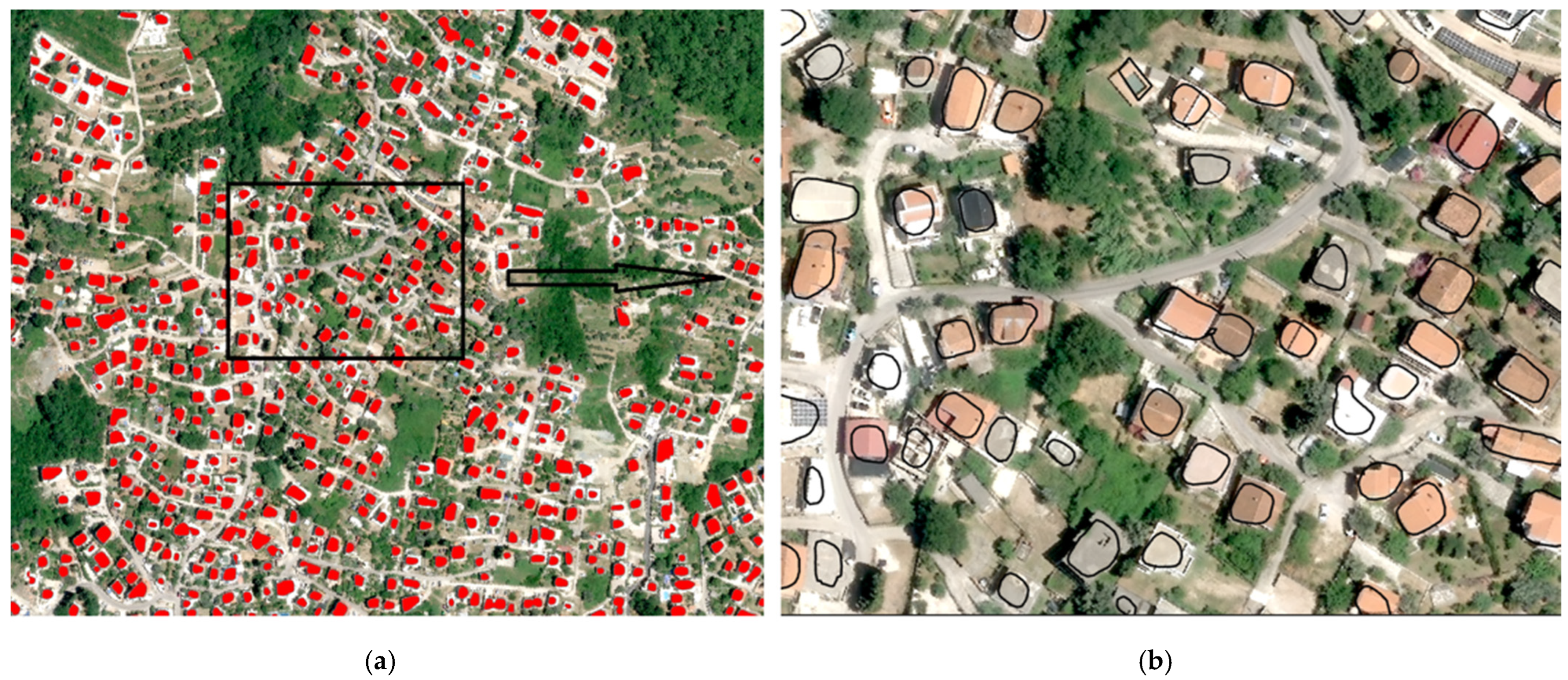
- The outputs of the previous step are refined through a building footprint refinement process, improving geometric accuracy and reducing segmentation noise. The refined building footprints are subsequently integrated with cadastral data and records of reported buildings without permits to support spatial comparison and attribution.
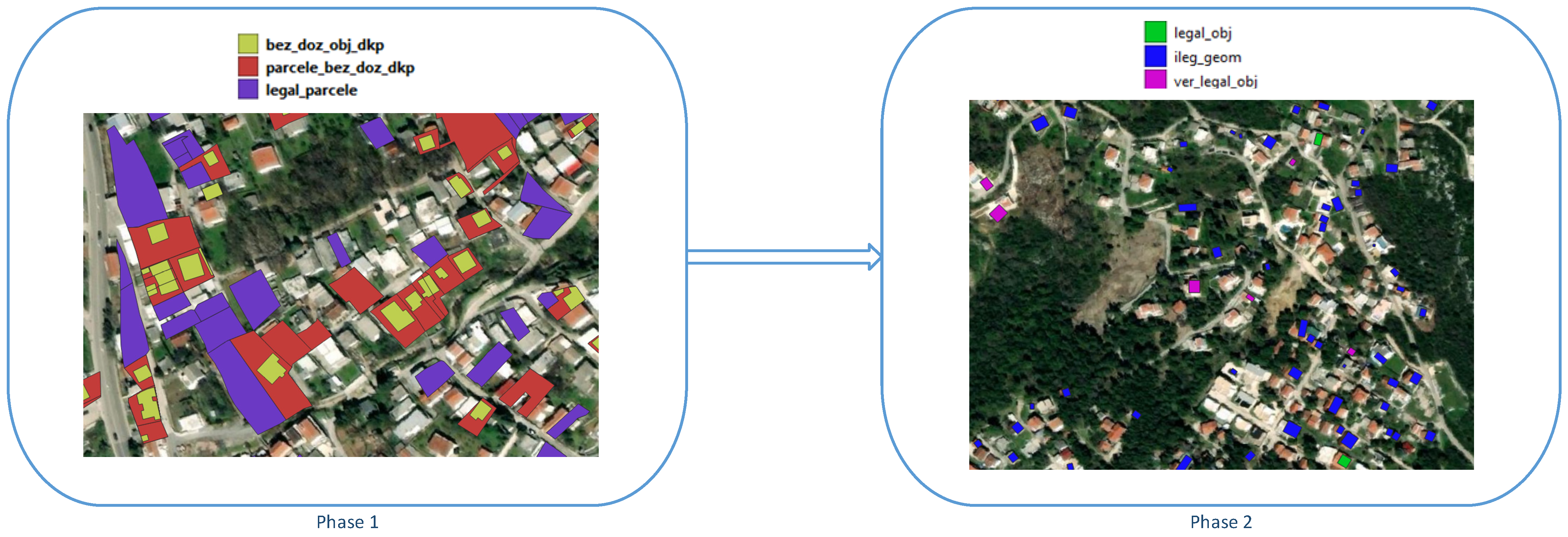
- A spatial analysis step evaluates topological and spatial relationships between detected buildings, cadastral parcels, registered structures, and reported constructions without permits. Based on this analysis, a rule-based classification is applied to categorize buildings into three groups: unreported candidate buildings without permits, reported candidate buildings without permits, and gray-zone buildings requiring further verification due to incomplete or ambiguous data.
- These categories are consolidated into a final class of buildings without permits, which serves as the basis for extending the national land administration domain model (LADM) country profile. The proposed extension supports the systematic registration and management of buildings constructed without permits.
- The framework produces multiple operational outputs, including detected building footprints, legal status indicators, detection confidence attributes, LADM-compatible administrative records, and inspection-ready maps with priority lists. Together, these outputs provide a scalable, data-driven foundation for supporting land administration, enforcement, and regularization processes.
2.2. Related Work
2.2.1. Building Footprint Extraction from High-Resolution Imagery
2.2.2. Semantic Segmentation Approaches
2.2.3. Instance Segmentation Approaches
2.2.4. Detection of Buildings Without Permits
2.2.5. Research Gap and Contribution
2.3. Cadastral Data and Related Laws in Montenegro
3. Results
3.1. Geospatial and Data-Driven Framework for Identification of Candidate Buildings Without Permits in Montenegro
3.1.1. Deep Learning-Based Detection of Building Footprints
3.1.2. Spatial Analysis and Cadastral Assessment of Candidate Buildings Without Permits
- For each detected building polygon B
- ST_Intersects (B, DCP_Buildings)YES → building already represented in DCPNO → continue
- ST_Intersects(B, Parcels_with_registered_buildings_without_permits)YES → Reported candidate buildingNO → continue
- ST_Intersects(B, Parcels_with_legalization_applications)YES → Reported candidate buildingNO → continue
- ST_Disjoint(B, all previous datasets)YES → Unreported candidate building
- Partial overlap, inconsistent parcel assignment, merged polygons, or missing DCP geometry→ Gray-zone candidate building.
3.2. LADM Country Profile Extension to Support the Registration of Buildings Constructed Without Permits
3.3. Geoportal for Administrative Verification and Integration of Field Inspection Results
4. Discussion
5. Conclusions
Author Contributions
Funding
Data Availability Statement
Acknowledgments
Conflicts of Interest
References
- Official Gazette. Official Gazette of Montenegro, the Law on Legalization of Illegal Buildings. 2025. Available online: https://sekretarijat-za-ppor.podgorica.me/wp-content/uploads/2026/01/Zakon-o-legalizaciji-bespravnih-objekata.pdf (accessed on 20 May 2026).
- ISO 19152-2:2025; Geographic Information—Land Administration Domain Model (LADM) Part 2: Land Registration. ISO/TC211: Geneva, Switzerland, 2025. Available online: https://www.iso.org/standard/81264.html (accessed on 20 May 2026).
- Radulović, A.; Sladić, D.; Govedarica, M.; Raičević, D. Using LADM and BIM for property and tourist taxation in the municipality of Bar, Montenegro. Land Use Policy 2023, 131, 106715. [Google Scholar] [CrossRef]
- Govedarica, M.; Radulović, A.; Sladić, D. Designing and implementing a LADM-based cadastral information system in Serbia, Montenegro and Republic of Srpska. Land Use Policy 2021, 109, 105732. [Google Scholar] [CrossRef]
- Ronneberger, O.; Fischer, P.; Brox, T. U-net: Convolutional networks for biomedical image segmentation. In Medical Image Computing and Computer-Assisted Intervention–MICCAI 2015: 18th International Conference, Munich, Germany, 5–9 October 2015; Springer: Cham, Switzerland, 2015; pp. 234–241. [Google Scholar]
- Chen, L.C.; Zhu, Y.; Papandreou, G.; Schroff, F.; Adam, H. Encoder-decoder with atrous separable convolution for semantic image segmentation. In Proceedings of the European Conference on Computer Vision; Springer: Cham, Switzerland, 2018; pp. 801–818. [Google Scholar]
- He, K.; Gkioxari, G.; Dollár, P.; Girshick, R. Mask R-CNN. In Proceedings of the IEEE International Conference on Computer Vision; IEEE: New York, NY, USA, 2017; pp. 2961–2969. [Google Scholar]
- Huang, X.; Zhang, Z.; Li, J. China’s first sub-meter building footprints derived by deep learning. Remote Sens. Environ. 2024, 311, 114274. [Google Scholar] [CrossRef]
- Saadati, D.; Hao, H. AttUNet+: Towards high-fidelity building footprints. Remote Sens. Appl. Soc. Environ. 2025, 39, 101715. [Google Scholar] [CrossRef]
- Qian, Z.; Chen, M.; Sun, Z.; Zhang, F.; Xu, Q.; Guo, J.; Xie, Z.; Zhang, Z. Simultaneous extraction of spatial and attributional building information across large-scale urban landscapes from high-resolution satellite imagery. Sustain. Cities Soc. 2024, 106, 105393. [Google Scholar]
- Yuan, Y.; Shi, X.; Gao, J. Building extraction from remote sensing images with deep learning: A survey on vision techniques. Comput. Vis. Image Underst. 2025, 251, 104253. [Google Scholar]
- Abdollahi, A.; Pradhan, B. Integrating semantic edges and segmentation information for building extraction from aerial images using UNet. Mach. Learn. Appl. 2021, 6, 100194. [Google Scholar] [CrossRef]
- Pasquali, G.; Iannelli, G.C.; Dell’Acqua, F. Building footprint extraction from multispectral, spaceborne earth observation datasets using a structurally optimized U-Net convolutional neural network. Remote Sens. 2019, 11, 2803. [Google Scholar] [CrossRef]
- Ni, H.; Wang, D.; Zhao, W.; Jiang, W.; Mingze, E.; Huang, C.; Yao, J. Enhancing rooftop solar energy potential evaluation in high-density cities: A deep learning and GIS based approach. Energy Build. 2024, 309, 113743. [Google Scholar] [CrossRef]
- Li, Z.; Zhang, S.; Dong, J. Suggestive data annotation for CNN-based building footprint mapping based on deep active learning and landscape metrics. Remote Sens. 2022, 14, 3147. [Google Scholar] [CrossRef]
- Li, Z.; Dong, J. A framework integrating DeeplabV3+, transfer learning, active learning, and incremental learning for mapping building footprints. Remote Sens. 2022, 14, 4738. [Google Scholar] [CrossRef]
- Zhang, L.; Wu, J.; Fan, Y.; Gao, H.; Shao, Y. An efficient building extraction method from high spatial resolution remote sensing images based on improved Mask R-CNN. Sensors 2020, 20, 1465. [Google Scholar] [CrossRef] [PubMed]
- Han, Q.; Yin, Q.; Zheng, X.; Chen, Z. Remote sensing image building detection method based on Mask R-CNN. Complex Intell. Syst. 2022, 8, 1847–1855. [Google Scholar]
- Wang, W.; Shi, Y.; Zhang, J.; Hu, L.; Li, S.; He, D.; Liu, F. Traditional village building extraction based on improved Mask R-CNN: A case study of Beijing, China. Remote Sens. 2023, 15, 2616. [Google Scholar] [CrossRef]
- Hou, T.; Li, J. Application of Mask R-CNN for building detection in UAV remote sensing images. Heliyon 2024, 10, e38141. [Google Scholar] [CrossRef] [PubMed]
- Hakim, Y.F.; Tsai, F. Building footprint extraction for large-scale basemaps using very-high-resolution satellite imagery. Buildings 2026, 16, 675. [Google Scholar] [CrossRef]
- Sakeena, M.; Stumpe, E.; Despotovic, M.; Koch, D.; Zeppelzauer, M. On the robustness and generalization ability of building footprint extraction on the example of SegNet and Mask R-CNN. Remote Sens. 2023, 15, 2135. [Google Scholar] [CrossRef]
- Mehta, Y.; Baz, A.; Patel, S.K. Semantic segmentation of optical satellite images for the illegal construction detection using transfer learning. Results Eng. 2024, 24, 103383. [Google Scholar] [CrossRef]
- Jiang, W.; Zhang, H.; Zheng, N.; Miao, Z. MTF-BFE: A multi-task learning framework for building footprint extraction by fusing historical cadastral maps with up-to-date remote sensing images. Inf. Fusion 2026, 135, 104458. [Google Scholar] [CrossRef]
- Jovanović, D.; Gavrilović, M.; Sladić, D.; Radulović, A.; Govedarica, M. Building change detection method to support register of identified changes on buildings. Remote Sens. 2021, 13, 3150. [Google Scholar] [CrossRef]
- Liu, W.; Li, Y.; Zhang, S.; Mao, R. Towards smart city supervision: A detection pipeline for illegal buildings. Eng. Appl. Artif. Intell. 2026, 163, 113052. [Google Scholar] [CrossRef]
- Romano, B.; Zullo, F.; Fiorini, L.; Marucci, A. Illegal building in Italy: Too complex a problem for national land policy? Cities 2021, 112, 103159. [Google Scholar] [CrossRef]
- Official Gazette. Official Gazette of Montenegro, the Law on State Survey and Cadastre. 2007. Available online: https://www.gov.me/en/documents/f30d49bf-74c1-44b4-9b6a-dcf7d16301dc (accessed on 20 May 2026).
- Kalogianni, E.; Janečka, K.; Kalantari, M.; Dimopoulou, E.; Bydłosz, J.; Radulović, A.; Vučić, N.; Sladić, D.; Govedarica, M.; Lemmen, C.; et al. Methodology for the development of LADM country profiles. Land Use Policy 2021, 105, 105380. [Google Scholar] [CrossRef]
- Official Gazette. Official Gazette of Montenegro, the Law on Spatial Planning and Building Construction. 2017. Available online: https://www.paragraf.me/propisi-crnegore/zakon-o-planiranju-prostora-i-izgradnji-objekata.html (accessed on 20 May 2026).
- Geoportal of the Municipality of Bar. Available online: https://geoportal.bar.me/ (accessed on 20 May 2026).





| Level | Term Used in Manuscript | Definition | Stage of Determination |
|---|---|---|---|
| 1 | Automatically detected candidate objects | Buildings detected from orthophoto imagery using deep learning models. They represent all structures identified as potential buildings regardless of legal status. | AI-based detection (pre-verification) |
| 2a | Unreported candidate buildings without permits | Detected buildings that are not present in cadastral records, legalization applications, or other administrative datasets. | AI + spatial overlay analysis |
| 2b | Reported candidate buildings without permits | Detected buildings that correspond to existing legalization applications or records of construction without permits. | AI + administrative record matching |
| 2c | Gray-zone candidate buildings | Detected buildings with inconsistent or incomplete matching across cadastral and administrative datasets (e.g., merged objects, missing geometry, or ambiguous parcel linkage). | AI + spatial ambiguity detection |
| 3 | Administratively confirmed objects | Buildings whose legal status is verified through cadastral update procedures, geoportal validation, and/or field inspection by authorized operators. | Post-verification (official status) |
| Method | Detection Accuracy | Segmentation Quality | Computational Efficiency | Advantages | Limitations |
|---|---|---|---|---|---|
| U-Net | Moderate | Good semantic segmentation | High | Simple architecture, fast training and inference, suitable for limited datasets | Lower robustness in complex urban environments; may struggle with heterogeneous building patterns |
| DeepLab | High | High | High | Best balance between accuracy and processing speed; effective in capturing multi-scale contextual information; efficient inference | Does not provide instance-level segmentation of individual buildings |
| Mask R-CNN | Very High | Very High (instance-level) | Low | Precise detection and delineation of individual buildings; distinguishes overlapping objects | Requires significantly higher computational resources and longer processing times |
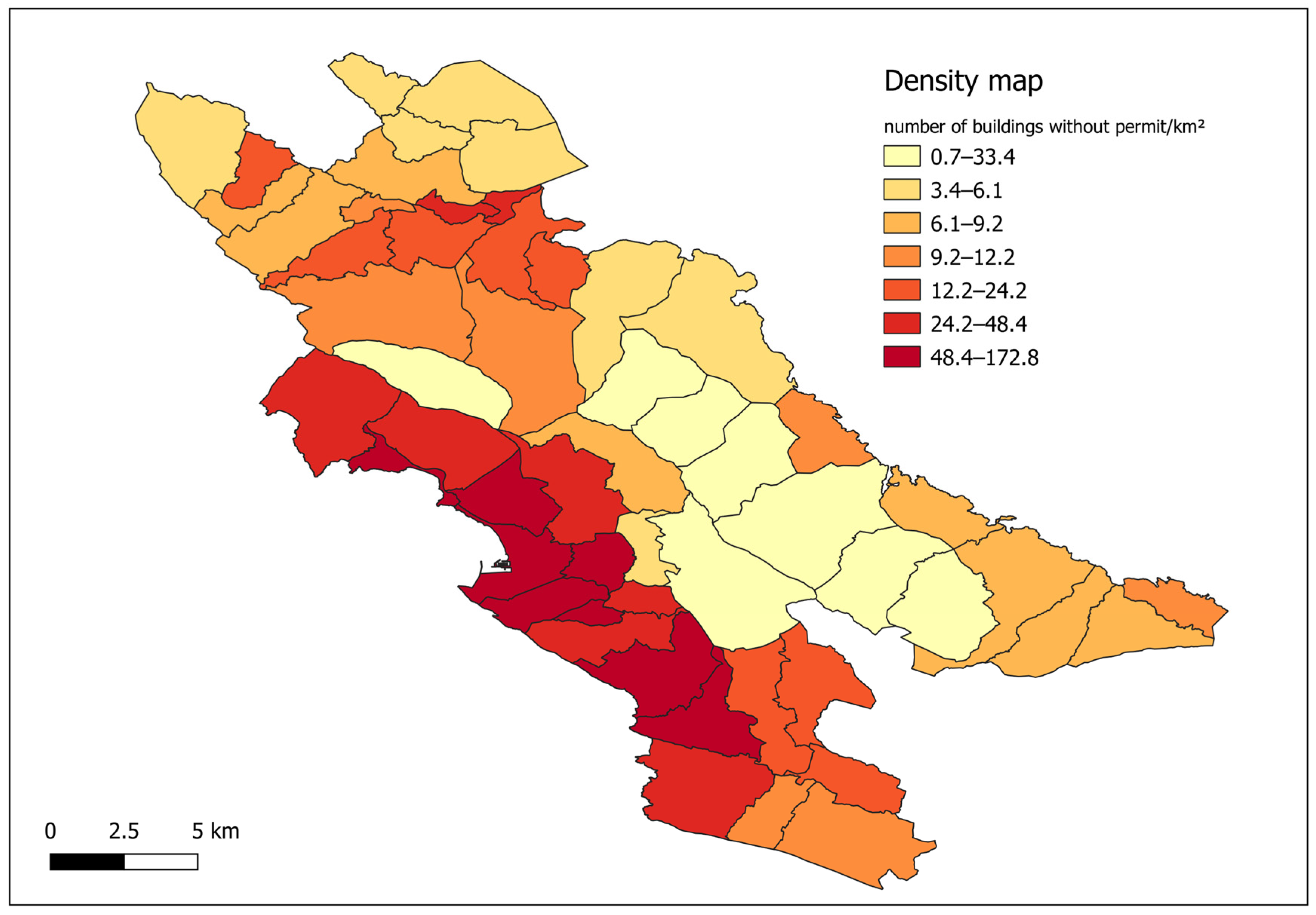
| Cadastral Municipality | Area of Cadastral Municipality (km2) | No. of Buildings in Real Estate Cadaster Database | No. of Buildings on Digital Cadastral Plan | No. of Applications for Legalization | No. of Unreported Buildings Without Permits | No. of Reported Buildings Without Permits | No. of Probably Unreported Buildings Without Permits | Density Indicator |
|---|---|---|---|---|---|---|---|---|
| Arbneš | 8.23 | 276 | 299 | 1 | 62 | 0 | 0 | 7.5 |
| Bartula | 2.83 | 245 | 253 | 79 | 102 | 23 | 7 | 46.7 |
| Bobovište | 7.66 | 156 | 171 | 0 | 68 | 0 | 0 | 8.8 |
| Boljevići | 8.52 | 178 | 230 | 41 | 176 | 29 | 0 | 24.1 |
| Braćeni | 10.21 | 51 | 70 | 21 | 41 | 10 | 1 | 5.1 |
| Brčeli | 10.97 | 146 | 376 | 6 | 83 | 2 | 0 | 7.8 |
| Brijege | 1.74 | 54 | 64 | 1 | 19 | 0 | 0 | 10.9 |
| Bukovik | 6.65 | 165 | 194 | 12 | 96 | 5 | 2 | 15.5 |
| Ckla | 4.77 | 97 | 111 | 6 | 46 | 1 | 0 | 9.9 |
| Dabezići | 9.30 | 164 | 231 | 13 | 107 | 7 | 0 | 12.3 |
| Dedići | 11.23 | 25 | 30 | 0 | 20 | 0 | 0 | 1.8 |
| Dobra Voda | 11.08 | 1406 | 1361 | 637 | 402 | 132 | 34 | 51.2 |
| Donji Murići | 7.33 | 193 | 200 | 11 | 70 | 7 | 0 | 10.5 |
| Dupilo | 9.54 | 97 | 203 | 7 | 77 | 4 | 0 | 8.5 |
| Gluhi Do | 20.45 | 462 | 565 | 29 | 205 | 12 | 1 | 10.7 |
| Godinje | 4.92 | 151 | 171 | 8 | 77 | 5 | 5 | 17.7 |
| Gurza | 9.17 | 33 | 36 | 0 | 12 | 0 | 18 | 3.3 |
| Komarno | 10.39 | 98 | 140 | 0 | 39 | 0 | 0 | 3.8 |
| Koštanjica | 12.05 | 216 | 254 | 1 | 31 | 1 | 0 | 2.7 |
| Krnjice | 19.22 | 487 | 483 | 8 | 59 | 28 | 0 | 4.5 |
| Kunje | 13.75 | 2115 | 1999 | 950 | 247 | 171 | 27 | 32.4 |
| Limljani | 19.12 | 240 | 408 | 22 | 164 | 11 | 2 | 9.3 |
| Livari | 20.47 | 183 | 204 | 3 | 46 | 7 | 0 | 2.6 |
| Mala Gorana | 5.03 | 112 | 92 | 0 | 54 | 0 | 0 | 10.7 |
| Martići | 15.30 | 410 | 446 | 0 | 105 | 0 | 0 | 6.9 |
| Mikulići | 19.76 | 144 | 154 | 1 | 45 | 0 | 1 | 2.3 |
| Mišići | 15.08 | 1868 | 1666 | 947 | 389 | 279 | 44 | 47.2 |
| Novi Bar | 6.86 | 4391 | 4202 | 1552 | 515 | 258 | 50 | 120.0 |
| Orahovo | 1.90 | 80 | 112 | 3 | 56 | 1 | 1 | 30.6 |
| Ostros | 8.93 | 260 | 285 | 0 | 66 | 0 | 0 | 7.4 |
| Ovtočići | 4.76 | 51 | 233 | 7 | 92 | 7 | 1 | 21.0 |
| Pečurice | 8.73 | 2206 | 2182 | 1019 | 351 | 121 | 24 | 56.8 |
| Pelinkovići | 6.12 | 124 | 132 | 7 | 76 | 4 | 0 | 13.1 |
| Pinčići | 11.96 | 91 | 64 | 0 | 25 | 0 | 0 | 2.1 |
| Polje | 5.07 | 2594 | 2569 | 679 | 382 | 131 | 33 | 107.8 |
| Popratinice | 4.31 | 32 | 71 | 0 | 17 | 0 | 0 | 3.9 |
| Seoca | 14.61 | 296 | 344 | 11 | 54 | 16 | 3 | 5.0 |
| Sotonići | 6.87 | 259 | 263 | 21 | 107 | 7 | 3 | 17.0 |
| Sozina | 11.28 | 92 | 94 | 0 | 16 | 0 | 0 | 1.4 |
| Stari Bar | 4.27 | 1273 | 1246 | 318 | 227 | 114 | 15 | 83.4 |
| Sutomore | 2.71 | 2864 | 1568 | 41 | 223 | 0 | 43 | 98.2 |
| Šušanj | 7.30 | 1653 | 2717 | 144 | 422 | 12 | 77 | 70.0 |
| Tejani | 11.38 | 77 | 115 | 0 | 8 | 0 | 0 | 0.7 |
| Tomba | 1.61 | 874 | 842 | 219 | 207 | 55 | 17 | 172.8 |
| Tomići | 4.73 | 110 | 138 | 4 | 32 | 5 | 0 | 7.8 |
| Trnovo | 4.30 | 32 | 54 | 3 | 14 | 1 | 0 | 3.5 |
| Tudjemili | 10.35 | 126 | 138 | 25 | 88 | 6 | 1 | 9.2 |
| Turčini | 4.14 | 17 | 39 | 1 | 12 | 5 | 0 | 4.1 |
| Utrg | 13.49 | 80 | 339 | 2 | 71 | 3 | 1 | 5.6 |
| Velja Gorana | 13.77 | 240 | 249 | 2 | 158 | 5 | 2 | 12.0 |
| Velje Selo | 9.40 | 146 | 187 | 20 | 116 | 11 | 0 | 13.5 |
| Virpazar | 1.43 | 116 | 99 | 30 | 37 | 4 | 1 | 29.5 |
| Zaljevo | 7.53 | 910 | 842 | 197 | 223 | 58 | 8 | 38.4 |
| Zankovići | 11.63 | 3271 | 3193 | 1053 | 222 | 125 | 25 | 32.0 |
| Zupci | 11.00 | 625 | 530 | 198 | 228 | 35 | 4 | 24.3 |
Disclaimer/Publisher’s Note: The statements, opinions and data contained in all publications are solely those of the individual author(s) and contributor(s) and not of MDPI and/or the editor(s). MDPI and/or the editor(s) disclaim responsibility for any injury to people or property resulting from any ideas, methods, instructions or products referred to in the content. |
© 2026 by the authors. Licensee MDPI, Basel, Switzerland. This article is an open access article distributed under the terms and conditions of the Creative Commons Attribution (CC BY) license.
Share and Cite
Radulović, A.; Sladić, D.; Govedarica, M.; Govedarica, A.; Raičević, D. Identifying Buildings Without Permits in Coastal Montenegro Using Deep Learning and Land Administration Modeling. Land 2026, 15, 1276. https://doi.org/10.3390/land15071276
Radulović A, Sladić D, Govedarica M, Govedarica A, Raičević D. Identifying Buildings Without Permits in Coastal Montenegro Using Deep Learning and Land Administration Modeling. Land. 2026; 15(7):1276. https://doi.org/10.3390/land15071276
Chicago/Turabian StyleRadulović, Aleksandra, Dubravka Sladić, Miro Govedarica, Arsenije Govedarica, and Dušan Raičević. 2026. "Identifying Buildings Without Permits in Coastal Montenegro Using Deep Learning and Land Administration Modeling" Land 15, no. 7: 1276. https://doi.org/10.3390/land15071276
APA StyleRadulović, A., Sladić, D., Govedarica, M., Govedarica, A., & Raičević, D. (2026). Identifying Buildings Without Permits in Coastal Montenegro Using Deep Learning and Land Administration Modeling. Land, 15(7), 1276. https://doi.org/10.3390/land15071276