InSAR-Derived Spatiotemporal Evolution of Land Subsidence and Its Response to Groundwater Overexploitation in Hainan, China

Abstract
1. Introduction
2. Study Area and Data
2.1. Overview of the Study Area
2.2. Data Sources
3. Method
3.1. SBAS-InSAR Time-Series Deformation Inversion and LOS-to-Vertical Conversion
3.2. STL Time Series Decomposition Method
3.3. Methods for Analyzing the Land Subsidence–Groundwater Response Relationship
3.3.1. Long-Term Trend Response Analysis Based on DTW
3.3.2. Analysis of Seasonal Cyclic Responses Based on Lagged Correlation
4. Results and Discussion
4.1. Analysis of Spatiotemporal Characteristics of Land Subsidence
4.1.1. Spatial Distribution Characteristics of Ground Subsidence in Hainan Province
4.1.2. Temporal Evolution Characteristics of Land Subsidence in Hainan Province
4.2. STL-Based Time-Series Signal Decomposition for Land Subsidence and Groundwater Levels
4.3. Response of Land Subsidence to Groundwater Time-Series Components
4.3.1. Trend Component Variation Characteristics and Correlation Analysis
4.3.2. Seasonal Component Periodic Characteristics and Lagged Correlation Analysis
4.4. Reliability and Uncertainty Discussion of SBAS-InSAR Results
5. Conclusions
- (1)
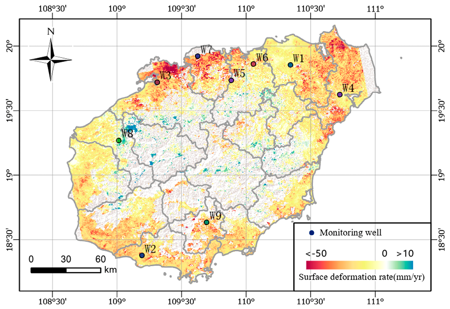
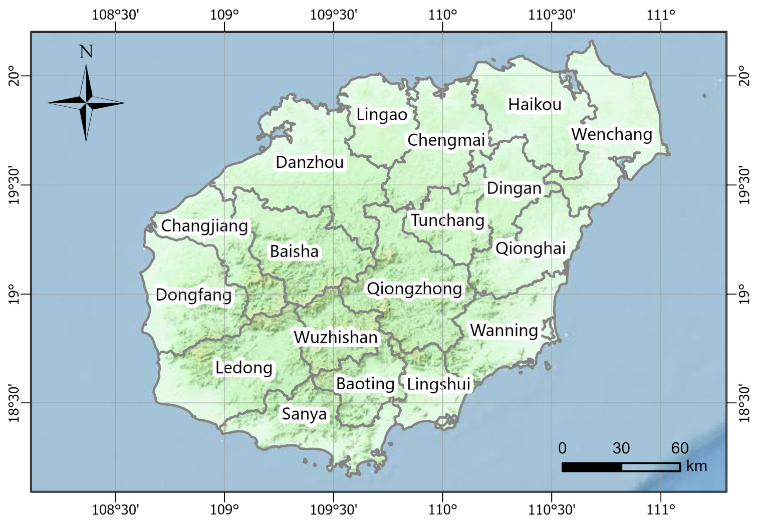
- Land subsidence in Hainan Province exhibits pronounced spatiotemporal heterogeneity, characterized by relatively stable central regions and concentrated coastal subsidence. From 2019 to 2023, subsidence was mainly distributed in coastal plain areas, including Haikou, Wenchang, and Danzhou, where multiple subsidence centers developed, with local average annual subsidence rates exceeding −50 mm/yr. The central mountainous region, dominated by bedrock landforms, shows no significant subsidence, and overall deformation remains stable.
- (2)
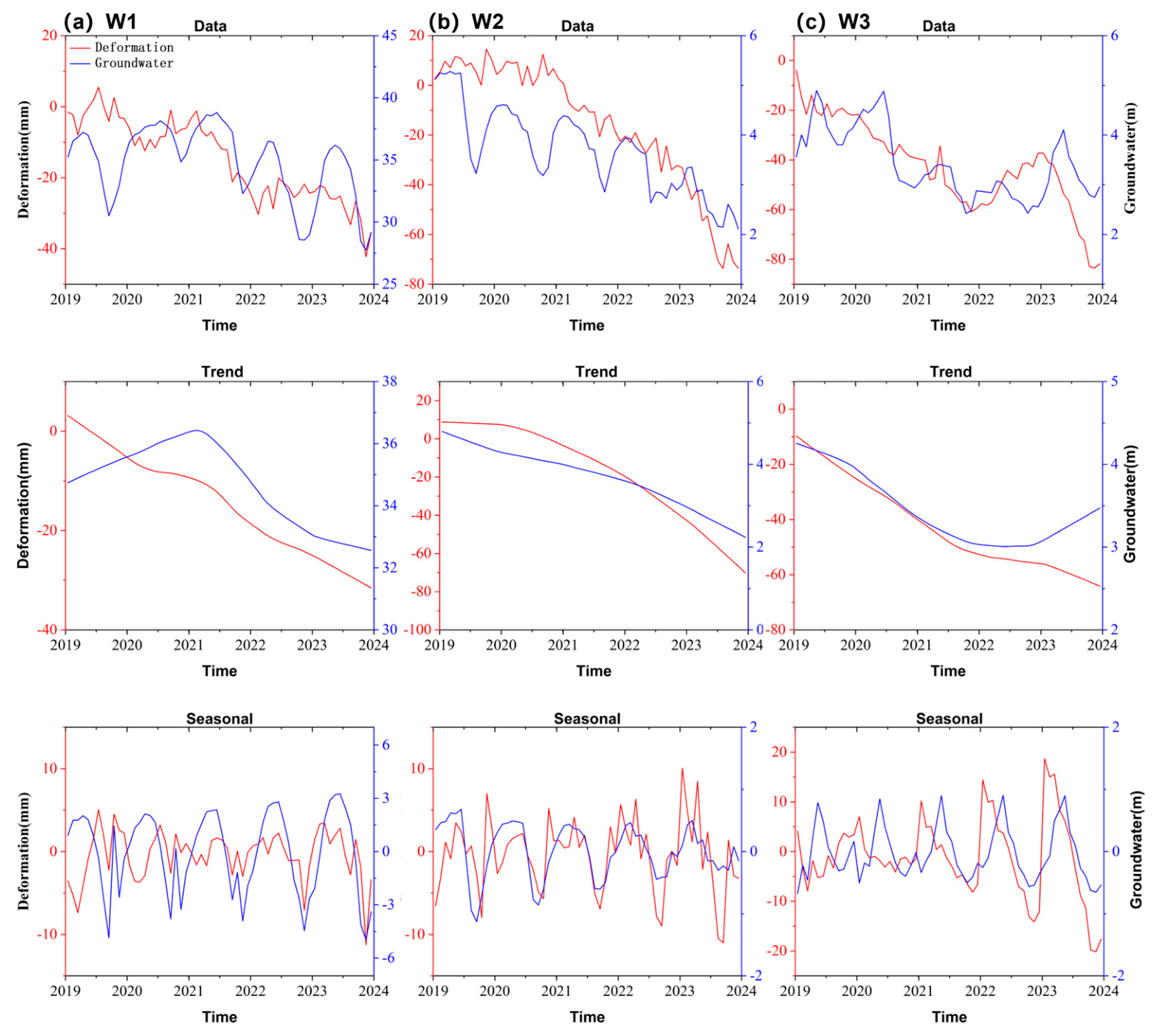
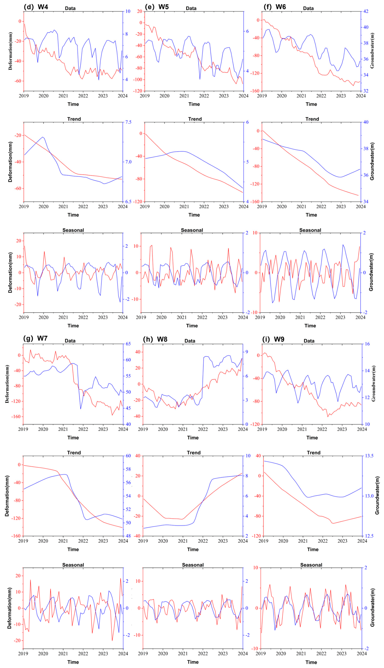
- At the selected representative monitoring wells, groundwater levels and land subsidence show strong consistency in their long-term trends. The trend components extracted via STL decomposition indicate that groundwater-level decline is closely synchronized with cumulative subsidence development. DTW distances for all selected monitoring wells are below 10, and Pearson correlation coefficients reach up to 0.98 or higher, indicating that groundwater depletion is an important factor controlling cumulative subsidence at the selected representative monitoring sites.
- (3)
- At the seasonal scale, land subsidence at the selected monitoring wells responds to groundwater-level fluctuations with a lag of 1–6 months, exhibiting significant spatial variability in both lag time and phase relationship. Coastal monitoring sites located in severe subsidence areas are characterized by medium- to long-lag responses of 3–6 months, whereas inland and low-subsidence monitoring sites are dominated by short-lag responses of approximately 1 month. These differences are closely related to aquifer structure, the distribution of low-permeability layers, groundwater extraction intensity, and seasonal recharge conditions.
- (4)
- The groundwater–subsidence response at representative monitoring sites is jointly controlled by long-term trends and seasonal variations. Long-term groundwater decline plays an important role in cumulative subsidence, while seasonal precipitation recharge and periodic groundwater extraction contribute to cyclic fluctuations in deformation. Soil consolidation and rebound processes exhibit evident time-lag effects. In some areas, subsidence decelerates or even shows slight rebound following groundwater-level recovery, reflecting both elastic and inelastic deformation behavior of the aquifer system.
- (5)
- The spatial heterogeneity of hydrogeological conditions strongly influences subsidence response patterns at the selected monitoring sites. In coastal plains, thick unconsolidated sediments and well-developed low-permeability layers result in slow groundwater flow and delayed deformation responses. In contrast, inland areas with relatively stable aquifer structures exhibit more rapid and sensitive deformation responses to groundwater-level variations. Collectively, these factors help explain the spatial variability of land subsidence response time lags in representative areas of Hainan Province.
Author Contributions
Funding
Data Availability Statement
Conflicts of Interest
References
- Galloway, D.L.; Burbey, T.J. Regional land subsidence accompanying groundwater extraction. Hydrogeol. J. 2011, 19, 1459–1486. [Google Scholar] [CrossRef] [Scilit]
- Herrera-García, G.; Ezquerro, P.; Tomás, R.; Béjar-Pizarro, M.; López-Vinielles, J.; Rossi, M.; Mateos, R.M.; Carreón-Freyre, D.; Lambert, J.; Teatini, P. Mapping the global threat of land subsidence. Science 2021, 371, 34–36. [Google Scholar] [CrossRef] [Scilit] [PubMed]
- Lin, Z.; Huili, G.; Xiaojuan, L.; Chaofan, Z.; Miao, Y.; Haigang, W.; Ke, Z.; Miaomiao, H. Research progress and prospect of land subsidence. Hydrogeol. Eng. Geol. 2024, 51, 167–177. [Google Scholar]
- An, Y.; Shen, Q.; Shum, C.; Gao, F.; Zhang, X.; Jiang, L.; Wang, H. TS-InSAR assessment of groundwater overexploitation-land subsidence linkage: Hengshui case study. J. Hydrol. Reg. Stud. 2025, 60, 102489. [Google Scholar]
- Zhang, R.; Wang, T.; Liu, G.; Shama, A.; Liu, A.; Wang, X.; Deng, L.; Mao, W. Ground subsidence evolution and groundwater variation in the middle route of south to north water diversion project. Sci. Rep. 2025, 15, 19220. [Google Scholar] [CrossRef] [Scilit] [PubMed]
- Meng, D.; Chen, B.; Gong, H.; Zhang, S.; Ma, R.; Zhou, C.; Lei, K.; Xu, L.; Wang, X. Land subsidence and rebound response to groundwater recovery in the Beijing Plain: A new hydrological perspective. J. Hydrol. Reg. Stud. 2025, 57, 102127. [Google Scholar] [CrossRef] [Scilit]
- Li, F.; Liu, G.; Gong, H.; Chen, B.; Zhou, C. Assessing land subsidence-inducing factors in the Shandong Province, China, by using PS-InSAR measurements. Remote Sens. 2022, 14, 2875. [Google Scholar] [CrossRef] [Scilit]
- Zebker, H.; Villasenor, J. Decorrelation in interferometric radar echoes. IEEE Trans. Geosci. Remote Sens. 1992, 30, 950–959. [Google Scholar] [CrossRef] [Scilit]
- Hanssen, R.F. Radar Interferometry: Data Interpretation and Error Analysis; Springer: Cham, Switzerland, 2001. [Google Scholar]
- Patra, S.R.; Chu, H.-J.; Tatas. Employing machine learning to document trends and seasonality of groundwater-induced subsidence. Nat. Hazards 2025, 121, 5007–5031. [Google Scholar]
- Chaussard, E.; Wdowinski, S.; Cabral-Cano, E.; Amelung, F. Land subsidence in central Mexico detected by ALOS InSAR time-series. Remote Sens. Environ. 2014, 140, 94–106. [Google Scholar] [CrossRef] [Scilit]
- Tomás, R.; Li, Z.; Lopez-Sanchez, J.M.; Liu, P.; Singleton, A. Using wavelet tools to analyse seasonal variations from InSAR time-series data: A case study of the Huangtupo landslide. Landslides 2016, 13, 437–450. [Google Scholar]
- Dong, D.; Tao, B.; Zhang, T.; Huang, X.; Yuan, D.; Chen, F.; Zhang, P.; Zhao, X. Analyzing the Spatiotemporal Dynamics and Driving Mechanisms of Island Tourism: A Case Study of Hainan Island, China. Sustainability 2026, 18, 3498. [Google Scholar] [CrossRef] [Scilit]
- Zeng, D.; Solangi, K.A.; Solangi, F.; Song, X.; Anwar, M.; Liu, L.; Zhang, J.; Zhang, D. Spatial Assessment of Soil Properties and Soil Quality Dynamics (SFI and SQI) on Hainan Island Using Field Observations and Remote Sensing Data. Agriculture 2026, 16, 762. [Google Scholar] [CrossRef] [Scilit]
- Tay, C.; Lindsey, E.O.; Chin, S.T.; McCaughey, J.W.; Bekaert, D.; Nguyen, M.; Hua, H.; Manipon, G.; Karim, M.; Horton, B.P. Sea-level rise from land subsidence in major coastal cities. Nat. Sustain. 2022, 5, 1049–1057. [Google Scholar] [CrossRef] [Scilit]
- Berardino, P.; Fornaro, G.; Lanari, R.; Sansosti, E. A new algorithm for surface deformation monitoring based on small baseline differential SAR interferograms. IEEE Trans. Geosci. Remote Sens. 2003, 40, 2375–2383. [Google Scholar]
- Mora, O.; Mallorqui, J.J.; Broquetas, A. Linear and nonlinear terrain deformation maps from a reduced set of interferometric SAR images. IEEE Trans. Geosci. Remote Sens. 2003, 41, 2243–2253. [Google Scholar] [CrossRef] [Scilit]
- Cleveland, R.B.; Cleveland, W.S.; McRae, J.E.; Terpenning, I. STL: A seasonal-trend decomposition. J. Off. Stat. 1990, 6, 3–73. [Google Scholar]
- Zhu, Z.; Woodcock, C.E. Continuous change detection and classification of land cover using all available Landsat data. Remote Sens. Environ. 2014, 144, 152–171. [Google Scholar] [CrossRef] [Scilit]
- Torrence, C.; Compo, G.P. A practical guide to wavelet analysis. Bull. Am. Meteorol. Soc. 1998, 79, 61–78. [Google Scholar] [CrossRef] [Scilit]
- Berndt, D.J.; Clifford, J. Using dynamic time warping to find patterns in time series. In Proceedings of the 3rd International Conference on Knowledge Discovery and Data Mining, Seattle, WA, USA, 31 July–1 August 1994; pp. 359–370. [Google Scholar]
- Erban, L.E.; Gorelick, S.M.; Zebker, H.A. Groundwater extraction, land subsidence, and sea-level rise in the Mekong Delta, Vietnam. Environ. Res. Lett. 2014, 9, 084010. [Google Scholar] [CrossRef] [Scilit]
- Chaussard, E.; Amelung, F.; Abidin, H.; Hong, S.-H. Sinking cities in Indonesia: ALOS PALSAR detects rapid subsidence due to groundwater and gas extraction. Remote Sens. Environ. 2013, 128, 150–161. [Google Scholar] [CrossRef] [Scilit]
- Wang, Y.; Peter, M.I.; Zhu, D.; Zhang, Y.; Tang, W. Coastal plain evolution in southern Hainan Island, China. Chin. Sci. Bull. 2001, 46, 90–96. [Google Scholar] [CrossRef] [Scilit]
- Borówka, R.K.; Miluch, J.; Maciąg, Ł.; Osadczuk, A.; Jiang, T.; Chen, H.; Harff, J.; Tomczak, M.; Osadczuk, K.; Bloom, K. Late Quaternary evolution of lower course river sections and coastal plains in the southwestern Hainan Island, South China Sea. Quat. Int. 2026, 759, 110144. [Google Scholar] [CrossRef] [Scilit]
- Poland, J.F. Guidebook to Studies of Land Subsidence Due to Ground-Water Withdrawal; UNESCO: Chelsea, MI, USA, 1984. [Google Scholar]
- Shirzaei, M.; Freymueller, J.; Törnqvist, T.E.; Galloway, D.L.; Dura, T.; Minderhoud, P.S. Measuring, modelling and projecting coastal land subsidence. Nat. Rev. Earth Environ. 2021, 2, 40–58. [Google Scholar]
- Li, L.; Lianjie, F.; Lixin, P.; Shengzhang, Z.; Yongsheng, L.; Rixin, D.; Zhe, W. Groundwater resources and environmental geologic problems on Hainan Island. Geol. China 2022, 51, 499–510. [Google Scholar]
- Li, G.; Feng, G.; Xiong, Z.; Liu, Q.; Xie, R.; Zhu, X.; Luo, S.; Du, Y. Surface deformation evolution in the Pearl River Delta between 2006 and 2011 derived from the ALOS1/PALSAR images. Earth Planets Space 2020, 72, 179. [Google Scholar] [CrossRef] [Scilit]
- Galloway, D.L.; Hudnut, K.W.; Ingebritsen, S.; Phillips, S.P.; Peltzer, G.; Rogez, F.; Rosen, P. Detection of aquifer system compaction and land subsidence using interferometric synthetic aperture radar, Antelope Valley, Mojave Desert, California. Water Resour. Res. 1998, 34, 2573–2585. [Google Scholar] [CrossRef] [Scilit]
- Yang, J.; Cao, G.; Han, D.; Yuan, H.; Hu, Y.; Shi, P.; Chen, Y. Deformation of the aquifer system under groundwater level fluctuations and its implication for land subsidence control in the Tianjin coastal region. Environ. Monit. Assess. 2019, 191, 162. [Google Scholar] [CrossRef] [Scilit] [PubMed]
- Wang, D.; Zhang, L.; Pei, L.; Li, X.; Yang, Y.; Chen, Z.; Liang, L. Chemical characteristics and controlling factors of shallow groundwater in the lower reaches of Changhua River basin, Hainan Island, China. Water 2023, 15, 3508. [Google Scholar] [CrossRef] [Scilit]
- Xu, J.; Cao, Y.; Liu, J.; Hou, J.; Yan, W.; Yi, C.; Jia, G. SBAS-InSAR Quantifies Groundwater–Urban Construction Evolution Impacts on Tianjin’s Land Subsidence. Geosciences 2026, 16, 57. [Google Scholar] [CrossRef] [Scilit]
- Hoffmann, J.; Leake, S.A.; Galloway, D.L.; Wilson, A.M. MODFLOW-2000 Ground-Water Model-User Guide to the Subsidence and Aquifer-System Compaction (SUB) Package; 2331-1258; US Geological Survey: Reston, VA, USA, 2003.
- Cao, Y.; Wei, Y.-n.; Fan, W.; Peng, M.; Bao, L. Experimental study of land subsidence in response to groundwater withdrawal and recharge in Changping District of Beijing. PLoS ONE 2020, 15, e0232828. [Google Scholar] [CrossRef] [Scilit] [PubMed]
- Tang, W.; Zhao, X.; Bi, G.; Chen, M.; Cheng, S.; Liao, M.; Yu, W. Quantifying seasonal ground deformation in Taiyuan basin, China, by Sentinel-1 InSAR time series analysis. J. Hydrol. 2023, 622, 129654. [Google Scholar] [CrossRef] [Scilit]
- He, Q.; Liu, H.; Wei, L.; Ding, J.; Sun, H.; Zhang, Z. Monitoring the Time-Lagged Response of Land Subsidence to Groundwater Fluctuations via InSAR and Distributed Fiber-Optic Strain Sensing. Appl. Sci. 2025, 15, 7991. [Google Scholar] [CrossRef] [Scilit]
- Sneed, M.; Galloway, D.L. Aquifer-System Compaction and Land Subsidence: Measurements, Analyses, and Simulations: The Holly Site, Edwards Air Force Base, Antelope Valley, California; US Department of the Interior, US Geological Survey: Reston, VA, USA, 2000.
- Li, P.; Wu, J.; Zhou, W.; LaMoreaux, J.W. Land Subsidence and Groundwater Seepage. In Hazard Hydrogeology; Springer: Cham, Switzerland, 2023; pp. 45–74. [Google Scholar]
- Zhao, X.; Tang, W.; Hao, G.; Zhao, H.; Xiong, W. Characterizing aquifer properties in the Taiyuan Basin, Northern China, using ground deformation from Sentinel-1 InSAR time series analysis. J. Hydrol. Reg. Stud. 2025, 58, 102313. [Google Scholar] [CrossRef] [Scilit]
- Wang, X.; Luo, Z.; Li, Z.; Zhao, Q.; Dai, J. The impact of groundwater recharge on land subsidence: A case study from the Cangzhou test area, Hebei Province, China. Hydrogeol. J. 2023, 31, 813–825. [Google Scholar] [CrossRef] [Scilit]
- Zhang, Y.; He, G.; Wu, J.; Zhu, Z.; Yan, X.; Yang, T. Experimental study on mechanism for pumping-induced land subsidence. Proc. Int. Assoc. Hydrol. Sci. 2020, 382, 387–390. [Google Scholar] [CrossRef] [Scilit]
- Yu, C.; Li, Z.; Penna, N.T.; Crippa, P. Generic atmospheric correction model for interferometric synthetic aperture radar observations. J. Geophys. Res. Solid. Earth 2018, 123, 9202–9222. [Google Scholar] [CrossRef] [Scilit]
- Fuhrmann, T.; Garthwaite, M.C. Resolving three-dimensional surface motion with InSAR: Constraints from multi-geometry data fusion. Remote Sens. 2019, 11, 241. [Google Scholar] [CrossRef] [Scilit]



| Data Type | Source | Parameter | Information |
|---|---|---|---|
| SAR (Sentinel-1A) | European Space Agency (ESA) | Beam mode/Width | IW/250 km |
| Polarization | VV | ||
| Acquisition periods | January 2019–December 2023 | ||
| Number of scenes | 131 | ||
| Monitoring well | China Institute of Geo-Environment Monitoring (CIGEM) | Number of monitoring wells | 9 |
| Temporal resolution | Monthly | ||
| Acquisition periods | January 2019–December 2023 |
| Well ID | Pearson r | DTW Distance |
|---|---|---|
| W1 | 0.7934 | 4.652 |
| W2 | 0.9882 | 0.4013 |
| W3 | 0.9061 | 2.9695 |
| W4 | 0.9272 | 3.1037 |
| W5 | 0.7615 | 2.205 |
| W6 | 0.9679 | 1.566 |
| W7 | 0.9196 | 4.3751 |
| W8 | 0.9185 | 3.8129 |
| W9 | 0.9431 | 1.6102 |
| Well ID | Optimal Lag (Months) | Correlation r |
|---|---|---|
| W1 | 4 | −0.245 |
| W2 | 6 | −0.409 |
| W3 | 5 | −0.569 |
| W4 | 4 | −0.412 |
| W5 | 3 | 0.332 |
| W6 | 4 | 0.334 |
| W7 | 1 | −0.394 |
| W8 | 1 | 0.47 |
| W9 | 1 | 0.74 |
Disclaimer/Publisher’s Note: The statements, opinions and data contained in all publications are solely those of the individual author(s) and contributor(s) and not of MDPI and/or the editor(s). MDPI and/or the editor(s) disclaim responsibility for any injury to people or property resulting from any ideas, methods, instructions or products referred to in the content. |
© 2026 by the authors. Licensee MDPI, Basel, Switzerland. This article is an open access article distributed under the terms and conditions of the Creative Commons Attribution (CC BY) license.
Share and Cite
Wang, H.; Yan, J.; Gong, H.; Zhang, S.; Chen, Z.; Chen, B.; Lei, K.; Liu, D. InSAR-Derived Spatiotemporal Evolution of Land Subsidence and Its Response to Groundwater Overexploitation in Hainan, China. Land 2026, 15, 1272. https://doi.org/10.3390/land15071272
Wang H, Yan J, Gong H, Zhang S, Chen Z, Chen B, Lei K, Liu D. InSAR-Derived Spatiotemporal Evolution of Land Subsidence and Its Response to Groundwater Overexploitation in Hainan, China. Land. 2026; 15(7):1272. https://doi.org/10.3390/land15071272
Chicago/Turabian StyleWang, Haigang, Jiuxin Yan, Huili Gong, Shubo Zhang, Zilin Chen, Beibei Chen, Kunchao Lei, and Dongyong Liu. 2026. "InSAR-Derived Spatiotemporal Evolution of Land Subsidence and Its Response to Groundwater Overexploitation in Hainan, China" Land 15, no. 7: 1272. https://doi.org/10.3390/land15071272
APA StyleWang, H., Yan, J., Gong, H., Zhang, S., Chen, Z., Chen, B., Lei, K., & Liu, D. (2026). InSAR-Derived Spatiotemporal Evolution of Land Subsidence and Its Response to Groundwater Overexploitation in Hainan, China. Land, 15(7), 1272. https://doi.org/10.3390/land15071272