1. Introduction
Contemporary heritage conservation policies increasingly emphasize the integrated protection of historical and cultural landscapes, with holistic conservation becoming a dominant paradigm in heritage practice [
1,
2]. Beyond monumental heritage sites and well-preserved historical remains, many vernacular settlements still retain cultural landscape remnants that, despite substantial material deterioration, continue to hold significant social and cultural value for local communities. Such landscapes are particularly evident in the southwestern frontier regions of China, where long-term interactions among diverse ethnic groups, environmental conditions, and historical processes have shaped distinctive cultural environments deeply embedded in everyday life. Although many of their physical features have gradually disappeared or become difficult to identify, these cultural landscapes often persist through ritual practices, collective memory, oral traditions, and other forms of community-based cultural transmission.
Cultural landscapes are increasingly understood not merely as visible physical environments but as dynamic socio-spatial systems produced through the interaction of nature, culture, and human agency [
3]. According to the European Landscape Convention (ELC), landscape is defined as “an area, as perceived by people, whose character is the result of the action and interaction of natural and/or human factors” [
4]. This definition highlights the central role of perception in landscape interpretation and evaluation [
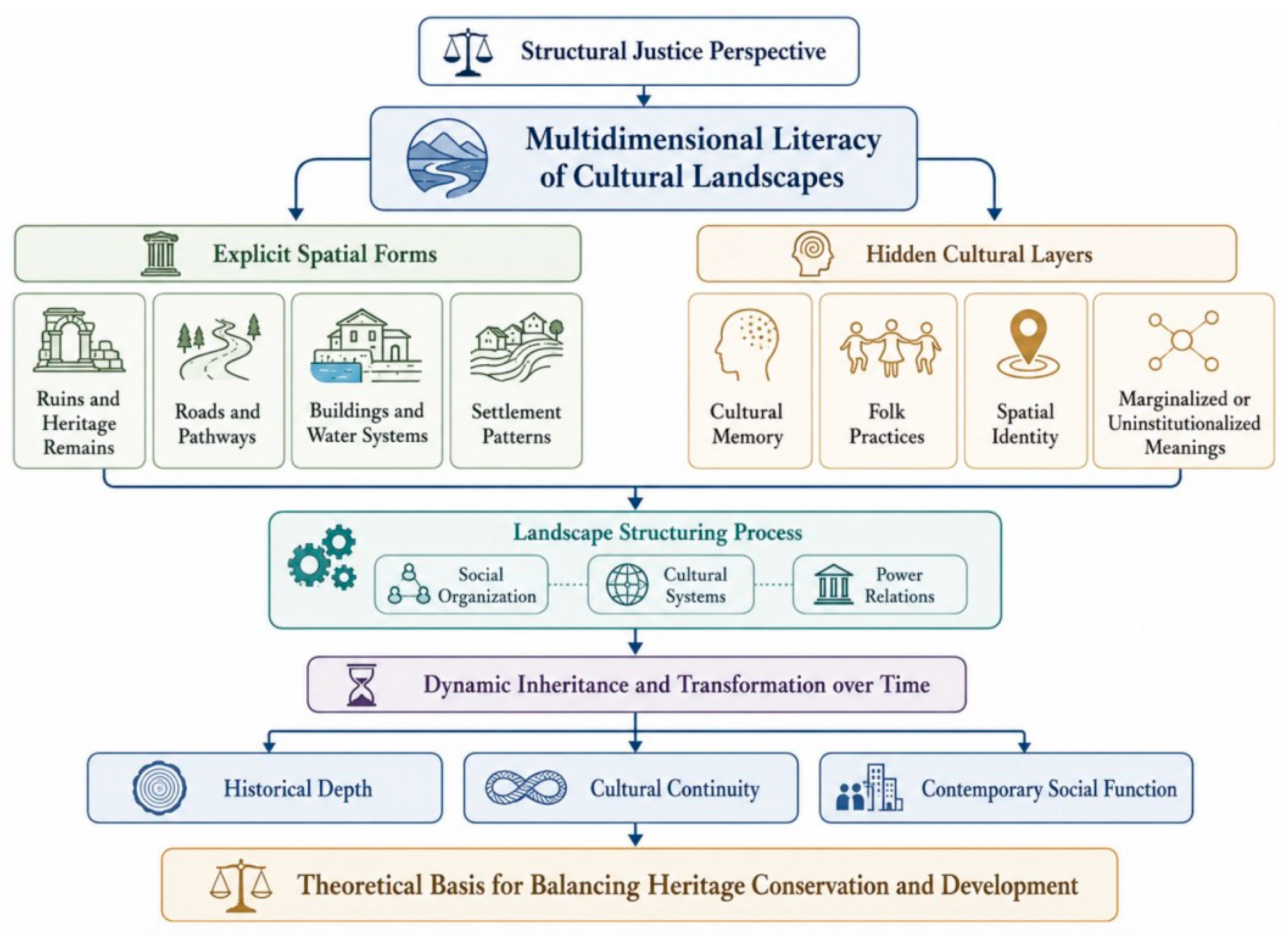
5]. From this perspective, cultural landscapes can be viewed as layered spatial systems shaped by the cumulative effects of natural processes, historical events, social organization, cultural institutions, social relations, and everyday practices [
6,
7,
8,
9,
10,
11]. Some of these layers remain visible through material elements such as archaeological remains, roads, buildings, water systems, settlement patterns, and other physical traces [
12]. Others are less tangible and persist through collective memory, ritual practices, local narratives, place names, sensory experiences, and habitual movement patterns [
13]. Moreover, cultural landscapes may exist not only as relatively stable spatial structures but also as dynamic cultural expressions associated with ritual activities, seasonal practices, political events, and temporary symbolic arrangements [
14]. As a result, their cultural significance may endure even when material forms have been fragmented, transformed, or partially lost. In many vernacular settlements, traces of former religious spaces, ritual routes, sacred sites, and communal gathering places continue to shape local identity and spatial behavior despite the disappearance of their original architectural structures.
Recent scholarship has examined the complexity of cultural landscapes from multiple perspectives, including landscape characteristics, cultural values, landscape narratives, heritage regeneration, and spatial information systems [
15,
16,
17,
18]. At the same time, interdisciplinary research in anthropology, sociology, and human geography has expanded attention to landscape structure, landscape perception, spatial justice, and the relationships between landscapes and social organization [
19,
20,
21]. These studies demonstrate that landscapes should be understood not only as physical environments but also as products of social interaction, cultural practice, and collective memory. Against this background, increasing attention has been directed toward cultural landscapes whose significance extends beyond visible material forms. In particular, the concept of “implicit” or “hidden” cultural landscapes has emerged as an important perspective for understanding how cultural meanings, social memories, and place identities continue to persist even when their physical manifestations have been partially lost, transformed, or obscured.
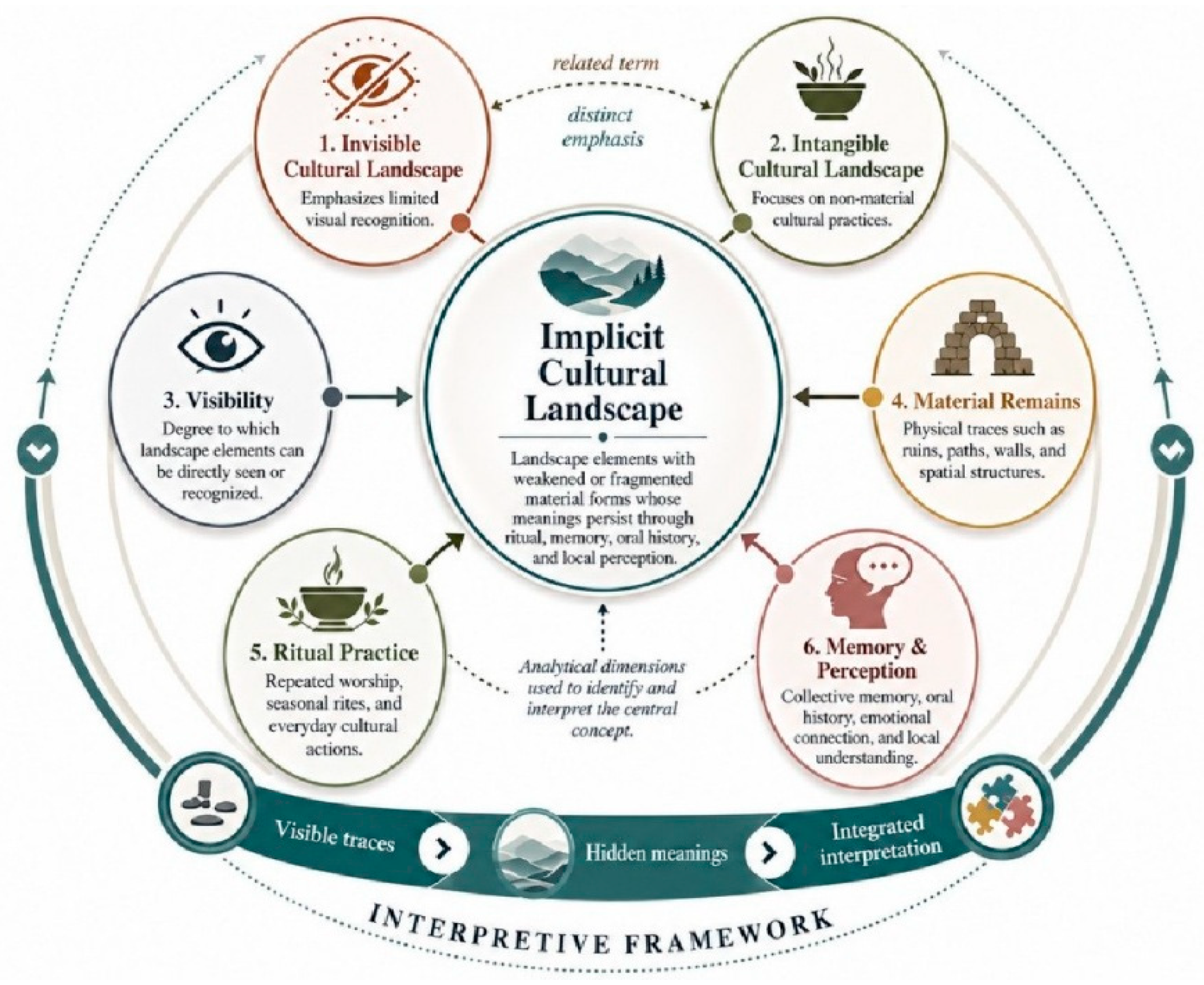
Implicit cultural landscapes refer to spatial structures whose cultural significance persists through social practices, collective memory, ritual activities, and cultural traditions, even when their material forms have become fragmented, transformed, or largely disappeared [
22,
23,
24]. Rather than being expressed through clearly identifiable physical features, such landscapes are embedded in everyday life and continuously reproduced through recurring social practices. This understanding is consistent with Giddens’ theory of structuration, which emphasizes the reciprocal relationship between social practices and spatial structures [
25]. Social structures are continually produced and reproduced through human actions, while human practices simultaneously shape and transform the spaces in which they occur. From this perspective, implicit cultural landscapes can be understood as the outcome of long-term interactions between cultural practices and spatial environments. Although they may leave only limited material traces, they continue to influence local perceptions, place attachment, social relations, and patterns of spatial behavior.
Despite substantial progress in cultural landscape research, several important gaps remain. Existing studies have largely focused on visible heritage remains, landscape morphology, and physical conservation strategies, while giving comparatively less attention to landscapes whose meanings are sustained through collective memory, ritual practices, and community perception [
26]. Although the social dimensions of landscape have received increasing scholarly attention, research that systematically combines field observation, oral history, and perception analysis to examine how local communities recognize, interpret, and experience implicit cultural landscapes is still relatively limited. Furthermore, vernacular settlements in the southwestern frontier regions of China remain insufficiently represented in the literature, particularly with regard to the role of implicit cultural landscapes in maintaining local identity, cultural continuity, and place attachment.
To address these research gaps, this study takes Gucheng Village in the Baiya City area of the Zhaozhou Basin, Dali, Yunnan, as a case study. The research focuses on the remains of an “Ancient Temple,” a site whose architectural structures have largely disappeared but which continues to occupy an important position in local memory, ritual practices, and community life. By integrating field investigation, oral history interviews, and Semantic Differential (SD) analysis, this study explores how local communities perceive, interpret, and maintain this implicit cultural landscape. The study aims to identify the key factors shaping landscape perception, reveal the cultural significance embedded within the site, and examine the role of implicit cultural landscapes in sustaining local identity and cultural continuity. Specifically, the following research questions are addressed:
How can implicit cultural landscapes be identified and interpreted in vernacular settlements where material forms have been partially lost?
How can spatial perception analysis contribute to understanding the cultural values, place meanings, and social significance embedded within implicit cultural landscapes?
By addressing these questions, this study seeks to deepen understanding of the relationships among cultural memory, spatial perception, and cultural landscape conservation. It also provides empirical evidence for heritage conservation and regeneration strategies that extend beyond the protection of material remains and recognize the continuing role of local communities in sustaining and reproducing cultural meanings within landscapes.
The remainder of this paper is organized as follows. First, the theoretical foundations of cultural landscapes, landscape perception, and implicit cultural landscapes are reviewed. Next, the study area and its historical, spatial, and sociocultural context are introduced. The research design and methods, including field investigation, oral history interviews, and Semantic Differential (SD) analysis, are then presented. This is followed by an analysis of local perceptions of the Ancient Temple remains and related cultural landscape spaces. Finally, the study discusses the implications of the findings for cultural landscape conservation and regeneration and summarizes the main conclusions.
4. Research Methodology
4.1. Research Methodology and Framework
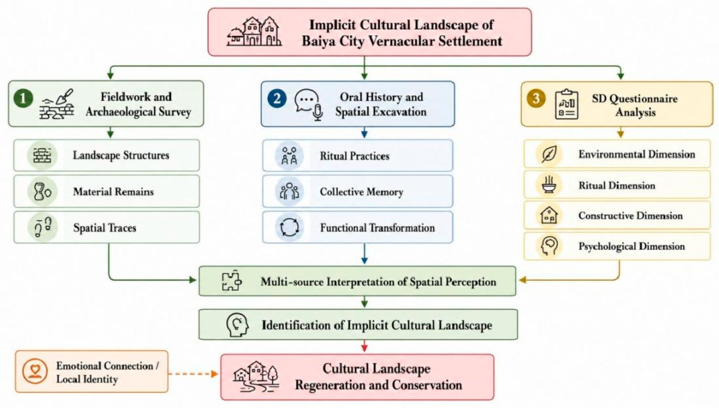
This study constructs a methodological framework for identifying and interpreting the implicit cultural landscapes of the Baiya City vernacular settlement by integrating field investigation and spatial survey, oral history and spatial excavation, and SD questionnaire analysis. First, field investigation and spatial survey were used to examine the visible material basis of the landscape. Through on-site observation, spatial mapping, photographic recording, and the investigation of existing remains, the study identified landscape structures, material remains, settlement patterns, ritual routes, and spatial traces related to the Ancient Temple site. This step provided the physical and spatial foundation for understanding how implicit cultural meanings are embedded in visible landscape forms. All oral history interviews were conducted with informed consent, and all interviewees were anonymized in accordance with ethical research requirements.
Second, oral history and spatial excavation were applied to reveal cultural meanings that are not directly visible in material remains. Field investigations referred to noninvasive surveys and spatial mapping rather than formal archaeological excavations, focusing on documenting visible features, spatial organization, and ritual sites. In order to ensure the reliability and representativeness of the oral materials, the interviewees were identified through purposive sampling combined with snowball sampling. Priority was given to local villagers who had lived in or near the Ancient Temple site for a long period; were familiar with its historical changes, ritual activities, spatial use, and local customs; or had participated in related community practices. Elderly residents, ritual participants, village representatives, and individuals with knowledge of the local history were therefore selected as key informants. Through semi-structured interviews, the study collected narratives concerning ritual practices, collective memory, local beliefs, and the functional transformation of the Ancient Temple site. These oral materials helped reconstruct the relationship between historical space, everyday life, and local identity. They also made it possible to understand how ritual routes, remembered places, and emotional connections continue to sustain the cultural significance of the site.
In addition, questionnaire surveys were conducted to supplement the qualitative findings and to understand broader community perceptions of the site. The participants were selected from residents and visitors who had direct experience of the Ancient Temple site or were familiar with its cultural and spatial environment. The selection criteria included residence or long-term activity in the surrounding area, knowledge of local cultural practices, willingness to participate, and the ability to provide valid responses. The questionnaire focused on respondents’ perceptions of spatial value, cultural memory, ritual significance, conservation awareness, and future reuse expectations. By combining oral history interviews with questionnaire surveys, the study was able to cross-validate individual memories, collective perceptions, and spatial evidence, thereby improving the credibility of the interpretation.
Third, the SD questionnaire was used to evaluate local spatial perception across four dimensions: environment, ritual, construction, and psychology. By comparing villagers’ perceptual responses with the results of field observation and oral history analysis, the study developed a multi-source interpretation of spatial perception. This integrated framework reduces the limitations of relying on a single type of evidence and enables implicit cultural landscapes to be identified through the interaction of material remains, memory narratives, emotional connections, and local perceptions (
Figure 6). Based on this framework, the study further explores strategies for cultural landscape regeneration and conservation that emphasize local identity, ritual continuity, and the preservation of indigenous spatial order.
Since 2023, the research team has conducted a three-month field investigation in Gucheng Village, located in Baiya City within the Zhaozhou Basin. The study adopts an integrated methodological approach combining field surveys, oral history investigation, and Semantic Differential (SD) analysis based on questionnaire data. The research focuses on the implicit cultural landscape of the vernacular settlement, taking the “Ancient Temple Ruins” as the core case for examining local spatial perception. Field investigations were first carried out to document the integrated village–city landscape pattern, including the spatial layout of the settlement and its environmental characteristics. Based on these observations, the structural features of the cultural landscape were analyzed within their historical context, with particular attention given to material evidence such as architectural remains in order to interpret the relationships between tangible and intangible landscape elements. Subsequently, oral history interviews were conducted with local residents to collect primary data on landscape spaces, ritual practices, and belief systems. This process aimed to document collective memory and narratives related to historical transformation, everyday life, and social change associated with the cultural landscape [
33,
34]. On this basis, questionnaire surveys were implemented, and the SD method was applied to further analyze local perceptions of the cultural landscape. By examining respondents’ emotional attitudes and cognitive evaluations of specific spaces, the study identified key perceptual factors across four dimensions: environment, ritual, construction, and psychology. These dimensions provided a framework for the systematic analysis of spatial perception elements. The integrated analysis of field surveys, oral histories, and SD assessment provides a basis for understanding how local communities perceive landscape space, relate to historical heritage, and assign value to cultural landscapes, thereby supporting the identification and interpretation of implicit cultural landscapes and informing strategies for their conservation and regeneration.
4.2. Fieldwork and Archaeological Survey
4.2.1. Village–City Framework
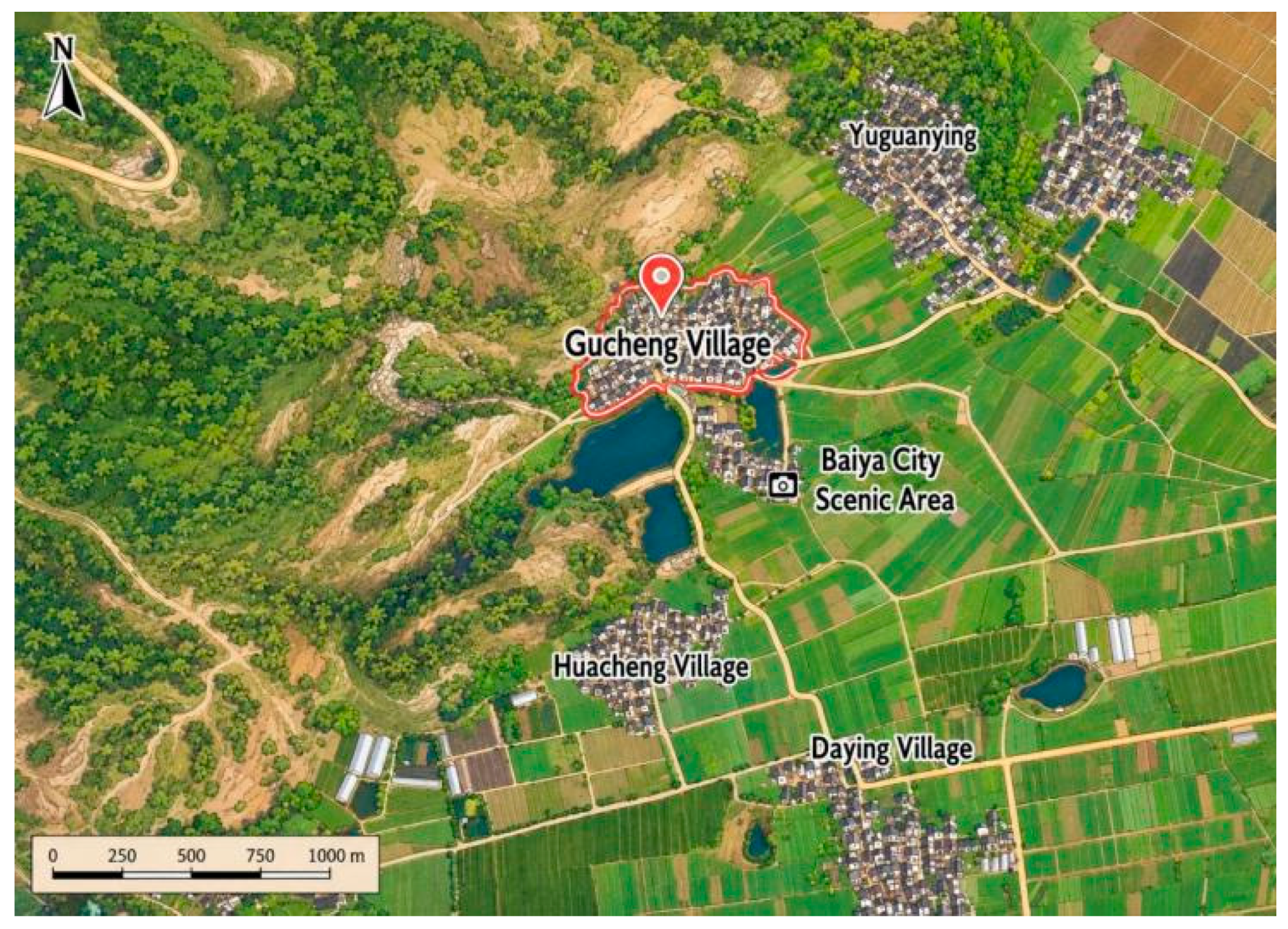
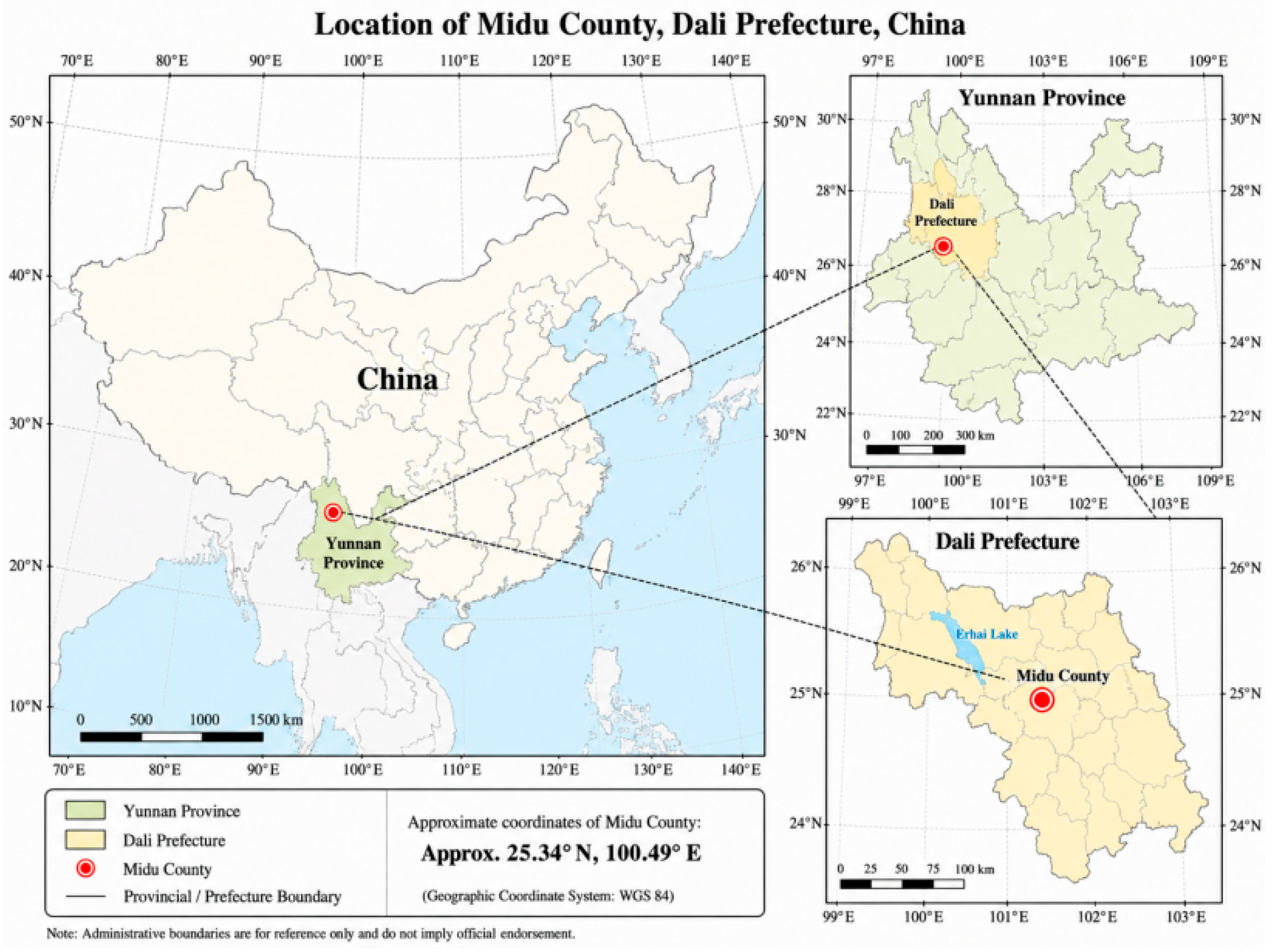
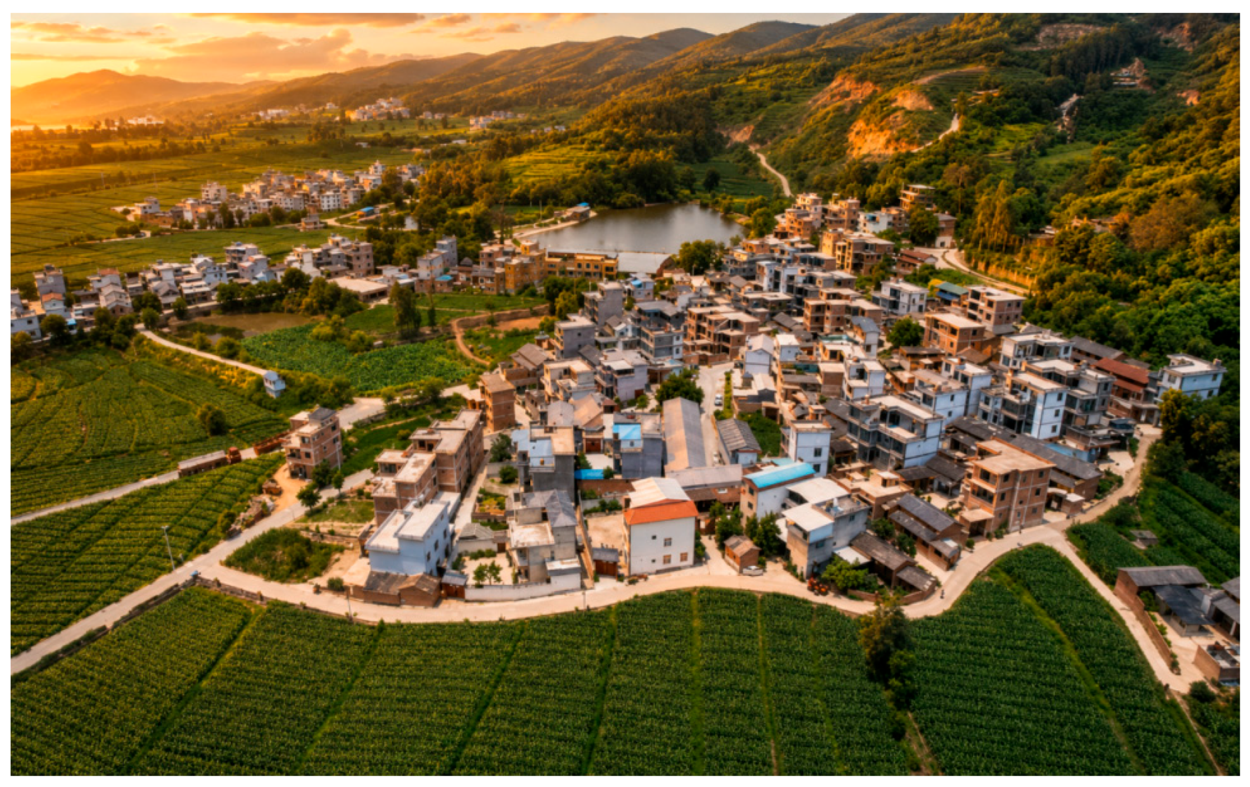
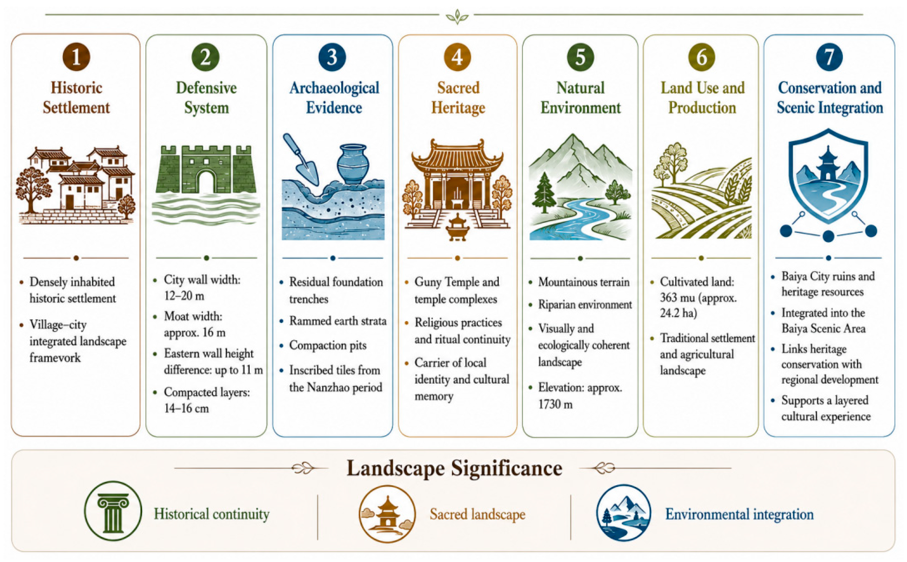
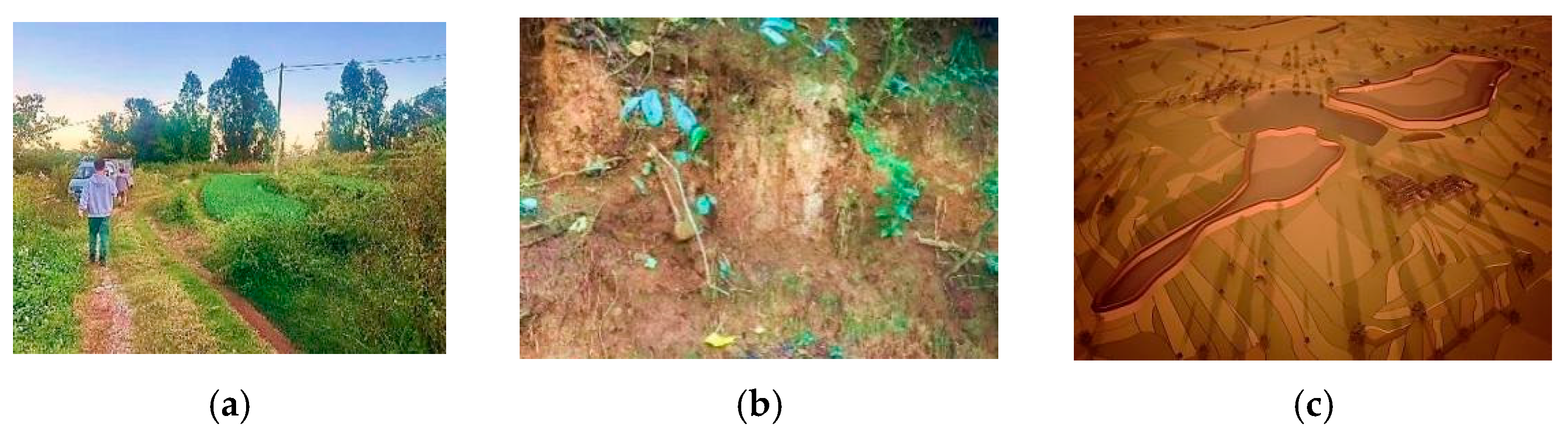
The ancient village represents a typical village–city integrated landscape configuration that historically functioned as a densely inhabited settlement. Field investigations conducted in November 2024 identified significant archaeological evidence along the residual foundation trenches of the city walls, including rammed-earth strata and compaction pits. Together with locally excavated inscribed tiles dating to the Nanzhao Kingdom, these findings indicate the former scale and historical importance of the settlement. Further on-site measurements documented the extent and structural characteristics of the defensive system. The moat surrounding Baiya New City was identified, with an approximate width of 16 m. A vertical height difference of up to 11 m was recorded between the eastern city wall and the surrounding ground surface. The city wall ranges from 12 to 20 m in width, with compacted layers approximately 14–16 cm thick. These physical remains provide important evidence for reconstructing the spatial organization and construction techniques of the historic settlement. Administratively, the settlement belongs to the Daying Village Committee of Hongyan Town, Dali, and contains 363 mu (approximately 24.2 ha) of cultivated land at an elevation of about 1730 m. The site is situated within a landscape setting characterized by the close integration of mountainous terrain, water systems, and settlement space. In recent years, heritage conservation and tourism development initiatives have promoted the protection and management of key cultural resources, including the Baiya City ruins and the Gunv Temple. These heritage sites have been incorporated into the broader Baiya Scenic Area, forming a cultural landscape system that links archaeological remains, vernacular settlements, and contemporary community activities. The spatial organization of temple complexes and their relationship with the surrounding environment reflect the long-term interaction between religious practices and landscape development. As important cultural landmarks, these sites continue to play a role in local cultural activities and contribute to the preservation of historical memory and place identity. Together, the archaeological remains, religious spaces, and natural environment form an interconnected cultural landscape that provides an important context for examining implicit cultural landscapes in the Baiya City area (
Figure 7 and
Figure 8).
4.2.2. Oral History and Spatial Excavation
- (1)
Discovery of Well-Preserved Temples
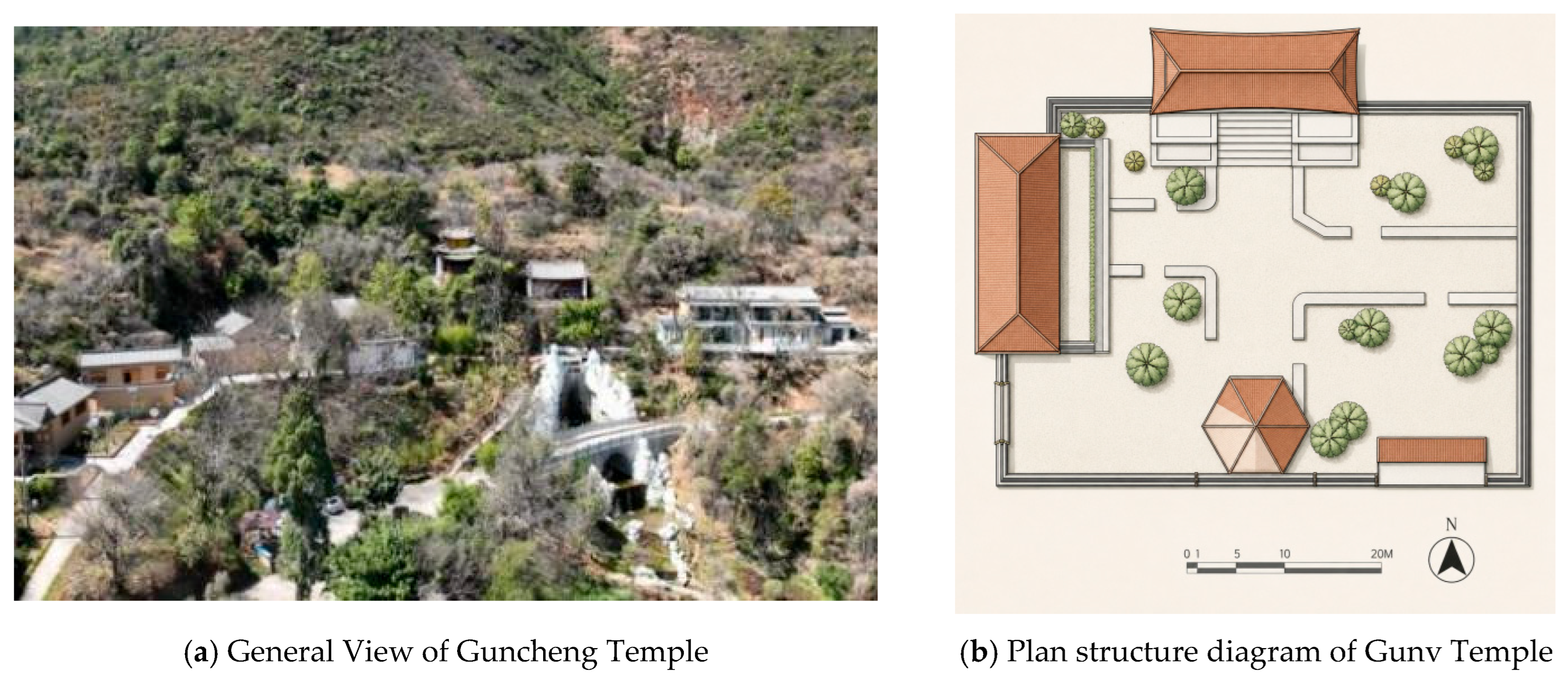
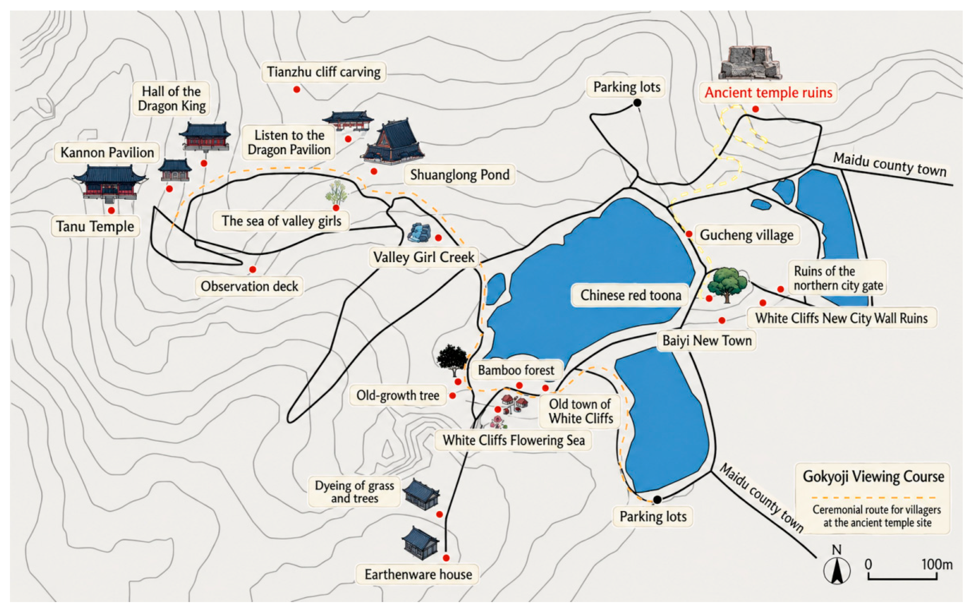
The landscape structure of the ancient village is closely associated with the surrounding mountainous terrain and dense forest environment, forming a spatial system that is closely linked to the historical settlement. Within this system, the sacred landscape constitutes an important structural component shaped by long-term religious practices. The most prominent element of this sacred landscape is the Gunv Temple, located on the mountain above the village. The temple adopts a terraced spatial layout that provides extensive views of the surrounding landscape and establishes a close spatial relationship between the natural environment and religious space. Historical records, including the
Wanli-era Zhaozhou Chronicles of the Ming Dynasty and surviving stone inscriptions, indicate that the temple was constructed no later than 1585 and has undergone multiple phases of restoration. The spatial organization of the temple complex reflects both deliberate planning and long-term adaptation to local environmental and cultural conditions. Visitors access the site through winding paths that pass by the Gunv Stream and cultivated flower fields. The presence of a freshwater spring and surrounding old-growth forest contributes to the environmental setting of the site. The architectural layout follows a symmetrical axial configuration, with the main hall positioned at the center and auxiliary structures arranged on either side, which currently serve as monastic residences. Although originally established as a religious space, the Gunv Temple has gradually developed into a landscape that accommodates both pilgrimage activities and tourism functions. Field observations indicate that residents from surrounding settlements continue to conduct ritual practices at the site, demonstrating its continuing role in local religious and cultural life. The temple therefore represents an important landscape element through which natural features, religious traditions, and cultural memory are interconnected (
Figure 9).
- (2)
Identification of Hidden Temple Spaces
Implicit cultural landscapes are formed and sustained through the repeated practices and ritual behaviors of local communities, functioning as important spatial carriers of collective memory and cultural identity [
8]. In Gucheng Village, Dali, traditional religious rituals provide key evidence for identifying such landscapes, with the Ancient Temple ruins located in the northern mountains of the village representing the most prominent example. Based on participatory identification by local villagers and oral history interviews, this study reconstructs a ceremonial pathway connecting the settlement to the hillside temple. The route is concealed within a forested landscape characterized by steep slopes and dense vegetation. Although the pathway has largely lost its physical integrity and receives little maintenance, it continues to be used by villagers and remains an important ritual corridor. As one 62-year-old villager explained, entering the forest signals proximity to the site, and despite decades of limited maintenance, the route can still be recognized through long-term familiarity with specific trees, landmarks, and other landscape features.
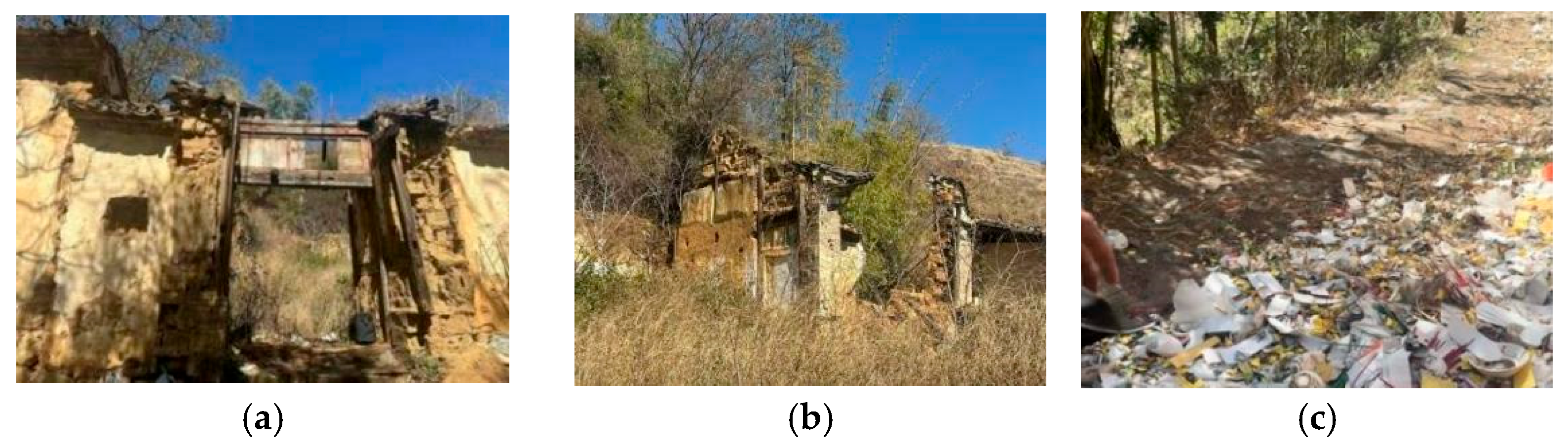
At the end of this pathway are the remains of the Ancient Temple, where only portions of the entrance structure and rammed-earth walls remain. Despite the limited preservation of its material fabric, the site continues to retain an important ritual function. Field observations documented ongoing worship activities, as evidenced by ritual objects such as incense burners, ceramic vessels, fruit offerings, and rice bowls. Oral accounts indicate that three major ritual events are held annually, corresponding to the eighth day of the first lunar month, the third day of the third lunar month, and the fifteenth day of the seventh lunar month. During these occasions, villagers collectively conduct ceremonies dedicated to mountain deities, earth gods, and ancestors. Ritual activities typically include incense burning, offerings, prayers, and prostration, often accompanied by the transmission of local legends, ritual knowledge, and customary taboos by village elders.
These practices are organized at the household level rather than through formal institutional structures, resulting in a decentralized ritual system that has been maintained across generations. Through such practices, the temple ruins extend beyond their physical condition and function as symbolic nodes that structure temporal rhythms, belief systems, and social relationships within the community.
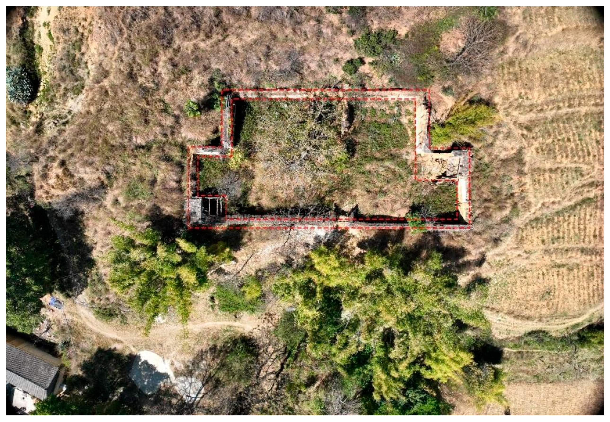
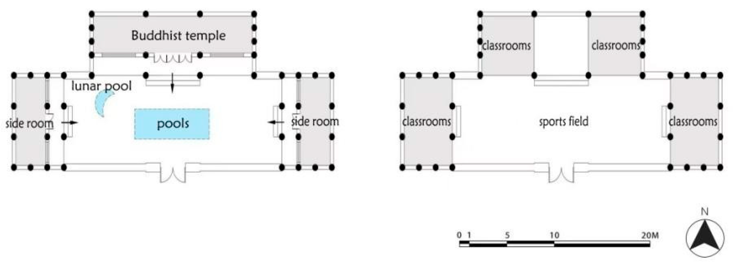
Oral histories further reveal the evolving functions of the site. According to local accounts, the site was originally constructed as a Buddhist temple during the Republican period of China (1912–1949), as shown in
Figure 7 and
Figure 8. It was later repurposed as a village school, reflecting the overlap of religious and secular functions within the local community. This transformation illustrates the adaptability of spatial functions in response to changing social needs. Villagers recall that the original structure featured a three-bay layout with a pitched roof and a crescent-shaped central pond, representing a form of vernacular mountain architecture integrated with its natural surroundings. Although much of the physical structure has disappeared, the cultural meanings associated with the site remain embedded in collective memory. The Ancient Temple continues to exist as an implicit cultural landscape whose significance is sustained through memory, ritual practices, and intergenerational transmission. In this sense, the site demonstrates how cultural meanings can persist and be reproduced despite the substantial loss of material fabric (
Figure 10,
Figure 11,
Figure 12 and
Figure 13).
4.3. SD Scale Analysis
4.3.1. Establishment of Evaluation Factors
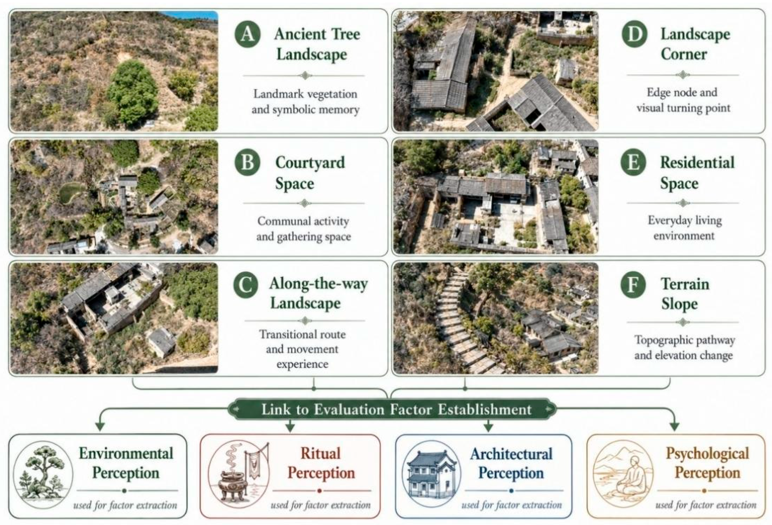
This study employs the Semantic Differential (SD) method to quantitatively examine local spatial perceptions of the “Ancient Temple” as an implicit cultural landscape. The SD method translates subjective perceptions into measurable data through the use of bipolar adjective pairs, enabling the systematic analysis of individual attitudes and preferences toward specific spatial environments. Data were collected through a three-month survey conducted using Wenjuanxing, focusing on villagers’ perceptions of the temple and its surrounding landscape. Preliminary aerial surveys were undertaken to identify key spatial nodes, including ancient tree areas, courtyard spaces, slope pathways, scenic viewpoints, transitional landscape zones, and residential areas (
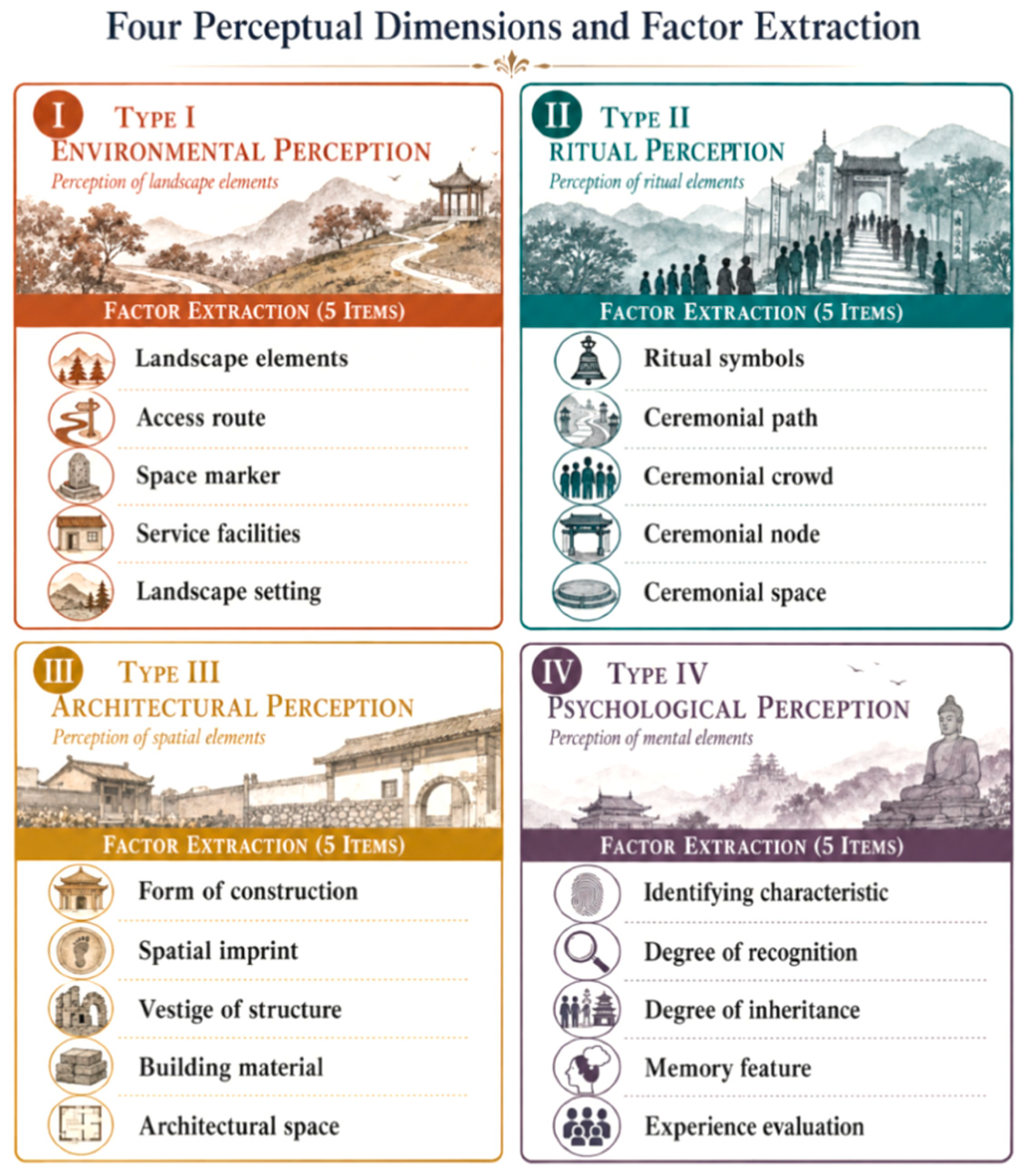
Figure 14). A combination of purposive sampling and snowball sampling was applied, resulting in interviews with 105 villagers aged between 20 and 80, with balanced representation across gender, occupation, and residential location. Responses frequently referred to the temple’s spatial environment, architectural features, and ritual spaces when describing local perceptions of the site. Based on content analysis, four principal perceptual dimensions were identified: environmental perception, ritual perception, architectural perception, and psychological perception. These dimensions provided the basis for the construction of the SD evaluation framework and subsequent analysis of local spatial perception.
The classification of these four perceptual dimensions is grounded in environmental perception theory and cultural landscape studies, which emphasize that spatial experience is shaped through the interaction of the physical environment, cultural practices, built forms, and cognitive–emotional responses. The environmental and architectural dimensions reflect the physical and material characteristics of a place, whereas the ritual and psychological dimensions capture the cultural meanings, social values, and subjective experiences embedded in spatial practices. This classification is consistent with Lynch’s theory of imageability and mental mapping, which highlights the role of environmental form in shaping spatial cognition, as well as Norberg-Schulz’s concept of
genius loci, which emphasizes the integration of physical setting and existential meaning in place experience [
35,
36]. Based on these theoretical foundations and the results of the preliminary interviews, the four dimensions were operationalized into 20 bipolar adjective pairs using a Semantic Differential (SD) scaling framework to evaluate local perceptions of the Ancient Temple landscape (
Figure 15,
Table 1).
4.3.2. Formation of the Differential Scale
A seven-point Semantic Differential (SD) scale was adopted to evaluate villagers’ and visitors’ perceptions of the Ancient Temple site. The scale ranged from −3 to +3, where −3 represented the strongest tendency toward the negative adjective, 0 indicated a neutral perception, and +3 represented the strongest tendency toward the positive adjective. Each evaluation item consisted of a pair of bipolar adjectives related to spatial atmosphere, historical memory, ritual significance, environmental quality, and cultural identity. Respondents were asked to select the score that best reflected their perceptions based on their direct experience of the village and the temple site.
The adjective pairs were not determined after data collection but were developed prior to the survey through field observation, oral history materials, and a review of existing studies on cultural landscape perception. To ensure the appropriateness of the evaluation framework, the preliminary indicators were reviewed by three researchers with expertise in architectural heritage, rural settlement studies, and cultural landscape research. A pilot survey was subsequently conducted with local residents to assess the clarity and comprehensibility of the questionnaire, and ambiguous or overly technical expressions were revised accordingly (
Figure 16).
During the formal survey, all scores were assigned directly by the respondents. Members of the research team provided explanations of the questionnaire when necessary but did not influence respondents’ choices. Following data collection, all questionnaires were checked for completeness, logical consistency, and invalid responses. Questionnaires containing substantial missing data, repeated mechanical scoring, or obvious contradictions were excluded from further analysis. Where the validity of a response was uncertain, at least two researchers independently reviewed the questionnaire before reaching a final decision. These procedures helped ensure that the SD scores accurately reflected participants’ spatial perceptions while maintaining the reliability and validity of the dataset [
29].
Before evaluating specific perceptual factors, the questionnaire included a preliminary screening and importance assessment regarding respondents’ relationship with the Ancient Temple site. Respondents were first asked whether they were familiar with and concerned about the site and were then invited to assess its importance in relation to daily life, collective memory, ritual participation, and local identity. This preliminary assessment helped determine whether respondents had meaningful experiential or perceptual connections with the site and provided a contextual basis for interpreting their subsequent evaluations of spatial atmosphere, cultural memory, ritual significance, conservation value, and future reuse expectations.
A seven-point Semantic Differential (SD) scale was adopted, ranging from −3 to +3, with negative and positive values representing opposing perceptual tendencies and 0 indicating a neutral position. This symmetrical scale enabled the quantification of perceptual differences and facilitated comparative analysis across multiple perceptual variables.
4.3.3. Survey Data and Demographics
A total of 189 questionnaires were distributed across Baiya City and the ancient village. After excluding incomplete or inconsistent responses, 161 valid questionnaires were retained, yielding a response rate of 85.18% (
Table 2). The sample provides a reliable basis for subsequent statistical analysis.
4.3.4. Reliability and Validity Analysis
Psychometric testing was conducted using SPSS (Version 22.0) to assess the reliability and validity of the questionnaire (
Table 3 and
Table 4) [
41,
42]. The Cronbach’s alpha coefficient for the 20 SD items was 0.964, indicating excellent internal consistency. Construct validity was evaluated through exploratory factor analysis, supported by the Kaiser–Meyer–Olkin (KMO) measure and Bartlett’s test of sphericity. The KMO value was 0.960, indicating excellent sampling adequacy, while Bartlett’s test yielded statistically significant results, confirming sufficient correlations among the variables. These results suggest that the questionnaire data are reliable and suitable for subsequent statistical analysis.
The results of the reliability and validity analyses indicate that the questionnaire data satisfy the requirements for factor analysis and provide a sound basis for subsequent statistical analysis and interpretation [
43,
44].
4.3.5. Descriptive Statistical Analysis
Descriptive statistics of the perceptual factors are presented in
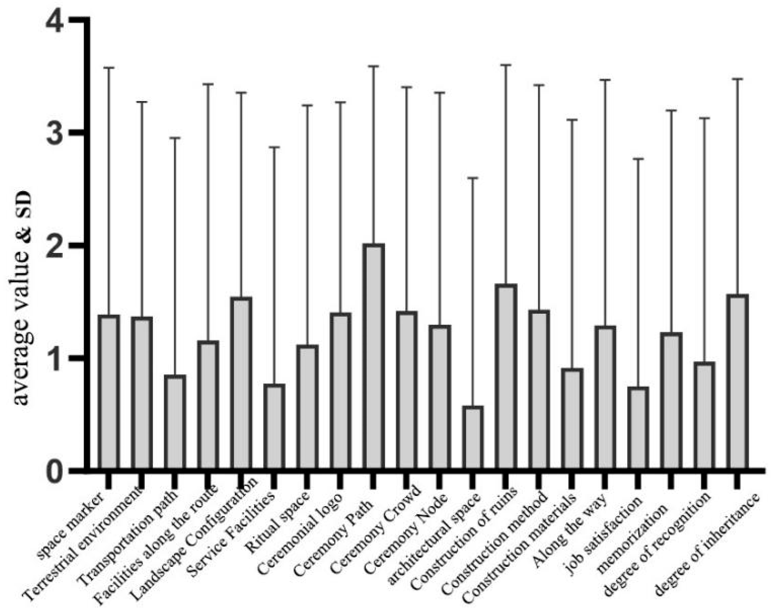
Table 5. Visualization using GraphPad Prism (Version 10.1.2) indicates that the mean values of all perceptual indicators were above the neutral level, with no factor scoring below zero (
Figure 17). These results suggest an overall positive perception of the spatial environment associated with the Ancient Temple. Among the evaluated variables, ritual pathway (M = 2.020), architectural remnants (M = 1.660), and landscape configuration (M = 1.550) received the highest scores, indicating strong recognition of ritual continuity and residual spatial features. In contrast, structural visibility (M = 0.580), satisfaction (M = 0.750), amenities (M = 0.780), and accessibility (M = 0.860) received comparatively lower scores, reflecting relatively limited physical conditions and supporting facilities. Intermediate scores were observed for spatial landmarks (M = 1.390) and overall landscape characteristics (M = 1.370). Overall, the results indicate that although the material integrity of the Ancient Temple ruins has declined, local communities continue to maintain relatively strong perceptions of its cultural and spatial significance.
5. Results
5.1. Overview of Dimensional Perception
This section integrates the SD results with field observations and oral history materials to examine how local communities perceive the Ancient Temple site as an implicit cultural landscape. Rather than simply reporting descriptive statistics, the analysis focuses on the relationships among quantitative perception patterns, material remains, ritual practices, and collective memory.
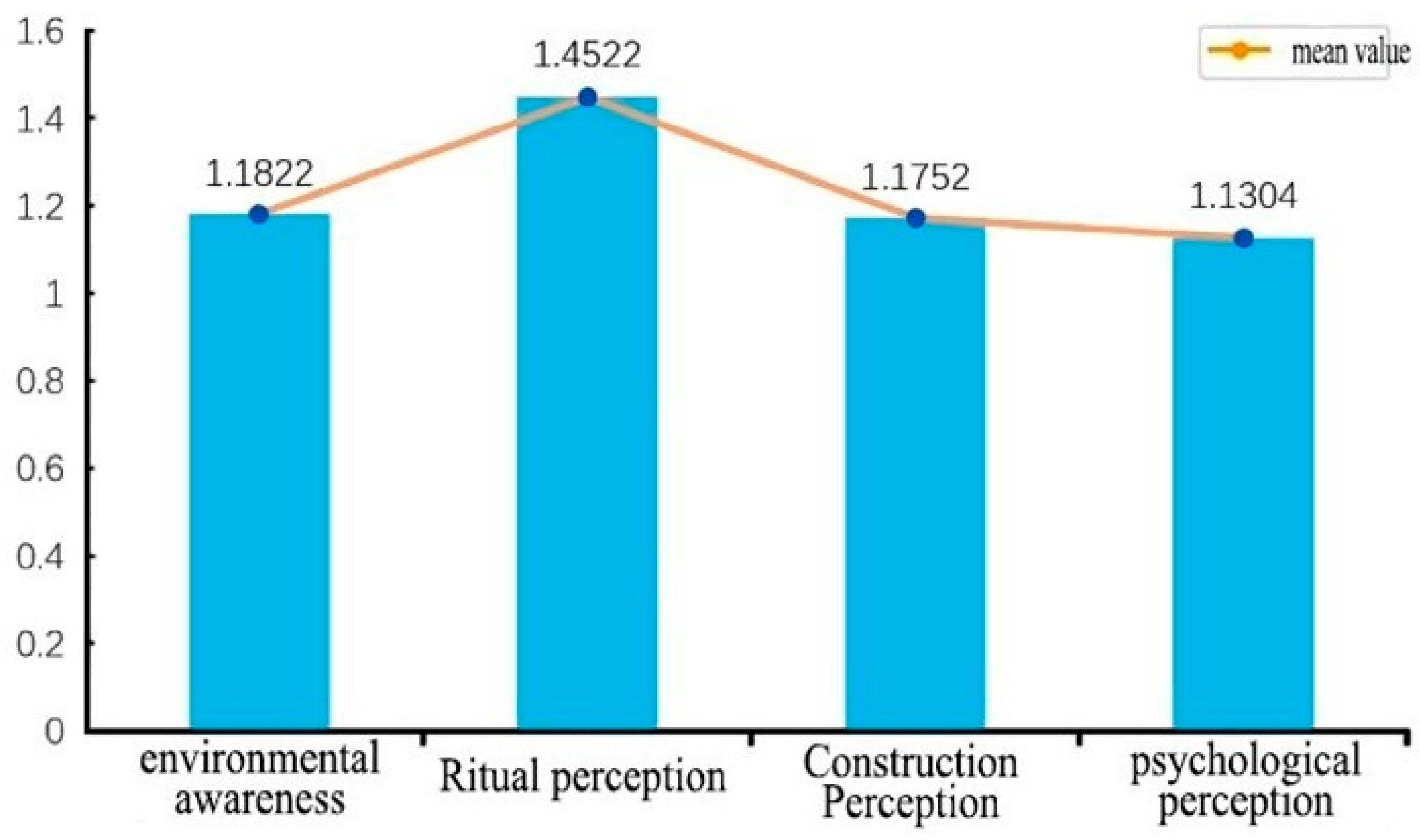
At the dimensional level,
Figure 18 shows that all four perceptual dimensions exhibit positive mean values. Ritual perception achieved the highest score (M = 1.4522), followed by environmental perception (M = 1.1822), construction perception (M = 1.1752), and psychological perception (M = 1.1304). The standard deviations of the four dimensions are all approximately 1.50, indicating moderate variation and a relatively balanced distribution of responses. These results provide a quantitative basis for the following integrated analysis. Overall, the findings suggest that local perceptions are not evenly distributed across different dimensions of the site. Ritual-related meanings are more strongly recognized than physical architectural characteristics, while psychological and environmental perceptions remain closely associated with the continued cultural significance of the landscape (
Figure 18).
5.2. Material Traces and Cultural Recognition
The SD results reveal a clear contrast between the weak perception of architectural form and the stronger recognition of residual material traces. Architectural visibility received the lowest score among the construction-related factors (M = 0.580), indicating that the original form of the Ancient Temple is now difficult to identify. Field observations confirm that most of the temple structure has disappeared, leaving only fragmented remains, ritual objects, stone foundations, and associated landscape features.
In contrast, structural remnants received a substantially higher score (M = 1.660), suggesting that local residents continue to recognize the site through surviving material traces rather than through a complete architectural form. During interviews, one villager noted, “Even though the building is gone, I can still tell where the main altar and incense burner were; these traces remind me of the ceremonies we performed every year.” Other respondents similarly emphasized that ancient trees, stone foundations, and scattered ritual objects serve as important visual and cultural reference points. This helps explain why perceptions of residual structures were significantly stronger than perceptions of overall architectural visibility.
The relatively low scores for circulation routes (M = 0.860) and supporting facilities (M = 0.780) are consistent with field observations of vegetation overgrowth and limited infrastructure. As one participant explained, “The path is hard to follow for outsiders, but we know the way by the stones and the trees. That is why we can still perform rituals here even if the building is ruined.” This finding suggests that cultural recognition is maintained not only through visible material remains but also through ritual practice, collective memory, and embodied spatial knowledge. The results therefore indicate that the cultural significance of the Ancient Temple persists despite the substantial loss of its architectural fabric.
5.3. Ritual Paths and Local Knowledge
Ritual pathways received the highest SD score among all perceptual factors (M = 2.020), while ritual participation also achieved a relatively high score (M = 1.420). Field investigations indicate that these pathways are informal, partially overgrown, and lack clear physical markers. Nevertheless, villagers consistently described their ability to navigate the routes through long-term familiarity with specific landscape features. As one interviewee explained, “I always follow the old trees and stones. Each turn has a story from my grandfather; it tells me where to stop and offer prayers.” Such accounts suggest that the pathways are not recognized primarily through their physical condition but through embodied knowledge, ritual practice, and intergenerational memory, which helps explain their high SD scores.
Compared with the more formal pilgrimage route leading to the Gunv Temple, the pathways associated with the Ancient Temple remain less structured in physical terms but are deeply embedded in local ritual activities and collective memory. The combined evidence from SD analysis, field observations, and oral history materials indicates that ritual pathways constitute an important medium through which cultural meanings are transmitted and reproduced. These findings suggest that ritual continuity plays a central role in sustaining the cultural significance of the Ancient Temple as an implicit cultural landscape.
5.4. Memory, Identity, and Perceptual Tension
The psychological dimension exhibits a more complex pattern. Cultural continuity received a relatively high score (M = 1.570), while memorability also remained positive (M = 1.230), indicating that the Ancient Temple continues to occupy an important place in local memory. In contrast, satisfaction (M = 0.750) and identifiability (M = 0.970) received comparatively lower scores, suggesting that residents recognize the cultural significance of the site while simultaneously perceiving its deteriorated physical condition and limited maintenance.
This contrast is supported by both field observations and oral history accounts. Ritual objects such as incense traces, bowls, offerings, and ceremonial utensils indicate that ritual activities continue at the site despite the decline of its physical environment. Oral histories further reveal a process of functional transformation, through which the site evolved from a Buddhist temple during the Republican period to a village school and later to a ruin associated with local worship and collective memory. Rather than diminishing its significance, these successive functions have contributed additional layers of meaning to local perceptions of place.
The integrated evidence demonstrates that the Ancient Temple is not perceived through a single dimension. Instead, its significance is continuously sustained through the interaction of weakened material remains, ongoing ritual practices, and collective memory. The SD results reveal differences in the strength of individual perceptual dimensions; field investigations explain the material conditions underlying these patterns; and oral history accounts clarify why a site with limited physical preservation continues to maintain strong cultural significance. Together, these findings illustrate how implicit cultural landscapes can persist and remain meaningful even after substantial loss of their material fabric.
5.5. Synthesis of Mixed-Methods Findings
The combined analysis of SD data, field investigations, and oral history materials reveals three key findings. First, the decline of architectural visibility does not necessarily correspond to a decline in cultural significance. Although the physical form of the Ancient Temple is only weakly perceived, residual material traces and remembered locations continue to support local recognition and spatial identification. Second, ritual pathways represent a critical component of the implicit cultural landscape because they connect spatial movement, ritual practice, and collective memory. Third, local identity is maintained through the dynamic interaction between material deterioration and cultural continuity.
These findings highlight the value of integrating quantitative and qualitative methods in the study of implicit cultural landscapes. SD analysis provides measurable evidence of perceptual differences, field investigations document the material and environmental conditions of the site, and oral history materials reveal the cultural meanings underlying local perceptions. Together, these approaches demonstrate that implicit cultural landscapes are sustained not solely through visible remains but through the continuing interaction of material traces, ritual practices, and collective memory. This integrated understanding provides an important foundation for the following discussion of cultural landscape conservation and regeneration strategies.
5.6. Analysis of Four Perceptual Dimensions
A cross-dimensional comparison further reveals that the four perceptual dimensions exhibit distinct yet interconnected interpretive patterns. Environmental perception is primarily associated with the physical conditions documented through field investigation, including limited accessibility, vegetation overgrowth, and inadequate infrastructure, which constrain direct spatial experience. Construction perception is strongly affected by the loss of architectural form but remains partially sustained through residual material anchors, such as stone foundations and ritual objects identified during field surveys and oral history interviews. In contrast, ritual perception is reinforced by both SD results and ethnographic evidence, demonstrating a high degree of consistency between quantitative perceptions and lived practices. This is particularly evident in the embodied knowledge associated with ritual pathways and recurring ceremonial activities. Psychological perception, while displaying greater variation in SD scores, is largely shaped by oral history narratives concerning transformation, loss, and continuity. These narratives reveal temporal layers of memory that cannot be fully understood through material evidence alone. Taken together, these differences indicate that local perceptions are not evenly distributed across dimensions but are co-produced through the interaction of material visibility, embodied practice, and collective memory. The four dimensions therefore constitute a multi-layered interpretive structure through which the implicit cultural landscape is perceived, experienced, and sustained.
6. Discussion
The integrated analysis of the Ancient Temple site in Baiya City demonstrates that implicit cultural landscapes persist beyond visible material structures through the interaction of residual physical traces, ritual practices, collective memory, and psychological identification. Ritual pathways and seasonal ceremonies maintain strong cultural significance despite structural degradation, highlighting the resilience of local cultural systems.
The preceding analysis suggests that the Baiya case extends beyond a local example of spatial perception and provides a valuable context for understanding how implicit cultural landscapes are sustained through the interaction of ritual practices, collective memory, and community participation.
The Baiya case illustrates how indigenous spatial orders and informal ritual routes continue to structure cultural landscapes. Although these pathways are not formally recognized within planning frameworks, they function as important carriers of collective memory, social cohesion, and cultural continuity. The interaction between material traces and ritual practices further reveals a mechanism through which cultural meanings are maintained and reproduced over time, suggesting that implicit cultural landscapes cannot be fully understood through the analysis of physical remains alone. Moreover, the persistence of psychological identification with the site highlights the importance of emotional attachment and community participation in sustaining heritage values and reinforcing long-term cultural continuity [
45,
46].
The mixed-method approach adopted in this study, combining field investigation, oral history interviews, and SD-based perception analysis, provides insights that would be difficult to obtain through any single method. Quantitative perception data reveal patterns of recognition and valuation across different spatial dimensions, while qualitative observations and oral narratives help explain the cultural and social mechanisms underlying these patterns. The integration of these methods enables a more comprehensive understanding of how material traces, ritual practices, collective memory, and local perceptions interact in the formation and persistence of implicit cultural landscapes. As such, this approach demonstrates the value of combining multiple forms of evidence to capture the dynamic relationships between the tangible and intangible dimensions of cultural landscapes.
These findings have important implications for heritage conservation and landscape regeneration. The results suggest that conservation strategies should extend beyond the preservation of physical remains to encompass ritual practices, collective memory, and community participation. In the case of implicit cultural landscapes, documenting ritual pathways, supporting local ceremonial activities, and incorporating community narratives into interpretation, planning, and design strategies may contribute to the continuity of local cultural traditions and strengthen the resilience of cultural landscapes. Such approaches can help ensure that heritage conservation addresses not only material authenticity but also the social and cultural processes through which landscape meanings are maintained and reproduced.
Compared with previous studies on cultural landscapes and spatial perception, this research both confirms and extends existing understandings. Consistent with UNESCO cultural landscape perspectives and theories of spatial perception, the findings indicate that cultural landscapes emerge through the interaction of environmental settings, cultural practices, and human experience. This supports existing arguments that landscape meaning is not solely derived from physical form but is continuously shaped through social and cultural processes. However, unlike studies that primarily emphasize visible heritage features, spatial morphology, or static landscape elements, this research highlights the persistence of implicit cultural landscapes sustained through ritual practices, collective memory, and community participation. The findings demonstrate that cultural significance can remain strong even when architectural forms have become fragmented or partially lost. Furthermore, in contrast to phenomenological approaches that focus primarily on experiential interpretation, this study combines SD-based perception measurement with field investigation and oral history analysis, providing a more systematic understanding of the relationships among lived experience, spatial perception, and cultural meaning. A key contribution of this research is the identification of ritual pathways as hybrid cultural structures that simultaneously function as carriers of collective memory, guides for spatial practice, and frameworks for cognitive orientation. This finding extends existing interpretations of cultural landscapes toward a triadic framework linking material traces, embodied practices, and perceptual cognition.
By situating the Baiya case within broader national and international discussions on implicit cultural landscapes, ritual practices, and collective memory, this study contributes to a deeper understanding of how cultural meanings are maintained and reproduced through the interaction of material traces, embodied practices, and local perceptions. The findings demonstrate the value of integrating field investigation, oral history analysis, and perception-based assessment to interpret cultural landscapes whose material forms have become fragmented or partially lost. Future research could apply this analytical framework to other vernacular settlements and heritage contexts to examine how implicit cultural landscapes respond to processes of modernization, tourism development, and rural revitalization. Comparative studies across different cultural and geographical settings may further clarify the mechanisms through which ritual practices, collective memory, and local perceptions contribute to the continuity and transformation of cultural landscapes, thereby providing additional insights for context-sensitive heritage conservation and management.
7. Conclusions
This study examines the Ancient Temple ruins in Baiya City as a case of an implicit cultural landscape and explores how cultural significance can be maintained despite the loss of material form. The findings indicate that ritual pathways, seasonal practices, collective memory, and emotional attachment continue to sustain the cultural meaning of the site, even though its architectural remains have become fragmented and difficult to identify. The results further reveal that ritual-related perceptions are stronger than perceptions of architectural visibility and physical conditions, demonstrating a divergence between material preservation and perceived cultural significance.
This research contributes to cultural landscape studies by extending attention from visible heritage features to socially reproduced and perceived spaces shaped through ritual practices, collective memory, and local perceptions. Methodologically, the integration of field investigation, oral history analysis, and Semantic Differential (SD) assessment provides a systematic framework for identifying and interpreting implicit cultural landscapes in vernacular settlements. The findings also support a triadic understanding of cultural landscape persistence based on the interaction among material traces, embodied practices, and perceptual cognition.
Several limitations should be acknowledged. The research is based on a single case study and a predominantly local sample, which may limit the broader applicability of the findings. Future studies could employ comparative multi-site approaches, larger and more diverse samples, and longitudinal investigations to examine how implicit cultural landscapes evolve under processes of modernization, tourism development, and rural revitalization.
The regeneration of implicit cultural landscapes may also face challenges, including tourism pressure, the formalization of ritual practices, the exclusion of local communities, and the commercialization of cultural traditions. Conservation strategies should therefore prioritize the continuity of living cultural practices and community participation rather than focusing solely on tourism-oriented reconstruction. In this regard, the findings support community-based approaches to heritage conservation and cultural transmission, contributing to the objectives of SDG 11 (Sustainable Cities and Communities), SDG 4 (Quality Education), and SDG 17 (Partnerships for the Goals).




 ,
,