1. Introduction
The accelerating pace of modern life has contributed to the rising prevalence of chronic diseases, posing a major challenge to public health worldwide. Walking and running, as common and accessible forms of physical activity, have been widely recognized for their effectiveness in reducing the risk of hypertension, diabetes, and other chronic conditions, thereby promoting overall health and well-being [
1]. Urban parks serve as essential venues for daily recreation and exercise, and their spatial features have become a focal point of interdisciplinary research spanning landscape architecture, public health, and urban environmental studies [
2].
Existing studies have examined the relationship between park environments and physical activity from multiple perspectives, including park accessibility [
3], facility provision [
4], and natural elements [
5]. However, the effects of these factors on physical activity are neither constant nor isolated; rather, they are dynamically shaped by spatial types and spatiotemporal variation. Recent advances in spatiotemporal research have further underscored the importance of distinguishing between spatial types and time periods. For example, Chen et al. [
6] found that linear pathways are more conducive to sustained running, whereas open plazas tend to attract short-duration, high-density group use. Using geographically and temporally weighted regression, Tao et al. [
7] identified distinct morning and evening peaks and midday troughs in park-based walking and running activities, and further revealed time-sensitive variations in the behavioral effects of spatial attributes. Similarly, Yang [
8], in a study conducted in Detroit, observed that highly connected pathways significantly promoted running activity, particularly on summer evenings. Together, these findings suggest that identifying what to intervene in and when to intervene is both theoretically and practically important for enhancing the health-promoting functions of urban parks.
Despite the growing body of related research, three key gaps remain in the existing literature. First, many studies have treated parks as holistic spatial units or have focused primarily on external park accessibility and neighborhood-scale built environments, with insufficient attention to micro-scale spatial units within parks [
7]. In fact, pathways and plazas differ substantially in spatial form, functional orientation, and behavioral affordances: pathways typically support continuous movement, whereas plazas more often accommodate gathering, resting, and short-duration group activities [
9]. Failing to distinguish between spatial types may therefore obscure the differentiated mechanisms through which spatial features influence walking and running activities. Second, although increasing attention has been paid to spatiotemporal dynamics, such studies remain limited. Most existing research has adopted a static perspective and has rarely examined behavioral variations across different periods of the day [
10]. The same spatial feature may exert different effects as daylight, thermal comfort, and perceived safety change throughout the day. Third, many studies rely on self-reported questionnaires, short-term observations, or single activity-count indicators [
11], making it difficult to fully capture the long-term spatiotemporal fluctuations of walking and running activities. Such approaches also limit the ability to determine whether spatial features attract more users or promote higher intensity physical activity.
To address these gaps, we take micro-scale spatial units as the analytical basis, distinguish between pathways and plazas, and incorporate intra-day temporal heterogeneity to reveal how spatial features differentially influence walking and running activities across time periods. The study aims to examine the dynamic mechanisms through which urban park spatial features affect physical activity density and intensity.
Using three representative urban parks in Shanghai—Xujiahui Park, Fuxing Park, and Lujiazui Center Green—as study sites, this research selected 30 micro-scale spatial units, including pathways and plazas. Based on long-term, high-frequency field observations from 2021 to 2023, it analyzes the spatiotemporal effects of urban park spatial features on walking and running activities. Unlike studies that rely solely on user counts or visit frequency, we adopt two complementary indicators: Daily W&RA Density, which reflects the concentration of walking and running activities within a given spatial unit, and Daily per capita W&RA METs, which captures the average activity intensity of users. By examining both activity density and activity intensity, we provide a more nuanced understanding of whether spatial features primarily influence the attraction of users to engage in physical activity or the changes in activity intensity.
This study is organized around three interrelated objectives. First, it compares the distribution patterns of Daily W&RA density and Daily per capita W&RA METs between pathways and plazas. This comparison is not intended simply to confirm expected functional differences; rather, it serves as an analytical baseline for determining whether spatial-type heterogeneity should be explicitly incorporated into subsequent models. Second, the study identifies spatial features that exert either consistent or differentiated effects on walking and running activities across the two space types, thereby clarifying whether health-oriented design strategies should be broadly applicable or tailored to specific space types. Third, it examines how the effects of spatial attributes vary across five intra-day periods, revealing the temporal conditions under which specific park spatial features promote or inhibit walking and running activities.
By adopting a spatiotemporal perspective, we contribute to a more nuanced understanding of how micro-scale spatial configurations in urban parks support physical activity. The findings are expected to inform health-oriented park design and refined management strategies, thereby offering evidence-based pathways to promote population-level physical activity and public health.
2. Materials and Methods
To address the research questions, we first selected ten sampling units in each of three comprehensive urban parks—Xu Jiahui Park, Fu Xing Park, and Lujiazui Central Green Space—yielding 30 units in total. For each unit, data on walking and running activities and corresponding spatial attributes were collected through systematic field observation. Descriptive statistics were then compiled to compare activity density and intensity between plaza and pathway units. Second, correlation tests were conducted, followed by the construction of separate OLS models for plaza and pathway units to identify spatial features that consistently or divergently influence walking and running levels in the two space types. Finally, time-specific OLS models were developed for five daily periods to examine how the effects of spatial attributes vary throughout the day.
2.1. Study Parks and Sampling Units
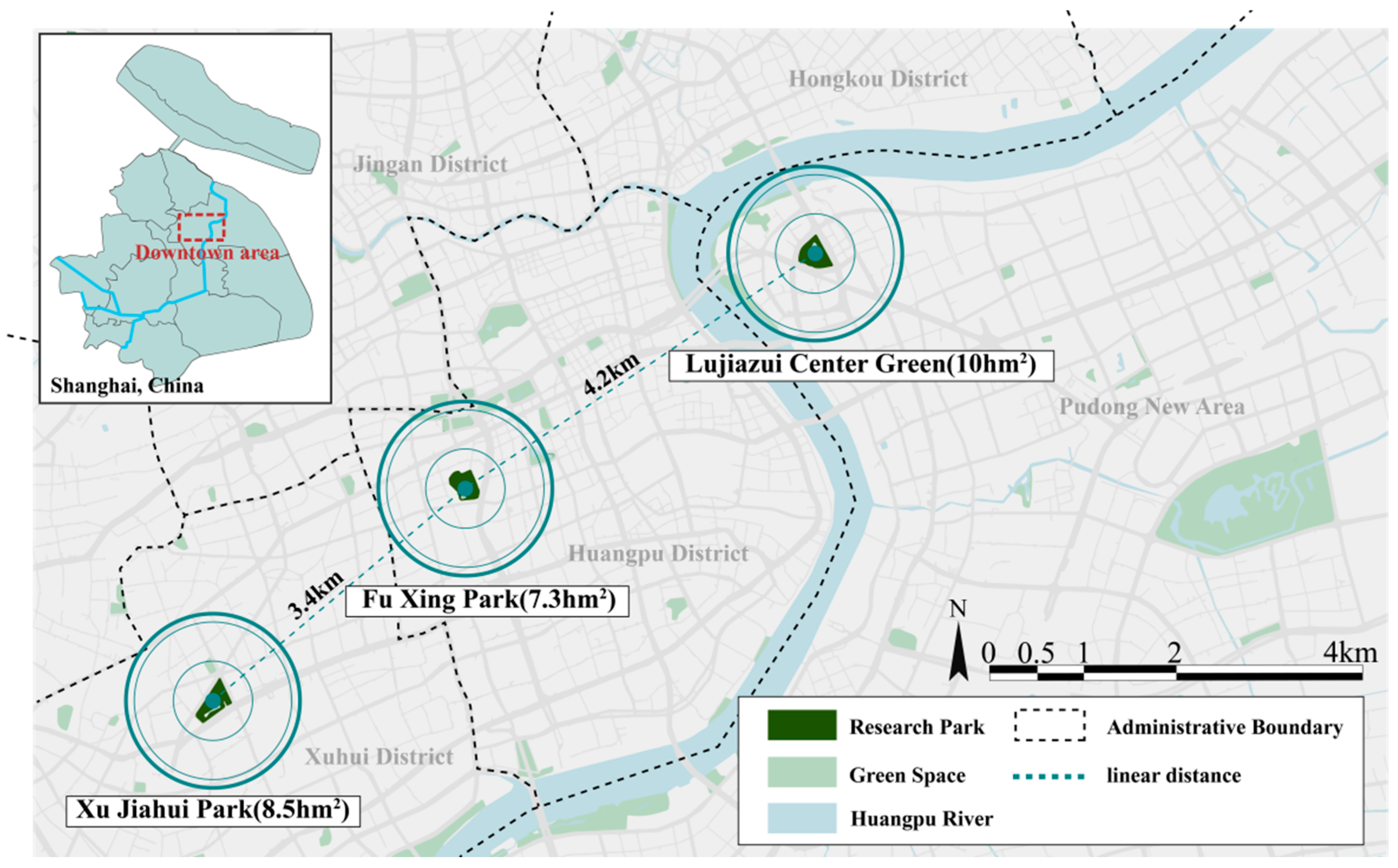
The study sites comprise three comprehensive urban parks located within Shanghai’s Inner Ring Road: Xu Jiahui Park, Fu Xing Park, and Lujiazui Central Green Space (
Figure 1). All three parks lie in the city’s central districts, share comparable sizes, and sustain high levels of recreational use, providing sufficient area and diversity of settings to support a wide range of walking and running activities. Within each park, ten units—representing both pathway and plaza environments—were delineated for detailed observation and spatial measurement.
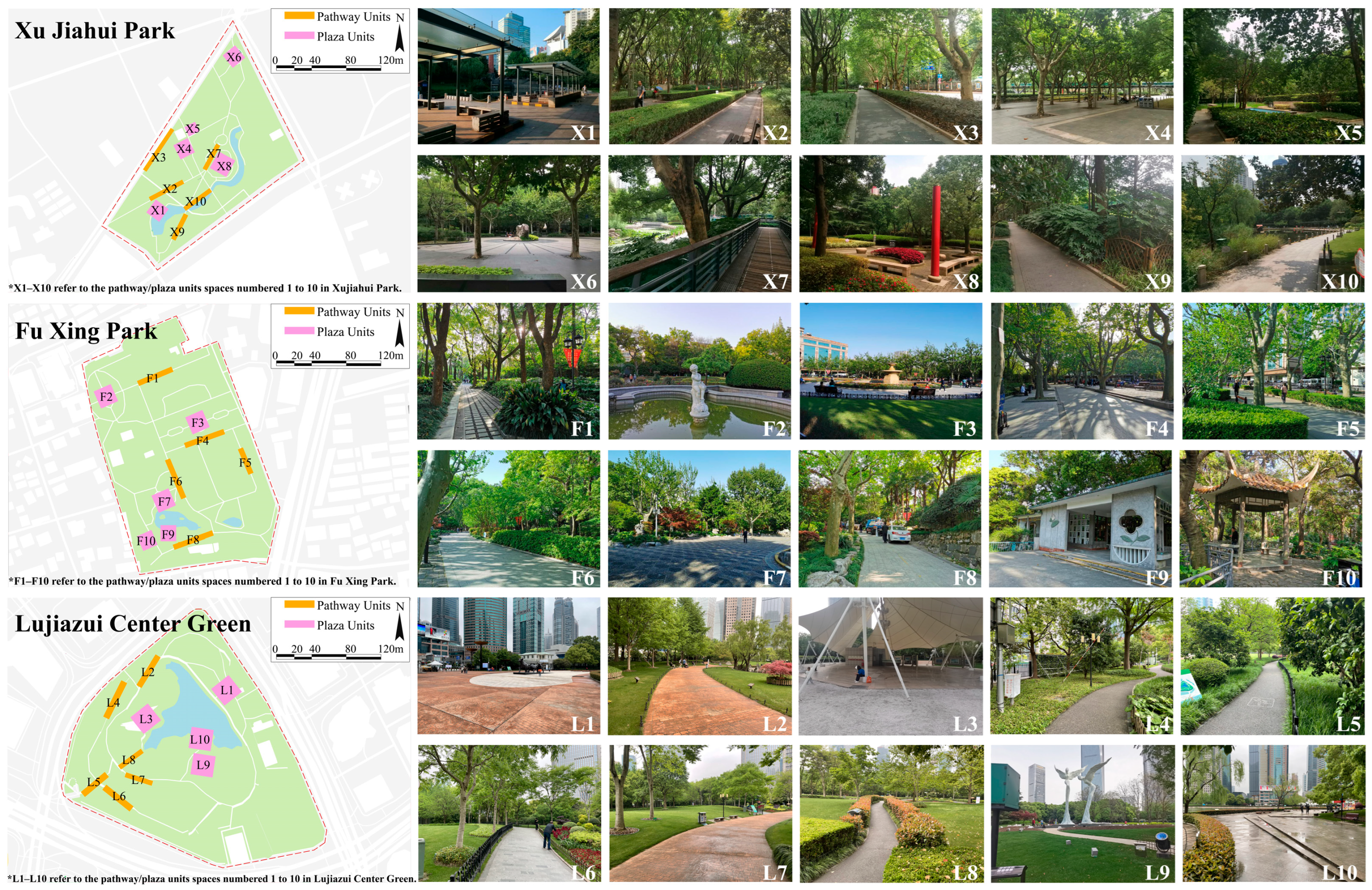
A total of 30 spatial units suitable for walking and running activities were selected across the three parks through a preliminary site survey. These included 16 pathway units and 14 plaza units. Pathway units were required to have a smooth, continuous linear form with a minimum length of 50 m, while plaza units were characterized by flat, open spaces with a minimum area of 50 square meters. Both types of units excluded any locations with outdoor steps, staircases, or significant elevation changes that could hinder walking or running. Additionally, the units were spatially distributed throughout each park to ensure representativeness. Example photos of the selected units are shown in
Figure 2.
2.2. Data Collection
2.2.1. Spatial Feature Data Collection in Urban Parks
Previous studies suggest that walking and running activities are influenced by factors related to spatial organization features [
12], spatial place features [
13], and spatial perception features [
14]. Accordingly, we selected a range of spatial indicators across these three dimensions that have been empirically linked to walking and running, in order to comprehensively examine their potential effects. The selected indicators are summarized in
Table 1.
Spatial organization features included integration value, selectivity, control and connection value, and the time required to reach the nearest entrance. The four space syntax indicators were calculated in depthmapX (version 0.8.0) using axial maps derived from openstreetmap and verified through field surveys. For each sample unit, the mean value of the segments located within or directly corresponding to the unit was used. The time required to reach the nearest entrance was used as an accessibility indicator. It was calculated based on the shortest walkable route from each sample unit to the nearest accessible park entrance, converted using a walking speed of 1.5 m/s, and further validated through field timing.
Spatial place features included path length, path width, path length-to-width ratio, path type, vegetation coverage ratio, vegetation structure, water proximity, pavement type, and density of seats. Path length and path width were measured using openstreetmap base maps and verified through field surveys. Path type was coded as either straight or curved. Vegetation structure was classified into single-, double-, and triple-layer structures according to the vertical composition of vegetation. The vegetation coverage ratio was calculated as the proportion of vegetated area within each sample unit. Water proximity was coded according to whether the sample unit was adjacent to a water body. Density of seats was calculated as the number of seats per unit area.
Spatial perception features included sky view ratio, green view ratio, density of streetlights, and density of security facilities. The sky view ratio and green view ratio were extracted from photographs of each sample unit using GluonCV-based semantic segmentation. Density of streetlights and density of security facilities were calculated as the number of streetlights and safety-related facilities per unit area, respectively. Security facilities included warning signs, surveillance cameras, and other visible safety-related installations.
2.2.2. Walking and Running Activity Data Collection
From 2021 to 2023, a total of 72 days of on-site observations were conducted. Each month, three days with clear weather (two weekdays and one weekend day) were selected for observations across the 30 units. Using a behavioral annotation method, we recorded the number of participants and the type of walking or running activity within each unit.
To improve comparability across observation days, the same five intra-day periods were used for all observations: 6:00–8:00, 8:00–10:00, 11:00–13:00, 14:00–16:00, and 18:00–20:00. Each sample unit was observed once during each period. Each sample unit was observed for a standardized 8 min period within each time window. This duration was selected to balance behavioral measurement accuracy with fieldwork feasibility. Walking and running activities in urban parks are often highly mobile and transient; therefore, a relatively short and standardized observation period can capture through-movement and short-duration use while reducing the risk of double counting. The 8 min protocol also allowed the research team to complete observations at all sample units within the same park during each predefined two-hour period, thereby ensuring relatively consistent temporal conditions across sample units, dates, and parks. Over the two-year observation period, the research team collected a total of 206,407 raw activity records.
It should be noted that the 30 sample units were repeatedly observed across five intra-day periods over 72 observation days. After aggregation, the daily-scale models included 2160 unit–day observations, whereas the time-period-specific analyses included 10,800 unit–day–period observations. In the spatial-type models, the plaza dataset included up to 1008 unit–day observations, while the pathway dataset included up to 1152 unit–day observations. This repeated-observation structure substantially increased the effective sample size for model estimation and reduced the risk of drawing conclusions based solely on a limited number of spatial units.
2.3. Data Quantification Methods
The walking and running data were processed and categorized into four activity types based on estimated movement speed, regardless of whether individuals were accompanied. The four types—strolling, brisk walking, jogging, and running—and their corresponding MET values were defined according to the 2011 Compendium of Physical Activities (CPA) [
15], as summarized in
Table 2.
To establish a quantitative relationship between urban park spatial features and walking–running activity levels, the observed data were further processed into two indicators: daily walking–running density and daily per capita walking–running metabolic equivalents (METs). The formulas are defined as follows:
2.4. Statistical Analysis
To examine the relationship between urban park spatial features and walking and running activity levels, we employed Ordinary Least Squares (OLS) regression models. The primary objective of this study was to obtain interpretable estimates of the direction and relative strength of associations between specific spatial features and walking and running activity outcomes. Compared with black-box machine learning models, OLS provides clearer coefficient-based evidence that can be more readily translated into planning and design implications. In addition, this study focuses on repeated observations of a fixed set of micro-scale spatial units. Because the number of spatial units is relatively limited, highly localized models such as geographically weighted regression may produce less stable estimates.
To reduce model specification bias, predictor selection was conducted in three stages. First, candidate variables were identified based on theoretical relevance and prior empirical evidence. Second, Pearson correlation analysis and nonparametric tests were used as preliminary screening tools. Variables with weak theoretical relevance and no statistically significant association with either outcome variable were excluded. Third, stepwise regression based on the Akaike information criterion (AIC) was used to assess model parsimony. Variables were retained in the final models if they had clear theoretical relevance, showed statistically significant associations with the outcome variables, and did not introduce sever multicollinearity. When two predictors were highly correlated, the variable with stronger theoretical interpretability and better model performance was prioritized. Separate OLS models were then developed by space type and time period, with standardized coefficients estimated to evaluate the relative influence of each spatial feature on activity density and intensity.
To improve model fit and satisfy normality assumptions, square root transformations were applied to both dependent variables. As such, the final models used the square roots of Daily W&RA density and Daily per capita W&RA METs as outcome variables. Model diagnostics were conducted to assess the validity of the OLS estimates. Residual normality was evaluated using Q–Q units and the Shapiro–Wilk test, and the results indicated that all models satisfied the assumption of normally distributed residuals. Multicollinearity was assessed using the variance inflation factor (VIF), with all retained variables showing VIF values below 7.5. Given the spatial nature of the data, Global Moran’s I was further calculated for the residuals of the main models to test for spatial autocorrelation. Because each sample unit was repeatedly observed across multiple dates and time periods, model residuals were first aggregated by sample unit to obtain the mean residual for each unit. A row-standardized four-nearest-neighbor spatial weights matrix was then constructed based on the centroid coordinates of the sample units. The statistical significance of Moran’s I was assessed using 9999 random permutations. The diagnostic results showed no significant spatial autocorrelation in the residuals of any model. The relevant diagnostic statistics are reported in
Table S1 in the Supplementary Material.
3. Results
3.1. Descriptive Statistics
Table 3 summarizes the descriptive statistics for Daily W&RA density and Daily per capita W&RA METs in pathway and plaza spaces. Overall, the mean values of both indicators were higher in pathway spaces than in plaza spaces, indicating a higher average level of walking and running activity in pathways. By contrast, plaza spaces showed greater variability, including both zero-activity observations and peak values exceeding those observed in pathway spaces.
Specifically, both Daily W&RA density and Daily per capita W&RA METs in plaza spaces included observations with a minimum value of zero, whereas no zero values were observed in pathway spaces. At the same time, the maximum values of both indicators were higher in plaza spaces than in pathway spaces, despite their lower mean values. These results suggest that pathway and plaza spaces differ not only in average activity levels but also in the range of activity variation and peak activity intensity. Therefore, separate models were subsequently developed for pathway and plaza spaces to identify how spatial features are associated with walking and running activities within each spatial type.
3.2. OLS Models for Plazas and Pathways
Table 4 and
Table 5 report the OLS model results for plaza and pathway spaces, respectively. For Daily W&RA density, both spatial-type models identified several common predictors. The density of security facilities and single-layer vegetation structure were positively associated with activity density in both plaza and pathway spaces. Pavement type also showed effects in both spatial types, with several hard pavement types associated with higher activity density. At the same time, several variables showed clear spatial-type differences. In the plaza model, connection value, density of seats, and density of security facilities exhibited strong positive associations, whereas selectivity, path length, green view ratio, and rubber pavement showed negative associations. In the pathway model, path length, vegetation coverage ratio, water proximity, density of security facilities, and several pavement type categories were positively associated with activity density, whereas density of seats and triple-layer vegetation structure were negatively associated. The standardized coefficients indicate that density of security facilities, connection value, density of seats, and pavement type were relatively important predictors in the plaza density model, while density of security facilities, pavement type, vegetation coverage ratio, and water proximity had greater relative importance in the pathway density model.
For Daily per capita W&RA METs, the models identified fewer predictors than those for activity density. In plaza spaces, selectivity and triple-layer vegetation structure were negatively associated with activity intensity, whereas brick pavement showed a positive association. In pathway spaces, control value, vegetation coverage ratio, brick pavement, and density of security facilities were positively associated with activity intensity, whereas water proximity, single- and triple-layer vegetation structure, and several pavement type categories showed negative associations. Compared with the density models, the METs models included fewer significant predictors and showed more concentrated directional effects.
Overall, the spatial-type models indicate that Daily W&RA density and Daily per capita W&RA METs do not respond to spatial features in the same way. The activity density models included a broader set of significant predictors, whereas the activity intensity models showed stronger variable selectivity. The differentiated patterns across spatial types further suggest that pathway and plaza spaces should be analyzed separately.
3.3. OLS Models for Different Time Periods
Table 6 and
Table 7 report the OLS model results for the five intra-day periods. Overall, the explanatory power of the five Daily W&RA density models was consistently higher than that of the corresponding Daily per capita W&RA METs models. The adjusted R
2 values of the density models remained relatively high, whereas those of the METs models were lower, indicating that spatial features explained activity density more effectively than activity intensity.
For Daily W&RA density, connection value, green view ratio, density of streetlights, density of security facilities, and single-layer vegetation structure showed positive associations across all five periods. Among these variables, connection value, density of streetlights, and density of security facilities had relatively large standardized coefficients in multiple periods, suggesting high relative importance. By contrast, selectivity, the time required to reach the nearest entrance, path length, vegetation coverage ratio, and rubber pavement were negatively associated with activity density across all five periods.
Some variables exhibited time-period-specific effects. Sample-unit area, control value, and density of seats were significant mainly during 11:00–13:00, 14:00–16:00, and 18:00–20:00. Path width was significant primarily during the first four periods. Sky view ratio showed a positive association during 6:00–8:00 but negative associations during 11:00–13:00 and 14:00–16:00. Water proximity and several pavement type categories also showed differentiated effects across time periods.
For Daily per capita W&RA METs, connection value, path length, sky view ratio, green view ratio, density of security facilities, brick pavement, and asphalt pavement were positively associated with activity intensity in multiple periods. Notably, sky view ratio showed a positive association across all five periods and had relatively large standardized coefficients in several models. By contrast, control value, the time required to reach the nearest entrance, curved pathways, single-layer vegetation structure, water proximity, gravel pavement, and rubber pavement were negatively associated with activity intensity in multiple periods.
Several variables also showed temporal variation in their effects. Density of streetlights was positively associated with activity intensity in multiple periods except 8:00–10:00. Path width was significant only during 6:00–8:00 and 18:00–20:00. Sample-unit area, density of seats, and vegetation coverage ratio were significant mainly during 8:00–10:00. Overall, the time-specific models indicate that some spatial features exerted stable effects throughout the day, whereas others were significant only during particular periods.
Together, these results document strong spatial-type differences and pronounced time-of-day heterogeneity in how urban park features shape both the density and intensity of walking and running activities.
4. Discussion
4.1. Differences in Walking and Running Activities Between Plaza and Pathway Spaces
This study identified statistically significant differences in both Daily W&RA density and Daily per capita W&RA METs between plaza and pathway spaces. In terms of minimum values, both indicators recorded zeros in plazas but not in pathways. This contrast likely reflects functional differences between the two space types. Plazas often serve as activity destinations, exhibiting strong temporal specificity. For example, they may host high-intensity group exercises in the early morning but remain underutilized at midday or late at night [
16]. In contrast, pathways serve as linear connectors within parks, supporting continuous use throughout the day—even during low-traffic periods—for purposes such as strolling, brisk walking, or commuting. This helps explain the absence of zero values in pathway observations.
Regarding maximum values, plazas exhibited higher peaks in both activity density and intensity, likely due to their spatial configuration, which is more conducive to collective movement and gathering. Prior research suggests that open planar layouts and ample surface area can accommodate more users and more intensive activity patterns [
17], whereas the linear and often narrower geometry of pathways may constrain their capacity to support large crowds.
When comparing mean values, however, pathways showed higher average Daily W&RA density and per capita W&RA METs than plazas. This suggests a sustained behavioral advantage stemming from the spatial form of pathways. Two mechanisms may account for this pattern: (1) the visual continuity of linear corridors helps maintain pace and direction, creating a perceptual cue that reinforces movement behavior [
18]; and (2) higher integration values improve accessibility and route appeal, increasing the likelihood of their selection for walking or running activities [
19]. Although plazas have the potential to support more intense or large-scale activities, their multifunctionality may introduce competing uses and spatial conflicts. As noted by Alwah et al. [
20], multifunctional open spaces often experience conflict between resting and active users, potentially reducing their effectiveness in supporting sustained physical activity.
It should be noted that these interpretations do not imply that spatial type itself directly determines walking and running activities. Differences between spatial types may also be shaped by sample-unit location, user composition, activity purpose, and intra-day management arrangements. For example, peak activity levels in plazas may be associated with group exercise, square dancing, or community-organized activities, whereas the more stable use of pathways may be related to commuting-like through-movement, routine strolling, and habitual running. Therefore, the findings of this study should be understood as evidence of associations between the two spatial forms and walking and running activities, rather than as causal relationships in a strict sense.
4.2. Spatial Features Influencing Walking and Running in Plazas and Pathways
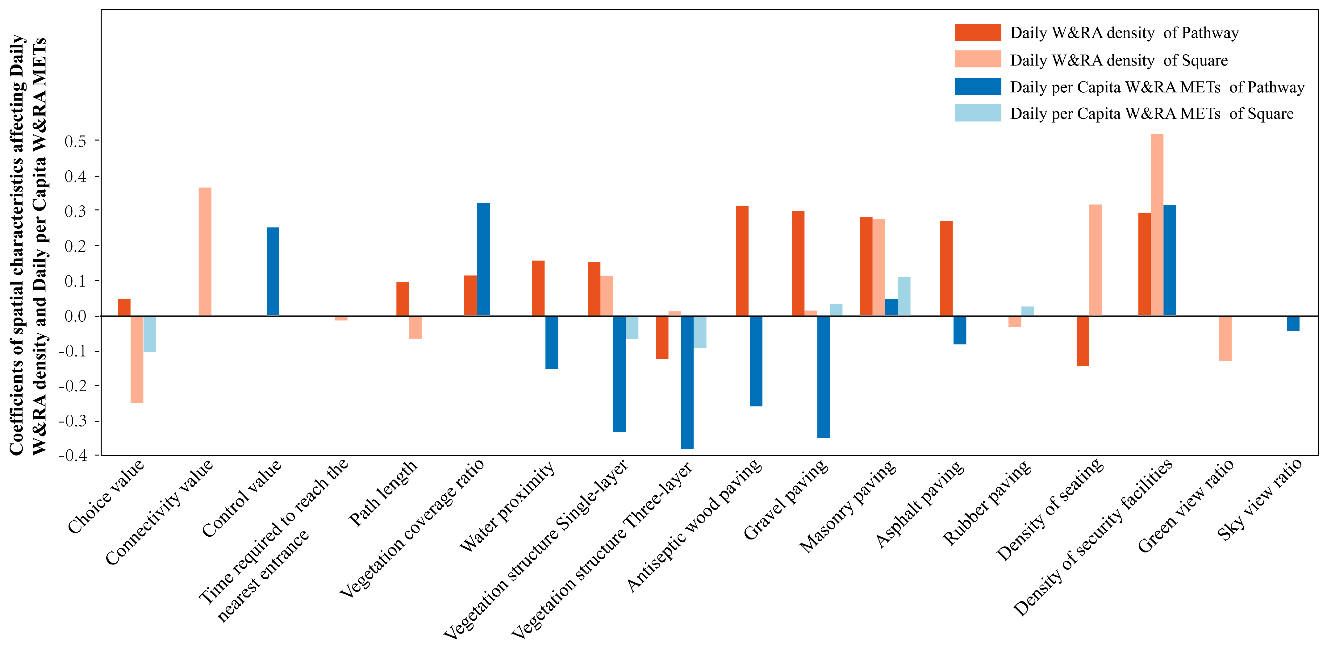
Regression models further revealed that the spatial determinants of walking and running varied between plaza and pathway spaces (
Figure 3). In plaza environments, Daily W&RA density was positively associated with connection value, density of seats, density of security facilities, single-layer and triple-layer vegetation structures (vs. double-layer), and gravel and stone pavement (vs. concrete). Negative associations were observed with selectivity, main path length, green view ratio, and rubber pavement. For activity intensity, only stone pavement exerted a positive influence, while selectivity and triple-layer vegetation were associated with reduced per capita METs.
In pathway environments, Daily W&RA density was positively influenced by main path length, vegetation coverage ratio, density of security facilities, water proximity, single-layer vegetation, and the use of antiseptic wood, gravel, stone, and asphalt pavements (vs. concrete). Negative effects were found for density of seats and triple-layer vegetation. As for Daily per capita W&RA METs, positive predictors included control value, vegetation coverage, stone pavements, and security facility density, while negative predictors included water proximity, single-layer and triple-layer vegetation, and antiseptic wood, gravel, and asphalt pavements.
These findings underscore both contextual variability and partial consistency in how spatial features function across environments. For example, stone pavements consistently promoted higher activity intensity in both space types, while triple-layer vegetation universally reduced it. In contrast, features such as seat density and main path length exhibited directional reversals, emphasizing the need for spatial-type-specific design strategies when optimizing urban parks for physical activity.
4.2.1. Common Features: Universal Influences Across Spatial Types
Among the spatial features influencing walking and running activities, density of security facilities, single-layer vegetation structure, gravel pavement, and brick pavement consistently promote Daily W&RA density across both spatial types. The positive effect of density of security facilities suggests that perceived safety may promote physical activity. Monitoring devices and emergency signage reduce users’ concerns about risks, thereby extending activity duration [
21,
22]. This aligns well with the “safety” dimension in Ma et al.’s framework of physical activity influencing factors [
23], indicating that perceived safety is a fundamental requirement transcending spatial types. Single-layer vegetation fosters Daily W&RA density by providing open sightlines and permeability, enhancing users’ environmental control [
24]. By contrast, triple-layer vegetation structure was negatively associated with activity intensity in both spatial types. This may be because dense canopy enclosure obstructs sightlines and increases perceived insecurity, thereby reducing activity intensity [
25]. Brick pavement positively influences both activity density and intensity in plazas and paths, likely due to its rough surface offering adequate friction, meeting users’ needs for stable footing. Deleen et al. and Ettema’s studies highlight ground surface stability and comfort as key factors in increasing running frequency and route attractiveness [
26,
27].
Adequate security facilities, a simple vegetation structure, and stable, comfortable pavement reflect users’ strong concern for spatial safety and comfort. Thus, regardless of spatial type, safety and comfort should be prioritized in design.
4.2.2. Distinct Features: Functional Modulation Across Spatial Types
Seat density and triple-layer vegetation structure positively influence Daily W&RA density in plazas but have negative effects in pathways. The conflicting impact of seat density reflects the dynamic compatibility between facilities and spatial functions. Plazas, as multifunctional spaces, require a balance between activity and rest, where ample seating supports this dynamic equilibrium [
28]. Excessive seating in linear pathway spaces, however, may disrupt spatial continuity and interfere with movement rhythm. Similarly, triple-layer vegetation in plazas alleviates exercise fatigue by providing shade and visual appeal, whereas in pathways it creates oppressive sightlines, impairing the exercise experience. This finding concurs with previous research showing that dense vegetation along pathways may increase canopy enclosure, obstruct sightlines, and potentially reduce users’ willingness to engage in physical activity [
29]. Conversely, abundant vegetation in plazas may be more likely to encourage users to engage in activities and rest [
24]. Therefore, vegetation should not be understood simply as “the more, the better.” From the perspectives of ecosystem planning and ecological carrying capacity, vegetation structure is not only an environmental factor influencing activity behavior but also an indicator of ecosystem service provision and ecological carrying capacity in urban parks [
30]. Specifically, triple-layer vegetation may enhance ecological services such as shading, cooling, habitat support, and landscape restoration. However, if it obstructs sightlines and reduces perceived safety, it may inhibit continuous walking and running activities in pathway spaces. Balancing shading, cooling, habitat support, visual permeability, and activity safety is therefore a critical issue for health-oriented park design.
Main path length negatively affects Daily W&RA density in plazas but positively affects it in pathways. The negative impact in plazas suggests that overly long main paths fragment spatial integrity, weakening the plaza’s role as an activity destination. In contrast, as primary carriers of walking and running activities, longer main pathways in paths support continuity, visually extending routes and encouraging sustained activity [
31].
Besides the spatial features showing differential influence across spatial types, some features affect only one type. In plazas, connection value promotes Daily W&RA density by enhancing accessibility and attracting users. High connection values indicate a space’s core position within the park’s network, facilitating user aggregation [
19]. However, selectivity negatively influences both density and intensity, reflecting a trade-off between accessibility and network complexity; excessive complexity may distract users and reduce space attractiveness for physical activity [
32]. The negative effect of green view ratio on Daily W&RA density may stem from the relatively high green view ratios (≥45%) in the plaza samples, where overly high values can evoke insecurity, hindering activity [
33]. Rubber pavement negatively impacts activity density in plazas, likely because plazas, as multifunctional spaces, favor hard, stable surfaces suitable for diverse uses. In pathways, vegetation coverage ratio promotes both activity density and intensity, indicating that walking and running prefer highly vegetated paths. Greater vegetation coverage correlates with higher greening levels, which reduce stress and promote exercise motivation [
34,
35]. Proximity to water has opposing effects on activity density and intensity, which suggests that waterfront spaces may be more likely to attract low-intensity leisure, viewing, and stationary activities, rather than necessarily supporting sustained or higher-intensity walking and running activities [
36,
37]. In addition, the effect of waterfront environments may be moderated by microclimatic conditions. In the early morning, cooling effects and scenic appeal near water bodies may encourage activity, whereas at midday or under hot and humid conditions, glare, humidity, and thermal discomfort may reduce their attractiveness [
38]. Therefore, the influence of waterfront spaces on walking and running activities should be evaluated jointly in relation to time, season, and activity intensity [
36]. Control value positively affects activity intensity in pathways; higher control values reflect a space’s dominance and connectivity within the spatial system, facilitating more intense walking and running [
19]. The positive impact of security facility density on activity intensity further shows the role of perceived safety in supporting especially high-intensity walking and running [
39]. Among pavement types, anti-corrosion wood, gravel, and asphalt negatively impact activity intensity in pathways compared to concrete, which provides the hardness and durability better suited for brisk walking and running. This suggests that high-intensity activities prioritize surface comfort and stability over novelty.
This study reveals that the differential impact of spatial features on walking and running between plazas and pathways may arise from their distinct functional orientations. Plazas, as multifunctional destinations, attract users and balance diverse activities through high connection values, abundant seating, and rich vegetation. Pathways, as primary corridors for walking and running, rely on main path length, high vegetation coverage, comfortable pavement, and security facilities to ensure continuity, comfort, and safety. The influence of spatial features on walking and running is thus constrained by the core functional attributes of each space type—plazas accommodate varied activities, whereas pathways prioritize uninterrupted movement.
4.3. Urban Park Spatial Features Influencing Walking and Running Activities Across Different Time Periods
Based on the linear regression results presented in
Section 3.3, this study reveals notable variations and differences in how urban park spatial features affect walking and running activities across different times of day.
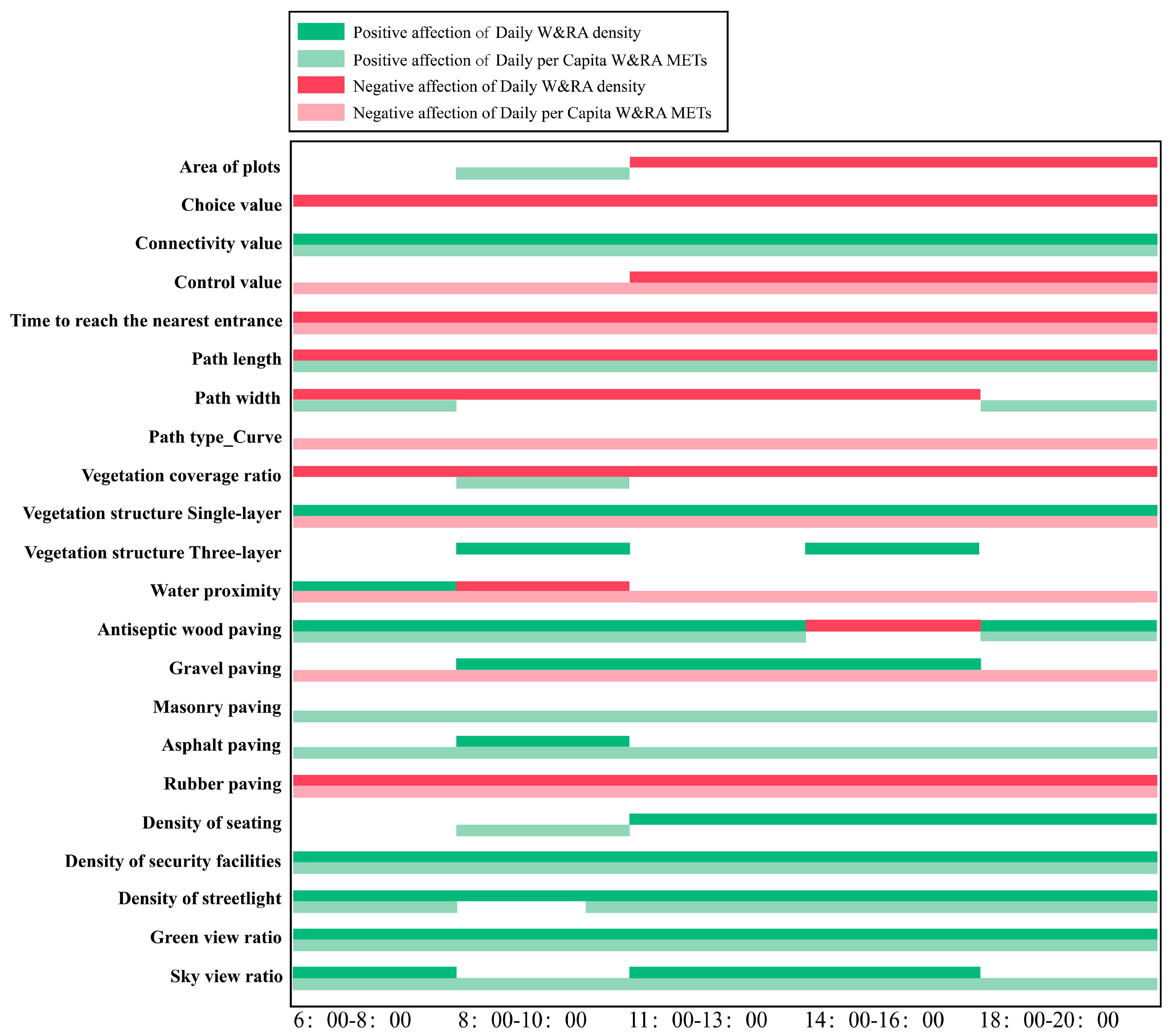
Figure 4 comprehensively illustrates the temporal dynamics of these spatial features’ impacts on walking and running activities throughout the day. Some spatial features exert a significant influence on walking and running during all time periods, whereas others only impact activity during specific intervals.
4.3.1. Spatial Features Influencing Walking and Running Activities Throughout All Time Periods
Connectivity, green view index, streetlight density, safety facility density, and single-layer vegetation structure consistently exhibit significant positive effects on walking and running activity density across all time periods in a day. Conversely, integration (selectivity), time to nearest entrance, path length, vegetation coverage, and rubber pavement continuously inhibit activity density. Additionally, anti-corrosion wood pavement shows a negative impact on activity density during 14:00–16:00, while it promotes activity density in other time periods.
Regarding activity intensity, connectivity, path length, sky openness, green view index, safety facility density, as well as brick and asphalt pavements, maintain significant positive effects across all periods. In contrast, control value, time to nearest entrance, curved roads, a single-layer vegetation structure, proximity to water bodies, gravel, and rubber pavements persistently suppress activity intensity.
From a spatial syntax perspective, high connectivity indicates numerous spatial intersections and richer route choices, facilitating the natural flow of people and thereby enhancing walking and running density and intensity [
40,
41]. High selectivity and control values represent complex spatial networks, which may disrupt exercise rhythms, thus inhibiting activity density and intensity [
42]. A shorter time to entrance attracts more users by enabling quicker access and completion of activities, which may boosting activity density and intensity.
Regarding spatial place features, abundant greenery notably affects walking and running activity density and intensity. A single-layer vegetation structure supports activity occurrence due to better visual permeability, but its negative effect on activity intensity may stem from insufficient shading leading to heat stress. Excessive vegetation coverage can create enclosed sightlines, increasing the psychological burden during exercise and thus discouraging activity. Suitable path length influences the available walking or running distance; longer paths provide more route options, typically enhancing activity density and intensity. Prior studies indicate that parks with loop trails (longer paths) significantly increase medium-to-high intensity walking and running activities, with higher user counts compared to parks lacking loops [
43]. Moreover, curved roads increase route diversity and interest, fostering “exploratory” motivation and favoring low-intensity walking and running. Similarly, proximity to water bodies (lakes, fountains) attracts more low-intensity activities, as these areas provide comfortable microclimates with cooling effects and esthetic relaxation. Residents living near water bodies tend to prefer low-intensity leisure walking [
37]. Anti-corrosion wood pavement offers a skin-friendly and visually pleasant surface during the morning and evening but may overheat under strong afternoon sunlight (14:00–16:00), explaining its negative effect during that period.
Regarding spatial perception features, sky openness and green view index reflect park microclimate and landscape effects. A higher Green view ratio creates a lush and visually comfortable environment, which can reduce emotional stress and enhance physical and psychological comfort [
44]. It may therefore promote both activity density and activity intensity throughout the day. A higher sky openness means more open visual space and sunlight, enhancing spatial perception and sun exposure during exercise; although strong midday sun can increase heat stress, moderate lighting generally fosters a positive mood and activity intensity. Adequately arranged streetlights and safety facilities improve visibility and safety perception, eliminating “dark corners” [
45]. This safety effect benefits not only nighttime but also early morning and dusk exercisers.
Overall, these spatial features jointly influence walking and running activities throughout all time periods by facilitating accessibility, psychological comfort, and safety.
4.3.2. Spatial Features Influencing Activities During Partial Time Periods
Regarding activity density, park area, control value, and seating density only significantly affect activity density in the latter three time periods of the day, with park area and control value showing negative impacts and seat density positive. Pathway width positively affects activity density during the first four time periods. Sky openness promotes activity density from 6:00 to 8:00 but suppresses it from 11:00 to 13:00 and 14:00–16:00. Three-layer vegetation structure promotes activity density only during 8:00–10:00 and 14:00–16:00. Gravel pavement has a positive impact on activity density during 8:00–16:00, while asphalt pavement only during 8:00–10:00. Proximity to water bodies promotes activity density at 6:00–8:00 but reduces it at 8:00–10:00.
Park area, control value, and seating density become significant in the midday and afternoon periods, suggesting that under stronger sunlight and higher temperatures, users prefer smaller spaces with opportunities to rest. High seat density supports groups needing frequent breaks (e.g., elderly, families), thereby extending park usage time [
46]. Pathway width is significant from morning to afternoon, likely because wider paths accommodate multidirectional flows and different paces, avoiding congestion and improving comfort [
47]. The varying effects of sky openness reflect different solar altitudes; openness in the morning improves light and airflow, whereas partial shading at noon mitigates harsh sunlight, enhancing exercise comfort [
48]. The triple-layer vegetation structure provides shade during warmer periods, lowering ambient temperature and improving comfort for walking and running [
49]. Gravel pavement’s positive influence may be due to its natural texture and elasticity, favorable for daytime slow jogging and walking; asphalt pavement’s positive effect during 8:00–10:00 aligns with moderate temperatures and light sunshine, while later heat buildup reduces comfort [
50]. Water bodies attract morning exercisers with cooling effects and scenery, but midday glare and humidity may reduce attractiveness [
38].
Regarding activity intensity, streetlight density positively affects intensity during all periods except 8:00–10:00. Anti-corrosion wood pavement promotes activity intensity in all periods except 14:00–16:00. Pathway width increases intensity only at 6:00–8:00 and 18:00–20:00. Park area, seat density, and vegetation coverage promote intensity only at 8:00–10:00.
The positive impact of streetlights on activity intensity is especially notable during low-light periods (early morning and evening), indicating that good lighting effectively extends park use and enhances safety perception during these times [
51]. Wood pavement, associated with comfort and esthetics, often improves walking stability compared to asphalt or concrete [
52], thus supporting higher activity intensity except under midday heat. Pathway width’s influence peaks during peak visitor periods (6:00–8:00 and 18:00–20:00), reducing congestion and facilitating faster, more continuous movement [
47]. Therefore, during peak periods, pathway width is positively associated with walking and running intensity, as wider paths help reduce congestion and support more stable, continuous movement. In contrast, during off-peak hours with lower foot traffic, the effect of width on activity intensity becomes negligible. Finally, during the morning exercise peak between 8:00 and 10:00, park area, seat density, and vegetation coverage exert significant positive effects on activity intensity. A larger park area indicates more diverse spatial environments and route options, which attract a wider range of users for morning workouts [
53]; High seat density offers convenience for elderly individuals or users who require intermittent rest, thereby extending activity duration [
44]; increased vegetation coverage provides greater shade and contributes to a more comfortable microclimate [
54], which is particularly beneficial in the bright morning hours, thus encouraging higher exercise intensity.
Beyond spatial features themselves, user composition and activity purpose may also influence the model results. User groups may vary substantially across time periods: regular exercisers may be more concentrated in the early morning and evening, whereas midday use may be dominated by short-duration through-movement or leisure-based stationary activities. Activity patterns may also differ between weekdays and weekends. Older adults, children, family groups, and runners may have different needs for density of seats, shading, path width, and pavement comfort [
46,
47]. In addition, the high-density built environment of central Shanghai, the culture of community park use, and collective exercise habits may shape how plazas and pathways are actually used. Therefore, the time-period-specific effects identified in this study should be understood as the joint outcomes of spatial features, intra-day environmental conditions, and user behavior.
4.4. Practical Implications: Design and Management Based on Spatial Type and Intra-Day Variation
Based on the above findings, practical implications can be developed along two dimensions: spatial type and intra-day period. For pathway spaces, priority should be given to route continuity, pavement stability, visual permeability, and the provision of security facilities. Because pathways are the primary spaces supporting sustained walking and running activities, excessive facilities that occupy linear movement space should be avoided, while appropriate Path width and clear route guidance should be maintained. For higher-intensity activities, such as brisk walking, jogging, and running, stable, slip-resistant, and thermally comfortable pavement materials should be prioritized. Lighting and security facilities should also be strengthened during the early morning and evening periods.
For plaza spaces, emphasis should be placed on multifunctional use and peak-activity management. Plazas can accommodate group exercise and periodic high-density activity, but they may also generate conflicts among resting, socializing, and exercise-related uses. In design practice, moderate separation among activity areas, resting areas, and circulation areas can help reduce interference among different behaviors. Seat and shading facilities can support resting and low-intensity activities, but their layout should avoid compressing primary activity interfaces or disrupting pedestrian movement.
From a temporal management perspective, the early morning and evening periods should prioritize safety, lighting conditions, and route continuity to support frequent and higher-intensity walking and running activities. During midday and afternoon periods, greater attention should be paid to shading, cooling, and resting conditions to reduce the constraints of heat exposure on activity. For waterfront spaces, open spaces, and areas with high levels of greenery, refined management should be implemented according to microclimatic conditions across different periods of the day, rather than treating these spaces as consistently health-promoting resources for physical activity.
4.5. Implications and Limitations
This study makes three key contributions. First, through a year-long continuous field observations, it systematically collected walking and running data spanning seasons, climate conditions, diurnal periods, and workdays versus non-workdays. This comprehensive data acquisition effectively controlled environmental confounders, enhancing the stability and representativeness of the results. The rich dataset also enabled the inclusion of a wide range of urban park spatial variables, deepening the analytical scope. Second, the study integrated spatial type (paths vs. plazas) and temporal (morning, midday, afternoon, evening, night) dimensions to reveal the mechanisms by which park spatial features influence walking and running. Third, it examined effects on both activity density and intensity, avoiding biases inherent in single-metric studies, and offering more comprehensive empirical evidence to advance the understanding of spatial-physical activity relationships in urban parks.
Nevertheless, limitations exist. First, the study’s cross-sectional design does not allow for causal inference regarding the relationship between spatial features and walking and running activities. Future studies should consider longitudinal tracking or experimental interventions to further verify causal mechanisms. Second, the research focused on three comprehensive urban parks in Shanghai, China. Differences in park design standards, cultural practices, and resident behaviors across regions may limit the generalizability of the findings. Future research should be extended to different cities and countries to improve the applicability and policy relevance of the results. Third, the study used OLS models to identify average linear relationships, which may not fully capture nonlinear thresholds, variable interactions, or local spatial heterogeneity. Future studies could employ spatial econometric models, geographically weighted regression, generalized additive models, or machine learning approaches to identify nonlinear relationships and spatially heterogeneous effects.
5. Conclusions
Based on long-term field observations of 30 spatial units in three representative urban parks in Shanghai from 2021 to 2023, this study systematically examined the relationship between micro-scale spatial features and walking and running activities. It further identified differentiated effects on Daily W&RA density and Daily per capita W&RA METs across space types and intra-day periods.
First, this study contributes theoretically by shifting the analytical scale from parks as whole units to micro-scale spatial units within parks, thereby addressing the limited attention previously given to specific space types such as pathways and plazas. The results show that pathway and plaza spaces differ not only in average activity levels but also in activity variability and peak-use patterns. Pathway spaces more consistently support routine and continuous walking and running activities, whereas plaza spaces are more likely to generate periodic or clustered activity peaks. By examining both Daily W&RA density and Daily per capita W&RA METs, this study also shows that activity density and activity intensity are not shaped by identical spatial factors, deepening the understanding of the spatiotemporal heterogeneity of health-promoting park environments.
Second, the findings suggest that spatial optimization for walking and running should not rely on a uniform design logic, but should be refined according to space type and time of use. For pathway spaces, greater attention should be given to route continuity, entrance accessibility, visual permeability, pavement stability, lighting, and security facilities to support sustained strolling, brisk walking, jogging, and running. For plaza spaces, design and management should emphasize multifunctional use and peak-activity management, balancing group activities, resting, and pedestrian circulation. Safety, visibility, and moderate green perception are important baseline conditions for supporting walking and running activities. However, the effects of vegetation complexity, water proximity, sky view ratio, and pavement type are context-dependent and should be evaluated in relation to space type, activity intensity, and intra-day period.
Third, future research should extend this work within broader geographical and methodological frameworks. Cross-regional comparative studies across different cities, climate zones, and sociocultural contexts are needed to test the applicability and boundary conditions of the findings. Future studies should also integrate microclimate monitoring, user-profile identification, and activity-purpose classification to better explain the differentiated effects of spatial features across time periods and space types. In addition, spatial econometric models, geographically weighted regression, generalized additive models, and machine learning approaches could be introduced to capture nonlinear relationships, interaction effects, and local spatial heterogeneity. Integrating ecosystem-service assessment and ecological carrying capacity analysis would further clarify how park spatial features jointly support physical activity, ecological functions, and urban resilience.
Overall, this study demonstrates that the effects of urban park spatial features on walking and running activities are neither static nor homogeneous, but are jointly moderated by space type, activity indicator, and intra-day period. These findings provide micro-scale and spatiotemporal evidence for understanding the complex relationship between urban park environments and health-related behaviors, while also offering empirical support for health-oriented park planning, design, and management.
Author Contributions
Conceptualization, J.C.; Methodology, J.C.; Software, J.C., Z.T., W.W. and Y.W.; Validation, L.W. and D.C.; Formal analysis, J.C.; Investigation, J.C.; Resources, Z.T., W.W., Y.W., L.W. and D.C.; Data curation, J.C., Z.T., W.W. and Y.W.; Writing – original draft, J.C.; Writing – review & editing, J.C.; Visualization, J.C.; Supervision, L.W. and D.C.; Project administration, D.C.; Funding acquisition, D.C. All authors have read and agreed to the published version of the manuscript.
Funding
This research was funded by National Natural Science Foundation of China, grant number 32001361.
Data Availability Statement
The raw data supporting the conclusions of this article will be made available by the authors on request.
Conflicts of Interest
The authors declare no conflict of interest.
References
- Williams, P.T.; Thompson, P.D. Walking versus running for hypertension, cholesterol, and diabetes mellitus risk reduction. Arterioscler. Thromb. Vasc. Biol. 2013, 33, 1085–1091. [Google Scholar] [CrossRef]
- Kaczynski, A.T.; Henderson, K.A. Environmental correlates of physical activity: A review of evidence about parks and recreation. Leis. Sci. 2007, 29, 315–354. [Google Scholar] [CrossRef]
- Zuniga-Teran, A.A.; Stoker, P.; Gimblett, R.H.; Orr, B.J.; Marsh, S.E.; Guertin, D.P.; Chalfoun, N.V. Exploring the influence of neighborhood walkability on the frequency of use of greenspace. Landsc. Urban Plan. 2019, 190, 103609. [Google Scholar] [CrossRef]
- Jiang, Y.; Zhen, F.; Wang, W.; Zhao, M. Influence of urban built environment on residents’ physical activity: Review and implications. Prog. Geogr. 2019, 38, 357–369. [Google Scholar]
- Chen, J.; Tao, Z.; Wu, W.; Wang, L.; Chen, D. Influence of urban park pathway features on the density and intensity of walking and running activities: A case study of Shanghai city. Land 2024, 13, 156. [Google Scholar] [CrossRef]
- Liu, M.; Chen, C.; Yan, J. Identifying park spatial features that encourage moderate-to-vigorous physical activity among park visitors. Land 2023, 12, 717. [Google Scholar] [CrossRef]
- Tao, Z.; Chen, J.; Wu, W.; Ding, J.; Wang, L.; Zhu, Z.; Chen, D. Spatiotemporal association of urban park features and physical activity levels based on GTWR: A serial cross-sectional observational study. J. Urban Manag. 2024, 13, 398–409. [Google Scholar] [CrossRef]
- Yang, Q.; Gao, X.; Lindquist, M.; Song, Y.; Shen, X. Temporal and Spatial Dynamics of Peak-Time Urban Park Visitation: Investigating Influencing Factors Across Scales in Post-Pandemic Detroit. Urban For. Urban Green. 2025, 112, 128871. [Google Scholar] [CrossRef]
- Sellers, C.; Grant, P.; Ryan, C.; O’Kane, C.; Raw, K.; Conn, D. Take a walk in the park? A cross-over pilot trial comparing brisk walking in two different environments: Park and urban. Prev. Med. 2012, 55, 438–443. [Google Scholar] [CrossRef] [PubMed]
- Lin, C.Y.; Lai, T.F.; Fang, C.Y.; Hsueh, M.C.; Liao, Y. Park proximity and all-day and time-specific physical activity and sedentary behaviour in older adults. BMC Geriatr. 2024, 24, 938. [Google Scholar] [CrossRef] [PubMed]
- Evenson, K.R.; Jones, S.A.; Holliday, K.M.; Cohen, D.A.; McKenzie, T.L. Park features, use, and physical activity: A review of studies using SOPARC (System for Observing Play and Recreation in Communities). Prev. Med. 2016, 86, 153–166. [Google Scholar] [CrossRef]
- Koohsari, M.J.; Oka, K.; Owen, N.; Sugiyama, T. Natural movement: A space syntax theory linking urban form and function with walking for transport. Health Place 2019, 58, 102072. [Google Scholar] [CrossRef] [PubMed]
- Zhang, C.; Shi, D.; Xiao, Z. Integrating variable importance and spatial heterogeneity to reveal the environmental effects on outdoor jogging. Comput. Urban Sci. 2024, 4, 45. [Google Scholar] [CrossRef]
- Wang, N.; Wang, Q.; Wei, W.; Liu, G.; Liu, M. Landscape Scene Sequences of Park View Elements Facilitate Walking, Jogging, and Running: Evidence from 3 Parks in Shanghai. Buildings 2025, 15, 1518. [Google Scholar] [CrossRef]
- Ainsworth, B.E.; Haskell, W.L.; Herrmann, S.D.; Meckes, N.; Bassett, D.R.; Tudor-Locke, C.; Greer, J.L.; Vezina, J.; Whitt-Glover, M.C.; Leon, A.S. 2011 Compendium of Physical Activities: A second update of codes and MET values. Med. Sci. Sports Exerc. 2011, 43, 1575–1581. [Google Scholar] [CrossRef]
- Chen, L.; Wen, Y.; Zhang, L.; Xiang, W.-N. Studies of thermal comfort and space use in an urban park square in cool and cold seasons in Shanghai. Build. Environ. 2015, 94, 644–653. [Google Scholar] [CrossRef]
- Wang, X.; Wu, C. An observational study of park attributes and physical activity in neighborhood parks of Shanghai, China. Int. J. Environ. Res. Public Health 2020, 17, 2080. [Google Scholar] [CrossRef]
- Schuurman, N.; Rosenkrantz, L.; Lear, S.A. Environmental preferences and concerns of recreational road runners. Int. J. Environ. Res. Public Health 2021, 18, 6268. [Google Scholar] [CrossRef]
- Hou, Y.; Zhao, X.; Zhang, B. Significance Analysis between Morning Exercise and Spatial Organization features of Urban Park—Taking 4 Urban Parks in Harbin for Example. Landsc. Archit. 2017, 24, 109–116. [Google Scholar]
- Alwah, A.; Wen, I.; Mofreh, B.; Drmoush, A.; Brook, K.; Ali, N.; Al-Shalafy, H.; Alwah, M. Intensity and Diversity of Use as a Tool to Measure the Quality of Public Spaces. J. Sustain. Cities Built Environ. 2023, 1, 41–69. [Google Scholar] [CrossRef]
- Foster, S.; Giles-Corti, B. The built environment, neighborhood crime and constrained physical activity: An exploration of inconsistent findings. Prev. Med. 2008, 47, 241–251. [Google Scholar] [CrossRef]
- Molnar, B.E.; Gortmaker, S.L.; Bull, F.C.; Buka, S.L. Unsafe to play? Neighborhood disorder and lack of safety predict reduced physical activity among urban children and adolescents. Am. J. Health Promot. 2004, 18, 378–386. [Google Scholar] [CrossRef] [PubMed]
- Ma, M.; Bob, M.; Cai, Z. Research on the Determinants of Urban Open Green Space Design Affecting the Physical Activity from the Perspective of Health. Landsc. Archit. 2018, 25, 92–97. [Google Scholar]
- Paydar, M.; Kamani Fard, A.; Gárate Navarrete, V. Design features, Visual Qualities, and Walking Behavior in an Urban Park Setting. Land 2023, 12, 1838. [Google Scholar] [CrossRef]
- Nasiri, M.; Pourmajidian, M.R. Effects of vegetation type on line of sight. J. For. Sci. 2014, 60, 208–211. [Google Scholar] [CrossRef]
- Deelen, I.; Janssen, M.; Vos, S.; Kamphuis, C.B.M.; Ettema, D. Attractive running environments for all? A cross-sectional study on physical environmental characteristics and runners’ motives and attitudes, in relation to the experience of the running environment. BMC Public Health 2019, 19, 366. [Google Scholar] [CrossRef]
- Ettema, D. Runnable cities: How does the running environment influence perceived attractiveness, restorativeness, and running frequency? Environ. Behav. 2016, 48, 1127–1147. [Google Scholar] [CrossRef]
- Rivera, E.; Timperio, A.; Loh, V.H.; Deforche, B.; Veitch, J. Critical factors influencing adolescents’ active and social park use: A qualitative study using walk-along interviews. Urban For. Urban Green. 2021, 58, 126948. [Google Scholar] [CrossRef]
- Bjerke, T.; Østdahl, T.; Thrane, C.; Strumse, E. Vegetation density of urban parks and perceived appropriateness for recreation. Urban For. Urban Green. 2006, 5, 35–44. [Google Scholar] [CrossRef]
- Córdoba Hernández, R.; Camerin, F. Assessment of ecological capacity for urban planning and improving resilience in the European framework: An approach based on the Spanish case. Cuad. Investig. Geográfica 2023, 49, 119–142. [Google Scholar] [CrossRef]
- Zhao, X.; Hou, Y.; Qiu, X.; Lv, F. The Study on Morphological features of Pathway in Urban Parks Based on Walking and Running Capacity—A Case of Harbin City. Chin. Landsc. Archit. 2019, 35, 12–17. [Google Scholar] [CrossRef]
- Hacar, Ö.Ö.; Gülgen, F.; Bilgi, S. Evaluation of the space syntax measures affecting pedestrian density through ordinal logistic regression analysis. ISPRS Int. J. Geo-Inf. 2020, 9, 589. [Google Scholar] [CrossRef]
- Mak, B.K.L.; Jim, C.Y. Examining fear-evoking factors in urban parks in Hong Kong. Landsc. Urban Plan. 2018, 171, 42–56. [Google Scholar] [CrossRef]
- Liu, H.; Li, F.; Li, J.; Zhang, Y. The relationships between urban parks, residents’ physical activity, and mental health benefits: A case study from Beijing, China. J. Environ. Manag. 2017, 190, 223–230. [Google Scholar] [CrossRef]
- Chiang, Y.C.; Weng, P.Y.; Li, D.; Ho, L.C. Quantity and quality: Role of vegetation in park visitation and physical activity. Landsc. Ecol. Eng. 2023, 19, 337–350. [Google Scholar] [CrossRef]
- Zhang, S.; Zhou, W. Recreational visits to urban parks and factors affecting park visits: Evidence from geotagged social media data. Landsc. Urban Plan. 2018, 180, 27–35. [Google Scholar] [CrossRef]
- Sitohang, I.; Belaroussi, R.; Adelé, S.; Imine, H. The effect of access to waterbodies and parks on walking and cycling in urban areas. Infrastructures 2024, 9, 235. [Google Scholar] [CrossRef]
- Christian, H.; Knuiman, M.; Divitini, M.; Foster, S.; Hooper, P.; Boruff, B.; Bull, F.; Giles-Corti, B. A longitudinal analysis of the influence of the neighborhood environment on recreational walking within the neighborhood: Results from RESIDE. Environ. Health Perspect. 2017, 125, 077009. [Google Scholar] [CrossRef] [PubMed]
- Schipperijn, J.; Bentsen, P.; Troelsen, J.; Toftager, M.; Stigsdotter, U.K. Associations between physical activity and features of urban green space. Urban For. Urban Green. 2013, 12, 109–116. [Google Scholar] [CrossRef]
- Koohsari, M.J.; Owen, N.; Cerin, E.; Giles-Corti, B.; Sugiyama, T. Walkability and walking for transport: Characterizing the built environment using space syntax. Int. J. Behav. Nutr. Phys. Act. 2016, 13, 121. [Google Scholar] [CrossRef]
- McCormack, G.R.; Koohsari, M.J.; Turley, L.; Nakaya, T.; Shibata, A.; Ishii, K.; Yasunaga, A.; Oka, K. Evidence for urban design and public health policy and practice: Space syntax metrics and neighborhood walking. Health Place 2021, 67, 102277. [Google Scholar] [CrossRef]
- Şahin Körmeçli, P. Analysis of walkable street networks by using the space syntax and GIS techniques: A case study of Çankırı City. ISPRS Int. J. Geo-Inf. 2023, 12, 216. [Google Scholar] [CrossRef]
- Cohen, D.A.; Han, B.; Evenson, K.R.; Nagel, C.; McKenzie, T.L.; Marsh, T.; Williamson, S.; Harnik, P. The prevalence and use of walking loops in neighborhood parks: A national study. Environ. Health Perspect. 2017, 125, 170–174. [Google Scholar] [CrossRef]
- Liu, X.T.; Sun, B.; Liao, C.; Jin, J.L.; Shi, Z.W.; Fan, L.M.; Tang, Y.-J.; He, J.-H.; He, W.-Z.; Yang, L.; et al. Comparison of Computational Methods for Urban Street Green View Indexes Based on Street View Images. Acta Agric. Univ. Jiangxiensis 2020, 42, 1022–1031. [Google Scholar]
- Trovato, B.; Godos, J.; Varrasi, S.; Roggio, F.; Castellano, S.; Musumeci, G. Physical activity, sun exposure, vitamin D intake and perceived stress in Italian adults. Nutrients 2023, 15, 2301. [Google Scholar] [CrossRef]
- Zhai, Y.; Li, D.; Wang, D.; Shi, C. Seniors’ physical activity in neighborhood parks and park design features. Front. Public Health 2020, 8, 322. [Google Scholar] [CrossRef] [PubMed]
- Li, C.; Lee, C.W.; Tsang, K.T. Outdoor walking better? Environmental elements of cardiorespiratory fitness training trails. Front. Sports Act. Living 2023, 4, 1036777. [Google Scholar] [CrossRef] [PubMed]
- Lin, T.P.; Tsai, K.T.; Hwang, R.L.; Matzarakis, A. Quantification of the effect of thermal indices and sky view factor on park attendance. Landsc. Urban Plan. 2012, 107, 137–146. [Google Scholar] [CrossRef]
- Mao, Y.; Li, K.; Li, Y.; Wei, J. Research on Influence Mechanism of Park Green Space features on Physical Activity: A Case Study of Nanjing. Landsc. Archit. 2024, 31, 103–111. [Google Scholar] [CrossRef]
- Tessutti, V.; Ribeiro, A.P.; Trombini-Souza, F.; Sacco, I.C. Attenuation of foot pressure during running on four different surfaces: Asphalt, concrete, rubber, and natural grass. J. Sports Sci. 2012, 30, 1545–1550. [Google Scholar] [CrossRef]
- Huang, C.K.; Chien, J.H.; Siu, K.C. The reduced lighting environment impacts gait features during walking. Int. J. Ind. Ergon. 2017, 61, 126–130. [Google Scholar] [CrossRef]
- Jo, D.; Kim, H. Evaluating walkability across age groups and flooring materials using IMU sensors. Front. Public Health 2024, 12, 1509602. [Google Scholar] [CrossRef]
- Cohen, D.A.; McKenzie, T.L.; Sehgal, A.; Williamson, S.; Golinelli, D.; Lurie, N. Contribution of public parks to physical activity. Am. J. Public Health 2007, 97, 509–514. [Google Scholar] [CrossRef] [PubMed]
- Zhang, Y.; Van den Berg, A.E.; Van Dijk, T.; Weitkamp, G. Quality over quantity: Contribution of urban green space to neighborhood satisfaction. Int. J. Environ. Res. Public Health 2017, 14, 535. [Google Scholar] [CrossRef] [PubMed]
| Disclaimer/Publisher’s Note: The statements, opinions and data contained in all publications are solely those of the individual author(s) and contributor(s) and not of MDPI and/or the editor(s). MDPI and/or the editor(s) disclaim responsibility for any injury to people or property resulting from any ideas, methods, instructions or products referred to in the content. |