Review

Geographically Weighted Regression: A Systematic Review of Methods, Development, and Applications

1
School of Government, Peking University, Beijing 100871, China
2
School of Management Science & Real Estate, Chongqing University, Chongqing 400044, China
*
Author to whom correspondence should be addressed.
Land 2026, 15(6), 915; https://doi.org/10.3390/land15060915
Submission received: 6 April 2026 / Revised: 15 May 2026 / Accepted: 17 May 2026 / Published: 26 May 2026

Abstract

Over the past three decades, geographically weighted regression (GWR) and multiscale geographically weighted regression (MGWR) have become essential tools for spatial analysis in urban, environmental, and land-use research. This scoping review systematically maps and synthesizes the global literature on GWR and MGWR published between 1996 and 2026, aiming to identify the research hotspots, evolutionary paths, and cutting-edge trends. Bibliometrics and CiteSpace visualization tools are used to conduct a multi-dimensional visual analysis of thousands of selected articles, including countries, institutions, core authors, highly cited keywords, and key documents. The results show that the current research focuses on spatial heterogeneity, multiscale analysis, GWR model optimization, non-stationarity characterization, and simulation of urban land-use change. Potential future directions include the construction of spatiotemporal integrated models, the integration of high-performance computing, and the expansion of interdisciplinary applications. The results of this study can help scholars fully understand the current research status and future directions, and provide a scientific spatial analysis framework for practitioners in urban planning, land resource management, and environmental assessment. Furthermore, the conclusions can provide theoretical support and a decision-making basis for the government to formulate intelligent and refined urban development policies.

1. Introduction

Over the past three decades, geographically weighted regression (GWR) has evolved from an exploratory technique into a foundational methodology in spatial analysis [1,2,3]. Originally introduced to address the inability of global regression models to capture spatial heterogeneity [3,4], GWR has matured through continuous theoretical innovation, statistical improvement, and interdisciplinary application [5,6]. The paradigm shift from global uniformity to local adaptivity has greatly strengthened the empirical and theoretical strength of spatial analysis in the social sciences, environmental studies, public health, and urban planning [2,5,7]. By allowing regression coefficients to vary locally via spatial weighting, GWR formalizes the first law of geography in a statistically rigorous manner and avoids the model misspecification, biased estimation, and misleading policy inferences that often arise under the unrealistic assumption of global stationarity.
Driven by diverse geographic scenarios and analytical demands, a growing number of modified GWR variants have been successively developed to compensate for the limitations of the conventional model, covering multiscale optimization, spatiotemporal coupling, Bayesian correction, and machine learning hybrid frameworks [1,6,8]. These extended models substantially broaden the applicable boundary of local spatial regression and further enhance the adaptability of GWR in complex nonlinear and non-stationary geographic datasets. Despite the rapid methodological progress, existing review studies generally present fragmented summaries of individual model branches or merely organize empirical application cases [9,10]. There remains a lack of systematic collation regarding the internal evolutionary logic, hierarchical relationships, and comparative methodological advantages among diverse GWR derivatives [5]. In addition, the inherent defects, applicable preconditions, and algorithmic constraints of each extended model have not been objectively and quantitatively summarized, which may cause arbitrary model selection and inconsistent analytical standards for spatial researchers [11,12].
This review presents a retrospective analysis of the evolution of GWR and its multiscale extensions, especially Multiscale GWR (MGWR), which overcomes the limitation of a single uniform bandwidth for all covariates [6,8]. Following the influential framework of spatial econometrics [1], we divide GWR development into three clear phases: conceptual emergence (1996–2001), methodological takeoff (2002–2016), and multiscale and computational maturity (2017–present). We review key advances in estimation, diagnostics, software, and integration with machine learning, Bayesian methods, and spatial panel techniques [9]. We also highlight real-world applications in urban form, climate science, and COVID-19 spatial modeling [13,14,15], while identifying persistent challenges including multicollinearity, statistical uncertainty, and spatiotemporal generalization.
Accordingly, this paper aims to construct a holistic methodological framework for the GWR family of models. The primary objectives of this study are: (1) to systematically investigate the theoretical derivation and developmental evolution of conventional and extended GWR models; (2) to objectively compare the adaptive conditions, advantages, and persistent limitations of each model variant; (3) to summarize the current application status across multiple geographic disciplines; (4) to carry out an in-depth discussion of the integration mechanism and development potential between GWR models and emerging machine learning techniques. This review not only helps clarify the internal methodological logic of spatial local regression and unify the cognitive framework of multi-type GWR extensions, but also provides explicit theoretical references and practical guidelines for subsequent spatial modeling optimization, model improvement, and interdisciplinary application. Furthermore, the prospective insights summarized in this study can offer feasible research directions for future scholars engaged in spatial econometrics, geographic modeling, and intelligent spatial analysis, thereby presenting solid theoretical value and broad application significance.
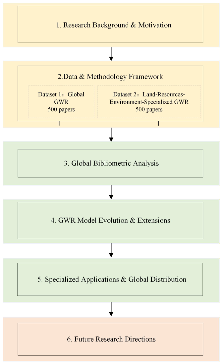
Despite considerable progress, existing reviews remain largely qualitative and subjective, and few provide data-driven knowledge mapping or distinguish between global GWR development and topic-specific applications [16,17]. We constructed two independent core datasets for visualized bibliometric analysis: 500 highly cited articles representing the global GWR domain (from ~7000 publications) and 500 focused on applications in land, resources, and environment (from ~700 topic publications). Using CiteSpace 6.4.1, we reveal collaboration patterns, hotspots, evolutionary trends, co-citation clusters, and global geographic distribution [18,19]. This review summarizes the developmental history, methodological innovations, application domains, and future directions of GWR. It provides a complete, transparent, and reproducible knowledge map for researchers and supports evidence-based model selection and policy design in land use, urban infrastructure, resource allocation, and environmental governance [20,21,22]. The overall research framework is illustrated in Figure 1.

2. Research Methodology

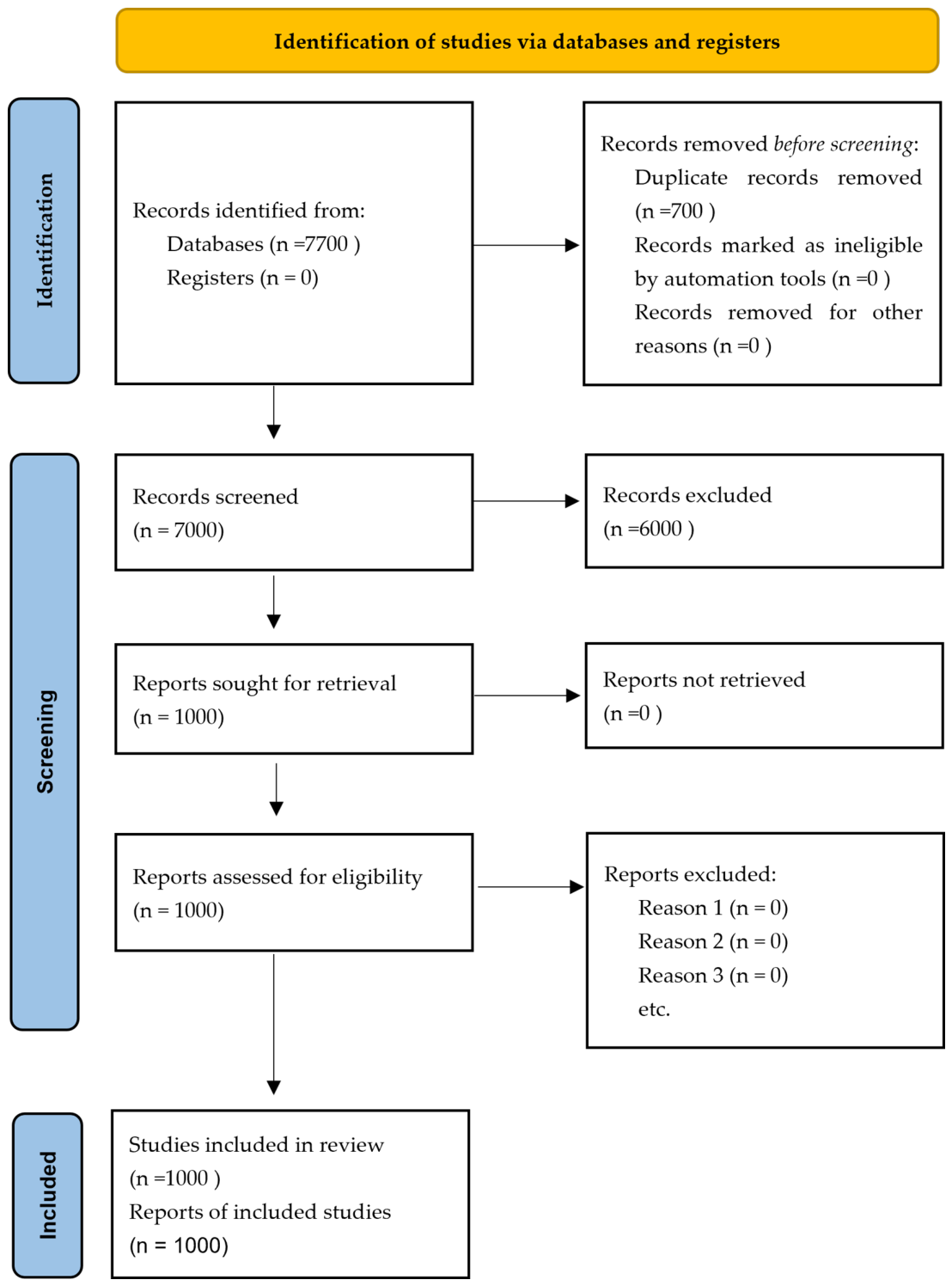
We initially retrieved approximately 7000 bibliographic records related to GWR and MGWR. After rigorous screening to exclude duplicates, editorials, and non-core publications, 1000 high-quality core articles were retained for bibliometric analysis. The reference list in the manuscript includes representative, highly cited, and methodologically foundational works that are essential for contextualizing the review.
This scoping review was reported in accordance with the PRISMA 2019 Extension for Scoping Reviews (PRISMA-ScR) guidelines to ensure transparency, replicability, and methodological rigor throughout the review process. A PRISMA-ScR flow diagram summarizing the study selection process is presented in Figure 2. Details of the search terms, screening criteria, and dataset construction rules are explicitly described below. The completed PRISMA-ScR checklist is provided in the Supplementary Materials.
CiteSpace 6.2.R4 was used for bibliometric visualization, including collaboration networks, keyword co-occurrence, burst detection, author co-citation, and document clustering [23]. Python 3.11 (a general-purpose programming language) and R 4.4.1 (a statistical programming language) were used for data screening, statistical description, and model sorting [24,25].
Literature searches were first conducted using the following GWR-related keywords: geographically weighted regression (GWR), Multiscale GWR (MGWR), and geographically and temporally weighted regression (GTWR). For Dataset 2, we further added the thematic constraints of land use, resources, and the environment to focus on applied studies. The full search time frame was 1996–2026.
Dataset 1 (Global GWR Core) included 500 highly cited articles (1996–2026) from approximately 7000 publications on GWR, MGWR, and GTWR. Dataset 2 (Land–Resources–Environment-Specialized) included 500 core articles from approximately 700 topic-specific publications focusing on GWR applications in land use, resources, environment, and urban infrastructure [26,27]. Duplicates, editorials, and non-core studies were removed manually [28,29].
A dual-structure analysis was adopted. Dataset 1 reveals the global development and knowledge structure of GWR, while Dataset 2 shows the application characteristics and global geographic distribution of GWR in land, resources, and environment [30,31]. The dual-dataset design ensures a comprehensive overview of both methodological progress and practical applications [32].
Bibliometric analysis serves as a supportive tool rather than the core of this review [33]. For GWR/MGWR implementation, we conducted formal bandwidth sensitivity analysis to verify model robustness. The optimal bandwidth was determined using cross-validation (CV) and the Akaike Information Criterion (AIC), two widely accepted methods that minimize prediction error and balance model fit and complexity. For the weighting function, we selected the Gaussian kernel as the primary function due to its smooth decay and computational stability, while the bisquare kernel was also tested for comparison. Sensitivity testing across a range of bandwidth values and kernel specifications confirmed that the results remained stable and consistent, supporting the rationality and reliability of our model settings.

3. Bibliometric Analysis and Knowledge Mapping

3.1. Research Hotspots and Knowledge Structure of GWR

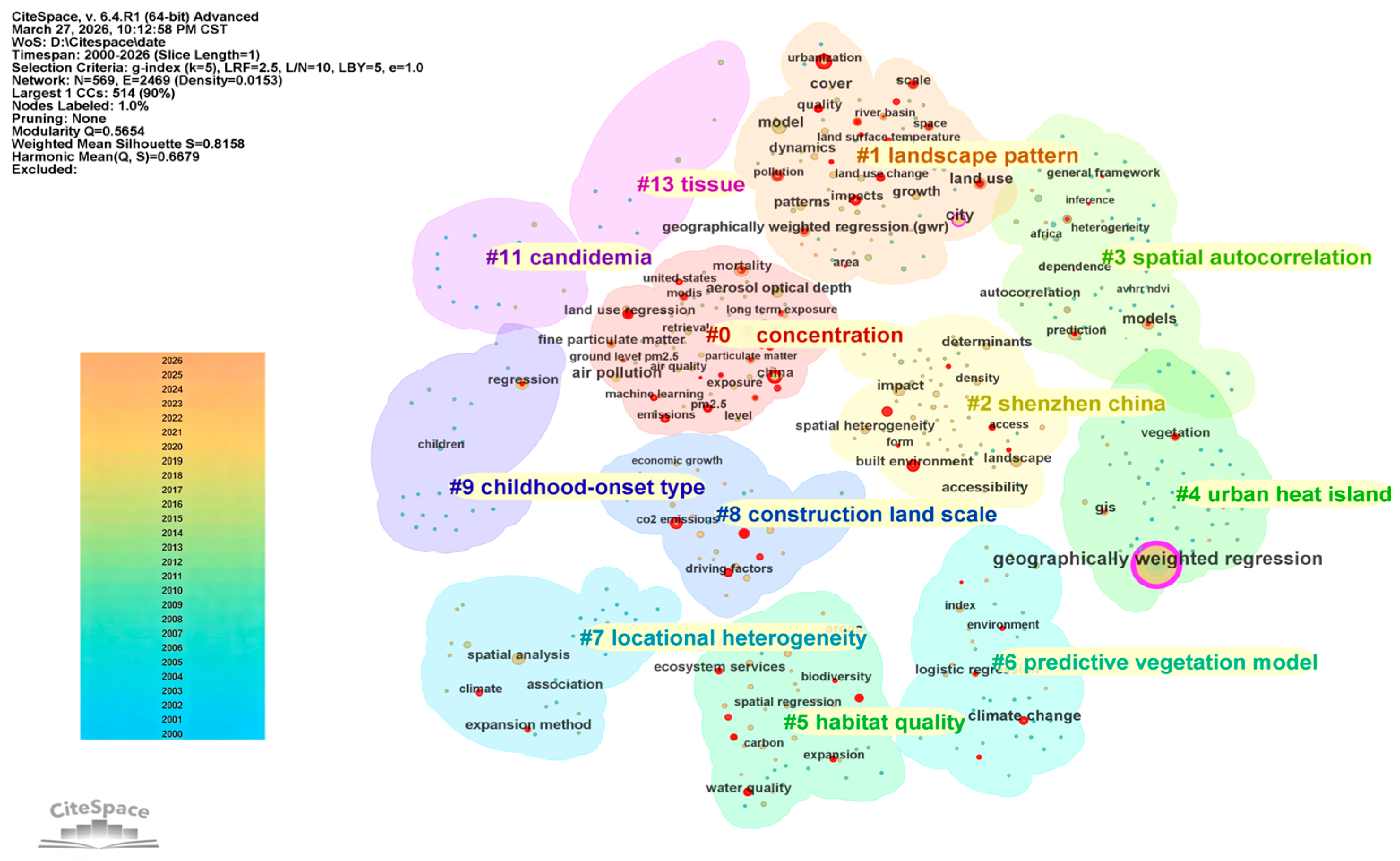
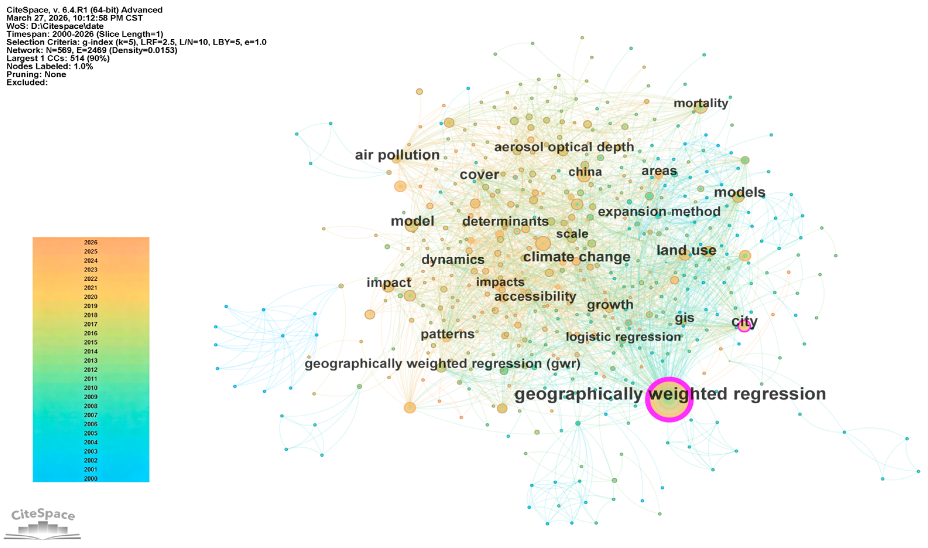
GWR has evolved into a well-structured, interdisciplinary spatial analysis paradigm, with six highly cohesive research clusters that reflect a clear shift from methodological fundamentals to multiscale, spatiotemporal, and AI-enhanced applications [1,4]. Figure 3 and Figure 4 present the keyword co-occurrence network and clustering structure of global GWR research during 1996–2025. Node size represents keyword frequency, and linkage density indicates thematic association. Modularity Q and silhouette S are used to evaluate cluster validity and stability. Q (modularity) ranges from 0 to 1, where Q > 0.7 indicates a significant and reliable clustering structure; S (silhouette coefficient) ranges from −1 to 1, where S > 0.9 suggests high homogeneity and stability within clusters [5,9].
Figure 4 illustrates the keyword co-occurrence clustering structure of global GWR research. As the foundational node, “geographically weighted regression” anchors a broad network covering spatial heterogeneity, land use, urbanization, climate modeling, GIS, and spatial autocorrelation, confirming GWR’s wide penetration into geography, planning, environmental science, and public health [2,7,34]. Six robust clusters are identified: standard GWR, bandwidth optimization, GTWR, MGWR, Generalized GWR, and GWR–machine learning integration. The modularity Q = 0.7682 and silhouette S = 0.959 indicate a statistically significant and logically consistent knowledge domain [9]. Notably, the emergence of MGWR and spatiotemporal models signals a paradigmatic shift from single-scale local regression to process-based multiscale reasoning, which addresses longstanding limitations of classical GWR [4,22,34]. This structural evolution reflects the field’s response to real-world demands for more realistic and interpretable spatial modeling [35].
This intellectual structure directly defines the taxonomic framework of model extensions in Section 4 and the application domains synthesized in Section 5.

3.2. Global Collaborative Network and Spatial Distribution

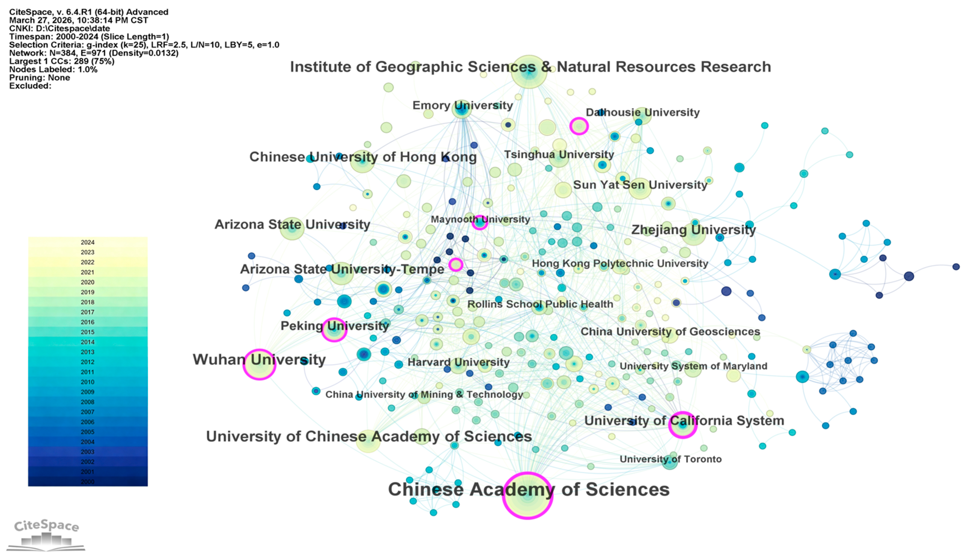
Global GWR research is dominated by China, the United States, the United Kingdom, and Australia, with a dual-center structure: the U.S. and UK lead theoretical innovation, while China leads large-scale applied and computational advances [36,37]. Figure 5 illustrates the international institutional collaboration network. Nodes represent institutions, node size denotes publication output, and link thickness indicates collaborative intensity [38].
Core institutions with outstanding contributions include Arizona State University, the University of California System, Peking University, Wuhan University, and the Chinese Academy of Sciences (CAS) [39,40,41,42]. As the birthplace of classical GWR theory, Arizona State University maintains a central position in theoretical and statistical innovation [2,7,22]. The University of California System serves as a key hub for cross-disciplinary collaboration and methodological advancement in North America. In East Asia, Peking University and Wuhan University have become leading forces in spatial analysis, multiscale modeling, and large-scale empirical applications [13,22,34]. The Chinese Academy of Sciences contributes profoundly to data integration, environmental modeling, and methodological translation for real-world policy support. International cooperation is concentrated between China and the United States, forming a stable collaborative network that advances both theory and practice [4,6,14]. This pattern reveals a clear global division of labor: U.S. institutions focus on theoretical and statistical foundations, while Chinese institutions excel in large-dataset computation, empirical validation, and policy-relevant modeling. The uneven distribution of research capacity across low- and middle-income regions also highlights a critical global gap.
This geographic and institutional pattern explains the application focus and methodological priorities reviewed in Section 5.

3.3. Evolutionary Trends and Emerging Directions in GWR

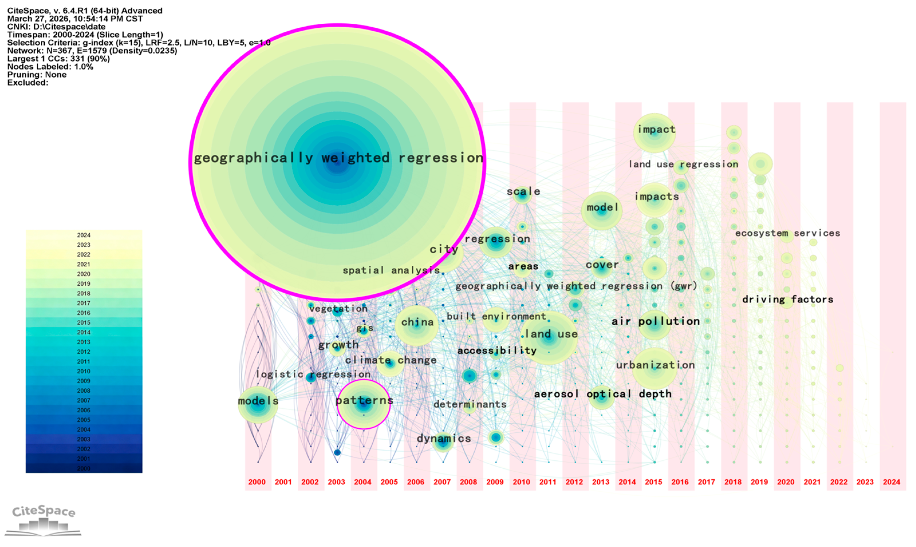
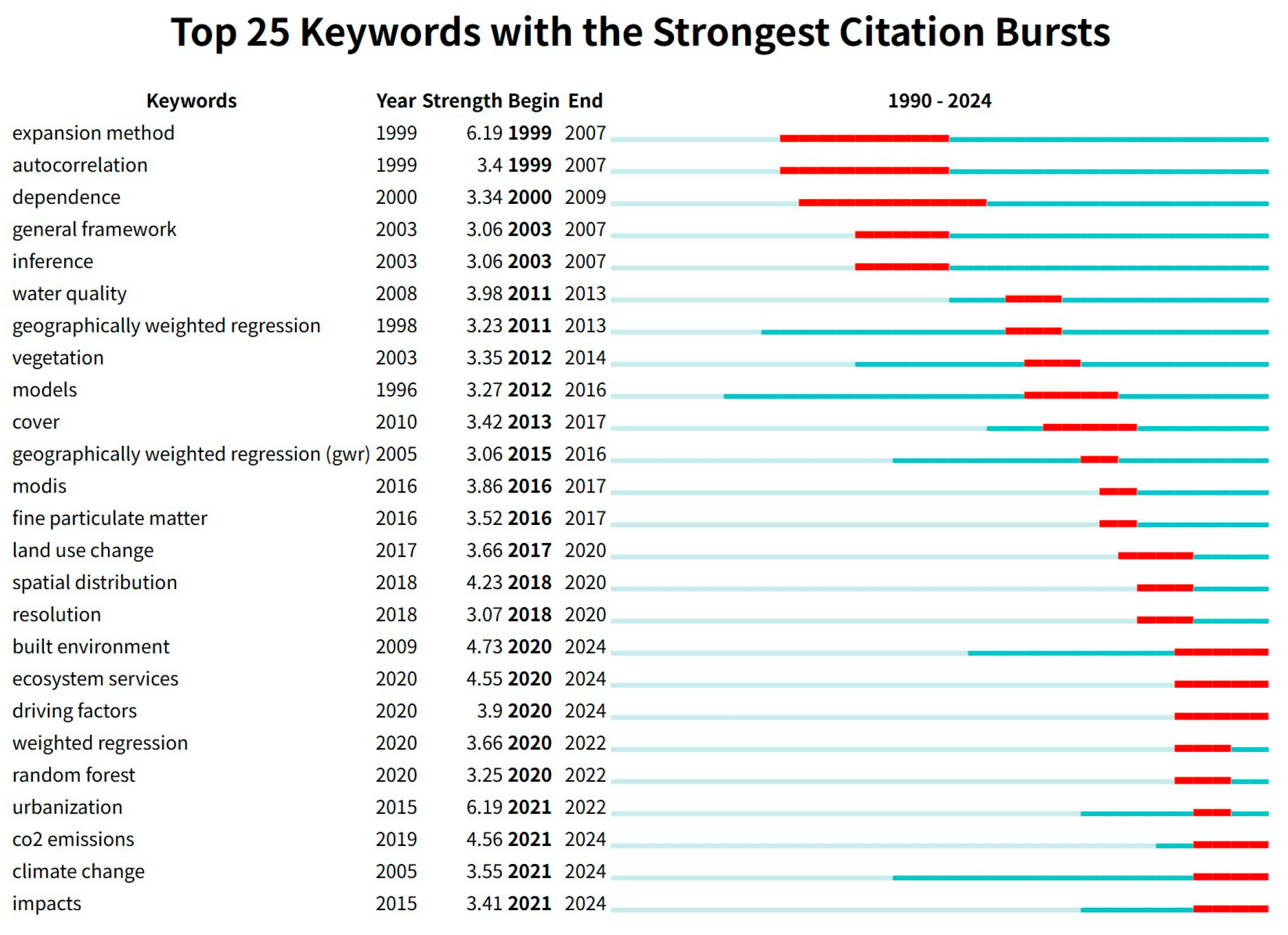
GWR has undergone three distinct evolutionary phases, driven by theoretical limitations, computational advances, and real-world demands [43,44]. The field has shifted from exploratory local regression to a mature multiscale–spatiotemporal–generalized paradigm integrated with geospatial artificial intelligence (GeoAI) [45,46,47]. Figure 6 and Figure 7 show the keyword timeline and citation burst detection across 1996–2025, revealing turning points, paradigm shifts, and emerging frontiers.
In the emergence phase (1996–2001), research focused on spatial nonstationarity, kernel design, and bandwidth selection, establishing GWR as a rigorous alternative to global regression [2,7]. In the methodological takeoff phase (2002–2016), key innovations addressed local collinearity, statistical inference, adaptive bandwidths, and early spatiotemporal extensions [3,5,8]. Since 2017, the multiscale and computational maturity phase has been defined by MGWR, which resolves the single-bandwidth constraint and enables process-sensitive multiscale modeling [4,22,34]. Burst keywords—including urbanization, air pollution, land-use change, and CO2 emissions—reflect a strong turn toward real-world problem-solving. Meanwhile, integration with machine learning and interpretable AI expands predictive capacity while preserving GWR’s core interpretability [1,13,34]. Notably, persistent gaps remain in unified spatiotemporal inference, high-performance computing, causal identification, and generalization to non-Gaussian data.
The bibliometric analysis above reveals the global research landscape, hotspots, and evolutionary phases of GWR-family studies. Building on this macro-overview, the following section systematically elaborates upon the methodological development, extended variants, comparative advantages, and inherent limitations of core GWR and MGWR models.

4. GWR/MGWR Model Evolution: Problems, Solutions, Comparisons, and Unresolved Gaps

4.1. Why Standard GWR Requires Continuous Extensions

Since its introduction in 1996, standard GWR has become a foundational tool for capturing spatial nonstationarity across geography, urban planning, environmental science, and public health [2,7,47,48,49,50]. By allowing regression coefficients to vary continuously over space using kernel-based local weighting, GWR effectively relaxes the unrealistic global stationarity assumption imposed by traditional global regression models. However, four deeply rooted limitations have persisted throughout its development, driving continuous and systematic extensions of the model family over the past three decades.
First, standard GWR enforces a single, uniform bandwidth for all covariates, which assumes that every physical, environmental, and socioeconomic process operates at an identical spatial scale. This assumption directly contradicts real-world geographic systems, where climatic and topographic factors often act at broad regional or even global scales, while land-use configuration, urban infrastructure, and neighborhood-level amenities function at much finer spatial scales [8,22,34]. This mismatch leads to biased coefficient surfaces, either over-smoothing local processes or under-smoothing large-scale patterns, thereby reducing both model realism and interpretability. Second, GWR is inherently vulnerable to local multicollinearity. Because GWR estimates a separate regression at each location, the local sample within each bandwidth window is often limited and highly collinear. Traditional global diagnostics such as variance inflation factors (VIFs) cannot detect or correct this instability, resulting in unreliable local parameter estimates, inflated variance, and inconsistent policy implications [3,5,11]. Third, classical GWR lacks rigorous statistical inference for local coefficients, including formal significance tests, confidence intervals, and multiple-testing corrections. Without robust inference, researchers cannot distinguish genuine spatial heterogeneity from random noise or overfitting, weakening the credibility of empirical conclusions [34,51,52]. Fourth, conventional GWR is a static spatial model that cannot accommodate spatiotemporal heterogeneity or time-varying relationships. In an era of widespread spatial panel data, long-term monitoring, and dynamic urban-environmental systems, this restriction severely limits its ability to analyze housing price dynamics, air pollution evolution, migration patterns, and infrastructure development [53,54,55]. Together, these four constraints have paved the way for the emergence of multiscale, spatiotemporal, generalized, regularized, and computationally enhanced extensions of GWR.

4.2. What Problems Each Extended Model Resolves

The evolutionary trajectory of the GWR family follows a highly coherent problem–solution logic, with each new generation directly resolving critical flaws of earlier versions. The full pathway can be summarized as: Standard GWR → MGWR → GTWR/MGTWR → generalized models → Bayesian/penalized/ML hybrids [53,56,57,58]. Each extension expands the methodological capacity and empirical scope of local regression while retaining the core strength of GWR: capturing spatial and spatiotemporal nonstationarity.
As the most transformative breakthrough, MGWR resolves the unrealistic single-bandwidth constraint by enabling covariate-specific optimal bandwidths [4,22,34]. Using an iterative backfitting algorithm, MGWR allows each explanatory variable to operate at its data-driven spatial scale, greatly improving model fitting, interpretability, and realism for multiscale geographic processes. This advancement directly addresses the most fundamental limitation of standard GWR.
GTWR and MGTWR integrate spatial and temporal weighting functions to model spatiotemporal nonstationarity, overcoming the static nature of traditional GWR [53,55,59]. GTWR captures simultaneous spatial and temporal variation, while MGTWR further supports multiscale effects in a dynamic framework, making both highly suitable for long-term panel data in urban and environmental studies. Generalized GWR models extend the framework to non-Gaussian data structures, including count variables, binary outcomes, and overdispersed data [16,52,60]. This branch of extensions unlocks applications to disease mapping, disaster events, land conversion, and traffic safety, which were previously inaccessible to standard Gaussian-based GWR.
Finally, Bayesian, penalized, and machine learning hybrid models mitigate local multicollinearity, overfitting, and low inference stability [9,12,61]. Bayesian GWR provides probabilistic uncertainty quantification, penalized methods stabilize unstable coefficients, and GWR-ML hybrids enhance predictive performance while preserving partial interpretability, forming a comprehensive toolkit for complex spatial data analysis [52,62,63,64,65].

4.3. Comparison Among Extended Models

To support transparent and evidence-based model selection, this section compares GWR-class models along five core dimensions: interpretability, statistical inference, applicable data type, computational cost, and typical application scenarios. A structured comparison of GWR variants and classic spatial econometric models is presented in Table 1, which clarifies their fundamental differences in local estimation, multiscale capacity, spatiotemporal support, inference strength, and computational demand. Standard geographically weighted regression (Std GWR), Generalized GWR (Gen GWR), Bayesian GWR (Bayes GWR), Bayesian Spatiotemporal GWR (Bayes ST-GWR), and the GWR–machine learning hybrid model (GWR-ML) are included for systematic comparison, together with classical spatial econometric models including the Spatial Lag Model (SLM) and Spatial Error Model (SEM).
Quantitative criteria are used to evaluate statistical inference and computational complexity in Table 1. Statistical inference is classified as Weak, Moderate, or Strong based on the availability of formal hypothesis tests, confidence intervals, and multiple-testing corrections. Computational complexity is classified as Low, Medium, High, or Very High according to algorithm time complexity and actual computational load from iterative estimation.
Interpretability remains a defining advantage of GWR-based models. Standard GWR and MGWR offer the highest interpretability, as their local coefficient surfaces can be directly mapped and linked to real-world processes such as land-use change, infrastructure accessibility, and environmental exposure [34,52]. Interpretability declines moderately in spatiotemporal models due to added time-dependence complexity and further decreases in generalized and hybrid frameworks, where estimation procedures become more abstract and less intuitive for policymakers.
In terms of statistical inference, MGWR currently represents the gold standard among local models, supporting robust t-tests, confidence intervals, and multiple-testing correction that allow explicit validation of spatial pattern significance. Bayesian GWR also provides strong inference through posterior distributions and uncertainty intervals, while standard GWR and early GTWR offer only exploratory or limited inference that cannot reliably distinguish signal from noise.
Applicable data types differ substantially across model families [10,42,66,67,68]. All basic GWR variants support continuous Gaussian data, while GTWR/MGTWR are uniquely designed for spatiotemporal panel data. Only Generalized GWR models can handle count, binary, proportion, or overdispersed data commonly encountered in land-use, environmental, and public health applications. Computational cost increases consistently in the order GWR < GTWR < MGWR < MGTWR < generalized models < ML hybrids, with MGWR and MGTWR imposing particularly high burdens due to iterative backfitting and multi-bandwidth optimization [6,19].
To further clarify practical usage and guide applied-research scientists, suitable scenarios for major extensions are summarized in Table 2. This table links model strengths to empirical goals, helping users avoid arbitrary model selection and improve the rigor and reproducibility of spatial analysis.
Compared with traditional spatial regression models such as the Spatial Lag Model (SLM) and Spatial Error Model (SEM), GWR/MGWR exhibits clear advantages in capturing spatial nonstationarity and multiscale heterogeneity. SLM and SEM assume globally constant coefficients, which cannot reflect location-specific relationships and often lead to biased estimates in complex geographic systems. In contrast, GWR allows local coefficient variation, and MGWR further enables covariate-specific bandwidths, thus better aligning with real-world multiscale processes. This flexibility makes GWR/MGWR more suitable for land, resource, and environmental research where spatial relationships vary significantly across regions.

4.4. Current Unresolved Problems

Despite nearly 30 years of methodological progress, the GWR family still faces four fundamental, unresolved challenges that define the future frontier of spatial regression research. These gaps are not minor technical nuisances but core theoretical and computational barriers that limit policy relevance, real-world impact, and broader adoption in interdisciplinary spatial science.
First, no unified multiscale–spatiotemporal inference framework exists that can simultaneously and consistently model spatial variation, temporal dynamics, and multiscale processes with formal statistical validity [52,54]. Most existing models treat these three dimensions as separate components, forcing researchers to choose between scale, space, and time rather than integrating them. This limitation prevents holistic analysis of complex urban-environmental systems such as migration–infrastructure–land-use interactions, where processes operate across multiple scales and evolve continuously over time.
Second, robust, scalable local multicollinearity control for high-dimensional covariates remains absent from mainstream GWR workflows. Existing penalized methods such as GWR Lasso rely on strong parametric assumptions, reduce interpretability, or become computationally infeasible in large, high-resolution datasets [3,5,12]. As a result, applied-research scientists often proceed without reliable collinearity diagnostics, leading to unstable coefficients, inconsistent results, and low reproducibility in published studies. To address the accuracy decline caused by high-dimensional variables, penalized estimation (e.g., GWR-Lasso, GWR-Ridge), dimensionality reduction (e.g., PCA), feature selection, and sparse representation can be adopted to mitigate local multicollinearity, stabilize coefficient estimation, and improve model performance. These methods effectively alleviate the overfitting risk and efficiency loss of conventional GWR in high-dimensional spatial data scenarios.
Third, computational scalability is severely insufficient for massive, high-resolution spatial big data. MGWR, MGTWR, and generalized models depend on dense matrix operations and iterative backfitting, leading to exponential increases in runtime as sample size grows [6,19]. Even with parallel computing and GPU acceleration, these models remain impractical for national-scale, grid-based, or real-time urban applications, creating a widening gap between methodological advances and real-world data demands.
Fourth, causal identification and causal interpretation remain extremely limited in GWR-modeling frameworks. While GWR excels at describing spatial heterogeneity and mapping local coefficient patterns, it rarely integrates with modern causal inference tools such as instrumental variables, difference-in-differences, or regression discontinuity [1,13,34]. This gap restricts GWR from moving beyond description toward evidence-based policy design, limiting its impact on land management, infrastructure allocation, environmental governance, and social equity research.
Moreover, GWR-family models remain highly sensitive to bandwidth selection, weighting function specification, and local multicollinearity. Inappropriate choices often produce unstable coefficient estimates, spatial overfitting, and unreliable heterogeneity detection, which can lead to biased spatial interpretation and misleading policy inferences. These inherent weaknesses are rarely systematically summarized in existing reviews and should be explicitly considered in practical applications.
Taken together, these four gaps represent the most scientifically meaningful and policy-relevant directions for the next generation of GWR methodology. Addressing them will determine whether GWR remains a specialized exploratory tool or evolves into a rigorous, scalable, and causally informed foundation for spatial data science.

5. Representative Applications of GWR/MGWR in Land, Resources, and Environment

To complement the general methodological review above, this section synthesizes representative application domains of GWR/MGWR, with particular attention to land systems, infrastructure, resource allocation, and environmental assessment [42,69,70,71,72,73].

5.1. Global Distribution and Thematic Structure of Applications

Global applications of GWR/MGWR in land, resources, and environment exhibit strong spatial concentration and clear thematic clustering, reflecting uneven development in methodological diffusion and empirical practice worldwide [6,13,74]. East Asia (especially China) dominates more than 90% of land-related applied research, forming the world’s largest and most active empirical hub for GWR/MGWR implementation [13,74]. The United States, the United Kingdom, and Australia constitute the second echelon, where research focuses on theoretical validation, methodological refinement, and small-sample case studies in natural resources and public health [2,3,4]. Europe, India, and African regions remain underrepresented, revealing a substantial global application gap that limits the equitable use of spatial regression tools in developing regions [9,74]. This geographic polarization stems from differences in national spatial data policies, urbanization speed, public investment in geographic research, and policy demand for refined spatial governance [13,74,75].
China leads in large-sample empirical analysis and policy-oriented research, while Western institutions maintain advantages in theoretical and computational innovation [3,4,74]. The dominance of Chinese studies mainly arises from rapid urbanization, open spatial data infrastructure, strong policy demands for refined spatial governance, and sufficient investment in geographic research. The concentration in East Asia also reflects the urgent demand for spatial heterogeneity analysis amid rapid urban expansion, land-use transition, and environmental pressure [13,75]. In contrast, the notable research gaps in Africa, South Asia, and other developing regions are largely attributed to limited spatial data availability, relatively weak research capacity, and insufficient investment in spatial analysis. These regional differences restrict the global generalizability of empirical findings and highlight the necessity of promoting GWR/MGWR applications in underrepresented regions.
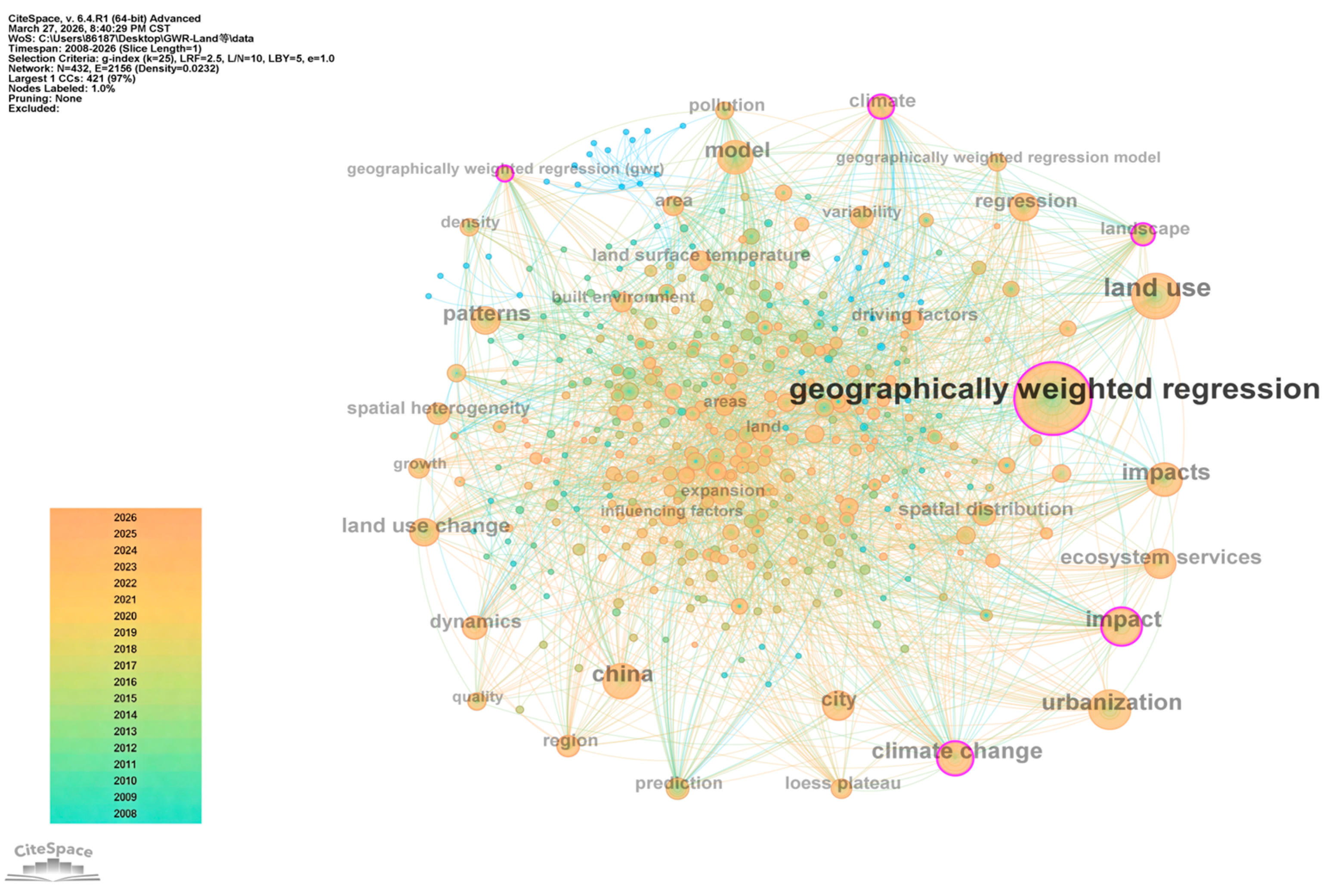
The keyword co-occurrence network further consolidates three core thematic clusters that define the global intellectual structure of applied GWR/MGWR research (Figure 8) [7,74,75]: (1) land-use change and multiscale driving forces; (2) infrastructure matching and public service equity; (3) environmental assessment and ecological carrying capacity. The central node remains “geographically weighted regression,” with strong links to “urbanization,” “land use change,” “spatial heterogeneity,” and “China,” which is consistent with global publication patterns and collaborative networks. The density of connections indicates high integration between methodology and real-world problem solving, especially in rapidly urbanizing regions. Over time, research themes have shifted from pure methodological exploration to scenario-based application, policy evaluation, and sustainable development goal assessment.
Node size indicates frequency, and link thickness indicates co-occurrence strength. Three clusters correspond to the three application subsections in this section, ensuring thematic consistency and logical coherence [7,74,75]. The evolutionary path indicated by the network also confirms the transition from model improvement to practical problem solving, which aligns with the three-stage development of GWR revealed in the bibliometric analysis.
Together, the global distribution and thematic structure highlight a critical trend: GWR/MGWR has evolved from a niche spatial statistical tool into a mainstream, policy-relevant approach for land, resource, and environmental governance [13,74]. The regional imbalance also points to a key future direction: expanding applications in underrepresented regions and strengthening international collaboration to improve the generalizability of findings beyond East Asia and North America [9,74,75]. Such efforts will help transform region-specific experiences into globally generalizable theories and methods for sustainable spatial management.

5.2. Applications in Land-Use Change and Multiscale Driving Mechanisms

Land-use change is the most mature and policy-relevant application of GWR/MGWR, with a three-decade intellectual trajectory from exploratory mapping to rigorous multiscale inference [2,3,13]. The core strength of these models lies in capturing spatially nonstationary and multiscale driving forces that global regression models and conventional spatial econometric models cannot resolve without introducing unacceptable bias [15,22,34]. Standard GWR identifies local variations in driver intensity and spatial pattern stability, while MGWR further separates regional-scale processes (e.g., economic growth, population migration) from neighborhood-scale factors (e.g., road access, planning boundaries) by allowing covariate-specific bandwidths [3,15,22]. This multiscale decomposition has revolutionized the interpretation of land transitions by aligning statistical estimates with real geographic processes [13,74].
In urban expansion and rural–urban land conversion, MGWR has become the dominant analytical approach in high-impact land systems research [3,13,15]. For instance, MGWR applied in the Pearl River Delta reveals that migration drives regional land expansion, whereas transportation and public services shape local conversion patterns with distinct spatial scales [13]. Similar findings in U.S. suburban areas confirm that MGWR outperforms GWR and spatial econometric models in distinguishing multiscale development pressures and reducing estimation bias [2,4]. In farmland protection and ecological land change, GWR/MGWR detects spatially varying impacts of economic development, urban sprawl, and agricultural policies, supporting targeted conservation strategies and zoning management [6,9]. These applications demonstrate that local coefficient surfaces provide actionable information for land planners that global coefficients simply cannot match [15,22].
Compared with global regression, GWR/MGWR reduces model misspecification bias and improves interpretability by honoring the first law of geography and relaxing the unrealistic global stationarity assumption [2,7,34]. Empirical studies across Asia, North America, Europe, and Australia confirm that multiscale models yield more realistic, reproducible, and policy-useful estimates of land transitions [6,9,74]. By quantifying how and why drivers vary across space, GWR/MGWR has become an indispensable tool in land-use planning, territorial spatial governance, and sustainability science [13,15]. Its wide adoption in land system studies also validates the practical value of methodological advances reviewed in Section 4, especially the breakthrough from single-bandwidth GWR to multiscale MGWR [3,15,22].

5.3. Applications in Infrastructure Matching and Spatial Resource Allocation

GWR/MGWR excels at quantifying spatial mismatches between population demand (especially migration-driven demand) and infrastructure supply, supporting equitable and efficient resource allocation in rapidly urbanizing regions [76,77,78,79]. Applications cover transportation, education, healthcare, water, energy, and public services, with a consistent focus on spatially varying accessibility, equity, and multiscale governance [15,22,34]. Unlike traditional accessibility models that produce global averages, GWR/MGWRs estimate location-specific effects and identifies underserved localities, enabling targeted investment and place-based policy design [9,13]. This capability is especially valuable in regions facing large-scale population mobility and unbalanced spatial development.
In public service infrastructure, GWR/MGWR identifies local deficits and heterogeneous driving factors that shape spatial equity [1,9,74]. Studies in fast-growing cities show that migrant concentration and neighborhood accessibility strongly predict gaps in education and healthcare access, which global models systematically overlook [9,13]. MGWR further disentangles regional drivers (e.g., fiscal investment, urban hierarchy) from local drivers (e.g., road density, community density), enabling a two-tier optimization framework: regional balancing and local supplementation [15,22]. This integrated approach has been widely adopted in urban master planning and public facility layout optimization [1,74]. By revealing spatial inequalities, GWR/MGWR provides a scientific basis for inclusive infrastructure development and balanced regional growth [9,13].
In water and energy resource management, GWR/MGWR links resource stress to migration agglomeration and infrastructure capacity across nested spatial scales [1,15,34]. Coastal urban regions in Spain and China show that water scarcity and energy carrying capacity exhibit strong spatial nonstationarity, with migrant density operating at broader scales and infrastructure operating locally [9,74]. Such results directly inform sustainable resource governance, infrastructure investment prioritization, and disaster risk reduction in water-scarce and energy-intensive regions [1,34]. By revealing scale-dependent relationships, GWR/MGWR helps policymakers avoid one-size-fits-all strategies and design adaptive resource allocation systems that balance development and protection [15,22].

5.4. Applications in Environmental Assessment and Integrated Framework Comparison

GWR/MGWR is widely used to map spatially varying environmental impacts, including air and water pollution, urban heat islands, ecological carrying capacity, and environmental injustice [5,6,14]. It reveals local hotspots and scale-dependent mechanisms that support precision environmental governance, evidence-based regulation, and inclusive sustainability policy [15,22,34]. By quantifying local variation in exposure and vulnerability, this model moves beyond aggregate environmental assessment to place-specific, human-centered analysis [9,74]. This aligns with global trends toward refined environmental management and targeted ecological restoration [6,14].
In pollution and ecological impact studies, MGWR differentiates regional drivers (e.g., industrial structure, climate) from local drivers (e.g., traffic emissions, green space configuration) with unprecedented clarity [3,15,22]. Applications in China and the EU show that infrastructure development intensifies haze pollution and ecological pressure unevenly, with stronger effects in migrant-receiving regions and urban peripheries [6,14]. In environmental justice, GWR detects disproportionate pollution exposure in low-income and migrant neighborhoods, providing rigorous empirical evidence for inclusive environmental policy and equitable development [9,74]. These applications highlight the unique ability of GWR/MGWR to combine statistical rigor with social and environmental relevance [1,34].
To guide model selection and support reproducible research, Table 3 compares GWR class models across scale, spatiotemporal capacity, inference, computation, and suitability for migration–infrastructure–land–environment systems [3,15,22].
This integrated framework and model comparison confirm that GWR/MGWR turn descriptive mapping into explanatory and policy-relevant science [80,81,82]. While challenges remain in local collinearity, computational scalability, and causal identification—as emphasized in Section 4—these models have become standard, irreplaceable tools for land, resource, and environmental research globally [5,14,34]. Moving forward, the integration of generalized models, spatiotemporal extensions, and high-performance computing will further expand their capacity to address complex, dynamic, and large-scale environmental challenges worldwide [1,15,34].

6. Directions for Future Research

Based on the comprehensive bibliometric and methodological review conducted in this study, together with the clustering results and evolutionary trends identified in the knowledge mapping analysis, several critical research gaps and under-explored directions remain for GWR/MGWR models in land systems, resource management, and environmental governance. These gaps are consistent with the weak points detected in keyword bursts, co-citation clusters, and application distributions, and can serve as clear frontiers for future investigations [6,83,84,85,86].
In addition, existing GWR-family models exhibit notable parameter sensitivity, particularly regarding bandwidth selection, spatial weighting function specification, and local multicollinearity. Improper choices can lead to unstable coefficient estimates, spatial overfitting, and unreliable identification of spatial heterogeneity, which may result in biased interpretation and misleading policy implications. These sensitivity issues and potential misinterpretation risks have not been systematically addressed in current reviews and warrant explicit attention in future methodological and applied research.
(1)
Unified multiscale–spatiotemporal inference frameworks require further development. Most existing GWR and MGWR applications treat spatial heterogeneity, temporal dynamics, and multiscale processes as separate components. In real-world land systems, however, urban expansion, infrastructure allocation, land-use conversion, and environmental responses are tightly coupled spatiotemporal processes that operate across nested spatial scales. Few integrated models can simultaneously estimate covariate-specific scales, time-varying local coefficients, and statistically consistent inference [54,87]. Future studies are encouraged to develop generalized multiscale–spatiotemporal models that support formal statistical testing, uncertainty partitioning, and dynamic scenario simulation for long-term panel data in land and environmental studies.
(2)
Robust statistical inference and uncertainty quantification need to be standardized. Although MGWR has significantly improved the interpretability of local parameter estimates, formal hypothesis testing, confidence interval construction, multiple-testing correction, and uncertainty decomposition remain insufficiently standardized for multiscale and spatiotemporal GWR models. Uncertainties induced by kernel function selection, bandwidth optimization, local multicollinearity, sampling design, and spatial autocorrelation are rarely quantified systematically [51,52]. Future research should establish unified diagnostic workflows, inference procedures, and uncertainty evaluation protocols to improve the reliability, comparability, and reproducibility of empirical results across land-use and environmental applications.
(3)
Computational scalability for large-scale and high-dimensional spatial big data must be enhanced. Modern land monitoring and urban analytics produce massive volumes of high-resolution spatial–temporal data. Conventional MGWR and MGTWR implementations rely on dense matrix operations and iterative backfitting, which lead to prohibitive computational costs for large samples and fine-grained grids. Further advances in GPU acceleration, parallel computing, sparse matrix techniques, and low-rank approximation are urgently needed [6,19]. Improving computational efficiency will enable broader application of GWR-family models in national-scale land mapping, real-time spatial governance, and high-dimensional geographic data analysis. Furthermore, integrating GWR/MGWR with machine learning and deep learning methods (e.g., random forest, CNN, LSTM) can effectively enhance model prediction accuracy and computational efficiency while retaining partial interpretability, thus improving overall performance in complex spatial data scenarios.
(4)
Causal interpretation and policy-oriented applications remain limited. Most current GWR/MGWR studies focus on spatial correlation and heterogeneity description rather than causal identification. Few studies integrate GWR/MGWR with instrumental variables, regression discontinuity, difference-in-differences, or causal mediation analysis to identify causal effects in land-use change, infrastructure investment, and environmental policy evaluation [1,13,34]. To strengthen causal identification, GWR/MGWR can be integrated with mainstream causal inference tools such as instrumental variables (IV), difference-in-differences (DID), and regression discontinuity (RD). Such integration can help identify spatially heterogeneous policy effects and improve the causal interpretability and policy guidance of GWR-based models. Future work is expected to strengthen causal interpretability, quantify spatially heterogeneous policy effects, and support place-based governance for sustainable land use, inclusive infrastructure development, and environmental justice.
(5)
Generalized and nonlinear extensions for non-Gaussian land and environmental data require expansion. A considerable share of land and environmental variables are discrete, categorical, overdispersed, or limited (e.g., count, binary, proportion). Although Generalized GWR models have been proposed, their multiscale and spatiotemporal versions remain underdeveloped [15,16]. Expanding generalized MGWR and generalized GTWR to non-Gaussian data structures will further broaden the applicability of GWR methods in disaster monitoring, ecological risk assessment, disease mapping, and land-use intensity analysis.

7. Conclusions

Along with the continuous advancement of spatial data science and global urbanization, the demand for refined spatial analysis in land systems, resource allocation, infrastructure governance, and environmental assessment has increased substantially. As effective tools for capturing spatial nonstationarity and multiscale heterogeneity, GWR MGWR have been increasingly adopted in geographic, urban, and environmental research, and a large number of theoretical and empirical studies have been conducted [2,7,22]. This paper summarizes and analyzes the global literature on GWR/MGWR from 1996 to 2025, to clarify the evolutionary phases, knowledge structure, methodological advances, application hotspots, and future trends. Bibliometrics and CiteSpace software are used to visually analyze 1000 carefully selected high-quality articles, including publication outputs, countries, institutions, authors, keywords, co-citation networks, and clustering structures [9,14]. The results show that global GWR/MGWR research has experienced three developmental phases: conceptual emergence, methodological takeoff, and multiscale–computational maturity. The field is dominated by China, the United States, the United Kingdom, and Australia, with a dual-center structure of theoretical innovation and large-scale empirical application. Keyword and co-citation clustering identify six core themes: standard GWR, bandwidth optimization, GTWR, MGWR, Generalized GWR, and GWR–machine learning integration. Current applications focus heavily on spatial heterogeneity, multiscale driving forces, land-use change, infrastructure matching, resource allocation, and environmental impact assessment.
Despite remarkable progress, several key challenges remain, including the lack of unified multiscale–spatiotemporal inference, insufficient statistical uncertainty quantification, limited computational scalability, weak causal interpretation, and inadequate extensions for non-Gaussian data. Potential future directions are also proposed, including integrated spatiotemporal–multiscale modeling, robust inference and uncertainty analysis, high-performance computing, causal spatial regression, and generalized nonlinear models. The findings of this study can help researchers comprehensively understand the intellectual landscape, current advances, and prospective directions of GWR/MGWR research. Furthermore, practitioners can be guided to conduct more rigorous and targeted spatial analysis in land management, infrastructure planning, and environmental governance. The results can also provide reference for governments and planning agencies to formulate evidence-based and spatially refined policies for sustainable land-use development, balanced resource allocation, and ecological conservation.

Supplementary Materials

The following supporting information can be downloaded at: https://www.mdpi.com/article/10.3390/land15060915/s1. Reference [88] is cited in Supplementary Materials.

Author Contributions

Writing—original draft, R.Y., W.Y. and H.Y.; writing—review and editing, T.S. All authors have read and agreed to the published version of the manuscript.

Funding

This research was funded by the Beijing Social Science Fund Major Project (Grant No. 24JCA003), awarded by the Beijing Federation of Social Science Circles and Beijing Philosophy and Social Science Planning Office.

Data Availability Statement

Data is available for use upon request.

Conflicts of Interest

The authors declare no conflicts of interest.

References

  1. Anselin, L. Spatial econometrics. In Handbook of Spatial Analysis in the Social Sciences; Edward Elgar Publishing: Cheltenham, UK, 2022; pp. 101–122. [Google Scholar]
  2. Brunsdon, C.; Fotheringham, A.S.; Charlton, M.E. Geographically weighted regression: A method for exploring spatial nonstationarity. Geogr. Anal. 1996, 28, 281–298. [Google Scholar] [CrossRef]
  3. Fotheringham, S.; Brundson, C.; Charlton, M. Geographically Weighted Regression & Associated Techniques; Wiley: Hoboken, NJ, USA, 2002. [Google Scholar]
  4. Chi, G.; Zhu, J. Spatial regression models for demographic analysis. Popul. Res. Policy Rev. 2008, 27, 17–42. [Google Scholar] [CrossRef]
  5. Fischer, M.M.; Getis, A. Handbook of Applied Spatial Analysis: Software Tools, Methods and Applications; Springer: Berlin/Heidelberg, Germany, 2010. [Google Scholar]
  6. Fotheringham, A.S.; Yang, W.; Kang, W. Multiscale geographically weighted regression (MGWR). Ann. Am. Assoc. Geogr. 2017, 107, 1247–1265. [Google Scholar] [CrossRef]
  7. Fotheringham, A.S.; Charlton, M.E.; Brunsdon, C. Geographically weighted regression: A natural evolution of the expansion method for spatial data analysis. Environ. Plan. A 1998, 30, 1905–1927. [Google Scholar] [CrossRef]
  8. Oshan, T.M.; Li, Z.; Kang, W.; Wolf, L.J.; Fotheringham, A.S. mgwr: A Python implementation of multiscale geographically weighted regression for investigating process spatial heterogeneity and scale. ISPRS Int. J. Geo-Inf. 2019, 8, 269. [Google Scholar] [CrossRef]
  9. Finley, A.O. Comparing spatially-varying coefficients models for analysis of ecological data with non-stationary and anisotropic residual dependence. Methods Ecol. Evol. 2011, 2, 143–154. [Google Scholar] [CrossRef]
  10. Comber, A.; Brunsdon, C.; Charlton, M.; Dong, G.; Harris, R.; Lu, B.; Lü, Y.; Murakami, D.; Nakaya, T.; Wang, Y. The GWR route map: A guide to the informed application of Geographically Weighted Regression. arXiv 2020, arXiv:2004.06070. [Google Scholar] [CrossRef]
  11. Wheeler, D.C. Diagnostic tools and a remedial method for collinearity in geographically weighted regression. Environ. Plan. A 2007, 39, 2464–2481. [Google Scholar] [CrossRef]
  12. Wheeler, D.C. Simultaneous coefficient penalization and model selection in geographically weighted regression: The geographically weighted lasso. Environ. Plan. A 2009, 41, 722–742. [Google Scholar] [CrossRef]
  13. Li, S.; Zhou, C.; Wang, S.; Gao, S.; Liu, Z. Spatial heterogeneity in the determinants of urban form: An analysis of Chinese cities with a GWR approach. Sustainability 2019, 11, 479. [Google Scholar] [CrossRef]
  14. Wang, C.; Du, S.; Wen, J.; Zhang, M.; Gu, H.; Shi, Y.; Xu, H. Analyzing explanatory factors of urban pluvial floods in Shanghai using geographically weighted regression. Stoch. Environ. Res. Risk Assess. 2017, 31, 1777–1790. [Google Scholar] [CrossRef]
  15. Xu, G.; Jiang, Y.; Wang, S.; Qin, K.; Ding, J.; Liu, Y.; Lu, B. Spatial disparities of self-reported COVID-19 cases and influencing factors in Wuhan, China. Sustain. Cities Soc. 2022, 76, 103485. [Google Scholar] [CrossRef] [PubMed]
  16. Yu, H. Exploring multiscale spatial interactions: Multiscale geographically weighted negative binomial regression. Ann. Am. Assoc. Geogr. 2024, 114, 574–590. [Google Scholar] [CrossRef]
  17. Liu, Y.; Goudie, R.J. Generalized geographically weighted regression model within a modularized Bayesian framework. Bayesian Anal. 2023, 19, 465. [Google Scholar] [CrossRef] [PubMed]
  18. Shahneh, M.R.; Oymak, S.; Magdy, A. A-gwr: Fast and accurate geospatial inference via augmented geographically weighted regression. In Proceedings of the 29th International Conference on Advances in Geographic Information Systems; ACM: New York, NY, USA, 2021. [Google Scholar]
  19. Wang, D.; Yang, Y.; Qiu, A.; Kang, X.; Han, J.; Chai, Z. A CUDA-based parallel geographically weighted regression for large-scale geographic data. ISPRS Int. J. Geo-Inf. 2020, 9, 653. [Google Scholar] [CrossRef]
  20. Li, Z.; Fotheringham, A.S.; Oshan, T.M.; Wolf, L.J. Measuring bandwidth uncertainty in multiscale geographically weighted regression using Akaike weights. Ann. Am. Assoc. Geogr. 2020, 110, 1500–1520. [Google Scholar] [CrossRef]
  21. Comber, A.; Brunsdon, C.; Charlton, M.; Dong, G.; Harris, R.; Lu, B.; Lü, Y.; Murakami, D.; Nakaya, T.; Wang, Y. A route map for successful applications of geographically weighted regression. Geogr. Anal. 2023, 55, 155–178. [Google Scholar] [CrossRef]
  22. Foody, G.M. Spatial nonstationarity and scale-dependency in the relationship between species richness and environmental determinants for the sub-Saharan endemic avifauna. Glob. Ecol. Biogeogr. 2004, 13, 315–320. [Google Scholar] [CrossRef]
  23. Chen, Y.; Chen, C.; Liu, Z.; Hu, Z.; Wang, X. The methodology function of CiteSpace mapping knowledge domains. Stud. Sci. Sci. 2015, 33, 242–253. [Google Scholar]
  24. Guo, P.; Tian, W.; Li, H.; Zhang, G.; Li, J. Global characteristics and trends of research on construction dust: Based on bibliometric and visualized analysis. Environ. Sci. Pollut. Res. 2020, 27, 37773–37789. [Google Scholar] [CrossRef]
  25. Zhong, B.; Wu, H.; Li, H.; Sepasgozar, S.; Luo, H.; He, L. A scientometric analysis and critical review of construction related ontology research. Autom. Constr. 2019, 101, 17–31. [Google Scholar] [CrossRef]
  26. Zhang, D.; Xu, J.; Zhang, Y.; Wang, J.; He, S.; Zhou, X. Study on sustainable urbanization literature based on Web of Science, scopus, and China national knowledge infrastructure: A scientometric analysis in CiteSpace. J. Clean. Prod. 2020, 264, 121537. [Google Scholar] [CrossRef]
  27. Zhao, X.; Zuo, J.; Wu, G.; Huang, C. A bibliometric review of green building research 2000–2016. Archit. Sci. Rev. 2019, 62, 74–88. [Google Scholar] [CrossRef]
  28. Darko, A.; Chan, A.P.; Huo, X.; Owusu-Manu, D.-G. A scientometric analysis and visualization of global green building research. Build. Environ. 2019, 149, 501–511. [Google Scholar] [CrossRef]
  29. Liu, Y.; Sun, T.; Yang, L. Evaluating the performance and intellectual structure of construction and demolition waste research during 2000–2016. Environ. Sci. Pollut. Res. 2017, 24, 19259–19266. [Google Scholar] [CrossRef]
  30. Li, Y.; Li, M.; Sang, P. A bibliometric review of studies on construction and demolition waste management by using CiteSpace. Energy Build. 2022, 258, 111822. [Google Scholar] [CrossRef]
  31. Wu, Z.; Ann, T.; Shen, L.; Liu, G. Quantifying construction and demolition waste: An analytical review. Waste Manag. 2014, 34, 1683–1692. [Google Scholar] [CrossRef]
  32. Yuan, H.; Shen, L. Trend of the research on construction and demolition waste management. Waste Manag. 2011, 31, 670–679. [Google Scholar] [CrossRef] [PubMed]
  33. Li, Y.; Song, H.; Sang, P.; Chen, P.-H.; Liu, X. Review of Critical Success Factors (CSFs) for green building projects. Build. Environ. 2019, 158, 182–191. [Google Scholar] [CrossRef]
  34. Tobler, W.R. A computer movie simulating urban growth in the Detroit region. Econ. Geogr. 1970, 46, 234–240. [Google Scholar] [CrossRef] [PubMed]
  35. Cochran, K.; Townsend, T.G. Estimating construction and demolition debris generation using a materials flow analysis approach. Waste Manag. 2010, 30, 2247–2254. [Google Scholar] [CrossRef] [PubMed]
  36. Paz, D.H.F.d.; Lafayette, K.P.V.; Sobral, M.d.C. GIS-based planning system for managing the flow of construction and demolition waste in Brazil. Waste Manag. Res. 2018, 36, 541–549. [Google Scholar] [CrossRef] [PubMed]
  37. Hsiao, T.-Y.; Yu, Y.-H.; Chang, I.-C. Material flows analysis of construction aggregates in Taiwan. Prog. Ind. Ecol. Int. J. 2009, 6, 135–152. [Google Scholar] [CrossRef]
  38. Zambrana-Vasquez, D.; Zabalza-Bribián, I.; Jáñez, A.; Aranda-Usón, A. Analysis of the environmental performance of life-cycle building waste management strategies in tertiary buildings. J. Clean. Prod. 2016, 130, 143–154. [Google Scholar] [CrossRef]
  39. Yellow Horse, A.J.; Yang, T.-C.; Huyser, K.R. Structural inequalities established the architecture for COVID-19 pandemic among native Americans in Arizona: A geographically weighted regression perspective. J. Racial Ethn. Health Disparities 2022, 9, 165–175. [Google Scholar] [CrossRef] [PubMed]
  40. Mohebbi, A.; Yu, F.; Cai, S.; Akbariyeh, S.; Smaglik, E.J. Spatial study of particulate matter distribution, based on climatic indicators during major dust storms in the State of Arizona. Front. Earth Sci. 2021, 15, 133–150. [Google Scholar] [CrossRef]
  41. Wang, S.; Fang, C.; Ma, H.; Wang, Y.; Qin, J. Spatial differences and multi-mechanism of carbon footprint based on GWR model in provincial China. J. Geogr. Sci. 2014, 24, 612–630. [Google Scholar] [CrossRef]
  42. Zhou, Q.; Wang, C.; Fang, S. Application of geographically weighted regression (GWR) in the analysis of the cause of haze pollution in China. Atmos. Pollut. Res. 2019, 10, 835–846. [Google Scholar] [CrossRef]
  43. Ajayi, S.O.; Oyedele, L.O. Waste-efficient materials procurement for construction projects: A structural equation modelling of critical success factors. Waste Manag. 2018, 75, 60–69. [Google Scholar] [CrossRef] [PubMed]
  44. Ajayi, S.O.; Oyedele, L.O.; Akinade, O.O.; Bilal, M.; Alaka, H.A.; Owolabi, H.A. Optimising material procurement for construction waste minimization: An exploration of success factors. Sustain. Mater. Technol. 2017, 11, 38–46. [Google Scholar] [CrossRef]
  45. Li, W.; Arundel, S.; Gao, S.; Goodchild, M.; Hu, Y.; Wang, S.; Zipf, A. GeoAI for Science and the Science of GeoAI. J. Spat. Inf. Sci. 2024, 29, 1–17. [Google Scholar] [CrossRef]
  46. Li, W.; Hsu, C.-Y.; Wang, S.; Kedron, P. GeoAI Reproducibility and Replicability: A computational and spatial perspective. Ann. Am. Assoc. Geogr. 2024, 114, 2085–2103. [Google Scholar] [CrossRef]
  47. Zhu, D.; Liu, Y.; Yao, X.; Fischer, M.M. Spatial regression graph convolutional neural networks: A deep learning paradigm for spatial multivariate distributions. GeoInformatica 2022, 26, 645–676. [Google Scholar] [CrossRef]
  48. Du, Z.; Wang, Z.; Wu, S.; Zhang, F.; Liu, R. Geographically neural network weighted regression for the accurate estimation of spatial non-stationarity. Int. J. Geogr. Inf. Sci. 2020, 34, 1353–1377. [Google Scholar] [CrossRef]
  49. Windle, M.J.; Rose, G.A.; Devillers, R.; Fortin, M.-J. Exploring spatial non-stationarity of fisheries survey data using geographically weighted regression (GWR): An example from the Northwest Atlantic. ICES J. Mar. Sci. 2010, 67, 145–154. [Google Scholar] [CrossRef]
  50. Kupfer, J.A.; Farris, C.A. Incorporating spatial non-stationarity of regression coefficients into predictive vegetation models. Landsc. Ecol. 2007, 22, 837–852. [Google Scholar] [CrossRef]
  51. da Silva, A.R.; Fotheringham, A.S. The multiple testing issue in geographically weighted regression. Geogr. Anal. 2016, 48, 233–247. [Google Scholar] [CrossRef]
  52. Yu, H.; Fotheringham, A.S.; Li, Z.; Oshan, T.; Kang, W.; Wolf, L.J. Inference in multiscale geographically weighted regression. Geogr. Anal. 2020, 52, 87–106. [Google Scholar] [CrossRef]
  53. Wu, C.; Ren, F.; Hu, W.; Du, Q. Multiscale geographically and temporally weighted regression: Exploring the spatiotemporal determinants of housing prices. Int. J. Geogr. Inf. Sci. 2019, 33, 489–511. [Google Scholar] [CrossRef]
  54. Yu, H. Generalized geographically and temporally weighted regression. Comput. Environ. Urban Syst. 2025, 117, 102244. [Google Scholar] [CrossRef]
  55. Yu, H.; Fotheringham, A.S. On the calibration of multiscale geographically and temporally weighted regression models. Int. J. Geogr. Inf. Sci. 2025, 39, 1203–1222. [Google Scholar] [CrossRef]
  56. Hong, Z.; Wang, R.; Wang, Z.; Du, W. Inference issue in multiscale geographically and temporally weighted regression. Stat. Comput. 2025, 35, 30. [Google Scholar] [CrossRef]
  57. Song, W.; Jia, H.; Li, Z.; Tang, D.; Wang, C. Detecting urban land-use configuration effects on NO2 and NO variations using geographically weighted land use regression. Atmos. Environ. 2019, 197, 166–176. [Google Scholar] [CrossRef]
  58. Liu, J.; Zhao, Y.; Yang, Y.; Xu, S.; Zhang, F.; Zhang, X.; Shi, L.; Qiu, A. A mixed geographically and temporally weighted regression: Exploring spatial-temporal variations from global and local perspectives. Entropy 2017, 19, 53. [Google Scholar] [CrossRef]
  59. Zhang, Z.; Li, J.; Fung, T.; Yu, H.; Mei, C.; Leung, Y.; Zhou, Y. Multiscale geographically and temporally weighted regression with a unilateral temporal weighting scheme and its application in the analysis of spatiotemporal characteristics of house prices in Beijing. Int. J. Geogr. Inf. Sci. 2021, 35, 2262–2286. [Google Scholar] [CrossRef]
  60. Akinwumiju, A.S.; Oluwafemi, O.; Mohammed, Y.D.; Mobolaji, J.W. Geospatial evaluation of COVID-19 mortality: Influence of socio-economic status and underlying health conditions in contiguous USA. Appl. Geogr. 2022, 141, 102671. [Google Scholar] [CrossRef]
  61. Luo, Y.; Yan, J.; McClure, S.C.; Li, F. Socioeconomic and environmental factors of poverty in China using geographically weighted random forest regression model. Environ. Sci. Pollut. Res. 2022, 29, 33205–33217. [Google Scholar] [CrossRef]
  62. Subedi, N.; Zhang, L.; Zhen, Z. Bayesian geographically weighted regression and its application for local modeling of relationships between tree variables. iForest-Biogeosci. For. 2018, 11, 542. [Google Scholar] [CrossRef]
  63. Ma, Z.; Xue, Y.; Hu, G. Geographically weighted regression analysis for spatial economics data: A Bayesian recourse. Int. Reg. Sci. Rev. 2021, 44, 582–604. [Google Scholar] [CrossRef]
  64. Chen, F.; Leung, Y.; Mei, C.L.; Fung, T. Backfitting estimation for geographically weighted regression models with spatial autocorrelation in the response. Geogr. Anal. 2022, 54, 357–381. [Google Scholar] [CrossRef]
  65. Kagoyire, C. Multiscale Spatial Modelling to Support Targeting of Childhood Stunting in Rwanda: From Kernel-Weighted Local Models to Neural Network-Learned Locality. Doctoral Dissertation, Lund University, Lund, Sweden, 2026. [Google Scholar]
  66. Harris, P.; Brunsdon, C.; Fotheringham, A.S. Links, comparisons and extensions of the geographically weighted regression model when used as a spatial predictor. Stoch. Environ. Res. Risk Assess. 2011, 25, 123–138. [Google Scholar] [CrossRef]
  67. Nakaya, T.; Fotheringham, S.; Charlton, M.; Brunsdon, C. Semiparametric geographically weighted generalised linear modelling in GWR 4.0. In Proceedings of the 10th International Conference on GeoComputation; University of New South Wales (UNSW) Sydney: Sydney, Australia, 2014. [Google Scholar]
  68. Zhao, Q.; Fan, Q.; Zhou, P. An integrated analysis of GWR models and spatial econometric global models to decompose the driving forces of the township consumption development in Gansu, China. Sustainability 2021, 14, 281. [Google Scholar] [CrossRef]
  69. Yu, H.; Gong, H.; Chen, B.; Liu, K.; Gao, M. Analysis of the influence of groundwater on land subsidence in Beijing based on the geographical weighted regression (GWR) model. Sci. Total Environ. 2020, 738, 139405. [Google Scholar] [CrossRef]
  70. Kashki, A.; Karami, M.; Zandi, R.; Roki, Z. Evaluation of the effect of geographical parameters on the formation of the land surface temperature by applying OLS and GWR, A case study Shiraz City, Iran. Urban Clim. 2021, 37, 100832. [Google Scholar] [CrossRef]
  71. Liu, C.; Wu, X.; Wang, L. Analysis on land ecological security change and affect factors using RS and GWR in the Danjiangkou Reservoir area, China. Appl. Geogr. 2019, 105, 1–14. [Google Scholar] [CrossRef]
  72. Cao, X.; Liu, Y.; Li, T.; Liao, W. Analysis of spatial pattern evolution and influencing factors of regional land use efficiency in China based on ESDA-GWR. Sci. Rep. 2019, 9, 520. [Google Scholar] [CrossRef]
  73. Li, S.; Zhao, Z.; Miaomiao, X.; Wang, Y. Investigating spatial non-stationary and scale-dependent relationships between urban surface temperature and environmental factors using geographically weighted regression. Environ. Model. Softw. 2010, 25, 1789–1800. [Google Scholar] [CrossRef]
  74. Gollini, I.; Lu, B.; Charlton, M.; Brunsdon, C.; Harris, P. GWmodel: An R package for exploring spatial heterogeneity using geographically weighted models. J. Stat. Softw. 2015, 63, 1–50. [Google Scholar] [CrossRef]
  75. Páez, A.; Uchida, T.; Miyamoto, K. A general framework for estimation and inference of geographically weighted regression models: 1. Location-specific kernel bandwidths and a test for locational heterogeneity. Environ. Plan. A 2002, 34, 733–754. [Google Scholar] [CrossRef]
  76. Chen, J.; Lin, Z.; Li, L.-a.; Li, J.; Wang, Y.; Pan, Y.; Yang, J.; Xu, C.; Zeng, X.; Xie, X. Ten years of China’s new healthcare reform: A longitudinal study on changes in health resources. BMC Public Health 2021, 21, 2272. [Google Scholar] [CrossRef]
  77. Ming, L.; Chang, J.; Li, C.; Chen, Y.; Li, C. Spatial-temporal patterns of ecosystem services supply-demand and influencing factors: A case study of resource-based cities in the Yellow River Basin, China. Int. J. Environ. Res. Public Health 2022, 19, 16100. [Google Scholar] [CrossRef]
  78. Xia, H.; Guan, Y.; Pan, H.; Shen, Y. Spatial evolution and influencing factors of income gap in resource-based cities based on GWR. GeoJournal 2025, 90, 132. [Google Scholar] [CrossRef]
  79. Duan, J.; Zhao, Z.; Xu, Y.; You, X.; Yang, F.; Chen, G. Spatial distribution characteristics and driving factors of little giant enterprises in China’s megacity clusters based on random forest and MGWR. Land 2024, 13, 1105. [Google Scholar] [CrossRef]
  80. Longley, P.A.; Tobón, C. Spatial dependence and heterogeneity in patterns of hardship: An intra-urban analysis. Ann. Assoc. Am. Geogr. 2004, 94, 503–519. [Google Scholar] [CrossRef]
  81. Wang, F.; Liu, L. Computational Methods and GIS Applications in Social Science; CRC Press: Boca Raton, FL, USA, 2023. [Google Scholar]
  82. Wan, S.; Chen, Y.; Xiao, Y.; Zhao, Q.; Li, M.; Wu, S. Spatial analysis and evaluation of medical resource allocation in China based on geographic big data. BMC Health Serv. Res. 2021, 21, 1084. [Google Scholar] [CrossRef]
  83. Shabrina, Z.; Buyuklieva, B.; Ng, M.K.M. Short-term rental platform in the urban tourism context: A geographically weighted regression (GWR) and a multiscale GWR (MGWR) approaches. Geogr. Anal. 2021, 53, 686–707. [Google Scholar] [CrossRef]
  84. Lessani, M.N.; Li, Z. SGWR: Similarity and geographically weighted regression. Int. J. Geogr. Inf. Sci. 2024, 38, 1232–1255. [Google Scholar] [CrossRef]
  85. Murakami, D.; Tsutsumida, N.; Yoshida, T.; Nakaya, T.; Lu, B. Scalable GWR: A linear-time algorithm for large-scale geographically weighted regression with polynomial kernels. Ann. Am. Assoc. Geogr. 2020, 111, 459–480. [Google Scholar] [CrossRef]
  86. Fotheringham, A.S.; Crespo, R.; Yao, J. Geographical and temporal weighted regression (GTWR). Geogr. Anal. 2015, 47, 431–452. [Google Scholar] [CrossRef]
  87. Huang, B.; Wu, B.; Barry, M. Geographically and temporally weighted regression for modeling spatio-temporal variation in house prices. Int. J. Geogr. Inf. Sci. 2010, 24, 383–401. [Google Scholar] [CrossRef]
  88. Tricco, A.C.; Lillie, E.; Zarin, W.; O’Brien, K.K.; Colquhoun, H.; Levac, D.; Moher, D.; Peters, M.D.; Horsley, T.; Weeks, L.; et al. PRISMA Extension for Scoping Reviews (PRISMAScR): Checklist and Explanation. Ann. Intern. Med. 2018, 169, 467–473. [Google Scholar] [CrossRef] [PubMed]
Figure 1. Research framework.
Land 15 00915 g001
Figure 2. PRISMA-ScR flow diagram of study selection.
Land 15 00915 g002
Figure 3. Keyword co-occurrence network of global GWR research (2000–2026).
Land 15 00915 g003
Figure 4. Keyword co-occurrence clustering map of GWR research (2000–2026).
Land 15 00915 g004
Figure 5. Institutional collaboration network of global GWR research (2000–2024).
Land 15 00915 g005
Figure 6. Keyword timeline view of GWR research evolution (2000–2024).
Land 15 00915 g006
Figure 7. Top 25 keywords with the strongest citation bursts in GWR research (1990–2024).
Land 15 00915 g007
Figure 8. Keyword co-occurrence network of GWR applications in land, resources, and environment.
Land 15 00915 g008
Table 1. Comparison of GWR, MGWR, and classical spatial econometric models (SLM: Spatial Lag Model; SEM: Spatial Error Model).
Evaluation DimensionStd GWRMGWRGTWR/MGTWRGen GWRBayes GWRBayes ST-GWRGWR-MLSLM/SEM
Local
estimation
YesYesYesYesYesYesYesNo
Multiscale
capability
NoYesYesNoNoNoNoNo
Spatiotemporal adaptionNoNoYesYesNoYesYesNo
Statistical
inference
WeakStrongModerateModerateStrongStrongWeakStrong
Computational loadLowHighHighHighVery HighVery HighVery HighMedium/Low
Applicable
scenario
Exploratory
analysis
Multiscale modelingSpatiotemporal
research
Non-Gaussian dataSmall-sample analysisBayesian spatiotemporal studyHigh-dimensional modelingSpatial econometric analysis
Table 2. Applicable scenarios of major GWR extension models.
Model TypeSuitable DataKey StrengthMinimum Sample SizeTypical Scenarios
Standard GWRCross-sectional GaussianSimple, interpretable≥100Exploratory spatial analysis
MGWRCross-sectional GaussianMultiscale, inferential≥150Land use, infrastructure, environment
GTWR/MGTWRSpatiotemporal panelSpatiotemporally adaptive≥200Housing prices, pollution, urban expansion
Generalized GWRCount/binary/overdispersedNon-Gaussian support≥150Disease mapping, event counts
Bayesian GWRSmall/uncertain samplesUncertainty quantification≥50Sparse spatial data
GWR-ML HybridHigh-dimensional dataHigh prediction accuracy≥300Spatial prediction, big data
Table 3. Multiscale characteristics and GWR/MGWR modeling suitability in migration–infrastructure–land systems.
System ComponentSpatial ScaleKey HeterogeneitySuitable ModelCore Contribution to the Issue
Rural–urban migrationRegional → LocalSpatially uneven concentrationMGWRIdentify multiscale population pull effects
Urban infrastructureCity → NeighborhoodLocal supply–demand mismatchMGWRQuantify spatial inequity of public services
Land-use changeMetropolitan → PatchDivergent conversion driversMGWRReveal hotspots of urban expansion
Resource allocationBasin → CommunitySpatially mismatched carrying capacityGWR/MGTWROptimize water/energy allocation
Environmental impactRegional → BlockLocal pollution hotspotsMGWRSupport environmental justice policy
Disclaimer/Publisher’s Note: The statements, opinions and data contained in all publications are solely those of the individual author(s) and contributor(s) and not of MDPI and/or the editor(s). MDPI and/or the editor(s) disclaim responsibility for any injury to people or property resulting from any ideas, methods, instructions or products referred to in the content.