A Basin-Scale Framework for Identifying Hydro-Cultural Heritage Corridor Patterns and Guiding Graded Protection: Evidence from the Xiangjiang River Basin, China

Abstract
1. Introduction
2. Research Design
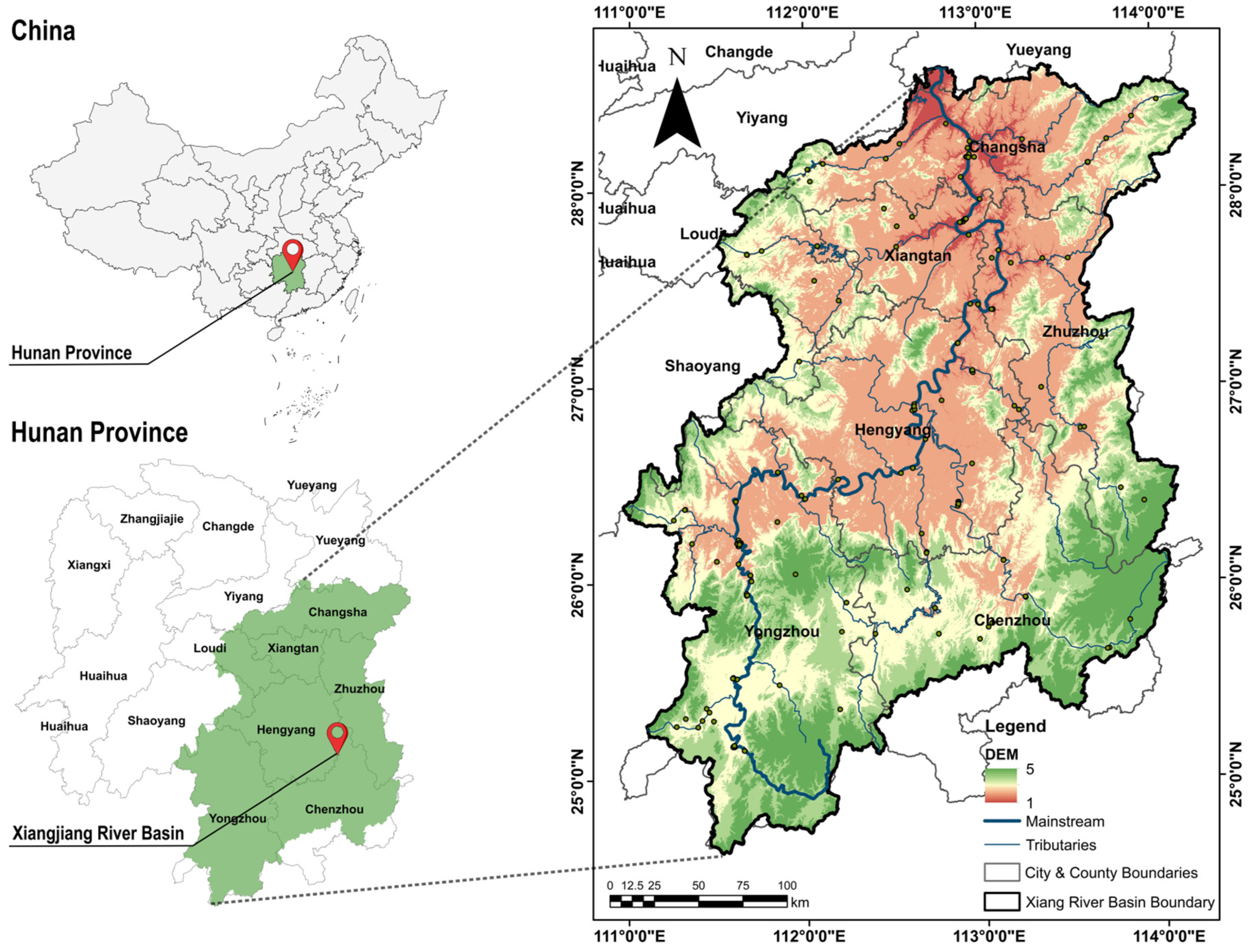
2.1. Study Area
2.2. Data Sources and Processing
2.2.1. Data Sources
2.2.2. Sample Selection and Preprocessing
2.3. Research Methodology
2.3.1. Heritage-Site Evaluation
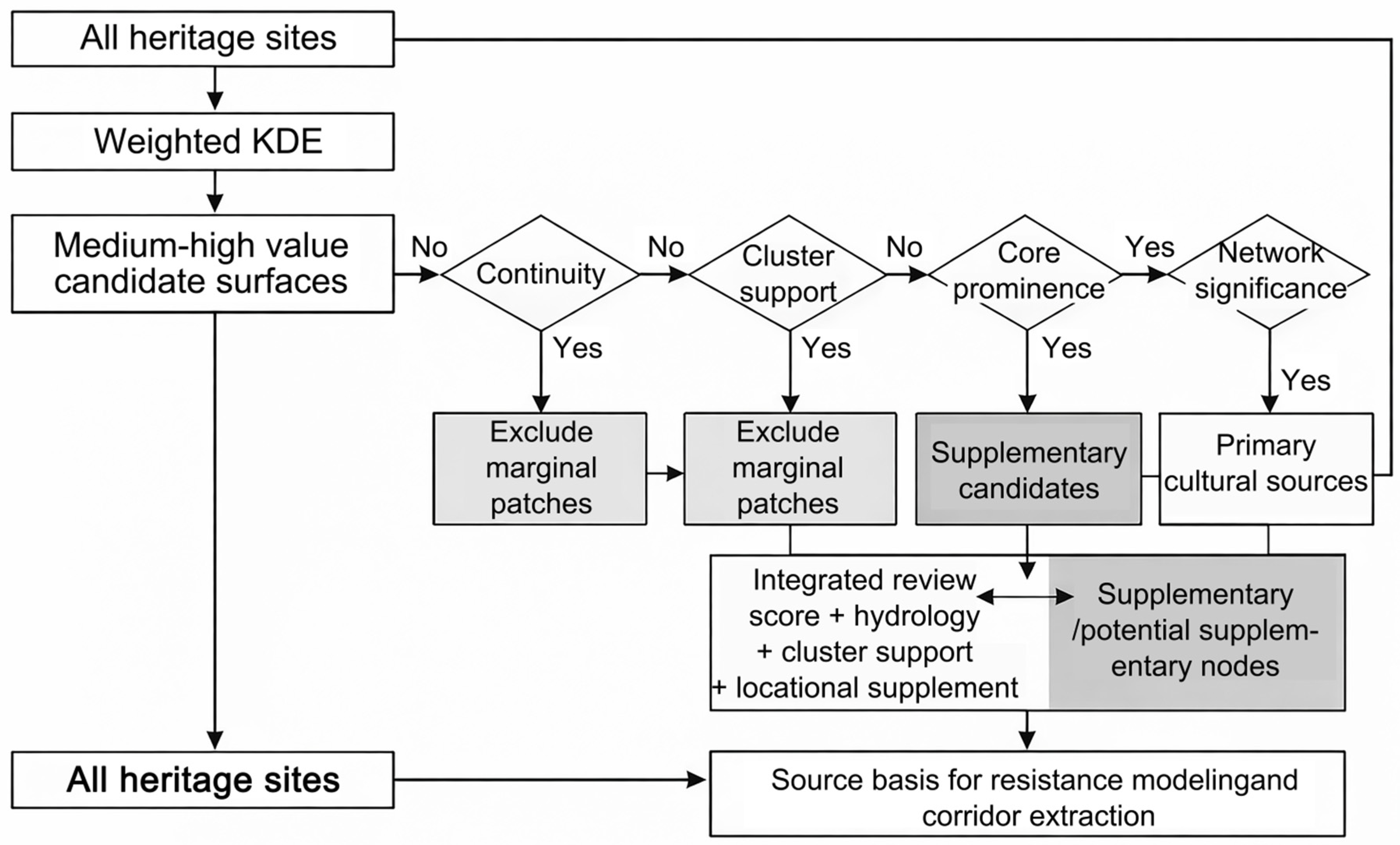
2.3.2. Cultural Source Identification
2.3.3. Comprehensive Resistance-Surface Construction and Potential Corridor Extraction
2.3.4. Corridor Grading and Network-Structure Validation
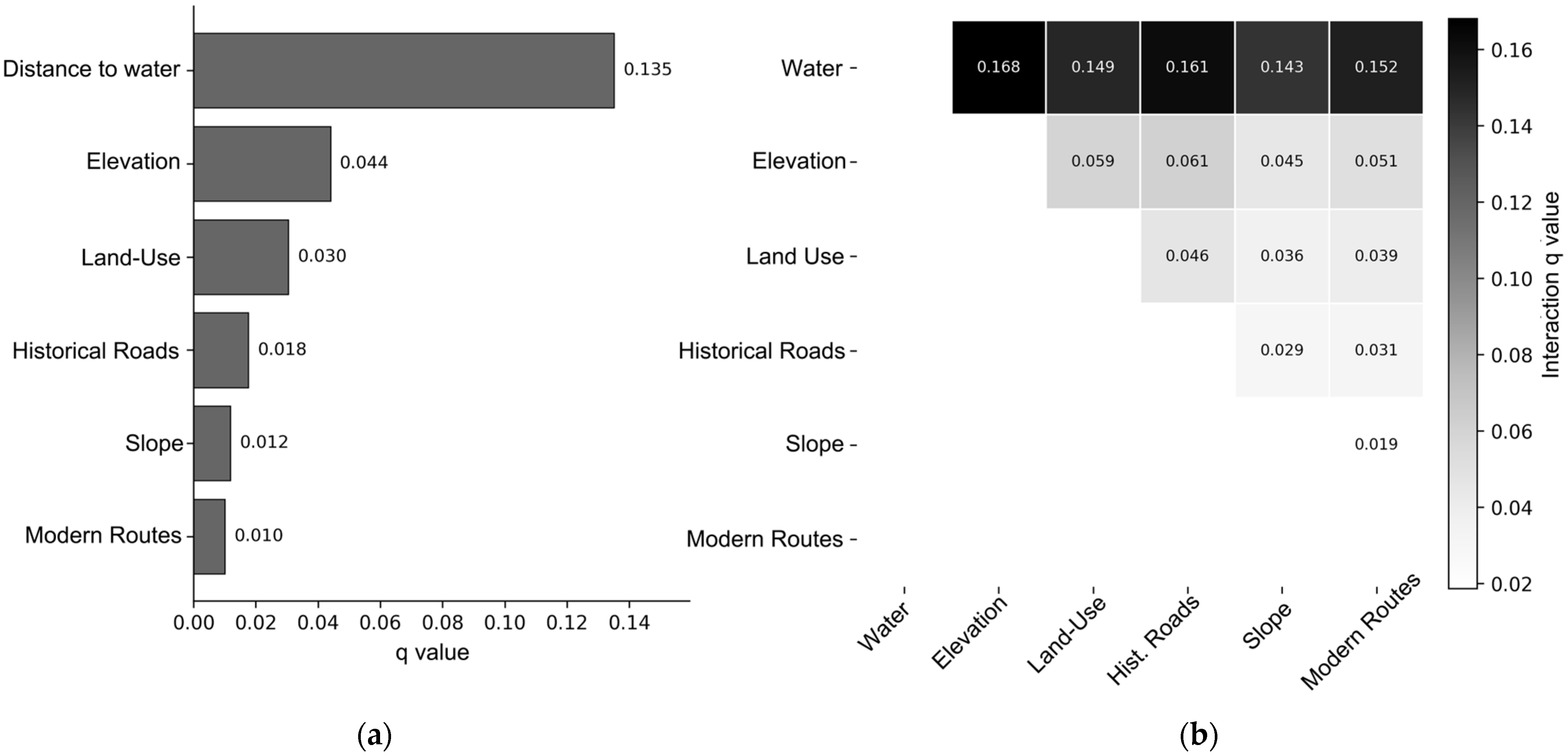
2.3.5. GeoDetector Analysis
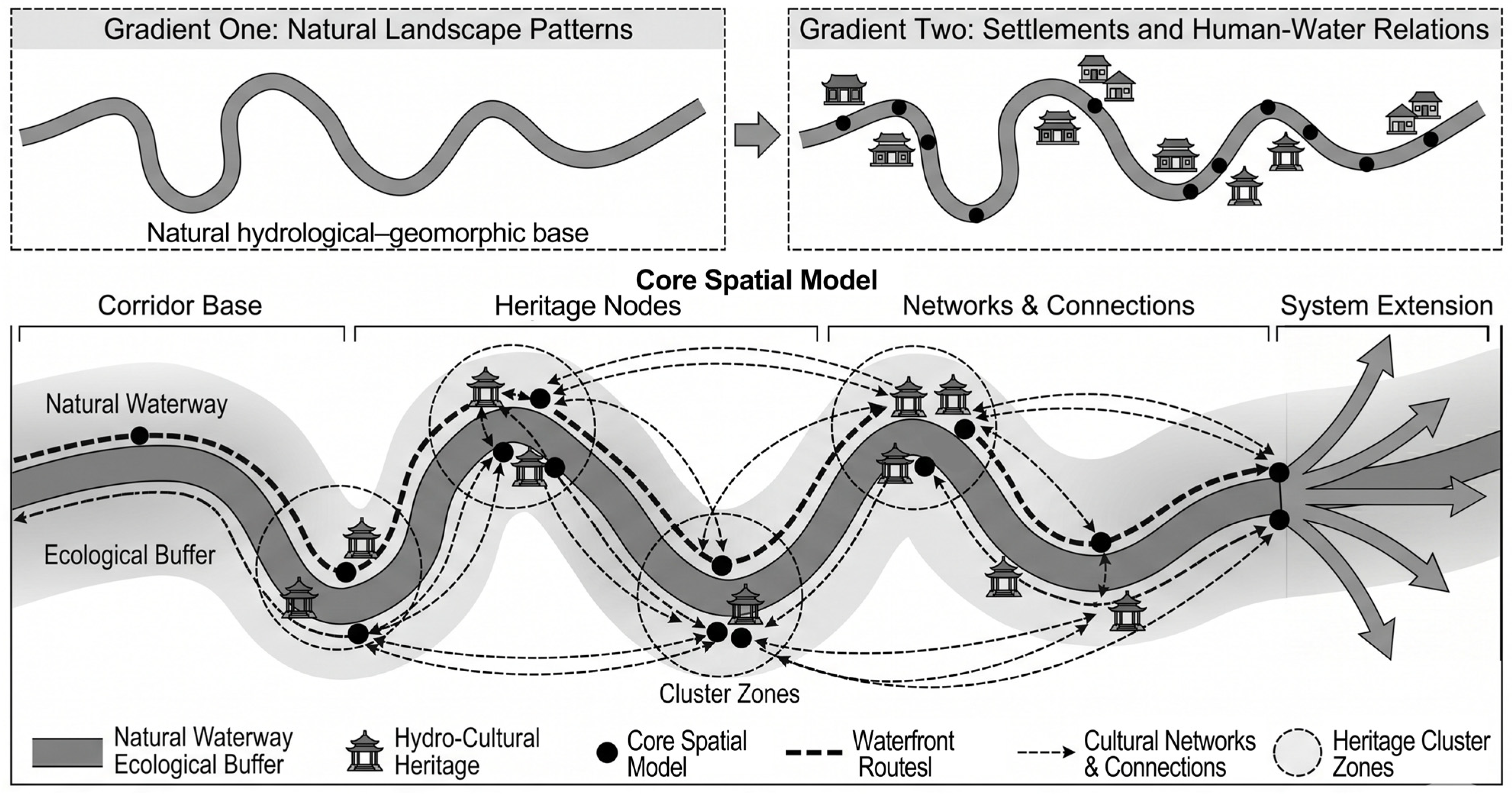
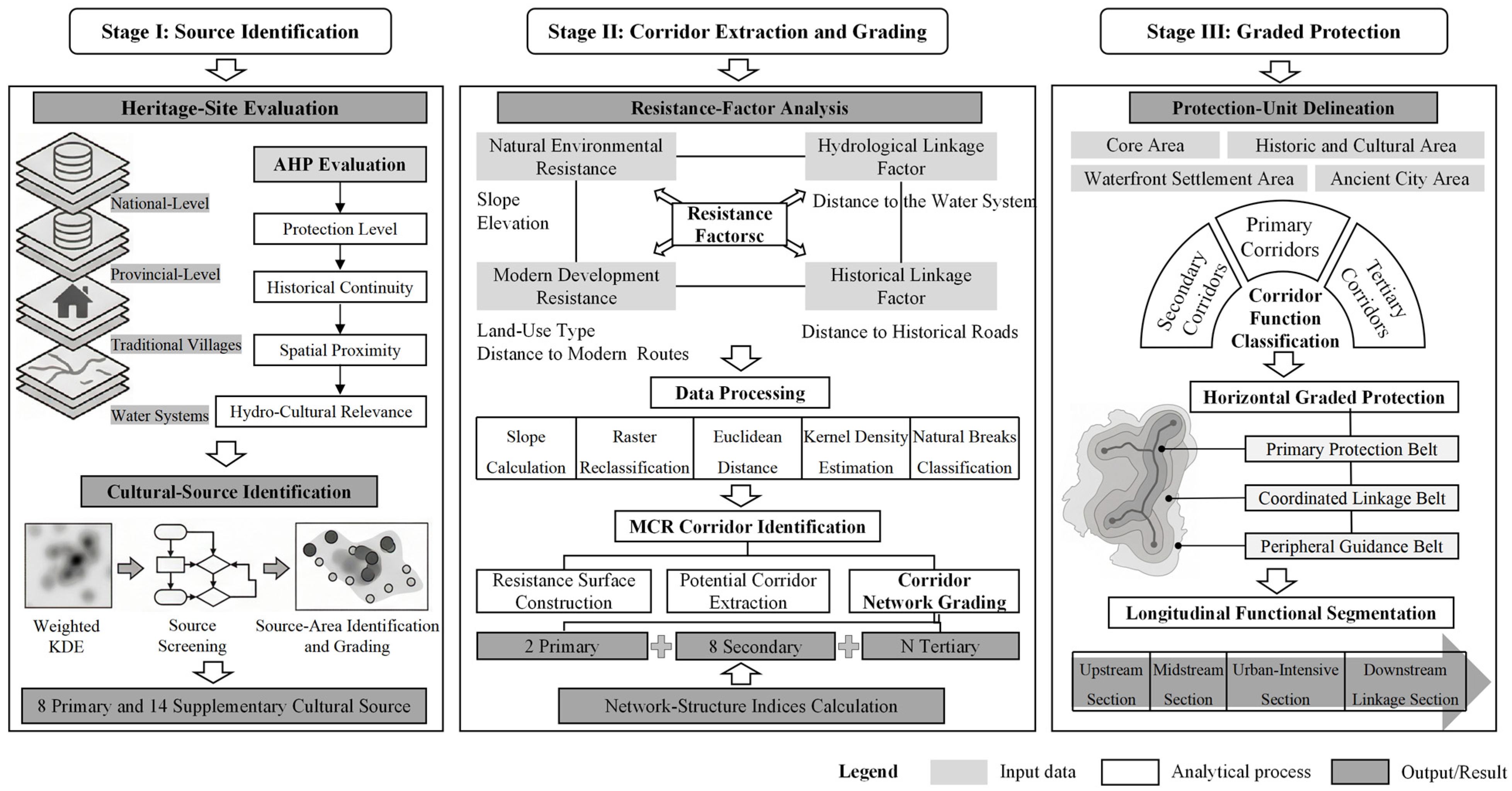
2.4. Research Framework
3. Results
3.1. Evaluation of Hydro-Cultural Heritage and Cultural Source Identification
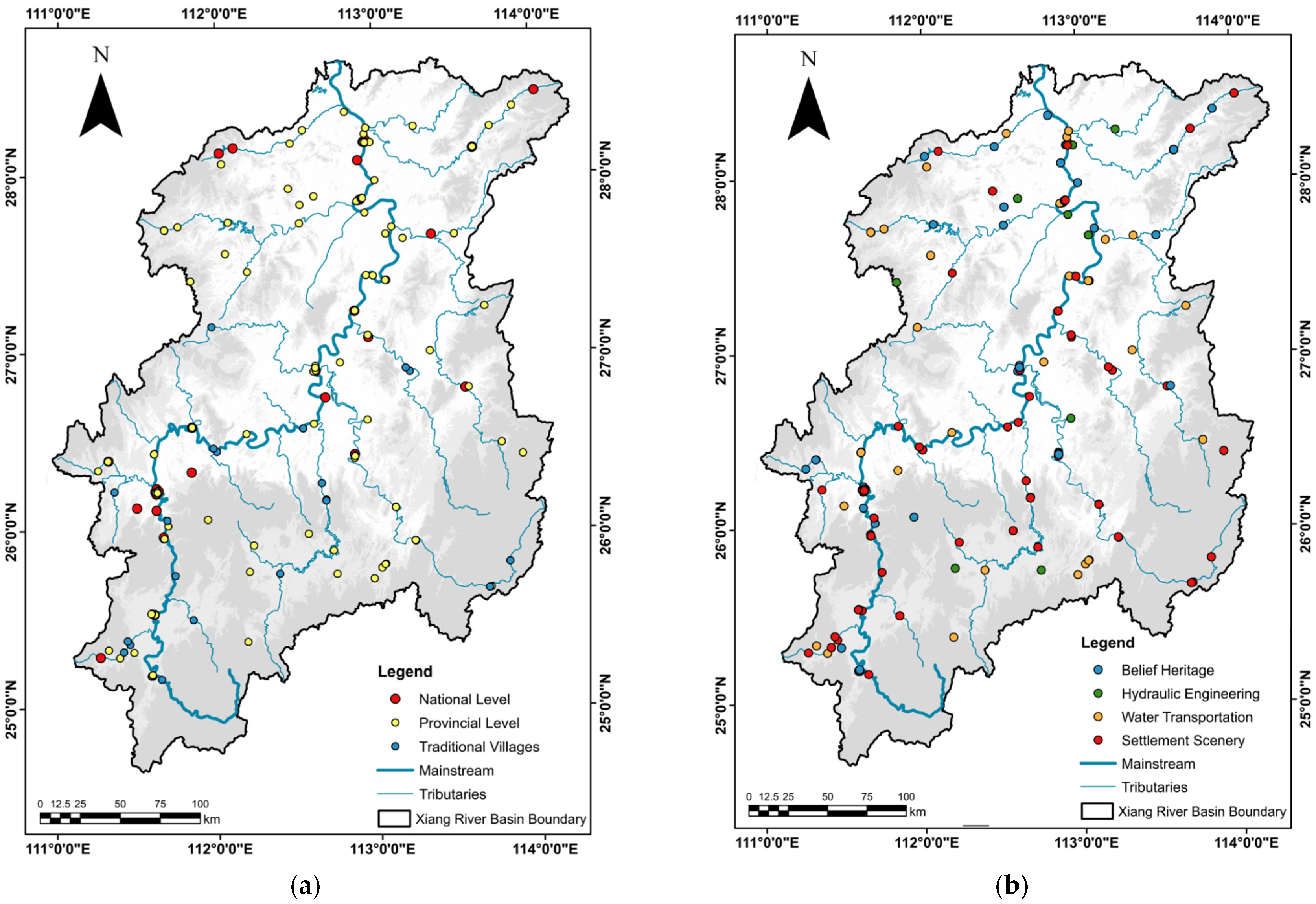
3.1.1. Classification of Hydro-Cultural Heritage Types
3.1.2. Construction of the Hydro-Cultural Heritage Evaluation System
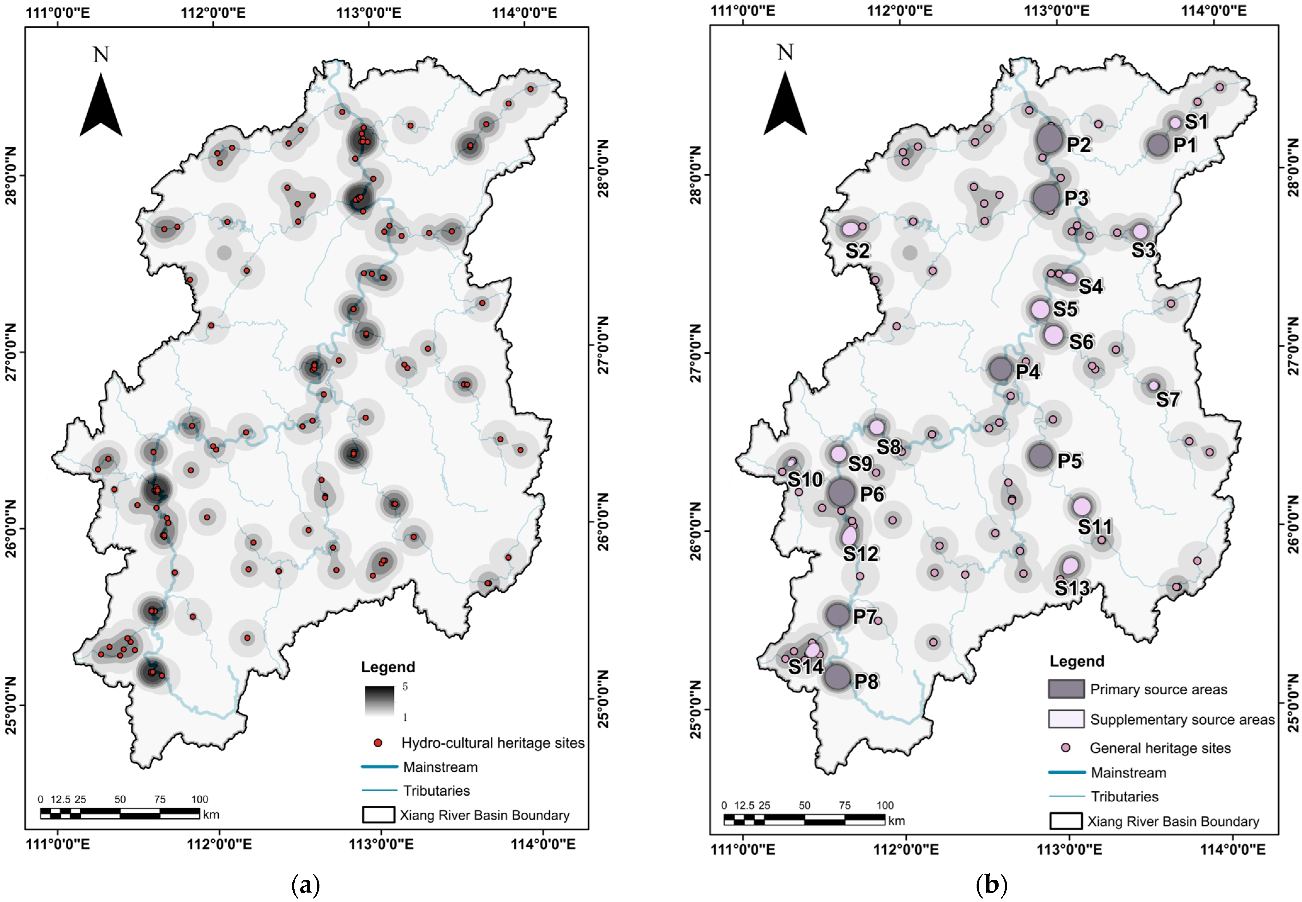
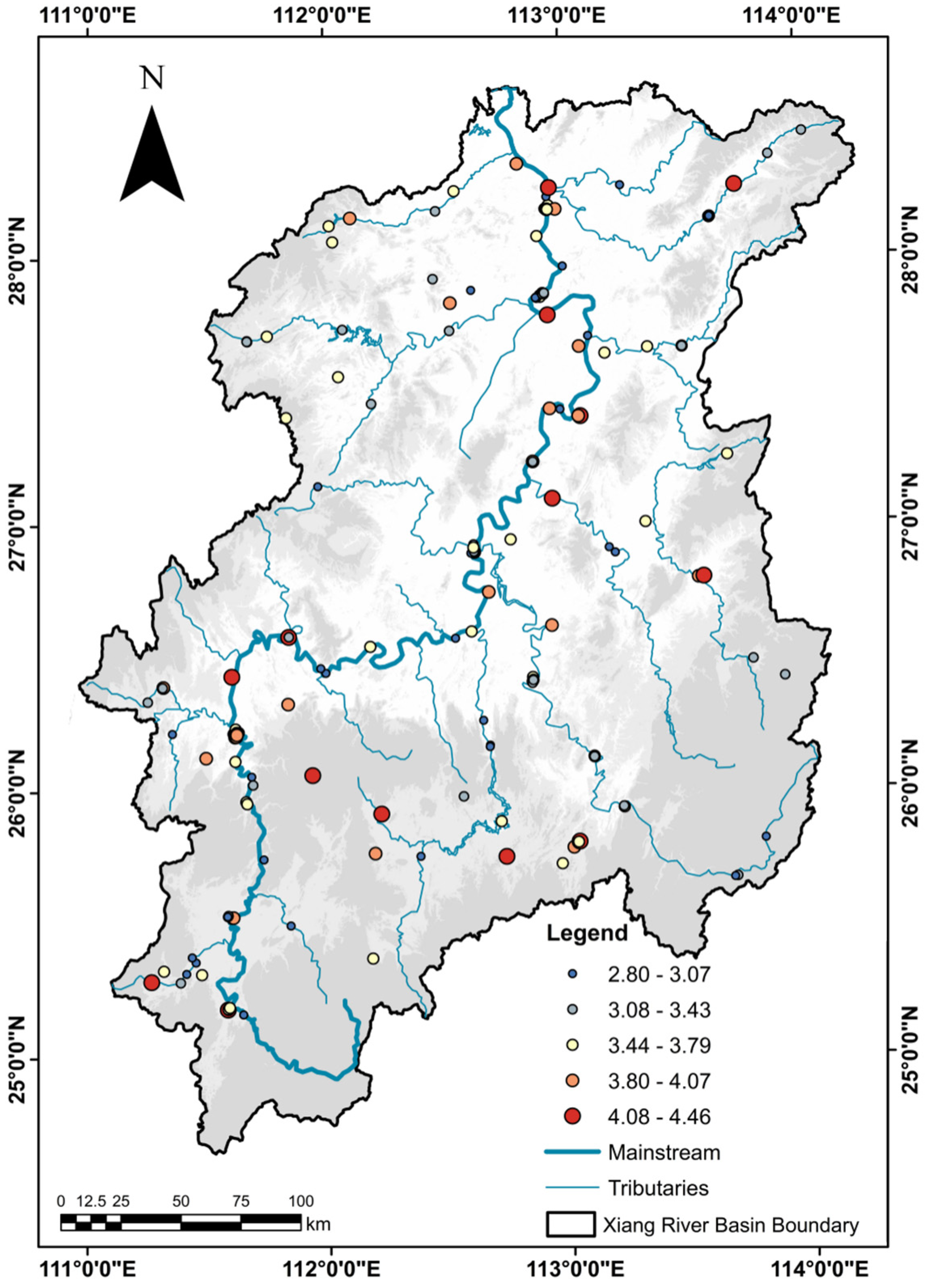
3.1.3. Spatial Clustering Characteristics and Cultural Source Identification
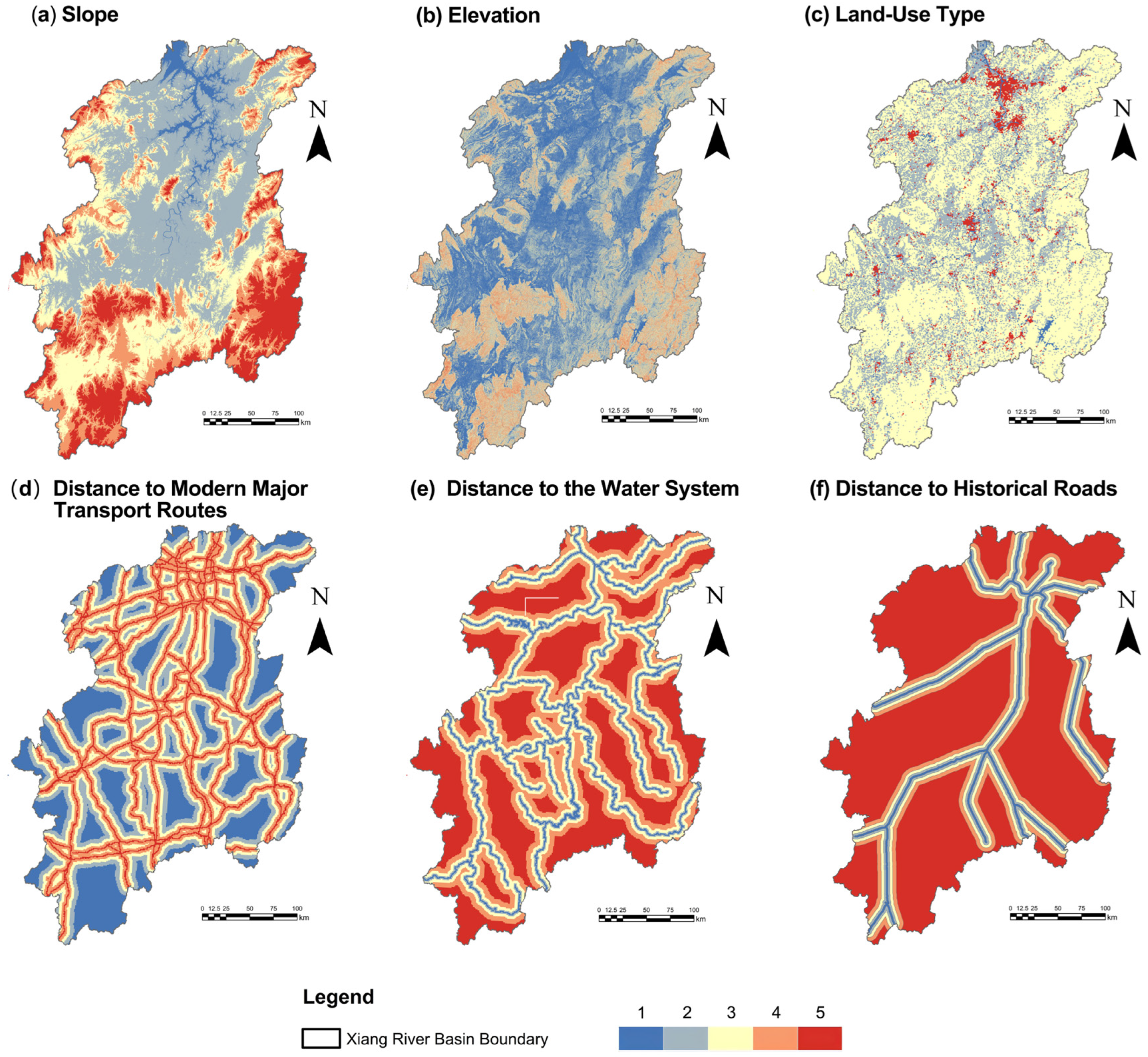
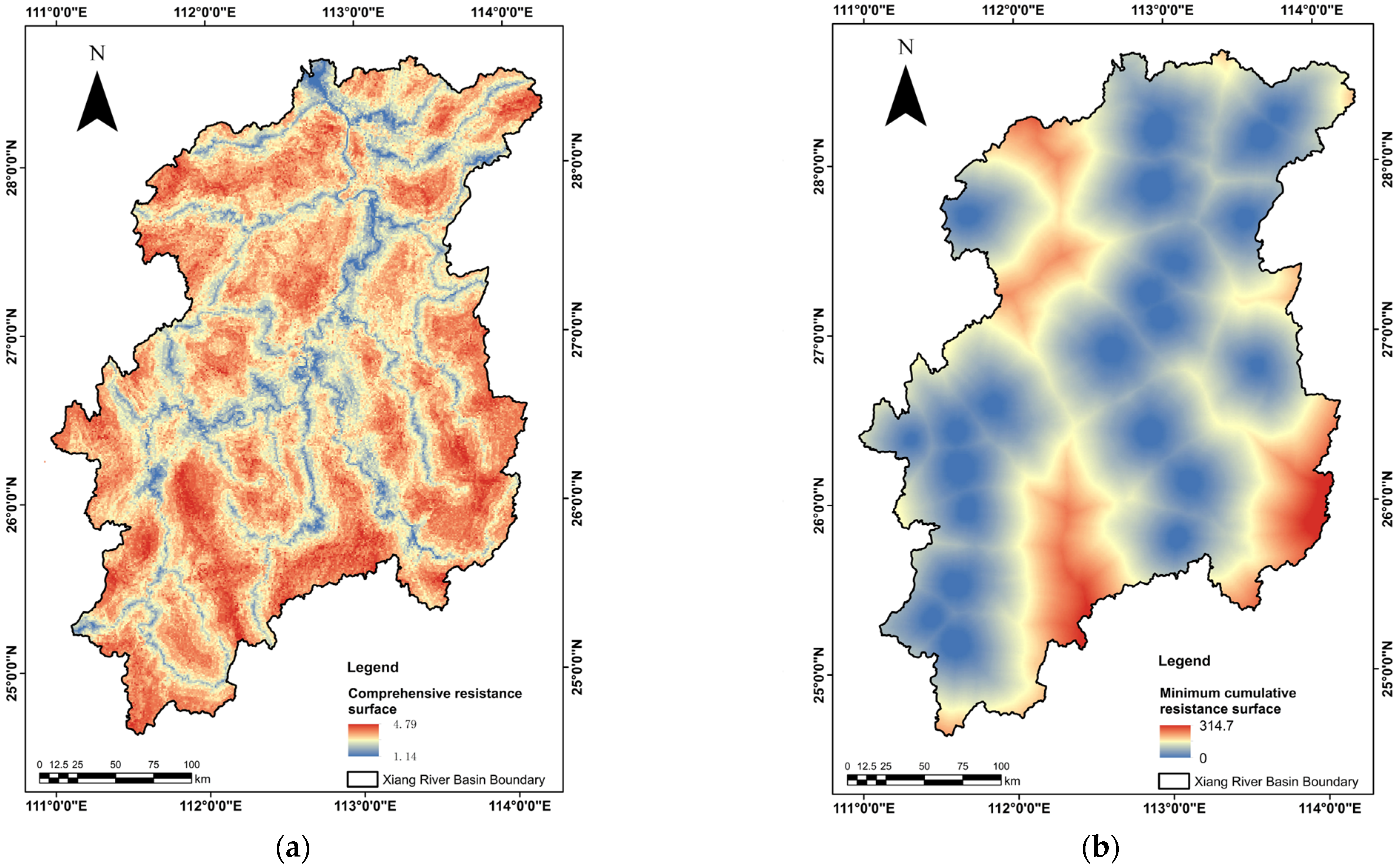
3.2. Construction of the Comprehensive Resistance Surface
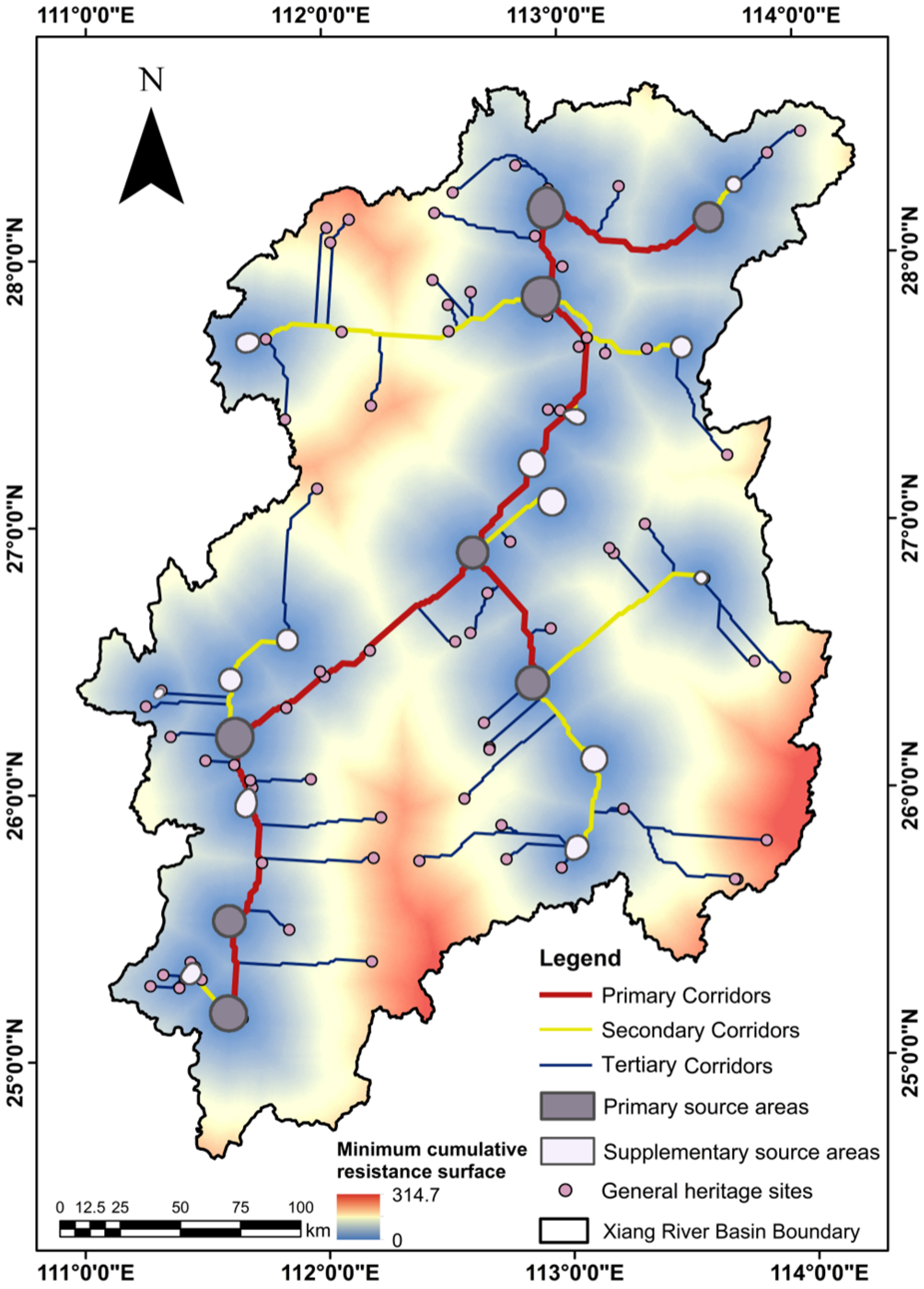
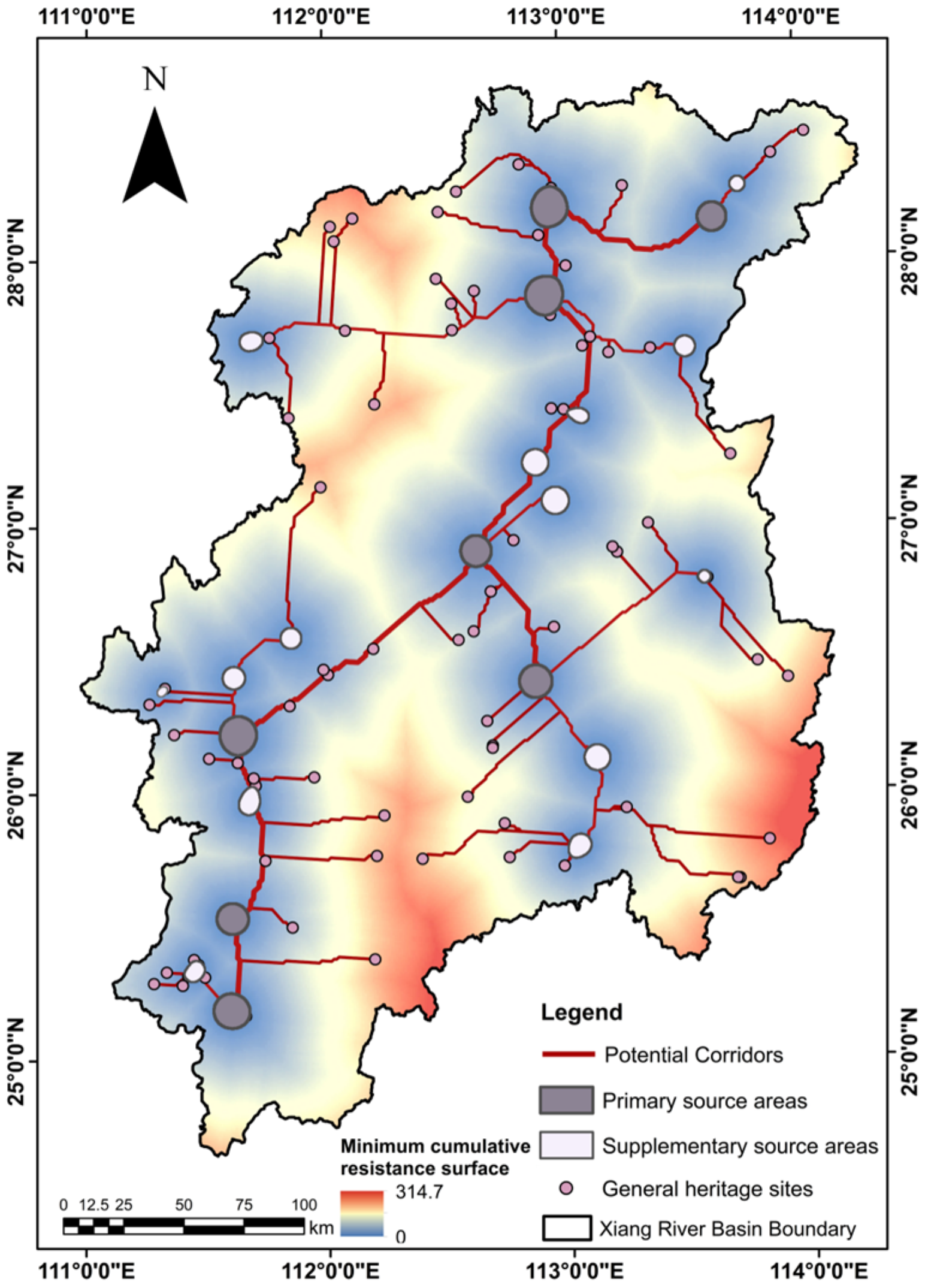
3.3. Extraction of Potential Corridors Based on the MCR Model
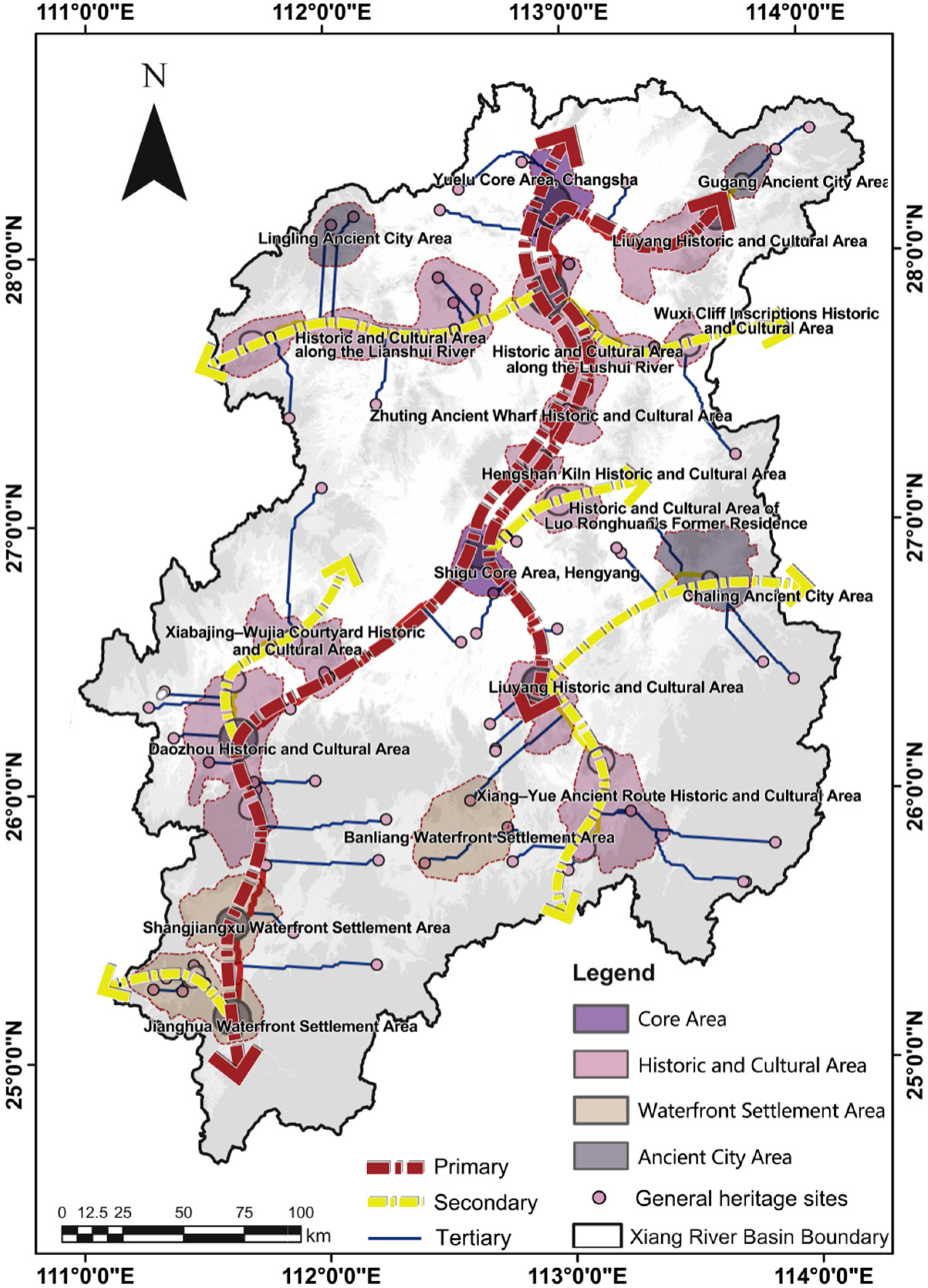
3.4. Grading of Corridor Network Structure
4. Discussion
4.1. Formation Mechanisms of Corridor Patterns and the Significance of Integrated Conservation
4.2. Functional Interpretation and Protection-Oriented Translation of the Graded Corridor Network
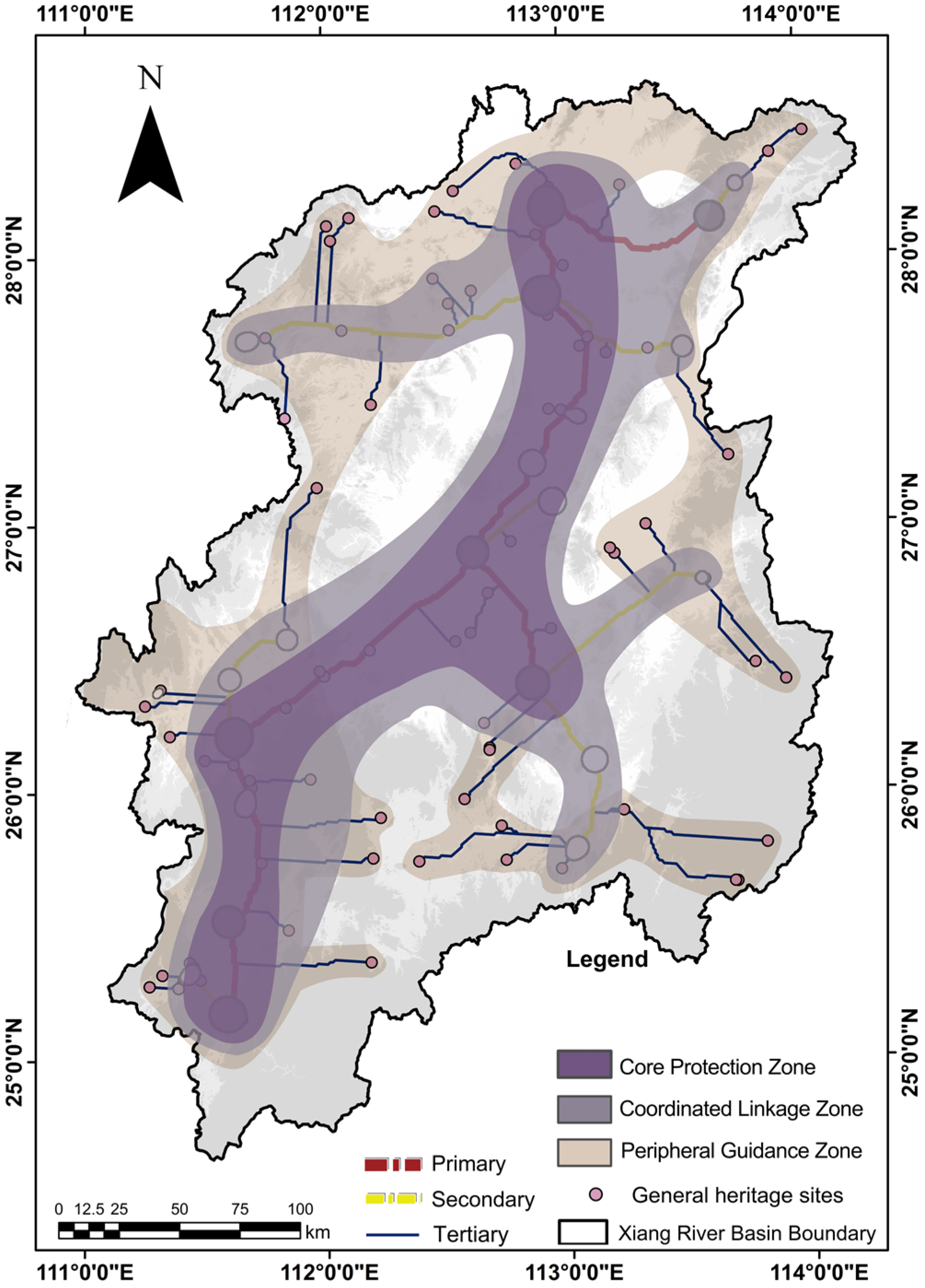
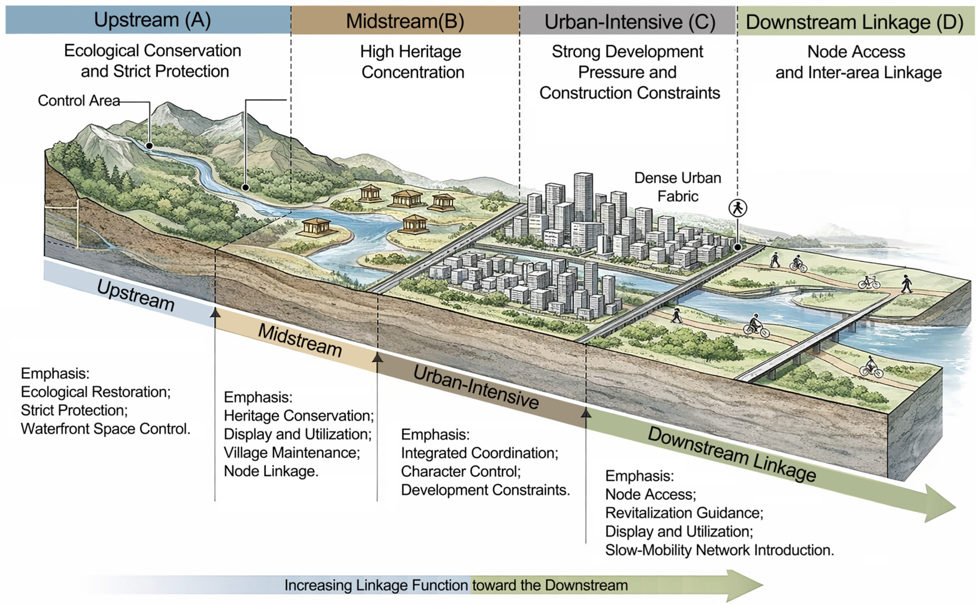
4.3. Planning-Oriented Graded Protection Units and Guidance for Revitalization and Utilization
4.4. Method Applicability, Limitations, and Transferability
5. Conclusions
Supplementary Materials
Author Contributions
Funding
Data Availability Statement
Acknowledgments
Conflicts of Interest
References
- Li, Y.; Wang, C.; Xue, F.; Zhou, K.; Wang, C.-C. Suitability analysis of water cultural heritage structures in Beijing based on analytic hierarchy process and geographic information systems. Buildings 2023, 13, 624. [Google Scholar] [CrossRef]
- Dai, Q.; Wei, Y.; Hu, Y.; Chen, T.; Yan, Y.; Gu, Y.; Wang, Q. Research on the value of water-related cultural heritage architecture from historical environmental records: Evidence from the Li River Basin in China. Land 2024, 13, 838. [Google Scholar] [CrossRef]
- Li, Y.; Shi, Z.; Zhou, K.; Wang, P.; Wang, C.-C. Spatiotemporal distribution of water heritages in the Xishan–Yongding River Cultural Belt. Buildings 2025, 15, 4069. [Google Scholar] [CrossRef]
- Zhao, M.; Xu, Q.; Lan, H.; Wan, J.; Perry, D.M.; Li, P. The spatiotemporal distribution and influencing mechanism of China’s hydraulic heritage sites. Habitat Int. 2025, 166, 103604. [Google Scholar] [CrossRef]
- Jiang, X.; Xu, J. Development process and distribution characteristics of water cultural heritage in Hunan Province. Chin. Overseas Archit. 2023, 7, 14–20. (In Chinese) [Google Scholar]
- Shen, W.; Chen, Y.; Cao, W.; Yu, R.; Rong, P.; Cheng, J. Spatial pattern and its influencing factors of national-level cultural heritage in China. Herit. Sci. 2024, 12, 384. [Google Scholar] [CrossRef]
- Ge, Y.; Liu, Y.; Ma, Y.; Wang, Y.; Guo, Y.; He, J.; Mao, Y. Spatial identification and corridor network analysis of cultural heritage based on multi-model fusion: A case study of western Henan. Ecol. Indic. 2025, 178, 113859. [Google Scholar] [CrossRef]
- Zhang, Z.; Cui, Z.; Fan, T.; Ruan, S.; Wu, J. Spatial distribution of intangible cultural heritage resources in China and its influencing factors. Sci. Rep. 2024, 14, 4960. [Google Scholar] [CrossRef]
- Lin, X.; Shen, Z.; Teng, X.; Mao, Q. Cultural routes as cultural tourism products for heritage conservation and regional development: A systematic review. Heritage 2024, 7, 2399–2425. [Google Scholar] [CrossRef]
- Wang, Z.; Sun, P. Heritage corridors: A relatively new approach to heritage conservation. Chin. Landsc. Archit. 2001, 5, 85–88. (In Chinese) [Google Scholar]
- Sun, Y.; Wang, Y.; Liu, L.; Wei, Z.; Li, J.; Cheng, X. Large-scale cultural heritage conservation and utilization based on cultural ecology corridors: A case study of the Dongjiang–Hanjiang River Basin in Guangdong, China. Herit. Sci. 2024, 12, 44. [Google Scholar] [CrossRef]
- Ma, X. Research on the Protection and Utilization of Water Cultural Heritage in the Middle Reaches of the Dawen River from the Perspective of Heritage Corridors. Master’s Thesis, Shandong Agricultural University, Tai’an, China, 2024. (In Chinese) [Google Scholar]
- Jiang, L.; Cai, J.; Fan, Y. Spatiotemporal distribution and heritage corridor construction of vernacular architectural heritage in the Cao’e River, Jiaojiang River, and Oujiang River Basin. Land 2025, 14, 1484. [Google Scholar] [CrossRef]
- Zhang, S.; Zhang, X.; Liu, J. Spatial distribution and pedigree age of intangible cultural heritage along the Grand Canal of China. Herit. Sci. 2024, 12, 246. [Google Scholar] [CrossRef]
- National Park Service. National Heritage Areas. Available online: https://www.nps.gov/heritageareas/ (accessed on 11 May 2026).
- International Council on Monuments and Sites (ICOMOS). The ICOMOS Charter on Cultural Routes. Int. J. Cult. Prop. 2008, 15, 385–392. [Google Scholar] [CrossRef]
- Li, X.; Zhu, R.; Shi, C.; Yang, X.; Chen, J.; Wei, K. Research on the construction of intangible cultural heritage corridors in the Yellow River Basin based on geographic information system technology and the minimum cumulative resistance model. Herit. Sci. 2024, 12, 271. [Google Scholar] [CrossRef]
- Deng, Y.; Ma, Q.; Zhang, Y. Identification, evaluation, classification of the Chengdu–Chongqing Ancient Road cultural heritage corridor. npj Herit. Sci. 2025, 13, 621. [Google Scholar] [CrossRef]
- Wu, Y.; Zhu, H.; Li, J.; Wu, X. Identification and grading evaluation of the spatial pattern of intangible cultural heritage tourism corridors in the Yangtze River National Cultural Park. Geogr. Res. 2025, 44, 2429–2449. (In Chinese). Available online: https://www.dlyj.ac.cn/EN/10.11821/dlyj020250354 (accessed on 11 May 2026).
- Wang, Q.; Yang, C.; Wang, J.; Tan, L. Tourism in historic urban areas: Construction of cultural heritage corridor based on minimum cumulative resistance and gravity model—A case study of Tianjin, China. Buildings 2024, 14, 2144. [Google Scholar] [CrossRef]
- Li, M.R.; Cao, Y.; Li, G.W. An approach to developing and protecting linear heritage tourism: The construction of cultural heritage corridor of traditional villages in Mentougou District using GIS. Int. J. Geoherit. Parks 2023, 11, 607–623. [Google Scholar] [CrossRef]
- Wang, X.; Zhang, T.; Duan, L.; Liritzis, I.; Li, J. Spatial distribution characteristics and influencing factors of intangible cultural heritage in the Yellow River Basin. J. Cult. Herit. 2024, 66, 254–264. [Google Scholar] [CrossRef]
- Nie, X.; Xie, Y.; Xie, X.; Zheng, L. The characteristics and influencing factors of the spatial distribution of intangible cultural heritage in the Yellow River Basin of China. Herit. Sci. 2022, 10, 121. [Google Scholar] [CrossRef]
- Huang, Y.; Shen, S.; Hu, W.; Li, Y.; Li, G. Construction of cultural heritage tourism corridor for the dissemination of historical culture: A case study of typical mountainous multi-ethnic area in China. Land 2023, 12, 138. [Google Scholar] [CrossRef]
- Zhou, J.; He, J.; Tan, L.; Yan, S. Integrity protection of the Chang Zhen Great Wall heritage corridor based on minimum cumulative resistance. npj Herit. Sci. 2025, 13, 479. [Google Scholar] [CrossRef]
- Xie, Z.; Fang, J.; Wang, L.; Wang, G.; Wang, S. Construction of architectural heritage corridors in the Hubei section of the Tea Road. npj Herit. Sci. 2025, 13, 324. [Google Scholar] [CrossRef]
- Tang, C.; Qiu, T.; Li, Y. Heritage perspectives on cultural memory and spatial identity in Yuan River Basin, Hunan, China. npj Herit. Sci. 2025, 13, 261. [Google Scholar] [CrossRef]
- Yu, Y.; Yu, B.; Zhang, X.; Ma, L.; Zhao, C.; Jia, Y.; Hou, S.; Han, X.; Li, K.; Chen, X.; et al. Construction of symbiosis corridors for heritage resources and optimization of conservation strategies in the basin: A case study of the Yellow River Basin in Shandong, China. Ecol. Indic. 2025, 178, 113962. [Google Scholar] [CrossRef]
- Yang, T. Reflections on the construction of a national cultural heritage spatial system from the perspective of territorial spatial planning. Urban Plan. Forum 2020, 3, 81–87. (In Chinese) [Google Scholar]
- Mao, J. Cultural Studies of the Xiangjiang River Basin; Social Sciences Academic Press: Beijing, China, 2022. (In Chinese) [Google Scholar]
- Hunan Provincial Local Gazetteers Compilation Committee (Ed.) Dianjiao Guangxu Hunan Tongzhi; Collated Edition of the Guangxu Hunan General Gazetteer; Hunan People’s Publishing House: Changsha, China, 2017. (In Chinese) [Google Scholar]
- Li, D. Shui Jing Zhu Jiaozheng; Collated and Verified Commentary on the Water Classic; Chen, Q., Collated and Verified; Zhonghua Book Company: Beijing, China, 2007. (In Chinese) [Google Scholar]
- Zhang, W. Xiangjiang. In The Xiangjiang River; Jiangsu Education Publishing House: Nanjing, China, 2010. (In Chinese) [Google Scholar]
- Sima, Q. Shiji. In Records of the Grand Historian; Zhonghua Book Company: Beijing, China, 2013. (In Chinese) [Google Scholar]
- Jiang, X. Bilu Lanlü yi Qi Shanlin: Hunan Gudai Jiaotong Shi: Shiqian zhi Qingmo. In A History of Ancient Transportation in Hunan: From Prehistory to the End of the Qing Dynasty; China Communications Press: Beijing, China, 2020. (In Chinese) [Google Scholar]
- Hunan Provincial Cultural Relics Bureau (Ed.) Hunan Wenhua Yichan Tudian. In Illustrated Compendium of Hunan Cultural Heritage; Yuelu Press: Changsha, China, 2008. (In Chinese)
- Hunan Provincial Department of Water Resources; Hunan Provincial Department of Culture and Tourism. Hunan Province Water Culture Construction Plan (2021–2035); Hunan Provincial Department of Water Resources: Changsha, China; Hunan Provincial Department of Culture and Tourism: Changsha, China, 2022. (In Chinese) [Google Scholar]
- Willems, W.J.H.; van Schaik, H.P.J. (Eds.) Water and Heritage: Material, Conceptual and Spiritual Connections; Sidestone Press: Leiden, The Netherlands, 2015. [Google Scholar]
- Li, J. Study on Transportation and Changes in Folk Culture in the Xiangjiang River Basin during the Tang and Song Dynasties. Master’s Thesis, Jinan University, Guangzhou, China, 2010. (In Chinese) [Google Scholar]
- Meng, L.; Zhang, B.; Cao, L. Establishing linear cultural heritage corridors by integrating cultural and ecological values: A case study of the Jinzhong section of the Great Tea Road. Land 2026, 15, 293. [Google Scholar] [CrossRef]
- Wu, Y.; Yang, Y.; Miao, M.; Wu, Y.; Zhu, H. Study on spatial distribution and heritage corridor network of traditional settlements in ancient Huizhou. Buildings 2025, 15, 1641. [Google Scholar] [CrossRef]
- Tao, L.; Wang, H.; Li, J.; Zhang, L. Construction of CCSPM model for spatial definition of cultural corridor: A case study of cross-border cultural corridor in southwest Yunnan. Sci. Geogr. Sin. 2022, 42, 602–610. (In Chinese) [Google Scholar] [CrossRef]
- Adriaensen, F.; Chardon, J.P.; De Blust, G.; Swinnen, E.; Villalba, S.; Gulinck, H.; Matthysen, E. The application of least-cost modelling as a functional landscape model. Landsc. Urban Plan. 2003, 64, 233–247. [Google Scholar] [CrossRef]
- Liu, Y.; Ma, X. Heritage corridor construction in the Sui–Tang Grand Canal’s Henan Section based on the minimum cumulative resistance (MCR) model. Land 2025, 14, 2128. [Google Scholar] [CrossRef]
- Meng, L.; Du, Z.; Jia, Z.; Cao, L. Spatial mechanisms and coupling coordination of cultural heritage and tourism along the Jinzhong segment of the Great Tea Road. Heritage 2025, 9, 7. [Google Scholar] [CrossRef]
- Lin, Z.; Li, B. Circuit theory-based cultural heritage corridor network development in Qin River Basin. npj Herit. Sci. 2025, 13, 385. [Google Scholar] [CrossRef]
- Urban, D.L.; Keitt, T.H. Landscape connectivity: A graph-theoretic perspective. Ecology 2001, 82, 1205–1218. [Google Scholar] [CrossRef]
- Li, C.; Qian, Y.; Li, Z.; Tong, T. Identifying factors influencing the spatial distribution of minority cultural heritage in Southwest China. Herit. Sci. 2024, 12, 117. [Google Scholar] [CrossRef]
- Fu, J.; Mao, H. Study on the spatiotemporal distribution patterns and influencing factors of cultural heritage: A case study of Fujian Province. Herit. Sci. 2024, 12, 324. [Google Scholar] [CrossRef]
- Shon, D.; Kim, B.; Lim, E. A GeoDetector–MGWR framework for place-based cultural heritage strategies: Evidence from the Chungcheong Region, South Korea. Land 2026, 15, 384. [Google Scholar] [CrossRef]
- Tress, B.; Tress, G.; Fry, G. Integrative studies on rural landscapes: Policy expectations and research practice. Landsc. Urban Plan. 2005, 70, 177–191. [Google Scholar] [CrossRef]
- Chen, J.; Zhao, X.; Wang, H.; Yan, J.; Yang, D.; Xie, K. Portraying heritage corridor dynamics and cultivating conservation strategies based on environment spatial model: An integration of multi-source data and image semantic segmentation. Herit. Sci. 2024, 12, 419. [Google Scholar] [CrossRef]
- Azzopardi, E.; Kenter, J.O.; Young, J.; Leakey, C.; O’Connor, S.; Martino, S.; Flannery, W.; Sousa, L.P.; Mylona, D.; Frangoudes, K.; et al. What are heritage values? Integrating natural and cultural heritage into environmental valuation. People Nat. 2023, 5, 368–383. [Google Scholar] [CrossRef]
- Li, H.; Jing, J.; Fan, H.; Li, Y.; Liu, Y.; Ren, J. Identifying cultural heritage corridors for preservation through multidimensional network connectivity analysis—A case study of the ancient Tea-Horse Road in Simao, China. Landsc. Res. 2021, 46, 96–115. [Google Scholar] [CrossRef]
- Lin, F.; Zhang, X.; Ma, Z.; Zhang, Y. Spatial structure and corridor construction of intangible cultural heritage: A case study of the Ming Great Wall. Land 2022, 11, 1478. [Google Scholar] [CrossRef]
- Chu, T.; Liu, C.; Li, Z. Composite ecological–heritage–recreation corridors for social sustainability: A regional framework in the Qinling–Daba Mountains. Buildings 2025, 15, 3700. [Google Scholar] [CrossRef]
- Hei, Y.; Sui, Y.; Gao, W.; Zhao, M.; Hu, M.; Gao, M. Geodetector-based analysis of spatiotemporal distribution characteristics and influencing mechanisms for rural homestays in Beijing. Land 2025, 14, 997. [Google Scholar] [CrossRef]
- Du, C.; Pan, D.; Liu, Q. The construction of a protection network for traditional settlements across regions: A case study of the Chengdu–Chongqing Ancient Post Road Heritage Corridor in China. Land 2025, 14, 327. [Google Scholar] [CrossRef]
- Zou, H.; Zhang, G.; Sun, C.; Landrum, L.; Tang, Y.; Hu, Y.; Cheng, W.; Li, A. Thematic cultural heritage tourism trail planning integrating multi-source data and machine learning in Wuhan China. npj Herit. Sci. 2025, 13, 547. [Google Scholar] [CrossRef]
- Wang, Y.-W.; Pendlebury, J.; Nolf, C. The water heritage of China: The polders of Tai Lake Basin as continuing landscape. Plan. Perspect. 2023, 38, 949–974. [Google Scholar] [CrossRef]








| Data Type | Main Source | Specification/Description | Main Use |
|---|---|---|---|
| Hydro-cultural heritage site data | National Cultural Heritage Administration of China, competent cultural heritage authorities of Hunan Province, official catalogues of traditional villages, and other publicly available sources | National-level protected heritage units (through the Eighth Batch, promulgated on 7 October 2019); provincial-level protected heritage units in Hunan (actual list current to 31 December 2024); sixth-batch Chinese Traditional Villages (officially announced on 16 August 2023) | Heritage-site identification, evaluation, weighted kernel density analysis, and cultural source identification |
| Basin boundary data | Relevant geospatial data platforms and previous studies | Basin boundary vector data | Study-area delineation and spatial clipping |
| River-system data | Public geospatial data platforms and related openly available sources | Main stem and tributary vector data | River-system framework extraction, distance-to-water calculation, and spatial relationship analysis |
| DEM data | Geospatial Data Cloud and other public elevation-data platforms | 30 m DEM | Elevation extraction, slope derivation, and construction of the comprehensive resistance surface |
| Land-use data | Public resource and environmental data platforms | Land-use raster data | Land-use classification and construction of the comprehensive resistance surface |
| Modern transport network data | Public transport geospatial data platforms and map data | Road-network vector data current to December 2025 | Distance-to-transport calculation and representation of modern development resistance |
| Historical courier-route data | Historical transport studies, local documentary sources, and manual verification | Historical routes compiled from Qing–Republican sources | Distance-to-route calculation and representation of historical linkage effects |
| Reference/Source | Main Use in Interpretation and Validation |
|---|---|
| Mao Jian, Cultural Studies of the Xiangjiang River Basin; Social Sciences Academic Press: Beijing, China, 2022 [30]. | Used to interpret the historical and cultural evolution, human–water relations, water–land transport, and regional cultural context of the Xiangjiang River Basin. |
| Hunan Provincial Local Gazetteers Compilation Committee, ed., Collated Edition of the Guangxu Hunan General Gazetteer; Hunan People’s Publishing House: Changsha, China, 2017; collated edition [31]. | Used to verify Qing-period geography, river systems, administrative divisions, ferry crossings, roads, and local historical records in Hunan. |
| Li Daoyuan; Chen Qiaoyi, collated and verified, Shui Jing Zhu Jiaozheng (Collated and Verified Commentary on the Water Classic); Zhonghua Book Company: Beijing, China, 2007 [32]. | Used to interpret ancient river systems, hydrological geography, and early historical-geographical background. |
| Zhang Weiran, Xiangjiang (The Xiangjiang River); Jiangsu Education Publishing House: Nanjing, China, 2010 [33]. | Used to interpret the Xiangjiang main stem, river culture, regional cultural cognition, and human–land relations. |
| Sima Qian, Shiji (Records of the Grand Historian); Zhonghua Book Company: Beijing, China, revised edition, 2013; punctuated edition first published in 1959 [34]. | Used to provide early historical background and macro-historical context for long-term human–environment interactions. |
| Jiang Xiangyuan, Bilu Lanlü yi Qi Shanlin: A History of Ancient Transportation in Hunan from Prehistory to the End of the Qing Dynasty; China Communications Press: Beijing, China, 2020 [35]. | Used to interpret ancient transport, waterways, postal roads, and water–land transport linkages in Hunan. |
| Hunan Provincial Cultural Relics Bureau, ed., Illustrated Compendium of Hunan Cultural Heritage; Yuelu Press: Changsha, China, 2008 [36]. | Used to verify heritage-site names, types, images, and basic information for sample verification. |
| Hunan Provincial Department of Water Resources and Hunan Provincial Department of Culture and Tourism, Hunan Province Water Culture Construction Plan (2021–2035); Changsha, China, 2022 [37]. | Used as a contemporary policy reference for water-culture construction, heritage protection, resource investigation, and heritage utilisation. |
| Jiang Xi and Xu Jianhe, “Development Process and Distribution Characteristics of Water Cultural Heritage in Hunan Province”; Chinese and Overseas Architecture, 2023, Issue 7, pp. 14–20 [38]. | Used to interpret the classification, development stages, and spatial distribution characteristics of water cultural heritage in Hunan Province. |
| Li Juan, Study on Transportation and Changes in Folk Culture in the Xiangjiang River Basin during the Tang and Song Dynasties; Master’s thesis, Jinan University: Guangzhou, China, 2010 [39]. | Used to supplement the historical evolution of transportation and waterborne cultural linkages in the Xiangjiang River Basin during the Tang and Song dynasties. |
| Type | Description | Typical Examples | Number of Sites | Share (%) |
|---|---|---|---|---|
| Water Conservancy Heritage | Engineering facilities and related remains reflecting historical water-use practices such as flood control, water diversion, irrigation, flood prevention, and water supply | Aqueducts, irrigation districts, flood-control embankments, ancient wells, springs | 10 | 5.52 |
| Water-Transport Heritage | Connectivity facilities formed on the basis of river systems and regional routes, including bridges, ferry crossings, wharves, ancient roads, guild halls, and transport nodes | Ancient bridges, ancient ferry crossings, wharves, docks, guild halls, ancient roads | 34 | 18.78 |
| Settlement-Landscape Heritage | Heritage types reflecting the construction of waterfront settlements, the development of traditional villages, the spatial organization of production and everyday life, and related historical landscapes | Traditional villages, historic building complexes, ancient city walls, kiln sites, academies, former residences | 100 | 55.25 |
| Belief and Ritual Heritage | Remains associated with water-related memory, water-deity beliefs, local spiritual expression, and commemorative functions | Temples, ancestral halls, stelae, stone inscriptions, pagodas, memorial monuments | 37 | 20.44 |
| Total | — | — | 181 | 100.00 |
| Criterion Dimension | Indicator | Indicator Meaning | Description |
|---|---|---|---|
| Representativeness | Protection Level (A1) | Officially recognized significance | Reflects the importance of a heritage site within the existing heritage-protection system. |
| Continuity | Historical Continuity (A2) | Depth of historical continuity | Reflects the time depth of heritage formation and the degree of historical accumulation. |
| Clustering | Spatial Proximity (A3) | Degree of surrounding heritage concentration | Reflects the potential of a heritage site to form a spatial clustering core. |
| Relevance | Hydro-cultural Relevance (A4) | Strength of hydro-cultural association | Reflects the degree of direct association of a heritage site with water transport, water engineering, waterfront settlements, and hydro-cultural activities. |
| Indicator | Weight |
|---|---|
| Protection Level (A1) | 0.34 |
| Historical Continuity (A2) | 0.18 |
| Spatial Proximity (A3) | 0.09 |
| Hydro-cultural Relevance (A4) | 0.39 |
| Factor | Representative References | Adopted in This Study | Explanation |
|---|---|---|---|
| Elevation | [44,45,54,55] | Yes | Represents the basic constraint imposed by the broader topographic setting on spatial accessibility. |
| Slope | [44,45,54,55] | Yes | Reflects local movement conditions and surface-relief constraints. |
| Distance to the Water System | [3,4,6] | Yes | Captures the dependence of hydro-cultural heritage on the river-system framework and hydrological proximity. |
| Historical Roads | [44,45] | Yes | Represents traditional transport routes and historical accessibility linkages. |
| Land-Use Type | [44,45,54,55] | Yes | Reflects the influence of development intensity and landscape background on corridor formation. |
| Distance to Modern Major Transport Routes | [44,45,55] | Yes | Represents the fragmentation and disturbance imposed by modern infrastructure on traditional spatial continuity. |
| GDP, Population Density, POI, etc. | [3,4,6] | No | Common in studies of macro-scale spatial distribution, but poorly matched to historical processes in terms of temporal scale and not conducive to unified expression at the basin scale. |
| Ancient Wharves, Ancient Ferry Crossings, Jin Kou-Type Nodes, etc. | [5,12,19,44] | No | Theoretically important, but not incorporated into the formal resistance-factor system because the currently available data are limited in quantity, spatially incomplete, and insufficiently representative. |
| Dimension | Resistance Factor | Description | Effect on Resistance | Level 1 | Level 2 | Level 3 | Level 4 | Level 5 |
|---|---|---|---|---|---|---|---|---|
| Natural Environmental Resistance (B) | Slope (°) | Reflects the basic constraint of surface relief on corridor connectivity. | Positive (+) | 0–8 | 8–15 | 15–25 | 25–45 | >45 |
| Natural Environmental Resistance (B) | Elevation (m) | Reflects the basic constraint of topographic conditions on corridor connectivity. | Positive (+) | 0–50 | 50–150 | 150–300 | 300–600 | >600 |
| Modern Development Resistance (C) | Land-Use Type | Reflects the disturbance of different land-development intensities on the continuity of cultural space. | Categorical assignment | Water bodies | Cultivated land | Forest and grassland | Unused land | Urban, industrial, and residential land |
| Modern Development Resistance (C) | Distance to Modern Major Transport Routes (km) | Reflects the fragmenting disturbance of modern transport infrastructure on traditional hydro-cultural space. | Negative (–) | >10 | 6–10 | 3–6 | 1–3 | <1 |
| Hydrological–Historical Linkage Factor (D) | Distance to the Water System (km) | Reflects the proximity of heritage space to the river-system framework and the strength of hydrological linkage. | Positive (+) | 0–0.5 | 0.5–2 | 2–5 | 5–10 | >10 |
| Hydrological–Historical Linkage Factor (D) | Distance to Historical Roads (km) | Reflects the strength of linkage between heritage space and the traditional overland transport network. | Positive (+) | <1 | 1–3 | 3–6 | 6–10 | >10 |
| Dimension | Criterion Weight | Resistance Factor | Local Weight | Overall Weight |
|---|---|---|---|---|
| Natural Environmental Resistance (B) | 0.207 | Slope | 0.545 | 0.113 |
| Natural Environmental Resistance (B) | 0.207 | Elevation | 0.455 | 0.094 |
| Modern Development Resistance (C) | 0.331 | Land-Use Type | 0.583 | 0.193 |
| Modern Development Resistance (C) | 0.331 | Distance to Modern Major Transport Routes | 0.417 | 0.138 |
| Hydrological–Historical Linkage Factor (D) | 0.462 | Distance to the Water System | 0.600 | 0.277 |
| Hydrological–Historical Linkage Factor (D) | 0.462 | Distance to Historical Roads | 0.400 | 0.185 |
| Network Level | Number of Nodes (V) | Number of Links (L) | Alpha Index (α) | Beta Index (β) | Gamma Index (γ) | Structural Characteristic |
|---|---|---|---|---|---|---|
| Primary Network | 8 | 7 | 0.000 | 0.875 | 0.389 | Dendritic backbone with limited loop redundancy |
| Primary–Secondary Network | 21 | 32 | 0.324 | 1.524 | 0.561 | Enhanced local connectivity and alternative linkages |
| Complete Graded Network | 201 | 212 | 0.030 | 1.055 | 0.355 | Expanded peripheral access through dendritic terminal links |
| Representative Graded Corridor | Historical Evidence Used for Validation | Consistency Judgement |
|---|---|---|
| Representative primary corridor along the Xiangjiang main stem and Xiaoshui direction | Consistent with documentary descriptions of the Xiangjiang main stem and the Xiaoshui River as long-term waterborne transport and trade corridors; the modelled direction also connects a series of waterfront settlement areas, ancient-city nodes, wharf-related locations, and historical-cultural cores distributed along this north–south linkage. | High |
| Representative primary corridor linking the Xiangjiang main stem with eastern tributary areas | Consistent with the documented distribution of historical towns, temples, ancient city sites, and water–land transition nodes along the Xiangjiang main stem and its major eastern tributaries, the corridor direction reflects the connection between the main river axis and tributary-based cultural nodes. | High |
| Representative secondary corridor in the Lushui–Zhuzhou section | Shows spatial agreement with documentary records and local evidence of ferry crossings, wharves, waterfront settlements, and regional transport nodes around the Lushui–Zhuzhou section, indicating a historically plausible tributary-to-main-stem linkage. | Moderate–High |
| Representative secondary corridor in the Qishui–middle Xiaoshui area | Shows spatial agreement with historical ferry and wharf nodes, waterfront settlement belts, and regional cultural-linkage directions in the Qishui–middle Xiaoshui area, supporting its interpretation as a secondary corridor for southwestern regional supplementation. | Moderate–High |
| Corridor Grade | Corridor Name | Start–End Section/Core Nodes | Supporting Water System | Main Function |
|---|---|---|---|---|
| Primary Corridor | Xiangjiang–Xiaoshui North–South Through Corridor | Changsha Yuelu Core Area—Xiangtan Yaowan Core Area—Hengyang Shigu Core Area—Lingling Ancient City Core Area—Daozhou Historical-Cultural Area—Jianghua Waterfront Settlement Area | Xiangjiang main stem; Xiaoshui main stem | Connects the core source areas of the basin and constitutes the north–south structural backbone of the entire basin |
| Primary Corridor | Liuyang River–Xiangjiang–Leishui Eastern-Linkage Primary Corridor | Liuyang Historical-Cultural Area—Changsha Yuelu Core Area—Xiangtan Yaowan Core Area—Hengyang Shigu Core Area—Caihou Shrine Historical-Cultural Area | Liuyang River; Xiangjiang main stem; Leishui | Connects high-value source areas in the eastern wing and strengthens the linkage between the principal axis and eastern tributary systems |
| Secondary Corridor | Upper Liuyang River Linkage Secondary Corridor | Gugang Ancient City Area—Liuyang Historical-Cultural Area | Liuyang River | Supplements the connection between upstream Liuyang River nodes and the main network |
| Secondary Corridor | Lianshui Western-Wing Linkage Secondary Corridor | Historical-Cultural Areas along the Lianshui River—Xiangtan Yaowan Core Area | Lianshui | Promotes linkage between western-wing tributary areas and the principal axis |
| Secondary Corridor | Lushui–Xiangjiang Zhuzhou Section Linkage Secondary Corridor | Historical-Cultural Areas along the Lushui River—Zhuting Ancient Wharf Historical-Cultural Area—Xiangtan Yaowan Core Area | Lushui; Xiangjiang main stem | Strengthens the connection between northeastern-wing areas and the main network of the middle–lower Xiangjiang River |
| Secondary Corridor | Middle Xiangjiang–Xietaishui Linkage Secondary Corridor | Hengshan Kiln Historical-Cultural Area—Former Residence of Luo Ronghuan Historical-Cultural Area—Hengyang Shigu Core Area | Xiangjiang main stem; Xietaishui | Supports supplementary linkage and extension between the middle Xiangjiang River and tributary areas |
| Secondary Corridor | Upper Leishui Linkage Secondary Corridor | Chaling Ancient City Historical-Cultural Area—Caihou Shrine Historical-Cultural Area | Upper tributaries of the Leishui River | Promotes the connection of southeastern upstream areas to the main network |
| Secondary Corridor | Southern Leishui Linkage Secondary Corridor | Banliang Waterfront Settlement Area—Xiang—Yue Ancient Route Historical-Cultural Area—Caihou Shrine Historical-Cultural Area | Leishui (Dongjiang and Oushui branches) | Strengthens the continuity between southeastern areas and the Leishui linkage belt |
| Secondary Corridor | Qishui–Luhongjiang–Middle Xiaoshui Linkage Secondary Corridor | Wuxi Cliff-Inscriptions Historical-Cultural Area—Xiabajing—Wu Family Mansion Historical-Cultural Area—Lingling Ancient City Core Area | Qishui; Luhongjiang; Xiaoshui | Improves internal supplementation in the southwestern area and enhances network support in the middle Xiaoshui section |
| Secondary Corridor | Yongming River–Southern Xiaoshui Linkage Secondary Corridor | Shangjiangxu Waterfront Settlement Area—Jianghua Waterfront Settlement Area | Yongming River; Xiaoshui | Maintains the connection between southern marginal areas and the main network |
| Tertiary Corridor | Tertiary Corridors of Node-Connection, Tributary-Extension, and Local-Linkage Types | General heritage sites and peripheral nodes | Nearby tributaries or waterfront paths | Realizes the connection of general heritage sites and the local extension of the network |
| Protection Belt Type | Spatial Basis | Indicative Spatial Guidance | Planning Implication |
|---|---|---|---|
| Primary Protection Belt | Primary corridors + primary cultural source areas + continuous waterfront heritage clusters | Integrate primary corridor axes, primary source-area patches, and a wider cultural–ecological transition zone; calibrate boundaries with existing statutory protection boundaries and territorial planning units. | Maintain basin-scale axial continuity, protect core source areas, and control high-intensity construction in key linkage spaces. |
| Coordinated Linkage Belt | Secondary corridors + supplementary cultural source areas + tributary linkage spaces | Integrate secondary corridor axes, supplementary source areas, tributary transition zones, and medium-intensity linkage zones. | Strengthen regional coordination, tributary linkage, restoration of fragmented sections, and transition between network levels. |
| Peripheral Guidance Belt | Terminal corridors + general heritage sites + peripheral nodes | Integrate terminal linkages, general heritage sites, and low-intervention local guidance spaces. | Support peripheral access, slow-mobility interpretation, local revitalization, and gradual use. |
Disclaimer/Publisher’s Note: The statements, opinions and data contained in all publications are solely those of the individual author(s) and contributor(s) and not of MDPI and/or the editor(s). MDPI and/or the editor(s) disclaim responsibility for any injury to people or property resulting from any ideas, methods, instructions or products referred to in the content. |
© 2026 by the authors. Licensee MDPI, Basel, Switzerland. This article is an open access article distributed under the terms and conditions of the Creative Commons Attribution (CC BY) license.
Share and Cite
Wu, Y.; Jiao, S.; Liu, W.; Yu, Y.; Xiao, K. A Basin-Scale Framework for Identifying Hydro-Cultural Heritage Corridor Patterns and Guiding Graded Protection: Evidence from the Xiangjiang River Basin, China. Land 2026, 15, 914. https://doi.org/10.3390/land15060914
Wu Y, Jiao S, Liu W, Yu Y, Xiao K. A Basin-Scale Framework for Identifying Hydro-Cultural Heritage Corridor Patterns and Guiding Graded Protection: Evidence from the Xiangjiang River Basin, China. Land. 2026; 15(6):914. https://doi.org/10.3390/land15060914
Chicago/Turabian StyleWu, Yifan, Sheng Jiao, Wenting Liu, Yan Yu, and Kaiyin Xiao. 2026. "A Basin-Scale Framework for Identifying Hydro-Cultural Heritage Corridor Patterns and Guiding Graded Protection: Evidence from the Xiangjiang River Basin, China" Land 15, no. 6: 914. https://doi.org/10.3390/land15060914
APA StyleWu, Y., Jiao, S., Liu, W., Yu, Y., & Xiao, K. (2026). A Basin-Scale Framework for Identifying Hydro-Cultural Heritage Corridor Patterns and Guiding Graded Protection: Evidence from the Xiangjiang River Basin, China. Land, 15(6), 914. https://doi.org/10.3390/land15060914