Article

Spatial Reconfiguration of the Metropolitan Fringe Areas Under Policy Evolution—Taking Guangming District of Shenzhen as an Example

School of Geography and Planning, Sun Yat-Sen University, Guangzhou 510006, China
*
Authors to whom correspondence should be addressed.
Land 2026, 15(5), 717; https://doi.org/10.3390/land15050717
Submission received: 19 February 2026 / Revised: 11 April 2026 / Accepted: 22 April 2026 / Published: 24 April 2026

Abstract

With the accelerating processes of globalization and urbanization, metropolitan fringe areas—situated at the intersection of urban expansion and rural transformation—have become critical focal points in urban geography, regional economics, and urban–rural planning. Within the context of China’s new urbanization strategy and the national “dual circulation” framework, the role of policy evolution in shaping spatial development has become increasingly significant. Specifically, in metropolitan fringe zones such as Shenzhen’s Guangming District, the complex interplay between overlapping policies and local path dependencies has generated a distinctive logic of spatial restructuring. Taking this area as a case study, this research investigates the influence of national policies on regional evolution and spatial reconstruction. The findings demonstrate that, under sustained policy guidance, Guangming District has experienced a three-stage process of spatial restructuring, characterized by a dynamic and tightly coupled relationship between policy instruments and spatial forms across different developmental phases.

1. Introduction

Globalization, as one of the most defining economic and social phenomena of the twenty-first century, has profoundly reshaped the logics and pathways of regional development. Amid accelerating flows of capital, technology, and talent, regions are no longer passive “containers” that merely absorb the impacts of globalization. Rather, they have emerged as active agents that strategically embed themselves within global production networks, participating in processes of value creation and spatial restructuring. However, such participation is far from a linear or one-directional process; it exhibits multiple layers of complexity. Interactions among local policies, institutional innovations, and diverse actors further intensify the uncertainties of regional development. This complexity is particularly pronounced in metropolitan peripheries, which simultaneously serve as frontiers of global expansion and contested arenas where local resources intersect and negotiate with global capital.
Building upon this context, the ongoing wave of scientific and technological revolution and industrial transformation is propelling global production networks into a phase of knowledge-based restructuring. The traditional core–periphery division of labor has been fundamentally reconfigured: peripheral regions are no longer mere recipients of low-end manufacturing or factor supply. Through strategic infrastructure investment and policy innovation, they are increasingly repositioned as critical nodes in global innovation networks [1,2]. This restructuring process bears particular significance for metropolitan peripheries in developing countries. On one hand, these areas carry the strategic mission of absorbing core urban functions and facilitating industrial upgrading; on the other hand, path dependencies established under factor-driven development (such as low-value manufacturing lock-in and spatial fragmentation) intersect with emerging global uncertainties (e.g., geopolitical tensions and technological decoupling), posing a dual challenge for transformation [3,4,5,6].
The ongoing wave of technological revolution and industrial transformation is driving global production networks into a phase of “knowledge-based” restructuring. Instead, through strategic infrastructure investment and policy innovation, they are increasingly repositioned as critical nodes within global innovation networks [1,2]. This restructuring process bears particular significance for metropolitan peripheries in developing countries. On the one hand, these areas carry the strategic mandate of absorbing core urban functions and facilitating industrial upgrading; on the other hand, deeply embedded path dependencies inherited from factor-driven development—such as lock-in to low-value-added production and spatial fragmentation—intersect with emerging global uncertainties, including geopolitical tensions and technological decoupling, thereby imposing dual constraints on regional transformation [4,6,7,8,9].
As highly dynamic yet structurally contradictory spaces within the intertwined processes of globalization and urbanization, metropolitan peripheries have become critical areas for urban expansion, industrial restructuring, and socio-spatial reconfiguration. Their distinctiveness lies not only in their transitional geographic position, but also in the complex interweaving of policy, economic, and social processes that shape their evolution. In China, a major global manufacturing country, the transformation of metropolitan peripheries has emerged as a key developmental issue. Within the rapidly urbanizing Guangdong–Hong Kong–Macao Greater Bay Area, Guangming District in Shenzhen exemplifies this transformation. As the city’s northern sub-centre, Guangming plays a pivotal role in accommodating spatial expansion and functional decentralization by absorbing industrial relocation and population spillover from the urban core. Yet, owing to its in-between status—“neither fully urban nor rural”—Guangming faces acute spatial tensions, including land-use conflicts, ecological compression, and frictions between innovation-led development and spatial constraints. These challenges underscore the urgency of exploring new models of high-quality spatial organization and governance. In particular, how does policy evolution change the position of Guangming District, Shenzhen in the global network through non-inter-firm games, ultimately driving spatial restructuring and achieving path breakthroughs? What is the dynamic mechanism behind this? Evolving from a state-owned agricultural farm to the “Guangming Factory” and now toward a national-level science city, Guangming District encapsulates the co-evolution of policy regimes and spatial restructuring under China’s broader trajectory of state-led urban transformation.

1.1. Concept of Metropolitan Fringe Areas and Its Evolution

The conceptual evolution of metropolitan peripheries is rooted in the dynamic transformation of urban–rural relations, with its theoretical origins traceable to the late nineteenth century’s early explorations of spatial urban–rural theories. In Ebenezer Howard’s Garden City theory [10], the notions of the urban–rural green belt and territorial structure implicitly reflected the characteristics of transitional spaces. Johann Heinrich von Thünen’s Agricultural Location Theory and Ernest W. Burgess’s Concentric Zone Model further depicted the spatial gradient of urban–rural elements, although neither explicitly articulated the concept of a distinct “peripheral zone”.
It was not until 1936 that German geographer Herbert Louis, in his study of Berlin’s urban spatial structure, first introduced the concept of the Stadtrandzonen (urban fringe zone). He defined it as “an area originally located at the city’s boundary, later engulfed by the built-up area, yet still retaining its distinctive landscape” [11], emphasizing its dual attributes as a boundary and transitional landscape between urban and rural spaces. This marks the formal origin of the concept of metropolitan peripheries [12].
Cui and Wu [13], in their study of cities such as Nanjing, defined the urban fringe as “a transitional zone at the periphery of the built-up area, where urban and rural elements interpenetrate, a special region characterized by the mutual integration of urban and rural functions.” They emphasized the specificity of the urban fringe under the influence of administrative systems and land institutions, and further refined its internal spatial structure by distinguishing between an “inner fringe zone,” marked by dominant urban characteristics, and an “outer fringe zone,” where rural characteristics remain more prominent. Gu et al. [14] further elaborated on this concept, identifying the fringe area as one whose “inner boundary coincides with the administrative limits of the built-up urban area, and whose outer boundary extends to the limit of the diffusion of urban physical elements.” They distinguished the inner and outer fringe zones using indicators such as population density gradient, industrial structure, and land use patterns. From dynamic and regional perspectives, Tu [15] conceptualized the urban fringe as “a discontinuous spatial phenomenon unique to large and medium-sized cities, formed at a particular stage of urbanization—a semi-urban regional entity produced by the complex and dynamic interactions of urban and rural forces.” He also pointed out that the extent of such areas changes dynamically with city size and the intensity of urban radiation. Luo and Zhou [16], emphasizing the dynamic aspect, further argued that the urban fringe is “the forefront of urbanization, whose spatial scope varies with the intensity of urban radiation and administrative boundaries, characterized by unstable land-use structures and complex socio-economic compositions.”
In recent years, Liu et al. [17], using remote sensing, population data, POI big data, and deep learning, constructed a DNN model and defined metropolitan fringe areas as “regions characterized by high landscape disorder, population density between that of the urban core and the outer periphery, and a gradient decay of POI density.” This study provided a quantifiable and data-driven approach to the conceptual delineation of urban fringes. Wu et al. [18], taking the main urban area of Hangzhou as a case study, further quantified the “transitional” characteristics of fringe zones through POI kernel density analysis and land-use information entropy validation.
Synthesizing insights from both domestic and international scholarship, the academic community generally recognizes institutional sensitivity as the core characteristic of metropolitan fringe areas. These areas are deeply shaped by the dual urban–rural institutional system (including household registration, land ownership, and administrative governance), with prominent conflicts in land expropriation and planning management. In Wuhan’s Caidian District, a governance structure characterized by “differentiated decentralization” has led to overlapping jurisdictions among development zones, subdistrict offices, and village collectives, reflecting the administrative fragmentation of space [19]. Similarly, in Wuxi’s Mashan District, due to the “development zone construction policy” implemented between 1988 and 1998, the landscape shifted from “agriculture-dominated” to “peri-urban mixed,” with administrative intervention becoming a key variable in landscape transformation [20]. This stands in sharp contrast to Western urban fringes, which are primarily market-driven. Further evidence is provided by Han et al. [21] taking Beijing’s Daxing District as an example, who highlighted the manifestation of institutional sensitivity in the process of “collective land entering the market.” Ambiguous property rights and restrictive land-use regulations have constrained the realization of land value. Meanwhile, the household registration (hukou) system has resulted in a much lower public service coverage rate for the migrant population in Daxing compared with Beijing’s urban core, exacerbating socio-spatial differentiation. Huang et al. [22], in their study of the “Three-Olds” (old towns, old factories, old villages) redevelopment in Dongguan, further found that institutional sensitivity is also reflected in “the spatial impacts of dynamic policy adjustments,” as institutional changes directly affect the efficiency of spatial restructuring.

1.2. Policy Evolution and Path Dependence

The initial development conditions of urban fringe areas—such as industrial base and land institutions—shape the subsequent spatial structure through a “lock-in effect.” Cui and Wu [13], taking Nanjing as an example, pointed out that the agricultural foundation of the suburban fringe between 1949 and 1959 led to the persistence of large areas of agricultural land in the semi-industrial fringe from 1960 to 1980, where path dependence constrained the rapid expansion of industrial land. Similarly, Yang et al. [7], using Gualing Village in the Pearl River Delta as a case, highlighted that the historical foundation of overseas Chinese culture—such as watchtowers and ancestral halls—guided the village’s preference for cultural landscape restoration in tourism development, making historical culture an endogenous constraint in spatial reconstruction.
From the perspective of local entrepreneurialism, local governments actively promote spatial restructuring through institutional innovation. Li et al. [23] pointed out that Kunshan, as a county-level city, took advantage of its lower administrative rank to exercise policy flexibility, pioneering “land incentives and tax reductions” to attract Taiwanese investment, which led to the establishment of the Kunshan Economic and Technological Development Zone. Zhou and Xie [12] noted that Guangzhou’s administrative restructuring, such as the transformation of Huadu and Panyu from counties into districts, broke down the urban–rural divide and promoted the spatial integration of the metropolitan periphery. Ke [24] found that Jiashan’s Shanghai Talent Innovation Town adopted an innovative PPP development model, where the government and enterprises jointly established project companies, the enterprises were responsible for planning, land preparation, and industrial investment, while the government provided policy support and public services. This collaborative arrangement transformed the area from agricultural land into a science- and innovation-oriented service hub, illustrating that institutional innovation has become an endogenous driving force of spatial restructuring.
Overall, the internal-driven perspective reveals the historical logic and localized process of spatial reconstruction in peripheral areas, but it also has certain limitations. First, it tends to overemphasize endogeneity while underestimating the crucial role of external shocks under globalization in breaking path dependence and creating new paths. For example, Wang et al. [25] found that peripheral regions in central and western China “broke the path dependence of ‘agricultural dominance’ and formed industrial agglomeration spaces by undertaking industrial transfers from the eastern region,” demonstrating that external shocks are key to path creation. Second, the dynamic nature of policy evolution has been overlooked. Existing studies often treat policy as a “static background” (such as a single land or household registration policy), failing to consider the “evolutionary process” of policy, its mediating role in the interaction between internal and external forces, and how policies evolve over time to shape spatial outcomes.
To address the limitations of path dependence theory in explaining the “possibility of change”, scholars have introduced the concept of “Path Creation”. Karnøe & Garud [26] argue that actors can break existing paths through agency-driven practices, which include three main mechanisms: (1) Anticipatory Structuring: entrepreneurs reconstruct resources based on future-oriented visions; (2) Bricolage: creating new combinations by utilizing existing elements; and (3) Institutional Entrepreneurship: challenging old rules and establishing new norms. Simmie [27] further proposed the notion of policy-driven path creation, emphasizing that governments can reshape regional development trajectories through strategic policy instruments such as innovation subsidies and land reforms. A growing body of empirical research supports this view. For example, China’s development zones have attracted foreign investment through tax incentives, representing a form of deliberate policy intervention that enables regions to depart from traditional industrial paths [25].
Recent studies tend to integrate the two theories, emphasizing their dynamic interactions. Some scholars argue that even when path creation occurs, the legacy of old paths, such as infrastructure and labor skills, may still influence the direction of new paths [28]. External shocks (e.g., technological revolutions, policy changes) or internal contradictions (e.g., resource depletion, environmental crises) can break existing lock-ins [29]. Taking China as an example, Li and Wang [30] found that Dongguan’s transformation from a “processing and assembly” manufacturing base to “intelligent manufacturing” involved both the locking effects of its earlier low-end, labor-intensive path and partial path creation driven by the government-led “machine substitution” policy demonstrating a pattern of disruptive gradualism. Whether policy plays an interventionist or catalytic role in path evolution remains a matter of debate [31]. Existing literature lacks in-depth exploration of how policy evolution mediates the dynamic balance between path dependence and path creation through institutional restructuring.
Path dependence theory was first introduced into regional studies by Arthur [32], from the field of technological evolution, and later extended to the institutional level by North [33], who argued that once regional development enters a specific path, it tends to become self-reinforcingly locked in due to factors such as sunk costs (e.g., fixed-asset investments), learning effects (e.g., technological adaptation capabilities), and network externalities (e.g., industrial chain synergies). Traditional studies have largely emphasized the passive nature of historical inertia: for example, old industrial bases often struggle to transform because of entrenched heavy-industry pathways (Martin, 2010) [28], while agricultural regions tend to remain locked into low value-added farming due to land tenure constraints [34].
However, such studies have two main limitations. First, they overlook the proactive role of policy, attributing path unlocking solely to external shocks (such as technological revolutions or market demand shifts), without explaining why some regions can proactively break lock-ins through policy innovation. Second, they lack multi-dimensional integration: analyses of path dependence often focus on the economic dimension (e.g., industrial structure) while neglecting the spatial dimension (e.g., land-use rigidity) and the institutional dimension (e.g., policy inertia) that jointly reinforce lock-ins. For example, during the planned economy period, the state-run farm system in Shenzhen’s Guangming District not only locked in an agricultural industrial path but also fixed the spatial configuration of contiguous state-owned land. The mechanisms through which such multidimensional lock-ins can be unlocked therefore warrant further systematic investigation.

1.3. Policy Evolution and Spatial Reconstruction

1.3.1. Policy Evolution

In this study, “policy evolution” refers to the dynamic process through which policy objectives, instruments, and levels are adjusted across different stages of regional development. It is characterized by periodicity, instrumentality, and feedback.
Periodicity refers to the heterogeneity of urban policies across different historical periods. In the case of Guangming District, the evolution can be divided into three stages: the Planned Economy Period (1958–1980), the Reform and Opening-up Period (1981–2007), and the Innovation and Transformation Period (2007–2024). The policy objectives across these stages shifted from the implementation of national strategic mandates (such as supplying agricultural products to Hong Kong), to local economic growth (industrial subcontracting), and ultimately to national innovation missions (the construction of the Science City).
Instrumentality refers to the role of policy as a tool for urban development, including national strategic tools (e.g., agricultural reclamation policies, Science City strategy), land policy tools (e.g., allocation of state-owned land, conversion of collective land, mixed-use pilot projects), industrial policy tools (e.g., “processing and assembly,” chain leader system, R&D subsidies), and factor policy tools (e.g., talent housing, targeted allocation of research land).
Feedback means that policy evolution is not unidirectional but is influenced in reverse by the demands of spatial reconstruction.

1.3.2. Spatial Reconstruction

Spatial reconstruction refers to the systematic changes in a region’s land use, industrial space, social space, infrastructure, and other dimensions, characterized by responsiveness and hierarchy:
Responsiveness: Spatial reconstruction directly responds to the “policy evolution–network embedding” process. For example, during the planned economy period, the “agricultural supply to Hong Kong” policy led to the formation of “contiguous farmland + employee communities”, whereas in the innovation and transformation period, the Science City policy promoted the layout of “research land + clustered facilities”.
Hierarchy: Spatial reconstruction occurs across multiple scales, from macro-level land use (e.g., increased proportion of research land) to meso-level industrial space (e.g., the “research in the east, production in the west” pattern) and down to micro-level population space (e.g., the clustering of research talent), with each level interrelated and evolving in coordination.

2. Materials and Methods

2.1. Case Study

With the deepening of economic globalization, the processes, trajectories, and mechanisms of spatial structural evolution vary across different regions of the world. To explore the evolutionary mechanisms of regional structures in global cities of the developing world, this study selects Guangming District, a representative metropolitan periphery within the Guangdong–Hong Kong–Macao Greater Bay Area—as its research area and focus. This study uses “spatio-temporal analysis” to describe how policy evolution shapes regional spatial structures through path dependence and seeks to reveal the driving mechanisms behind the spatial reconstruction of Guangming District across different policy stages in Shenzhen’s development.
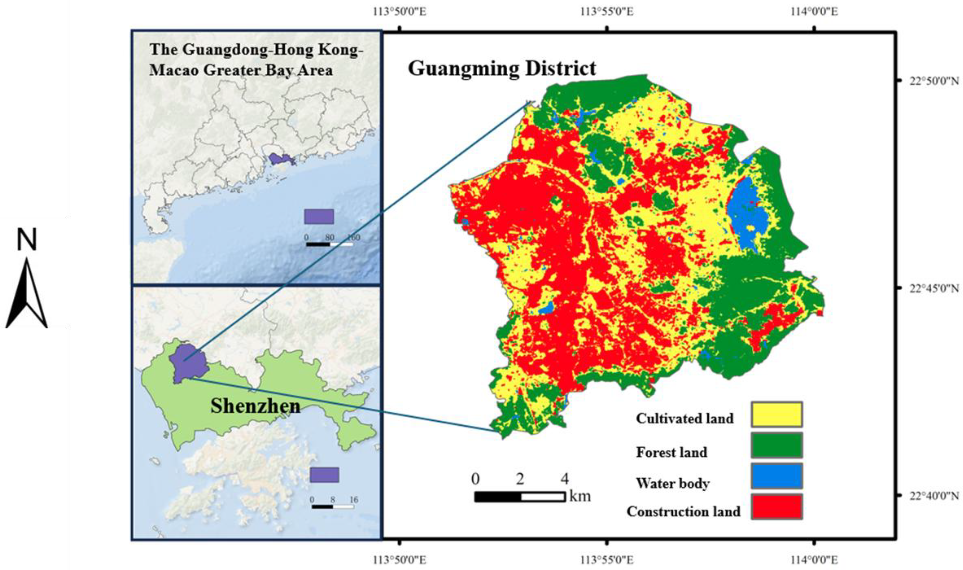
Guangming District, located in the northwestern part of Shenzhen, has undergone three major stages of development: a state-run farm, a new district, and an administrative district. Its geographic coordinates are 22°46′34″ N and 113°54′44″ E. It borders Guanlan Subdistrict in Longhua District to the east, Shiyan Subdistrict in Bao’an District to the south, Songgang Subdistrict in Bao’an District to the west, and Dongguan City to the north. Guangming District enjoys a distinct locational advantage as a key node within both the Guangdong–Hong Kong–Macao Greater Bay Area and the Guangzhou–Shenzhen–Hong Kong–Macao Science and Technology Innovation Corridor. Its predecessor, Guangming New District, was established in August 2007 as Shenzhen’s first functional new district, governing two subdistricts: Guangming and Gongming. In May 2018, Guangming New District was upgraded to a full administrative district of Shenzhen—Guangming District—comprising six subdistricts: Guangming, Gongming, Xinhu, Fenghuang, Yutang, and Matian, with a total of 37 communities. The district covers an area of 155.38 square kilometers, of which Guangming Science City accounts for about 99 square kilometers, roughly two-thirds of the total area. As of March 2025, the resident population was approximately 1.159 million, including about 243,300 registered residents. Please see Figure 1.

2.2. Integration of Path Dependence Theory: The Policy-Driven “Lock-In–Unlock” Mechanism

By incorporating path dependence theory into a dynamic feedback model, this study analyzes how policies achieve “path lock-in” and “path unlocking” at different stages, forming a “policy–network–space” coordinated lock-in–unlock logic.
Using a timeline to connect the three stages of Guangming District—Planned Economy, Reform and Opening-up, and Innovation and Transformation—this study demonstrates how policies, through policy–network–space coordination, realize both path lock-in and path unlocking. At its core, this reflects the dynamic process through which policy breaks multi-dimensional lock-ins.
This section examines the evolution of the urban functional positioning of Guangming District, Shenzhen, since the 1950s, with an in-depth analysis of the key policies (at the national, provincial, municipal, and district levels) and their backgrounds that drove each shift in functional positioning. Drawing on policy texts such as successive planning documents and government work reports of Guangdong Province, Shenzhen Municipality, and Guangming District, it systematically reviews and explains changes in Guangming District’s urban functional positioning from the perspectives of urban development goals, industrial functional orientation, and regional functional roles, comprehensively presenting the evolutionary process through which Guangming District has moved from the periphery toward the center with continuously upgraded development capacity.
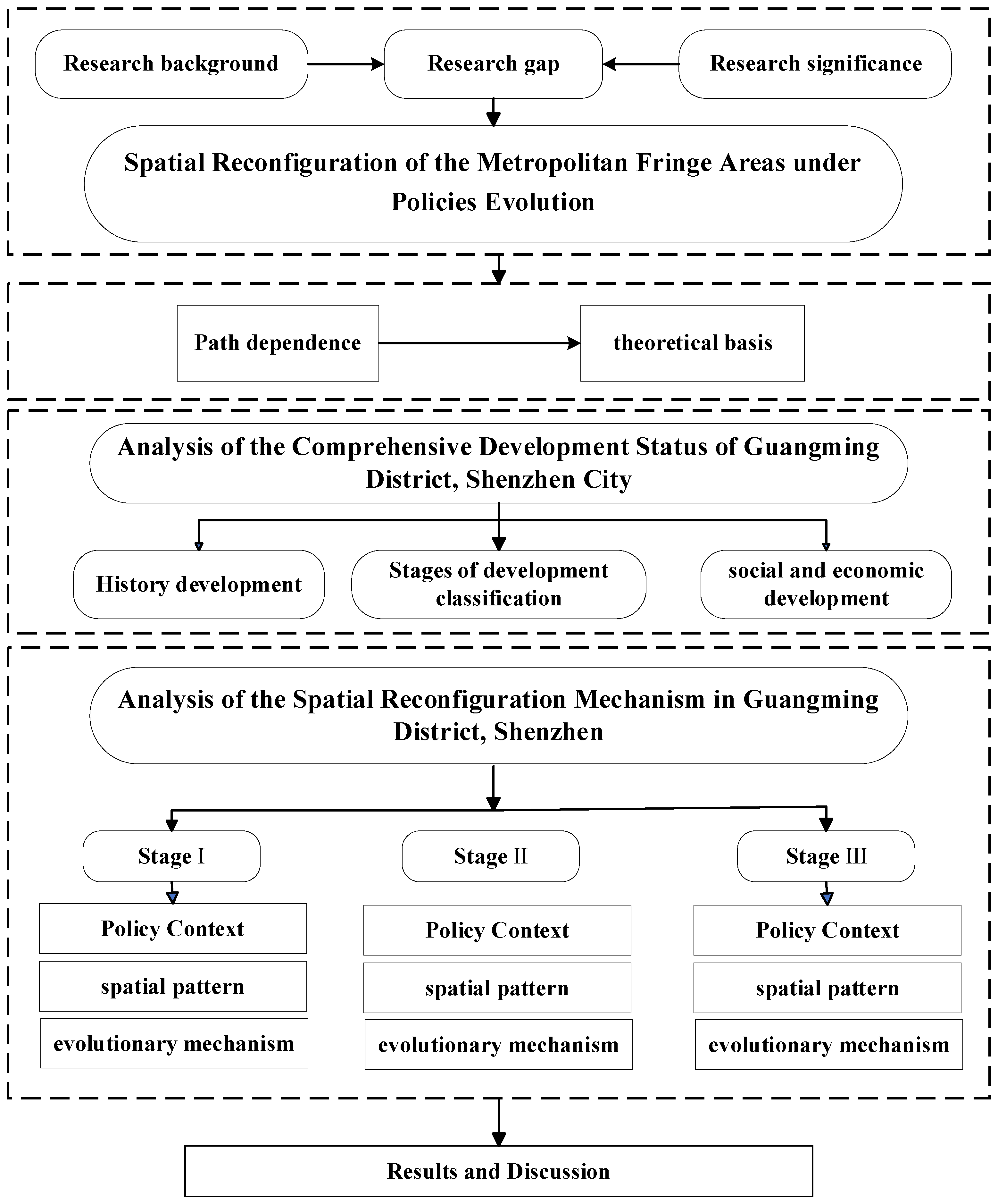
Based on the core concepts of path dependence theory and grounded in the historical evolution of Guangming District, Shenzhen, this section explores its typicality and representativeness as a metropolitan peripheral area. Guangming District is divided into three stages—1958–1980, 1981–2007, and 2008 to the present—and the spatial morphology, socioeconomic development, and industrial structure of each stage are examined respectively. Through a stage-by-stage analysis, this part investigates the impacts of policy evolution on spatial restructuring and their interaction mechanisms. The research framework is shown in Figure 2.
This study is driven by “policy evolution”, and results in “space reconfiguration”. This forms a closed-loop feedback mechanism of “policy → space → policy” model. This model presents the dynamic feedback relationship among “policy evolution” and “spatial reconfiguration” using bidirectional arrows. The core logic is “policy drives spatial adjustment, and space provides feedback for policy optimization”. The specific structure is as follows:
The policy evolution is divided into “national strategic layer” (such as agricultural reclamation policies, science city strategies) and “local layer” (such as land policies, industrial subsidies). Through three paths of “strategic positioning guidance”, “factor cost regulation” and “innovation resource aggregation”, it outputs driving forces towards “space reconfiguration”.
The “space reconfiguration” covers four dimensions: “land use”, “industrial space”, “population space” and “infrastructure”. The newly formed “new spatial endowment” (such as contiguous scientific research land, mature industrial clusters) is used to optimize policies through “resource constraint feedback” and “efficiency demand feedback”.

2.3. Methods

This study is based on two main analytical methods (the Moran Index and the Aggregation Index) to explain the quantitative results of the clustering situation of enterprise and land-use change in Guangming District from 1980 to 2024.

2.3.1. Moran’s I Index

Moran’s I index is a classic statistical measure used to quantify spatial autocorrelation, capturing the degree to which attribute values of spatial units are clustered or dispersed across space. Its calculation formula is as follows:
I = n i j w i j i j w i j ( x i x ¯ ) ( x j x ¯ ) i ( x i x ¯ ) 2
where n denotes the total number of spatial units; xi and xj represent the attribute values of units i and j, respectively; x ¯ is the mean of the attribute; and wij is the spatial weight matrix, indicating spatial proximity relationships (e.g., contiguity or distance). The theoretical range of Moran’s I is: −1 ≤ I ≤ 1.
  • I > 0: Positive spatial autocorrelation, indicating spatial clustering of similar values (high values adjacent to high values, low values adjacent to low values);
  • I < 0: Negative spatial autocorrelation, indicating spatial dispersion (high values adjacent to low values);
  • I ≈ 0: Random distribution, with no significant spatial structure.
To further identify local spatial patterns, the local Moran’s I can be applied:
I i = ( x i x ¯ ) j w i j ( x j x ¯ )
This index is used to classify types of local spatial clustering:
  • High–High (HH): Hot spots;
  • Low–Low (LL): Cold spots;
  • High–Low (HL): High-value outliers;
  • Low–High (LH): Low-value outliers.

2.3.2. The Aggregation Index (AI)

The Aggregation Index (AI) is an important metric used to measure the degree of aggregation of patches of a given class within a landscape, reflecting the spatial adjacency of similar pixels. Its calculation formula is as follows:
A I = g i i g i i m a x × 100
where gii denotes the number of like adjacencies between pixels of class i, and g i i m a x represents the theoretical maximum number of such adjacencies under the condition that the area of the class remains constant.
The value of AI ranges from 0 to 100. As AI → 0, the class is highly fragmented, with pixels isolated from each other; as AI → 100, the class is highly aggregated, approaching a single contiguous patch.

3. Results

3.1. Formation and Lock-In of the “Dual-Track” Agricultural Path (1958–1980)

From the late 1950s to the early 1980s, the two main spatial areas of Guangming District, Guangming Farm and Gongming Commune, were governed under two distinct policy systems of the planned economy era, forming a farm–commune dual system within the same location. Although both followed a planned agricultural economic model, their policy institutions were completely different (Table 1): Guangming Farm was dominated by the state-run farm system, while Gongming Commune was governed by the people’s commune system. These two institutional types created spatial differentiation in adjacent areas of Guangming District, and the policy differences directly locked in subsequent development paths.
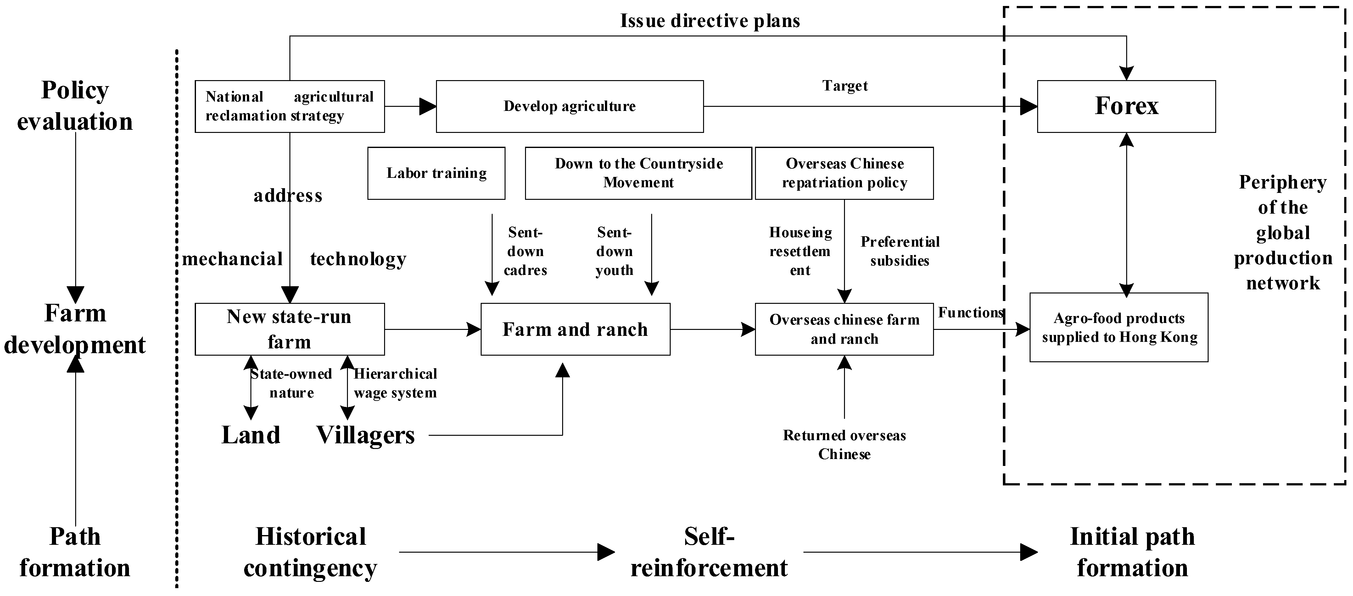
The Hong Kong-oriented agricultural and sideline product path of Guangming Farm originated from historical contingencies and policy anchoring in national strategy. It was subsequently reinforced through path dependence in policy, technology, and spatial organization, ultimately forming an outward-oriented, export-focused agricultural production path under the planned economy system (Figure 3).
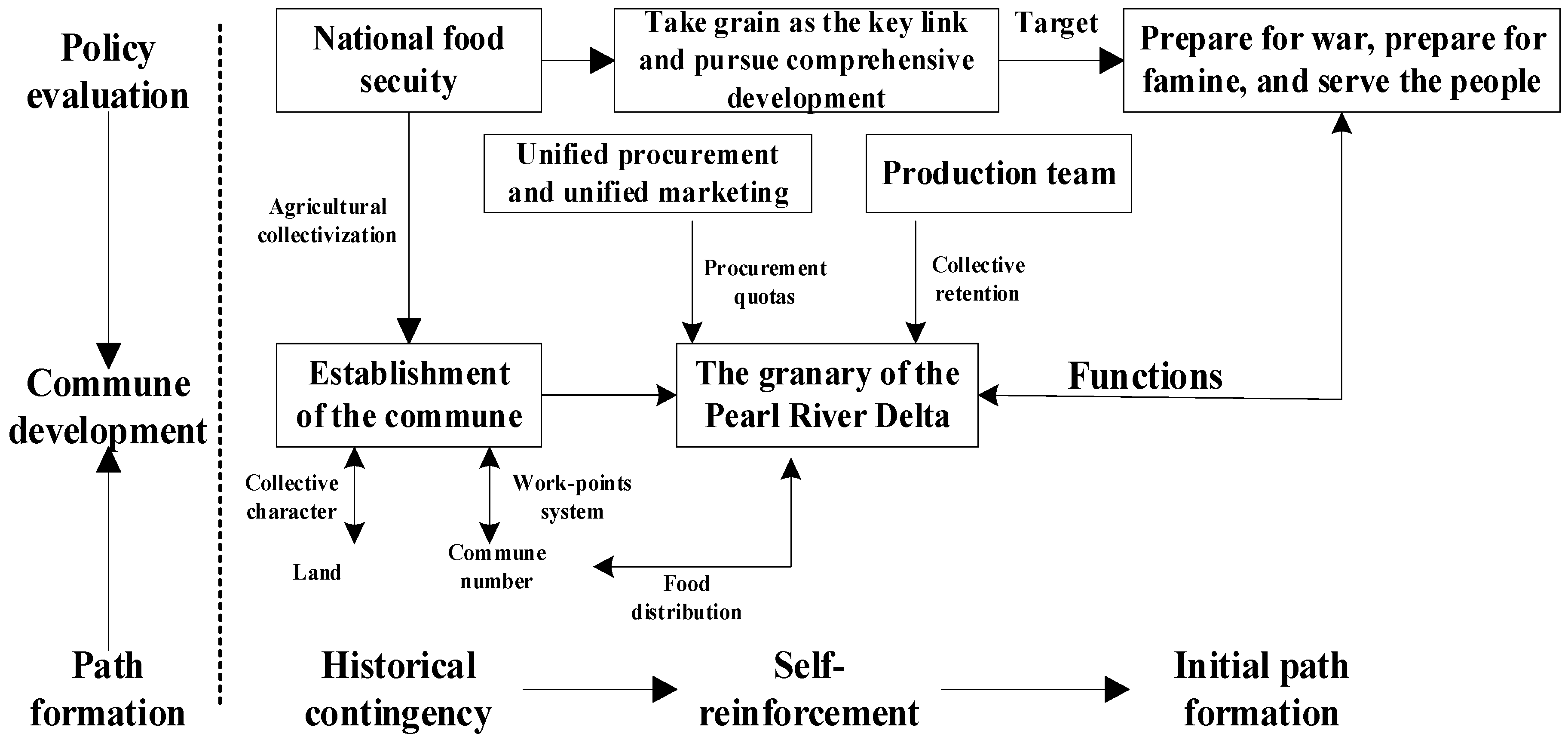
Unlike Guangming Farm during the same period, Gongming Commune evolved along the mainstream path of the planned economy era (Figure 4). In October 1958, Gongming Township, Songgang Township, and Guangming Farm were combined to form Guangming Commune. In July 1961, Gongming Township was established as a separate Gongming Commune. From then until its restructuring in 1983, the Gongming Commune system continued to operate. Following its independent establishment in 1961, the state anchored Gongming Commune as a core component of Bao’an’s grain reserve through policies of unified purchase and sale and the three-tier ownership system, with its path entirely serving domestic food self-sufficiency.
Policy constraints further reinforced path dependence through household registration barriers and internal networks. Under the national grain procurement policy, the hukou (household registration) system restricted labor mobility, preventing commune members from migrating to cities or state farms; population growth thus relied primarily on natural increase. Within the limits allowed by the planned economy, collective sideline industries (such as pig farming and weaving) and small commune- or brigade-run enterprises (such as tool factories and brick kilns) were developed to supplement income through non-agricultural activities. However, their scale and technological level remained low, still embedded within the collective ownership structure. After Bao’an County was upgraded to Shenzhen City in 1979, a small number of farmers began experimenting with township industries, yet prior to 1980 agriculture remained the dominant sector, and labor was largely unable to shift into higher value-added activities. This resulted in a closed-loop dependency among farmers, land, and grain production.
In the late 1970s, the commune attempted to break its path lock-in, for example, by allowing farmers to sell surplus products and to engage in market trading, but due to policy constraints and entrenched path dependence, the adjustments had limited impact. After fulfilling state procurement quotas, farmers in Gongming Commune could sell small amounts of vegetables and poultry, yet these activities failed to develop into a market-oriented industry. Individual handicrafts such as weaving and tool repair involved fewer than a hundred people and did not break away from the agriculture-dominated path.
Because collective property rights, procurement obligations, and the hukou system remained fundamentally unchanged, farmers lacked incentives for transformation—for instance, cultivating cash crops involved significant policy risks. As a result, these efforts served only as supplements to the planned economy, failing to integrate the commune into external networks and instead reinforcing a path dependence characterized by closed self-sufficiency.
At this stage, the land use in the prosperous areas was mainly for agricultural production. Constrained by both the nature of land ownership and the directives of the planned economy, this resulted in different spatial patterns: the concentrated farmland space of the Guangming Farm and the scattered farmland space of the Gongming Commune.
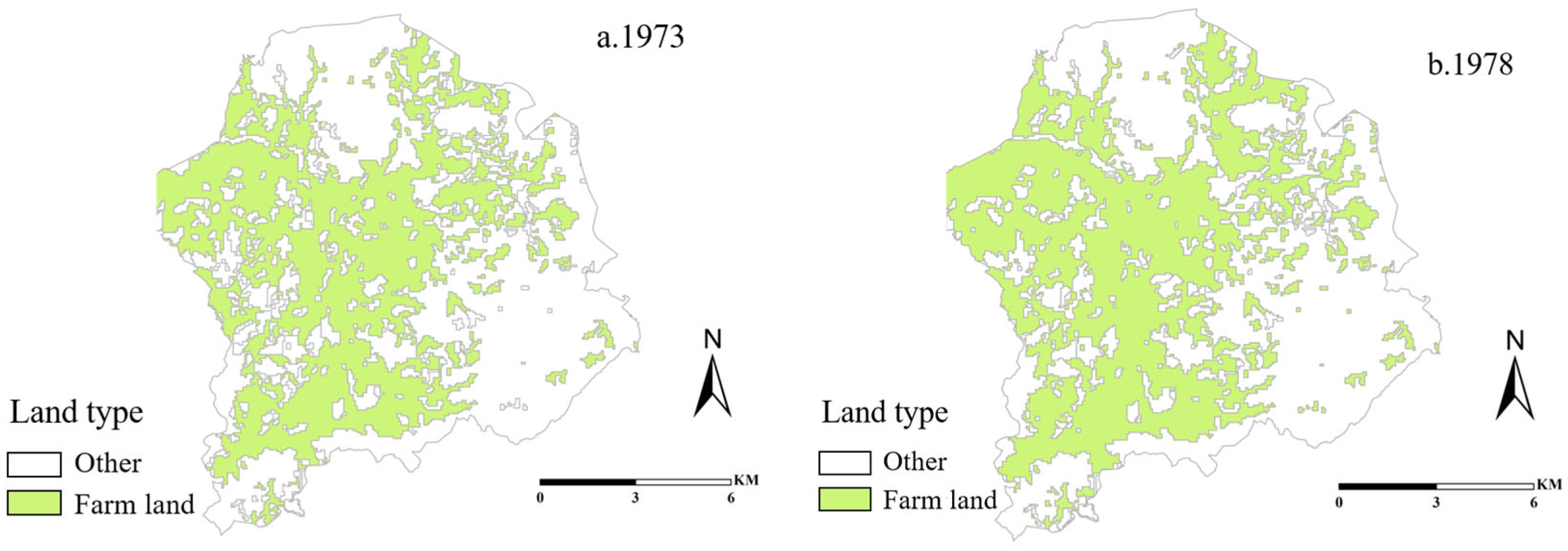
Driven by the agricultural economy, the land use space in Guangming District during this period was mainly dominated by agricultural cultivation. Therefore, farmland became the primary agricultural production space to meet the demand for food production. Based on the historical remote sensing images available for Guangming District at present, the earliest image records can be traced back to 1973. Additionally, the remote sensing images from the late 1970s to the early 1980s were analyzed. The image data from 1978 was relatively clear, so the remote sensing image data from 1978 was selected for the analysis at the end of this period. From Figure 5a,b, it can be seen that the spatial distribution of farmland in 1973 and 1978 was relatively concentrated and stable, and was mainly used for agricultural production activities.
In 1973, agricultural and forestry land covered approximately 141.5 km2, accounting for over 90% of the total area. Among this, farmland totaled about 65.9 km2, representing approximately 42.3%. Arable land included both paddy fields (dependent on reservoir irrigation) and dry farmland (relying on natural rainfall).

3.2. Formation and Reinforcement of a Heterogeneous Space of Coexisting Agriculture and Industry (1981–2007)

In the late 1970s, profound changes took place in the international landscape: peace and development gradually became the dominant themes of the era, and the trend of economic globalization began to emerge. At that time, China’s economy was facing severe challenges. Against this backdrop, the state adopted the policy of emancipating the mind as a breakthrough. At the Third Plenary Session of the 11th Central Committee of the Communist Party of China in 1978, a historic decision was made to shift the Party’s focus toward socialist modernization, marking the beginning of the great journey of reform and opening-up.
The reform and opening-up strategy encompassed both domestic institutional reform and external economic liberalization, with the overarching objective of liberating and developing the productive forces and advancing national modernization. In 1980, amid this reform wave, Special Economic Zones (SEZs) such as Shenzhen were officially established, positioning them at the forefront of China’s integration into the global economy. To fully leverage China’s abundant labor and land resources, attract foreign capital, and promote an export-oriented development model, the central government granted Shenzhen a series of preferential policies, including tax incentives and streamlined approval procedures for foreign investment. These measures triggered a substantial inflow of foreign capital.
Concurrently, the “Three Plus One” model (Sanlai Yibu) emerged as a distinctive form of early foreign direct investment. This model encompasses four arrangements: processing with supplied materials, processing with supplied samples, assembly with supplied parts, and compensation trade. In the first three arrangements (the “Three Plus”), foreign firms functioned as clients while Chinese enterprises acted as contractors. Under contractual agreements, Chinese firms received raw or auxiliary materials, samples, packaging materials, components, or technologies from foreign partners, processed or assembled them into finished products, and returned the outputs to the clients, earning processing fees while assuming minimal market risk. The “One Compensation” arrangement—compensation trade—was based on credit agreements, whereby one party imported equipment or technology and repaid the associated costs over an agreed period through product output or labor services.
Between 1981 and 2007, the geographical boundaries of Guangming Farm and Guangming Commune did not change significantly, but Guangming Farm underwent several rounds of institutional reform. In March 1999, an administrative separation of government and enterprise was implemented, and Guangming Overseas Chinese Livestock Farm was placed under the management of Shenzhen Commerce and Trade Holding Company, becoming a first-tier state-owned enterprise directly under the municipality. In October of the same year, the Party Committee and Office of Guangming Subdistrict were officially established, taking over the social management functions previously held by the farm—marking the end of the historical era in which the farm both provided and managed social affairs. In 2002, the Overseas Chinese Farm administrative system, which had existed for nearly half a century, was formally abolished, and the remaining social management functions of Guangming Overseas Chinese Livestock Farm were further separated. Its economic entity was restructured into Guangming Group. For ease of identification and in line with common usage, this study continues to refer to the area as Guangming Farm when analyzing its development during this period.
In July 1983, the Gongming Commune was dissolved and restructured as Gongming District. It was later renamed Gongming Town in 1986 and then reorganized as Gongming Subdistrict in July 2004. During this stage, the primary administrative unit of the area was Gongming Town, and this study adopts the term “Gongming Town” when analyzing the region’s development.
During this period, driven by the policies of reform and opening-up, Guangming Farm and Gongming Town exhibited markedly different policy responses (Table 2). Benefiting from its institutional status as a state-owned farm and its long-established function as a supply base for agricultural and sideline products exported to Hong Kong, Guangming Farm was among the earliest actors to engage in outward-oriented economic experimentation. It pioneered the “Three-plus-one” model—processing with supplied materials, processing with supplied samples, assembly with supplied parts, and compensation trade—and attracted foreign investment primarily from Hong Kong. In contrast, the policy practices of Gongming Town displayed phased breakthroughs rather than an immediate transition, which can be divided into two distinct stages:
  • Between 1981 and around 1992, due to its designated role as an agricultural zone, Gongming Town was strictly restricted from developing “Three-plus-one” manufacturing industries. As a result, it missed the first wave of foreign investment dominated by Hong Kong capital, and its economy remained centered on a smallholder agricultural structure.
  • From around 1992 to 2007, driven and negotiated by various actors such as local governments and village collectives, Gongming Town seized the momentum created by Deng Xiaoping’s 1992 Southern Tour and caught up with the wave of “Three-plus-one” manufacturing industries led mainly by Taiwanese investment. The town focused on developing the electronic information manufacturing sector, which not only facilitated Gongming’s economic transformation but also laid the initial industrial foundation for the later innovation-driven development of Guangming Science City.
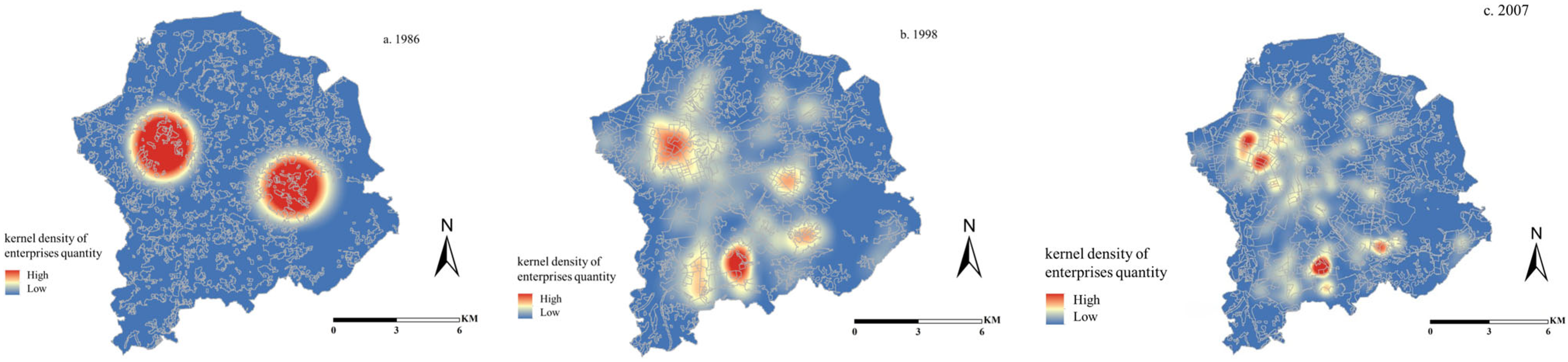
After the reform and opening up, Shenzhen was like a kindling spark that quickly initiated the process of industrialization and urbanization. Although the Guangming area was part of Shenzhen, due to its location in the outer edge area, its early industrial development was relatively slow. As can be seen from Figure 6a, in 1986, the number of enterprises in Guangming was very limited, with only scattered distribution in the central area of Gongming Town and the office area of Guangming Farm. At this time, there were differences in the institutional mechanisms between Guangming Farm and Gongming Town, and the two were loosely connected, each forming an independent industrial center, thus constituting the early dual-center pattern.
In the late 1990s, as shown in Figure 6b, the industrial layout of Guangming District underwent significant changes. In addition to the original central area of Gongming Town (now Gongming Street) and the farm’s headquarters (now Guangming Street), the areas currently belonging to Ma Tian Street and Feng Huang Street, etc. also saw a significant increase in the number of enterprises, forming multiple industrial centers and a multi-center structure. During this period, “three-in-one and one-supply” manufacturing enterprises were widely spread, and the development model of “villages lighting up one by one and households emitting smoke” became increasingly prominent. The entire Guangming District was filled with an industrial atmosphere.
Entering the new millennium, based on the strategic planning and development considerations for urban development, Shenzhen began to impose strict restrictions on land use, shifting the focus of development to high-tech industries and striving to build Guangming High-tech Zone (now Fenghuang Sub-district). This policy was like a powerful magnet, attracting enterprises to concentrate in specific areas. At this time, the central area of Gongming Town (now Gongming Sub-district) and Guangming High-tech Zone (now Fenghuang Sub-district) became the core areas where enterprises gathered, forming two concentrated areas with distinct industrial advantages, once again reshaping the new dual industrial center pattern, see Figure 6c.
In 1981, the residential land in Guangming District was mainly composed of scattered, widely distributed throughout the area. The land area was small and fragmented. This was related to the fact that Guangming District was mainly based on agricultural economy at that time (such as Guangming Overseas Chinese Farm, which was responsible for providing agricultural and sideline products and other functions), with low population concentration and scattered residential demands.
With development of the Shenzhen Special Economic Zone and attracted population inflow to the surrounding areas, and the township enterprises in Guangming District (such as processing factories for imported materials) began to develop initially, attracting some migrant workers, which led to an increase in residential demand.
From 1993 to 2003, the overall urbanization of Shenzhen accelerated, the industrial structure of Guangming District adjusted (such as the growth of “three-in-one and one-supplement” industries), employment opportunities increased, and the population rapidly concentrated.
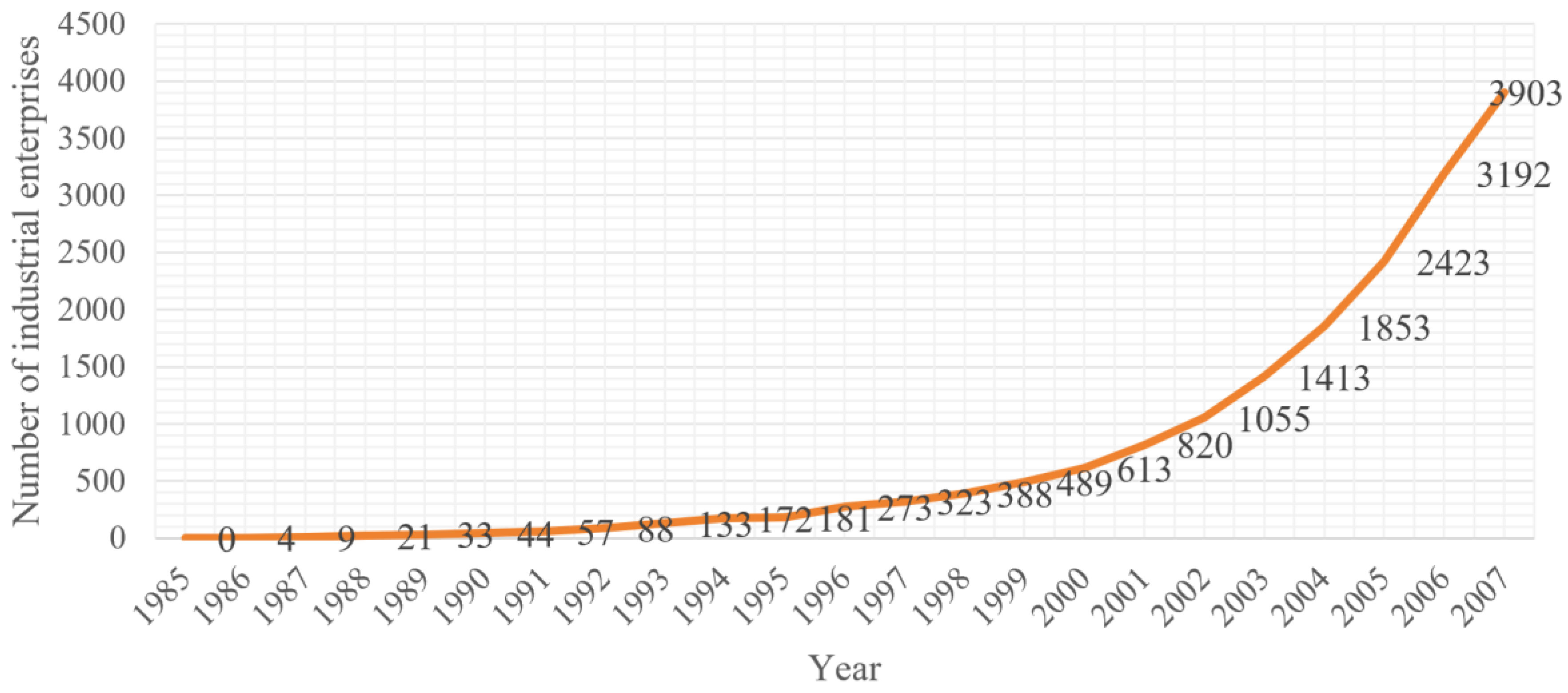
After Deng Xiaoping’s Southern Tour speeches in 1992, local governments adjusted agricultural policies in Gongming Town and began to promote the development of “three supplies and one compensation” processing industries. From 1992 onward, Gongming Town moved beyond the constraints of an agriculture-based economy and established a development strategy that retained agriculture as its foundation while vigorously advancing industrialization. The town put forward the policy of “five wheels in motion,” encompassing foreign-funded enterprises (“three types of capital”), “three supplies and one compensation” processing, self-operated enterprises, internal economic linkages, and private businesses, and actively pursued investment attraction (see Figure 7).

3.3. The Cluster Path and Breakthrough of Emerging and Traditional Industries (2008–2025)

In May 2007, the State Council officially approved the establishment of Guangming New District, making it Shenzhen’s first functional district. After its founding, the New District focused on advancing infrastructure development and industrial planning, attracting the settlement of high-tech enterprises. After 2010, Guangming New District entered a period of rapid development, emphasizing industries such as next-generation information technology and biomedicine, while continuously improving transportation, education, and other supporting facilities. In September 2018, the Guangming Administrative District was formally established, further institutionalizing this development trajectory.
Over more than forty years of reform and opening-up, Guangming District has experienced rapid economic growth. However, facing intensifying international competition in high-tech fields under new circumstances, Guangming’s development orientation has undergone a “triple leap”—from a “high-tech industrial park,” to a “world-class science city and northern center of Shenzhen,” and further to the “pilot zone of the Greater Bay Area Comprehensive National Science Center,” marking an upgrade from a municipal-level strategy to a national-level one. Please see Table 3.
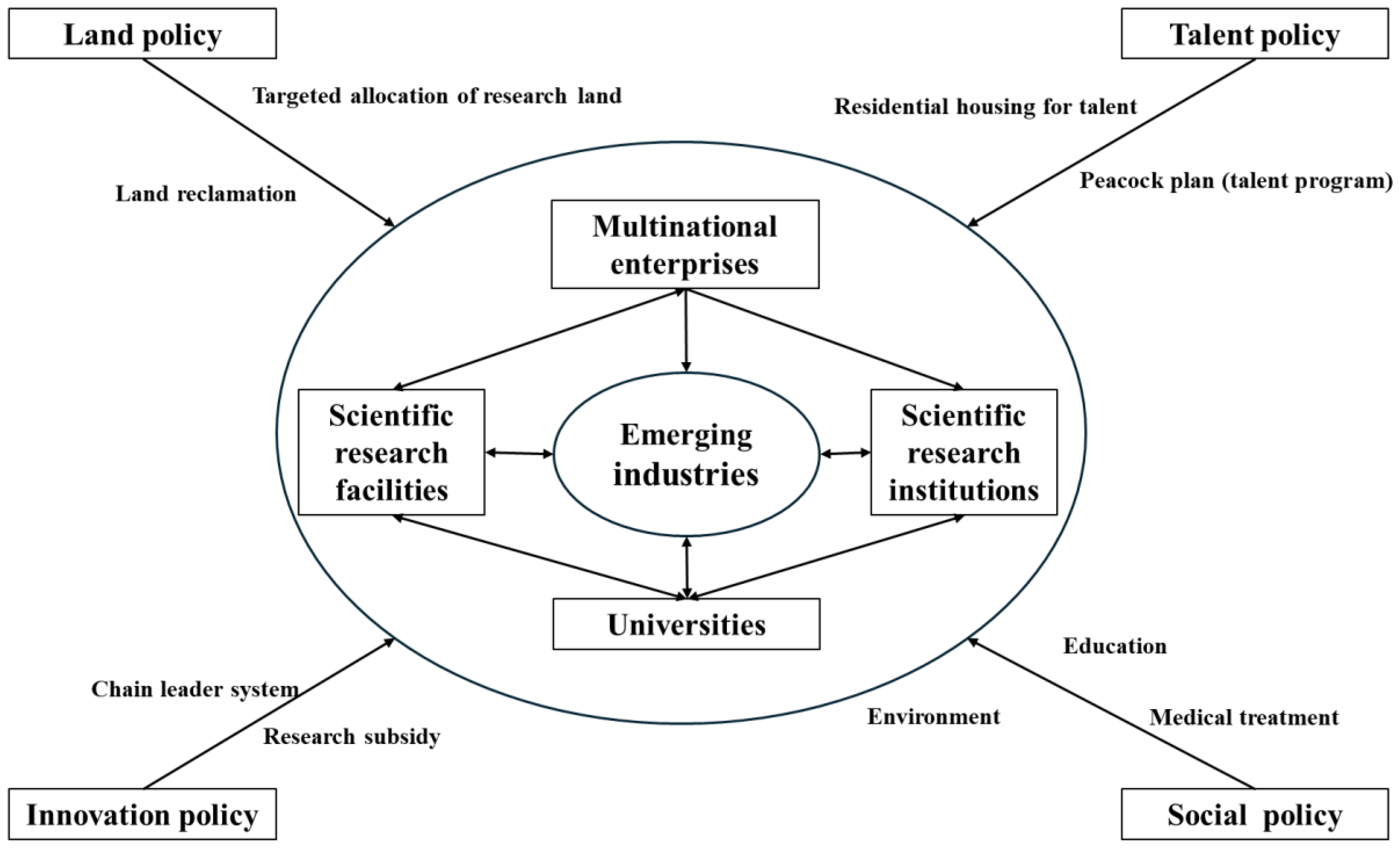
After the establishment of Guangming New District in 2008—and especially following its upgrade to Guangming District in 2018—the region faced traditional path dependencies formed during the reform and opening-up period, such as “dependence on low-end manufacturing,” “extensive land use,” and “factor-driven growth.” Through multiple mechanisms—“institutional unlocking” via policy hierarchy elevation, “value chain upgrading” through industrial policy restructuring, and “knowledge embedding” through innovation in factor policies—the district has promoted a transition from a “path dependence trap” to an “innovation-driven path.” The core logic lies in the innovative use of policy instruments to reconstruct the coupling among factor allocation, industrial organization, and spatial function (see Figure 8).
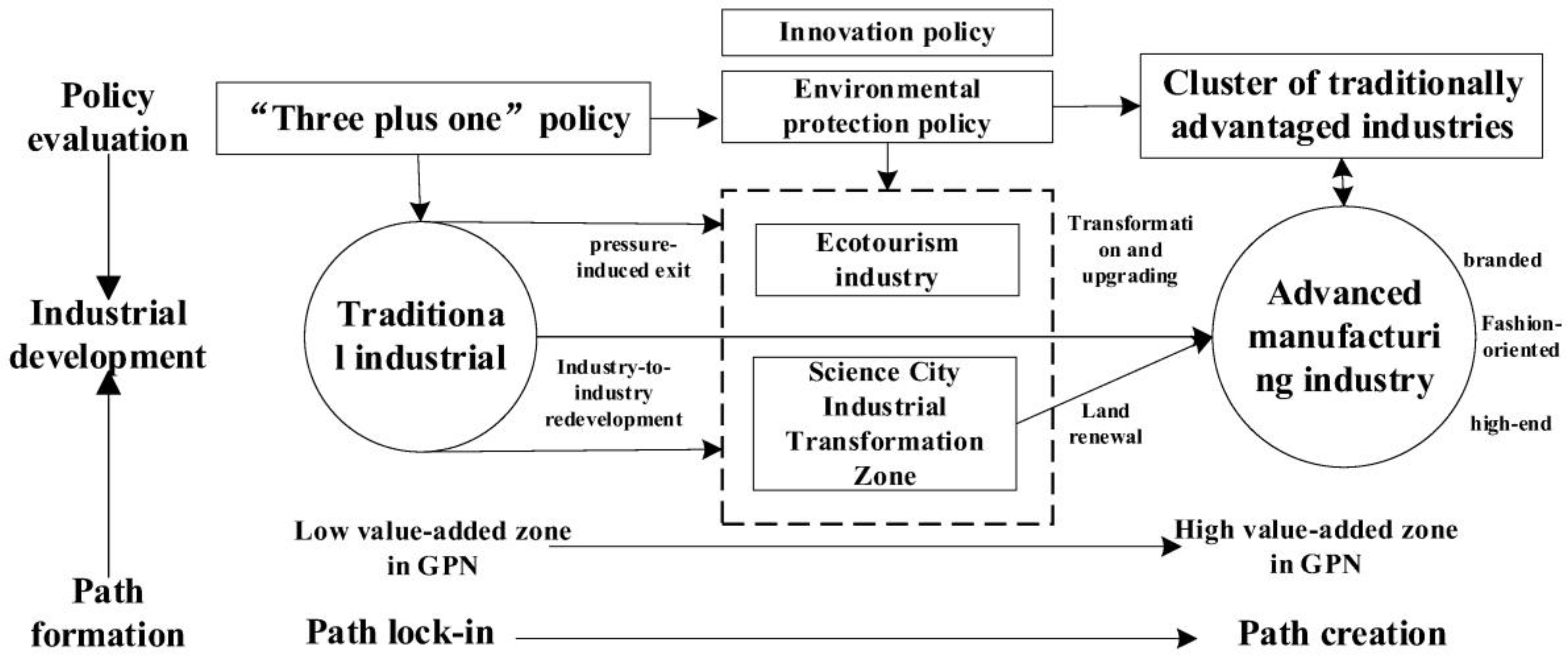
Traditional industries—such as hardware and plastics, mold manufacturing, and garment production—represent the “path legacy” of Guangming District’s development before 2007. As of 2024, these sectors still account for 38% of enterprises above the designated size. However, aggressive elimination would risk triggering social issues such as “job loss” and “spatial vacancy.” In response, policies for traditional industries follow the logic of “adaptive reconstruction of path dependence.” Through three main approaches—“redevelopment of existing spaces,” “environmental pressure–driven phase-out,” and “functional alignment with the Science City”—the district seeks to achieve a transformation from “breaking low-end lock-in” to “activating stock value” and “adapting to emerging functions.” This strategy prevents systemic risks that could arise from abrupt path rupture (see Figure 9).
In response to the lock-in of traditional industrial spaces characterized by low floor-area ratios, mono-functional uses, and obsolete facilities, policy interventions have focused on restructuring existing industrial stock through instruments such as industrial-to-industrial redevelopment (gong gai gong) and industrial-to-affordable-housing conversion (gong gai bao). Through gong gai gong initiatives, dispersed and aging factories in Gongming and Yutang have been consolidated into specialized industrial parks for mold and underwear manufacturing, with floor-area ratios increased from 1.2 to 3.5. The introduction of advanced technologies, including CNC machining and 3D printing, has raised the share of high-end products in the mold industry to 45% by 2024 and enabled the provision of precision components for leading firms such as China Star Optoelectronics. Collectively, these measures have facilitated a transition toward spatial intensification and functional adaptation.
To address the path lock-in of traditional industries characterized by high energy consumption and high pollution, policy interventions have pursued gradual unlocking through instruments such as tiered environmental standards and exit buffer mechanisms. Measures including differentiated electricity pricing and support for adaptation to carbon-border regulations have compelled traditional industries to undertake green upgrading. For example, Xinxing Light Alloy developed low-carbon production technologies and incorporated relevant standards into ISO certification. Following the exit of the Gongming printing and dyeing plant, the site was redeveloped into a synthetic biology industrial park, while former employees transitioned into positions such as park administrators through job-transition training. This process enabled a smooth transition of “industrial exit–workforce transformation–spatial regeneration,” thereby mitigating the social risks associated with abrupt path rupture.
In terms of industrial space, the region has undergone a transformation from “dispersed manufacturing” to an “east R&D–west manufacturing” (dong yan–xi chan) configuration, in which emerging industrial clusters (such as ultra-high-definition displays and new materials) and traditional industrial clusters (such as molds and underwear) have developed in a coordinated manner. By 2024, strategic emerging industries accounted for 57.8% of GDP, signaling a shift from dispersed production toward cluster-based innovation. First, the clustering of emerging industries has been largely realized through the establishment of an “8+5” industrial cluster system (eight strategic emerging industries plus five future industries). Sectors such as ultra-high-definition display manufacturing (with an output value exceeding RMB 200 billion), new materials (over RMB 80 billion), and biomedicine (over RMB 3.8 billion) exhibit clear patterns of core agglomeration and value-chain extension. In 2024, the value added of strategic emerging industries reached 57.8% of GDP, positioning them as the region’s primary spatial growth pole. Second, traditional industrial agglomerations have been significantly upgraded. Sectors including hardware and plastics, molds, and underwear have shifted from citywide dispersion to localized clustering, forming major traditional industry clusters in Matian Subdistrict (underwear and watches) and Yutang Subdistrict (molds). Through industrial-to-industrial redevelopment and design-driven upgrading, these sectors achieved notable technological advancement; by 2024, high-end products accounted for 45% of traditional industrial output. As a result, traditional industries have developed supporting and complementary relationships with emerging industries—for example, the mold industry supplying precision components to the ultra-high-definition display sector. Third, a spatial division of labor characterized by “east R&D–west manufacturing” has taken shape, demarcated by the Longda Expressway. The eastern area (Xinhu and Guangming subdistricts), anchored by Guangming Science City, has evolved into an “innovation source zone,” concentrating more than 60% of research institutions, major scientific facilities, and technology enterprises. In contrast, the western area (Yutang and Matian subdistricts) has emerged as an “advanced manufacturing zone,” undertaking pilot testing and large-scale production based on eastern R&D outputs. In 2024, the western area contributed 55% of total industrial output, demonstrating effective spatial synergy between innovation and manufacturing.
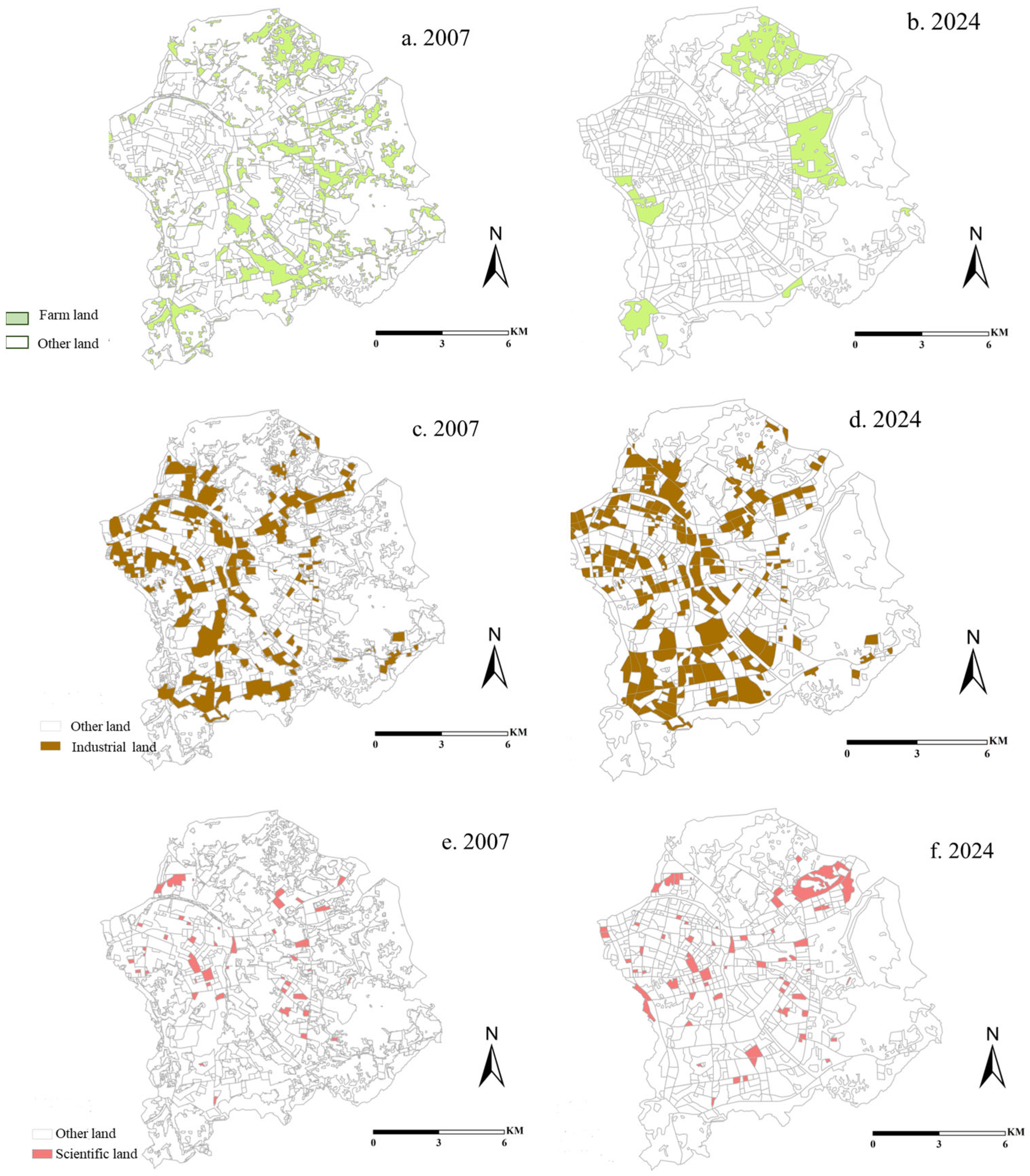
In terms of land use, the area has transitioned from “extensive industrial land use” to “innovation-oriented intensive use.” By 2024, land designated for scientific research accounted for 15% of total land use, industrial land-use efficiency had increased by 3.75 times, and ecological land comprised 28% of the total area. First, land for scientific research has evolved from near absence to spatial concentration. The proportion of research land increased from 0.5% in 2007 to 15% in 2024, giving rise to the Gongchang Road Scientific Research Corridor, which clusters more than 120 research entities, including the Shenzhen campus of Sun Yat-sen University and the Shenzhen Bay Laboratory. This shift reflects a fundamental reorientation of land use from a production-oriented to an innovation-oriented pattern. Second, industrial land has undergone “quality upgrading with reduced quantity.” While the total area of industrial land declined from 45 km2 in 2007 to 38 km2 in 2024, the floor-area ratio increased from 1.2 to 3.5. Through industrial-to-industrial redevelopment (gong gai gong), approximately 1.2 million m2 of space for high-end industries was released. As a result, land output efficiency rose from RMB 1.2 billion per km2 in 2007 to RMB 4.5 billion per km2 in 2024. Third, farmland has experienced “peripheral concentration” alongside the restoration of ecological space. Farmland area decreased from 28 km2 in 2007 to 12 km2 in 2024, shifting from fragmented, citywide distribution to concentrated peripheral zones, mainly in the southern part of Guangming Subdistrict. Simultaneously, the Maozhou River was transformed from a heavily polluted waterway into a wetland landscape, accompanied by the establishment of ecological buffers such as Shiyan Wetland Park and Dayan Mountain Forest Park. Consequently, ecological land now accounts for 28% of the total area, forming a composite spatial structure integrating scientific research, industry, and ecology. See Figure 10.
This study employs FRAGSTATS to calculate the Aggregation Index for different years and land-use types in Guangming District. The results are as follows in Table 4:
From Table 4, we can see the aggregation index in farm/industrial and Scientific land became large from 1986 to 2024. Aligned with Figure 10, they explain that the land use in different types start to form a block in four decades.
Policies have broken the “factor-driven, industry-dominated” path dependence that had formed between 1981 and 2007 through a dual mechanism of “national strategic empowerment + local adaptive innovation.” First, national-level strategic upgrading: Guangming District was incorporated into major national strategies such as the Guangdong–Hong Kong–Macao Greater Bay Area and the Pilot Demonstration Zone, and was designated as a core area of the International Science and Technology Innovation Center. By deploying policy instruments such as large scientific facilities and dedicated research land quotas, these strategies dismantled rigidities such as the “industrial land fixation” and “absence of innovation functions,” providing strategic legitimacy for spatial reconstruction. Second, local government flexibility and adaptation: The district introduced innovative policies such as mixed-use zoning, the “chain-leader system,” and R&D subsidies to reduce institutional transaction costs. For example, the mixed-use land policy allows integrated development of research, residential, and commercial functions, breaking traditional land-use restrictions; the chain-leader system coordinates spatial layouts along industrial supply chains, preventing disordered competition and enabling more efficient spatial resource allocation.
As can be seen from Figure 11a,b, during the period from 2007 to 2012, although the number of enterprises increased, the spatial distribution pattern did not undergo significant changes. The enterprises were mainly concentrated in the several core areas that were developed earlier, and the scope and density of their clustering remained relatively stable. This indicates that during this stage, the spatial development pattern of enterprises in Guangming District had a certain continuity. There was no large-scale relocation of enterprises or formation of new large-scale clustering areas. This characteristic was closely related to the development stage of Guangming District at that time. In the early stage of the establishment of Guangming New District, the industries were mainly traditional manufacturing, and they had strong dependence on infrastructure and supporting facilities. Enterprises tended to be located in mature areas, and the spatial expansion motivation was relatively weak. The formation of Guangming District’s “east for research, west for production” pattern reflects a spatial transition in regional development—from scale expansion to quality and efficiency enhancement, and from disorderly agglomeration to orderly functional division of labor.
From 2012 to 2018, as shown in Figure 11b,c, the spatial agglomeration of enterprises exhibited a dual pattern of core expansion and spatial enlargement. On the one hand, supported by improved infrastructure and favorable policies, the existing agglomeration cores expanded in both extent and density, indicating a strengthening of their attractiveness and agglomeration capacity and drawing an increasing number of enterprises into these areas. On the other hand, several new, small-scale agglomeration centers emerged, suggesting that, with ongoing regional development, a broader range of areas had acquired the conditions necessary to attract firms. This reflects a spatial expansion of economic activity across the region.
From 2018 to 2024, as shown in Figure 11c,d, enterprise agglomeration was further intensified and refined. Not only did the existing agglomeration centers continue to expand and strengthen, but newly emerging agglomeration areas also matured, giving rise to a more complex and diversified spatial pattern of enterprise distribution. This evolution is closely associated with industrial upgrading in Guangming District, adjustments in urban planning, and the continued improvement of transportation and other infrastructure, which together have encouraged enterprises to reorganize their spatial layouts and pursue clustered development across different areas in line with their specific needs.
This study employs ArcMap to calculate the global Moran’s I of the number of enterprises in different years in Guangming District in Table 5. Also, we calculate the local Moran’s I of enterprise counts in Guangming District for different years, based on a 1000-m spatial grid; see Figure 12.

4. Discussions

Based on the development trajectory of Shenzhen’s Guangming District from 1958 to the present, a policy-driven “three-stage transition” pattern of spatial reconstruction can be clearly identified. Across these stages, policy instruments and spatial configurations exhibit a highly coupled and dynamic relationship, manifested as follows:
The evolution of Guangming District demonstrates the pattern of “initial anchoring –path reinforcement–lock-in crisis–policy unlocking.” Through a tri-dimensional toolkit encompassing institutions, technology, and space, policies have broken traditional path dependencies and facilitated the creation of new development trajectories.
This study finds that the formation and transformation of local development paths are not random processes, but the outcome of policy evolution and institutional influence. The case of Guangming District confirms the evolutionary logic of “contingent anchoring—path reinforcement—lock-in crisis—adaptive unlocking,” highlighting that policy institutions serve as the core variable in breaking path dependence.
(1)
The Formation Mechanism of Path Lock-in
Initial Anchoring during the Planned Economy Period: Guangming Farm’s positioning as a “Hong Kong-oriented agricultural base” and Gongming Commune’s role in “food self-sufficiency” formed rigid paths due to institutional complementarity (state-owned land—agricultural reclamation policies; collective land—people’s commune system). Guangming Farm relied heavily on state subsidies over the long term, while Gongming Commune was constrained by national grain procurement quotas.
Low-End Lock-in after Reform and Opening-Up: Gongming Town’s “Three-plus-one” model, driven by low land costs and abundant labor, created a dependence on contract manufacturing. By 2007, Taiwanese enterprises accounted for 60% of foreign-invested firms, but technological spillovers were limited. Guangming Farm’s industrial transformation lagged behind the Special Economic Zone’s core area due to land-use restrictions. The farm’s agricultural functions, combined with Shenzhen’s market-oriented reform goals, produced a technologically linked path dependence. During the innovation stage, these functions faced exit pressures due to environmental constraints, but the advantages of state-owned land also created opportunities for new development.
(2)
Policy-Driven Adaptive Unlocking: The Key Mechanism for Breaking Lock-In
After 2007, policy innovations—particularly the development of Guangming Science City—broke traditional paths through policy unlocking (e.g., changes in land use) and strategic re-coupling (integration into global innovation networks), creating a “local location opportunity window.” Policymakers actively identified global technology cycles (such as the rise in synthetic biology) and regional resource endowments (such as contiguous developable land) to drive path creation.
Institutional Unlocking: Through national-level strategic empowerment (e.g., incorporating Guangming Science City into the Greater Bay Area plan) and local policy innovations (such as mixed-use land pilots and the chain-leader system), restrictions on land use and industrial functions were broken. The proportion of research land increased from 0.5% in 2007 to 15% in 2024, while “industry-to-industry” redevelopment freed 1.2 million square meters for high-end projects.
Technological Unlocking: Leveraging large scientific facilities and R&D subsidies (up to 50 million RMB per project), industries shifted from “technology following” to “technology leading.” For example, BTR’s lithium battery anode materials maintained the highest global market share for 15 consecutive years, and synthetic biology enterprises accounted for 40% of newly established firms nationwide.
Spatial Unlocking: Through the “east-research, west-production” division of labor and ecological restoration, the coordination among production space, innovation space, and ecological space was achieved, raising the jobs–housing balance from 30% to 65%.
The Guangming District case illustrates how iterative policy tools can drive the role transition of peripheral areas within global networks, addressing the development challenges of urban peripheries under globalization and urbanization pressures. For instance: In the context of overlapping global uncertainty and urbanization pressures, how can metropolitan peripheries achieve adaptive spatial transitions through policy innovation? How can national policies, through iterative tools (e.g., from “land incentives” to “innovation empowerment”), promote a shift from low-end coupling to high-end coupling? Can policy-driven strategic coupling provide a new paradigm for developing countries to break free from global value chain dependence? Guangming District’s experience reveals the upgrade path of metropolitan peripheries within global networks.

5. Conclusions

As a typical case of transformation in a metropolitan peripheral area, Guangming District in Shenzhen offers evolutionary trajectories and practical experiences that are highly instructive for similar regions: (1) Providing policy insights for high-quality development in metropolitan peripheral areas. By analyzing Guangming’s practices of path dependence and path creation, as well as policy-driven unlocking and breakthrough, this study reveals how local governments can proactively engage with global production networks and global innovation chains through policy instruments, offering a paradigm for peripheral areas to shift from “passive absorption” to “active embedding.” For example, Guangming’s policy model of mixed land use for secondary and tertiary industries—which allows the integration of R&D and light manufacturing—has been incorporated into the Ministry of Natural Resources’ Guidelines for the Implementation of Industrial Land Policies, becoming a national exemplar of land system reform. Through policy-driven cluster building, Guangming has fostered industrial agglomeration via a combined approach of “guaranteed land supply for chain-leading enterprises + incubation subsidies for SMEs,” forming a mature ecosystem in the semiconductor display sector characterized by “leading enterprises as anchors and symbiotic supporting firms.” (2) Helping metropolitan peripheral areas overcome the “transformation trap”: Addressing the common challenges faced by peripheral areas, such as “low-end industrial lock-in” and “escalating social conflicts,” this research examines how Guangming District formulated policies to navigate the transformation of traditional industries while attracting emerging industrial clusters, thereby escaping the “transformation trap” and redefining the functional positioning of metropolitan peripheral areas. (3) Enhancing the international transferability of China’s regional development experience: Against the backdrop of de-globalization pressures and intensified inter-regional competition, the transformation practices of China’s metropolitan peripheral areas provide distinctive lessons for developing countries. Through the case of Guangming District, this study demonstrates the rapid mobilization and concentration of policy resources under the “concentrating resources to accomplish major tasks” governance system (e.g., the siting of national science centers), as well as its strong capacity to attract global high-end factors of production.
This study demonstrates how the national policy influences the metropolitan fringe area development; however, it still has several limitations. First, multi-scalar interactions are insufficiently addressed: by focusing only on Guangming District at a single-regional scale, it overlooks how domestic industrial chain coordination interacts with global networks under the “dual circulation” framework. For instance, the science–technology collaboration between Guangming and Songshan Lake in Dongguan, or the division of labor in the new energy industry across the Guangzhou–Shenzhen–Hong Kong–Macao innovation corridor—thereby limiting a full understanding of how peripheral areas bridge domestic and global networks. Second, policy time lags and spatial heterogeneity remain underexamined: policy impacts on spatial restructuring often exhibit a 5–10 year delay, yet available data cover only up to 2024, making it difficult to evaluate long-term effects; furthermore, differences in policy outcomes at the subdistrict scale (such as research clustering in Xinhu versus traditional upgrading in Matian) are not disaggregated, potentially obscuring the role of spatial endowments, because the database about the subdistrict were not created. Also, the national and local government made a lot of policies about Guanming district, which makes this district unique. Third, the resilience of Guangming’s global–local networks under rising global risks—including geopolitical tensions (e.g., technological decoupling) and carbon neutrality pressures on traditional industries—has not been explored, leaving open critical questions about how peripheral regions navigate the trade-off between efficiency and security. Future research should therefore undertake long-term tracking and micro-level analysis of policy effects, using 5–10 year panel data to verify the sustained industrial impacts of large scientific facilities and the chain-leader system, and, by integrating microdata at the subdistrict or park level, assess differentiated policy outcomes across varying industrial bases (industrial vs. agricultural) and spatial endowments (contiguous vs. fragmented land), thus providing evidence for more precise and adaptive policy interventions.

Author Contributions

Conceptualization, H.L.; methodology, H.L. and B.W. (Benshuo Wang); software, H.L.; formal analysis, H.L. and B.W. (Benshuo Wang); writing—original draft preparation, H.L. and B.W. (Benshuo Wang); writing—review and editing, D.X. and B.W. (Bo Wang); visualization, B.W. (Bo Wang); supervision, D.X. and B.W. (Bo Wang); project administration, D.X.; funding acquisition, D.X. All authors have read and agreed to the published version of the manuscript.

Funding

This research was funded by [National Natural Science Foundation of China] grant number [41930646]; [Zhuhai Philosophy and Social Sciences Planning Project] grant number [2024GJ081]. And The APC was funded by [National Natural Science Foundation of China] grant number [41930646].

Data Availability Statement

The statistical data comes from: The Shenzhen Yearbook (since 2007) [35]; the Guangming Yearbook (since 2015) [36]; and A Brief Gazetteer of Nineteen Towns in Shenzhen. The Enterprise data comes from the following: (1) Enterprise data for 1995 were compiled from The Complete Collection of Enterprises from the Third Industrial Census of Guangdong Province (edited by the Third Industrial Census Office of Guangdong Province, Guangdong Economic Press, August 1996); (2) Enterprise data for 1990 were obtained from China Enterprise Directory: Shenzhen Volume (edited by the Editorial Committee of the China Enterprise Directory, Haitan Press and Hong Kong Economic Press, 1990); (3) Enterprise data for 1987 and 1986 were derived from Shenzhen Industrial Enterprise Directory (published by the Shenzhen Industrial Development Commission, 1987) and China Enterprise Directory: Guangdong Volume (Xinhua Press, 1987); for the period after the 1990s, enterprise data were obtained from the Qichacha industrial and commercial enterprise database (as of 5 May 2025).

Conflicts of Interest

The authors declare no conflict of interest.

References

  1. Henderson, J.; Dicken, P.; Hess, M.; Coe, N.; Wai-Chung Yeung, H. Global production networks and the analysis of economic development. Rev. Int. Political Econ. 2002, 9, 436–464. [Google Scholar] [CrossRef]
  2. Yeung, H.W.; Coe, N.M. Toward a dynamic theory of global production networks. Econ. Geogr. 2015, 91, 29–58. (In Chinese) [Google Scholar] [CrossRef]
  3. Zhou, L.; Wei, L.; López-Carr, D.; Dang, X.; Yuan, B.; Yuan, Z. Identification of irregular extension features and fragmented spatial governance within urban fringe areas. Appl. Geogr. 2024, 162, 103172. [Google Scholar] [CrossRef]
  4. Lin, Y.; Yang, R. Production and reconstruction mechanism of consumption spaces in urban fringe areas under capital intervention: Evidence from Guangming town in Shenzhen. J. Rural Stud. 2024, 108, 103307. [Google Scholar] [CrossRef]
  5. Kumar, G.; Vyas, S.; Sharma, S.N.; Dehalwar, K. Planning and Development of Housing in Urban Fringe Area: Case of Bhopal (M.P.). GIS Bus. 2021, 18, 1–14. [Google Scholar] [CrossRef]
  6. Ding, W.; Chen, H. Urban-rural fringe identification and spatial form transformation during rapid urbanization: A case study in Wuhan, China. Build. Environ. 2022, 226, 109697. [Google Scholar] [CrossRef]
  7. Yang, R.; Lu, J.; Li, W. Evolution and Influential Mechanism of Multi-Dimensional Space of Typical Traditional Villages in the Metropolitan Fringe of Pearl River Delta. Econ. Geogr. 2022, 42, 190–199. (In Chinese) [Google Scholar]
  8. He, Y.; Tan, H.; Kang, F. Development Model and Effect Evaluation of Urban-Rural Integrated in Metropolitan Fringe Areas: A Case Study of Wangcheng District. Econ. Geogr. 2022, 42, 156–164. (In Chinese) [Google Scholar]
  9. Zhang, Q.; Lu, L.; Huang, J.; Zhang, X. Uneven development and tourism gentrification in the metropolitan fringe: A case study of Wuzhen Xizha in Zhejiang Province, China. Cities 2022, 121, 103476. (In Chinese) [Google Scholar] [CrossRef]
  10. Richert, E.D.; Lapping, M.B. Ebenezer Howard and the garden city. J. Am. Plan. Assoc. 1998, 64, 125–127. [Google Scholar] [CrossRef]
  11. Louis, H. Die Geographische Gliederung vom Gross-Berlin; Bayerische Staatsbibliothek; Engelhorn: Stuttgart, Germany, 1936. [Google Scholar]
  12. Jie, Z.; Bo, X. The Related Concept Discrimination and Subject Development Trend of Urban Fringe in China and Abroad. Urban Plan. Int. 2014, 29, 14–20. (In Chinese) [Google Scholar]
  13. Cui, G.; Wu, J. The Spatial Structure and Development of Chinese Urban Fringe. Acta Geogr. Sin. 1990, 45, 399–411. (In Chinese) [Google Scholar]
  14. Gu, C.; Chen, T.; Ding, J.; Yu, W. The study of the urban fringes in Chinese megalopolises. Acta Geogr. Sin. 1993, 48, 317–328. (In Chinese) [Google Scholar]
  15. Tu, R. Urban Edge Areas: Their Concept, Spatial Evolution Mechanisms, and Development Models. Urban Probl. 1991, 4, 12. (In Chinese) [Google Scholar]
  16. Luo, Y.; Zhou, C.-h. The review and outlook on urban-rural fringe studies in China. Urban Stud. 2005, 12, 25–30. [Google Scholar]
  17. Liu, X.; Wu, Z.; Luo, R.; Wu, Y. The definition of urban fringe based on multi-source data and deep learning. Geogr. Res. 2020, 39, 243–256. [Google Scholar]
  18. Wu, Y.; Shan, Y.; Wu, S.; Niu, X. Spatial performance analysis of urban polycentric system based on multi-source data: A case study of Hangzhou city. Acta Geogr. Sin. 2024, 79, 2585–2605. (In Chinese) [Google Scholar] [CrossRef]
  19. Jiang, K.; Zhang, J.; Luo, Z.; Geng, L. Differential Decentralization and Multivariate Fragmentation, A Study on the Spatial Pattern of Urbanization in the Metropolitan Fringe: Based on Caidian District of Wuhan City. Hum. Geogr. 2016, 31, 87–94. (In Chinese) [Google Scholar]
  20. Chen, F.; Ge, X.; Chen, G.; Peng, B. Spatial Different Analysis of Landscape Change and Human Impact in Urban Fringe. Sci. Geogr. Sin. 2001, 21, 210–216. (In Chinese) [Google Scholar]
  21. Han, W.; Cai, J.; Zhao, Y. Structure, mechanism, and paths of spatial governance in metropolitan fringe with the participation of multi-subjects. Prog. Geogr. 2021, 40, 1730–1745. (In Chinese) [Google Scholar] [CrossRef]
  22. Huang, Y.; Huang, G.; Xue, D.; Xu, J. The scale politics in Dongguan’s “Three Olds” redevelopment from the perspective of urban informality: Process, mechanisms, and governance implications. J. Nat. Resour. 2025, 40, 1489–1503. (In Chinese) [Google Scholar] [CrossRef]
  23. Li, W.; Wu, F.; Nick, P. The development of “edge city” with Chinese characteristics: An analysis of the transformation of Shanghai and Beijing’s urban regions to a polycentric structure. Urban Plan. Int. 2008, 4, 2–6. (In Chinese) [Google Scholar]
  24. Ke, M. Locational-Oriented Development Paths for Characteristic Towns from the Perspective of Edge Cities—A Case Study of the Jiashan–Shanghai Talent and Entrepreneurship Town. Dev. Small Cities Towns 2016, 34, 49–53. (In Chinese) [Google Scholar]
  25. Wang, C.; Sheng, K.; Zhang, J. Dynamics and determinants of the core-periphery structure of urban network in China: A study based on the corporate network of manufacturing. J. Geo-Inf. Sci. 2022, 24, 141–152. [Google Scholar]
  26. Karnøe, P.; Garud, R. Path creation: Co-creation of heterogeneous resources in the emergence of the Danish wind turbine cluster. Eur. Plan. Stud. 2012, 20, 733–752. [Google Scholar] [CrossRef]
  27. Simmie, J. Path dependence and new path creation in renewable energy technologies. Eur. Plan. Stud. 2012, 20, 729–731. [Google Scholar] [CrossRef]
  28. Martin, G.J. Ethnobotany: A Methods Manual; Routledge: London, UK, 2010. [Google Scholar]
  29. Boschma, R. Towards an evolutionary perspective on regional resilience. Reg. Stud. 2015, 49, 733–751. [Google Scholar] [CrossRef]
  30. Li, H.; Wang, R.-Y. Comparison Analysis and Application of GlobeLand30 and CNLUCC Datasets in Land Use Dynamic Analysis in Dongguan City. Int. J. Environ. Agric. Biotechnol. 2025, 10, 218–233. (In Chinese) [Google Scholar] [CrossRef]
  31. Dawley, S. Creating new paths? Offshore wind, policy activism, and peripheral region development. Econ. Geogr. 2014, 90, 91–112. [Google Scholar] [CrossRef]
  32. Arthur, W.B. Competing technologies, increasing returns, and lock-in by historical events. Econ. J. 1989, 99, 116–131. [Google Scholar] [CrossRef]
  33. North, D.C. Institutions, Institutional Change and Economic Performance; Cambridge University Press: Cambridge, UK, 1990. [Google Scholar]
  34. Woods, M. Contesting Rurality: Politics in the British Countryside; Routledge: London, UK, 2017. [Google Scholar]
  35. Huang, L. Shenzhen Yearbook (Since 2007); Editorial Office of Shenzhen Yearbook: Shenzhen, China.
  36. Zhou, Z. Guangming Yearbook; Shenzhen Press Group Publishing House: Shenzhen, China, 2015. [Google Scholar]
Figure 1. Location map of Guangming New District, Shenzhen.
Land 15 00717 g001
Figure 2. Framework of the study.
Land 15 00717 g002
Figure 3. Analytical Framework of Policy Evolution and Interaction Mechanisms with Guangming Farm (Planned Economy Phase).
Land 15 00717 g003
Figure 4. Analytical Framework of Policy Evolution and Interaction Mechanisms with Gongming Commune (Planned Economy Phase).
Land 15 00717 g004
Figure 5. The spatial distribution of farmland in Guangming District in 1973 and 1978 (Source of information: The author created it based on remote sensing images).
Land 15 00717 g005
Figure 6. Spatial evolution of enterprise distribution, 1986–2007 (Source of information: The author created it based on remote sensing images).
Land 15 00717 g006
Figure 7. Number of Industrial Enterprises in Guangming District (1985–2007) (Source of information: The author created it based on government data).
Land 15 00717 g007
Figure 8. Analytical Framework of Policy and Emerging Industry Interaction Mechanisms.
Land 15 00717 g008
Figure 9. Analytical Framework of Policy and Traditional Industry Interaction Mechanisms.
Land 15 00717 g009
Figure 10. Land use changes in farm, industrial and scientific types from 2007 to 2024 (Source of information: The author created it based on remote sensing images).
Land 15 00717 g010
Figure 11. Spatial evolution of enterprise distribution (2007–2024) (Source of information: The author created it based on remote sensing images).
Land 15 00717 g011
Figure 12. Local Moran’s I of enterprise counts in Guangming District.
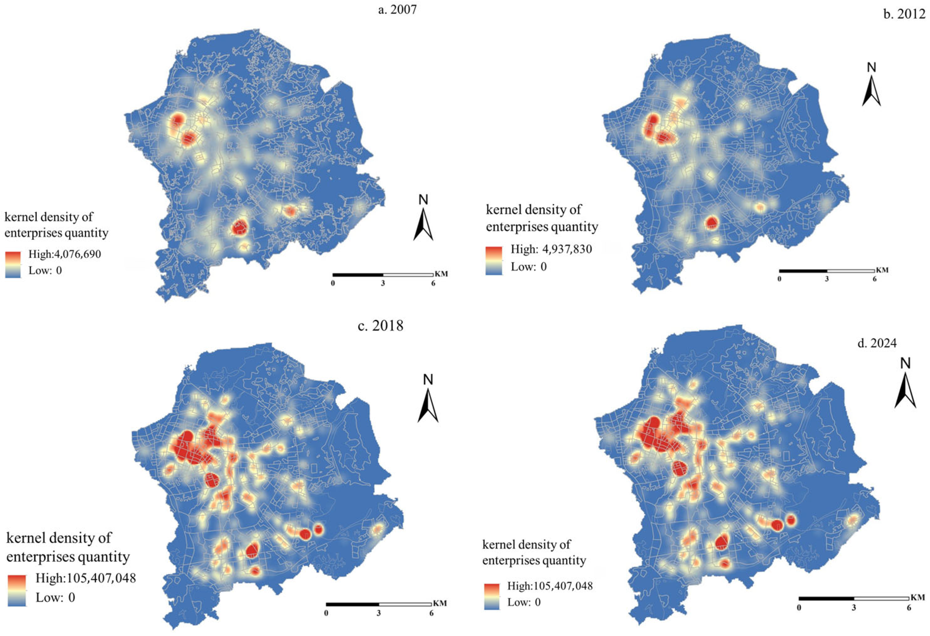
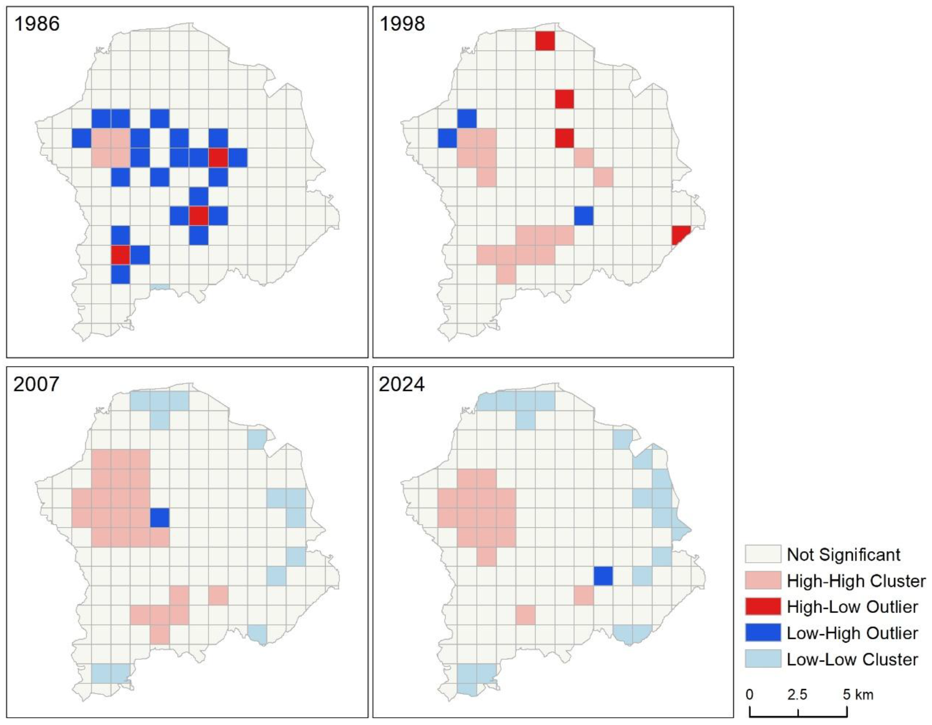
Land 15 00717 g012
Table 1. Policy Comparison between Guangming Farm and Gongming Commune (1950–1980).
DimensionGuangming Farm (State-Run Farm System)Gongming Commune (People’s Commune System)
Property Rights BasisState-owned land, used in large contiguous plotsCollective land, distributed to production teams
Production GoalsNational strategy-oriented (supplying agricultural and sideline products to Hong Kong in exchange for foreign currency)Local food self-sufficiency (fulfilling national procurement quotas)
Distribution MechanismWage system with employee welfare (medical care, education)Work-point system; grain allocated according to needs/labor contribution
Technological InputMechanization and large-scale operations (supported by national agricultural reclamation funds)Collective labor production (relying on manpower and simple tools)
Management EntityNational agricultural reclamation system (administrative enterprises)Commune administrative committee (integration of government and commune functions)
Table 2. Policy Comparison between Guangming Farm and Gongming Town (1981–2007).
Policy DimensionGuangming FarmGongming Town
1981–1992After 1992
Land PolicyState-owned land with restricted use; limited to agricultural processing extensionsCollective land within agricultural protection zones; industrial land strictly prohibitedCollective land flexibly converted for industrial use
Industrial PolicyAgriculture-oriented (supplying Hong Kong with agricultural products), supplemented by “Three-plus-one” processing tradeAgriculture-dominated economy“Five Wheels Turning” policy; locally driven investment attraction
Capital SourceGovernment appropriations and state-owned enterprise investments; participation in compensation trade (mainly Hong Kong capital)Small-scale peasant capitalForeign capital (mainly Taiwanese); village collective investment
Social StructureStable workforce with a high proportion of aging employeesPrimarily local villagersPredominantly young migrant labor force with high mobility
Institutional Reform1999: Separation of government and enterprise (social functions transferred to Guangming Subdistrict); 2002: Abolishment of the Overseas Chinese Farm system and transformation into a municipal state-owned enterprise (Guangming Group)1983: Transition from commune to district; 1986: Upgraded to town; pilot implementation of the shareholding cooperative systemPromotion of the “village-run industrial park” model
Table 3. Policy Comparison Between Emerging and Traditional Industries (2008–2025).
DimensionEmerging Industry Policies (Breaking Traditional Paths)Traditional Industry Policies (Adaptive Restructuring)
Land SupplyTargeted supply of research land; mixed-use development allowed (R&D, pilot testing, supporting facilities)“Industry-to-industry” renewal prioritized; restrictions on new industrial land
Capital SupportNational fiscal funds, venture capital, R&D subsidiesSocial capital + village collective partnerships, green technology renovation subsidies
Enterprise DevelopmentTargeted investment attraction (Global Fortune 500 R&D centers, national-level specialized and innovative enterprises), incubation from large scientific facilitiesCluster-based upgrading (e.g., mold and lingerie industrial parks), exit buffers (retraining and employment support)
Spatial GovernanceStrong government leadership (Science City Administrative Committee directly managed by the municipal government)Multi-actor negotiation (government + village collectives + developers)
Table 4. The Aggregation Index of different land use changes during 1986 to 2024.
YearFarmIndustrialScientific
198691.79NoneNone
199890.7890.8887.06
200781.3892.7488.28
202494.6293.5890.05
Table 5. Global Moran Index of the number of enterprises in Guangming District.
YearMoran IndexZ-Scorep-Value
19860.254.900
19980.366.860
20070.5310.080
20240.5510.680
Disclaimer/Publisher’s Note: The statements, opinions and data contained in all publications are solely those of the individual author(s) and contributor(s) and not of MDPI and/or the editor(s). MDPI and/or the editor(s) disclaim responsibility for any injury to people or property resulting from any ideas, methods, instructions or products referred to in the content.