1. Introduction
Land degradation has emerged as one of the most pressing environmental challenges facing human societies today [
1]. Land is a vital non-renewable resource that is increasingly being degraded by a combination of socio-economic activities—including the expansion of urban, energy, transportation, and mining infrastructures—and climatic drivers, particularly climate change [
2]. As an irreplaceable component of the ecosystem, land plays a critical role in providing a wide range of ecosystem services, and its degradation significantly undermines its capacity to deliver these benefits [
3]. These services include, but are not limited to, agricultural productivity, clean air, fresh water, climate and disturbance regulation, recreational opportunities, and fertile soil [
4]. Globally, land degradation is widespread. Approximately 40% of the Earth’s terrestrial surface is moderately degraded, while about 9% is considered highly degraded. These conditions result in a significant decline in agricultural productivity, reducing global crop yields by an estimated 13%. Furthermore, around 1.6 million hectares of land are lost to degradation each year [
5]. The broader impacts are profound, with an estimated 3 billion people being affected, either directly or indirectly, by land degradation. Economically, land degradation is responsible for an annual loss equivalent to nearly 10% of word’s gross global product [
6]. The issue is particularly severe in developing countries and in arid and semi-arid regions, where about 1.3 billion people live on degrading lands. Arid zones are especially vulnerable [
7]. One specific form of land degradation, desertification, predominantly occurs in these arid, semi-arid, and dry sub-humid environments. In such ecosystems, water availability is the primary limiting factor influencing land performance and ecosystem stability [
8].
The Middle East and North Africa (MENA) region, encompassing many arid countries, is particularly susceptible to desertification. The impacts here are profound, affecting food security, livelihoods, environmental sustainability, economic development, and even patterns of human migration [
9]. North Africa, dominated by the vast Sahara Desert, is a clear example. The region experiences extreme temperatures, sometimes exceeding 50 °C [
10], and faces additional pressures from wind and water erosion, nutrient depletion, soil salinization, and frequent sandstorms—all of which contribute to a decline in soil fertility and productivity [
11]. Tunisia, located in the Maghreb region of North Africa, is among the countries most severely affected. About 40% of Tunisia is covered by the Sahara Desert, and the remaining arable areas are increasingly threatened by degradation. TME (2022) estimated that up to 75% of the country’s land was at risk of degradation, primarily due to wind and water erosion. More recent figures indicate that this number has risen to 80% [
12], underscoring the critical nature of the issue. In response, Tunisia became a signatory of the United Nations Convention to Combat Desertification (UNCCD) in 1995 and launched its National Action Plan (NAP) in 1998. The NAP aligns with UNCCD objectives and included measures to finance integrated land management, restore productivity in affected areas, decentralize implementation, and support rural development initiatives [
13]. As part of its land restoration strategy, Tunisia has promoted several Best Management Practices (BMPs) designed to control soil erosion and enhance agricultural productivity. These include techniques such as contour ridges, recharge structures, and traditional water harvesting systems [
14]. Water harvesting techniques (WHTs) reduce runoff velocity and peak flow by increasing surface roughness and promoting water retention, thereby enhancing infiltration and limiting the detachment and transport of soil particles [
15,
16]. Moreover, the accumulation of fine sediments and organic matter upstream of these structures leads to improvements in soil texture, increases in soil water-holding capacity, and enhanced soil fertility [
17]. The resulting prolongation of soil moisture availability supports vegetation establishment and ground cover development, which in turn contributes to further reductions in erosion risk and land degradation processes [
18]. Specifically, systems like Meskat, Jessour, and check dams are widely used in the southern regions and serve dual functions, as both BMPs and WHTs, aimed at efficiently capturing and managing scarce rainfall. Studies have highlighted their potential: Jessour systems could increase available water resources by a factor of 2.5 [
19], while cisterns can meet a household’s domestic water need [
20]. However, despite their extensive implementation, comprehensive and systematic evaluations of their effectiveness in mitigating land degradation are still limited. To address this, various models have been developed to assess land degradation. One widely used approach is the MEDALUS framework [
21,
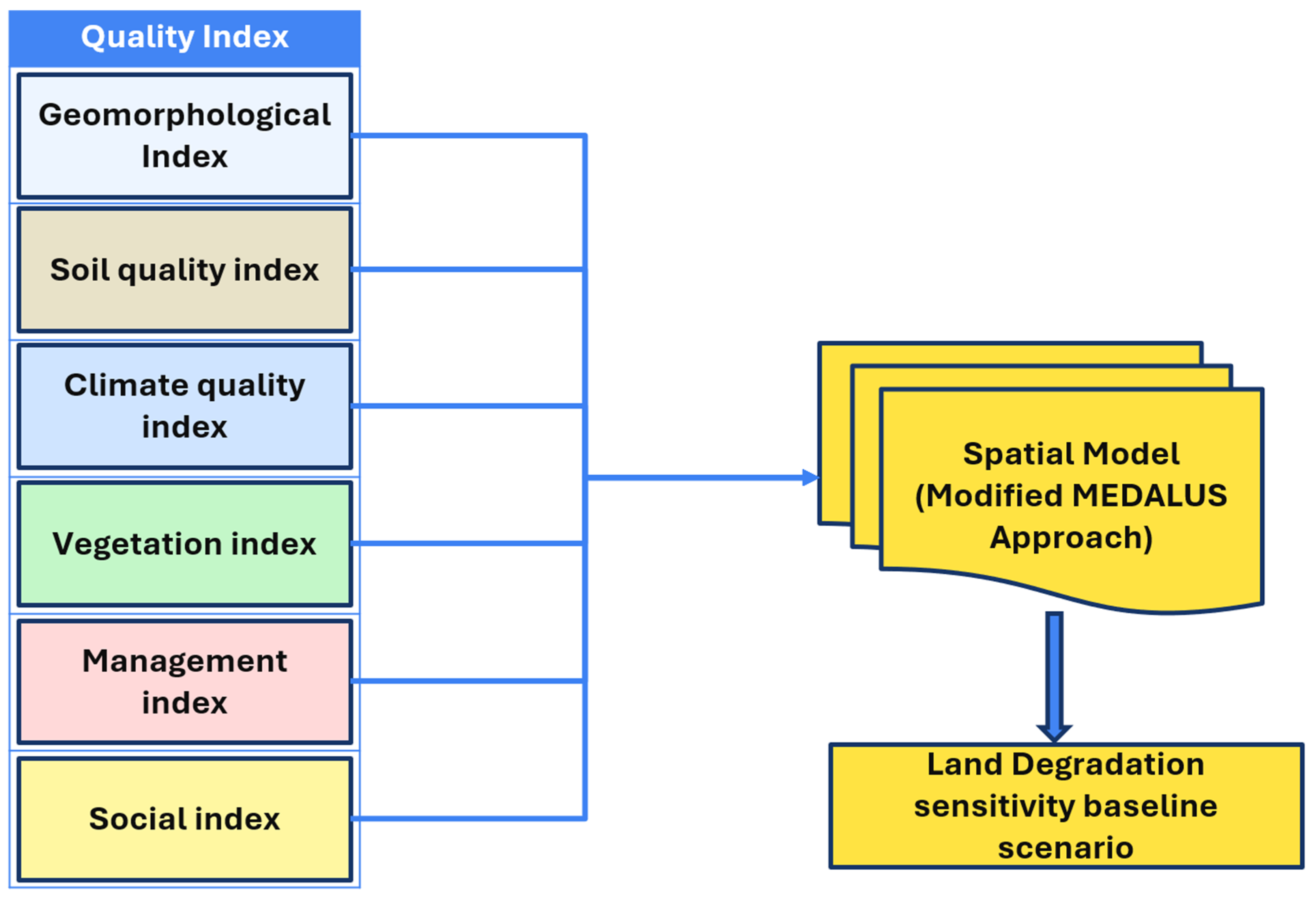
22], which integrates four primary factors—climate, soil, vegetation, and land management—to classify and visualize environmentally sensitive areas [
8]. While several studies have used this model in Tunisia [
23,
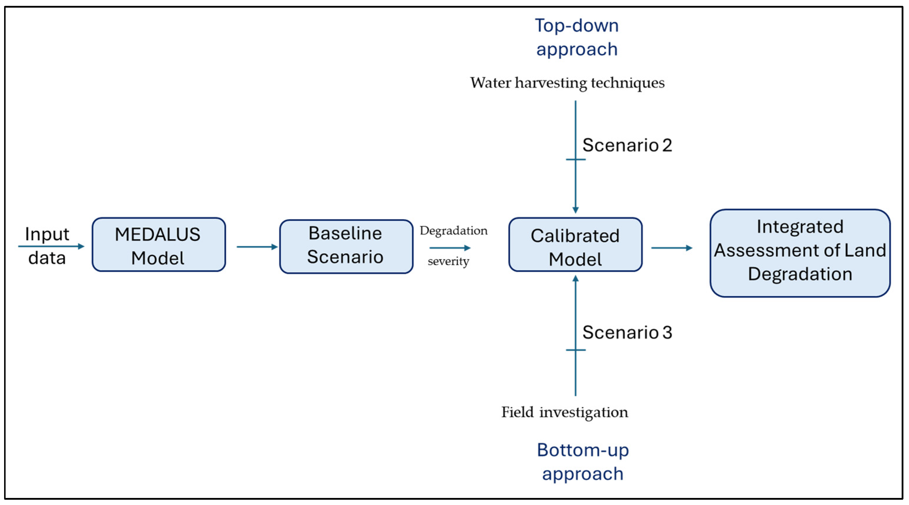
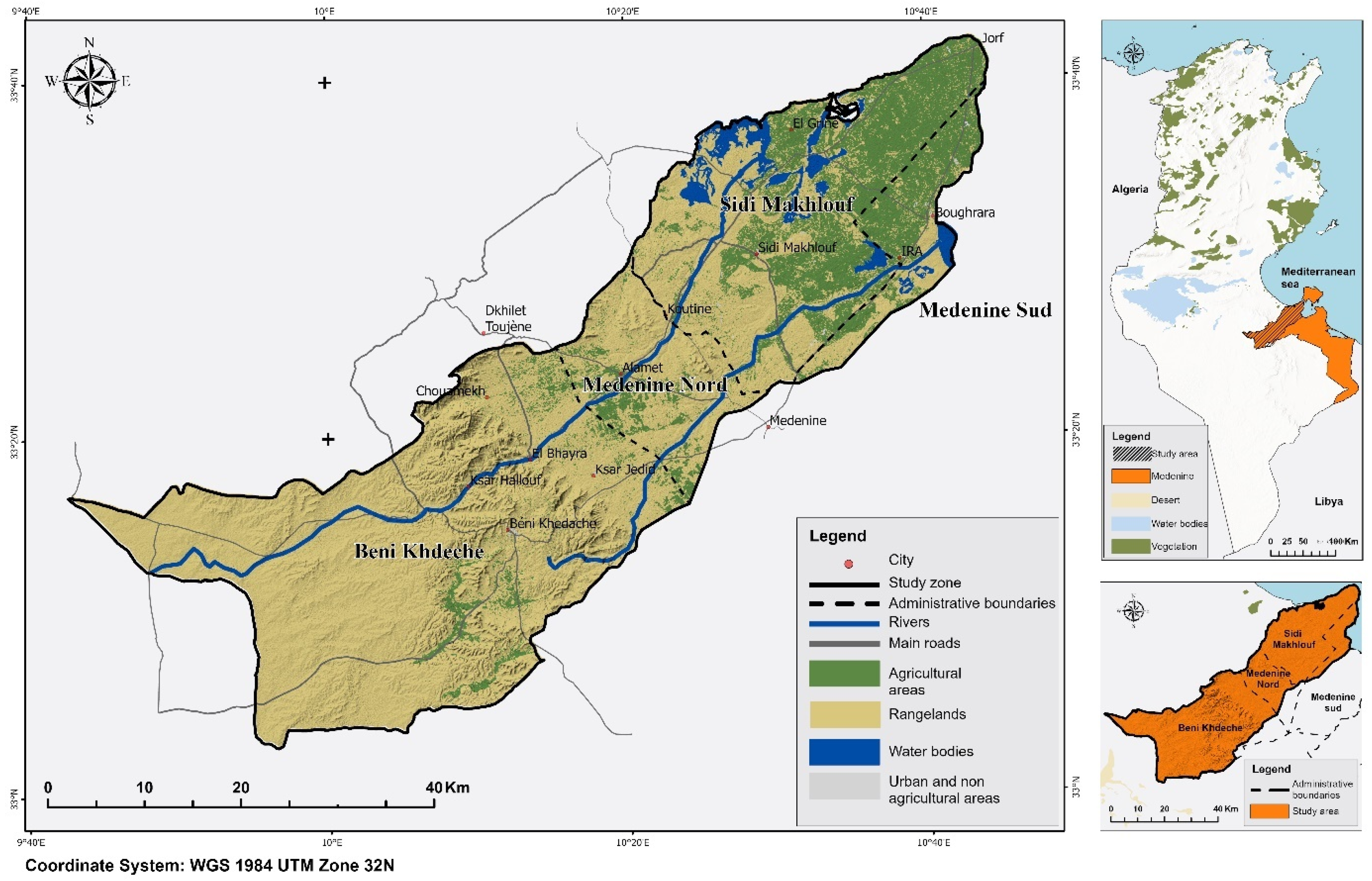
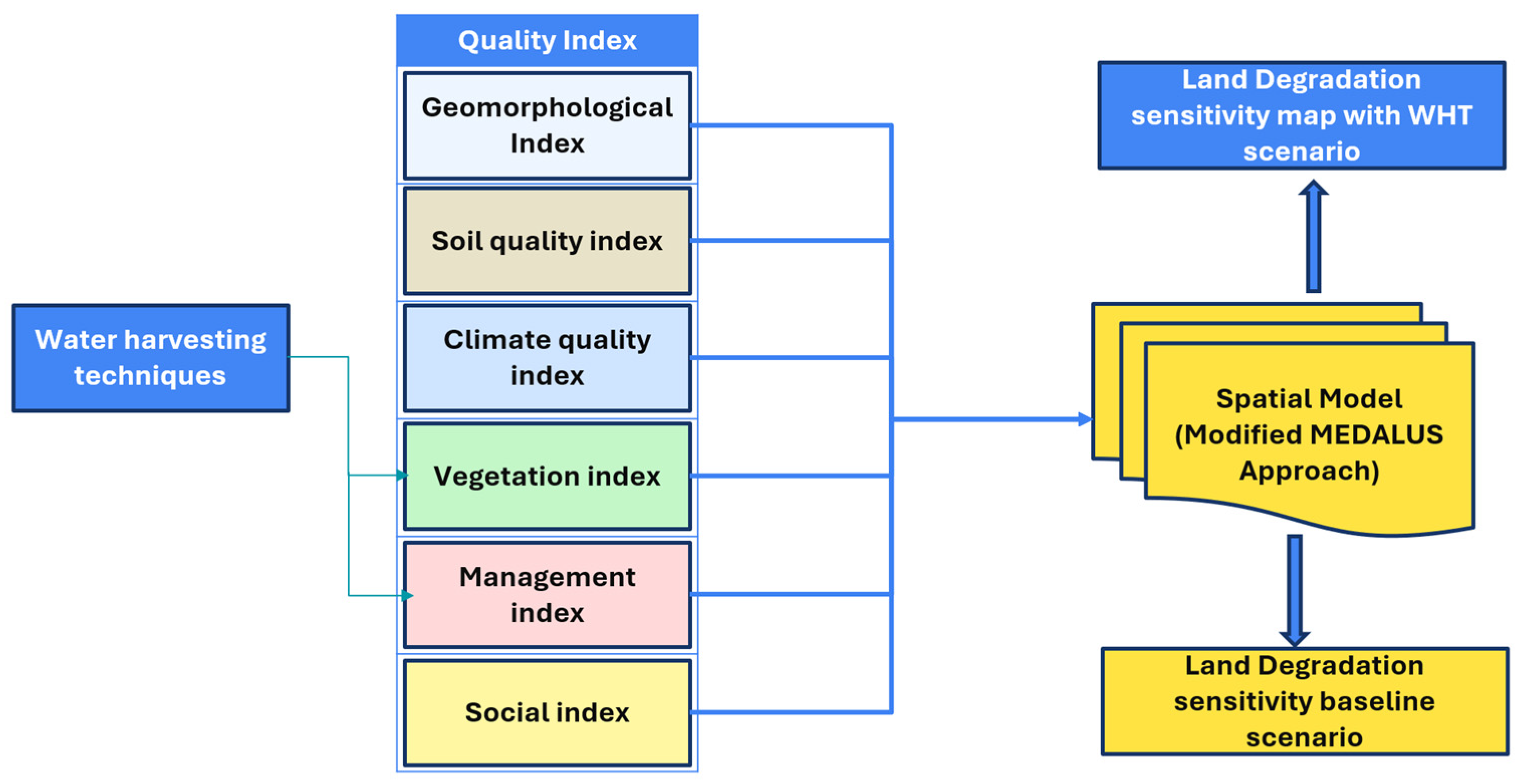
24], none have explicitly evaluated environmentally sensitive areas under different land management scenarios that incorporate the presence of BMPs. This study seeks to fill that gap by assessing the sensitivity to desertification in the Jeffara region of Southern Tunisia. The MEDALUS framework has been widely used to assess land sensitivity to degradation; most existing studies rely on static biophysical indicators and give limited consideration to land management practices as dynamic drivers of change. In particular, the role of water harvesting techniques (WHTs) in modifying land sensitivity classes and mitigating degradation processes remains insufficiently understood, especially in highly arid regions subject to strong climatic stress and human pressures. This study addresses this gap by explicitly integrating WHTs into the MEDALUS-based assessment in the Jeffara region of southern Tunisia. By doing so, the research moves beyond descriptive sensitivity mapping and provides new insights into how water harvesting practices can be incorporated into land degradation assessments to better inform sustainable land management in arid environments. It evaluates the impact of two key water harvesting techniques—Tabias and Jessour. This study aims to assess land degradation sensitivity in the Jeffara region of southern Tunisia, with a focus on desertification in arid environments. It explicitly integrates water harvesting techniques (Tabias and Jessour) into the MEDALUS framework to evaluate their role in reducing land sensitivity and mitigating degradation through Geographic Information System (GIS)-based analysis over the period 2000–2022.
4. Discussion
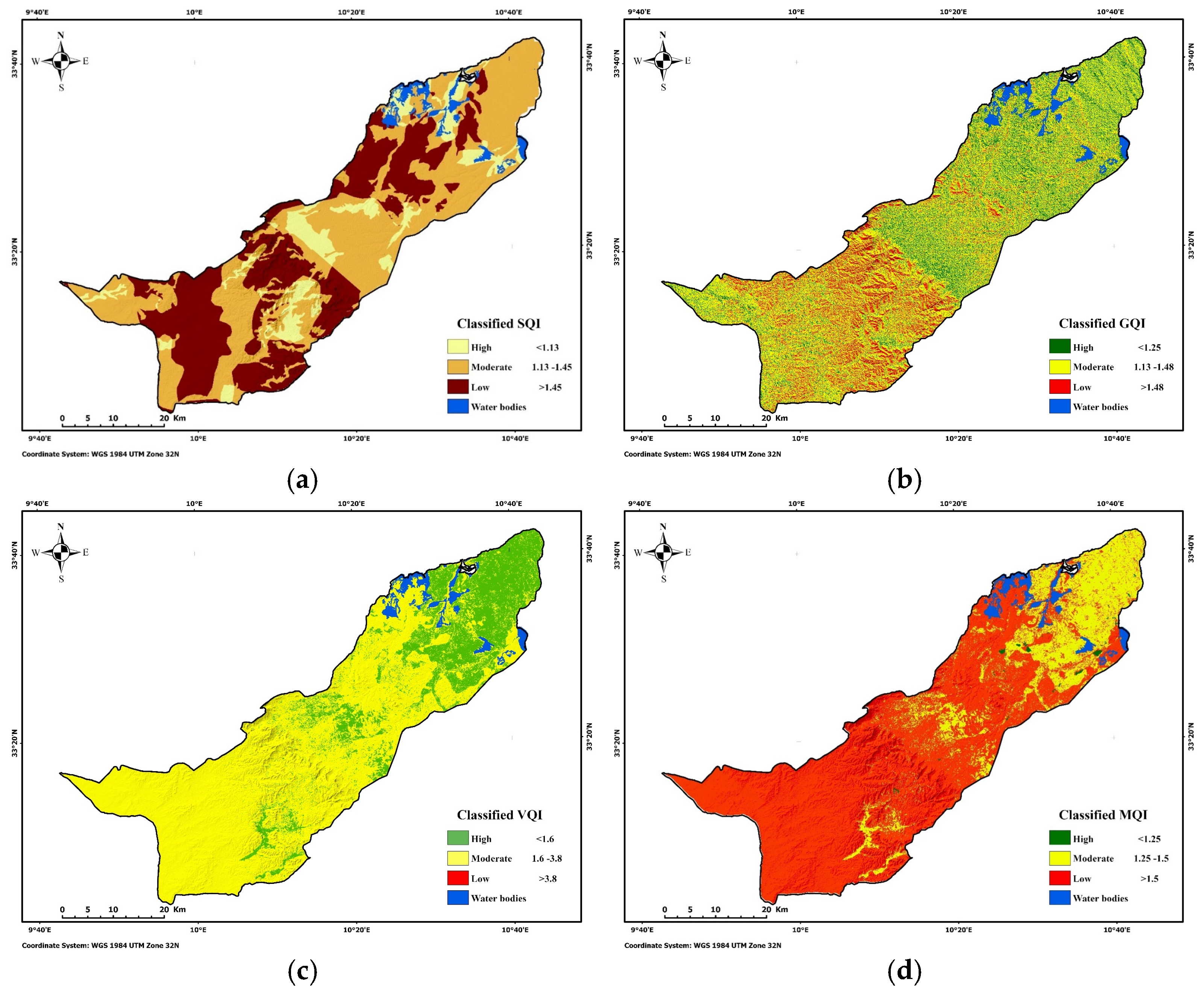
The moderate to high overall Vegetation Index, despite low vegetation cover, is largely explained by the sparse vegetation in rangelands and the significant spacing between vegetation in olive orchards, which reduces fire risk. Additionally, crops cultivated, such as olives, are drought-resistant and well-adapted to the local climate, affecting positively the former index.
The high level of land management is primarily linked to two sub-indexes: agricultural intensity and policy enforcement. Olive-based agricultural systems received medium scores for both indexes, reflecting average management practices and policy application. In contrast, the already degraded condition of rangelands, combined with limited policy enforcement, contributed to higher degradation levels in those areas.
Population density and the old age index were the most influential sub-indexes, contributing to moderate and low scores in the central and western parts of the region for the socio-economic index. While these values remained high around the Mountains area, the population growth index was generally low across the region and had a minimal impact on increasing the overall EQI.
The dominance of low climatic quality across the study area is consistent with previous MEDALUS-based assessments conducted in semi-arid and arid environments of Tunisia and the southern Mediterranean basin [
23]. In such contexts, low precipitation combined with high Potential Evapotranspiration has been widely identified as the primary driver of climate-related land degradation sensitivity [
23,
31]. However, unlike studies conducted at broader spatial scales in central Tunisia, where the Climate Quality Index (CQI) exhibited marked spatial variability [
23,
24], the CQI in the present study remained constant across the entire area. This lack of variability can be attributed both to the relatively limited spatial extent of the study area and to the scale at which the MEDALUS framework was originally conceived, namely for regional to national-scale assessments rather than local applications [
21,
22].
Soil quality emerged as a major determinant of land degradation sensitivity, with more than 85% of the study area classified as having moderate to low soil quality. This finding is strongly consistent with previous studies in Tunisia, which highlighted the vulnerability of soils developed on fragile parent materials, shallow profiles, and calcareous formations under semi-arid climatic conditions [
23,
31]. Several studies have emphasized that parent material and soil depth often exert a stronger control on soil degradation sensitivity than texture alone, particularly in Mediterranean drylands [
24,
31]. The spatial coincidence between low soil quality, mountainous zones, desert margins, and mining sites observed in this study further supports earlier findings that geomorphology and anthropogenic disturbances jointly accelerate soil degradation processes [
8,
23].
In line with earlier studies, olive-based agroecosystems showed higher vegetation quality compared to rangelands, reflecting the adaptive capacity of perennial crops to arid conditions and their stabilizing role in limiting erosion and land degradation [
24,
32]. Conversely, rangelands consistently appeared as more vulnerable systems due to sparse vegetation cover and continuous grazing pressure, a pattern widely documented in Tunisian steppe environments [
8,
23].
The Socio-Economic Quality Index indicated relatively high values over much of the study area, suggesting moderate overall anthropogenic pressure. However, as also reported in earlier MEDALUS-based studies, the calculation of socio-economic indicators at the municipal level tends to reduce spatial variability and may mask localized degradation hotspots which can explain why previously mentioned studies did not use a socio-economic indicator in their model.
Overall, the strong agreement between the present results and previous MEDALUS-based studies supports the robustness of the framework under Tunisian semi-arid conditions [
21,
23,
31]. At the same time, the limited variability observed for certain indices highlights the need for methodological adaptations and the integration of management-oriented indicators, particularly when the objective is to assess land degradation sensitivity at local scales and under different land management scenarios [
22,
24].
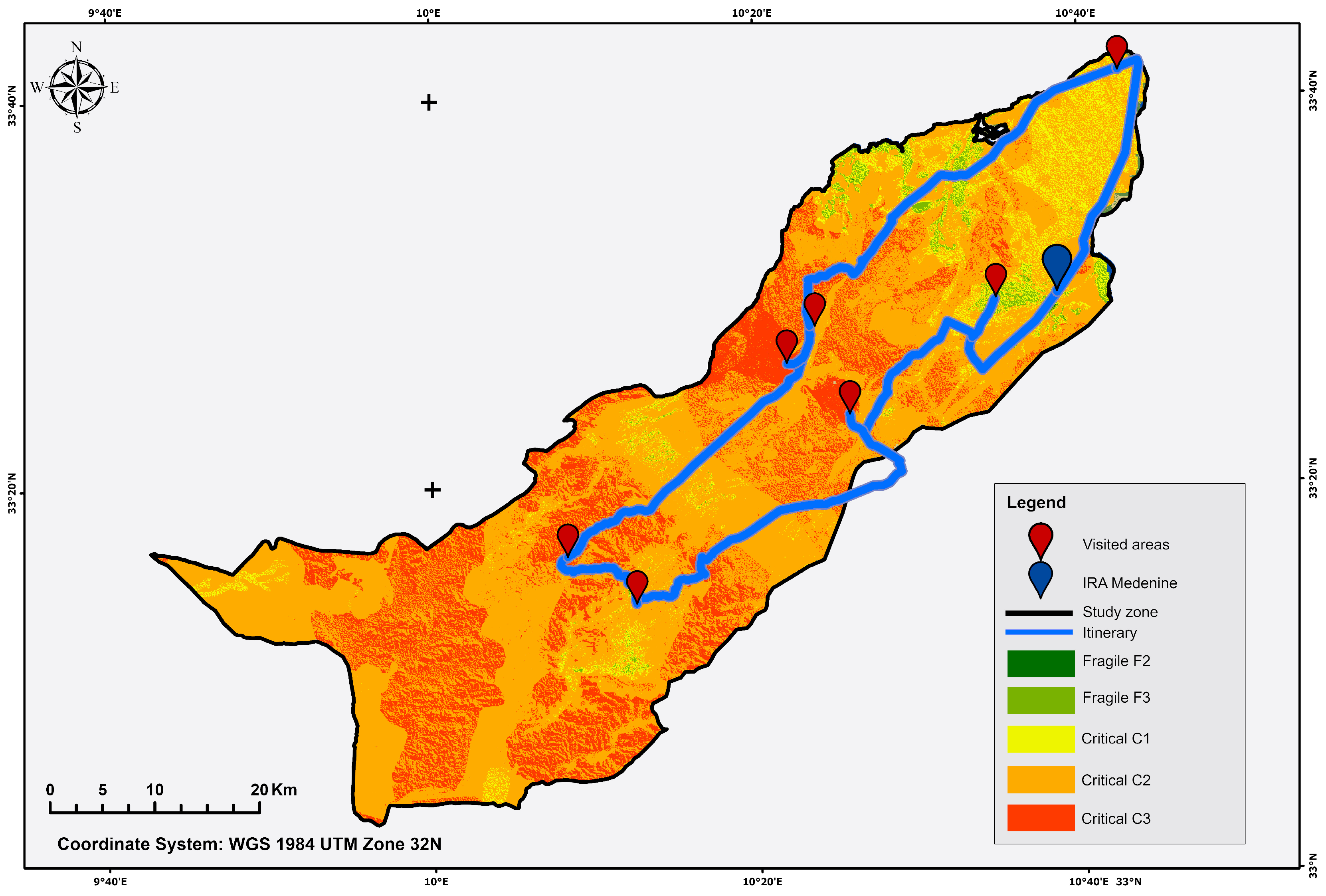
The derived Land Degradation Sensitivity Index (LDSI) aligned with field observations and survey data, particularly in identifying severely degraded zones west of the Mountains area, where sand encroachment and degraded rangelands dominate. However, discrepancies arose in the northern area of the study case, where visible land degradation was not emphasized in survey responses. This divergence likely stems from the relatively localized impact of bare lands and extraction sites compared to the widespread degradation in western rangelands, which directly threatens livelihoods and thus may affect community perceptions. Migration emerged as both a driver and consequence of degradation as sustained rural outmigration since the 1990s has reduced labor and accelerated land abandonment in these areas [
34]. This result is comparable to, and in some cases exceeds, findings reported in other Tunisian case studies, where fragile and critical classes together typically accounted for more than 80–90% of the total area [
23,
35]. The concentration of the highest sensitivity class (C3) in mountainous areas, desert zones, mining sites, and bare lands confirms the cumulative effect of adverse climatic conditions, fragile soils, steep slopes, and inadequate land management, as previously highlighted in MEDALUS applications across North Africa [
8,
21,
22]. In contrast, olive orchards were predominantly associated with the least critical class (C1), reinforcing earlier evidence that perennial cropping systems can mitigate land degradation sensitivity when compared to extensively grazed rangelands.
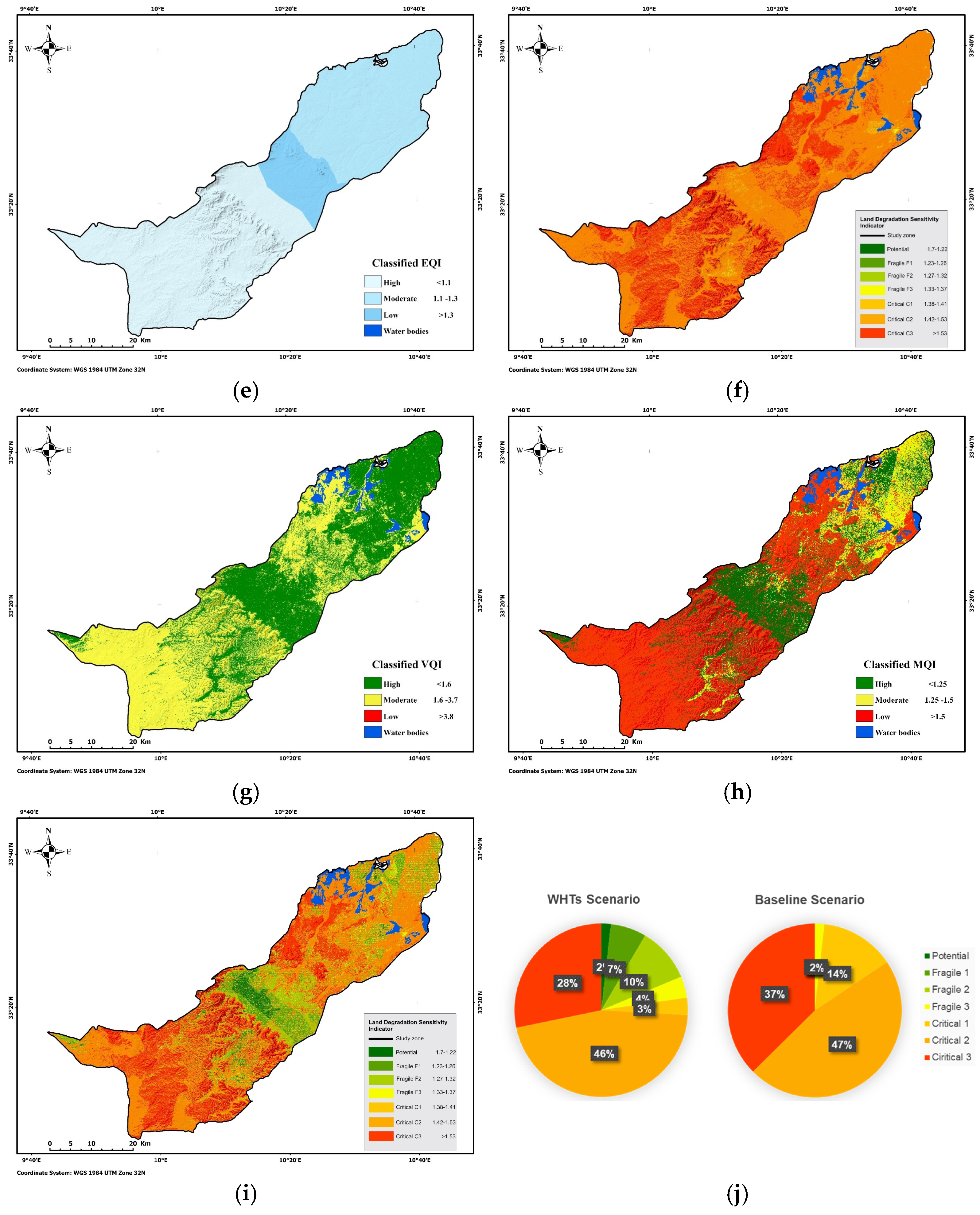
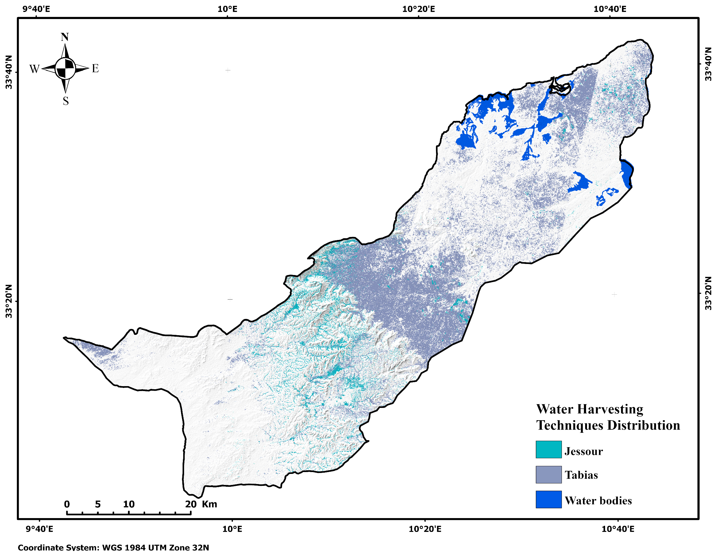
Spatially, the increase followed the same pattern of WHTs distribution (
Figure 7i). The areas classified as potential, F1, F2 colored with different shades of green, and F3 colored with yellow were located in the area containing Jessour, Tabias, and olive orchards. These areas are located within the valleys and foothills of the Mountains area. These areas, in the baseline scenario, were mostly in the Critical class. The Critical 3 class mostly saw less changes; the decrease was only 9.15%. The areas that stayed severely critical (C3) were mostly located around the Mountains area, desert, mining sites, and bare lands.
The most pronounced improvements were observed in areas containing maintained olive groves, associated with Tabias and Jessour where the shift from high to moderate sensitivity accounted for a substantial portion of the change. In contrast, areas dominated sharing similar geographical features with less to no vegetation did not show signs of improvement, reflecting the influence of maintenance and local functionality on WHT performance. Crete shows a similar trend: applying sustainable land management measures reduced highly sensitive areas from 28% to 23%, with corresponding increases in moderate-sensitivity areas [
22]. While the magnitude of improvement in our study is slightly higher, particularly in olive groves, the pattern aligns with expectations under sustainable management scenarios. Differences in other WHT types (Tabias or Jessour) likely stem from local biophysical conditions, structure maintenance, and socio-economic constraints.
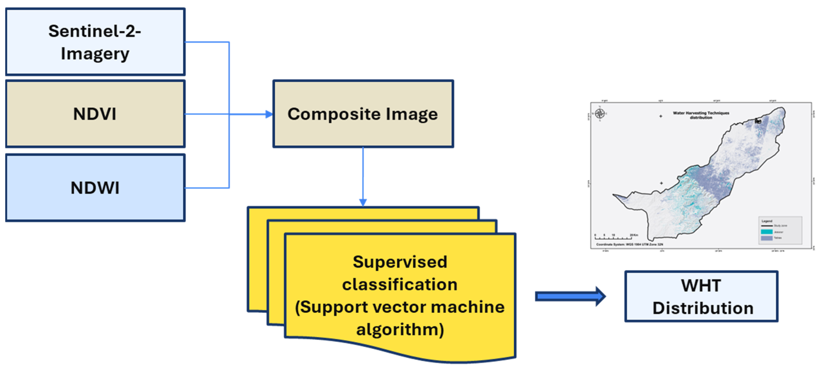
These improvements, however, assume idealized conditions of fully functional and maintained structures. In reality, non-maintained Jessour or abandoned Tabias are common and may underperform, suggesting that the modeled results represent optimistic scenarios. Furthermore, semi-automatic WHTs mapping using NDVI, NDWI, and DEM risked overestimating their spatial distribution, as natural features with similar spectral signatures can be misclassified. Therefore, locals’ input is irreplaceable to better map these management practices. Nevertheless, stakeholder perceptions illuminated the socio-economic barriers to WHTs adoption. While farmers were aware and recognized their benefits for water retention and erosion control, financial constraints and labor-intensive maintenance hindered widespread implementation. This paradox highlights the need for targeted subsidies and community-led stewardship programs to sustain WHTs efficacy. In the literature, using MEADLUS methodology with different scenarios is common, for instance [
22], integrated future climate change scenarios and soil management scenarios, indicating that implementing sustainable land management practices could slightly mitigate the land degradation process for critical areas. Spatially, the distribution mostly stayed the same expect for highly critical areas. The concentration of C3 increased in the area west of the Mountains area range. This area was initially prioritized, as stakeholders consistently indicated that it was the most severely degraded within the study site.
At the community level, land degradation was associated with significant socio-economic impacts, including rural-to-urban migration, loss of biodiversity and reduced agricultural income, and poverty levels.
Migration emerged as the dominant socio-economic impact and also as the dominant driver (53%), followed by population growth and low education levels (20%) each. Only 7% of the respondents reported the old age ratio as a socio-economic cause.
Although various water harvesting techniques (WHTs) such as Jessour, Tabias, and cisterns were widely recognized, only 60% of respondents considered farmers to be well-informed about these techniques. The main barriers hindering WHTS implementation were primarily the high installation costs, labor requirements, and limited government support, while limited revenue generation and lack of knowledge were also noted. Nonetheless, WHTS were largely perceived as beneficial, with respondents highlighting improved water retention, enhanced crop productivity, and reduced erosion as the most significant opportunities.
A few limitations arose in this study. Spatial resolution varied among the input layers (30 m to 500 m), and resampling was applied to harmonize them, which may introduce numerical bias. Soil data were obtained from publicly available global maps (ISRIC, 2020), which may not fully capture local variability. Climate data, including precipitation and aridity index, have relatively coarse resolution (~50 km), which could affect the Climate Quality Index at fine scales. Vegetation data were derived from Sentinel-2 Level-2A composites; cloud-contaminated scenes were excluded, and NDVI thresholds followed the prior literature, which may introduce uncertainty in classification. However, the impact is minimal as both the vegetation and climatic responses consistently remained within the highest sensitivity levels. Validation relied on field observation points only, as no historical maps or previous studies for the same study area were available for direct comparison. To improve the spatial accuracy of these systems, further work is required to refine the WHTs in the region, which will support future case studies and analysis.
5. Conclusions and Recommendations
This study assessed land degradation sensitivity in the Jeffara region of Southern Tunisia and evaluated the role of water harvesting techniques (WHTs) as mitigation strategies. By integrating the MEDALUS framework with GIS-based spatial analysis and stakeholder-driven insights, this research revealed that over 99% of the study area falls under critical sensitivity classes (C1–C3), driven by extreme aridity, sparse vegetation, soil erosion, and anthropogenic pressures such as rural migration. The Mountains area, desert margins, and mining zones exhibited the highest degradation severity (C3), while olive orchards demonstrated marginally lower sensitivity due to drought-resistant vegetation and less fire risk.
The simulation of WHTs implementation, specifically Jessour and Tabias, highlighted their potential to reduce critical degradation zones, primarily in valleys and foothills. These techniques improved vegetation quality and management. The simulation of WHTs implementation highlighted their potential to reduce highly sensitive zones, primarily in valleys and foothills. Quantitatively, the highly sensitive area decreased from 831.41 km2 (21.76%) in the baseline scenario to 481.52 km2 (37.65%) after WHTs application, while moderately sensitive areas increased from 1376.73 km2 (78.24%) to 1731.26 km2 (62.35%). Improvements were most pronounced in areas containing maintained olive groves, where Tabias and Jessour areas showed significant effects.
However, stakeholder surveys underscored systemic barriers to WHTs adoption, including high installation costs and labor-intensive maintenance, which hinder their scalability despite recognized benefits in erosion control and yield stability.
Further, scaling the MEDALUS with decision-making-driven methodologies to other arid regions could standardize degradation sensitivity assessments while accommodating local socio-economic contexts. Limitations of this study include differences in spatial accuracy among datasets and reliance on older soil maps. Therefore, future research should refine WHTs mapping through high-resolution datasets and machine learning to reduce classification inaccuracies. Longitudinal studies on migration’s role in land abandonment and degradation feedback loops are also critical to inform holistic policy frameworks.
Ultimately, mitigating land degradation sensitivity in Jeffara and similar regions demands synergies between traditional practices, scientific innovation, and participatory governance. By aligning technical solutions with community needs and institutional capacities, Tunisia can advance sustainable land management while safeguarding livelihoods in its vulnerable arid ecosystems.




 ,
,