


Abstract
Urban rivers are critical ecological and cultural assets facing accelerating biodiversity loss. This study examines the integrated redevelopment of the Jadro River spring in Solin, Croatia, where a protected ichthyological reserve intersects layered heritage and urban edges to enhance conservation and public value. Using a single-case study design that combines archival project documentation, participant observation by the architect–authors, and a post-occupancy review three years after completion, the analysis synthesizes ecological, social, and design evidence across planning, delivery, and operation phases. The project delivered phased visitor and interpretation centers, accessible paths and bridges, habitat-compatible materials, and formalized access management that relocated parking from riverbanks, reduced episodic pollution sources, and prioritized inclusive, low-impact use. Governance and programming established a municipal management plan, curriculum-ready interpretation, and carrying capacity monitoring, transforming an underused picnic area into an educational, recreational, and conservation-oriented public landscape while safeguarding sensitive habitats. A transferable design protocol emerged, aligning blue green infrastructure, heritage conservation, adaptive reuse, and social–ecological system (SES)-informed placemaking to protect the endemic soft-mouth trout and strengthen a sense of place and community stewardship. The case supports SES-based riverpark renewal in which conservative interventions within protected cores are coupled with consolidated services on resilient ground, offering a replicable framework for ecologically constrained urban headwaters.
1. Introduction
Rivers flowing through urban areas are increasingly recognized as essential components of the broader ecological network, providing critical habitats and supporting a diverse array of species. Biodiversity is fundamental to human well-being. As it is stated in the United Nations’ Convention on Biological Diversity, an average of around 25% of the species in assessed animal and plant groups are threatened, suggesting that around 1 million species already face extinction, many within decades, unless action is taken to reduce the intensity of drivers of biodiversity loss [1] (p. 4). This is particularly addressed to freshwater habitats because, although they cover less than 1% of the Earth’s surface, they are home to approximately one-third of vertebrate animals and 10% of all species. Freshwater ecosystems are highly stressed due to passing through agricultural, industrial, or urban infrastructure [2] (p. 2). According to a major International Union for Conservation of Nature (IUCN)-backed assessment published in January 2025, 24% of the freshwater animal species evaluated are threatened with extinction. This represents nearly 1 in 4 of the 23,496 species of fish, decapods (crabs, crayfish, and shrimp), and odonatans (dragonflies and damselflies) that were assessed [3].
Beyond their ecological value, these river landscapes contribute significantly to the well-being of city dwellers, offering spaces for recreation, enhancing the quality of life in urban environments, and even holding cultural and spiritual significance. The redevelopment of such areas presents a crucial opportunity to address ecological degradation that often occurs due to urbanization.
Many authors in the last decades have addressed the shift in paradigm toward understanding and managing riverscapes as complex social–ecological systems (SESs). Sargolini et al. emphasized integrating urban design with socio-ecological networks to enhance both human health and biodiversity, as demonstrated in frameworks linking green infrastructure to preventive health models. This holistic approach aligns urban planning with One Health principles, promoting resilient cities through blue–green corridors like river springs [4]. Lopez et al. defined a social–ecological system as a highly connected organization of biophysical and social actors that interact across multiple scales, share resources, and adapt to the actors’ changes [5] (p. 197). Their case study of the San Marcos River in Texas (USA) contributed to the integration of ecosystem services, environmental values, and human–environment interactions into a more holistic approach to environmental valuation. This integrated approach not only serves environmental objectives but also offers social and economic advantages, contributing to community well-being through enhanced recreational spaces and potentially reducing the costs associated with traditional engineered infrastructure.
Dunham et al. stated that an SES perspective appeals to what people who live in, work on, recreate in, or conduct research on rivers already know: that humans strongly influence and are influenced by riverscapes [6] (p. 2). Perry et al. addressed resilient river SESs as a new paradigm to meet global conservation targets to reverse freshwater biodiversity loss [2]. Additionally, Gottwald et al. proposed sense of place as an overarching theory for cultural ecosystem services, especially in river landscapes [7] (p. 633). The concept of sense of place refers to the emotional bonds, strongly felt values, and awareness of the cultural, historical, and spatial context within which meanings, values, and social connections are formed by people in specific locations. For most people, sense of place refers to the rich and varied meanings of place and emphasizes people’s tendency to form strong emotional bonds with places. It is worth noting that although the importance of recognizing local meanings is emphasized, these should not be limited to residents’ sense of place. Many tourists and regular visitors have a strong attachment to places as well [8].
Considering that rivers are complex social–ecological systems, where human activities and natural processes are intricately linked, an approach to the management of riverscapes that acknowledges the intricate relationship between natural and human systems is therefore essential for achieving sustainable and beneficial outcomes. Consequently, effective river landscape redevelopment necessitates a comprehensive approach that moves beyond purely functional or aesthetic considerations. It requires embracing the ecological integrity of the river system, respecting and integrating cultural heritage elements, and addressing the diverse needs of the surrounding communities. Recognizing both the tangible, physical attributes of these landscapes and their intangible values, such as cultural associations and sense of place, is crucial for successful redevelopment.
Theoretical frameworks like SESs and sense of place provide foundational principles for river redevelopment, yet their practical application requires translating abstract concepts into site-specific interventions that balance ecology, culture, and community needs. This paper analyses the key aspects of the redevelopment project in the area of the spring of the Jadro River in Solin, Croatia. The spring of the Jadro River has been a central feature of the region for millennia. It serves as a vital component of Solin’s blue–green infrastructure, playing a crucial ecological role within the urban environment [9,10]. Furthermore, its significance extends beyond the local context, as it has been and still is a primary source of drinking water for the broader urban agglomeration of Split, the second largest city in Croatia [11]. The ancient water intakes at the spring of the Jadro River were crucial for the water supply of Salona and Diocletian’s Palace during the Roman period. Archaeological investigations have revealed the developmental phases of these intakes and the characteristics of the aqueducts that supplied these important Roman settlements [12]. This enduring connection between the river and human settlements underscores its profound and lasting importance; thus, the analyzed project represents a significant case study in integrated urban riverscape redevelopment.
The project’s complex context, which includes a protected ichthyological reserve, notable archaeological landmarks, and underused spaces with possible environmental hazards, makes it particularly relevant for examining ongoing practices in this field.
The purpose of this analysis is to evaluate the conceptual settings, the process of designing the project, and the resulting impacts of the architectural and urban design interventions implemented at the Jadro River spring, providing valuable insights into the principles of successful redevelopment of riverscape parts.
2. The Jadro River Spring Redevelopment: A Case Study in Integrated Design
2.1. Study Area
The Jadro River is located in the central Dalmatia region, Croatia. It rises at the foot of the mountain Mosor (33 m absolute height) and flows through the town of Solin into the Adriatic Sea (Kaštela Bay). Solin, built on the site of ancient Salona—the capital of the Roman province of Dalmatia—holds great historical significance as a center of early Christianity and later as one of the most important strongholds of the early medieval Croatian state, where the Croats settled after the fall of Salona [13]. The Jadro River was crucial to Solin’s historical development, as its spring provided fresh water, enabling the emergence, growth, and continuity of life from ancient Salona to medieval Solin and beyond [9,10].
Although the Jadro River is only about 4.5 km long, it plays an important role in both the natural and urban environment. Consequently, many projects have examined and explored the area from different perspectives and with diverse goals. In total, five projects were funded in the last decade from different European Union (EU) funding sources; some of them deal with the whole riverbed, some with particular areas of the river, and some with specific aspects of the river.
The flagship project named “Jadro–Spring of Life” was conducted from 2016 to 2022 and aimed to unify the area around the special reserve of the Jadro spring into a unique visitor area for the purpose of preserving bio- and geodiversity [14,15]. This project valorizes the spring of the Jadro through the development of visitor infrastructure, which increases educational capacity and also establishes better management and protection of natural heritage. Special attention was paid to the infrastructure that contributes to the protection of the ichthyological reserve and the endemic species of soft-mouth trout [16]. The project contributed to the education of the population and visitors, which will ensure the long-term ecological sustainability of the excursion site. The main activities included the construction and outfitting of visitor and interpretive center buildings, defining pedestrian areas, and developing a network of educational trails. Special focus was on protecting the endemic soft-mouth trout called Solinka and the creation of educational programs for various age groups, development of interpretation tools (brochures, mobile apps), and workshops to raise public awareness about the importance of the Jadro ecosystem. It was funded by the European Regional Development Fund, with a total value of more than EUR 3,200,000.00. The project holder was the Public Institution for Management of Protected Areas in the County of Split and Dalmatia—“Sea and Karst”, and the partners were the City of Solin and the Solin Tourist Board [17]. Prior to this, an idea of arranging an interactive, participatory park and garden on the plateau of the former marlstone quarry called “Mayday! Majdan! Mayday!—Ex Marlstone Quarry as a Community Space” was submitted in 2014 at the “Idea Camp” organized by the European Cultural Foundation, whose theme was activating the community in redefining and shaping public spaces [18,19]. At the beginning of 2017, the developed project was included in the integrated application for the project “Jadro-Spring of Life”. So, as part of the aforementioned project, the redevelopment of the marl quarry into a park was executed, and the area of the spring of the Jadro River was designed and built as a continuation of the process. A detailed analysis of this process will be given in further sections of this article, as a topic of case study research.
The cross-border project named “RiTour–River Tourism” focused on enhancing river heritage tourism around the natural assets set across Croatia, Bosnia and Herzegovina, and Montenegro, which included the Jadro River. The project was conducted from 2017 to 2019, and the key activities for the Jadro River area involved developing excursion infrastructure, restoring Diocletian’s Aqueduct, and preserving natural habitats. The project was part of the Interreg IPA program funded by the EU, led by Public Institution RERA S.D. for coordination and development of the Split–Dalmatia County, with partners the City of Solin (Croatia), the Public Institution for the Management of Protected Areas in the County of Split and Dalmatia “Sea and Karst” (Croatia), the Tourist board of the Herzegovina–Neretva Canton (Bosnia and Herzegovina), the City of Mostar (Bosnia and Herzegovina), and the Tourist organization of Podgorica (Montenegro) [20].
An interregional project called “CHANGE WE CARE—Climate cHallenges on coAstal and traNsitional chanGing arEas: WEeaving a Cross-Adriatic REsponse”, conducted from 2019 to 2021, aimed to create a connection between all stakeholders and improve the capacities of local and regional authorities in identifying appropriate climate change adaptation measures in coastal areas. The lead partner of the project was the Institute of Marine Sciences of Venezia, Italy, and a total of 11 partners from Italy and Croatia participated in the project. The main outcome of the project was to deliver integrated, ecosystem-based, and shared planning options for different problems related to climate change (CC), together with adaptation measures for vulnerable areas, to decision makers and coastal communities who may best benefit from it. Within this project, the CLIMATE CHANGE ADAPTATION PLAN FOR THE JADRO RIVER AREA was developed by the Faculty of Civil Engineering, Architecture and Geodesy in Split, Croatia [21].
Currently, for the entire course of the river, there is an ongoing project named “Improve River LIFE”. The main objective of the project is to improve the level of conservation of the soft-mouth trout (Salmo obtusirostris), an endangered and endemic species that is found only in a few rivers of the Adriatic basin in Croatia, Bosnia and Herzegovina, and Montenegro. This goal is to be achieved by improving the habitat conditions in the rivers Vrljika and Jadro, which represent the only remaining soft-mouth habitat in Croatia. The project thus lays the foundation for improving river continuity at the national level and contributes to achieving the EU Biodiversity Strategy’s goal of converting at least 25,000 km of rivers into free-flowing rivers by 2030, i.e., restoring them to their natural state by removing obstacles and restoring floodplains. The project is funded through the LIFE program of the EU. The national co-financing of the project is provided by the Environmental Protection and Energy Efficiency Fund and partner institutions [22].
All aforementioned projects emphasize the importance of the Jadro River for its surroundings. The ongoing research potential is reflected in the study from 2020 named “Application of Open Source Electronics for Measurements of Surface Water Properties in an Estuary: A Case Study of River Jadro, Croatia,” which demonstrates the use of an affordable, open-source floating probe for measuring position, temperature, and electrical conductivity during repeated field campaigns at the Jadro estuary. The results, used to model mean flow velocity and salinity, highlight the potential for low-cost monitoring technologies to support integrated water management and habitat restoration along the Jadro River [23]. More recently, a new study named “Exceeding Turbidity versus Karst Spring Discharge during Single Rainfall Events: The Case of the Jadro Spring” analyzed the relationship between karst spring discharge and turbidity during periods where the turbidity exceeds the permitted value in the area of the karst catchment of the Jadro spring in Croatia [24]. Both of these studies were part of the research conducted by researchers at the Faculty of Civil Engineering, Architecture and Geodesy in Split, Croatia (FCEAG in Split), sharpening the authors’ shared, same-faculty perspective on the river’s significance and the selected site.
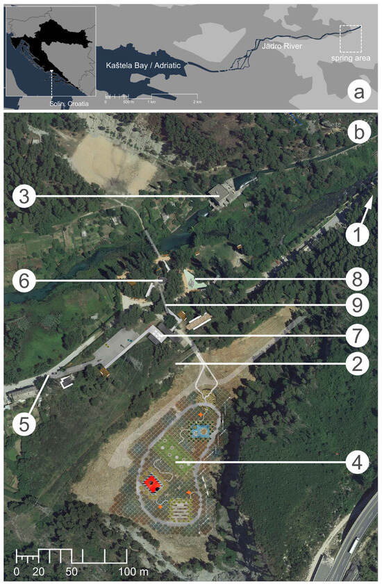
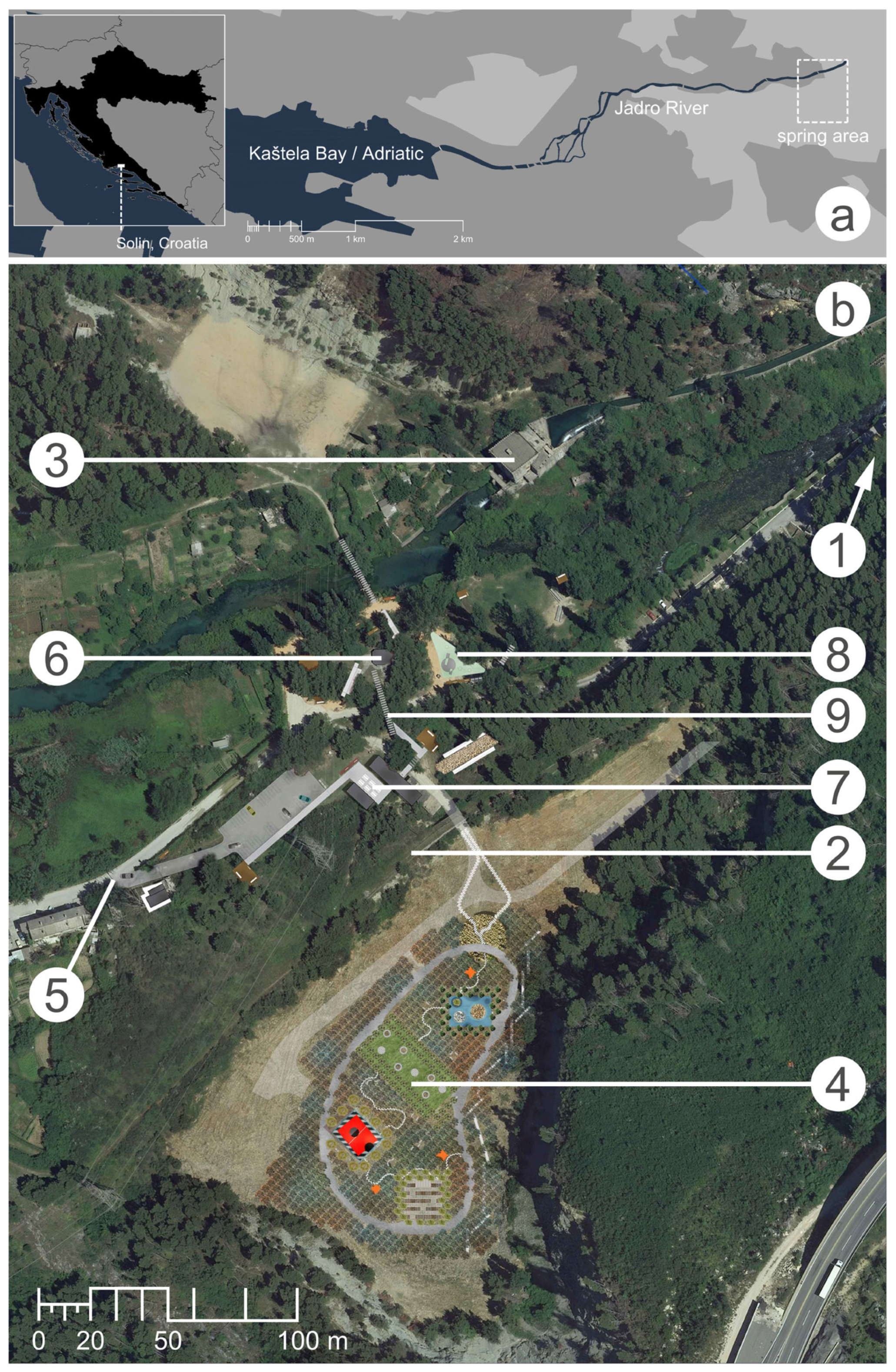
The analyzed project of redevelopment focused on the area around the spring of the river (Figure 1). The area of the Jadro River spring is characterized by significant natural and historical features. The site encompasses a karst watercourse, habitats of numerous protected species within a special ichthyological reserve, and historical elements, such as a Roman aqueduct, a former narrow-gauge railway, and a hydroelectric power plant from 1908. The development of the nearby workers’ settlement of Majdan is linked to a cement factory, with its associated transport infrastructure, including cable cars and conveyor belts that served nearby marl quarries. All these aforementioned layers made an imprint on the Jadro riverscape.
Figure 1.
Site context area. (a) Jadro spring in a wider context. Croatian base map edited by the authors; (b) surroundings of the excursion site: 1—Jadro spring; 2—Diocletian’s Aqueduct; 3—hydroelectric power plant; 4—Mayday! Majdan! Mayday! Park; 5—entrance point; 6—Interpretation Center/WWII bunker; 7—Visitor Center; 8—children’s playground; 9—new pedestrian bridge. Site plan produced by the authors overlaped with aerial photograph provided by Investor.
The total area of intervention spanned 1.2 hectares, with a portion in the northeast designated as a protected ichthyological reserve for the soft-mouth trout, an endemic species unique to this region. The boundary of this reserve, however, bisected the project area along a diagonal line, a division not based on natural topographical features. In addition to these ecological considerations, the site contained significant archaeological heritage, including the Roman aqueduct, a testament to the long history of human interaction with the site. Furthermore, a ruined bunker from World War II (WWII) was present on the site and was slated for reconstruction as part of the project. Evidence of past marlstone exploitation also existed within the project area. The intricate layering of these natural, historical, and potentially conflicting elements necessitated a design approach that was both sensitive and comprehensively integrated.
2.2. Methodology
The scope of the area of the redevelopment project makes it ideal for case study analysis, which has the aim to reveal the indicators for the successfulness of the (re)development of similar sites, thus contributing to the methodological approach for assessing and managing rivers as social–ecological systems. In investigating a case study as a research method, Zainal stated that the “Case study method enables a researcher to closely examine the data within a specific context. In most cases, a case study method selects a small geographical area or a very limited number of individuals as the subjects of study. Case studies, in their true essence, explore and investigate contemporary real-life phenomenon through detailed contextual analysis of a limited number of events or conditions, and their relationships.” [25] (pp. 1–2).
The authors of this article were involved as architects in designing the project of the redevelopment of the Jadro River spring area. As architects and authors, we described the planning and design aspects from our direct involvement in the project. This enabled the case study to have a special mode of observation, in which the investigators were not merely passive observers. Instead, our role was active within the case study situation, and the authors actually participated in the events being studied. According to Yin, participant observation provides certain unusual opportunities for collecting case study data, but it also involves major problems. The most distinctive opportunity is related to the ability to gain access to events or group work that are otherwise inaccessible to scientific investigation [26] (p. 93–96). Thus, as authors of the architectural project, we were involved in a series of meetings and discussions with different stakeholders of the redevelopment project during all phases of the project. This allowed us an opportunity to perceive redevelopment processes from the viewpoint of someone “inside” the case study rather than external to it. The major problems related to participant observation have to do with the potential biases produced. For this reason, the analysis was conducted three years after the completion of the redevelopment project. With this time lapse, we assessed the success of project concepts through measurable outcomes. To achieve an objective perspective, deliberate analysis parameters were selected to minimize designer bias and ensure rigorous evaluation.
The case study methodology was used to show the explanatory, not just the descriptive and exploratory, functions of the project [26] (p. 4). Furthermore, the lessons learned from this case study research were intended to be generalized not only to riverscape redevelopment but also to a wide variety of SESs. In the results of this paper, a protocol for (re)development of riverscapes as complex SESs was established and presented by analyzing the conceptual settings and the resulting impacts of the architectural and urban design interventions implemented at the Jadro River spring. The indicators within the protocol outline the critical ecological, social, and design factors that must be evaluated when planning and executing the (re)development of similar riverine sites.
A table with a corresponding scheme of analyses is presented in the Results Section, thus providing a framework that can be used or adapted for similar research studies.
2.3. Data and Materials
This single case study combines extensive documentation with the authors’ professional experience to analyze the redevelopment project in detail. This research examines planning records, design proposals, and implementation reports to understand the project’s development phases and the broader challenges of managing such interventions. The material used in the analysis originated from the documentation of the project “Jadro–Spring of Life”, all available in the archives of the City of Solin. Written progress reports for the redevelopment area were submitted to the authorized body in charge of monitoring and funding. Numerous regular coordination meetings were held with partners on the project and key stakeholders. The authors of this article were part of a team of experts from the FCEAG in Split and additional associates, who were responsible for developing the technical documentation needed to obtain a building permit and subsequent construction. All design and technical documentation about the redevelopment project is available in the archives of FCEAG in Split. The project and usage of the site were regularly followed by local news outlets, social media, and a newly established official website.
All sources of evidence were reviewed and analyzed together, so that the case study’s finding was based on the convergence of information from available sources and participant observation. Table 1 summarizes the primary site challenges addressed through targeted design responses in the redevelopment.
Table 1.
Narrative matrix of contextual constraints, design tensions, interventions, and outcomes in the Jadro River spring redevelopment project.
3. Results and Discussion
3.1. Description of the Site Area of the Project
The site area of the project lies within the administrative boundary of the City of Solin on the south bank of the upper Jadro River, with parts of it falling inside the protected ichthyological reserve. The reserve interfaces with residential blocks and industrial legacies to the west, the Diocletian Aqueduct corridor to the south, the Jadro River and the Klis Municipality boundary to the north, and regional water utility infrastructure to the east. The site overlaps broader ecological network areas significant for birds and lies near protected habitats, directing the project toward mitigation, habitat-compatible materials, and management of visitor pressure. The area of the source of the river is protected and managed by the local water supply company since it is still used as a source of drinking water. This area was excluded from the site area of the project, but maintenance access needed to be secured in the redevelopment of the site.
The topography of the site includes a flat river terrace, a central elevated knoll with a WWII bunker, and steeper slopes toward the aqueduct, with mature pines and riparian vegetation defining the landscape character. Municipalities’ land-use plans designate the area as a sports recreation center outside the settlement and as public and green areas, imposing limits on new buildings within the reserve.
The Diocletian Aqueduct is a nationally protected cultural asset immediately south of the project area, requiring spatial buffers, visual respect, and careful coordination of access routes. Beyond the aqueduct corridor, the previously designed Mayday! Majdan! Mayday! Park occupies the abandoned marl quarry as a brownfield remediation project.
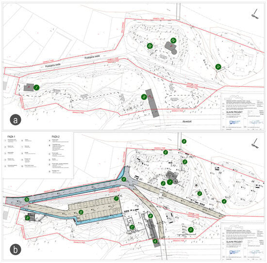
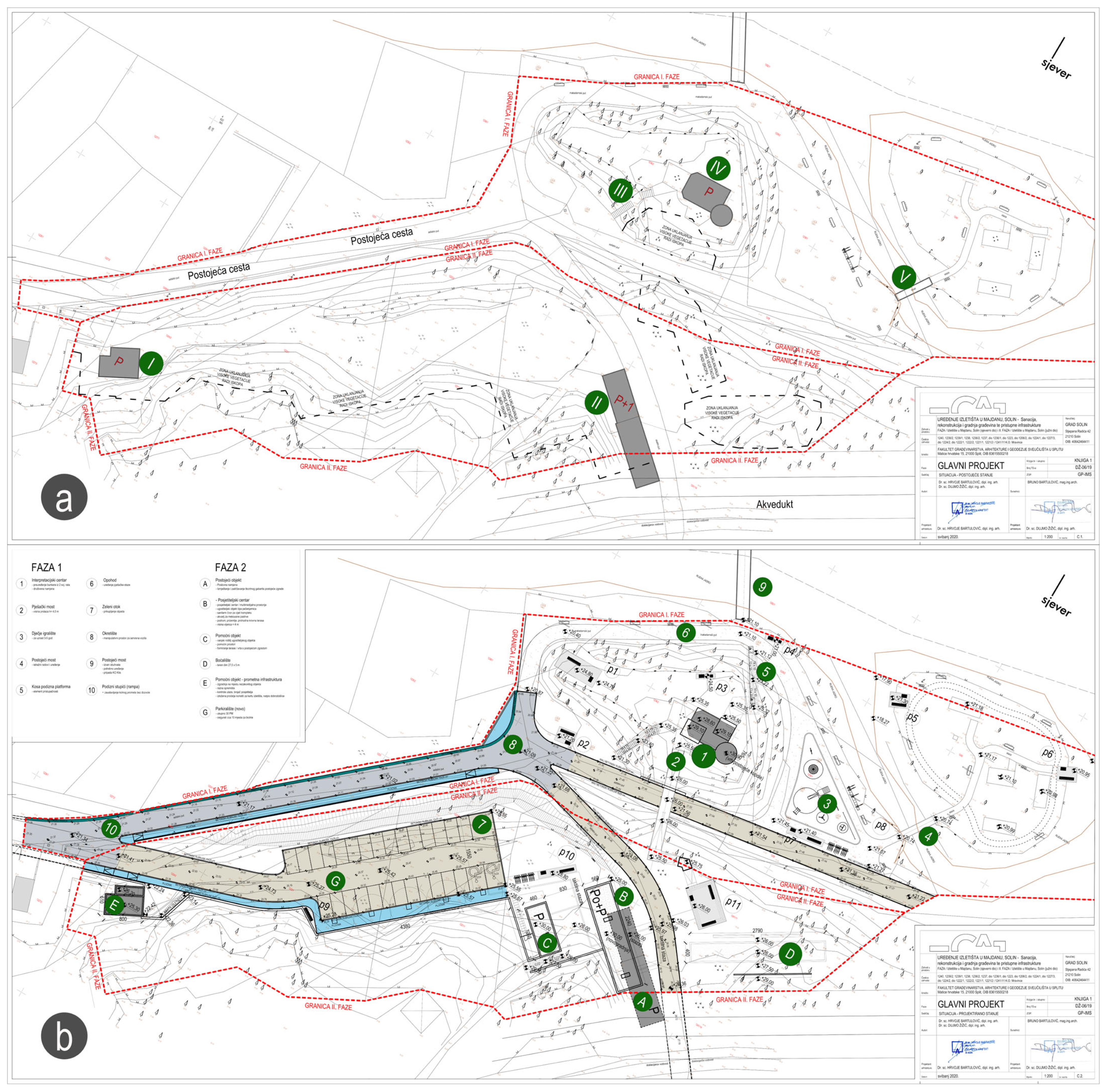
On the rest of the site area, a two-phase strategy is implemented (Figure 2). Phase I focuses on the reserve-adjacent north, emphasizing conservation-compatible upgrades: the Interpretation Center, educational paths and platforms, a refurbished pedestrian bridge, and a new accessible link to the south. Phase II consolidates visitor services in the south, with a new Visitor Center replacing a derelict structure, an auxiliary hospitality object, a bocce court, access control infrastructure, and a properly sited parking area. This spatial division into two zones ensures early implementation of environmental and safety measures in the less restricted recreational area while confining major built interventions outside the core protected reserve boundary.
Figure 2.
Site plan of the excursion site. (a) Site plan before intervention: I—unregulated makeshift structure; II—commercial-use building; III—staircase; IV—bunker; V—pedestrian bridge. (b) Site plan with designed elements: PHASE 1: 1. Interpretation Center, conversion of a WWII bunker; 2. pedestrian bridge; 3. children’s playground; 4. existing bridge; 5. inclined lifting platform; 6. perimeter walkway; 7. recycling island; 8. turnaround; 9. existing bridge; 10. retractable bollards. PHASE 2: A. existing building; B. Visitor Center; C. auxiliary building; D. bocce court; E. auxiliary building—transport infrastructure; G. parking lot (new). Knowledge platforms: p1–p11. Excerpt from architectural project, designed by the authors for Faculty of Civil Engineering, Architecture and Geodesy in Split, Croatia.
The design plan of the project structures the site as a continuous day-use park with distinct yet connected program clusters: interpretation on the northern knoll, services and gathering around a central terrace, and mobility control at the western entry. As a part of an established network of pedestrian pathways, a new pedestrian bridge reinstates the historical industrial conveyor trajectory as a gentle cross-site movement spine, improving legibility and accessibility without fragmenting habitats. Educational posts, called “platforms of knowledge”, punctuate pedestrian trails as outdoor classrooms, reinforcing a slow, exploratory visitor experience aligned with protection objectives.
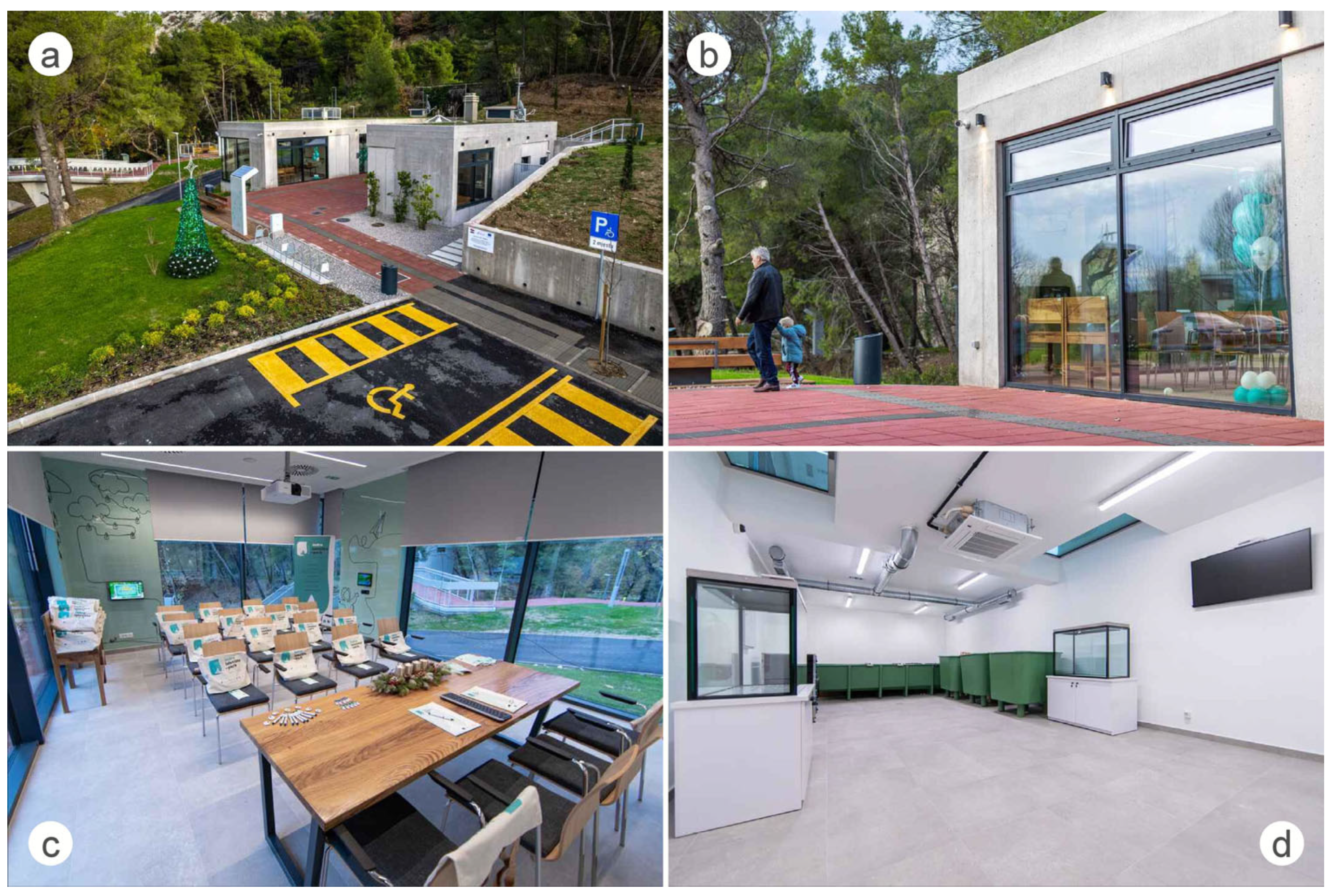
The new Visitor Center replaces an abandoned and derelict industrial building of low value with a similar footprint and a single-story volume over a basement, organizing exhibition, orientation, and public sanitation at grade with a technical and educational soft-mouth trout hatchery below (Figure 3). A passage links parking and the central terrace toward the river link and bocce court, ensuring continuous pedestrian permeability through the building. The envelope strategy favors exposed concrete with selective interior insulation, durable surface finishes, and an extensive green roof to moderate microclimate and reduce runoff, as a sustainable solution to daily usage rhythms. A small, single-story auxiliary pavilion offers modest food preparation and service oriented to the central terrace, volumetrically harmonized with the Visitor Center. Programmatic components include a serving area, preparation back-of-house, a grill zone, storage, and staff sanitary facilities, dimensioned for seasonal peak without encouraging car-oriented overuse. Materials and detailing mirror the Visitor Center for visual coherence while maintaining a lightweight operational footprint. The building heights and massing are intentionally set under the aqueduct to safeguard heritage sightlines and prevent visual intrusion.
Figure 3.
Visitors Center: (a) wider context; (b) square; (c) main hall; (d) soft-mouth trout hatchery. River Jadro. Available online: https://jadro-izletiste.hr/en/natural-heirdom/river-jadro/ (accessed on 17 February 2025), graphical abstract.
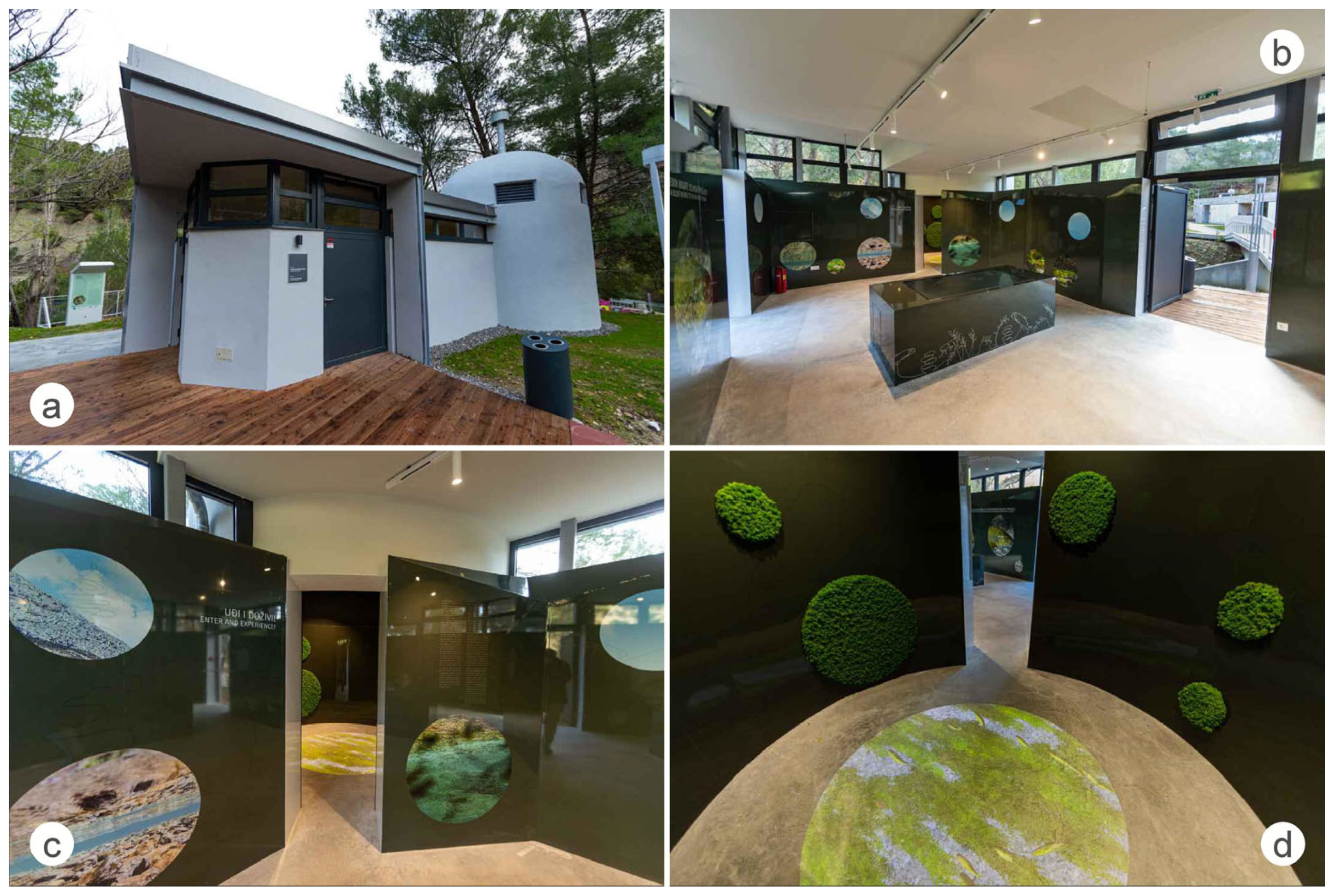
The WWII bunker is reconstructed and adaptively reused as a compact Interpretation Center with improved daylighting and natural ventilation, preserving the concrete shell and dome and inserting a new roof structure on the rest of the bunker (Figure 4). An internal “Nature Periscope” within the existing dome aperture enables immersive interactive projection, supporting curriculum-aligned programming for various age groups. External terraces on the knoll support small group activities and observation while maintaining low visual impact through material and massing restraint.
Figure 4.
WWII bunker/Interpretation Center: (a) new roof and preserved dome; (b) interaction within main area; (c) educational wall panels; (d) “Nature Periscope” with interactive projection. River Jadro. Available online: https://jadro-izletiste.hr/en/natural-heirdom/river-jadro/ (accessed on 17 February 2025), graphical abstract.
A compact children’s play area near the northern paths employs certified equipment, impact-attenuating natural aggregates and targeted rubber insets, and durable site furnishings. The design avoids fencing within the pedestrianized zone while defining edges and drainage through flush curbs and graded surfaces. A regulation-scaled bocce court provides local recreational continuity of decades-long tradition with integrated seating and robust finishes.
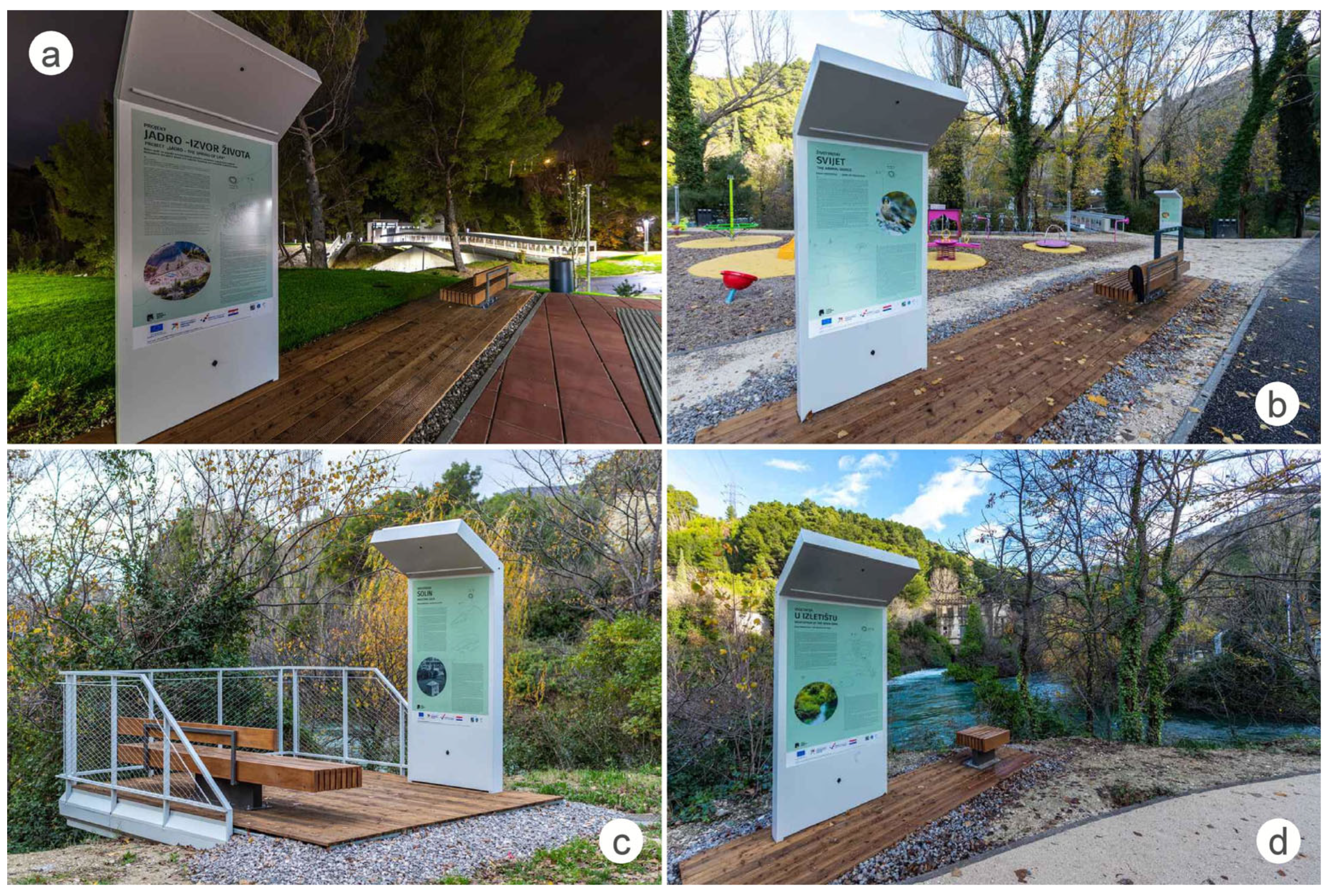
The sense of place translates into operational criteria through design choices that encourage slow exploration while evoking the site’s complex heritage. The materialization of elements aligns with their intended use. Surface materials are selected for permeability, color neutrality, and compatibility with protected habitats. Primary trails are stabilized mineral surfaces compatible with the nature reserve, with local concrete segments where slopes require precise grades for accessibility compliance. “Platforms of knowledge” combine an info totem with integrated photovoltaic (PV) and lighting, seating, and a timber deck on an elevated concrete slab, positioned for education and habitat viewing (Figure 5). Where needed, low mesh guardrails are integrated to meet fall protection standards without introducing visual clutter.
Figure 5.
“Platforms of knowledge” with specific themes. (a) “Jadro–Spring of Life” by the main square. (b) “Animal kingdom” by the children’s play area. (c) “Industrial heritage” overlooking a nearby marl quarry. (d) “Plant life inside excursion site” overlooking the powerplant. River Jadro. Available online: https://jadro-izletiste.hr/en/natural-heirdom/river-jadro/ (accessed on 17 February 2025), graphical abstract.
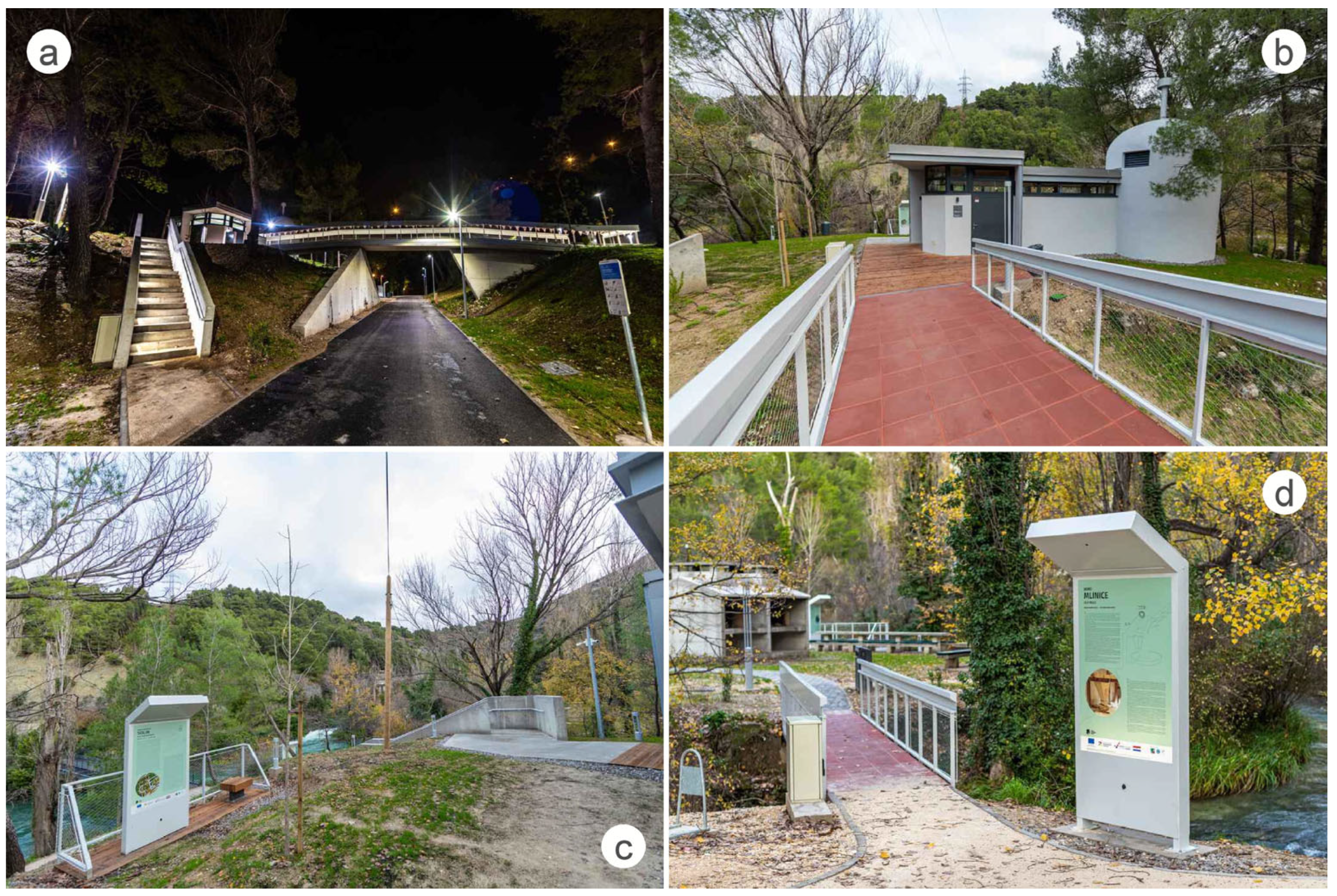
A new pedestrian bridge on concrete supports in place of former conveyor supports connects the Interpretation Center and Visitor Center precincts, with adequate clearance over the service road. An existing improvised steel footbridge is replaced with a robust concrete deck and proper supports, improving safety, width, and durability for all users. The bridge surface finishes prioritize slip resistance and low maintenance, with lighting embedded in handrails to minimize lightning pollution (Figure 6).
Figure 6.
Pedestrian communication system. (a) Bridge over the service/access road; (b) continuity of walkways on a central elevated knoll; (c) top station of an accessibility platform; (d) refurbished pedestrian bridge over a Jadro branch. River Jadro. Available online: https://jadro-izletiste.hr/en/natural-heirdom/river-jadro/ (accessed on 17 February 2025), graphical abstract.
Roof and surface runoffs are directed to controlled discharge via inlets and the public drainage system. Public water and sanitation are centralized in the Visitor Center, while the Interpretation Center intentionally avoids plumbing and Heating, Ventilation, and Air Conditioning (HVAC) installations to limit service impacts within the reserve. No new process effluents or polluting technologies are introduced, aligning operations with water quality protection goals.
Robust in situ concrete, modeled and stabilized terrain surfaces, and timber decking are the primary palette, supporting longevity, reparability, and contextual fit. Green roofs on new buildings moderate heat gain, improve acoustic comfort under rain, and visually blend newly introduced volumes into the landscape. Selective demolition and structural replacement address the bunker’s defective flat slab while preserving the structurally sound dome and perimeter walls, adding a new steel roof frame on discrete supports. Facade openings employ thermally broken profiles with low-emissivity glazing in conditioned areas, while unconditioned spaces prioritize ventilation and shading. New buildings and bridges rely on conventional reinforced concrete footings, slabs, and walls sized for local geotechnical conditions and durability in outdoor exposure. Retaining walls and terrace edges are cast-in-place concrete with simple joints and water-tight admixtures to protect against seepage and freeze–thaw cycles.
The project connects to the electrical distribution network, with distributed low-glare lighting embedded in handrails and select totems for safety and interpretation. Select interpretation totems integrate small PV modules for autonomous backlit content and charging in supervised zones. Lighting follows a “dark-sky” ethos with low mounting heights, warm color temperatures, and concealed fixtures to minimize spill into habitats and avoid glare for pedestrians. Bridge and handrail lighting offers pathway luminance without uplight, and platform lighting operates on motion detection to reduce energy and wildlife disturbance. Entry lighting concentrates at the control point and parking, tapering rapidly toward the reserve interior.
Vehicular access is restricted by automated bollards near the western approach, admitting only service, utility, and emergency vehicles, thereby de-motorizing reserve interiors. A compact relocated parking area on the south includes accessible bays and clustered bicycle stands. This shift removes informal riverbank parking—previously a major source of detergent and oil leaks—thereby eliminating pollutant risks and restoring sensitive riparian edges.
Planting accentuates existing pine trees and riparian vegetation with compatible native species, favoring biodiversity, shade, and low-input maintenance. Grading and low retaining structures reconcile accessibility slopes with minimal earthworks, preserving natural banks and existing mature trees wherever possible.
Pedestrian movement is prioritized through a legible sequence of entries, shaded paths, bridges, and terraces, minimizing conflict with essential service access. Wayfinding consolidates orientation at the entry and “platforms of knowledge,” reducing sign proliferation and protecting visual calm. “Off-road stories”, with additional information about the site, are implemented as a series of single wooden columns dispersed around the site area to further encourage sightseeing and deepen knowledge of the location.
The network of pathways is designed to minimize barriers, adding a new low-slope bridge link and a stair-integrated inclined platform lift to overcome key elevation changes. Accessible bays, compliant sanitary facilities in the Visitor Center, and continuous stable surfaces enable inclusive access across principal destinations.
The measures comply with national accessibility regulations for public paths and sanitary facilities, adapted to the park typology.
During operation, standard municipal solid waste handling applies, with clustered bins at the parking edge and service core to avoid littering in sensitive areas. Collections are coordinated with the local utility, and refuse storage is positioned to avoid odors and vehicle conflict during peak visitation. No hazardous or processed waste is generated by the programmed uses.
Relocating parking spaces away from the river removes episodic pollution sources such as washing and oil leaks from the riparian zone. The limited added footprint within the reserve, using low-impact trail materials, and shading from retained pines, reduces heat islands and erosion potential. Visitor flow is structured to prevent trampling and to keep groups on decks and platforms designed for education and observation.
The Diocletian Aqueduct corridor is respected through controlled access, compatible viewing routes, and visual subordination of new masses. The WWII bunker is conserved and repurposed, transforming a war relic into a civic learning device without falsifying its material authenticity. Interpretation content connects hydro-heritage, ecology, and local industry legacies to contextualize landscape change.
Outdoor “platforms of knowledge” combine durable seating, deck space, and info media to host small classes in situ, supported by the Visitor Center’s exhibition space. The “Nature Periscope” provides an iconic yet subtle immersive device to engage visitors with habitats without intrusive viewing towers. The content strategy addresses species and habitats, hydrology, industrial transformations, and stewardship practices suitable for school curricula.
The program accommodates family outings, school excursions, and casual recreation, with intensity focused away from the reserve core to protect sensitive zones. Bocce and picnic amenities reflect local customs, while bicycle parking and shaded paths support low-carbon, health-positive use patterns.
The Visitor Center’s sanitary and orientation services serve both local residents and regional visitors year-round. Access control and visitor counting at the entry support ongoing monitoring of carrying capacity and peak management. Maintenance-friendly materials and consolidated services reduce lifecycle costs and failure points in the public park setting. Green roofs and permeable surfaces contribute to runoff attenuation and microclimate performance, measurable through standard facility management protocols. The entry control pavilion provides the operational node for regulating vehicular access, coordinating with the water utility for service movements. Cleaning, waste collection, and minor repairs concentrate around the southern core to minimize vehicular trips into the reserve. The clear delineation of responsibilities across city services and park operations underpins long-term stewardship.
The adaptive reuse of a bunker as an Interpretation Center demonstrates how small, robust insertions can unlock educational value within protected landscapes. Stabilized mineral paths, integrated handrail lighting, and autonomous interpretation totems present transferable components for low-impact parks.
Phasing that prioritizes conservation and safety while deferring larger volumes outside protected cores offers a pragmatic blueprint for similar riverine sites. The Jadro redevelopment project couples conservative construction in sensitive and protected zones with consolidated services on more resilient ground, delivering a coherent, inclusive, and educational public landscape. By aligning access management, habitat-compatible materials, adaptive reuse, and curriculum-ready interpretation, the project advances a replicable protocol of riverpark renewal in ecologically constrained contexts.
3.2. Change in Perception and Usage
Before the development, the picnic area was burdened by pressures from inadequate use, such as poaching, car washing, and intensive agricultural practices, which led to the pollution of watercourses and the endangerment of animal and plant species in the soft-mouthed trout habitat. The guard service of the public forestry institution responsible for managing the area recorded more intensive use of the picnic area on weekends, after which the area would be full of garbage due to the lack of adequate visitor infrastructure. All of the above threatened the preservation of the reserve [27].
The area was isolated from the urban fabric and, through the prism of industrial heritage, two large quarries and a former cement factory were perceived as unattractive to visitors. Despite this, the local population had a need to visit this traditional picnic area that has been unfairly marginalized for decades. The local population and interest groups were involved in the development of the project proposal, and the enthusiasm with which the project was expected to be implemented was noticeable. Therefore, throughout the project implementation, various stakeholders were included in a series of participatory meetings to ensure adequate spatial frameworks for their preferred activities. A number of different experts were involved in the design process to create the necessary content. An interpretation plan was developed, and elements of the permanent exhibition were elaborated.
As part of the project, a series of educational multimedia content about the spring of the Jadro River was created, and dissemination was ensured through communication and promotional content at numerous events [28].
With the implementation of the project, the former informal family picnic area became a modern oasis for teaching, learning, research, recreation, and relaxation of visitors, and the much-needed protection of natural values and adequate use of space were ensured [29,30].
The current management of the picnic area is regulated by a management plan adopted by the City of Solin. In addition to daily visits, the picnic area offers organized visits to educational institutions, associations, and societies with educational guides and customized workshops. A visit to the Jadro excursion site, as part of an educational package, includes a tour of the site with an expert guide (presentation of soft-mouthed trout, an endemic species of the Jadro River, the ecological and cultural values of the Jadro River, the soft-mouth trout spawning grounds, a converted bunker from WW II, and outdoor facilities) and a number of different workshops. It is also possible to organize children’s birthday parties, rent sports equipment, and rent barbecues in designated areas [31].
Rules of conduct have been established, in which the following are prohibited: swimming, performing underwater activities, picking and damaging plants, disposing of all types of waste (except in designated containers), fishing, lighting fires, barbecues (except in designated areas), camping, feeding fish, walking dogs without a leash, and flying a drone [32]. Various events are organized in the park inside the reclaimed marl quarry, such as a music festival, ice skating rink, an Advent fair, etc. The picnic area was accepted by the public and became a new point of social life for the local population and the wider urban area [33]. Table 2 illustrates how project interventions deliver synergistic benefits across ecological protection, social engagement, and operational efficiency.
Table 2.
Synergistic performance matrix of interventions across ecological, social, and operational SES dimensions.
3.3. Design Protocol for Riverscape Social–Ecological Systems
The results of this case study provide compelling evidence supporting the working hypothesis that integrating heritage interpretation, blue–green infrastructure, and formalized access within a coherent social–ecological system (SES) framework can simultaneously protect fragile headwater ecosystems and enhance public value. The Jadro spring redevelopment demonstrates that alignment of physical infrastructure, interpretive narratives, and access management creates a synergistic system where human behavior and ecological processes coalesce in a mutually reinforcing manner. This adaptive integration is fundamental for preserving biodiversity—particularly of endemic species like the soft-mouth trout—while fostering community connection and environmental stewardship. The ongoing participatory data collection and monitoring, deeply embedded in the project’s governance, further illustrate how embedded stakeholder engagement enhances both ecological outcomes and social inclusion, thus validating the SES paradigm espoused in the recent literature on urban riverscapes as complex adaptive systems [2] (p. 8), [6] (p. 5).
From the interpretive perspective, the Jadro ensemble marks a paradigm shift away from object-centric conservation toward process-led SES governance, wherein heritage and blue–green infrastructure are co-producers of stewardship and resilience. This contrasts previous conservation models that treated heritage as static artifacts, instead positioning cultural and ecological layers within a living, evolving system. Such an approach aligns with the findings of Lopez et al. (2023) on ecosystem service integration and Gottwald et al. (2022) on sense of place, corroborating that biophysical and social dimensions are inextricably linked [5] (p. 201), [7] (p. 634). The deliberate choreography of visitor routes, landmarks, and interpretive nodes presents a model for SES-informed placemaking, dissolving administrative discontinuities and enhancing governance coherence. The project thus contributes substantively to the growing body of evidence advocating SES frameworks as superior means for river basin management that simultaneously achieve biodiversity protection, cultural preservation, and sustainable recreational use.
Importantly, the Majdan case offers a transferable, replicable pilot framework for other marl quarry and small headwater SES projects (Table 3). The staged sequence—from reclamation of degraded industrial land as an educational common to its connection with active river corridors and interpretive infrastructure—establishes a methodological scaffold that can be adapted across similar biophysical and socio-cultural contexts. The EU project documentation, interpretive content, and operational templates provide a modular toolkit for governance clarity, procurement procedures, and community engagement, which are essential for effective SES management in Adriatic and Mediterranean river settings. This highlights the project’s scalability potential, allowing municipalities and conservation bodies to leverage experiential knowledge and technical guidance to address challenges in complex SES riverscapes.
Table 3.
This study’s main results through the lens of SES theory and practice, highlighting their broader relevance and utility as a foundational case for future research and implementation.
The established design protocol offers broad transferability for urban riverpark renewal, with elements applicable to any ecologically constrained headwaters facing informal misuse. Site-specific aspects derived from the karst geological specifics and resulting complex contextual layers limit direct replication in alluvial or uniform river systems. Implementation succeeded through Croatian EU funding synergies (ERDF Jadro-Spring of Life, Interreg RiTour), multi-stakeholder coordination (Public Institution Sea and Karst, City of Solin, FCEAG Split), and pre-existing land-use plans designating green/public zones, ensuring technical expertise and future governance.
Despite the successes, post-implementation observations reveal potential challenges: increased visitor numbers have sparked resident complaints in adjacent Majdan about parking overflow and noise, suggesting risks to surrounding areas; carrying capacity monitoring at entry bollards addresses this but requires vigilant enforcement. The strict rules of conduct mitigate misuse but demand ongoing stewardship to prevent rebound effects.
Future research should extend the Jadro protocol through hybrid governance models integrating ecosystem assessments (as in Córdoba Hernández & Camerin, 2024), community-led monitoring of soft-mouth trout habitats and visitor flows, and longitudinal behavioral analysis to track carrying capacity thresholds [34]. Contrasting Jadro’s SES approach with their methodology—mapping ecosystem services via crosswalks to justify protection against land-use pressures—highlights synergies for valuing karst headwater services under climate scenarios, advancing EU-integrated urban river management.
4. Conclusions
The findings underline the broader applicability of SES principles to urban river landscapes, particularly where ecological sensitivity coincides with layered cultural heritage and post-industrial legacies. The integration of human–nature interactions as feedback loops, emphasizing adaptive governance and participatory stewardship, reinforces contemporary calls for holistic, transdisciplinary river management strategies. Additionally, the observed interplay between social factors, like cultural identity, sense of place, and community cohesion, and ecological outcomes confirms SES theory predictions and extends its practical implementation in urban renewal contexts. Hence, this single case study, underpinned by participatory co-creation and longitudinal monitoring, contributes valuable insights that transcend local boundaries and offer conceptual and empirical guidance for future SES redevelopment efforts.
Despite these strengths, the Jadro project faced limitations, including funding constraints that delayed full implementation of monitoring systems and challenges in balancing visitor access with ichthyological reserve protections, where strict ecological regulations limited certain interventions. The ichthyological reserve remained the project’s core focus, driving design decisions to prioritize non-invasive materials and zoning that safeguarded endemic species’ habitats amid recreational demands.
The Jadro River spring redevelopment demonstrates how small-scale infrastructure—walkways, interpretive centers, and signage—can drive behavioral shifts from misuse to stewardship while enhancing ecological resilience in sensitive karst headwaters. Future research should build upon this foundation by broadening comparative SES case studies across varying geographic, climatic, and cultural settings to examine the robustness and limits of the Jadro model. Systematic integration of ecological and social data streams, including ethnographic methods and biotic monitoring, will foster adaptive learning and refine management protocols for different SES typologies. Moreover, exploring the effects of varying intensities of access regulation, interpretive engagement, and heritage integration on SES resilience metrics will provide a nuanced understanding of context-dependent strategies. Given accelerating global urbanization and biodiversity loss, the urgency of developing resilient SES frameworks for river landscapes cannot be overstated. The participatory, data-driven approach exemplified here can guide scalable, inclusive, and ecologically grounded urban environmental governance in diverse settings worldwide.
Author Contributions
Conceptualization, H.B. and D.Ž.; methodology, H.B. and D.Ž.; investigation, H.B. and D.Ž.; resources, H.B. and D.Ž.; writing—original draft preparation, H.B. and D.Ž.; writing—review and editing, H.B. and D.Ž.; visualization, H.B. and D.Ž. All authors have read and agreed to the published version of the manuscript.
Funding
This research received no external funding.
Data Availability Statement
The data presented in this study are available on request from the corresponding author, the data are not publicly available due to they are the Third-Party Data.
Acknowledgments
This research was partially supported through the project KK.01.1.1.02.0027, a project co-financed by the Croatian Government and the European Union through the European Regional Development Fund—the Competitiveness and Cohesion Operational Programme.
Conflicts of Interest
The authors declare no conflicts of interest.
Abbreviations
The following abbreviations are used in this manuscript:
| SES | Social–ecological systems |
| IUCN | International Union for Conservation of Nature |
| RERA S.D. | Public Institution for coordination and development of the Split-Dalmatia County |
| CC | Climate change |
| FCEAG | Faculty of Civil Engineering, Architecture and Geodesy in Split, Croatia |
| WWII | World War II |
| PV | Photovoltaic |
| HVAC | Heating, Ventilation, and Air Conditioning |
References
- Secretariat of the Convention on Biological Diversity. Kunming-Montreal Global Biodiversity Framework. In Proceedings of the Parties to the Convention on Biological Diversity, Fifteenth Meeting, Part II, Montreal, QC, Canada, 7–19 December 2022; pp. 1–15. [Google Scholar]
- Perry, D.; Praskievicz, S.; McManamay, R.; Saxena, A.; Grimm, K.; Zegre, N.; Bair, L.; Ruddell, B.L.; Rushforth, R. Resilient riverine social–ecological systems: A new paradigm to meet global conservation targets. WIREs Water 2024, 11, e1753. [Google Scholar] [CrossRef] [Scilit]
- Sayer, C.A.; Fernando, E.; Jimenez, R.R.; Macfarlane, N.B.W.; Rapacciuolo, G.; Bhm, M.; Brooks, T.M.; Contreras-MacBeath, T.; Cox, N.A.; Harrison, I.; et al. One-quarter of freshwater fauna threatened with extinction. Nature 2025, 638, 138–145. [Google Scholar] [CrossRef] [Scilit] [PubMed]
- Sargolini, M.; Sopina, A.; Polci, V.; Mariani, D.; Paolini, C.; Mariani, M. Integrating Urban Design, Healthy Habits, and Socio-Ecological Networks: A One Health and Well-Being Framework for Sustainable Cities. Sustainability 2025, 17, 10014. [Google Scholar] [CrossRef] [Scilit]
- Lopez, C.W.; Wade, M.T.; Julian, J.P. Nature–Human Relational Models in a Riverine Social–Ecological System: San Marcos River, TX, USA. Geographies 2023, 3, 197–245. [Google Scholar] [CrossRef] [Scilit]
- Dunham, J.B.; Angermeier, P.L.; Crausbay, S.D.; Cravens, A.E.; Gosnell, H.; McEvoy, J.; Moritz, M.A.; Raheem, N.; Sanford, T. Rivers are social–ecological systems: Time to integrate human dimensions into riverscape ecology and management. WIREs Water 2018, 5, e1291. [Google Scholar] [CrossRef] [Scilit]
- Gottwald, S.; Albert, C.; Fagerholm, N. Combining sense of place theory with the ecosystem services concept: Empirical insights and reflections from a participatory mapping study. Landsc. Ecol. 2022, 37, 633–655. [Google Scholar] [CrossRef] [Scilit]
- Williams, D.R.; Stewart, S. Sense of Place: An Elusive Concept That is Finding a Home in Ecosystem Management. J. For. 1998, 96, 18–23. [Google Scholar] [CrossRef] [Scilit]
- River Jadro. Available online: https://jadro-izletiste.hr/en/natural-heirdom/river-jadro/ (accessed on 17 February 2025).
- Jadro—A Small River of Vital Importance. Available online: https://solin-info.com/en/znamenitosti/solin-danas/rijeka-jadro (accessed on 13 February 2025).
- Ignjatić Zokić, T.; Miletić, B.; Cvetnić, M.; Markić, M.; Kučić Grgić, D.; Prevarić, V. Pilot research using multi-layer filtration of water from the Jadro source. Hrvat. Vode 2020, 28, 197–204. Available online: https://hrcak.srce.hr/249864 (accessed on 19 February 2025).
- Marasović, K.; Margeta, J. A study of Roman water intake structures at the Jadro River’s spring. Vjesn. Arheol. Hist. Dalm. 2017, 110, 509–532. Available online: https://hrcak.srce.hr/193169 (accessed on 19 February 2025).
- Solin—Town History. Available online: http://www.solin-info.com/en/znamenitosti/povijest-grada (accessed on 13 February 2025).
- Jadro—Izvor Života. Available online: https://www.solin.hr/upravni-odjeli/upravni-odjel-za-gospodarstvo-zastitu-okolisa-i-europske-fondove/zavrseni-projekti/jadro-izvor-zivota/ (accessed on 19 February 2025). (In Croatian)
- About the Project. Available online: https://jadro-izletiste.hr/en/about-us/about-the-project/ (accessed on 19 February 2025).
- Tomljanović, T. Endemska mekousna pastrva solinka (Salmo obtusirostris salonitana). Tusculum 2014, 7, 215–224. Available online: https://hrcak.srce.hr/128484 (accessed on 19 February 2025).
- Project: Jadro—Spring of Life. Available online: https://solin-info.com/en/znamenitosti/solin-danas/projekt-jadro-izvor-zivota (accessed on 19 February 2025).
- O Projektu/About the Project. Available online: https://maydaymajdanmayday.wordpress.com/o-projektu/ (accessed on 19 February 2025).
- Eremut, A.; Bartulović, H.; Žižić, D. Revitalizacija Napuštenoga Tupinoloma u Majdanu. Tusculum 2015, 8, 269–281. Available online: https://hrcak.srce.hr/148911 (accessed on 19 February 2025).
- RiTour. Available online: https://interreg-hr-ba-me.eu/2014/project/ritour// (accessed on 19 February 2025).
- Change We Care. Available online: https://programming14-20.italy-croatia.eu/web/changewecare (accessed on 19 February 2025).
- Improve River LIFE—Improving Degree of Conservation of Natura 2000 Target Species and Habitat Types Through Improvement of River Connectivity. Available online: https://lifeprogramhrvatska.hr/en/projects/improve-river-life-improving-degree-of-conservation-of-natura-2000-target-species-and-habitat-types-through-improvement-of-river-connectivity/ (accessed on 28 October 2025).
- Divić, V.; Galešić, M.; Di Dato, M.; Tavra, M.; Andričević, R. Application of Open Source Electronics for Measurements of Surface Water Properties in an Estuary: A Case Study of River Jadro, Croatia. Water 2020, 12, 209. [Google Scholar] [CrossRef] [Scilit]
- Kadić, A.; Denić-Jukić, V.; Jukić, D. Exceeding Turbidity versus Karst Spring Discharge during Single Rainfall Events: The Case of the Jadro Spring. Water 2023, 15, 2589. [Google Scholar] [CrossRef] [Scilit]
- Zaidah, Z. Case Study as a Research Method. J. Kemanus. 2007, 9, 1–6. [Google Scholar]
- Yin, R.K. Case Study Research: Design and Methods, 3rd ed.; Sage: Thousand Oaks, CA, USA, 2003. [Google Scholar]
- Svakodnevni Problemi Stanovnika Majdana Zbog sve Većeg Broja Posjetitelja Izletišta na Izvoru Jadra. Available online: https://zvonimirsolin.hr/istaknuto/svakodnevni-problemi-stanovnika-majdana-zbog-sve-veceg-broja-posjetitelja-izletista-na-izvoru-jadra-dobro-pripremiti-a-zatim-urediti/ (accessed on 20 October 2025). (In Croatian)
- Plenković u Solinu: Revitalizacija Područja Izvora Rijeke Jadro Emancipirat će Prirodnu i Kulturnu Baštinu Ovoga Kraja. Available online: https://vlada.gov.hr/vijesti/plenkovic-u-solinu-revitalizacija-podrucja-izvora-rijeke-jadro-emancipirat-ce-prirodnu-i-kulturnu-bastinu-ovoga-kraja/26007 (accessed on 20 October 2025). (In Croatian)
- U Solinu Otvoreno Moderno i Suvremeno Opremljeno Izletište uz Izvor Jadra. Available online: https://www.solin.hr/novosti/u-solinu-otvoreno-moderno-i-suvremeno-opremljeno-izletiste-uz-izvor-jadra/ (accessed on 22 October 2025). (In Croatian)
- Svečano Otvoreno Novo Izletište uz Rijeku Jadro. Available online: https://www.dalmacijadanas.hr/svecano-otvoreno-novo-izletiste-uz-rijeku-jadro-posjetitelje-ce-oduseviti-sadrzajem-za-sve-generacije-interpretacijski-centar-igraliste-bocaliste-ugostiteljski-objekt/ (accessed on 22 October 2025). (In Croatian)
- About Us. Available online: https://jadro-izletiste.hr/en/about-us/ (accessed on 23 October 2025). (In Croatian)
- Rules of Conduct. Available online: https://jadro-izletiste.hr/en/plan-your-visit/rules-of-conduct/ (accessed on 23 October 2025).
- U Petak na Izletištu Jadro Počinje Božićna Bajka, Otvara se Klizalište, a Stiže i Sveti Nikola! Available online: https://www.solin.hr/novosti/u-petak-na-izletistu-jadro-pocinje-bozicna-bajka-otvara-se-klizaliste-a-stize-i-sveti-nikola/ (accessed on 23 October 2025). (In Croatian)
- Córdoba Hernández, R.; Camerin, F. The application of ecosystem assessments in land use planning: A case study for supporting decisions toward ecosystem protection. Futures 2024, 161, 103399. [Google Scholar] [CrossRef] [Scilit]

Disclaimer/Publisher’s Note: The statements, opinions and data contained in all publications are solely those of the individual author(s) and contributor(s) and not of MDPI and/or the editor(s). MDPI and/or the editor(s) disclaim responsibility for any injury to people or property resulting from any ideas, methods, instructions or products referred to in the content. |
© 2025 by the authors. Licensee MDPI, Basel, Switzerland. This article is an open access article distributed under the terms and conditions of the Creative Commons Attribution (CC BY) license.