Reconstruction of Cultivated Land Dynamics in the Yellow River Delta Basin Since 1855
Abstract
1. Introduction
2. Overview of the Study Area
3. Data Sources and Research Methods
3.1. Data Sources
- Vector data of the lower Yellow River channel from 1855 to the present
- 2.
- Coastline data of the Yellow River Delta
- 3.
- Cultivated land area data
- 4.
- Other basic data required for cultivated land gridding allocation
3.2. Research Methods
3.2.1. Key Factor Discrimination Method Based on Historical Settlement Density
- (1)
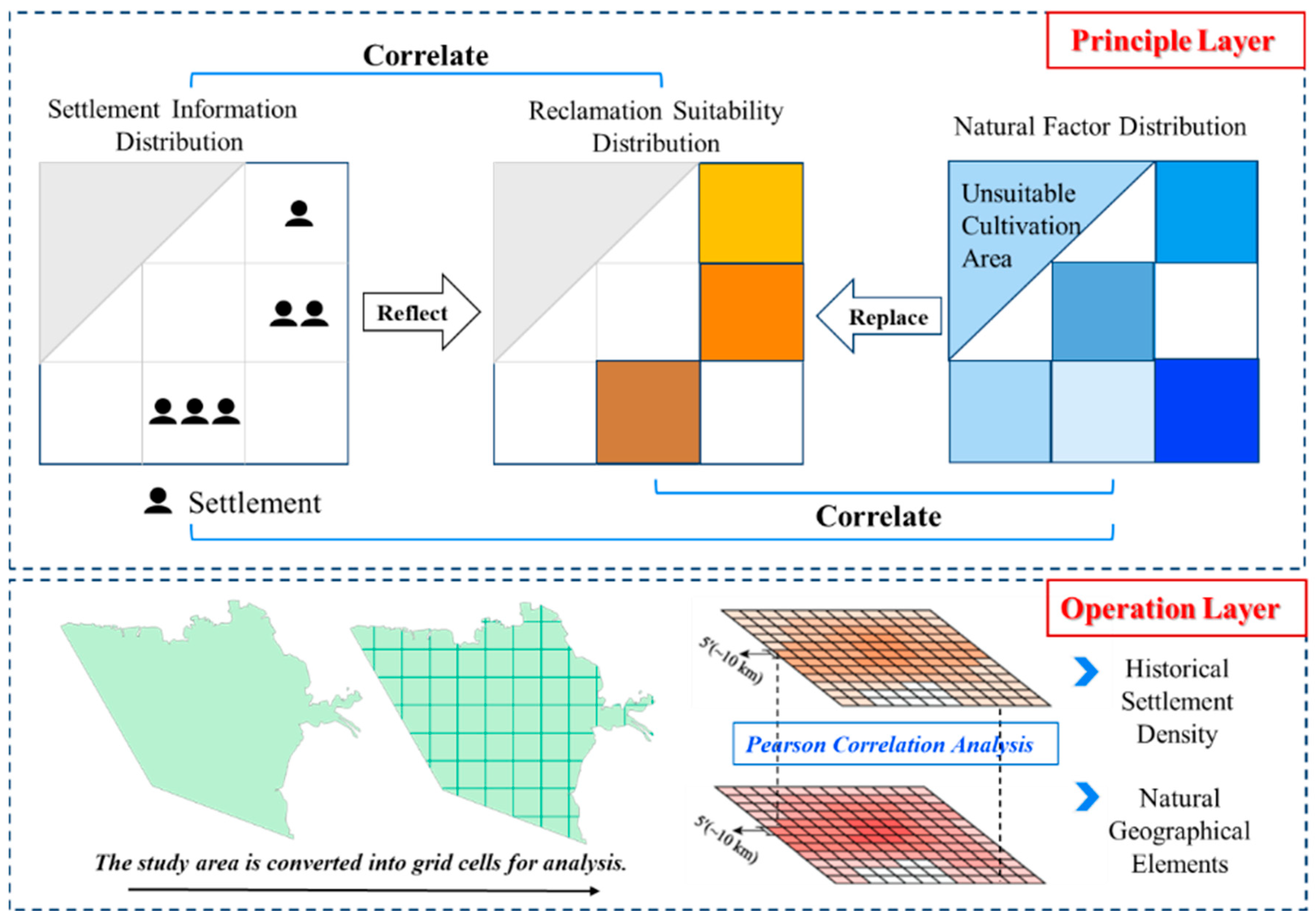
- Spatial scale unification: Physical geographic elements (such as topography, climate, soil, etc.) have multi-scale characteristics. To ensure the consistency of analysis, the spatial resolution of each element index is first unified, and 10 km × 10 km (5′ × 5′) is selected as the analysis scale. This scale can effectively cover regional natural condition differences and avoid information redundancy caused by excessively fine resolution [51,52].
- (2)
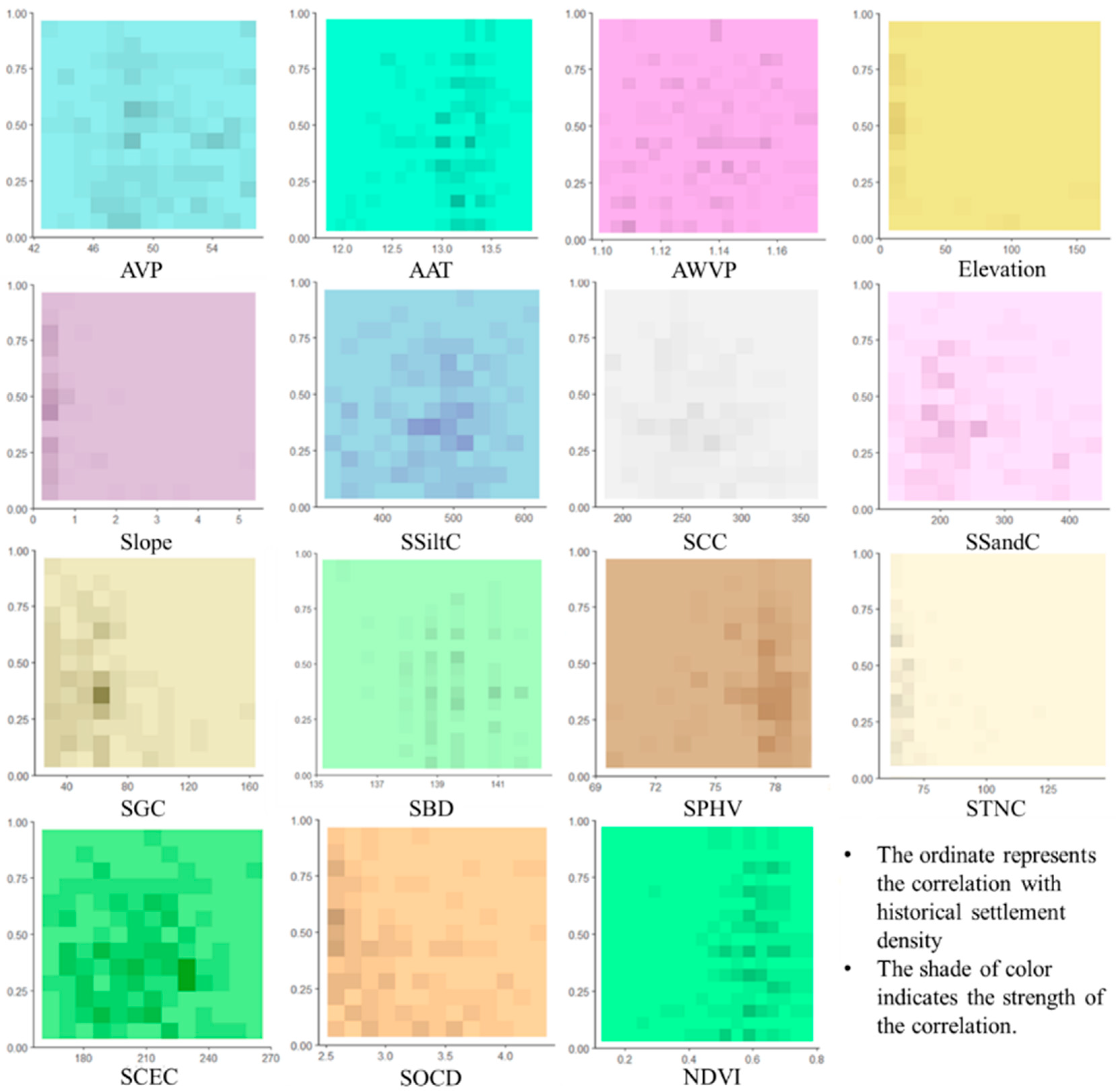
- Correlation analysis: Using SPSS 26.0 statistical analysis software, Pearson correlation analysis is carried out on historical settlement density and natural factors (topographic relief, hydrothermal conditions, soil texture, etc.) to quantify the correlation strength and significance between them. By analyzing the coupling relationship between settlement distribution and natural conditions, the key natural influencing factors driving regional cultivated land development are excavated, laying a foundation for subsequent research on the evolution of human–land relationships and land use history.
3.2.2. Land Reclamation Suitability Model Considering Delta Sedimentary Pattern Changes and Reclamation Priority
4. Results
4.1. Discrimination of Regional Key Factors Based on Historical Settlement Density
4.2. Gridded Allocation of Cultivated Land in the Yellow River Delta Since 1855
5. Discussion
5.1. Comparative Analysis with HYDE3.2 Dataset
5.2. Discussion on Uncertainties of Cultivated Land Gridding Allocation Model
6. Conclusions
- (1)
- The Yellow River Delta is one of the fastest land-forming deltas in the world. This paper uses historical settlement density to select natural factors affecting cultivated land allocation, improves the settlement density method to allocate cultivated land based on this, and modifies the grid distribution results based on historical Yellow River channel distributions. Such an allocation method is applicable in the Yellow River Delta, and the research results accurately demonstrate the historical fact that cultivated land in the Yellow River Delta has experienced stable growth—rapid growth—contraction since 1855.
- (2)
- The main control physical geographic element indicators affecting historical settlement density in the study area are the following: elevation (−); soil pH (+); soil organic carbon density (−); NDVI (+). Each indicator provides key parameter support for subsequent regional human–land relationship evolution and land use history simulation.
- (3)
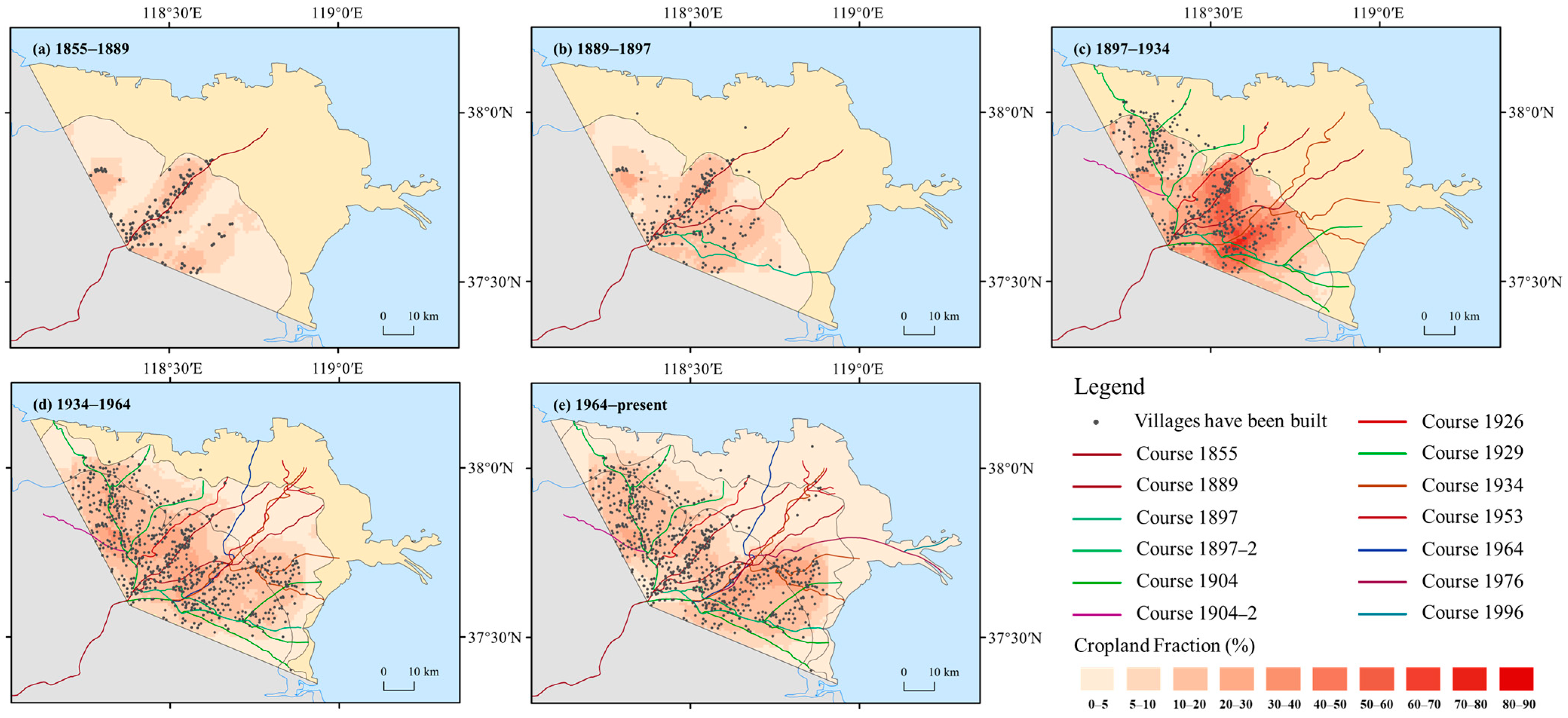
- The quantity of cultivated land in the Yellow River Delta first increased and then decreased since 1885; from 1885 to the early 20th century, reclamation accelerated, with the reclamation rate rising from 5.65% to 23.46% to reach its peak. After 1934, the average reclamation rate declined to 7.68%. Spatially, the reclamation scope has expanded from local sporadic areas along the Yellow River course to the sea since 1855, the intensity decreased after 1934, and a complex pattern of competition between development and protection has emerged since 1964, whose evolution is jointly driven by Yellow River course changes, human activities, and ecological conditions.
- (4)
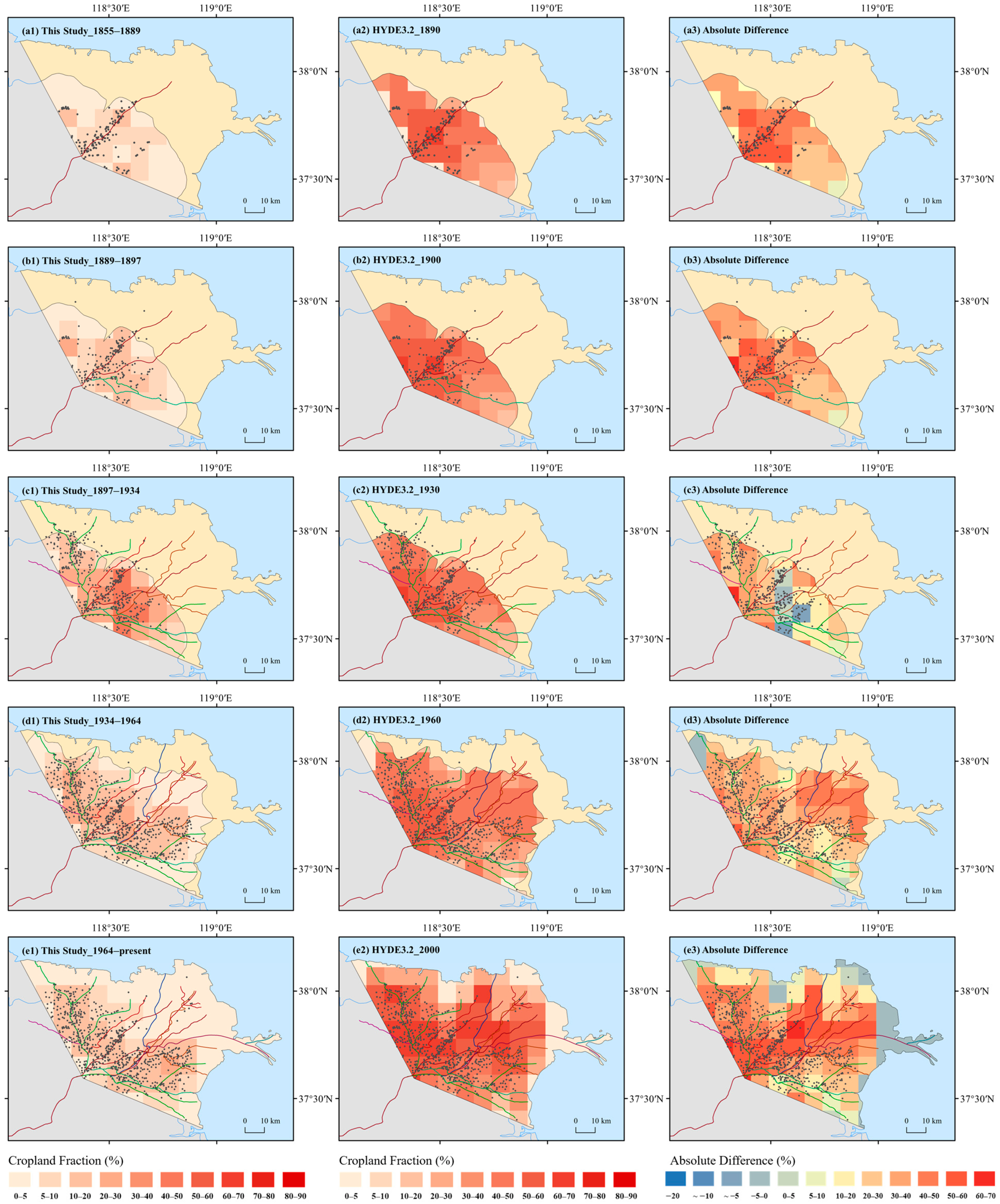
- The differences among the reconstruction results of this study, the HYDE dataset, and regional reconstruction results are mainly due to different cultivated land area data and grid allocation methods. The HYDE dataset does not consider the influence of Yellow River channel changes and coastlines during allocation.
Author Contributions
Funding
Data Availability Statement
Conflicts of Interest
Correction Statement
References
- Barnes, A.D.; Allen, K.; Kreft, H.; Corre, M.D.; Jochum, M.; Veldkamp, E.; Clough, Y.; Daniel, R.; Darras, K.; Denmead, L.H.; et al. Direct and cascading impacts of tropical land-use change on multi-trophic biodiversity. Nat. Ecol. Evol. 2017, 1, 1511–1519. [Google Scholar] [CrossRef]
- Davis, K.F.; Koo, H.I.; Dell’Angelo, J.; D’Odorico, P.; Estes, L.; Kehoe, L.J.; Kharratzadeh, M.; Kuemmerle, T.; Machava, D.; Pais, A.d.J.R.; et al. Tropical forest loss enhanced by large-scale land acquisitions. Nat. Geosci. 2020, 13, 482–488. [Google Scholar] [CrossRef]
- van Vliet, J. Direct and indirect loss of natural area from urban expansion. Nat. Sustain. 2019, 2, 755–763. [Google Scholar] [CrossRef]
- Tubiello, F.N.; Salvatore, M.; Ferrara, A.F.; House, J.; Federici, S.; Rossi, S.; Biancalani, R.; Condor Golec, R.D.; Jacobs, H.; Flammini, A.; et al. The Contribution of Agriculture, Forestry and other Land Use activities to Global Warming, 1990–2012. Glob. Change Biol. 2015, 21, 2655–2660. [Google Scholar] [CrossRef] [PubMed]
- Alexander, P.; Rounsevell, M.D.A.; Dislich, C.; Dodson, J.R.; Engström, K.; Moran, D. Drivers for global agricultural land use change: The nexus of diet, population, yield and bioenergy. Glob. Environ. Change 2015, 35, 138–147. [Google Scholar] [CrossRef]
- Turner, B.L.; Clark, W.C.; Kates, R.W.; Richards, J.F.; Mathews, J.T.; Meyer, W.B. The Earth as Transformed by Human Action: Global and Regional Changes in the Biosphere over the Past 300 Years; Cambridge University Press: Cambridge, UK, 1990. [Google Scholar]
- Goldewijk, K.; Battjes, J.J. A Hundred Year (1890–1990) Database for Integrated Environmental Assessments; National institute of public health and the environment (RIVM): Bilthoven, The Netherlands, 1997. [Google Scholar]
- Goldewijk, K.K.; Beusen, A.; van Drecht, G.; de Vos, M. The HYDE 3.1 spatially explicit database of human-induced global land-use change over the past 12,000 years. Glob. Ecol. Biogeogr. 2011, 20, 73–86. [Google Scholar] [CrossRef]
- Goldewijk, K.K.; Beusen, A.; Doelman, J.; Stehfest, E. Anthropogenic land use estimates for the Holocene—HYDE 3.2. Earth Syst. Sci. Data 2017, 9, 927–953. [Google Scholar] [CrossRef]
- Chini, L.; Hurtt, G.; Sahajpal, R.; Frolking, S.; Goldewijk, K.K.; Sitch, S.; Ganzenmüller, R.; Ma, L.; Ott, L.; Pongratz, J.; et al. Land-use harmonization datasets for annual global carbon budgets. Earth Syst. Sci. Data 2021, 13, 4175–4189. [Google Scholar] [CrossRef]
- Ramankutty, N.; Foley, J.A. Estimating historical changes in global land cover: Croplands from 1700 to 1992. Glob. Biogeochem. Cycles 1999, 13, 997–1027. [Google Scholar] [CrossRef]
- Ramankutty, N.; Foley, J. ISLSCP II Historical Croplands Cover, 1700–1992; NASA: Washington, DC, USA, 2010. [Google Scholar]
- Pongratz, J.; Reick, C.; Raddatz, T.; Claussen, M. A reconstruction of global agricultural areas and land cover for the last millennium. Glob. Biogeochem. Cycles 2008, 22, GB3018. [Google Scholar] [CrossRef]
- Kaplan, J.O.; Krumhardt, K.; Ellis, E.C.; Ruddiman, W.F.; Lemmen, C.; Goldewijk, K.K. Holocene carbon emissions as a result of anthropogenic land cover change. Holocene 2011, 21, 775–791. [Google Scholar] [CrossRef]
- Chen, H.; Wang, X.; Lu, H.; Balen, R.V. Anthropogenic impacts on Holocene fluvial dynamics in the Chinese Loess Plateau, an evaluation based on landscape evolution modeling. Geomorphology 2021, 392, 107935. [Google Scholar] [CrossRef]
- Sterling, S.M.; Ducharne, A.; Polcher, J. The impact of global land-cover change on the terrestrial water cycle. Nat. Clim. Change 2013, 3, 385–390. [Google Scholar] [CrossRef]
- Chakraborty, T.C.; Qian, Y. Urbanization exacerbates continental- to regional-scale warming. One Earth 2024, 7, 1387–1401. [Google Scholar] [CrossRef]
- He, C.; Liu, Z.; Wu, J.; Pan, X.; Fang, Z.; Li, J.; Bryan, B.A. Future global urban water scarcity and potential solutions. Nat. Commun. 2021, 12, 4667. [Google Scholar] [CrossRef]
- Li, S.; He, F.; Liu, X.; Hua, L. Historical land use reconstruction for South Asia: Current understanding, challenges, and solutions. Earth-Sci. Rev. 2023, 238, 104350. [Google Scholar] [CrossRef]
- He, F.; Li, S.; Yang, F.; Li, M. Evaluating the accuracy of Chinese pasture data in global historical land use datasets. Sci. China Earth Sci. 2018, 61, 1685–1696. [Google Scholar] [CrossRef]
- Fang, X.; Ye, Y.; Zeng, Z. Interaction of extreme climate event—Cultivation—Policy management. Sci. China Earth Sci. 2006, 36, 680–688. (In Chinese) [Google Scholar]
- Fang, X.; Zhao, W.; Zhang, C.; Zhang, D.; Wei, X.; Qiu, W.; Ye, Y. Methodology for credibility assessment of historical global LUCC datasets. Sci. China Earth Sci. 2020, 63, 1013–1025. [Google Scholar] [CrossRef]
- Yang, F.; He, F.; Li, S.; Li, M.; Wu, P. A new estimation of carbon emissions from land use and land cover change in China over the past 300 years. Sci. Total Environ. 2023, 863, 160963. [Google Scholar] [CrossRef] [PubMed]
- Zhang, X.; Wang, F.; Lu, W.; Li, S.; Zheng, J. Gridded reconstruction of the population in the traditional cultivated region of China from 1776 to 1953. Sci. China Earth Sci. 2021, 65, 365–378. [Google Scholar] [CrossRef]
- Gaillard, M.-J. LandCover6k: Global anthropogenic land-cover change and its role in past climate. Past. Glob. Change Mag. 2015, 23, 38–39. [Google Scholar] [CrossRef]
- Jia, R.; Fang, X.; Yang, Y.; Yokozawa, M.; Ye, Y. A 28-time-point cropland area change dataset in Northeast China from 1000 to 2020. Earth Syst. Sci. Data 2024, 16, 4971–4994. [Google Scholar] [CrossRef]
- Wu, Z.; Fang, X.; Ye, Y. A Settlement Density Based Allocation Method for Historical Cropland Cover: A Case Study of Jilin Province, China. Land 2022, 11, 1374. [Google Scholar] [CrossRef]
- Zhang, L.; Liu, J. Reconstruction of cropland spatial patterns of the Manas River Basin of Xinjiang in the late Qing and Republican period. Resour. Sci. 2020, 42, 1428–1437. [Google Scholar] [CrossRef]
- He, F.; Yang, F.; Zhao, C.; Li, S.; Li, M. Spatially explicit reconstruction of cropland cover for China over the past millennium. Sci. Sin. (Terrae) 2023, 53, 115–131. [Google Scholar] [CrossRef]
- Wang, Y.; Tao, J.; Liu, F.; Zhang, Y.; Chen, Q. Reconstruction of cropland spatial pattern in 1830 in the middle reaches of Yarlung Zangbo River Valley. Geogr. Res. 2015, 34, 2355–2367. [Google Scholar]
- Li, J.; Ye, Y.; Wei, X. Reconstruction of cropland change in the southern area of the Daqing River Basin over the past 300 years. Prog. Geogr. 2019, 38, 883–895. [Google Scholar]
- Cui, B.-L.; Li, X.-Y. Coastline change of the Yellow River estuary and its response to the sediment and runoff (1976–2005). Geomorphology 2011, 127, 32–40. [Google Scholar] [CrossRef]
- Chang, G.H.; Liu, Q.S. Analysis on spatio-temporal feature of coastline change in the Yellow River Estuary and its relation with runoff and sand-transportation. Geogr. Res. 2004, 23, 339–346. (In Chinese) [Google Scholar]
- Cui, B.L.; Li, X.Y. The impact of hydrological characteristics of the Yellow River coastline changes in the Yellow River Delta. J. Nat. Resour. 2006, 21, 957–964. (In Chinese) [Google Scholar]
- Bi, N.S.; Wang, H.J.; Wu, X.; Saito, Y.; Xu, C.L.; Yang, Z.S. Phase change in evolution of the modern Huanghe (Yellow River) Delta: Process, pattern, and mechanisms. Mar. Geol. 2021, 437, 106516. [Google Scholar] [CrossRef]
- Ye, Y.; Liu, Y.T.; Gao, S.Q.; Lou, L.; Zhang, X.P.; Wang, F.H. The Influence of Historical River System Changes on Settlement Distribution and Implications for Cropland Gridding in the Yellow River Delta. Land 2025, 14, 812. [Google Scholar] [CrossRef]
- Liu, Y.T.; Ye, Y.; Jiang, C.; Jiang, J.F.; Wang, F.H.; Li, J.; Zhang, X.P. Dynamics of Rural Settlement Patterns in the Yellow River Delta in Response to River Diversion and Avulsion Since 1855. Rural. Landsc. Soc. Environ. Hist. 2024, 11, 2. [Google Scholar] [CrossRef]
- Zhang, X.J.; Wang, G.Q.; Xue, B.L.; Zhang, M.X.; Tan, Z.X. Dynamic landscapes and the driving forces in the Yellow River Delta wetland region in the past four decades. Sci. Total Environ. 2021, 787, 147644. [Google Scholar] [CrossRef]
- Sun, Z.G.; Mou, X.J.; Chen, X.B.; Wang, L.L. Actualities, problems and suggestions of wetland protection and restoration in the Yellow River Delta. Wetl. Sci. 2011, 9, 107–115. [Google Scholar]
- Yang, C.; Lv, D.T.; Jiang, S.Y.; Lin, H.; Sun, J.Q.; Li, K.J.; Sun, J. Soil salinity regulation of soil microbial carbon metabolic function in the Yellow River Delta, China. Sci. Total Environ. 2021, 790, 148258. [Google Scholar] [CrossRef]
- Liu, J.K.; Engel, B.A.; Wang, Y.; Zhang, G.F.; Zhang, Z.M.; Zhang, M.X. Multi-scale analysis of hydrological connectivity and plant response in the Yellow River Delta. Sci. Total Environ. 2020, 702, 134889. [Google Scholar] [CrossRef]
- Wang, Y.X.; Wu, C.S.; Zhao, Z.H.; Yu, B.W.; Liu, G.H. Assessing spatiotemporal heterogeneity of coastal organic nonpoint source pollution via soil erosion in Yellow River Delta, China. Ecol. Indic. 2024, 166, 112519. [Google Scholar] [CrossRef]
- Man, Y.; Du, J.Z.; Lian, Z.M.; Wang, Q.; Cui, B.S. A framework to quantitatively assess the influence of land use and land cover on coastal wetland hydrological connectivity from a landscape resistance perspective. Sci. Total Environ. 2024, 992, 171140. [Google Scholar] [CrossRef]
- Administration Bureau of the Yellow River Estuary, the Yellow River Conservancy Commission. Annals of the Yellow River in Dongying City; Qilu Publishing House: Jinan, China, 1995. [Google Scholar]
- Wang, J. Study on the characteristics and formation mechanism of groundwater chemical composition in the Yellow River Delta. Master’s Thesis, Ocean University of China, Qingdao, China, 2012. [Google Scholar]
- Kong, D.X.; Miao, C.Y.; Borthwick, A.G.L.; Duan, Q.Y.; Liu, H.; Sun, Q.H.; Ye, A.Z.; Di, Z.H.; Gong, W. Evolution of the Yellow River Delta and its relationship with runoff and sediment load from 1983 to 2011. J. Hydrol. 2015, 520, 62–73. [Google Scholar] [CrossRef]
- Zhang, X.G.; Wang, S.C.; Zou, Y.L. Historical and Physical Geography of China; Science Press: Beijing, China, 2013. [Google Scholar]
- Ye, Y.; Wei, X.Q.; Li, F.; Fang, X.Q. Reconstruction of cropland cover changes in the Shandong Province over the past 300 years. Sci. Rep. 2015, 5, 13642. [Google Scholar] [CrossRef]
- Zeng, Z.Z.; Fang, X.Q.; Ye, Y. The Process of Land Cultivation Based on Settlement Names in Jilin Province in the Past 300 Years. Acta Geogr. Sin. 2011, 66, 985–993. (In Chinese) [Google Scholar]
- Jia, D.; Li, Y.K.; Fang, X.Q. Complexity of factors influencing the spatiotemporal distribution of archaeological settlements in northeast China over the past millennium. Quat. Res. 2018, 89, 413–424. [Google Scholar] [CrossRef]
- Zhang, C.P.; Fang, X.Q.; Ye, Y.; Tang, C.C.; Wu, Z.L.; Zheng, X.; Zhang, D.Y.; Jiang, C.; Li, J.; Li, Y.K.; et al. A spatially explicit reconstruction of cropland cover in China around 1850 C.E. employing new land suitability based gridded allocation algorithm. Quat. Int. 2022, 641, 62–73. [Google Scholar] [CrossRef]
- Zhang, C. Development of a Gridded Allocation Algorithm of Historical Cropland Derived from the Physiogeographic Factors—A Case Study of China; Beijing Normal University: Beijing, China, 2021. (In Chinese) [Google Scholar]
- Office of Zhanghua County Place Name Committee. Gazetteer of Place Names in Zhanghua County, Shandong Province; Ocean Press: Beijing, China, 1988. (In Chinese) [Google Scholar]
- Editorial Committee of Local Chronicles of Hekou District, Dongying City. Annals of Hekou District; Zhonghua Book Company: Beijing, China, 2002. (In Chinese) [Google Scholar]


| Type | Data Name | Unit | Resolution | Data Source |
|---|---|---|---|---|
| Meteorological Elements | Annual Average Precipitation | mm | 1 km × 1 km | WorldClim multi-year averages for 1970–2000 (https://www.worldclim.org/, accessed on 25 June 2021) |
| Annual Average Temperature | °C | 1 km × 1 km | ||
| Average Water Vapor Pressure | Pa | 1 km × 1 km | ||
| Topographic Elements | Elevation | m | 90 m × 90 m | Derived from the SRTM-DEM product mosaicked by USGS-SRTM released DEM (v4.1) data (http://srtm.csi.cgiar.org/, accessed on 25 June 2021) |
| Slope | ° | 90 m × 90 m | ||
| Soil Elements | Soil silt content | % | 250 m × 250 m | Calculated by summing and averaging the data of each factor layer by layer (5 layers from the surface to 60 cm underground) in SoilGrids (www.soilgrids.org, accessed on 25 June 2021) |
| Soil clay content | % | 250 m × 250 m | ||
| Soil sand content | % | 250 m × 250 m | ||
| Soil gravel content | % | 250 m × 250 m | ||
| Soil bulk density | kg/m3 | 250 m × 250 m | ||
| Soil PH value | — | 250 m × 250 m | ||
| Soil total nitrogen content | % | 250 m × 250 m | ||
| Soil cation exchange capacity | cmol/kg | 250 m × 250 m | ||
| Soil organic carbon density | ppm | 250 m × 250 m | ||
| Other Elements | NDVI | — | 10 km × 10 km | Obtained by the MVC method from the 1981–2015 biweekly data of the GIMMS product released by NASA |
| Type | Correlation Coefficient | Sig. (2-Tailed) | Fixed Variable | Partial Correlation Coefficient After Fixing Variables | Sig. (2-Tailed) |
|---|---|---|---|---|---|
| AVP | −0.113 | 0.101 | AWVP | 0.280 | 0.001 |
| AAT | 0.264 ** | 0.000 | NDVI | 0.199 | 0.020 |
| AWVP | 0.111 | 0.108 | AVP | 0.170 | 0.047 |
| Elevation | −0.355 ** | 0.000 | Slope, NDVI | −0.06 | 0.489 |
| Slope | −0.354 ** | 0.000 | Elevation, NDVI, SSiltC | 0.092 | 0.293 |
| SSiltC | 0.103 | 0.152 | SSandC | 0.243 | 0.004 |
| SCC | 0.076 | 0.290 | SSandC | −0.254 | 0.004 |
| SSandC | −0.123 | 0.085 | AAT, SsiltC, SCC | −0.072 | 0.407 |
| SGC | −0.105 | 0.142 | SsiltC, SSandC | −0.325 | 0.000 |
| SBD | −0.121 | 0.900 | — | — | — |
| SPHV | 0.254 ** | 0.000 | SCEC, AAT | −0.252 | 0.003 |
| STNC | −0.01 | 0.988 | SPHV, NDVI | −0.294 | 0.001 |
| SCEC | −0.144 * | 0.45 | SPHV, NDVI | 0.075 | 0.386 |
| SOCD | 0.023 | 0.746 | AVP, AAT | −0.438 | 0.000 |
| NDVI | −0.048 | 0.486 | AVP, AAT, SsiltC, SCC | 0.093 | 0.285 |
| Period | The Interval of the Cropland Fraction in This Study (%) | Average Cropland Fraction (%) | ||||||||||
|---|---|---|---|---|---|---|---|---|---|---|---|---|
| 0–1 | 1–5 | 5–10 | 10–20 | 20–30 | 30–40 | 40–50 | 50–60 | 60–70 | 70–80 | 80–90 | ||
| 1855–1889 | 7.87 | 46.79 | 30.06 | 15.28 | — | — | — | — | — | — | — | 5.65 |
| 1889–1897 | 1.29 | 39.67 | 36.09 | 40.96 | 3.17 | — | — | — | — | — | — | 8.57 |
| 1897–1934 | 1.74 | 2.58 | 16.86 | 29.63 | 19.51 | 11.22 | 11.78 | 4.93 | 1.36 | 0.38 | — | 23.46 |
| 1934–1964 | 0.11 | 24.56 | 24.85 | 38.43 | 11.57 | 0.47 | — | — | — | — | — | 11.40 |
| 1964–present | 0.07 | 52.12 | 18.18 | 23.52 | 6.11 | — | — | — | — | — | — | 7.68 |
Disclaimer/Publisher’s Note: The statements, opinions and data contained in all publications are solely those of the individual author(s) and contributor(s) and not of MDPI and/or the editor(s). MDPI and/or the editor(s) disclaim responsibility for any injury to people or property resulting from any ideas, methods, instructions or products referred to in the content. |
© 2025 by the authors. Licensee MDPI, Basel, Switzerland. This article is an open access article distributed under the terms and conditions of the Creative Commons Attribution (CC BY) license (https://creativecommons.org/licenses/by/4.0/).
Share and Cite
Lou, L.; Ye, Y.; Liu, Y. Reconstruction of Cultivated Land Dynamics in the Yellow River Delta Basin Since 1855. Land 2025, 14, 1826. https://doi.org/10.3390/land14091826
Lou L, Ye Y, Liu Y. Reconstruction of Cultivated Land Dynamics in the Yellow River Delta Basin Since 1855. Land. 2025; 14(9):1826. https://doi.org/10.3390/land14091826
Chicago/Turabian StyleLou, Lin, Yu Ye, and Yuting Liu. 2025. "Reconstruction of Cultivated Land Dynamics in the Yellow River Delta Basin Since 1855" Land 14, no. 9: 1826. https://doi.org/10.3390/land14091826
APA StyleLou, L., Ye, Y., & Liu, Y. (2025). Reconstruction of Cultivated Land Dynamics in the Yellow River Delta Basin Since 1855. Land, 14(9), 1826. https://doi.org/10.3390/land14091826


