


Dynamic Assessment of Street Environmental Quality Using Time-Series Street View Imagery Within Daily Intervals

Abstract
1. Introduction
2. Related Work
2.1. Analyzing Street View Imagery Through Deep Learning
2.2. Human Perception of Urban Street Environments
2.3. Challenges in Analyzing SVI Using Time-Series Approaches
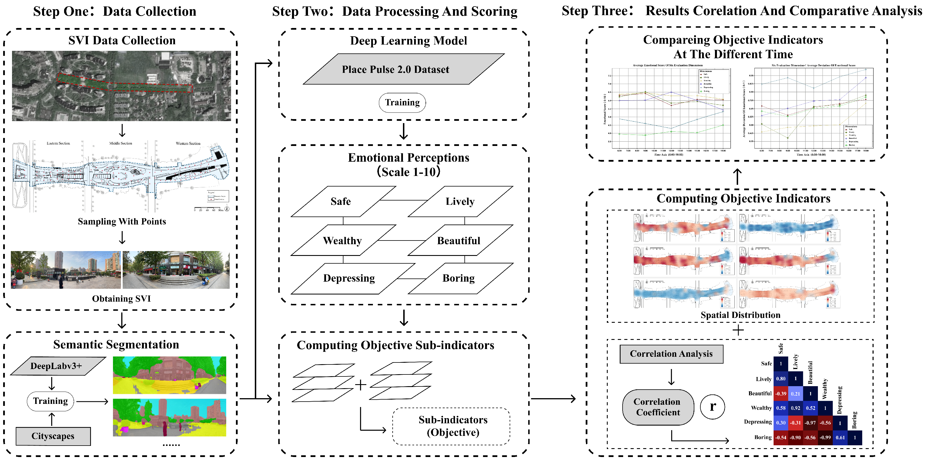
3. Methodology
3.1. Research Framework
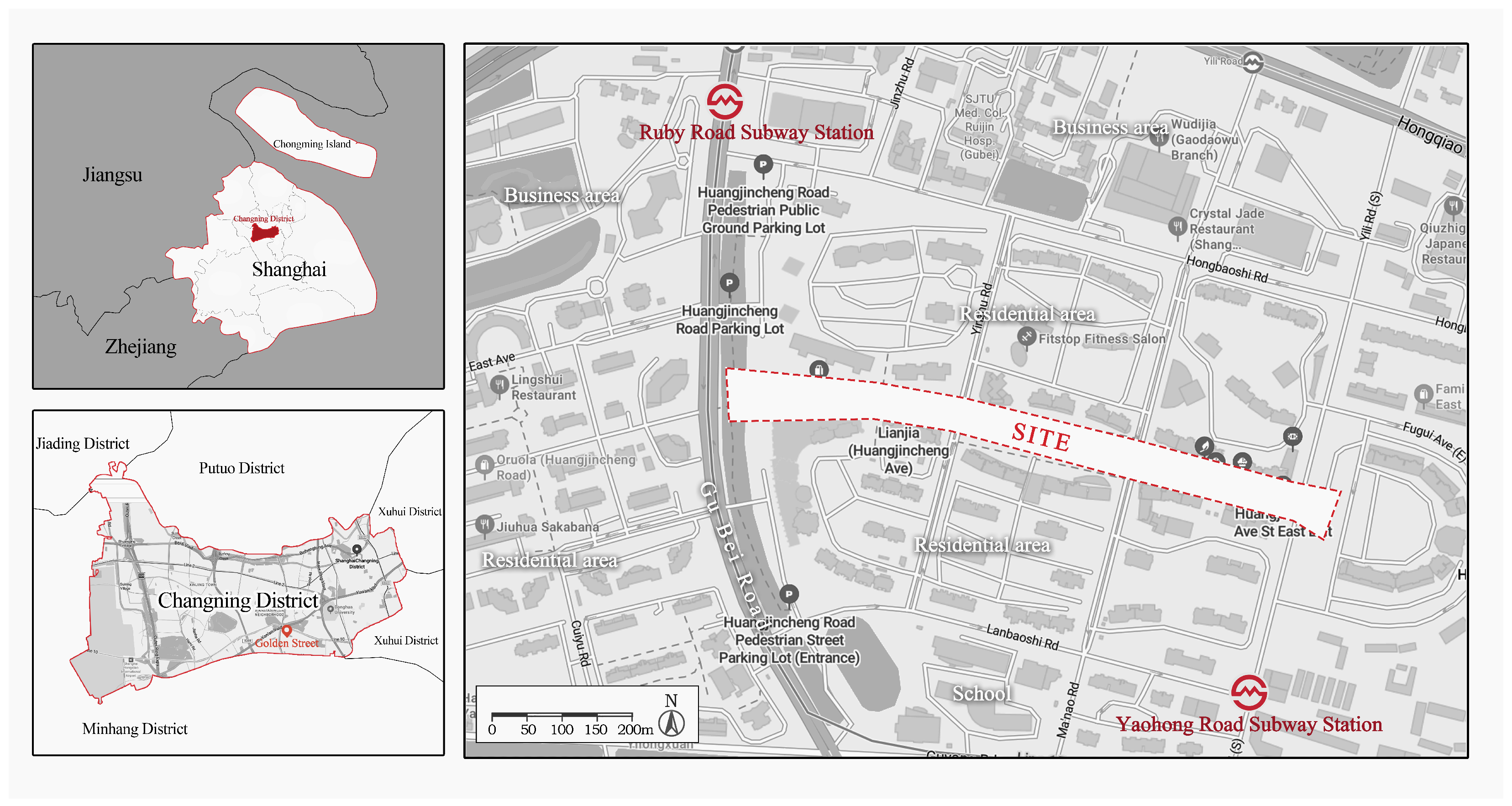
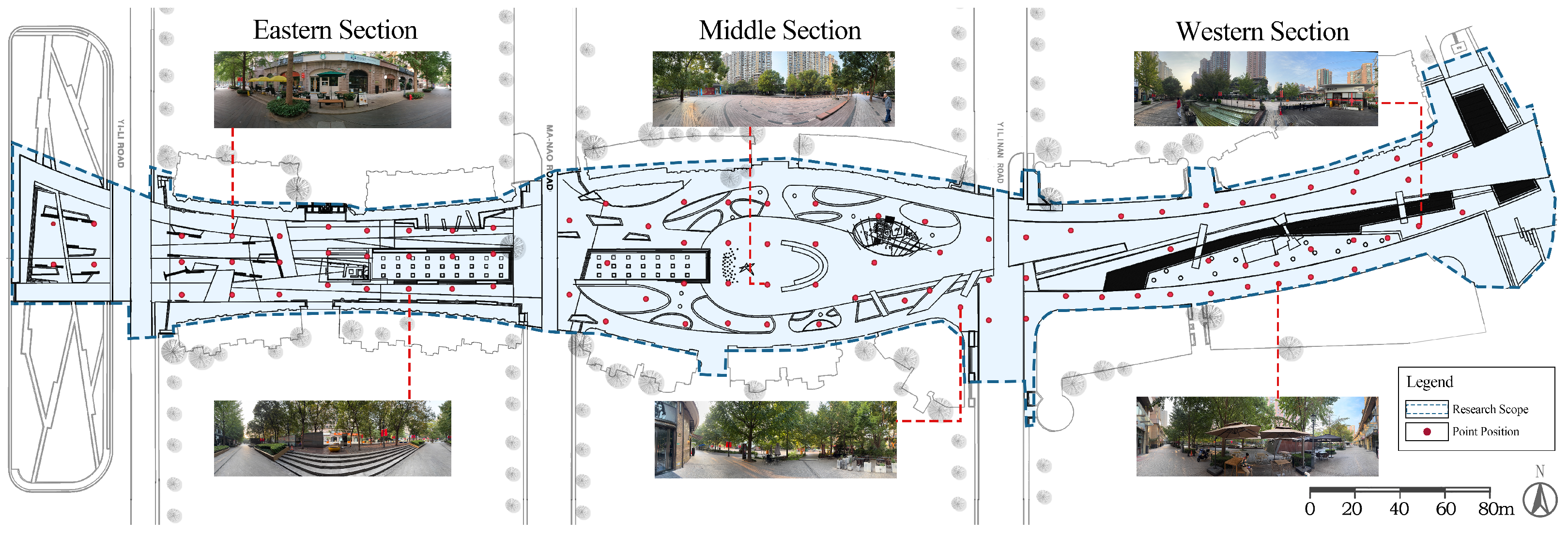
3.2. Study Area
3.3. MIT Place Pulse 2.0 Dataset and Perceptual Indicators
3.4. Data Collection
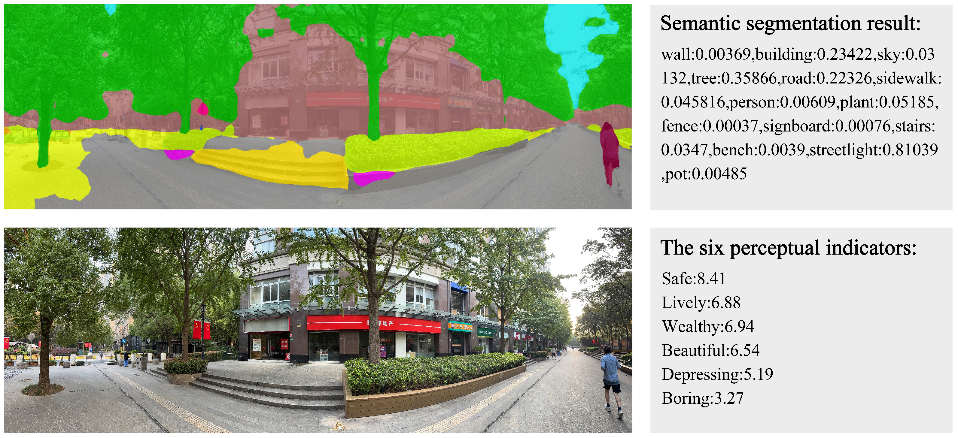
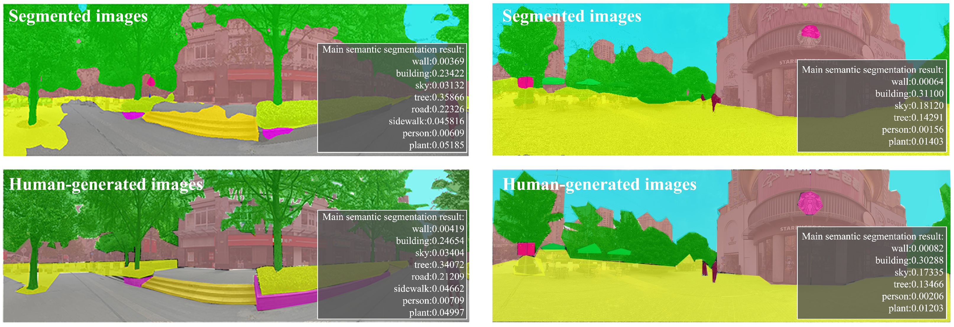
3.5. Deep Learning Model for Assessing Street Environmental Quality
3.6. Spatial and Temporal Analytical Approaches
4. Results
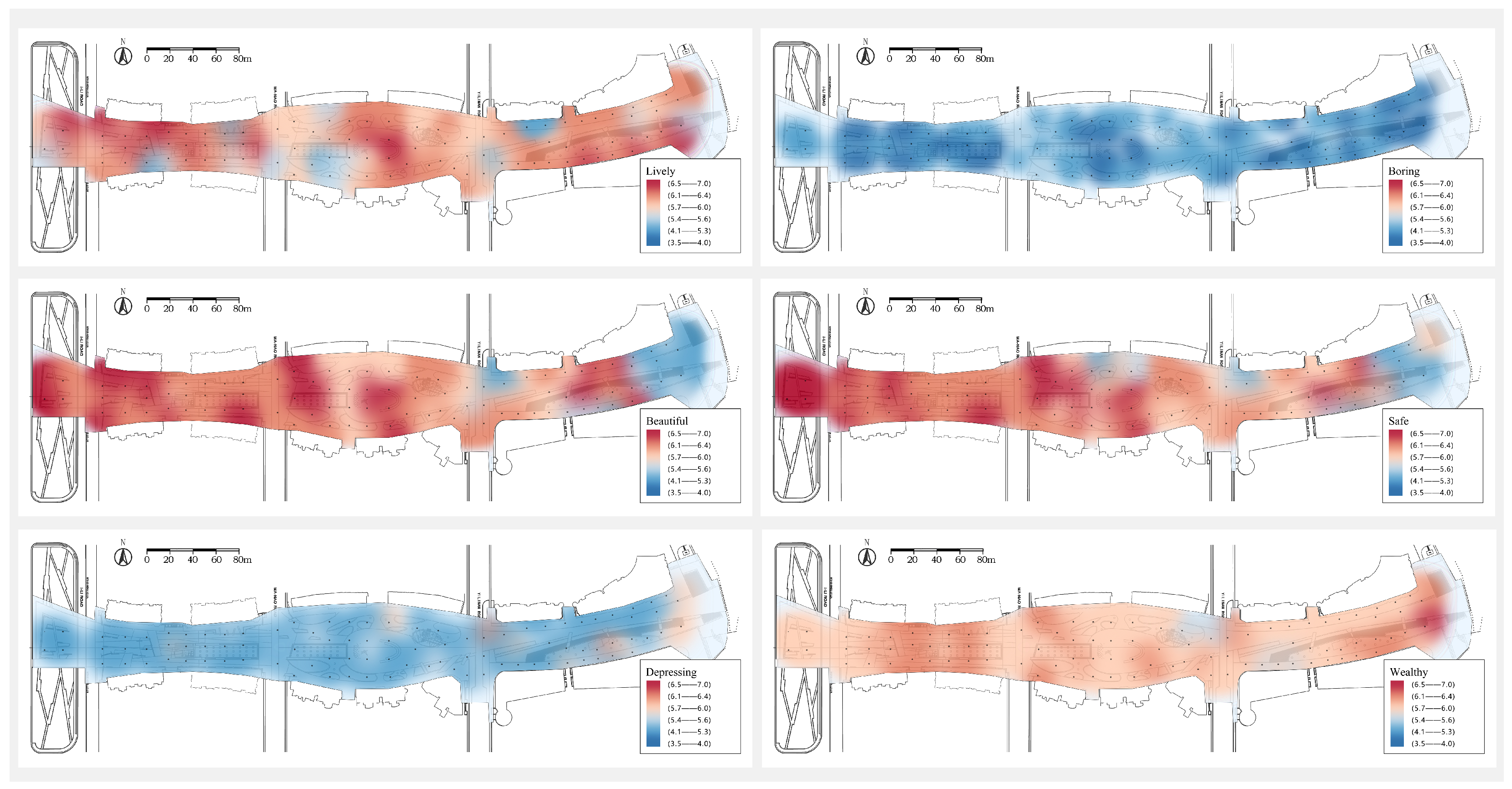
4.1. Spatial Variation in Visual Environmental Quality on Golden Street
4.2. Spatio-Temporal Variation in Street Environmental Quality
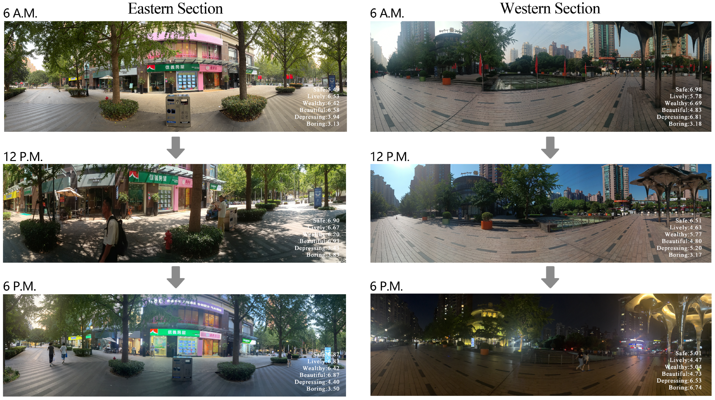
4.2.1. Temporal Variations Across the Entire Street
4.2.2. Spatial Differences in Temporal Variations Among Street Sections
5. Discussion
5.1. Spatio-Temporal Variation in Human Perceptions on Golden Street
5.2. Implications for High-Quality Living Streets
5.3. Limitations and Future Research Directions
5.3.1. Limitations of the Place Pulse 2.0 Dataset
5.3.2. Contextual Generalizability
5.3.3. Potential Future Analyses
6. Conclusions
Author Contributions
Funding
Data Availability Statement
Conflicts of Interest
References
- Schneider, A.; Friedl, M.A.; Potere, D. Mapping global urban areas using MODIS 500-m data: New methods and datasets based on ‘urban ecoregions’. Remote Sens. Environ. 2010, 114, 1733–1746. [Google Scholar] [CrossRef]
- Lu, Y.; Sarkar, C.; Xiao, Y. The effect of street-level greenery on walking behavior: Evidence from Hong Kong. Soc. Sci. Med. 2018, 208, 41–49. [Google Scholar] [CrossRef]
- Saelens, B.E.; Handy, S.L. Built environment correlates of walking: A review. Med. Sci. Sport. Exerc. 2008, 40, S550. [Google Scholar] [CrossRef]
- Gutman, R. The social function of the built environment. In The Mutual Interaction of People and Their Built Environment; De Gruyter Mouton: Berlin, Germany; New York, NY, USA, 1976; p. 37. [Google Scholar]
- Allocated, L.; Core, C. Streets as Public Spaces and Drivers of Urban Prosperity; UN-HABITAT: Nairobi, Kenya, 2013; p. 108. [Google Scholar]
- Wang, J.; Chow, Y.S.; Biljecki, F. Insights in a city through the eyes of Airbnb reviews: Sensing urban characteristics from homestay guest experiences. Cities 2023, 140, 104399. [Google Scholar] [CrossRef]
- Liu, L.; Silva, E.A.; Wu, C.; Wang, H. A machine learning-based method for the large-scale evaluation of the qualities of the urban environment. Comput. Environ. Urban Syst. 2017, 65, 113–125. [Google Scholar] [CrossRef]
- Biljecki, F.; Ito, K. Street view imagery in urban analytics and GIS: A review. Landsc. Urban Plan. 2021, 215, 104217. [Google Scholar] [CrossRef]
- Jeon, J.; Woo, A. Deep learning analysis of street panorama images to evaluate the streetscape walkability of neighborhoods for subsidized families in Seoul, Korea. Landsc. Urban Plan. 2023, 230, 104631. [Google Scholar] [CrossRef]
- Huang, Z.; Du, X. Assessment and determinants of residential satisfaction with public housing in Hangzhou, China. Habitat Int. 2015, 47, 218–230. [Google Scholar] [CrossRef]
- Zhang, F.; Zhou, B.; Liu, L.; Liu, Y.; Fung, H.H.; Lin, H.; Ratti, C. Measuring human perceptions of a large-scale urban region using machine learning. Landsc. Urban Plan. 2018, 180, 148–160. [Google Scholar] [CrossRef]
- Liu, Z.; Ma, L. Residential experiences and satisfaction of public housing renters in Beijing, China: A before-after relocation assessment. Cities 2021, 113, 103148. [Google Scholar] [CrossRef]
- An, D.; Liu, Y.; Huang, Y. The Influence of Street Components on Age Diversity: A Case Study on a Living Street in Shanghai. Sustainability 2023, 15, 10493. [Google Scholar] [CrossRef]
- Wang, Z.; Ito, K.; Biljecki, F. Assessing the equity and evolution of urban visual perceptual quality with time series street view imagery. Cities 2024, 145, 104704. [Google Scholar] [CrossRef]
- Kang, Y.; Zhang, F.; Gao, S.; Lin, H.; Liu, Y. A review of urban physical environment sensing using street view imagery in public health studies. Ann. GIS 2020, 26, 261–275. [Google Scholar] [CrossRef]
- Goel, R.; Garcia, L.M.; Goodman, A.; Johnson, R.; Aldred, R.; Murugesan, M.; Brage, S.; Bhalla, K.; Woodcock, J. Estimating city-level travel patterns using street imagery: A case study of using Google Street View in Britain. PLoS ONE 2018, 13, e0196521. [Google Scholar] [CrossRef]
- Chen, S.; Biljecki, F. Automatic assessment of public open spaces using street view imagery. Cities 2023, 137, 104329. [Google Scholar] [CrossRef]
- Helbich, M.; Yao, Y.; Liu, Y.; Zhang, J.; Liu, P.; Wang, R. Using deep learning to examine street view green and blue spaces and their associations with geriatric depression in Beijing, China. Environ. Int. 2019, 126, 107–117. [Google Scholar] [CrossRef] [PubMed]
- Dubey, A.; Naik, N.; Parikh, D.; Raskar, R.; Hidalgo, C.A. Deep learning the city: Quantifying urban perception at a global scale. In Proceedings of the Computer Vision–ECCV 2016: 14th European Conference, Amsterdam, The Netherlands, 11–14 October 2016; Proceedings, Part I 14. Springer: Berlin/Heidelberg, Germany, 2016; pp. 196–212. [Google Scholar]
- Dadvand, P.; Bartoll, X.; Basagaña, X.; Dalmau-Bueno, A.; Martinez, D.; Ambros, A.; Cirach, M.; Triguero-Mas, M.; Gascon, M.; Borrell, C.; et al. Green spaces and general health: Roles of mental health status, social support, and physical activity. Environ. Int. 2016, 91, 161–167. [Google Scholar] [CrossRef] [PubMed]
- Wei, J.; Yue, W.; Li, M.; Gao, J. Mapping human perception of urban landscape from street-view images: A deep-learning approach. Int. J. Appl. Earth Obs. Geoinf. 2022, 112, 102886. [Google Scholar] [CrossRef]
- Zhang, F.; Fan, Z.; Kang, Y.; Hu, Y.; Ratti, C. “Perception bias”: Deciphering a mismatch between urban crime and perception of safety. Landsc. Urban Plan. 2021, 207, 104003. [Google Scholar] [CrossRef]
- Long, Y.; Ye, Y. Measuring human-scale urban form and its performance. Landsc. Urban Plan. 2019, 191, 103612. [Google Scholar] [CrossRef] [PubMed]
- Nasar, J.L. Perception, cognition, and evaluation of urban places. In Public Places and Spaces; Springer: Berlin/Heidelberg, Germany, 1989; pp. 31–56. [Google Scholar]
- Bonaiuto, M.; Fornara, F. Residential satisfaction and perceived urban quality. Encycl. Appl. Psychol. 2004, 3, 267–272. [Google Scholar]
- Smardon, R.C. Perception and aesthetics of the urban environment: Review of the role of vegetation. Landsc. Urban Plan. 1988, 15, 85–106. [Google Scholar] [CrossRef]
- Liu, K.; Zhang, L.; Tsou, S.; Wang, L.; Hu, Y.; Yang, K. Exploring the Complex Association Between Urban Built Environment, Sociodemographic Characteristics and Crime: Evidence from Washington, DC. Land 2024, 13, 1886. [Google Scholar] [CrossRef]
- Gebru, T.; Krause, J.; Wang, Y.; Chen, D.; Deng, J.; Aiden, E.L.; Li, F. Using deep learning and Google Street View to estimate the demographic makeup of neighborhoods across the United States. Proc. Natl. Acad. Sci. USA 2017, 114, 13108–13113. [Google Scholar] [CrossRef]
- Li, M.; Sheng, H.; Irvin, J.; Chung, H.; Ying, A.; Sun, T.; Ng, A.Y.; Rodriguez, D.A. Marked crosswalks in US transit-oriented station areas, 2007–2020: A computer vision approach using street view imagery. Environ. Plan. B Urban Anal. City Sci. 2023, 50, 350–369. [Google Scholar] [CrossRef]
- Liang, X.; Zhao, T.; Biljecki, F. Revealing spatio-temporal evolution of urban visual environments with street view imagery. Landsc. Urban Plan. 2023, 237, 104802. [Google Scholar] [CrossRef]
- Rui, J. Measuring streetscape perceptions from driveways and sidewalks to inform pedestrian-oriented street renewal in Düsseldorf. Cities 2023, 141, 104472. [Google Scholar] [CrossRef]
- Li, X.; Zhang, C.; Li, W.; Ricard, R.; Meng, Q.; Zhang, W. Assessing street-level urban greenery using Google Street View and a modified green view index. Urban For. Urban Green. 2015, 14, 675–685. [Google Scholar] [CrossRef]
- Naik, N.; Philipoom, J.; Raskar, R.; Hidalgo, C. Streetscore-predicting the perceived safety of one million streetscapes. In Proceedings of the IEEE Conference on Computer Vision and Pattern Recognition Workshops, Columbus, OH, USA, 23–28 June 2014; pp. 779–785. [Google Scholar]
- Bradley, R.A.; Terry, M.E. Rank analysis of incomplete block designs: I. The method of paired comparisons. Biometrika 1952, 39, 324–345. [Google Scholar] [CrossRef]
- Alexander, C. A Pattern Language: Towns, Buildings, Construction; Oxford University Press: Oxford, UK, 1977. [Google Scholar]
- Causeur, D.; Husson, F. A 2-dimensional extension of the Bradley–Terry model for paired comparisons. J. Stat. Plan. Inference 2005, 135, 245–259. [Google Scholar] [CrossRef]
- Chen, L.C.; Zhu, Y.; Papandreou, G.; Schroff, F.; Adam, H. Encoder-decoder with atrous separable convolution for semantic image segmentation. In Proceedings of the European Conference on Computer Vision (ECCV), Munich, Germany, 8–14 September 2018; pp. 801–818. [Google Scholar]
- Cordts, M.; Omran, M.; Ramos, S.; Rehfeld, T.; Enzweiler, M.; Benenson, R.; Franke, U.; Roth, S.; Schiele, B. The cityscapes dataset for semantic urban scene understanding. In Proceedings of the IEEE Conference on Computer Vision and Pattern Recognition, Las Vegas, NV, USA, 27–30 June 2016; pp. 3213–3223. [Google Scholar]
- Ren, Z.; Wang, L.; Song, T.; Li, Y.; Zhang, J.; Zhao, F. Enhancing Road Scene Segmentation with an Optimized DeepLabV3+. IEEE Access 2024, 12, 197748–197765. [Google Scholar] [CrossRef]
- Qin, J.; Xu, C.; Ai, Y.; Zhang, H.; Cheng, Y. Research on Semantic Segmentation Algorithm for Autonomous Driving Based on Improved DeepLabv3+. In Artificial Intelligence in China, Proceedings of the International Conference on Artificial Intelligence in China, Wuhan, China, 18–20 November 2023; Springer: Singapore, 2023; pp. 107–117. [Google Scholar]
- Chen, L.C.; Papandreou, G.; Kokkinos, I.; Murphy, K.; Yuille, A.L. Deeplab: Semantic image segmentation with deep convolutional nets, atrous convolution, and fully connected crfs. IEEE Trans. Pattern Anal. Mach. Intell. 2017, 40, 834–848. [Google Scholar] [CrossRef]
- Hadinata, P.N.; Simanta, D.; Eddy, L.; Nagai, K. Crack detection on concrete surfaces using deep encoder-decoder convolutional neural network: A comparison study between U-Net and DeepLabV3+. J. Civ. Eng. Forum 2021, 7, 323–334. [Google Scholar] [CrossRef]
- Liu, Y.; Tian, Y.; Chen, Y.; Liu, F.; Belagiannis, V.; Carneiro, G. Perturbed and strict mean teachers for semi-supervised semantic segmentation. In Proceedings of the IEEE/CVF Conference on Computer Vision and Pattern Recognition, New Orleans, LA, USA, 18–24 June 2022; pp. 4258–4267. [Google Scholar]
- Jiang, B.; Mak, C.N.S.; Zhong, H.; Larsen, L.; Webster, C.J. From broken windows to perceived routine activities: Examining impacts of environmental interventions on perceived safety of urban alleys. Front. Psychol. 2018, 9, 2450. [Google Scholar] [CrossRef]
- Newman, O. Defensible Space: Crime Prevention Through Urban Design; Collier Books: New York, NY, USA, 1973. [Google Scholar]
- Lynch, K. The Image of the City; MIT Press: Cambridge, MA, USA, 1964. [Google Scholar]
- Cozens, P.M.; Saville, G.; Hillier, D. Crime prevention through environmental design (CPTED): A review and modern bibliography. Prop. Manag. 2005, 23, 328–356. [Google Scholar] [CrossRef]
- Nasar, J.L. Visual preferences in urban street scenes: A cross-cultural comparison between Japan and the United States. J. Cross-Cult. Psychol. 1984, 15, 79–93. [Google Scholar] [CrossRef]
- Fuller, M.; Moore, R. An Analysis of Jane Jacobs’s the Death and Life of Great American Cities; Macat Library: London, UK, 2017. [Google Scholar]
- Jansson, M.; Fors, H.; Lindgren, T.; Wiström, B. Perceived personal safety in relation to urban woodland vegetation–A review. Urban For. Urban Green. 2013, 12, 127–133. [Google Scholar] [CrossRef]
- Ristea, A.; Leitner, M.; Resch, B.; Stratmann, J. Applying spatial video geonarratives and physiological measurements to explore perceived safety in Baton Rouge, Louisiana. Int. J. Environ. Res. Public Health 2021, 18, 1284. [Google Scholar] [CrossRef] [PubMed]
- Kang, Y.; Abraham, J.; Ceccato, V.; Duarte, F.; Gao, S.; Ljungqvist, L.; Zhang, F.; Näsman, P.; Ratti, C. Assessing differences in safety perceptions using GeoAI and survey across neighbourhoods in Stockholm, Sweden. Landsc. Urban Plan. 2023, 236, 104768. [Google Scholar] [CrossRef]
- Ma, S.; Wang, B.; Liu, W.; Zhou, H.; Wang, Y.; Li, S. Assessment of street space quality and subjective well-being mismatch and its impact, using multi-source big data. Cities 2024, 147, 104797. [Google Scholar] [CrossRef]
- Chiang, Y.C.; Liu, H.H.; Li, D.; Ho, L.C. Quantification through deep learning of sky view factor and greenery on urban streets during hot and cool seasons. Landsc. Urban Plan. 2023, 232, 104679. [Google Scholar] [CrossRef]
- Han, Y.; Zhong, T.; Yeh, A.G.; Zhong, X.; Chen, M.; Lü, G. Mapping seasonal changes of street greenery using multi-temporal street-view images. Sustain. Cities Soc. 2023, 92, 104498. [Google Scholar] [CrossRef]
- Lian, H.; Li, X.; Zhou, W.; Zhang, J.; Li, H. Pedestrian vitality characteristics in pedestrianized commercial streets-considering temporal, spatial, and built environment factors. Front. Archit. Res. 2025, 14, 630–653. [Google Scholar] [CrossRef]
- Wu, T.; Chen, Z.; Li, S.; Xing, P.; Wei, R.; Meng, X.; Zhao, J.; Wu, Z.; Qiao, R. Decoupling Urban Street Attractiveness: An Ensemble Learning Analysis of Color and Visual Element Contributions. Land 2025, 14, 979. [Google Scholar] [CrossRef]


Disclaimer/Publisher’s Note: The statements, opinions and data contained in all publications are solely those of the individual author(s) and contributor(s) and not of MDPI and/or the editor(s). MDPI and/or the editor(s) disclaim responsibility for any injury to people or property resulting from any ideas, methods, instructions or products referred to in the content. |
© 2025 by the authors. Licensee MDPI, Basel, Switzerland. This article is an open access article distributed under the terms and conditions of the Creative Commons Attribution (CC BY) license (https://creativecommons.org/licenses/by/4.0/).
Share and Cite
Zhang, P.; Liu, Y.; Huang, Y. Dynamic Assessment of Street Environmental Quality Using Time-Series Street View Imagery Within Daily Intervals. Land 2025, 14, 1544. https://doi.org/10.3390/land14081544
Zhang P, Liu Y, Huang Y. Dynamic Assessment of Street Environmental Quality Using Time-Series Street View Imagery Within Daily Intervals. Land. 2025; 14(8):1544. https://doi.org/10.3390/land14081544
Chicago/Turabian StyleZhang, Puxuan, Yichen Liu, and Yihua Huang. 2025. "Dynamic Assessment of Street Environmental Quality Using Time-Series Street View Imagery Within Daily Intervals" Land 14, no. 8: 1544. https://doi.org/10.3390/land14081544
APA StyleZhang, P., Liu, Y., & Huang, Y. (2025). Dynamic Assessment of Street Environmental Quality Using Time-Series Street View Imagery Within Daily Intervals. Land, 14(8), 1544. https://doi.org/10.3390/land14081544