Review

A Comprehensive Review of Urban Expansion and Its Driving Factors

1
Technology Innovation Center of Land Engineering, Key Laboratory of Land Consolidation and Rehabilitatfion Land Consolidation and Rehabilitation Centre (Technology Innovation Center of Land Science), MNR, Beijing 100035, China
2
Guangzhou Academy of Social Sciences, Guangzhou 510410, China
3
School of Economics and Finance, South China University of Technology, Guangzhou 511442, China
4
China Land Surveying and Planning Institute, Beijing 100035, China
*
Author to whom correspondence should be addressed.
These authors contributed equally to this work.
Land 2025, 14(8), 1534; https://doi.org/10.3390/land14081534
Submission received: 23 May 2025 / Revised: 22 July 2025 / Accepted: 25 July 2025 / Published: 26 July 2025

Abstract

Urban expansion has a profound impact on both society and the environment. In this study, VOSviewer 1.6.16 and CiteSpace 6.3.R1 were used to conduct a bibliometric analysis of 2987 articles published during the period of 1992–2022 from the Web of Science database in order to identify the research hotspots and trends of urban expansion and its driving factors. The number of articles significantly increased during the period of 1992–2022. The spatiotemporal characteristics and driving forces of urban expansion, urban growth models and simulations, and the impacts of urban expansion were the main research topics. The rate of urban expansion showed regional differences. Socioeconomic factors, political and institutional factors, natural factors, path effects, and proximity effects were the main driving factors. Urban expansion promoted economic growth, occupied cultivated land, and affected ecological environments. Big data and deep learning techniques were recently applied due to advancements in information techniques. With the increasing awareness of environmental protection, the number of studies on environmental impacts and spatial planning regulations has increased. Some political and institutional factors, such as subsidies, taxation, spatial planning, new development strategies, regulation policies, and economic industries, had controversial or unknown impacts. Further research on these factors and their mechanisms is needed. A limitation of this study is that articles which were not indexed, were not included in bibliometric analysis. Further studies can review these articles and conduct comparative research to capture the diversity.

1. Introduction

With the continuous advancement of urbanisation, urban land expansion has become the type of land-use change with the most profound impact on both society and the environment [1]. According to the 2019 Revision of World Population Prospects released by the United Nations, approximately 55% of the global population lived in urban areas in 2018. The world’s urban population is expected to increase to 6 billion by 2050, pushing the urbanisation rate to 70% [2]. China’s rapid urbanisation has fuelled extensive urban expansion, with the urbanisation rate increasing from 10.64% in 1949 [3] to 59.58% in 2018. Urban construction land expanded from 6720 km2 in 1981 to 58,307 km2 in 2019, with an average annual growth rate of 5.85%. Urban land is an essential productive factor [4] and urban expansion can accommodate a larger population and boost economic growth [5]. However, urban sprawl has caused problems such as ecological environment deterioration [6], biodiversity degradation [7,8], cropland loss [9,10], climate change [11] and widening social inequalities [12]. Research on urban expansion can provide spatial decision-making support for sustainable urban development. Therefore, urban expansion has become one of the hotspots in urbanisation research [13].
After reaching a global consensus on the importance of mitigating climate change and protecting the ecological environment, new urbanisation development models have been widely recognised [14,15,16,17]. Moreover, the decline of the global economy after the COVID-19 pandemic led to a decrease in the demand for urban construction land [18,19]. These changes in the development strategy and economic situation have led to changes in urban expansion. Therefore, it is necessary to review urban expansion and its driving factors in order to provide a reference for research on urbanisation and urban expansion in the new era.
The driving factors of urban expansion have long been a research hotspot, with many case studies and review articles investigating them [13,20]. Policy, regulation, and the state system were the most significant influences during the period of economic transformation in China [4]. Location is an important influencing factor [21,22]. Through an analysis of 193 articles, driving factors were divided into three aspects: supply, demand, and migration [13], and Li et al. classified driving factors as socioeconomic, physical, proximity, neighbourhood, and regulation factors [23]. Based on the research on driving factors, urban growth models have been developed to simulate and predict urban development, such as the cellular automata model (CA) [24,25] and agent-based model (ABM) [26,27]. Urban growth models are important research methods, and some articles have reviewed their progress [26,28,29]. Additionally, some review articles have examined the impact of urban expansion [1,6,20]. The research on urban expansion has become increasingly complex and diverse. However, there is a gap in the current review research regarding comprehensive analyses of hotspots and trends across different topics related to urban expansion (research data sources and methods, spatial characteristics, the driving factors and impacts of urban expansion, etc.).
Previous review studies on urban expansion used empirical induction and deduction methods [1,13,20]. Research on urban expansion increased and a large number of literature has been published. It is impossible to read every article. Technological advancements in computer engineering have enabled bibliometric analysis. A bibliometric analysis can include various articles and is more objective [30]. Mapping knowledge domains (MKD) is a visualisation bibliometric method used to quantitatively analyse trends and patterns in the scholarly literature of a research field [31]. Currently, many software tools are available for constructing and visualising bibliometric networks, such as CiteSpace, VOSviewer, and HistCite [32,33,34]. These software tools can visualise keyword co-occurrence maps, thematic clusters, collaboration networks, keywords burst table, etc. [32].
This study analyses the topics and trends of urban expansion and its driving factors by conducting a comprehensive and systematic bibliometric review. Firstly, we retrieve related articles from the Web of Science (WoS) database and create a local database. Then, the word co-appearance analysis (WCA) is used to visualise research topic clusters in VOSviewer. The keyword timeline analysis and keyword burst detection are used to visualise the evolution of research hot topics in CiteSpace (Figure 1). WCA, keyword timeline analysis, and keyword burst detection help us to visualise the trends and characteristics of the research on the urban expansion and its driving factors. A detailed explanation of the method can be found in Section 2.

2. Materials and Methods

2.1. Data Sources

The literature database selected was the WoS Select Core Collection (1985 to the present), including SCI-EXPANDED (Science Citation Index Expanded), SSCI (Social Science Citation Index), A&HCI (Arts and Humanities Citation Index), and ESCI (Emerging Sources Citation Index). WoS is the most used and independent global citation database, containing articles, conference papers and books, abstract of published items, etc. The WoS Core Collection contains more than 100 subjects, including the major sciences, arts, humanities, and social sciences [33]. Data collection was conducted on 21 December 2022. For the document types to be investigated, we selected “articles” and “review articles”. The search covered all years.
Research on urban expansion has a long history and is referred to by different terms. Therefore, related concepts such as urban expansion, urban land expansion and urban growth, were included in the search. Articles, which contained “urban expansion”, “driving factors” and similar expressions in the title, abstract, or keywords, were selected in the analysis. Therefore, the query statement for the WoS database was as follows: TS = (‘urban expansion’ OR ‘urban construction land’ OR ‘urban sprawl’ OR ‘land urbanisation’ OR ‘urban land expansion’ OR ‘urban growth’) AND TS = (‘characteristic’ OR ‘driver’ OR ‘influencing factor’ OR ‘driving force’ OR ‘land urbanisation’ OR ‘driving factors’). TS means topic, including title, abstract, keyword plus, and author keywords. A total of 2987 articles were retrieved from WoS, spanning the period from 1992 to 2022.

2.2. Research Methods and Tools

The bibliometric analysis was conducted using VOSviewer 1.6.16 and CiteSpace 6.3.R1 (Figure 1). VOSviewer can visualise econometric networks by building networks for journals, researchers, keywords, and publications based on co-citation, coupling and co-authoring relationships [35]. CiteSpace can draw a knowledge map to reflect structure and research hotspots and development trends of scientific knowledge [33,34].
The WCA was carried out in VOSviewer 1.6.16, which has advantages in clustering algorithms, drawing knowledge graphs and processing large-scale data [36]. The WCA counts the number of times a pair of words appear in a group of studies. The more times they appear pairwise, the stronger the connection between the two keywords. Thus, a WCA identifies commonly occurring words and clusters them based on their relationships to reflect the main research topics and hotspots in a particular field. In VOSviewer, nodes represent a certain keyword, where the higher the word frequency, the larger the node. Nodes with different colours represent different categories. The thickness of the connecting lines between keywords represents the number of co-occurrences and measures the relationship between them. Keywords can be clustered based on the co-occurrence relationships.
The keyword timeline analysis and keyword burst detection were carried out in CiteSpace 6.3.R1. The keyword timeline analysis can reveal the historical spans of keyword sets [33]. By examining the word frequency, burst detection can detect keywords with a high rate of change in frequency in a certain period of time. Therefore, it can identify fast growing topics and reveal changes in research topics and hotspots [34].

3. Results

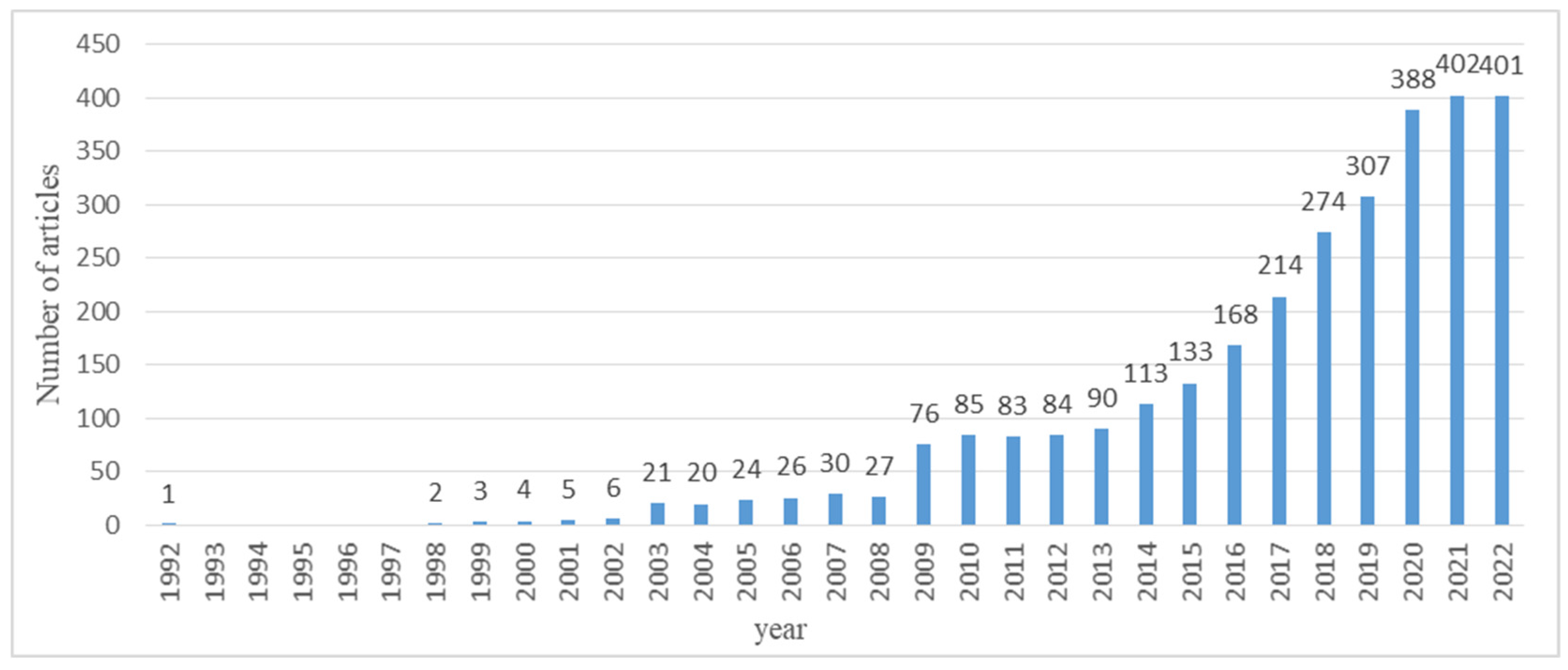
3.1. Trends in Publications

All 2987 articles were included in the word co-appearance analysis, but only representative articles were selected for a detailed explanation. Some early representative articles that were not indexed and the latest related articles were also included in the qualitative analysis hereafter.
The overall number of studies on the characteristics and driving factors of urban expansion showed an increasing trend. Before 2008, there were relatively few studies on the characteristics and driving factors of urban expansion, with fewer than 30 articles per year. From 2009, the number of studies showed a rapid upward trend, reaching 388 by 2020. The sharp increase from 2008 to 2009 is possibly due to the inclusion of ESCI, which goes back to 2005. After 2020, the growth rate slowed. The slowdown in literature growth after 2020 is possibly due to widespread ecological civilisation [37] and the economic recession after the COVID-19 pandemic in 2019 [18,19], which restricted urban expansion and shifted research interest in this field. Another possible reason is that the research time ended on 21 December 2022, and some articles published in the second half of 2022 were not indexed then (Figure 2).

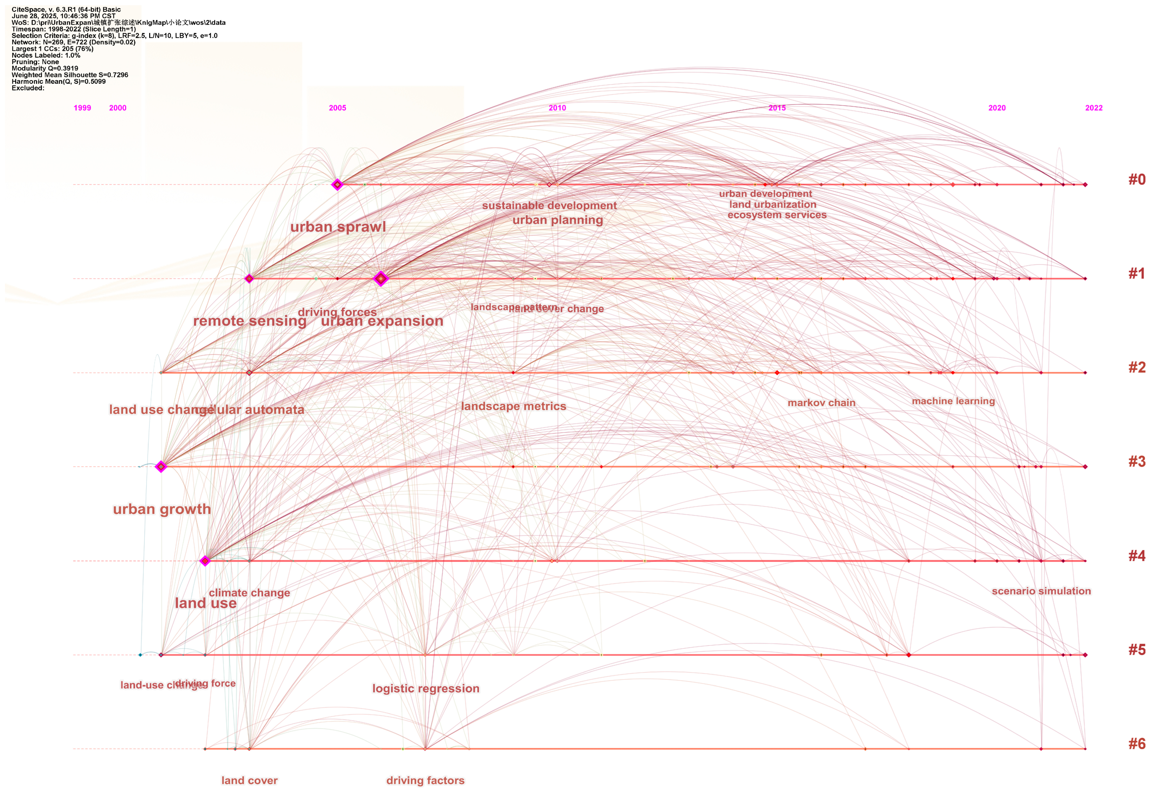
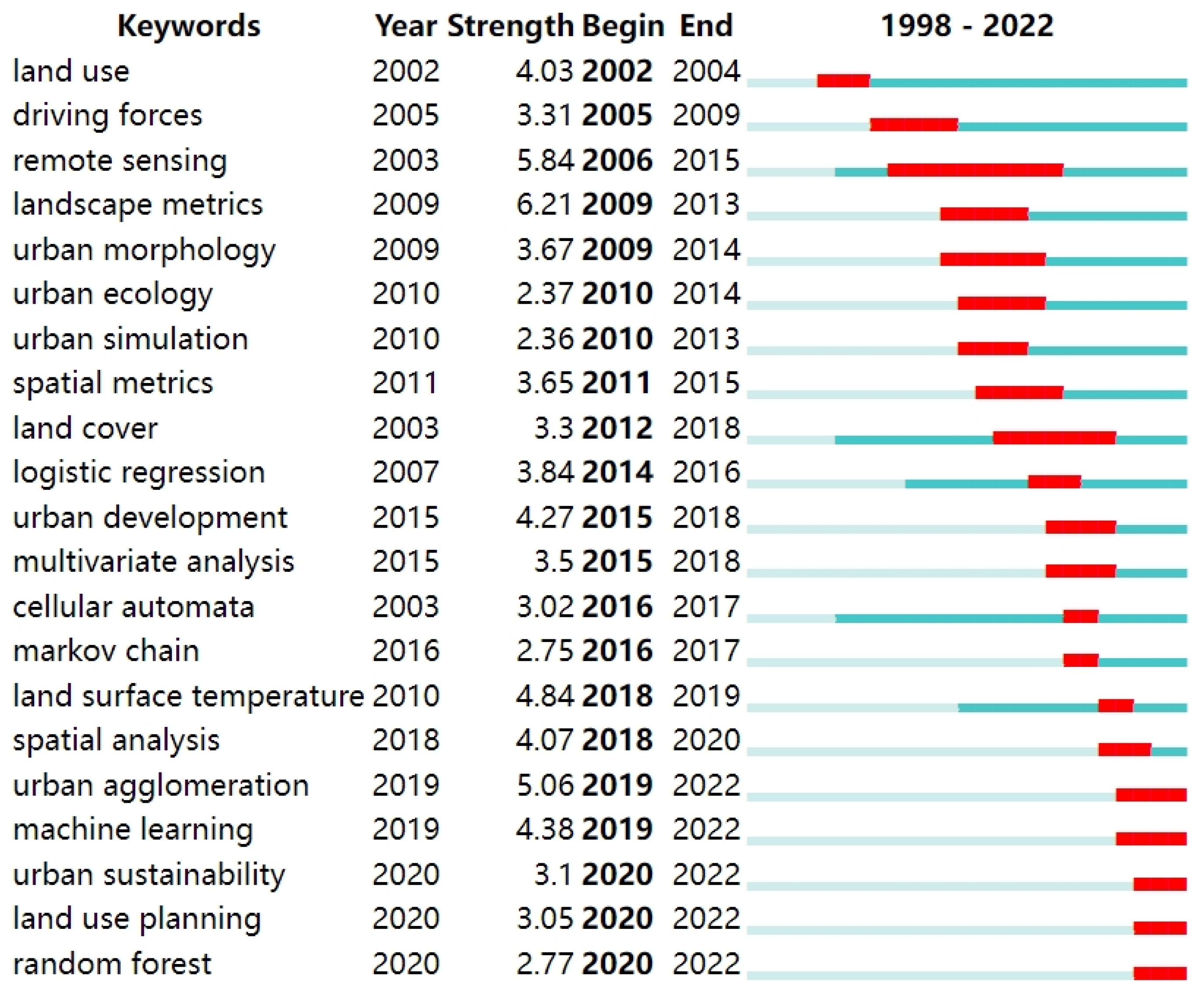
3.2. Knowledge Topic Recognition

The WCA and clustering were performed in VOSviewer 1.6.16. The research topics were divided into six categories shown in different colours (Figure 3) and summarised into three main research topics: the spatiotemporal characteristics and driving forces of urban expansion, urban growth models and simulations and the impacts of urban expansion. Categories 1 and 3 explain urban growth models and simulations, data sources and research methods. Category 2 explains the spatiotemporal characteristics and driving forces of urban expansion. Categories 4, 5 and 6 explain the impacts of urban expansion.

3.3. Research Data Sources and Methods for Urban Expansion

The study of the driving factors and driving mechanisms of urban expansion reveals the mechanisms of various factors in urban construction land growth, providing a basis for predicting the development of urban construction land and formulating control policies and spatial planning.

3.3.1. Research Data Sources

Before the popularisation of optical remote sensing technology in the 1980s [38], land transfer statistical data and land-use survey data [39] were the main data sources. While statistical and survey data are more accurate than remote sensing data, they are difficult to update and mostly confidential, making it impossible to conduct large-scale and long-term research. Remote sensing technology has advantages, such as real-time application and low costs. However, it is difficult to distinguish attribute information such as land-use type and ownership when using remote sensing data [40]. With the popularisation of the Internet and the development of information technology, big data has become an important data source for research on urban expansion. A combination of POI [41], social network software data [42] and mobile signalling data [43] can help to identify urban boundaries [41] and urban land-use types [44].

3.3.2. Research Methods and Urban Growth Models

Qualitative research was mainly used to analyse the driving mechanisms of urban expansion, such as interview and survey [45], logical reasoning, philosophical reasoning, and historical verification [46]. However, qualitative research is subjective and easily influenced by the authors’ knowledge structures. Therefore, an econometric model was introduced to validate theories and hypotheses, especially after the popularisation of optical remote sensing technology in the 1980s [38]. Common quantitative analysis methods include correlation analysis, regression analysis [47], principal component analysis (PCA) [48], factor analysis [49], path analysis [50] and structural equation modelling [51]. With the recognition of spatial dependence and heterogeneity, spatial effects were valued, leading to the development of spatial econometrics in the 1970s [52]. Since then, the explanatory power of spatial econometric models has improved, enabling the detection of spatial interactions [53]. The commonly used spatial econometric models include geographically weighted regression (GWR) [54], the spatial error model (SEM) [55] and the spatial lag model (SLM) [56]. Qualitative and quantitative analyses must be combined to discover objective phenomena and mechanisms.
Urban growth models have been extensively adopted to study and predict urban expansion. Systematic urban models have been developed since the 1950s [57]. However, early macro-models cannot simulate changes in the urban internal structure. With the development of the geographic information system (GIS) and research findings on the driving factors of urban expansion, dynamic and micro-urban models were developed to simulate urban expansion [28], such as CA [24,25] and ABM [26,27]. CA is typically used to simulate the urban expansion of different development scenarios [29]. ABM is an intelligent entity incorporating game theory, complex systems, multi-agent systems and evolutionary computation [58]. Machine learning and deep learning techniques have been applied to extract urban areas [59], and predict urban expansion [60] and urban area distributions [24].

3.4. Spatiotemporal Characteristics and Modes of Urban Expansion

3.4.1. Spatiotemporal Characteristics

Studies on the spatiotemporal characteristics of urban expansion can be divided into three levels: ① macro-scale: global, national, regional, urban agglomeration (UA) and provincial; ② meso-scale: city and county; ③ micro-scale: township, community and specific land-use unit. The global urban area increased from 362,747 km2 in 1985 to 653,354 km2 in 2015, and the rate of urban expansion (80%) was considerably higher than the rate of population growth (52%) [61]. The rate of urban expansion showed regional differences. Africa and Asia, especially India and China, experienced the highest rates of urban expansion, while the largest scale of urban expansion occurred in North America [62]. Urban expansion was mainly distributed within UAs [19]. The expansion rate of large cities was higher than that of small cities, and cities with higher administrative levels had higher expansion rates [63].

3.4.2. Types of Urban Expansion

Urban expansion takes various forms, and research has not yet developed a unified classification system. From a topological perspective, the types of urban expansion can be divided into infilling, edge expansion and outlying expansion [64]. From a landscape ecology perspective, the types of urban expansion can be divided into single-core, edge, multi-core, corridor and sprawl expansion [65]. A study conducted in the Milano area distinguished five types of urban expansion: infilling, extension, linear development, sprawl and large-scale projects [66].
For a city, the expansion type changes in different periods, regions and land-use types. These expansion types occur simultaneously, and the dominant type alternates and evolves [61]. Geophysical conditions and socioeconomic development levels cause various expansion patterns [67], leading to variations in the main expansion type of different cities. After 2005, the expansion type of Addis Ababa and Adama in Ethiopia significantly differed from that of Hawassa city: the former two were composed of a higher proportion of leapfrogging, while the main expansion type of the latter was edge expansion [68]. A study conducted in Xi’an, China, found that, before the 1980s, the main expansion type was extroverted expansion, with industry as the main driving force. After the 1980s, the main expansion type was corridor expansion, with development zones and residential areas as the main driving forces [69]. A study conducted in Srinagar, Kashmir valley, found that, the proportion of infilling type in the city area was higher than that in outer zones. Outlying type of expansion was mainly outside the city area, and edge expansion type plays a major role in urban expansion outside the city core [70]. The overall expansion type in Beijing, China, was concentric sprawl, while the expansion types of industrial land were dispersion and corridor [71].
The outlying type of expansion often occurs in the development of the new towns. In Nanchang, China, during 2000 to 2008, outlying expansion occurred mostly in the south of the city to form the new town. During 2008 to 2016, edge expansion was also mainly distributed outside the city core with a southward-moving tendency [72].

3.5. Driving Factors of Urban Expansion

The factors affecting urban expansion can mainly be divided into two categories, namely natural and socioeconomic factors [23], which can be further divided into seven categories: economic factors, demographic factors, social and cultural factors, infrastructure, political and institutional factors, natural factors and path and proximity effects (Table 1).

3.5.1. Socioeconomic Factors

Economic factors, including economic growth, incomes growth, infrastructure construction and so on, are main driving forces of urban expansion [13,73,75]. Social factors, such as social issues and demography characteristics, are considered to influence urban expansion [81,83,86], and population growth is one of the most powerful explanatory factors of urban expansion [84].
Economic growth factors, such as GDP and income growth [74], stimulates urban expansion by increasing the demand for housing, production and leisure spaces, such as new towns and industrial parks. A study conducted in China found that every 10% increase in GDP leads to a 3% increase in urban expansion [73]. The development of China’s manufacturing industry not only promoted the development of the urban economy but also attracted surplus rural labour to migrate to cities, stimulating urban expansion [75]. The development of the tertiary industry is also closely related to urban expansion. The impact of the tertiary industry on expansion within UAs is greater than that outside of UAs, and this impact increases as the level of UA development rises [19]. Research in the USA even investigated the impact of different industries in the tertiary sector on urban expansion. A high proportion of employees in the finance, insurance and real estate sectors, among others, led to intensive development, while a high proportion of employees in the retail industry led to dispersion [76]. Agriculture also influences urban expansion. The low profit of agricultural products is considered a motivating factor for local farmers to convert their land into urban land [51]. Agricultural land prices rise when agricultural productivity or product prices rise [100] and when agriculture receives financial subsidies [62], which hinders urban expansion. A study conducted in China found agricultural investment was positively correlated with urban expansion [101]. A study conducted in the USA found no significant correlation [76].
The construction of infrastructure usually plays a guiding role in urban expansion and the infrastructure itself needs to occupy land [102]. Moreover, service and transport infrastructure attracts people by improving accessibility [77], living quality [47] and employment opportunities [19], all of which increase the demand for urban land. As for transportation facilities, building highways [78], high-speed railways stations [79], ports and airports [23] promotes new town growth. Public transportation can also increase urban density. A study conducted in Italy found a negative correlation between the density of train routes and the amount of urban construction land [99]. Furthermore, public service institutions, such as parks, hospitals and schools, can drive urban development in surrounding areas [80].
Social factors mainly include social issues and spatial segregation. Social issues in inner cities, such as high crime [81] and poverty rates [82], lead to urban expansion because of the deterioration of the living environment, prompting downtown residents to move to the suburbs. Moreover, different ethnicities and socioeconomic statuses lead to residential segregation, which stimulates urban expansion [103]. Cultural factors affect urban expansion mainly through cultural preferences. Ethnic minorities tend to live together as a family unit and occupy less space per person in central communities, while white families are smaller and move to broader suburbs [83], which promotes urban expansion.
Demographic factors includes population growth, immigration, family growth, family status, etc. Population growth is one of the most important factors of urban expansion and is considered to have a significantly positive impact [84]. However, its influence varies across regions. In some developed countries and regions, such as Switzerland [104], eastern Germany [105], and southern France [74], cities grew even without population growth because the inner city population depopulated to suburban areas [85]. Demographic characteristics, such as age, education and family structure, also significantly influence urban expansion. The number of households determines the demand for houses. The smaller the family size, the more households there will be. Thus, the scale of households has a negative impact on urban expansion [86]. In Spain, elderly people and families with children prefer to live in low-density areas, while younger and more educated families prefer to live in compact areas [87]. The proportion of old people [106] and retired inhabitants [104] caused urban expansion in Switzerland. This is because people tend to move into bigger homes and do not necessarily reduce their space when their children grow up and leave the household [106].

3.5.2. Political and Institutional Factors

Urban expansion is not only driven by market forces, but also shaped by political and institutional factors, such as governance, regulation, incentives, etc.
Governance, such as administrative levels, administrative division, assessment policy and fiscal decentralisation, affects urban expansion. Cities with higher administrative levels expanded more rapidly. This is because the urban administrative system affects the distribution of economic resources and other impetuses underlying urban growth [88]. Administrative division adjustment is also an important driving factor. The relocation of administrative centres has a strong guiding effect on urban expansion [89]. When the municipality is indebted or encounter financial problems, urban expansion is strengthened [94]. The GDP-oriented promotion assessment system, land finance and fiscal decentralisation are discussed a lot in China. The GDP-oriented promotion assessment system has led to local governments competing to attract industries to settle in their areas by providing preferential land use, improved infrastructure and public services, which have also led to urban expansion [4]. Land finance is a cause of urban expansion. Because local government acquire revenue by land transfer and obtain taxes from land lessees [107]. The fiscal decentralisation is found to promote urban expansion [4,80,108].
Regulations, such as population management policy [19,90], land-use planning [91,92], building restrictions [93], government-led development [80] and so on, are important driving factors. Population management policies, such as a lenient registered residence system, allows for population flow into big cities [90], thereby promoting urban expansion [19]. Land-use planning tools, such as quotas for new urban construction land, limit the scale of urban expansion during certain periods [91], while urban growth boundaries restrict its spatial scope [92]. Government-led development strategies, such as development zones and new-town projects, further guide the direction and pace of urban expansion [80]. Conversely, various protected areas, such as natural reserves [109] and cultivated land protection areas [110], reduce urban sprawl. However, some planning regulations can have the opposite effect. For instance, building permit caps and low-density zoning in the USA [93] have been linked to increased sprawl, and regulations on high greening rates may stimulate urban expansion [111].
Taxation and development costs can also be incentives for urban expansion as well. The more municipal authorities rely on local taxes, the more they tend to provide land to increase the government’s revenue [4]. Studies on the impact of property tax on urban expansion have not yet reached a consensus. A study conducted in Spain found that a low property tax rate incentivised urban expansion, because a high tax rate is believed to increase property holding costs [94]. However, a study conducted in the USA found that higher taxation resulted in more land being consumed [112].

3.5.3. Natural Factors

Natural factors are the foundation of urban development, restricting and guiding urban expansion. Land development is limited by natural factors such as topography, geomorphology, hydrology and climate. Lands with high elevations and steep slopes are more difficult to develop [95]. However, the impact of topography also depends on larger environmental backgrounds. For example, areas with high flood risks in plain regions are not suitable for land development [96], while some areas with a high incidence of geological disasters can have unstable foundations, such as earthquake zones, geological fault zones and collapsed areas, which are not suitable for urban construction [113]. The impact of climate is less studied. A study conducted in China found that the scale of the urban construction land of cities with pleasant climates is larger than that of cities with harsh climates [73]. Additionally, urban expansion in towns near rivers or coasts tends to occur close to rivers or oceans [97].

3.5.4. Path and Proximity Effects

A strong path effect occurs in urban development [98]. High-density cities often spread less, and cities that are in the state of sprawl or designed for vehicle travel are difficult to change to compact growth [114].
Cities are also influenced by neighbouring areas [47]. Positive proximity effects have been widely found [95]. The more dispersed the neighbouring areas, the more dispersed the local city [87]. However, a study conducted in Lombardy, Italy, found a negative proximity effect [99]. Specifically, the urban expansion of middle and large municipalities resulted in a small population, a low average income, low transportation costs and high agricultural land values in neighbouring areas. The reasons for this may be that these middle and large municipalities attracted people from neighbouring municipalities, and the high value of agricultural land in neighbouring municipalities discouraged building.

3.6. Impacts of Urban Expansion

3.6.1. Socioeconomic Impact

The impact of urban expansion on economic development, industrialisation and urbanisation is often analysed from the perspective of production factors. Urban expansion significantly boosts economic growth. However, its impact across different development stages. The land input of cities in the primary production, primary industrialisation and middle industrialisation stages significantly promotes economic growth. In later industrialisation and developed stages, the economic growth of cities becomes significantly dependent on capital and labour input rather than land input [5]. At the country level, unrestrained urban sprawl causes various urban diseases, such as traffic congestion, massive idle land, infrastructure deterioration, short falls in service delivery and high urban management costs [81].

3.6.2. Ecological and Environmental Impact

Urban expansion causes a massive loss of cultivated land. During the period of 1992–2015, 70% of new urban land worldwide came from cultivated land. Urbanisation consumed cultivated land at a rate of 61,567 km2 per decade. In 1992, 65% of new urban land came from cultivated land, rising to 71% by 2015 [61]. From the late 1980s to 2000, approximately 2.4 × 10⁵ km2 of cultivated land worldwide was converted into urban land, accounting for 2% of the total global cultivated land [16].
Urban expansion mainly affects environmental elements such as water, soil, atmosphere, biodiversity and climate. During urban construction, humans modify hydro systems for production and daily life, for example, by draining small ponds and cutting off curved rivers [1]. This increases impervious covers and reduces surface infiltration and groundwater levels. The decline in vegetation reduces surface evaporation and interception, increases surface runoff and river sedimentation and correspondingly exacerbates the threat of potential floods [115]. Vehicle exhaust and road dust are sources of urban air and soil pollution [116]. A study conducted in metropolitan America found that the star-shaped urban form is more effective in eliminating air pollution than concentric circles, belts, squares, and rings [117]. Urban expansion encroaches on biological habitats, which are separated by the construction of linear transportation infrastructure, thereby threatening biodiversity [118]. Urban centres, especially in developed countries, are the main source of greenhouse-gas emission [1]. Urban expansion exacerbates carbon emissions, which leads to global climate change [119]. Urban expansion also changes the underlying surface, leading to changes in the absorption, emission and self-radiation intensity of solar radiation, which inevitably affects regional microclimates. The urban heat island effect is believed to be caused by urban expansion [120]. One way to alleviate the urban heat island effect is to improve green coverage, which leads to an increase in water consumption [1].

3.7. Changes in Research

The research topics are shown in timeline view in Figure 4. The number at the top represents the time. The words with “# number” on the right represent the keyword cluster. However, this classification was inappropriate, and we used the classification by VOSviewer 1.6.16 in Section 3.2. The words under the timeline are the frequent keywords that appeared in this period. The size of keywords represents centrality. The top 21 keywords with the strongest citation bursts are shown in Figure 5. The thick dark blue line represents the time period when the keyword appears. The thick red line represents the time period when the keyword bursts.
Advancements in information technology have affected the methods and data sources used in urban expansion studies. In terms of research data sources, remote sensing was observed from 2003 to 2022 (Figure 4 and Figure 5), indicating that remote sensing is a long-term primary data source. Statistical data is another long-term widely used data source. With the advancement of the Internet and computing power, studies which use big data such as POI [41,44], mobile signalling [43], and social-networking application data [42], burst. In terms of research methods, logistic regression (2007–2022) and cellular automata (2003–2022) were found to be long-term primary methods. After 2015, Markov chain (2016–2022), machine learning (2019–2022), and random forest (2020–2022) are new methods (Figure 4 and Figure 5). Qualitative research and econometric models are long-term widely used methods to detect driving factors and influencing mechanism. Interview, survey [45], summary and inductive reasoning [121] are widely used qualitative methods. Traditional economic models, such as logistic regression [122] and linear regression [123], are long-term used. With the awareness of spatial dependence and spatial heterogeneity, the spatial econometric model was developed in 1975 and applied widely [54,55,56,124]. With the advancement of computer science, the CA-based models and ABMs were developed to simulate urban expansion after 1970 [28]. With further development of computing power, Markov chain [25,125], machine learning and deep learning techniques [60] have been used to detect rules of urban growth and simulate urban expansion. The application of these technologies and data led to an increase in large-scale research [61] and improved accuracy [41].
In terms of research topics, land use (2002–2022), driving force/factors (2005–2022), and climate change were found to be long-term primary topics. After 2010, the number of keywords on ecological and environmental impacts increased, such as urban ecology (2010–2022), land surface temperature (2010–2022), urban sustainability (2020–2022), sustainable development, ecosystem service. Moreover, after 2010, more attention was paid to policy and institutional factors, such as urban planning and land-use planning (2020–2022) (Figure 4 and Figure 5). Land-use change and driving factors are long-term primary topics. After 2010, studies on ecological and environmental impact burst, covering topics such as urban ecology [126], sustainable development [127] and ecosystem service [128]. Impacts of spatial planning and land-use planning [91] and simulation of different plans scenarios [129] received more attention. Urban agglomerations, as an advanced form of urban development, also received more attention [19,21,130].

4. Discussion

4.1. Research Prospects

Due to the diversity of global socioeconomic development levels, political systems and natural conditions, the effects of some driving factors differ. In Europe and North America, the influence of government regulation is relatively small, whereas in China, it is one of the most critical factors because of differences in social systems [4]. The influences of the tertiary industry [19,76], agriculture [51,76,101], property taxes [94,112], neighbouring regions [95,99] differs across regions or scales. Many studies only indicated the statistical correlations of driving factors, without investigating their mechanisms. Further studies on these controversial factors and their mechanisms are required.
Moreover, the effects of some factors or their impact mechanisms remain unknown. Compared with demographic and economic factors, studies on political and institutional factors, such as subsidies and taxation, planning and control, land governance policies and development strategies, are insufficient [13]. This is because policies are difficult to quantify, and quantitative management indicator data are difficult to obtain. Land governance policies, such as land property rights [131,132] and inefficient construction land redevelopment [133], are increasingly recognised as critical influencing factors of urban expansion. State owned or privately owned land will affect the cost of urban development [131]. The pilots policies of inefficient construction land redevelopment encourage the reuse of stock urban construction land [133]. The pilots policies of rural collective construction land are applicable to the land market [134]. If the pilot policy is promoted, then the demand for new urban construction land will decrease, thereby curbing urban expansion. The development of the digital economy can also improve land-use efficiency [135], which may have a negative impact on urban expansion. New development strategies and new economic industries, such as the digital economy [135], are also constantly emerging. The new urbanisation strategy [14,15,16,17], which emphasises ecological civilization, sustainable development, human-centred development and urban-rural coordination, has been widely recognised. In the course of China’s shift from extensive to high-quality development, the ecological protection red line, farmland and permanent basic farmland protection red line and urban development boundaries in spatial planning restrict urban expansion [136]. The digital economy can accelerate the upgrading of industrial composition, and improve land-use efficiency [135], which may have a negative correlation with urban expansion. These changes in the economic situation and regulation policies are believed to cause changes in spatiotemporal characteristics and the driving factors of urban expansion.
The data sources and methods used to study urban expansion will become more diverse. The application of big data and machine learning makes the research scale more refined and urban growth models more intelligent. However, big data and machine learning cannot completely replace traditional research. Despite the large scale of big data, it is not comprehensive and cannot cover every individual. At the same time, machine learning cannot explain the mechanisms of phenomena. Thus, traditional theoretical and micro model studies remain essential.

4.2. Limitations

Although bibliometric method is a quantitative analysis method and more intuitive [31], the approach still has some limitations. Only articles that were published during the period of 1992–2022 from WOS database were included in MKD analysis. Articles published before 1992 or after 2022 and important non-English articles were not included in the MKD analysis. In order to conduct a more comprehensive analysis, we selected some representative articles that were not indexed and include them in the discussion. Therefore, further studies can conduct bibliometric analysis or meta-analyses incorporating Scopus, Google Scholar, non-English and grey literature, and compare the results with this study to capture the diversity.

5. Conclusions

Land is a fundamental production factor in urban development, and urban expansion has a profound impact on both society and the environment. In this study, VOSviewer 1.6.16 and CiteSpace 6.3.R1 were used to conduct a bibliometric analysis of 2987 articles published during the period of 1992–2022 and obtained from the WoS database in order to detect the research hotspots and trends of urban expansion and its driving factors. The number of articles significantly increased during the period of 1992–2022, indicating that an increasing number of scholars focused on urban expansion. A WCA showed that the main research topics were the spatiotemporal characteristics and driving forces of urban expansion, urban growth models and simulation, and the impacts of urban expansion. The rate of urban expansion showed regional differences. The driving factors of urban expansion could be divided into socioeconomic factors, political and institutional factors, natural factors, path effects, and proximity effects. While urban expansion promoted economic development, it also resulted in the loss of cultivated land and adversely affected ecological environments. A keyword timeline analysis and keyword burst detection helped to identify the evolution of hotspots. Statistical data, remote sensing data, econometric models, and CA-based models were the most commonly used data and models. Big data and deep learning techniques were recently applied due to advancements in information techniques. Land-use change and driving factors were found to be long-term research topics. With the increasing awareness of environmental protection, studies on the ecological and environmental impacts of urban expansion and spatial planning regulation burst after 2010. Impacts of land-use planning and simulation of different plans scenarios also received more attention. Urban agglomerations, as an advanced form of urban development, have also received attention recently.
Due to differences in socioeconomic development levels, political systems, and natural conditions, the impacts of some driving factors differ. The impacts of some political and institutional factors, such as new development strategies, regulation policies, and economic industries, remain unknown. Many studies did not investigate the mechanisms of the driving factors. Further research on these controversial and unknown factors and their mechanisms is needed. We must note that, although some representative articles were included in the discussion, many non-index articles were not reviewed. Further studies could review these articles and conduct comparative research.

Author Contributions

Conceptualization, M.L. (Ming Li), Y.C. and M.L. (Mengyin Liang); methodology, M.L. (Ming Li); software, J.D.; validation, M.L. (Ming Li); formal analysis, J.D.; resources, J.D.; writing—original draft preparation, M.L. (Ming Li), Y.C. and M.L. (Mengyin Liang); writing—review and editing, M.L. (Ming Li), Y.C. and M.L. (Mengyin Liang); visualisation, J.D.; supervision, M.L. (Mengyin Liang); funding acquisition, J.S., Y.C. and M.L. (Mengyin Liang). All authors have read and agreed to the published version of the manuscript.

Funding

This research was funded by the Youth Project Fund of Guangzhou Academy of Social Sciences (24QN004), National Key Research and Development Program of China (2023YFC3007105 and 2022YFC3802805).

Data Availability Statement

Data are contained within the article.

Conflicts of Interest

The authors declare no conflicts of interest.

References

  1. Grimm, N.B.; Faeth, S.H.; Golubiewski, N.E.; Redman, C.L.; Wu, J.; Bai, X.; Briggs, J.M. Global Change and the Ecology of Cities. Science 2008, 319, 756–760. [Google Scholar] [CrossRef]
  2. United Nations, Department of Economic and Social Affairs. World Population Prospects 2019 Highlights; United Nations, Department of Economic and Social Affairs Population Division: New York, NY, USA, 2019. [Google Scholar]
  3. Lu, D. Urbanization Process and Spatial Sprawl in China. Urban Plan. Forum 2007, 170, 47–52. [Google Scholar]
  4. Gao, J.; Wei, Y.D.; Chen, W.; Chen, J. Economic Transition and Urban Land Expansion in Provincial China. Habitat Int. 2014, 44, 461–473. [Google Scholar] [CrossRef]
  5. Jin, W.; Zhou, C.; Luo, L. Impact of Land Input on Economic Growth at Different Stages of Development in Chinese Cities and Regions. Sustainability 2018, 10, 2847. [Google Scholar] [CrossRef]
  6. Foley, J.A.; DeFries, R.; Asner, G.P.; Barford, C.; Bonan, G.; Carpenter, S.R.; Chapin, F.S.; Coe, M.T.; Daily, G.C.; Gibbs, H.K.; et al. Global Consequences of Land Use. Science 2005, 309, 570–574. [Google Scholar] [CrossRef]
  7. Krauss, J.; Bommarco, R.; Guardiola, M.; Heikkinen, R.K.; Helm, A.; Kuussaari, M.; Lindborg, R.; Öckinger, E.; Pärtel, M.; Pino, J.; et al. Habitat Fragmentation Causes Immediate and Time-delayed Biodiversity Loss at Different Trophic Levels. Ecol. Lett. 2010, 13, 597–605. [Google Scholar] [CrossRef]
  8. Ren, Q.; He, C.; Huang, Q.; Zhang, D.; Shi, P.; Lu, W. Impacts of Global Urban Expansion on Natural Habitats Undermine the 2050 Vision for Biodiversity. Resour. Conserv. Recycl. 2023, 190, 106834. [Google Scholar] [CrossRef]
  9. Ju, H.; Zhang, Z.; Zhao, X.; Wang, X.; Wu, W.; Yi, L.; Wen, Q.; Liu, F.; Xu, J.; Hu, S.; et al. The Changing Patterns of Cropland Conversion to Built-up Land in China from 1987 to 2010. J. Geogr. Sci. 2018, 28, 1595–1610. [Google Scholar] [CrossRef]
  10. Liu, Y.; Ou, C.; Liu, Y.; Cao, Z.; Robinson, G.M.; Li, X. Unequal Impacts of Global Urban–Rural Settlement Construction on Cropland and Production over the Past Three Decades. Sci. Bull. 2025, 70, 1699–1709. [Google Scholar] [CrossRef]
  11. Khamchiangta, D.; Dhakal, S. Future Urban Expansion and Local Climate Zone Changes in Relation to Land Surface Temperature: Case of Bangkok Metropolitan Administration, Thailand. Urban Clim. 2021, 37, 100835. [Google Scholar] [CrossRef]
  12. Cruz-Sandoval, M.; Gómez-Zaldívar, F.; Peraza-Mues, G.; Ponce-López, R. The Interplay of Economic Complexity and Urban Sprawl in Shaping Socio-Spatial Segregation in Mexico. Appl. Geogr. 2025, 181, 103690. [Google Scholar] [CrossRef]
  13. Colsaet, A. What Drives Land Take and Urban Land Expansion? A Systematic Review. Land Use Policy 2018, 79, 339–349. [Google Scholar] [CrossRef]
  14. Chen, M.; Zhou, Y.; Huang, X.; Ye, C. The Integration of New-Type Urbanization and Rural Revitalization Strategies in China: Origin, Reality and Future Trends. Land 2021, 10, 207. [Google Scholar] [CrossRef]
  15. Liu, Y.; Ma, C.; Ma, L.; Li, N. Ecological Effects of Land Use and Land Cover Change in the Typical Ecological Functional Zones of Egypt. Ecol. Indic. 2024, 168, 112747. [Google Scholar] [CrossRef]
  16. Fazal, S. Urban Expansion and Loss of Agricultural Land—A GIS Based Study of Saharanpur City, India. Environ. Urban. 2000, 12, 133–149. [Google Scholar] [CrossRef]
  17. Dieleman, H. Urban Agriculture in Mexico City; Balancing between Ecological, Economic, Social and Symbolic Value. J. Clean. Prod. 2017, 163, S156–S163. [Google Scholar] [CrossRef]
  18. Rontos, K.; Mosconi, E.M.; Gianvincenzi, M.; Moretti, S.; Salvati, L. Toward a Spatially Segregated Urban Growth? Austerity, Poverty, and the Demographic Decline of Metropolitan Greece. Data 2023, 8, 53. [Google Scholar] [CrossRef]
  19. Li, M.; Cao, Y.; Song, J.; Li, H.; Liang, M. Spatiotemporal Characteristics and Determinants of Urban Expansion in China: Perspective of Urban Agglomerations. Front. Earth Sci. 2025, 12, 1523020. [Google Scholar] [CrossRef]
  20. Ewing, R.; Hamidi, S. Compactness versus Sprawl: A Review of Recent Evidence from the United States. J. Plan. Lit. 2015, 30, 413–432. [Google Scholar] [CrossRef]
  21. Basu, T.; Das, A.; Pereira, P. Exploring the Drivers of Urban Expansion in a Medium-Class Urban Agglomeration in India Using the Remote Sensing Techniques and Geographically Weighted Models. Geogr. Sustain. 2023, 4, 150–160. [Google Scholar] [CrossRef]
  22. Salem, M.; Tsurusaki, N.; Divigalpitiya, P. Analyzing the Driving Factors Causing Urban Expansion in the Peri-Urban Areas Using Logistic Regression: A Case Study of the Greater Cairo Region. Infrastructures 2019, 4, 4. [Google Scholar] [CrossRef]
  23. Li, G.; Sun, S.; Fang, C. The Varying Driving Forces of Urban Expansion in China: Insights from a Spatial-Temporal Analysis. Landsc. Urban Plan. 2018, 174, 63–77. [Google Scholar] [CrossRef]
  24. Gündüz, H.İ. Land-Use Land-Cover Dynamics and Future Projections Using GEE, ML, and QGIS-MOLUSCE: A Case Study in Manisa. Sustainability 2025, 17, 1363. [Google Scholar] [CrossRef]
  25. Losiri, C.; Nagai, M.; Ninsawat, S.; Shrestha, R. Modeling Urban Expansion in Bangkok Metropolitan Region Using Demographic–Economic Data through Cellular Automata-Markov Chain and Multi-Layer Perceptron-Markov Chain Models. Sustainability 2016, 8, 686. [Google Scholar] [CrossRef]
  26. Wang, J.; Li, G.; Lu, H.; Wu, Z. Urban Models: Progress and Perspective. Sustain. Futures 2024, 7, 100181. [Google Scholar] [CrossRef]
  27. Gao, Y.; Liu, D.; Zheng, X.; Wang, X.; Ai, G. Urban Expansion Scenario Prediction Model: Combining Multi-Source Big Data, a Graph Attention Network, a Vector Cellular Automata, and an Agent-Based Model. Remote Sens. 2025, 17, 2272. [Google Scholar] [CrossRef]
  28. Li, X.; Gong, P. Urban Growth Models: Progress and Perspective. Sci. Bull. 2016, 61, 1637–1650. [Google Scholar] [CrossRef]
  29. Tong, X.; Feng, Y. A Review of Assessment Methods for Cellular Automata Models of Land-Use Change and Urban Growth. Int. J. Geogr. Inf. Sci. 2020, 34, 866–898. [Google Scholar] [CrossRef]
  30. Chen, C. Science Mapping: A Systematic Review of the Literature. J. Data Inf. Sci. 2017, 2, 1–40. [Google Scholar] [CrossRef]
  31. Chen, C. CiteSpace II: Detecting and Visualizing Emerging Trends and Transient Patterns in Scientific Literature. J. Am. Soc. Inf. Sci. Technol. 2006, 57, 359–377. [Google Scholar] [CrossRef]
  32. Farkas, J.Z.; Hoyk, E.; De Morais, M.B.; Csomós, G. A Systematic Review of Urban Green Space Research over the Last 30 Years: A Bibliometric Analysis. Heliyon 2023, 9, e13406. [Google Scholar] [CrossRef] [PubMed]
  33. Shao, H.; Kim, G.; Li, Q.; Newman, G. Web of Science-Based Green Infrastructure: A Bibliometric Analysis in CiteSpace. Land 2021, 10, 711. [Google Scholar] [CrossRef] [PubMed]
  34. Meng, L.; Wen, K.-H.; Brewin, R.; Wu, Q. Knowledge Atlas on the Relationship between Urban Street Space and Residents’ Health—A Bibliometric Analysis Based on VOSviewer and CiteSpace. Sustainability 2020, 12, 2384. [Google Scholar] [CrossRef]
  35. Waltman, L.; Van Eck, N.J.; Noyons, E.C.M. A Unified Approach to Mapping and Clustering of Bibliometric Networks. J. Informetr. 2010, 4, 629–635. [Google Scholar] [CrossRef]
  36. van Eck, N.J.; Waltman, L. Software Survey: VOSviewer, a Computer Program for Bibliometric Mapping. Scientometrics 2010, 84, 523–538. [Google Scholar] [CrossRef]
  37. Fan, Y.; Ma, S. Integrating Fuzzy Analytic Hierarchy Process into Ecosystem Service-Based Spatial Planning: A Case Study of the Shenyang Metropolitan Area, China. Ecol. Inform. 2024, 81, 102625. [Google Scholar] [CrossRef]
  38. Kuang, W. 70 Years of Urban Expansion across China: Trajectory, Pattern, and National Policies. Sci. Bull. 2020, 65, 1970–1974. [Google Scholar] [CrossRef]
  39. Tian, L.; Shen, T. Evaluation of Plan Implementation in the Transitional China: A Case of Guangzhou City Master Plan. Cities 2011, 28, 11–27. [Google Scholar] [CrossRef]
  40. He, X.; Zhou, Y. Urban Spatial Growth and Driving Mechanisms under Different Urban Morphologies: An Empirical Analysis of 287 Chinese Cities. Landsc. Urban Plan. 2024, 248, 105096. [Google Scholar] [CrossRef]
  41. He, X.; Yuan, X.; Zhang, D.; Zhang, R.; Li, M.; Zhou, C. Delineation of Urban Agglomeration Boundary Based on Multisource Big Data Fusion—A Case Study of Guangdong–Hong Kong–Macao Greater Bay Area (GBA). Remote Sens. 2021, 13, 1801. [Google Scholar] [CrossRef]
  42. Long, Y.; Zhai, W.; Shen, Y.; Ye, X. Understanding Uneven Urban Expansion with Natural Cities Using Open Data. Landsc. Urban Plan. 2018, 177, 281–293. [Google Scholar] [CrossRef]
  43. Ma, L.; Xiu, C. Analyzing the Structure of Residence–Leisure Network in Shenyang City. Land 2022, 11, 2111. [Google Scholar] [CrossRef]
  44. Liu, X.; He, J.; Yao, Y.; Zhang, J.; Liang, H.; Wang, H.; Hong, Y. Classifying Urban Land Use by Integrating Remote Sensing and Social Media Data. Int. J. Geogr. Inf. Sci. 2017, 31, 1675–1696. [Google Scholar] [CrossRef]
  45. Ogara, D.A.E.; Akrofi, M.M.; Muthoni, V. Understanding the Socio-Economic and Environmental Effects of Port Development on Urban and Marine Environments: A Case of Mombasa Port Expansion (2006–2021) on Urban and Marine Environments in Kenya. Ocean Coast. Manag. 2025, 267, 107581. [Google Scholar] [CrossRef]
  46. Liu, G.; Li, J.; Nie, P. Tracking the History of Urban Expansion in Guangzhou (China) during 1665–2017: Evidence from Historical Maps and Remote Sensing Images. Land Use Policy 2022, 112, 105773. [Google Scholar] [CrossRef]
  47. Li, M.; Zhang, G.; Liu, Y.; Cao, Y.; Zhou, C. Determinants of Urban Expansion and Spatial Heterogeneity in China. Int. J. Environ. Res. Public Health 2019, 16, 3706. [Google Scholar] [CrossRef]
  48. Zhang, S.; Wu, Q.; Zheng, H.; Zhou, H.; Shao, Q. Sustainable Land Urbanization, Urban Amenities, and Population Urbanization: Evidence from City-level Data in China. Soc. Sci. Q. 2021, 102, 1686–1698. [Google Scholar] [CrossRef]
  49. Dinda, S.; Das, K.; Das Chatterjee, N.; Ghosh, S. Integration of GIS and Statistical Approach in Mapping of Urban Sprawl and Predicting Future Growth in Midnapore Town, India. Model. Earth Syst. Environ. 2019, 5, 331–352. [Google Scholar] [CrossRef]
  50. Bagheri, B.; Sahar Nedae, T. An Explanation of Urban Sprawl Phenomenon in Shiraz Metropolitan Area (SMA). Cities 2018, 73, 71–90. [Google Scholar] [CrossRef]
  51. Azadi, H.; Barati, A.A.; Rafiaani, P.; Raufirad, V.; Zarafshani, K.; Mamoorian, M.; Van Passel, S.; Lebailly, P. Agricultural Land Conversion Drivers in Northeast Iran: Application of Structural Equation Model. Appl. Spat. Anal. 2016, 9, 591–609. [Google Scholar] [CrossRef]
  52. Bagan, H.; Yamagata, Y. Analysis of Urban Growth and Estimating Population Density Using Satellite Images of Nighttime Lights and Land-Use and Population Data. GISci. Remote Sens. 2015, 52, 765–780. [Google Scholar] [CrossRef]
  53. Zhou, C.; Zhang, R.; Ning, X.; Zheng, Z. Spatial-Temporal Characteristics in Grain Production and Its Influencing Factors in the Huang-Huai-Hai Plain from 1995 to 2018. Int. J. Environ. Res. Public Health 2020, 17, 9193. [Google Scholar] [CrossRef]
  54. Li, S.; Zhou, C.; Wang, S.; Gao, S.; Liu, Z. Spatial Heterogeneity in the Determinants of Urban Form: An Analysis of Chinese Cities with a GWR Approach. Sustainability 2019, 11, 479. [Google Scholar] [CrossRef]
  55. Li, S.; Wang, S. Examining the Effects of Socioeconomic Development on China’s Carbon Productivity: A Panel Data Analysis. Sci. Total Environ. 2019, 659, 681–690. [Google Scholar] [CrossRef]
  56. Liu, X.; Xu, H.; Zhang, M. The Effects of Urban Expansion on Carbon Emissions: Based on the Spatial Interaction and Transmission Mechanism. J. Clean. Prod. 2024, 434, 140019. [Google Scholar] [CrossRef]
  57. Batty, M. Urban Modeling. In International Encyclopedia of Human Geography; Elsevier: Oxford, UK, 2009; pp. 51–58. ISBN 978-0-08-044910-4. [Google Scholar]
  58. Brown, D.G.; Riolo, R.; Robinson, D.T.; North, M.; Rand, W. Spatial Process and Data Models: Toward Integration of Agent-Based Models and GIS. J. Geogr. Syst. 2005, 7, 25–47. [Google Scholar] [CrossRef]
  59. Choung, Y.-J.; Kim, J.-M. Study of the Relationship between Urban Expansion and PM10 Concentration Using Multi-Temporal Spatial Datasets and the Machine Learning Technique: Case Study for Daegu, South Korea. Appl. Sci. 2019, 9, 1098. [Google Scholar] [CrossRef]
  60. Rimal, B.; Sloan, S.; Keshtkar, H.; Sharma, R.; Rijal, S.; Shrestha, U.B. Patterns of Historical and Future Urban Expansion in Nepal. Remote Sens. 2020, 12, 628. [Google Scholar] [CrossRef]
  61. Liu, X.; Huang, Y.; Xu, X.; Li, X.; Li, X.; Ciais, P.; Lin, P.; Gong, K.; Ziegler, A.D.; Chen, A.; et al. High-Spatiotemporal-Resolution Mapping of Global Urban Change from 1985 to 2015. Nat. Sustain. 2020, 3, 564–570. [Google Scholar] [CrossRef]
  62. Seto, K.C.; Fragkias, M.; Guneralp, B.; Reilly, M.K. A Meta-Analysis of Global Urban Land Expansion. PLoS ONE 2011, 6, e23777. [Google Scholar] [CrossRef]
  63. Li, Y.; Xiong, W. A Spatial Panel Data Analysis of China’s Urban Land Expansion, 2004–2014. Pap. Reg. Sci. 2019, 98, 393–408. [Google Scholar] [CrossRef]
  64. Liu, X.; Li, X.; Chen, Y.; Tan, Z.; Li, S.; Ai, B. A New Landscape Index for Quantifying Urban Expansion Using Multi-Temporal Remotely Sensed Data. Landsc. Ecol. 2010, 25, 671–682. [Google Scholar] [CrossRef]
  65. Forman, R.T.T. Land Mosaics: The Ecology of Landscapes and Regions; Cambridge University Press: Cambridge, UK, 1995. [Google Scholar]
  66. Camagni, R.; Gibelli, M.C.; Rigamonti, P. Urban Mobility and Urban Form: The Social and Environmental Costs of Different Patterns of Urban Expansion. Ecol. Econ. 2002, 40, 199–216. [Google Scholar] [CrossRef]
  67. Deng, X.; Zhan, J.; Chen, R. The Patterns and Driving Forces of Urban Sprawl in China. In Proceedings of the Proceedings. 2005 IEEE International Geoscience and Remote Sensing Symposium, 2005. IGARSS ’05, Seoul, Republic of Korea, 29 July 2005; IEEE: Piscataway, NJ, USA; Volume 3, pp. 1511–1513. [Google Scholar]
  68. Terfa, B.K.; Chen, N.; Liu, D.; Zhang, X.; Niyogi, D. Urban Expansion in Ethiopia from 1987 to 2017: Characteristics, Spatial Patterns, and Driving Forces. Sustainability 2019, 11, 2973. [Google Scholar] [CrossRef]
  69. Qian, Z.; Chen, X. Spatial Expansion in Urban Fringe of Xi’an. Hum. Geogr. 2005, 20, 54–58. [Google Scholar]
  70. Anees, M.M.; Mann, D.; Sharma, M.; Banzhaf, E.; Joshi, P.K. Assessment of Urban Dynamics to Understand Spatiotemporal Differentiation at Various Scales Using Remote Sensing and Geospatial Tools. Remote Sens. 2020, 12, 1306. [Google Scholar] [CrossRef]
  71. Shenghe, L.; Prieler, S.; Xiubin, L. Spatial Patterns of Urban Land Use Growth in Beijing. J. Geogr. Sci. 2002, 12, 266–274. [Google Scholar] [CrossRef]
  72. Liu, D.; Chen, N. Satellite Monitoring of Urban Land Change in the Middle Yangtze River Basin Urban Agglomeration, China between 2000 and 2016. Remote Sens. 2017, 9, 1086. [Google Scholar] [CrossRef]
  73. Deng, X.; Huang, J.; Rozelle, S.; Uchida, E. Economic Growth and the Expansion of Urban Land in China. Urban Stud. 2010, 47, 813–843. [Google Scholar] [CrossRef]
  74. Olivier, C.; Laurence, D.; Claude, N. Determinants of Local Public Policies for Farmland Preservation and Urban Expansion: A French Illustration. Land Econ. 2014, 90, 411–433. [Google Scholar] [CrossRef]
  75. Deng, X.; Huang, J.; Rozelle, S.; Uchida, E. Growth, Population and Industrialization, and Urban Land Expansion of China. J. Urban Econ. 2008, 63, 96–115. [Google Scholar] [CrossRef]
  76. Wassmer, R.W. The Influence of Local Urban Containment Policies and Statewide Growth Management on the Size of United States Urban Areas. J. Reg. Sci. 2006, 46, 25–65. [Google Scholar] [CrossRef]
  77. Alsharif, A.A.A.; Pradhan, B. Urban Sprawl Analysis of Tripoli Metropolitan City (Libya) Using Remote Sensing Data and Multivariate Logistic Regression Model. J. Indian Soc. Remote Sens. 2014, 42, 149–163. [Google Scholar] [CrossRef]
  78. Handy, S. Smart Growth and the Transportation-Land Use Connection: What Does the Research Tell Us? Int. Reg. Sci. Rev. 2005, 28, 146–167. [Google Scholar] [CrossRef]
  79. Wang, S.; Wang, J.; Liu, X. How Do Urban Spatial Structures Evolution in the High-Speed Rail Era? Case Study of Yangtze River Delta, China. Habitat Int. 2019, 93, 102051. [Google Scholar] [CrossRef]
  80. Chen, J.; Gao, J.; Chen, W. Urban Land Expansion and the Transitional Mechanisms in Nanjing, China. Habitat Int. 2016, 53, 274–283. [Google Scholar] [CrossRef]
  81. Helu, M.F.A. Urban Sprawl in Palestinian Occupied Territories: Causes, Consequences and Future. Environ. Urban. ASIA 2012, 3, 121–141. [Google Scholar] [CrossRef]
  82. Kurban, H.; Persky, J. Do Metropolitan Areas with Rich Central Cities Experience Less Sprawl? Econ. Dev. Q. 2007, 21, 179–184. [Google Scholar] [CrossRef]
  83. Heidelberg, K.S. Growth at the Fringe: The Influence of Political Fragmentation in United States Metropolitan Areas. Pap. Reg. Sci. 2003, 82, 475–499. [Google Scholar] [CrossRef]
  84. Angel, S.; Parent, J.; Civco, D.L.; Blei, A.; Potere, D. The Dimensions of Global Urban Expansion: Estimates and Projections for All Countries, 2000–2050. Prog. Plan. 2011, 75, 53–107. [Google Scholar] [CrossRef]
  85. Maimaitijiang, M.; Ghulam, A.; Sandoval, J.S.O.; Maimaitiyiming, M. Drivers of Land Cover and Land Use Changes in St. Louis Metropolitan Area over the Past 40 Years Characterized by Remote Sensing and Census Population Data. Int. J. Appl. Earth Obs. Geoinf. 2015, 35, 161–174. [Google Scholar] [CrossRef]
  86. Pirotte, A.; Madre, J.-L. Determinants of Urban Sprawl in France: An Analysis Using a Hierarchical Bayes Approach on Panel Data. Urban Stud. 2011, 48, 2865–2886. [Google Scholar] [CrossRef]
  87. Gómez-Antonio, M.; Hortas-Rico, M.; Linna, L. The Causes of Urban Sprawl in Spanish Urban Areas: A Spatial Approach. Spat. Econ. Anal. 2016, 11, 219–247. [Google Scholar] [CrossRef]
  88. Li, H.; Wei, Y.D.; Liao, F.H.; Huang, Z. Administrative Hierarchy and Urban Land Expansion in Transitional China. Appl. Geogr. 2015, 56, 177–186. [Google Scholar] [CrossRef]
  89. Feng, R.; Wang, K. The Direct and Lag Effects of Administrative Division Adjustment on Urban Expansion Patterns in Chinese Mega-Urban Agglomerations. Land Use Policy 2022, 112, 105805. [Google Scholar] [CrossRef]
  90. Zhou, C.; Li, M.; Zhang, G.; Chen, J.; Zhang, R.; Cao, Y. Spatiotemporal Characteristics and Determinants of Internal Migrant Population Distribution in China from the Perspective of Urban Agglomerations. PLoS ONE 2021, 16, e0246960. [Google Scholar] [CrossRef]
  91. Shen, X.; Wang, X.; Zhang, Z.; Lu, Z.; Lv, T. Evaluating the Effectiveness of Land Use Plans in Containing Urban Expansion: An Integrated View. Land Use Policy 2019, 80, 205–213. [Google Scholar] [CrossRef]
  92. Zhou, Y.; Chang, J.; Feng, S. Effects of Urban Growth Boundaries on Urban Spatial Structural and Ecological Functional Optimization in the Jining Metropolitan Area, China. Land Use Policy 2022, 117, 106113. [Google Scholar] [CrossRef]
  93. Hersperger, A.M.; Bürgi, M. Going beyond Landscape Change Description: Quantifying the Importance of Driving Forces of Landscape Change in a Central Europe Case Study. Land Use Policy 2009, 26, 640–648. [Google Scholar] [CrossRef]
  94. Fernandez Milan, B.; Creutzig, F. Municipal Policies Accelerated Urban Sprawl and Public Debts in Spain. Land Use Policy 2016, 54, 103–115. [Google Scholar] [CrossRef]
  95. Li, X.; Zhou, W.; Ouyang, Z. Forty Years of Urban Expansion in Beijing: What Is the Relative Importance of Physical, Socioeconomic, and Neighborhood Factors? Appl. Geogr. 2013, 38, 1–10. [Google Scholar] [CrossRef]
  96. Braimoh, A.K.; Onishi, T. Spatial Determinants of Urban Land Use Change in Lagos, Nigeria. Land Use Policy 2007, 24, 502–515. [Google Scholar] [CrossRef]
  97. Irwin, E.G.; Bockstael, N.E. Land Use Externalities, Open Space Preservation, and Urban Sprawl. Reg. Sci. Urban Econ. 2004, 34, 705–725. [Google Scholar] [CrossRef]
  98. Siedentop, S.; Fina, S. Who Sprawls Most? Exploring the Patterns of Urban Growth across 26 European Countries. Environ. Plan. A 2012, 44, 2765–2784. [Google Scholar] [CrossRef]
  99. Guastella, G.; Stefano, P.; Paolo, S. A Spatial Econometric Analysis of Land Use Efficiency in Large and Small Municipalities. Land Use Policy 2017, 63, 288–297. [Google Scholar] [CrossRef]
  100. Huang, D.; Jin, H.; Zhao, X.; Liu, S. Factors Influencing the Conversion of Arable Land to Urban Use and Policy Implications in Beijing, China. Sustainability 2015, 7, 180–194. [Google Scholar] [CrossRef]
  101. Jiang, L.; Deng, X.; Seto, K.C. Multi-Level Modeling of Urban Expansion and Cultivated Land Conversion for Urban Hotspot Counties in China. Landsc. Urban Plan. 2012, 108, 131–139. [Google Scholar] [CrossRef]
  102. Shin, Y.E.; Vuchic, V.R.; Bruun, E.C. Land Consumption Impacts of a Transportation System on a City: An Analysis. Transp. Res. Rec. J. Transp. Res. Board 2009, 2110, 69–77. [Google Scholar] [CrossRef]
  103. Reckien, D.; Luedeke, M.K.B. The Social Dynamics of Suburbanization: Insights from a Qualitative Model. Environ. Plan A 2014, 46, 980–1000. [Google Scholar] [CrossRef]
  104. Weilenmann, B.; Seidl, I.; Schulz, T. The Socio-Economic Determinants of Urban Sprawl between 1980 and 2010 in Switzerland. Landsc. Urban Plan. 2017, 157, 468–482. [Google Scholar] [CrossRef]
  105. Nuissl, H.; Rink, D. The ‘Production’ of Urban Sprawl in Eastern Germany as a Phenomenon of Post-Socialist Transformation. Cities 2005, 22, 123–134. [Google Scholar] [CrossRef]
  106. Mann, S. Institutional Causes of Urban and Rural Sprawl in Switzerland. Land Use Policy 2009, 26, 919–924. [Google Scholar] [CrossRef]
  107. Tong, D.; Chu, J.; MacLachlan, I.; Qiu, J.; Shi, T. Modelling the Impacts of Land Finance on Urban Expansion: Evidence from Chinese Cities. Appl. Geogr. 2023, 153, 102896. [Google Scholar] [CrossRef]
  108. Huang, Z.; Wei, Y.D.; He, C.; Li, H. Urban Land Expansion under Economic Transition in China: A Multi-Level Modeling Analysis. Habitat Int. 2015, 47, 69–82. [Google Scholar] [CrossRef]
  109. Hu, Y.; Li, Y.; Li, Y.; Wu, J.; Zheng, H.; He, H. Balancing Urban Expansion with a Focus on Ecological Security: A Case Study of Zhaotong City, China. Ecol. Indic. 2023, 156, 111105. [Google Scholar] [CrossRef]
  110. Meng, B.; Wang, X.; Zhang, Z.; Huang, P. Spatio-Temporal Pattern and Driving Force Evolution of Cultivated Land Occupied by Urban Expansion in the Chengdu Metropolitan Area. Land 2022, 11, 1458. [Google Scholar] [CrossRef]
  111. Slaev, A.D.; Nikiforov, I. Factors of Urban Sprawl in Bulgaria. Spatium 2013, 29, 22–29. [Google Scholar] [CrossRef]
  112. Wassmer, R.W. Further Empirical Evidence on Residential Property Taxation and the Occurrence of Urban Sprawl. Reg. Sci. Urban Econ. 2016, 61, 73–85. [Google Scholar] [CrossRef]
  113. Xu, K.; Kong, C.; Li, J.; Zhang, L.; Wu, C. Suitability Evaluation of Urban Construction Land Based on Geo-Environmental Factors of Hangzhou, China. Comput. Geosci. 2011, 37, 992–1002. [Google Scholar] [CrossRef]
  114. McDonald, R.I.; Forman, R.T.T.; Kareiva, P. Open Space Loss and Land Inequality in United States’ Cities, 1990–2000. PLoS ONE 2010, 5, e9509. [Google Scholar] [CrossRef]
  115. Doerr, S.H.; Shakesby, R.A.; Blake, W.H.; Chafer, C.J.; Humphreys, G.S.; Wallbrink, P.J. Effects of Differing Wildfire Severities on Soil Wettability and Implications for Hydrological Response. J. Hydrol. 2006, 319, 295–311. [Google Scholar] [CrossRef]
  116. Liu, H.; Chang, J.; Zhao, F.; Shen, L.; Yang, K.; Chen, L. Impact of Urban Expansion on Soil Heavy Metal Pollution: A Comparison of New and Old Urban Blocks. Ecol. Front. 2025, in press. [Google Scholar] [CrossRef]
  117. Berry, B.J.L.; Gillard, Q. The Changing Shape of Metropolitan America: Commuting Patterns, Urban Fields and Decentralization Processes, 1960–1970; Ballinger Publishing Co.: Cambridge, MA, USA, 1977; ISBN 0-88410-424. [Google Scholar]
  118. Galicia, L.; García-Romero, A. Land Use and Land Cover Change in Highland Temperate Forests in the Izta-Popo National Park, Central Mexico. Mt. Res. Dev. 2007, 27, 48–57. [Google Scholar] [CrossRef]
  119. Qi, T.; He, C.; Ren, Q.; Wang, Y.; Cao, S. Dual Effects on Vegetation Caused by Urban Expansion in Global Drylands: Insights from the Enhanced Vegetation Disturbance Index. Resour. Conserv. Recycl. 2025, 222, 108438. [Google Scholar] [CrossRef]
  120. Jones, P.D.; Groisman, P.Y.; Coughlan, M.; Plummer, N.; Wang, W.-C.; Karl, T.R. Assessment of Urbanization Effects in Time Series of Surface Air Temperature over Land. Nature 1990, 347, 169–172. [Google Scholar] [CrossRef]
  121. Korah, A.; Smith, L.C.; Wimberly, M.C. Understanding Urban Expansion across Primary and Secondary Cities in Ghana. Habitat Int. 2025, 158, 103339. [Google Scholar] [CrossRef]
  122. Getu, K.; Gangadhara Bhat, H. Application of Geospatial Techniques and Binary Logistic Regression Model for Analyzing Driving Factors of Urban Growth in Bahir Dar City, Ethiopia. Heliyon 2024, 10, e25137. [Google Scholar] [CrossRef] [PubMed]
  123. Sharma, G.K.; Ghuge, V.V. Assessment of Urban Growth Dynamics Using Landscape Expansion Index: A Study of 514 Metropolitan Cities from 1975 to 2020. Land Use Policy 2025, 153, 107557. [Google Scholar] [CrossRef]
  124. Bon, T.; Bruno, M.; Van Oort, N. Three-Dimensional Transport Poverty and Its Socio-Demographic and Urban Density Predictors: Spatial Regression Analyses of Neighborhoods in the Amsterdam Metropolitan Area. Transp. Res. Interdiscip. Perspect. 2025, 29, 101340. [Google Scholar] [CrossRef]
  125. Simwanda, M.; Murayama, Y.; Phiri, D.; Nyirenda, V.R.; Ranagalage, M. Simulating Scenarios of Future Intra-Urban Land-Use Expansion Based on the Neural Network–Markov Model: A Case Study of Lusaka, Zambia. Remote Sens. 2021, 13, 942. [Google Scholar] [CrossRef]
  126. Qi, L.; Najam, H.; Oskenbayev, Y.; Alisher, S.; Hairis, K. Impact of Rapid Urban Construction Land Expansion on Spatial Inequalities of Ecosystem Health in China: Evidence from National, Economic Regional, and Urban Agglomeration Perspectives. Ecol. Indic. 2025, 172, 113196. [Google Scholar] [CrossRef]
  127. Wu, T.; An, M.; Zhang, L.; Wu, X.; Li, M. Modeling Urban Expansion and Its Impacts on Carbon Storage through Integrative Scenario Analysis for Sustainable Development in the Changchun-Jilin-Tumen Region. Sustain. Cities Soc. 2024, 117, 105970. [Google Scholar] [CrossRef]
  128. Kong, W.; Shen, W.; Yu, C.; Niu, L.; Zhou, H.; Zhang, Z.; Guo, S. The Neglected Cost: Ecosystem Services Loss Due to Urban Expansion in China from a Triple-Coupling Perspective. Environ. Impact Assess. Rev. 2025, 112, 107827. [Google Scholar] [CrossRef]
  129. Nam, J.; Lee, C. Forecasting Urban Expansion: A Dynamic Urban Growth Model Using DS-ConvLSTM to Simulate Multi-Land Regulation Scenarios. Ecol. Inform. 2025, 88, 103136. [Google Scholar] [CrossRef]
  130. Fang, C.; Yu, D. Urban Agglomeration: An Evolving Concept of an Emerging Phenomenon. Landsc. Urban Plan. 2017, 162, 126–136. [Google Scholar] [CrossRef]
  131. Yang, J.; He, Z.; Ma, H. Comparison of Collective-Led and State-Led Land Development in China from the Perspective of Institutional Arrangements: The Case of Guangzhou. Land 2022, 11, 226. [Google Scholar] [CrossRef]
  132. Teklemariam, A.; Cochrane, L. The Rush to the Peripheries: Land Rights and Tenure Security in Peri-Urban Ethiopia. Land 2021, 10, 193. [Google Scholar] [CrossRef]
  133. Guo, Z.; Hu, Y.; Wang, J.; Bai, Y. Has China Completed the Supply-Side Structural Reform of Construction Land Supply? Evidence from 335 Cities. Habitat Int. 2025, 156, 103271. [Google Scholar] [CrossRef]
  134. Liu, H.; Zhou, Y. The Marketization of Rural Collective Construction Land in Northeastern China: The Mechanism Exploration. Sustainability 2020, 13, 276. [Google Scholar] [CrossRef]
  135. Yu, Z.; Wan, Y. Can the Growth of the Digital Economy Be Beneficial for Urban Decarbonization? A Study from Chinese Cities. Sustainability 2023, 15, 2260. [Google Scholar] [CrossRef]
  136. Yu, T.; Jia, S.; Zhang, Y.; Cui, X. How Can Urban Expansion and Ecological Preservation Be Balanced? A Simulation of the Spatial Dynamics of Production-Living-Ecological Spaces in the Huaihe River Eco-Economic Belt. Ecol. Indic. 2025, 171, 113192. [Google Scholar] [CrossRef]
Figure 1. Flowchart for visualisation of the literature analysis.
Land 14 01534 g001
Figure 2. Number of articles on urban expansion.
Land 14 01534 g002
Figure 3. Six categories of research topics.
Land 14 01534 g003
Figure 4. Research topics in a timeline view.
Land 14 01534 g004
Figure 5. Top 21 keywords with the strongest citation bursts.
Land 14 01534 g005
Table 1. The driving factors of urban expansion.
Category Driving Factors
Socio-economic factorsEconomyEconomic growth (per capita GDP (+), GDP growth (+)…) [73], incomes (+) [74], economic sectors (*) [19,75,76]…
InfrastructureTransportation infrastructure (+) [77,78,79], public service institutions (+) [47,80]…
Society and cultureSocial issues (crime rate [81], poverty rate in central areas [82]), spatial segregation [83]…
DemographyPopulation growth (+) [84], immigration (+) [85], family growth (+) [86], family status [87]…
Political and institutional factors Governance (administrative hierarchy (+) [88], administrative division adjustment [89], development orientation [4]…), regulation (population management policy [19,90], land-use planning [91,92], building restrictions [93], government-led development (+) [80]…), incentives [4,94] (taxation (*), development costs (−)…),
Natural factors Terrain (slope (−), altitude (−)…) [95], water (+) [96], climate [73], proximity to natural facilities [97]…
Path and proximity effects Inertia [98], spatial autocorrelation [47], agglomeration effects [87], and the influence of neighbouring regions (*) [99]…
(+) positive impact. (−) negative impact. (*) consensus has yet to be reached.
Disclaimer/Publisher’s Note: The statements, opinions and data contained in all publications are solely those of the individual author(s) and contributor(s) and not of MDPI and/or the editor(s). MDPI and/or the editor(s) disclaim responsibility for any injury to people or property resulting from any ideas, methods, instructions or products referred to in the content.

