Spatiotemporal Evolution and Proximity Dynamics of “Three-Zone Spaces” in Yangtze River Basin Counties from 2000 to 2020
Abstract
1. Introduction
2. Materials and Methods
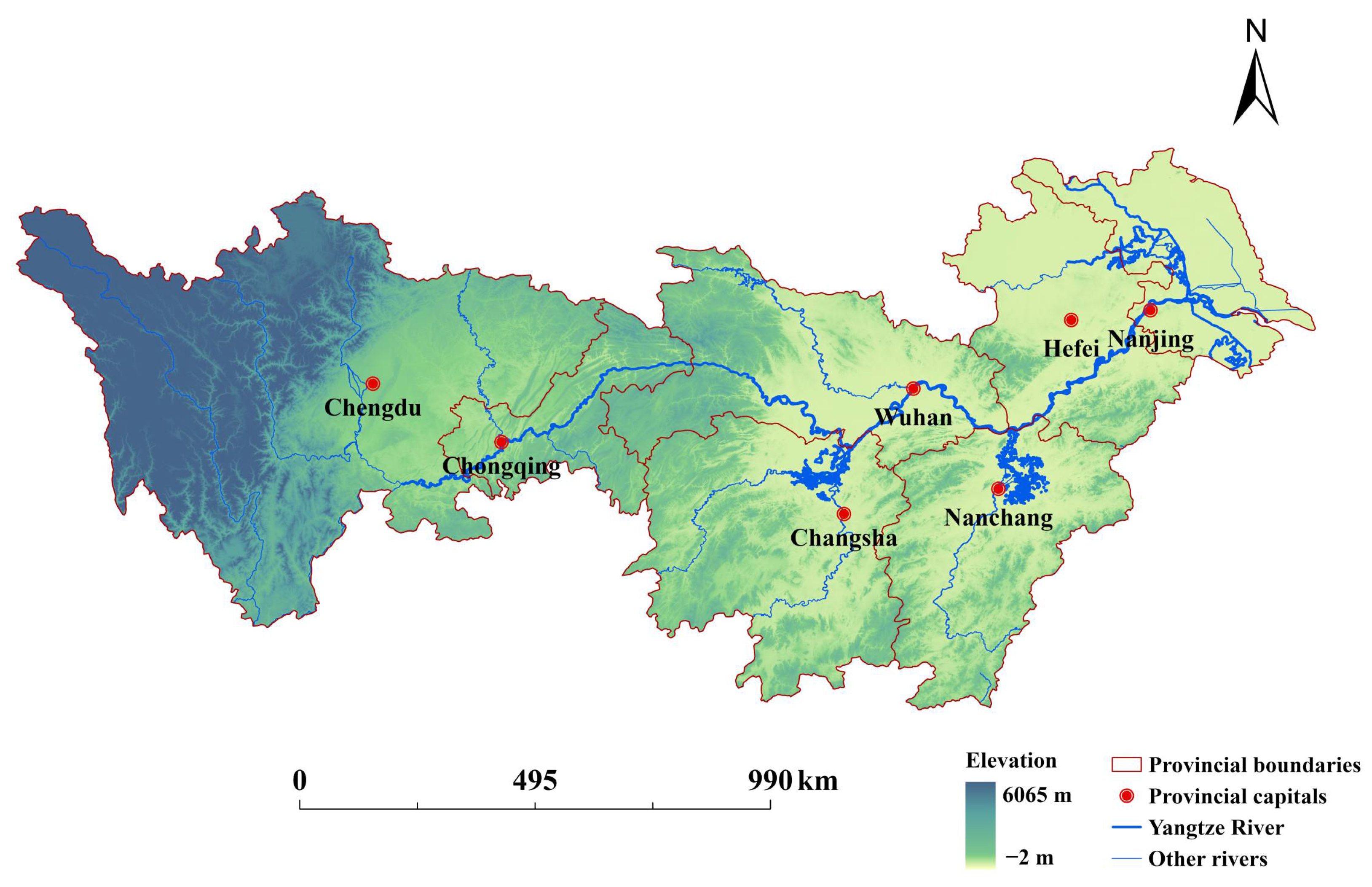
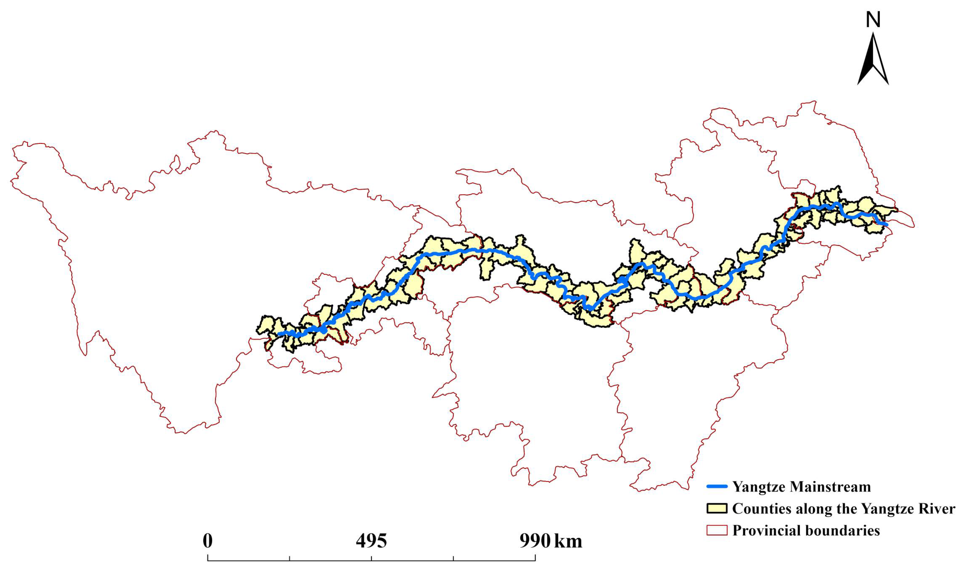
2.1. Study Area
2.2. Data Sources
2.3. Methods
2.3.1. Identification of Urban–Agricultural–Ecological Spaces
2.3.2. The Transfer Matrix of Space Change
2.3.3. Calculation of the Distance Between the Three-Zone Space and the Yangtze River
2.3.4. Optimal-Parameters-Based Geographical Detector (OPGD) Model
3. Results
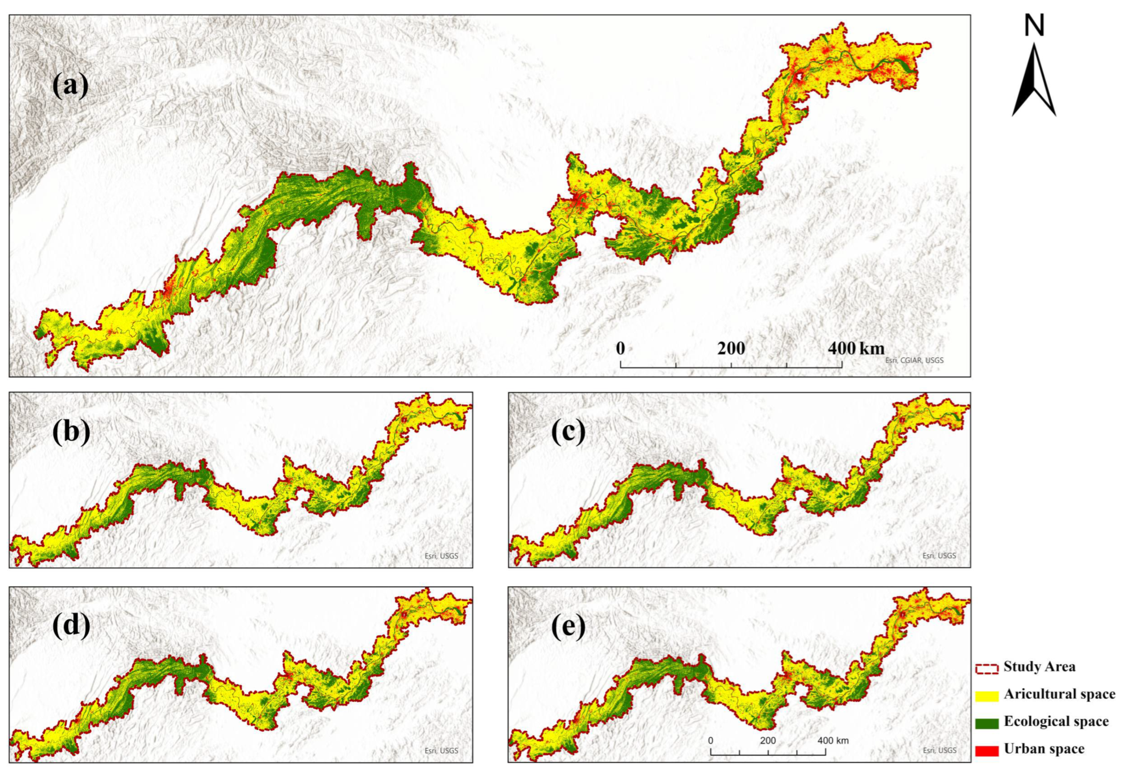
3.1. Distribution Characteristics of Urban–Agricultural–Ecological Space
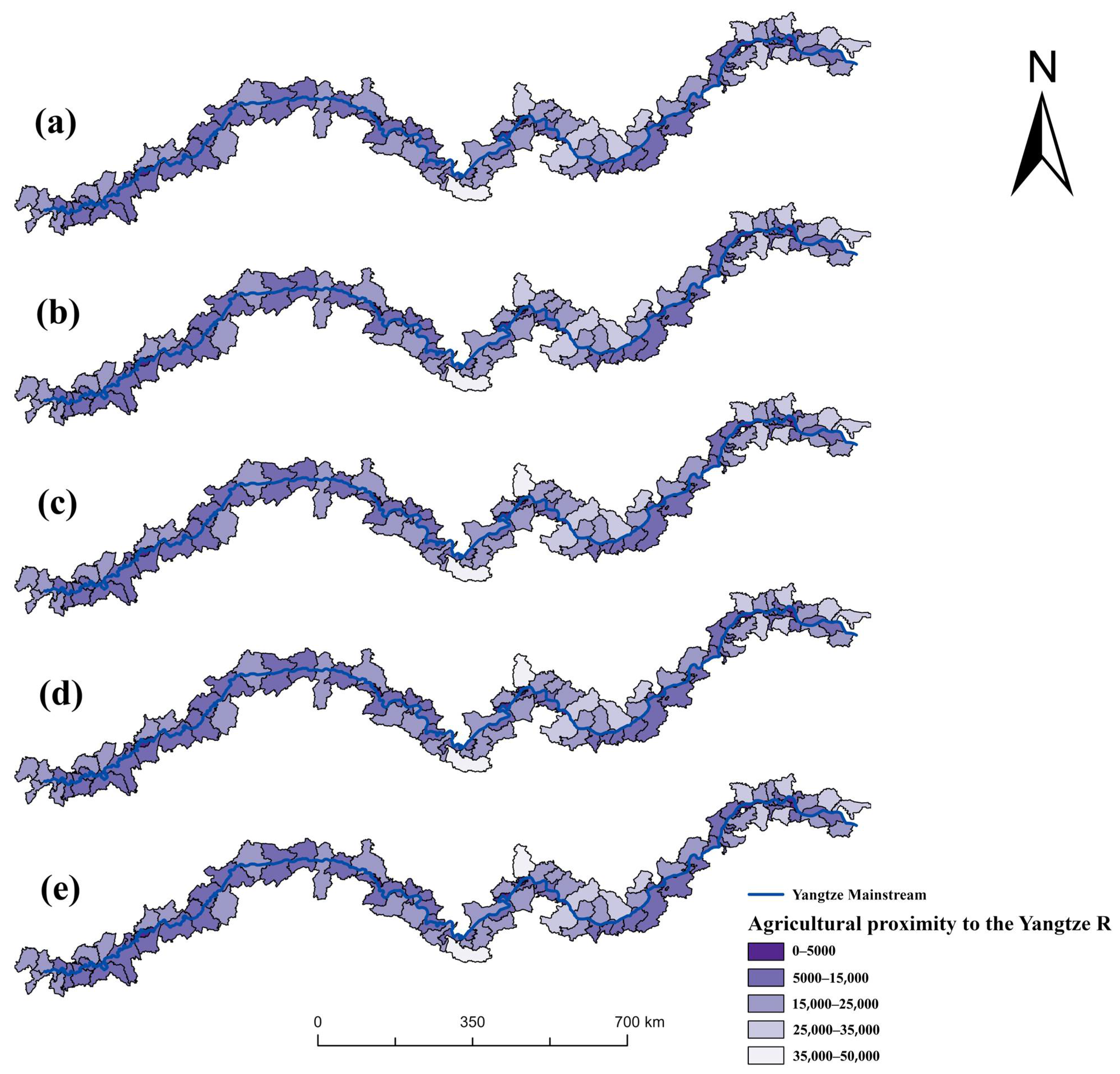
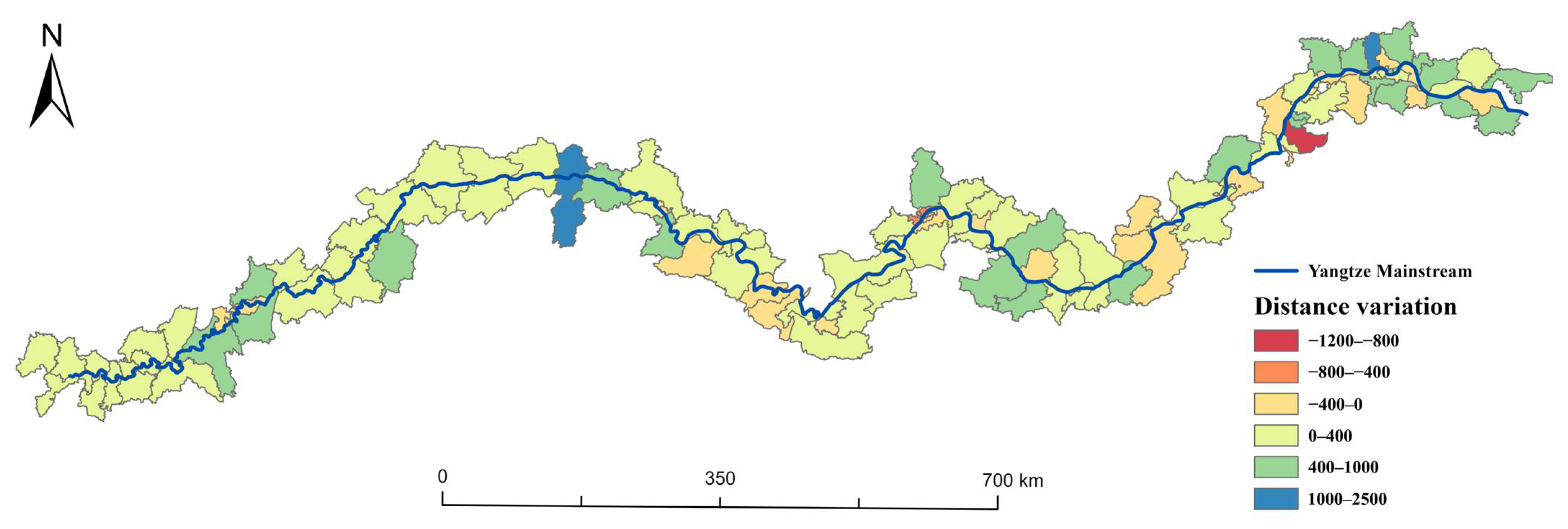
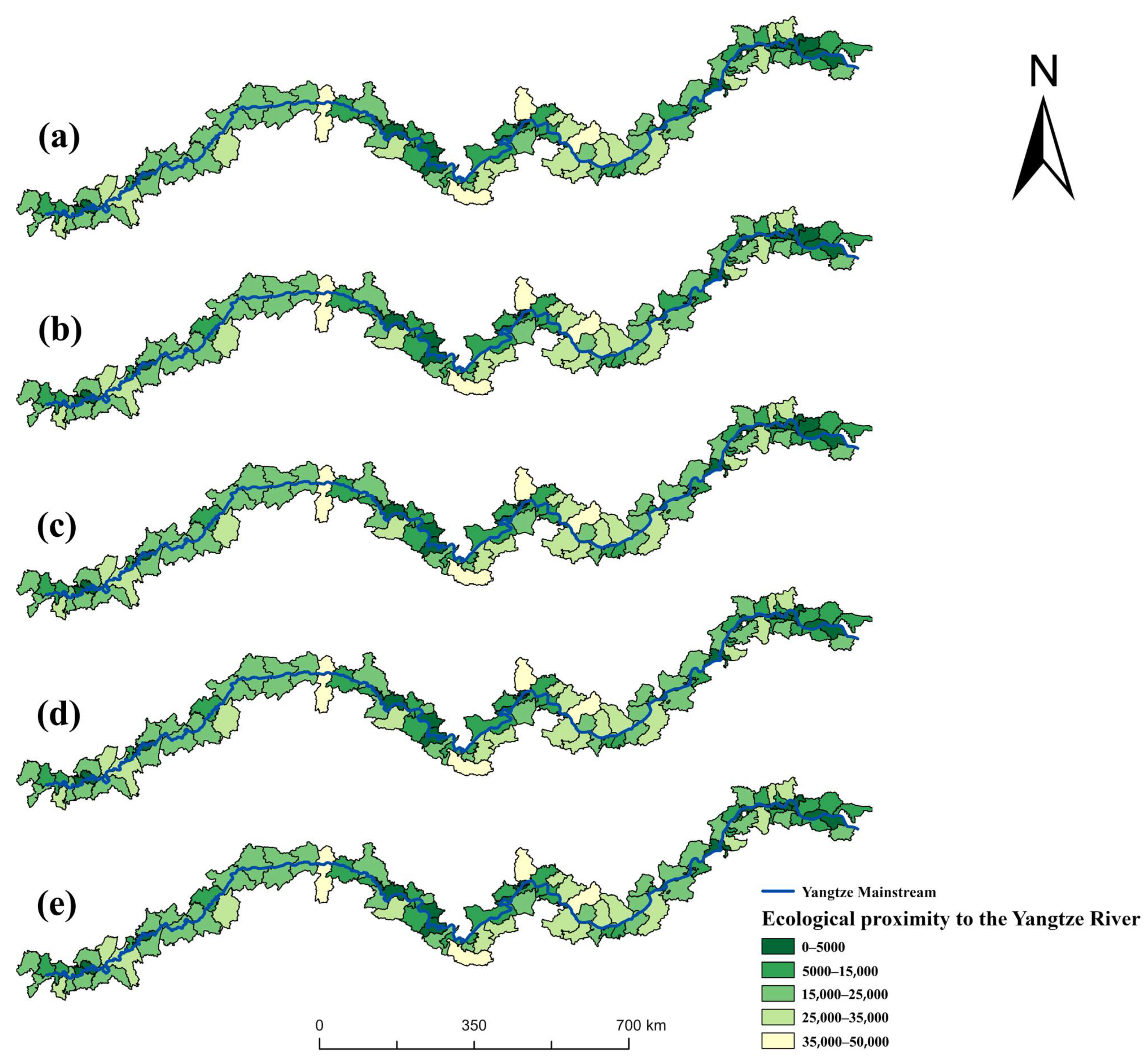
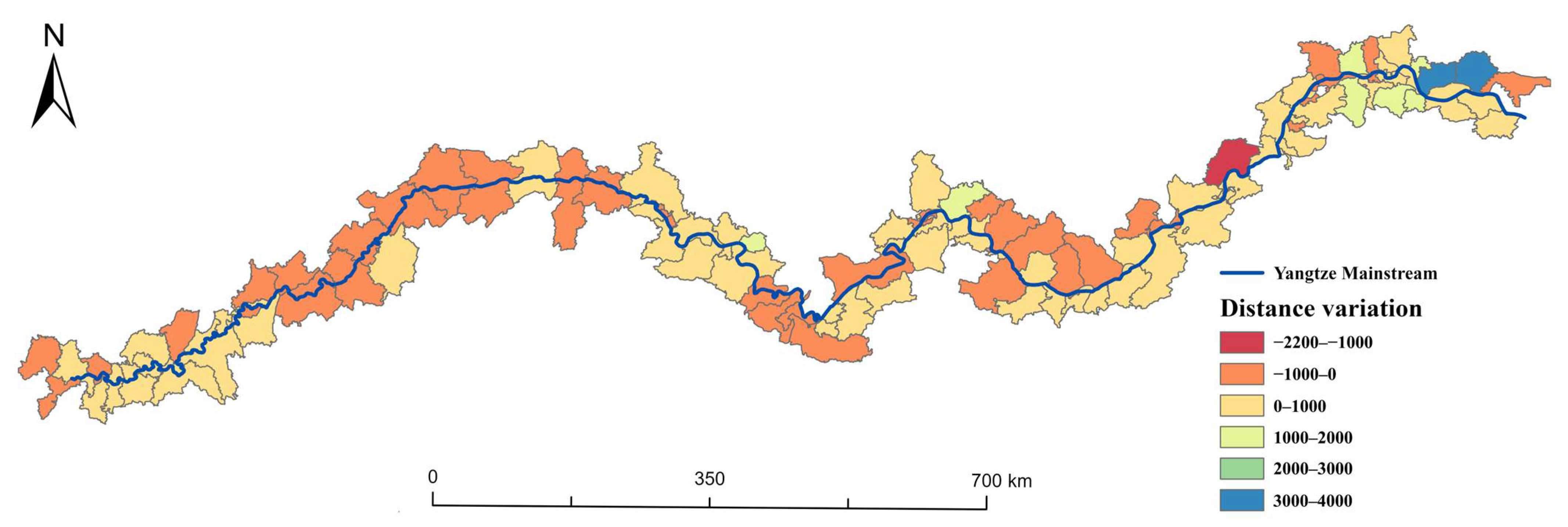
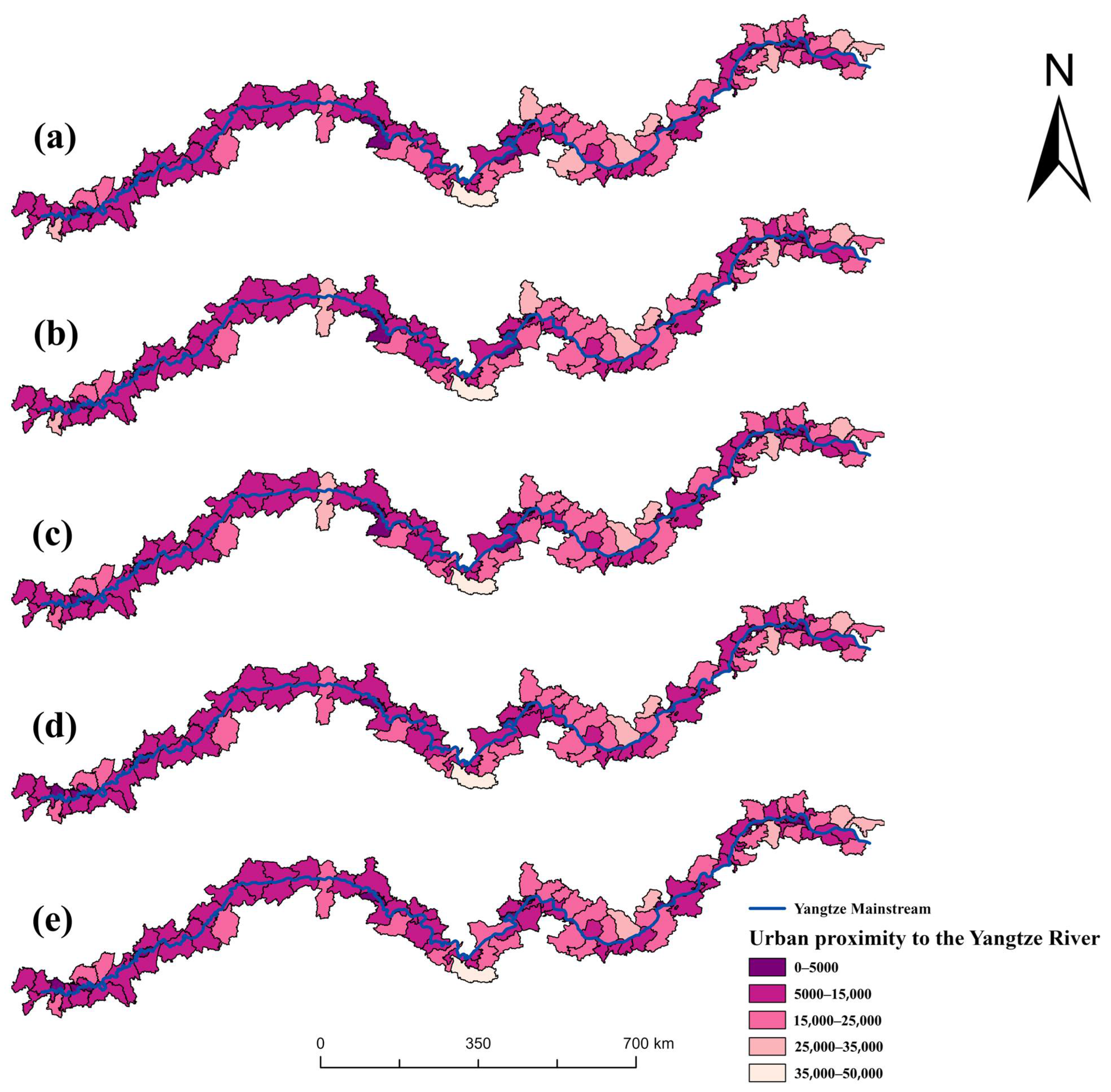
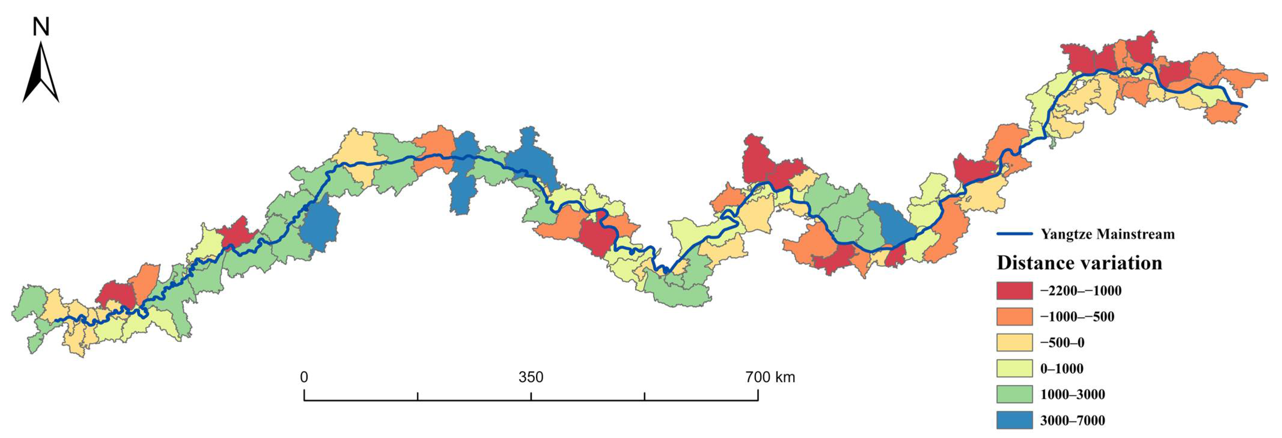
3.2. Spatial–Temporal Variations in the Distance Between the Three-Zone Space and the Yangtze River
3.3. Driving Factors of Changes in Distance Between Three Types of Spaces and the Yangtze River
3.3.1. Single Factor Analysis
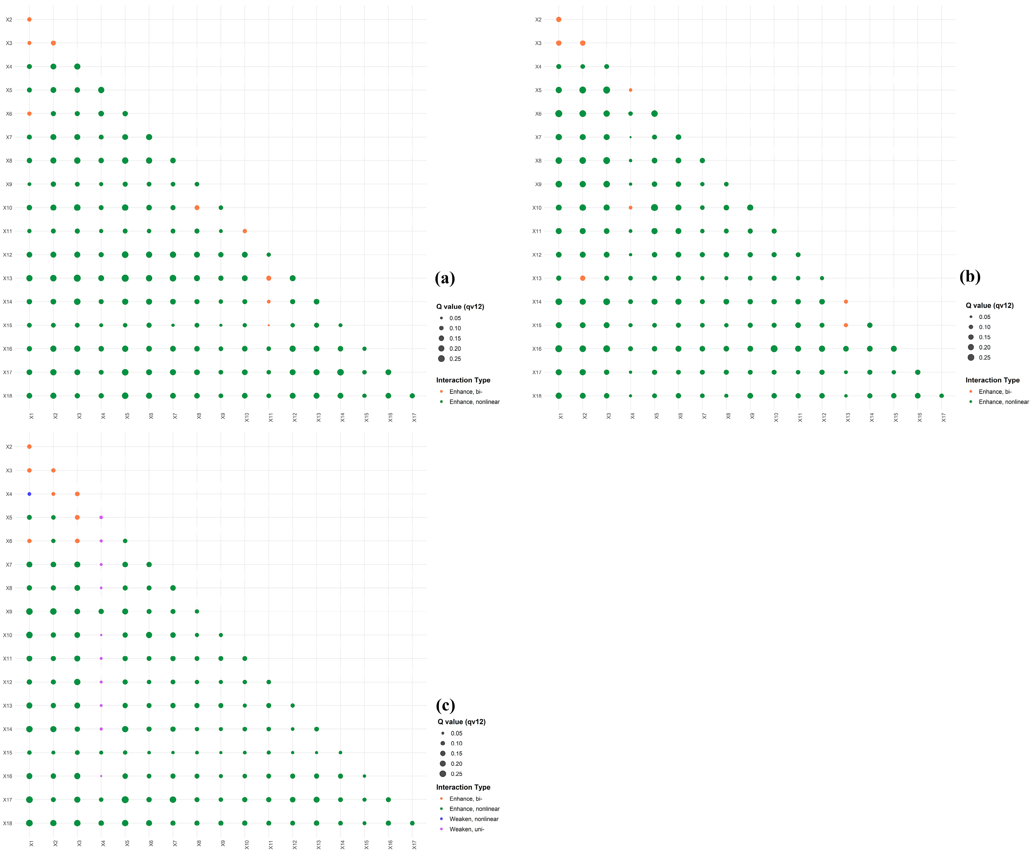
3.3.2. Factor Interaction
4. Discussion
4.1. Land-Scale Transitions and Spatiotemporal Evolution of Distance to the Yangtze River
4.2. Driving Mechanisms of Distance Transitions
4.3. Policy Recommendations
4.4. Limitations
5. Conclusions
Author Contributions
Funding
Data Availability Statement
Conflicts of Interest
References
- Wei, Y.; Wu, S. The gulf of cross-disciplinary research collaborations on global river basins is not narrowed. Ambio 2022, 51, 1994–2006. [Google Scholar] [CrossRef]
- Ou, H.; Cai, S.; Fan, W.; Qiu, J.; Mu, X.; Zhou, T.; Yang, X.; Picco, L. Sustaining the Pearl River: A Critical Review of Changes in Fluvial Geomorphological Processes and the Driving Forces in the Pearl River Basin. Water 2024, 16, 1001. [Google Scholar] [CrossRef]
- Wang, J.; Kumar Shrestha, N.; Aghajani Delavar, M.; Worku Meshesha, T.; Bhanja, S.N. Modelling Watershed and River Basin Processes in Cold Climate Regions: A Review. Water 2021, 13, 518. [Google Scholar] [CrossRef]
- Grabowski, R.C.; Vercruysse, K.; Holman, I.; Azhoni, A.; Bala, B.; Shankar, V.; Beale, J.; Mukate, S.; Poddar, A.; Peng, J.; et al. The land–river interface: A conceptual framework of environmental process interactions to support sustainable development. Sustain. Sci. 2022, 17, 1677–1693. [Google Scholar] [CrossRef]
- Zhang, D.; Song, W.; Chen, N.; Zhang, F. The role of spatial scale in organism–environment positive feedback. Nonlinear Dyn. 2019, 95, 2019–2029. [Google Scholar] [CrossRef]
- Lafuite, A.S.; Loreau, M. Time-delayed biodiversity feedbacks and the sustainability of social-ecological systems. Ecol. Model. 2017, 351, 96–108. [Google Scholar] [CrossRef]
- Mathias, J.-D.; Anderies, J.M.; Baggio, J.; Hodbod, J.; Huet, S.; Janssen, M.A.; Milkoreit, M.; Schoon, M. Exploring non-linear transition pathways in social-ecological systems. Sci. Rep. 2020, 10, 4136. [Google Scholar] [CrossRef]
- Dangerfield, S. The Effects of Sediment Loading on Morphology and Flood Risk in a Lowland River System. Ph.D. Thesis, University of Nottingham, Nottingham, UK, 2013. [Google Scholar]
- Maaß, A.-L.; Schüttrumpf, H.; Lehmkuhl, F. Human impact on fluvial systems in Europe with special regard to today’s river restorations. Environ. Sci. Eur. 2021, 33, 119. [Google Scholar] [CrossRef]
- Garvey, J.E.; Whiles, M.R. Incorporating the riverscape into models of river–floodplain function. Front. Freshw. Sci. 2023, 1, 2023. [Google Scholar] [CrossRef]
- Ciupa, T.; Suligowski, R. Impact of the City on the Rapid Increase in the Runoff and Transport of Suspended and Dissolved Solids During Rainfall—The Example of the Silnica River (Kielce, Poland). Water 2020, 12, 2693. [Google Scholar] [CrossRef]
- Strokal, M.; Bai, Z.; Franssen, W.; Hofstra, N.; Koelmans, A.A.; Ludwig, F.; Ma, L.; van Puijenbroek, P.; Spanier, J.E.; Vermeulen, L.C.; et al. Urbanization: An increasing source of multiple pollutants to rivers in the 21st century. Npj Urban Sustain. 2021, 1, 24. [Google Scholar] [CrossRef]
- Camacho-Valdez, V.; Rodiles-Hernández, R.; Navarrete-Gutiérrez, D.A.; Valencia-Barrera, E. Tropical wetlands and land use changes: The case of oil palm in neotropical riverine floodplains. PLoS ONE 2022, 17, e0266677. [Google Scholar] [CrossRef] [PubMed]
- Zúñiga-Sarango, W.; Gaona, F.P.; Reyes-Castillo, V.; Iñiguez-Armijos, C. Disrupting the Biodiversity–Ecosystem Function Relationship: Response of Shredders and Leaf Breakdown to Urbanization in Andean Streams. Front. Ecol. Evol. 2020, 8, 2020. [Google Scholar] [CrossRef]
- Echeverría-Sáenz, S.; Ugalde-Salazar, R.; Guevara-Mora, M.; Quesada-Alvarado, F.; Ruepert, C. Ecological Integrity Impairment and Habitat Fragmentation for Neotropical Macroinvertebrate Communities in an Agricultural Stream. Toxics 2022, 10, 346. [Google Scholar] [CrossRef]
- Liu, R.; Dong, X.; Zhang, P.; Zhang, Y.; Wang, X.; Gao, Y. Study on the Sustainable Development of an Arid Basin Based on the Coupling Process of Ecosystem Health and Human Wellbeing Under Land Use Change—A Case Study in the Manas River Basin, Xinjiang, China. Sustainability 2020, 12, 1201. [Google Scholar] [CrossRef]
- Chen, R.; Huang, C. Landscape Evolution and It’s Impact of Ecosystem Service Value of the Wuhan City, China. Int. J. Environ. Res. Public Health 2021, 18, 13015. [Google Scholar] [CrossRef]
- Park, S.-R.; Kim, S.; Lee, S.-W. Evaluating the Relationships between Riparian Land Cover Characteristics and Biological Integrity of Streams Using Random Forest Algorithms. Int. J. Environ. Res. Public Health 2021, 18, 3182. [Google Scholar] [CrossRef]
- Liu, C.; Qu, L.; Clausen, J.; Lei, T.; Yang, X. Impact of Riparian Buffer Zone Design on Surface Water Quality at the Watershed Scale, a Case Study in the Jinghe Watershed in China. Water 2023, 15, 2696. [Google Scholar] [CrossRef]
- Jayasuriya, M.T.; Germain, R.H.; Stella, J.C. Applying the “Goldilocks Rule” to Riparian Buffer Widths for Forested Headwater Streams across the Contiguous U.S.—How Much Is “Just Right”? Forests 2022, 13, 1509. [Google Scholar] [CrossRef]
- Ding, H. The Influence of Landforms and Sampling Approaches on Riparian Buffer Area and Complexity. Ph.D. Thesis, Michigan Technological University, Houghton, MI, USA, 2020. [Google Scholar]
- Graziano, M.P.; Deguire, A.K.; Surasinghe, T.D. Riparian Buffers as a Critical Landscape Feature: Insights for Riverscape Conservation and Policy Renovations. Diversity 2022, 14, 172. [Google Scholar] [CrossRef]
- Meng, R.; Cai, J.; Xin, H.; Meng, Z.; Dang, X.; Han, Y. Spatio-Temporal Changes in Land Use and Habitat Quality of Hobq Desert along the Yellow River Section. Int. J. Environ. Res. Public Health 2023, 20, 3599. [Google Scholar] [CrossRef]
- Vera Mercado, J.A.; Engel, B. Multi-Scale Analysis of the Dependence of Water Quality on Land Use Using Linear and Mixed Models. Water 2021, 13, 2618. [Google Scholar] [CrossRef]
- Zhang, M.; Du, H.; Mao, F.; Zhou, G.; Li, X.; Dong, L.; Zheng, J.; Zhu, D.e.; Liu, H.; Huang, Z.; et al. Spatiotemporal Evolution of Urban Expansion Using Landsat Time Series Data and Assessment of Its Influences on Forests. ISPRS Int. J. Geo-Inf. 2020, 9, 64. [Google Scholar] [CrossRef]
- Song, Y.; Zhang, Z.; Li, Y.; Zou, R.; Wang, L.; Yang, H.; Hu, Y. The Role of High Nature Value Farmland for Landscape and Soil Pollution Assessment in a Coastal Delta in China Based on High-Resolution Indicators. Sustainability 2023, 15, 6728. [Google Scholar] [CrossRef]
- Zhong, Y.; Lin, A.; He, L.; Zhou, Z.; Yuan, M. Spatiotemporal Dynamics and Driving Forces of Urban Land-Use Expansion: A Case Study of the Yangtze River Economic Belt, China. Remote Sens. 2020, 12, 287. [Google Scholar] [CrossRef]
- Cui, X.; Cai, T.; Deng, W.; Zheng, R.; Jiang, Y.; Bao, H. Indicators for Evaluating High-Quality Agricultural Development: Empirical Study from Yangtze River Economic Belt, China. Soc. Indic. Res. 2022, 164, 1101–1127. [Google Scholar] [CrossRef] [PubMed]
- Hao, J.; Wang, J.; Zhang, S.; Wu, F.; Jiang, H.; Wu, W.; Liu, N. Several Strategic Issues for the Construction of Ecological Civilization in Yangtze River Economic Belt. Strateg. Study CAE 2022, 24, 141–147. [Google Scholar] [CrossRef]
- Zhang, X.; Zhao, T.; Xu, H.; Liu, W.; Wang, J.; Chen, X.; Liu, L. GLC_FCS30D: The first global 30 m land-cover dynamics monitoring product with a fine classification system for the period from 1985 to 2022 generated using dense-time-series Landsat imagery and the continuous change-detection method. Earth Syst. Sci. Data 2024, 16, 1353–1381. [Google Scholar] [CrossRef]
- Wei, W.; Li, Y.; Bo, X.; Liming, B. Spatial-temporal Evolution Characteristics and Mechanism of “Three-function Space” in the Yellow River Basin Under the Background of Territorial Spatial Planning. Econ. Geogr. 2022, 42, 44–55. [Google Scholar] [CrossRef]
- Zhang, K.; Wei, W.; Zhou, J.; Yin, L.; Xia, J.N. Spatial-temporal Evolution Characteristics and Mechanism of “Three-Function Space” in the Three-Rivers Headwaters’ Region from 1992 to 2020. J. Geo-Inf. Sci. 2022, 24, 1755–1770. [Google Scholar]
- Tomlinson, S.J.; Dragosits, U.; Levy, P.E.; Thomson, A.M.; Moxley, J. Quantifying gross vs. net agricultural land use change in Great Britain using the Integrated Administration and Control System. Sci. Total Environ. 2018, 628-629, 1234–1248. [Google Scholar] [CrossRef] [PubMed]
- Zhang, S.; Shao, H.; Li, X.; Xian, W.; Shao, Q.; Yin, Z.; Lai, F.; Qi, J. Spatiotemporal Dynamics of Ecological Security Pattern of Urban Agglomerations in Yangtze River Delta Based on LUCC Simulation. Remote Sens. 2022, 14, 296. [Google Scholar] [CrossRef]
- Safabakhshpachehkenari, M.; Tonooka, H. Modeling Land Use Transformations and Flood Hazard on Ibaraki’s Coastal in 2030: A Scenario-Based Approach Amid Population Fluctuations. Remote Sens. 2024, 16, 898. [Google Scholar] [CrossRef]
- Chakma, M.; Hayat, U.; Meng, J.; Hassan, M.A. An Assessment of Landscape and Land Use/Cover Change and Its Implications for Sustainable Landscape Management in the Chittagong Hill Tracts, Bangladesh. Land 2023, 12, 1610. [Google Scholar] [CrossRef]
- Li, C.; Wu, J. Land use transformation and eco-environmental effects based on production-living-ecological spatial synergy: Evidence from Shaanxi Province, China. Environ. Sci. Pollut. Res. 2022, 29, 41492–41504. [Google Scholar] [CrossRef] [PubMed]
- Staponites, L.R.; Barták, V.; Bílý, M.; Simon, O.P. Performance of landscape composition metrics for predicting water quality in headwater catchments. Sci. Rep. 2019, 9, 14405. [Google Scholar] [CrossRef]
- Mohd Ali, N.F.; Yunus, R.; Mohamed, I.; Othman, F. Improved Spatial Outlier Detection Method within a River Network. Sains Malays. 2022, 51, 911–927. [Google Scholar] [CrossRef]
- Scherelis, V.; Doering, M.; Laube, P. HydroWidth: A small-scale approach to calculate river width and its variability. Trans. GIS 2023, 27, 1503–1525. [Google Scholar] [CrossRef]
- Arnaud-Fassetta, G.; Melun, G.; Passy, P.; Brousse, G.; Theureaux, O. How to Quantify the Dynamics of Single (Straight or Sinuous) and Multiple (Anabranching) Channels from Imagery for River Restoration. Appl. Sci. 2021, 11, 8075. [Google Scholar] [CrossRef]
- Song, Y.; Wang, J.; Xu, C. An optimal parameters-based geographical detector model enhances geographic characteristics of explanatory variables for spatial heterogeneity analysis: Cases with different types of spatial data. GIScience Remote Sens. 2020, 57, 1–17. [Google Scholar] [CrossRef]
- Lesage, J.; Pace, R.K. Introduction to Spatial Econometrics; Chapman and Hall/CRC: New York, NY, USA, 2008; pp. 19–44. [Google Scholar]
- Xia, J.; Hong, M.; Wei, W. Changes and Driving Forces of Urban–Agricultural–Ecological Space in the Yangtze River Economic Belt from 2000 to 2020. Land 2023, 12, 1014. [Google Scholar] [CrossRef]
- Li, Y.; Wang, S. Exploration of Eco-Environment and Urbanization Changes Based on Multi-Source Remote Sensing Data—A Case Study of Yangtze River Delta Urban Agglomeration. Sustainability 2024, 16, 5903. [Google Scholar] [CrossRef]
- Zhao, J.; Zhao, Y.; Yang, X. Evolution Characteristics and Driving Mechanism of the Territorial Space Pattern in the Yangtze River Economic Belt, China. Land 2022, 11, 1447. [Google Scholar] [CrossRef]
- Hu, Y.; Zhang, Y. Spatial-temporal dynamics and driving factor analysis of urban ecological land in Zhuhai city, China. Sci. Rep. 2020, 10, 16174. [Google Scholar] [CrossRef] [PubMed]
- Tufekcioglu, M.; Schultz, R.C.; Isenhart, T.M.; Kovar, J.L.; Russell, J.R. Riparian Land-Use, Stream Morphology and Streambank Erosion within Grazed Pastures in Southern Iowa, USA: A Catchment-Wide Perspective. Sustainability 2020, 12, 6461. [Google Scholar] [CrossRef]
- Ge, X.J.; Liu, X. Urban Land Use Efficiency under Resource-Based Economic Transformation—A Case Study of Shanxi Province. Land 2021, 10, 850. [Google Scholar] [CrossRef]
- Zheng, D.; Zhang, G.; Shan, H.; Tu, Q.; Wu, H.; Li, S. Spatio-Temporal Evolution of Urban Morphology in the Yangtze River Middle Reaches Megalopolis, China. Sustainability 2020, 12, 1738. [Google Scholar] [CrossRef]
- Cai, W.; Fangyuan, T. Spatiotemporal characteristics and driving forces of construction land expansion in Yangtze River economic belt, China. PLoS ONE 2020, 15, e0227299. [Google Scholar] [CrossRef]
- Slavko, B.; Prokopenko, M.; Glavatskiy, K.S. Diffusive Resettlement: Irreversible Urban Transitions in Closed Systems. Entropy 2021, 23, 66. [Google Scholar] [CrossRef]
- Wei, W.; Jiangbo, M.; Junnan, X.; Jing, W. Spatial-Temporal Evolution Characteristics and Mechanism of “Three-Zone Space” along the Yangtze River Economic Belt in Hubei Province from 2010 to 2017. Econ. Geogr. 2020, 40, 132–142. [Google Scholar] [CrossRef]
- Fanghu, L.; Yinnan, H.; Biao, W. Analysis of logistics capacity, influencing factors and spatial spillover effect in Yangtze River Economic Belt. PLoS ONE 2024, 19, e0303200. [Google Scholar] [CrossRef] [PubMed]
- Xiong, G.; Cao, X.; Hamm, N.A.S.; Lin, T.; Zhang, G.; Chen, B. Unbalanced Development Characteristics and Driving Mechanisms of Regional Urban Spatial Form: A Case Study of Jiangsu Province, China. Sustainability 2021, 13, 3121. [Google Scholar] [CrossRef]
- Furtak, K.; Gawryjołek, K.; Marzec-Grządziel, A.; Niedźwiecki, J. The Influence of Human Agricultural Activities on the Quality of Selected Fluvisols from the Vistula River Valley, Poland—Preliminary Research. Agronomy 2024, 14, 480. [Google Scholar] [CrossRef]
- Naylor, L.A.; Dungait, J.A.J.; Zheng, Y.; Buckerfield, S.; Green, S.M.; Oliver, D.M.; Liu, H.; Peng, J.; Tu, C.; Zhang, G.-l.; et al. Achieving Sustainable Earth Futures in the Anthropocene by Including Local Communities in Critical Zone Science. Earth’s Future 2023, 11, e2022EF003448. [Google Scholar] [CrossRef]
- Wang, Y.; Li, H.; Shi, Y.; Yao, Q. A Study on Spatial Accessibility of the Urban Stadium Emergency Response under the Flood Disaster Scenario. Sustainability 2022, 14, 17041. [Google Scholar] [CrossRef]
- Zhao, Q.; Wang, A.; Jing, Y.; Zhang, G.; Yu, Z.; Yu, J.; Liu, Y.; Ding, S. Optimizing Management Practices to Reduce Sediment Connectivity between Forest Roads and Streams in a Mountainous Watershed. Remote Sens. 2022, 14, 4897. [Google Scholar] [CrossRef]
- Shi, H.; Shi, T.; Yang, Z.; Wang, Z.; Han, F.; Wang, C. Effect of Roads on Ecological Corridors Used for Wildlife Movement in a Natural Heritage Site. Sustainability 2018, 10, 2725. [Google Scholar] [CrossRef]
- Wang, X.; Wang, X.; Jin, X.; Kou, L.; Hou, Y. Evaluation and driving force analysis of ecological environment in low mountain and hilly regions based on optimized ecological index. Sci. Rep. 2024, 14, 24570. [Google Scholar] [CrossRef]
- Zhang, R.; Zhang, X. Distribution Characteristics and Influencing Factors of Rural Settlements in Metropolitan Fringe Area: A Case Study of Nanjing, China. Land 2022, 11, 1989. [Google Scholar] [CrossRef]
- Qiu, B.; Li, H.; Tang, Z.; Chen, C.; Berry, J. How cropland losses shaped by unbalanced urbanization process? Land Use Policy 2020, 96, 104715. [Google Scholar] [CrossRef]
- Liu, T.; Ren, C.; Zhang, S.; Yin, A.; Yue, W. Coupling Coordination Analysis of Urban Development and Ecological Environment in Urban Area of Guilin Based on Multi-Source Data. Int. J. Environ. Res. Public Health 2022, 19, 12583. [Google Scholar] [CrossRef] [PubMed]
- Zhu, Y.; Ling, G.H.T. A Systematic Review of Morphological Transformation of Urban Open Spaces: Drivers, Trends, and Methods. Sustainability 2022, 14, 10856. [Google Scholar] [CrossRef]
- Zhang, Z.; Jing, W.; Li, H.; Tao, C.; Zhang, Y. GFCNet: Contrastive Learning Network with Geography Feature Space Joint Negative Sample Correction for Land Cover Classification. Remote Sens. 2023, 15, 5056. [Google Scholar] [CrossRef]
- Cerbelaud, A.; Blanchet, G.; Roupioz, L.; Breil, P.; Briottet, X. Mapping Pluvial Flood-Induced Damages with Multi-Sensor Optical Remote Sensing: A Transferable Approach. Remote Sens. 2023, 15, 2361. [Google Scholar] [CrossRef]
- Shukla, T.; Tang, W.; Trettin, C.C.; Chen, G.; Chen, S.; Allan, C. Quantification of Microtopography in Natural Ecosystems Using Close-Range Remote Sensing. Remote Sens. 2023, 15, 2387. [Google Scholar] [CrossRef]
- Torgersen, C.E.; Le Pichon, C.; Fullerton, A.H.; Dugdale, S.J.; Duda, J.J.; Giovannini, F.; Tales, É.; Belliard, J.; Branco, P.; Bergeron, N.E.; et al. Riverscape approaches in practice: Perspectives and applications. Biol. Rev. Camb. Philos. Soc. 2022, 97, 481–504. [Google Scholar] [CrossRef]
- van den Bergh, J.; Castro, J.; Drews, S.; Exadaktylos, F.; Foramitti, J.; Klein, F.; Savin, I. Designing an effective climate-policy mix: Accounting for instrument synergy. Clim. Policy 2021, 21, 745–764. [Google Scholar] [CrossRef]
- Summers, J.K.; Sanderson, R.; Trahan, R.; Hendricks, K.; Ruffin, M.; Williams, A.; Lamper, A.; Lowery, M.; Harwell, L.C. Development of Community-Level Capacity of Resilience to Natural Hazards for Environmental- and Social-Justice-Challenged Communities: 1. Approach, Concepts, and Assessment of Existing Information. Sustainability 2024, 16, 963. [Google Scholar] [CrossRef]
| Three-Zone Space | GLC_FCS30D Land Use Classification System | |
|---|---|---|
| Primary Land Use Category | Secondary Land Use Category | |
| Agricultural Space | Cropland | Includes dryland farming, turf-covered land, and irrigated farmland |
| Ecological Space | Forest | Includes open evergreen broadleaf forest, closed evergreen broadleaf forest, open deciduous broadleaf forest, closed deciduous broadleaf forest, open evergreen needleleaf forest, and closed evergreen needleleaf forest |
| Shrubland | Includes deciduous shrubland and evergreen shrubland | |
| Grassland | Grassland | |
| Water Body | Water Body | |
| Wetlands | Wetlands | |
| Snow and Ice | Permanent snow or ice | |
| Urban Space | Bare Land | Includes sparse vegetation and bare land |
| Impervious Surfaces | Impervious surfaces | |
| Factor Dimension | Driving Factors | Data Source | |
|---|---|---|---|
| Natural conditions | X1 | Average Elevation (m) | Calculate the mean of DEM data within the statistical area |
| X2 | Average Slope (°) | Convert the DEM data into SLOPE data and calculate the average slope of the statistical area | |
| X3 | Elevation Range (°) | Calculate the range of DEM data within the statistical area | |
| X4 | Area (m2) | Obtained from statistical yearbooks spanning the period from 2000 to 2020 | |
| Location | X5 | Distance to provincial capital city (m) | Calculate the average distance from the statistical area to the provincial capitals |
| X6 | Distance to prefecture-level city center (m) | Calculate the average distance from the statistical area to prefecture-level urban centers | |
| Socioeconomic factors | X7 | Change in population size (people) | Calculate the interpolation of the statistical yearbook data for the period of 2000–2020 in the statistical area. |
| X8 | Change in agricultural population size | ||
| X9 | Change in total power of agricultural machinery (104 kWh) | ||
| X10 | Change in value added of primary industry (CNY) | ||
| X11 | Change in value added of secondary industry (CNY) | ||
| X12 | Change in per capita GDP (CNY) | ||
| X13 | Change in government tax revenue (CNY) | ||
| X14 | Change in local government general budget expenditure (CNY) | ||
| X15 | Change in total crop sown area (m2) | ||
| X16 | Change in total grain production (t) | ||
| X17 | Change in the share of value added by the primary industry (%) | ||
| X18 | Change in the share of value added by the secondary industry (%) |
| Year | Urban Space | Agricultural Space | Ecological Space | Proportion |
|---|---|---|---|---|
| 2000 | 4791 | 92,719 | 55,628 | 0.03:0.61:0.36 |
| 2005 | 5876 | 91,193 | 56,069 | 0.04:0.60:0.37 |
| 2010 | 7503 | 88,000 | 57,636 | 0.05:0.57:0.38 |
| 2015 | 9439 | 86,799 | 56,900 | 0.06:0.57:0.37 |
| 2020 | 10,722 | 85,801 | 56,615 | 0.07:0.56:0.37 |
| Time Interval | Transformation Type | |||||
|---|---|---|---|---|---|---|
| A → E | A → U | E → A | E → U | U → A | U → E | |
| 2000–2005 | 3558.0 | 1018.6 | 3049.0 | 155.9 | 1.2 | 87.7 |
| 2005–2010 | 4312.2 | 1515.5 | 2634.3 | 188.6 | 0.6 | 77.1 |
| 2010–2015 | 3466.2 | 1883.7 | 4147.7 | 164.8 | 0.7 | 111.2 |
| 2015–2020 | 3322.4 | 1199.9 | 3524.1 | 126.4 | 1.0 | 42.7 |
| Away from Yangtze | Closer to Yangtze | |||
|---|---|---|---|---|
| Adcode | Change(m) | Adcode | Change(m) | |
| Agricultural space | 422823 | 1305.85 | 340521 | −679.24 |
| 340504 | 615.39 | 420103 | −496.27 | |
| 321003 | 607.26 | 320105 | −489.94 | |
| 340503 | 590.55 | 340503 | −479.39 | |
| 420222 | 495.97 | 420106 | −471.65 | |
| 500112 | 492.21 | 340826 | −412.75 | |
| 320612 | 456.36 | 430602 | −376.07 | |
| 500116 | 452.66 | 420102 | −333.86 | |
| 421126 | 450.77 | 500103 | −329.31 | |
| 420106 | 392.76 | 420105 | −326.18 | |
| Ecological space | 321283 | 2032.08 | 320612 | −2181.66 |
| 421024 | 1457.55 | 340281 | −862.70 | |
| 320682 | 1294.92 | 421024 | −556.87 | |
| 321183 | 996.74 | 321012 | −544.47 | |
| 321181 | 977.12 | 320411 | −527.05 | |
| 320411 | 961.50 | 420103 | −516.90 | |
| 320612 | 887.84 | 321003 | −510.41 | |
| 421002 | 695.01 | 340826 | −460.21 | |
| 321203 | 689.57 | 420105 | −422.26 | |
| 321012 | 628.30 | 421127 | −381.56 | |
| Urban space | 422823 | 8263.21 | 360481 | −1895.73 |
| 500240 | 2710.11 | 511523 | −1524.54 | |
| 340826 | 1823.64 | 511524 | −1522.50 | |
| 420581 | 1700.51 | 510521 | −1437.95 | |
| 420506 | 1589.46 | 422823 | −1424.78 | |
| 511523 | 1560.23 | 341721 | −1422.06 | |
| 510521 | 1501.52 | 500115 | −1381.85 | |
| 421126 | 1390.06 | 320612 | −1310.18 | |
| 511504 | 1310.43 | 340722 | −1295.48 | |
| 511524 | 1191.42 | 421022 | −1282.92 | |
| Agricultural Distance | Ecological Distance | Urban Distance | |
|---|---|---|---|
| X1 | 0.04 * | 0.08 *** | 0.07 *** |
| X2 | 0.06 *** | 0.09 *** | 0.06 ** |
| X3 | 0.06 ** | 0.07 *** | 0.09 *** |
| X4 | 0.05 ** | 0.02 | 0.07 *** |
| Avg. | 0.06 | 0.06 | 0.07 |
| X5 | 0.07 *** | 0.04 ** | 0.05 ** |
| X6 | 0.06 *** | 0.06 *** | 0.04 ** |
| Avg. | 0.07 | 0.05 | 0.05 |
| X7 | 0.04 * | 0.01 | 0.02 |
| X8 | 0.06 *** | 0.02 | 0.03 |
| X9 | 0.03 | 0.01 | 0.01 |
| X10 | 0.06 *** | 0.05 ** | 0.02 |
| X11 | 0.03 | 0.02 | 0.04 * |
| X12 | 0.05 ** | 0.03 | 0.01 |
| X13 | 0.10 *** | 0.05 ** | 0.02 |
| X14 | 0.04 ** | 0.04 ** | 0.03 * |
| X15 | 0.01 | 0.05 ** | 0.01 |
| X16 | 0.04 * | 0.08 ** | 0.03 * |
| X17 | 0.06 *** | 0.02 | 0.04 * |
| X18 | 0.05 ** | 0.01 | 0.04 ** |
| Avg. | 0.05 | 0.03 | 0.03 |
Disclaimer/Publisher’s Note: The statements, opinions and data contained in all publications are solely those of the individual author(s) and contributor(s) and not of MDPI and/or the editor(s). MDPI and/or the editor(s) disclaim responsibility for any injury to people or property resulting from any ideas, methods, instructions or products referred to in the content. |
© 2025 by the authors. Licensee MDPI, Basel, Switzerland. This article is an open access article distributed under the terms and conditions of the Creative Commons Attribution (CC BY) license (https://creativecommons.org/licenses/by/4.0/).
Share and Cite
Aishanjiang, J.; Li, X.; Qiu, F.; Jia, Y.; Li, K.; Xia, J. Spatiotemporal Evolution and Proximity Dynamics of “Three-Zone Spaces” in Yangtze River Basin Counties from 2000 to 2020. Land 2025, 14, 1380. https://doi.org/10.3390/land14071380
Aishanjiang J, Li X, Qiu F, Jia Y, Li K, Xia J. Spatiotemporal Evolution and Proximity Dynamics of “Three-Zone Spaces” in Yangtze River Basin Counties from 2000 to 2020. Land. 2025; 14(7):1380. https://doi.org/10.3390/land14071380
Chicago/Turabian StyleAishanjiang, Jiawuhaier, Xiaofen Li, Fan Qiu, Yichen Jia, Kai Li, and Junnan Xia. 2025. "Spatiotemporal Evolution and Proximity Dynamics of “Three-Zone Spaces” in Yangtze River Basin Counties from 2000 to 2020" Land 14, no. 7: 1380. https://doi.org/10.3390/land14071380
APA StyleAishanjiang, J., Li, X., Qiu, F., Jia, Y., Li, K., & Xia, J. (2025). Spatiotemporal Evolution and Proximity Dynamics of “Three-Zone Spaces” in Yangtze River Basin Counties from 2000 to 2020. Land, 14(7), 1380. https://doi.org/10.3390/land14071380


