Article

The Impact of Grassland Fires on the Archaeological Record—A Case Study Along the Eastern Escarpment of the Southern High Plains of Texas

1
Heritage and Museum Sciences, Texas Tech University, Museum of Texas Tech, Campus Box 43191, Lubbock, TX 79409, USA
2
Lubbock Lake Landmark, 2401 Landmark Drive, Lubbock, TX 79415, USA
*
Author to whom correspondence should be addressed.
Land 2025, 14(7), 1364; https://doi.org/10.3390/land14071364
Submission received: 16 April 2025 / Revised: 6 June 2025 / Accepted: 25 June 2025 / Published: 28 June 2025

Abstract

Fires are an essential aspect of the grassland ecosystem across the Great Plains of North America. Wildfires can also transform surrounding rocks to appear like hearths or hearthstones used by prehistoric people. A grassland fire that swept through part of a historic ranch located along the eastern escarpment of the Southern High Plains of Texas has created surface features that mimicked the appearance of hearths. Fourteen wildfire features resembling hearths have been documented, and thermally modified rocks from the surface of three of these features were analyzed to investigate the impact of natural fires on the landscape. The results demonstrate that wildfires can create features resembling hearths when an adjacent shrub is burned. An excavation and detailed analysis, however, suggest that (1) the tops of thermally modified rocks from a wildfire will often have a relatively darker Munsell color value in comparison to their bottom halves, and (2) wildfire features will likely have a thinner cross-section of ash and larger pieces of charcoal produced from the incomplete combustion of the nearby shrub and deadfall. The broader implications are useful for understanding site formation processes within temperate grassland settings in other places.

1. Introduction

Anthropogenic thermal features are among the most significant archeological features on a global basis [1,2]. Thermal features can provide a time capsule that documents early human behavior [3,4,5] and offer insights into past diet, landscape use strategies, and daily activities [6,7]. Surrounding rock is often used in hearths to reduce fuel consumption and moderate temperature fluctuations [8,9]. Thermally modified rock, therefore, is one of the most widespread and abundant culturally modified materials [10,11]. Stone-lined hearths with multiple layers of ash and charcoal directly associated with other cultural material objects can provide clear evidence of human-controlled fire [12]. Distinguishing between anthropogenic and natural fires, however, can be challenging if the thermal features are not stone-built and other cultural contextual clues are absent [5,12].
Studies have been conducted to differentiate thermal features produced by wildfires from those of anthropogenic origin (e.g., [5,12,13,14,15,16,17]). That research has sought to evaluate the impact of fire on physical evidence of human-induced thermal features and artifacts, such as thermally modified rock [11], bone [18,19,20,21,22], stone tools and debitage [23], ash and charcoal production [24], and the rubefication of the underlying sediment [25,26,27]. The findings have indicated that natural wildfires typically do not reach temperatures and durations sufficient to alter material culture to the same extent as when the material culture is associated with an anthropogenic hearth.
Experimental studies have demonstrated consistently that controlled fire is essential to achieve the temperatures necessary for complete discoloration of hearthstones [8,28,29,30]. Research on fracturing rates of rocks has indicated that the material type of the rock and its rapid exposure to heating and cooling are the most influential factors in determining the rate and type of fractures produced [8,11,28,31]. Conversely, natural fires usually only discolor the upper surfaces of rocks, and fracturing is more limited [8,28].
Cutts et al. [23] identified Thermal Curved-Fragments (TCFs) as diagnostic of anthropogenetic fires. These TCFs were produced from knappable lithic material when exposed to high temperatures, and have a curvilinear detachment shape with no conchoidal fracture features. Backhouse and Johnson [28] also noted similar objects to TCFs in experiments using Potter member quartzarenite (referred to as quartzite in the literature) as hearthstones. Cutts et al. [23] found that TCFs are produced when the lithic material is exposed to temperatures exceeding 550 °C for two or more hours and that the surface temperature of natural fires does not produce a high enough heat or long enough period of time to produce TCFs.
The amount, type of fuel, and depth of basin construction dictate the amount of charcoal and ash production. Experiments have indicated that fires built inside a depression have a relatively high thermal efficiency compared to flat open burn areas [12]. Protected environments lead to more complete combustion, leading to a higher production of ash and smaller amounts of charcoal [27]. Spatially constrained fires will lead to a substantial rise in the temperatures of the deposits directly underlying them, with temperatures decreasing dramatically to their edges [25]. The most significant changes occur within the first two to three hours of heating, with a relatively short-lived fire event having the potential to alter underlying deposits and leave traces that can be discernable archeologically (e.g., burned artifacts or rubefication) [25].
Bellomo [3] documented the impact on the archeological record of natural fires burning tree stumps. Tree stumps burned during a natural fire can modify surrounding rocks thermally and leave behind a hole filled with unconsolidated sediment. The temperatures reached in tree stump burning, however, were still lower (250 °C/482 °F) than those found in an anthropogenic hearth (600 °C/1112 °F). The bark that fell off the tree while burning acted as an insulator and reduced the heat transferred to the surrounding sediment. As a result, a tree stump fire did not result in complete combustion, and larger pieces of charcoal were produced.
The archeological record of the Southern High Plains and surrounding regions is shaped predominantly by hunter-gatherer occupations [32,33]. Thermal features such as hearths and baking ovens are among the most visible indicators of these occupations, typically associated with ephemeral campsites where fire played a central role in daily subsistence and social practices. These features are encountered both on the surface and through subsurface excavation and are highly susceptible to a range of site formation processes that affect their integrity and visibility.
Backhouse [34] conducted a detailed analysis of the spatial and temporal distribution of thermal features in the region, illustrating that fire technology is widely represented in the archeological record. His study highlights how both cultural behaviors and taphonomic processes—including erosion and natural grassland fires—have shaped the preservation and distribution of these features, occasionally obscuring or mimicking their anthropogenic origins.
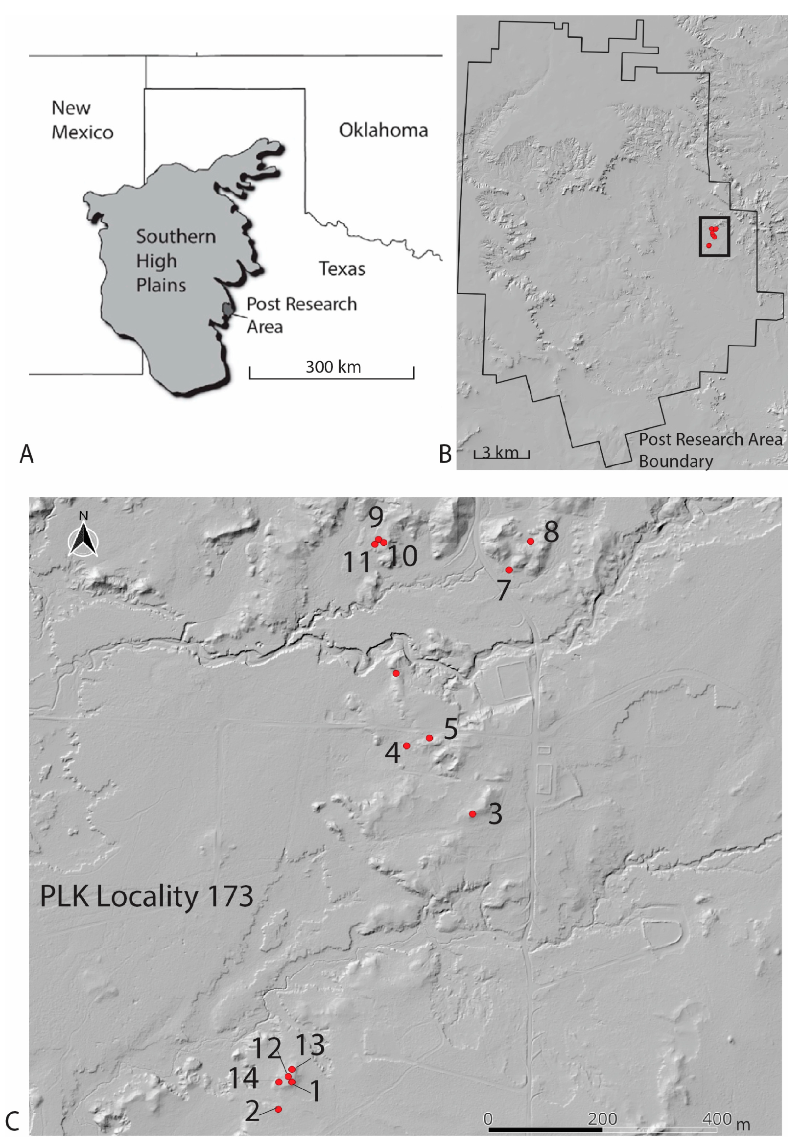
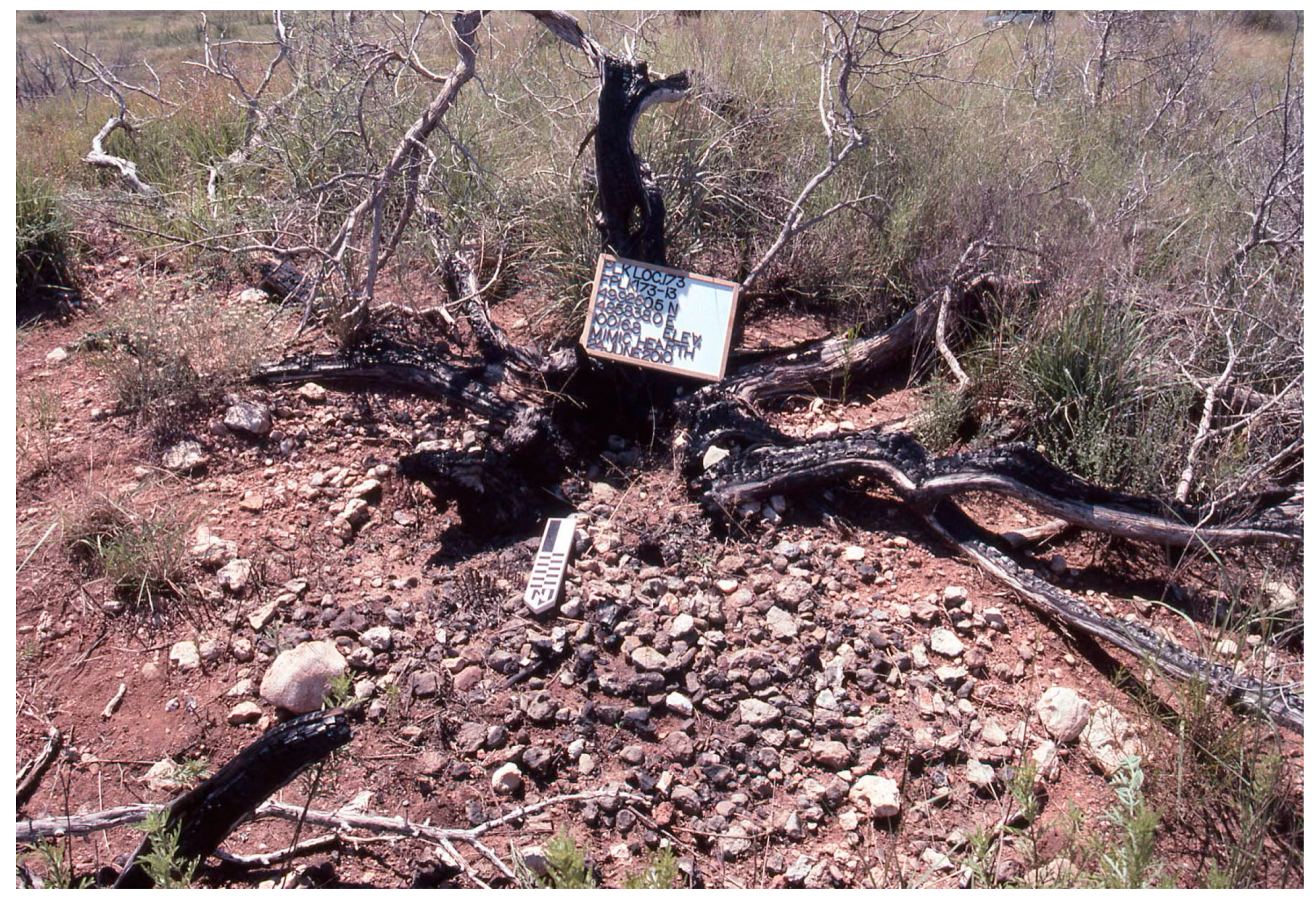
Fourteen thermal features generated by a natural wildfire that occurred between 17 and 18 April 2008, have been identified on a historic ranch located near Post, Texas (Figure 1). These thermal features are located on high points where natural rocks, commonly used in hearths, are concentrated. In areas with caliche nodules, sandstone, or other gravels associated with shrubs, the naturally occurring rock has been modified and cracked due to the fire (Figure 2). In addition, charred wood and charcoal from the 2008 fire remained visible, partially covered by new grass that had grown over the past two years.
In the future, these mimic hearths could possibly be misidentified as anthropogenic thermal features after the shrub remnants erode away and only charcoal and thermally modified rocks remain.
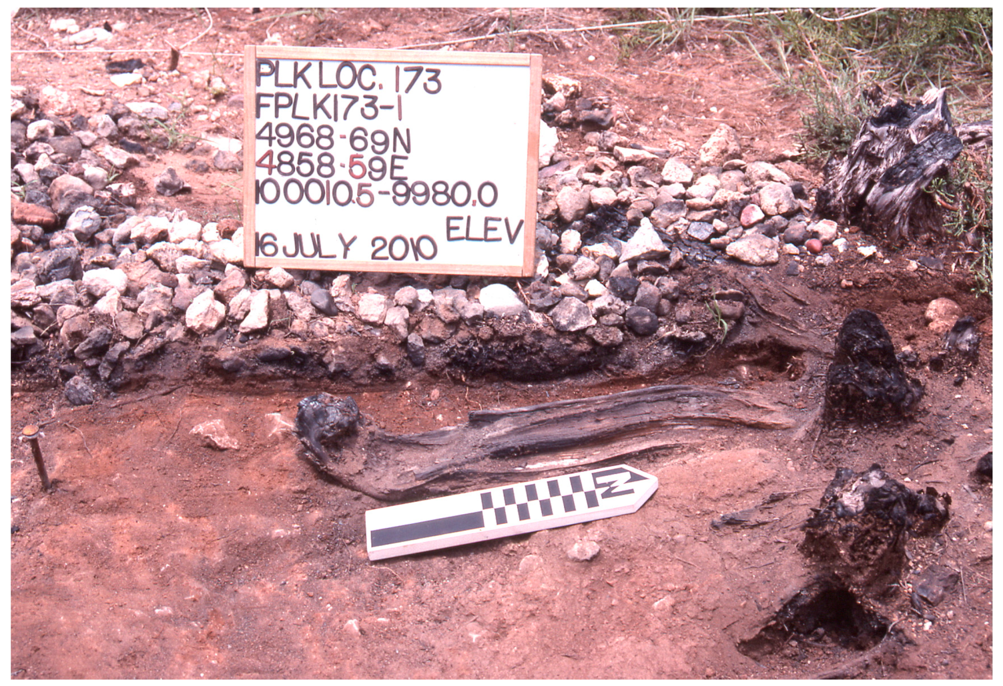
Fieldwork at the site was conducted between 17 June and 16 July 2010, during which time the research team conducted systematic documentation. Although the wildfire lasted two days, neither the duration of the fire in the specific area of the natural features nor the temperatures reached were known as the wildfire was not monitored. The 14 thermal features that mimicked the appearance of cultural hearths on the surface were mapped and photographed. An excavation and hearthstone analysis methodology [8,28] was employed to examine 3 of the 14 recorded thermal features. One of those three was excavated to document the morphology of the feature.
The presence of thermal features is crucial in the archeological record. It is essential to differentiate between cultural thermal features and those resulting from natural wildfires. Researchers must comprehend fully the formation processes of natural and cultural thermal features within the archeological record to interpret accurately the past. The results from this study will further elucidate the impact of natural wildfires on thermally modifying rocks and the production of surrounding ash and charcoal from shrub burning.

2. Background

2.1. Landscape Setting

Situated within the southern portion of the Great Plains physiographic region, the historic ranch (335 km2 in extent) constitutes the Post research area that is located at the topographic boundary between the Southern High Plains (Llano Estacado) and the Central Lowlands (Rolling Plains) (Figure 1) [35]. The landscape of the upland Southern High Plains is a flat, expansive plateau, with 25,000 small lake basins (freshwater playas) and 40 saline depressions (brackish salinas) present [36].
Several large dune fields are found throughout the Southern High Plains, while northwest-to-southeast-trending river valleys (draws) are tributaries of the Red, Brazos, and Colorado rivers. The region has formed as a result of the aggradation of the Ogallala Formation (Miocene–Pliocene), with the Blackwater Draw Formation (early Pleistocene to ~50,000 years ago) providing a thick mantle of aeolian sediments [37]. The Ogallala Formation basal gravels are a regional rock source available locally wherever a section of a paleovalley is exposed [38,39]. The highly resistant pedogenic calcrete at the top of the Ogallala Formation is ledge-forming, breaks off in thick blocky sections, and is a major source of caliche [39,40,41].
In contrast to the flat Southern High Plains, the Rolling Plains has a low relief (30 to 100 m) with hilly landforms caused by the incision and erosion of the differentially resistant Triassic and Permian-age sandstone bedrock [40]. The north–south geomorphic divide between the Southern High Plains and the Rolling Plains (the Southern High Plains eastern escarpment) is rugged, providing a concentration of resources that would have enticed hunter-gatherer groups to camp along the escarpment. That escarpment exposes the Ogallala Formation with its basal gravels and caliche sources. Further, the escarpment has been eroding in a western retreat over the millions of years exposing the current surface of the westernmost Rolling Plains and investigation area around 35 thousand years ago [42]. The erosion has left lag deposits of Ogallala Formation gravels and caliche on the westernmost Rolling Plains surface [28]. That stripping of the Ogallala Formation has allowed the subsequent exposure of Triassic-age sandstone [43].
The Southern High Plains were characterized by extensive grasslands throughout the Quaternary period [44,45,46,47,48]. The short-grass ecosystem began to emerge approximately 8000 years ago and is distinguished by grass types such as buffalo grass and blue grama. Native trees and shrubs constitute part of the vegetation and exhibit a distinct distribution pattern [45,48,49,50,51,52,53]. Woody plants were found intermittently in draws, reentrant canyons, and escarpments, often near water sources such as seeps, springs, streams, ponds, and marshes. Trees such as hackberry, Texas walnut, mesquite, and cottonwood were typically found in the draws, while wild plum, piñon-pine, and juniper are more likely to be found in the sheltered, steep reentrant canyons. Most identified plants offered economic benefits to the indigenous populations. Various trees and mesquite served as firewood sources, with mesquite providing a hot, long-lasting burn [32]. The hackberry fruit could be processed into cakes and preserved for future consumption. Mesquite beans offered high nutritional value and could be processed into flour. Seeds from the devil’s claw plant were edible, rich in oil, and its mature, dry seed pods contained usable fiber. Water lily root stock could be dried and milled into flour, and the seed pods roasted. Bullrush could be used as a fiber source and also as a versatile food resource [54,55,56].
In the short-grassland ecosystem, fire serves as a pivotal element, functioning as a natural disruption that aids in regulating the proliferation of woody vegetation, reinstating nutrients to the earth, and fostering the development of indigenous grasses [57,58]. Moreover, fire enhances habitat diversity, thereby accommodating a variety of wildlife species by offering diverse food and shelter provisions. The species inhabiting this ecosystem have evolved to prosper within the unique fire regime and environmental conditions of the short-grass prairie [58].

2.2. Previous Research

The use of hearthstones in hot-rock technology has been well documented for the Southern High Plains and adjacent Rolling Plains region [1,8,28,59,60]. Common rocks used in hearths in this region are caliche, Ogallala Formation gravels (particularly Potter member quartzarenite), and Dockum Group sandstone.
Previous studies examined the effects of anthropogenic hearths on caliche alteration [8] and Potter member quartzarenite [28]. Caliche nodules were completely darkened in color on all surfaces, even in shallow hearths that sustained a minimum temperature of 204 °C (399 °F) [8]. This extensive color change had not been observed previously in caliche nodules exposed to wildfires [59,60]. Additionally, the degree of color change in caliche in the experimental hearths was variable throughout the hearth basin, with the caliche at the center of the basin not being the most consistently altered as initially assumed. Further, a low frequency of caliche fracturing was noted [8].
Backhouse and Johnson [28] conducted experiments to evaluate the suitability of Potter member quartzarenite as a hearthstone and found it to be as effective as caliche in retaining heat, but much more prone to fracture. In the experimental hearths, Potter member quartzarenite subjected to temperatures between 400 and 420 °C (752–788 °F) fractured into a number of pieces, frequently produced long curvilinear spalls that detached from the cortical surface, and the cortex became reddened. Curvilinear spalls were also noted by Cutts et al. [23] in the fracturing of other knappable lithic materials exposed to the higher temperatures generated in hearth basins. Additionally, Backhouse and Johnson [28] surveyed and documented the exposed gravels in areas affected by a 2006 wildfire. They concluded that the fire was not intense enough or long-lasting enough to cause fracturing and the reddening of the Potter member quartzarenite to the same extent as anthropogenic fires.
Hurst et al. [61] further conducted heat-treatment experiments to investigate how Late Archaic hunter-gatherers intentionally heat-treated Potter member quartzarenite to enhance its quality for flintknapping. This research found that a minimum temperature range of 246–273 °C (475–525 °F) was needed to heat-treat Potter member quartzarenite effectively if exposed to heat gradually and cooled slowly to avert fracturing that could damage the material. The experimental clasts also developed a reddened cortex and produced curvilinear spalls comparable to those observed by [28] and [23].

3. Methodology

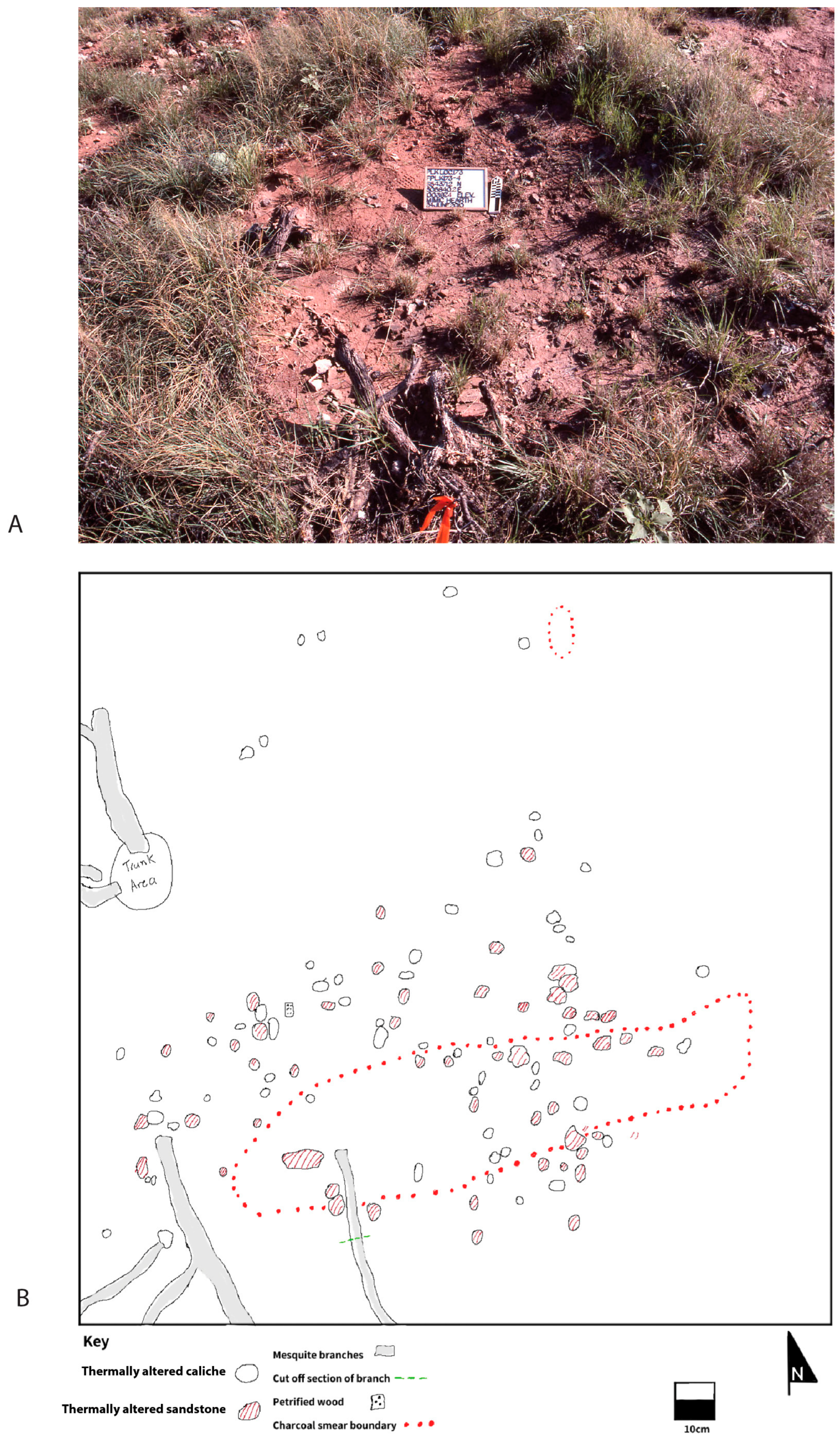
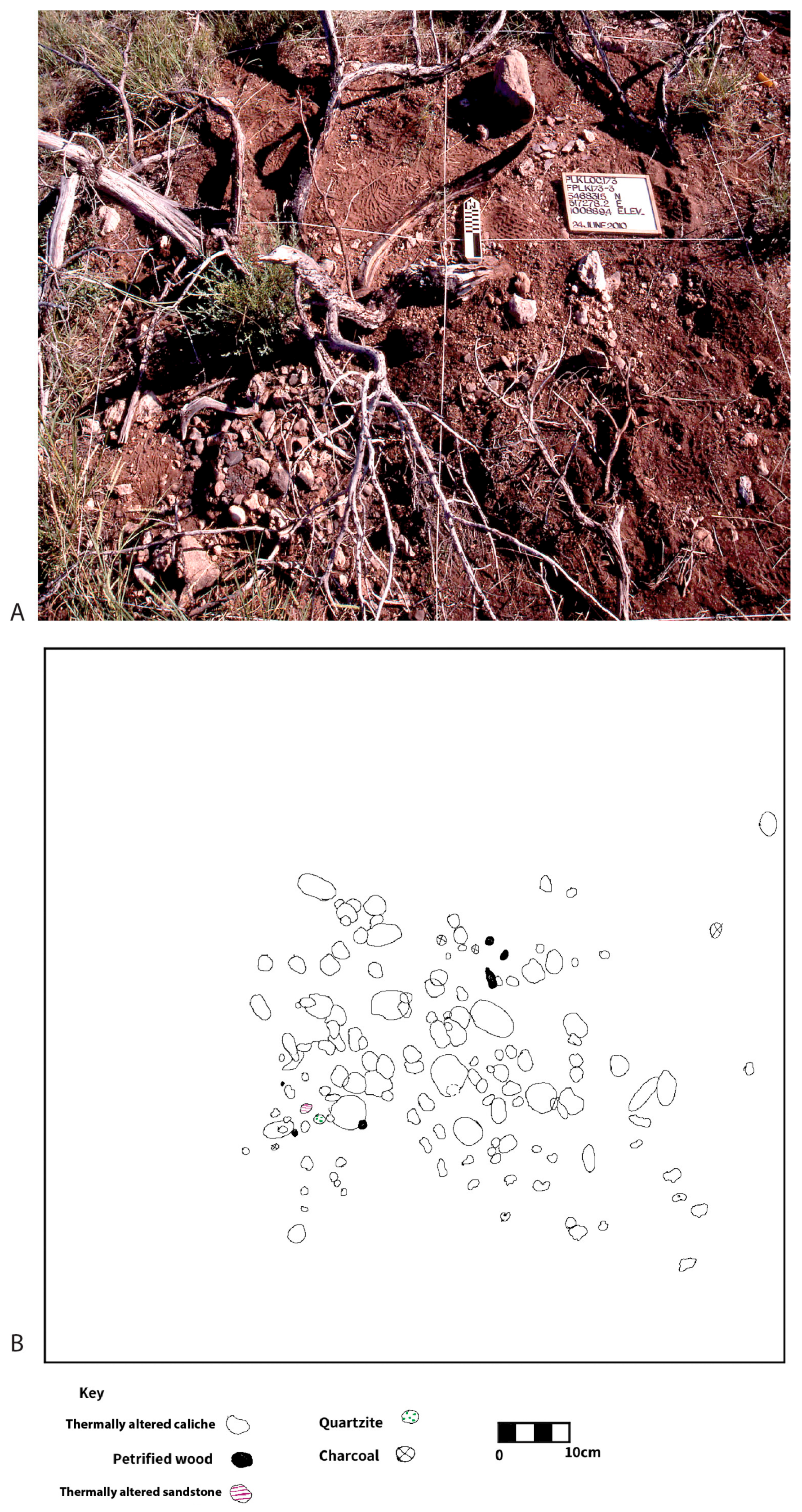
Fourteen mimic hearths were mapped using a Trimble R8 GPS base station with sub-centimeter accuracy (
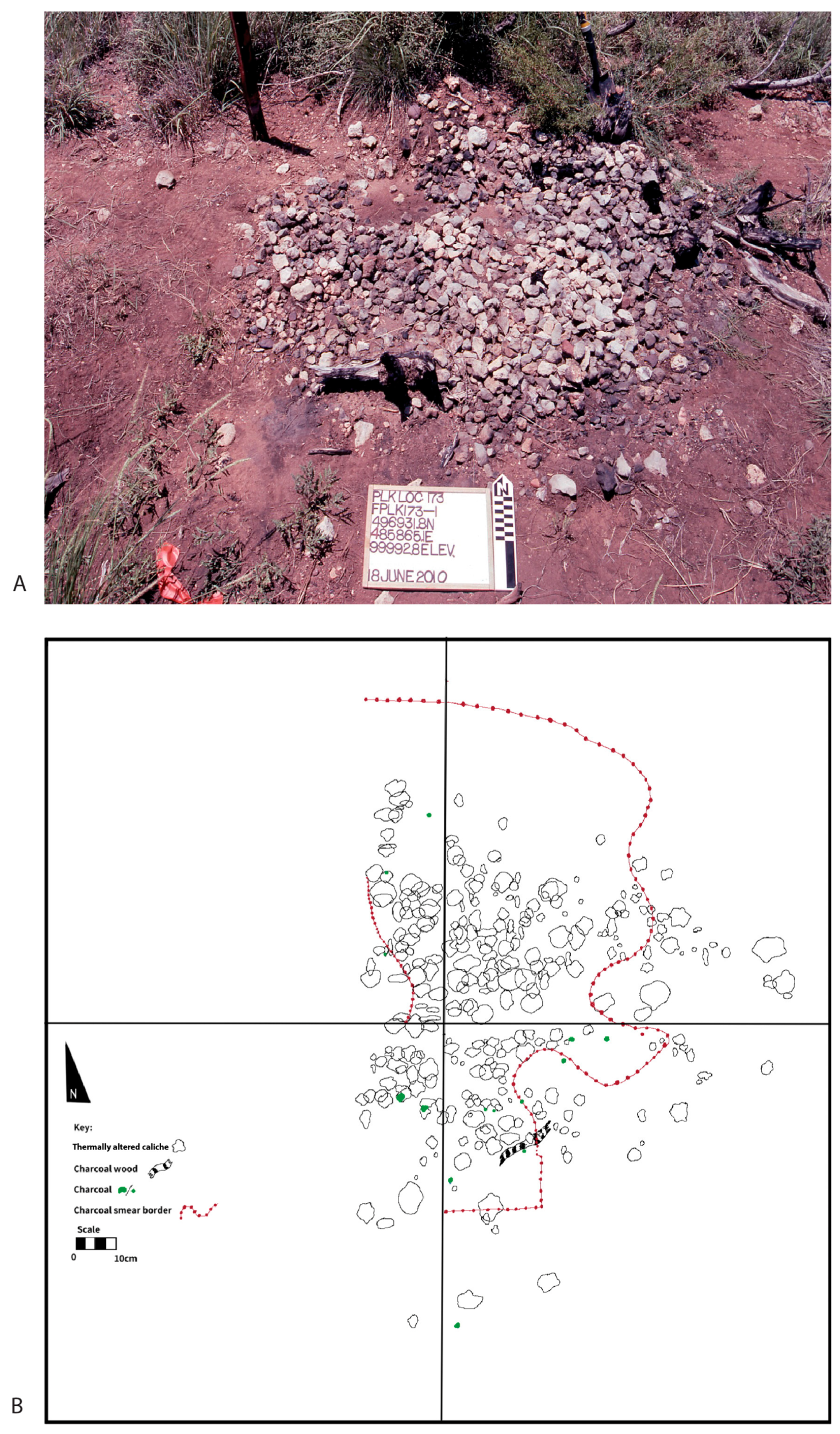
Figure 1), with three undergoing a more detailed analysis. These three were selected for their representativeness and accessibility. Two of the features (FPLK173-3 and FPLK173-4; F = feature; PLK = section of historic ranch; 173-locality number; -1 = specific feature) had their surface objects mapped and collected. For feature FPLK173-1 the eastern half was excavated in 2.5 cm sublevels to document subsurface alteration from the fire. All objects were mapped in situ using hand-held tapes, and elevations were recorded using a line level (Figure 3). A Sharpie was used to mark the top of each thermally altered rock for later analysis differentiation.
Attributes recorded for each collected rock (e.g., [8]) included a top and bottom Munsell color for each rock, whether the rock was fractured from thermal activity, its weight, and maximum length. The Munsell color system was used to assess visually the differences in darkness values between the upper and lower parts of the rock. The top surface was recorded first. The bottom surface then was compared to it to determine any relative change in darkness based on Munsell color values.
In the Munsell system, the value or the degree of darkness varied from 0 (black) to 10 (white) and can be used in quantitative analysis [62]. The rock was classified as even in color if the darkness value was the same on the top and bottom. A difference of 0.5 to 1.5 value was classified as a slight difference, a difference of 2.0 was classified as different, and a difference of 2.5 or greater was classified as greatly different. The maximum length was recorded for each piece of charcoal from FPLK173-1. The thermally altered rocks were collected and analyzed at the field camp, and returned to their original locations after their analysis.

4. Results

The majority of the mimic hearths comprised burned caliche nodules clustered together in an area measuring between 1 and 2 m (Figure 4; Table 1). The burnt rock was the result of the natural fire burning juniper shrubs. Two clusters of burnt rock (FPLK173-4 and FPLK173-5), however, were connected to the burning of mesquite shrubs during the natural wildfire. Some transformation of the caliche nodules chemistry took place in the sense that color change and fire cracking occurred.

4.1. FPLK173-4

One piece of charcoal (15.2 cm max length) and 116 rocks were mapped and analyzed from the surface of FPLK173-4 (Figure 5). Most of the rocks were either caliche nodules (50%, n = 59) or sandstone (47%, n = 55) (Table 2). These rocks typically were less than 50 mm in max length and under 60 g in weight (Table 2). Most of the rocks did not have thermal fractures (Table 3); however, both pieces of petrified wood were fractured (Table 3). Most of the rocks were discolored across their surfaces (Table 4). Additionally, 37 (31.9%) of the rocks had a darker Munsell value on the top surface, typical of wildfires (Table 5). However, 69 of the rocks (59.48%) had a similar darkness on both top and bottom surfaces that is commonly associated with human-made hearths (Table 5).

4.2. FPLK173-3

A total of 19 pieces of charcoal and 399 rocks were mapped and collected from FPLK173-3 (Figure 6). The rocks comprised 85% caliche nodules, with the rest consisting of Ogallala basal gravels and Dockum Group sandstone (Table 6). The rocks typically were less than 45 cm in max length and weighed under 50 g (Table 6). Most caliche and sandstone were not thermally fractured; however, most pieces of Potter Member quartzarenite and petrified wood were fractured (Table 7). The charcoal pieces were relatively large, with an average length of 32.19 cm (SD = 57.91). One partially burned branch was also associated with the mimic hearth and had a length of 230 cm.
Most of the rocks (75%) exhibited evidence of color alteration between 75–100% of the surface (Table 8). Almost half of the rocks (n = 193; 48.37%) had a darker color on their tops in comparison to the underneath surface (Table 9). More common to human-made fires, 42.11% had similar darkness value between the top and bottom surfaces. A small percentage of rocks (n = 38; 9.5%) were darker on their bottom than their top surface (Table 9).

4.3. FPLK173-1

A total of 78 pieces of charcoal and 1625 pieces of thermally modified rock were mapped and collected across the eastern half of FPLK173-1 (Figure 7 and Figure 8). Most of FPLK173-1 comprised caliche nodules (n = 1441; 84%; Table 10). The rest of the thermally altered rocks comprised basal Ogallala gravels and sandstone from the Triassic-age Dockum Group (Table 10). The rocks had an average size under 45 cm with an average weight under 45 g (Table 10).
Large pieces of charcoal and partially charred wood had an average measurement of 18.18 cm (SD = 12.54) in length. Most of the rock clasts were not thermally fractured (Table 11); however, petrified wood, Potter Member quartzarenite, and purple quartzite were fractured more frequently. Most (n = 1203; 73.89%) of the rocks showed evidence of color alteration over 75–100% of their surface (Table 12). Most of the rocks (n = 945; 58.15%) had a darker Munsell color value on their top surfaces, suggesting that natural fires tend to alter the top surfaces of rocks more so than the bottom halves (Table 13). Nevertheless, 22.92% of the rocks had an even Munsell color value that is typical for hearths (Table 13). The excavation of the eastern half of the thermal feature revealed that the charcoal and ash layer extended ~2–5 cm in depth, with no discernable hearth basin delineated (Figure 8).

5. Discussion

A survey conducted at PLK Locality 173 identified 14 thermal features created by a 2008 wildfire. On landscape ridges with a combination of gravel deposits and burned shrubs, the surface mimicked the appearance of anthropogenic hearths. Rocks from the surface of three of the features were analyzed using hearthstone methodology [8] to determine if wildfires could modify the surrounding rocks to create a feature that could be mistaken for a cultural hearth. The eastern half of one of these three (FPLK173-1) was also excavated to document the cross-section of a naturally produced thermal feature.
Over 70% of the rocks in each of the thermal features were discolored across their entire surface area (Table 4, Table 8, and Table 12). This high frequency of discoloration was due to nearby shrubs that sustained burning for a longer period than just grass resulting in a more complete discoloration of rocks. Also mimicking anthropogenic fires were rocks that were darkened evenly on both their top and bottom surfaces. Between 20 and 60 percent of rocks in each of the hearths (Table 5, Table 9, and Table 13) were darkened evenly on both their top and bottom surfaces. However, 30–60 percent of rocks in each of the mimic hearths were darkened more on their top surfaces in comparison to their bottom—typical for regional fires [26,58,60] and not indicative of an anthropogenic hearth.
Most rocks in the studied mimic hearths are not thermally fractured, aligning with findings on caliche nodules [8], the dominant rock in these features. Rocks with a higher silica content (e.g., chert, petrified wood, Potter Member quartzarenite, purple quartzite) tend to fracture more when rapidly heated [28,63,64]. Fracture frequency is not a reliable criterion to differentiate between natural and anthropogenic fires. Caliche rarely fractures, while high-silica rocks frequently do so, typical of anthropogenic hearths.
Excavation of the eastern half of FPLK173-1 revealed a thin layer of charcoal, ash, and large pieces of partially burned wood, indicating incomplete combustion. Bellomo [3] noted that burning trees act as insulators, preventing the high temperatures seen in anthropogenic fires, thus leaving larger charcoal pieces. A similar effect occurs when shrubs and their associated deadfall burn, producing low-temperature, smoldering fires that inhibit complete combustion. Additionally, the thin layer of charcoal and ash, along with the absence of an excavated basin for the hearth, suggests it is not an anthropogenic hearth but a natural mimic feature.
On the surface, these mimic hearths closely resemble those of anthropogenic hearths, largely due to the high frequency of discoloration and thermal fracturing of rocks with higher silica content. A detailed investigation, however, reveals evidence for distinguishing between anthropogenic and naturally produced thermal features. Although 30–60% of the hearthstones exhibited similar darkness values on both their top and bottom surfaces, a significant proportion (20–60%) displayed darker top surfaces compared to their bottom surfaces. This variation in the distribution of darkness values is more indicative of a natural fire than an anthropogenic hearth that typically results in more uniform coloration across both surfaces of the rocks [8]. These natural thermal features also lack a basin characteristic of anthropogenic hearths, and the incomplete combustion of charcoal further differentiates them from cultural hearths.
Another notable distinction between the mimic hearths and cultural hearths lies in the size distribution of hearthstones. In cultural hearths, the range of hearthstone sizes tends to be broader, with many individual stones exceeding 1000 g in weight [8,28]. In contrast, the mimic hearths predominantly comprise significantly smaller stones, most weighing under 100 g. One possible explanation for this disparity is the potential for hearthstones to be reused across multiple episodes of fire use [8,64]. Repeated heating and manipulation may cause hearthstones to fracture and diminish in size over time, resulting in an assemblage of uniformly smaller stones. Consequently, the mimic hearths more closely resemble the material signature of a reused cultural hearth rather than that of a single-use or initial-use thermal feature.

6. Conclusions

Wildfires can create thermal features that resemble cultural hearths, particularly when a shrub burns alongside natural rocks commonly found in regional hearths. The intense heat from such natural fires is often sufficient to alter the surfaces of rocks and cause fractures in rocks with a high silica content due to rapid temperature changes. Over time, weathering can erase the traces of burned shrubs and the wildfire, making it challenging to determine whether a thermal feature on the surface resulted from human activity or natural fire. This research indicates that comparing the Munsell darkness values of the top and bottom surfaces of thermally altered rocks can reveal wildfire evidence, with darker tops being a key indicator. The presence of a thin layer of charcoal and ash, along with larger charcoal pieces, suggests wildfire rather than human origin. While the combustion of shrubs and associated deadfall can generate enough heat to thermally alter and fracture rocks, the smoldering behavior of this material moderates the fire’s intensity, frequently preventing complete combustion of the wood. Moreover, fractured rocks alone cannot reliably differentiate between cultural and natural thermal features, as shrub fires can fracture high-silica rocks without fully burning them, complicating the identification process.
A key direction for future research in distinguishing wildfire-generated features from anthropogenic thermal features is the implementation of longitudinal studies to evaluate the effects of weathering and sedimentation over time. These taphonomic processes likely alter the appearance of wildfire-produced features in ways that increasingly resemble cultural hearths. Particular attention should be given to the occurrence of thermally curved spalls of knappable stone [23,28], which may serve as important diagnostic indicators of anthropogenic fire use. Additionally, further controlled experimentation is needed to assess the influence of basin depth, basin size, and other variables on hearthstone formation. Experimental studies should also investigate whether variations in fire maintenance practices during cultural activities affect the size and preservation of charcoal fragments, as this may aid in differentiating cultural from natural thermal features.

Author Contributions

Conceptualization, S.H., D.C. and E.J.; methodology, S.H.; software, S.H.; validation, S.H., formal analysis, S.H. and G.F.-C.; investigation, S.H., D.C. and E.J.; resources, E.J.; data curation, E.J.; writing—original draft preparation, S.H.; writing—review and editing, S.H., E.J. and G.F.-C.; visualization, S.H. and G.F.-C.; supervision, S.H., D.C. and E.J.; project administration, E.J. All authors have read and agreed to the published version of the manuscript.

Funding

This research received no external funding.

Data Availability Statement

All data are housed at the Museum of Texas Tech University and available upon request.

Acknowledgments

The authors thank the landowners for graciously allowing us access to the ranch. The manuscript represents part of the ongoing Lubbock Lake Landmark regional research into Late Quaternary landscape development and climatic and ecological change on the Southern Plains.

Conflicts of Interest

The authors declare no conflicts of interest.

References

  1. Backhouse, P.N.; Johnson, E. Hearth Life: An Experimental Examination of Site-Formation Processes Acting on Upland Hunter-Gatherer Camp Site Assemblages on the Southern High Plains. Plains Anthropol. 2007, 52, 175–194. [Google Scholar] [CrossRef]
  2. Black, S.L.; Thorns, A.V. Hunter-Gatherer Earth Ovens in the Archaeological Record: Fundamental Concepts. Am. Antiq. 2017, 79, 204–226. [Google Scholar] [CrossRef]
  3. Bellomo, R.V. A Methodological Approach for Identifying Archaeological Evidence of Fire Resulting from Human Activities. J. Archaeol. Sci. 1993, 20, 525–553. [Google Scholar] [CrossRef]
  4. Brown, K.S.; Marean, C.W.; Herries, A.I.; Jacobs, Z.; Tribolo, C.; Braun, D.; Roberts, D.L.; Meyer, M.C.; Bernatchez, J. Fire as an Engineering Tool of Early Modern Humans. Science 2009, 325, 859–862. [Google Scholar] [CrossRef]
  5. Goldberg, P.; Miller, C.E.; Mentzer, S.M. Recognizing Fire in the Paleolithic Archaeological Record. Curr. Anthropol. 2017, 58, S175–S190. [Google Scholar] [CrossRef]
  6. Holdaway, S.J.; Davies, B.; Fanning, P.C. Aboriginal Use of Fire in a Landscape Context: Investigating Presence and Absence of Heat-Retainer Hearths in Western New South Wales, Australia. Curr. Anthropol. 2017, 58, S230–S242. [Google Scholar] [CrossRef]
  7. Thoms, A.V. The Fire Stones Carry: Ethnographic Records And Archaeological Expectations For Hot-Rock Cookery In Western North America. J. Anthropol. Archaeol. 2008, 27, 443–460. [Google Scholar] [CrossRef]
  8. Backhouse, P.N.; Johnson, E.; Brackenreed-Johnston, A.; Buchanan, B. Experimental Hearths and the Thermal Alteration of Caliche on the Southern High Plains. Geoarchaeology 2005, 20, 695–716. [Google Scholar] [CrossRef]
  9. Thoms, A.V. Rocks of Ages: Propagation of Hot-Rock Cookery in Western North America. J. Archaeol. Sci. 2009, 36, 573–591. [Google Scholar] [CrossRef]
  10. Graesch, A.P.; DiMare, T.; Schachner, G.; Schaepe, D.M.; Dallen, J. Thermally Modified Rock: The Experimental Study of “Fire-Cracked” Byproducts of Hot Rock Cooking. North Am. Archaeol. 2014, 35, 167–200. [Google Scholar] [CrossRef]
  11. Neubauer, F. Use-Alteration Analysis of Fire-Cracked Rocks. Am. Antiq. 2018, 83, 681–700. [Google Scholar] [CrossRef]
  12. Aldeias, V. Experimental Approaches to Archaeological Fire Features and Their Behavioral Relevance. Curr. Anthropol. 2017, 58, S191–S205. [Google Scholar] [CrossRef]
  13. Alperson-Afil, N. Spatial Analysis of Fire. Curr. Anthropol. 2017, 58, S258–S266. [Google Scholar] [CrossRef]
  14. Rudner, E.; Sumegi, P. Charcoal as Remain of Natural and Human-set Fires of Palaeolithic Times-case Study From Hungary. BAR Int. Ser. 2002, 1089, 11–18. [Google Scholar]
  15. Seabloom, R.W.; Sayler, R.D.; Ahler, S.A. Effects of Prairie Fire on Archaeological Artifacts. Natl. Park Serv. Park Sci. 1991, 11, 1–2. [Google Scholar]
  16. Snitker, G.; Roos, C.I.; Sullivan, A.P., III; Maezumi, S.Y.; Bird, D.W.; Coughlan, M.R.; Loehman, R.A. A Collaborative Agenda for Archaeology and Fire Science. Nat. Ecol. Evol. 2022, 7, 835–839. [Google Scholar] [CrossRef]
  17. Snitker, G. Identifying Natural and Anthropogenic Drivers of Prehistoric Fire Regimes through Simulated Charcoal Records. J. Archaeol. Sci. 2018, 95, 1–15. [Google Scholar] [CrossRef]
  18. Hanson, M.; Cain, C.R. Examining Histology to Identify Burned Bone. J. Archaeol. Sci. 2007, 34, 1902–1913. [Google Scholar] [CrossRef]
  19. Buenger, B.A. The Impact of Wildland and Prescribed Fire on Archaeological Resources; University of Kansas: Lawrence, KS, USA, 2003. [Google Scholar]
  20. Shipman, P.; Foster, G.; Schoeninger, M. Burnt Bones and Teeth: An Experimental Study of Color, Morphology, Crystal Structure and Shrinkage. J. Archaeol. Sci. 1984, 11, 307–325. [Google Scholar] [CrossRef]
  21. Stahlschmidt, M.C.; Mentzer, S.M.; Heinrich, S.; Cooper, A.; Grote, M.N.; McNeill, P.J.; Wilder, J.C.B.; Steele, T.E. Impact of a Recent Wildfire on Tortoises at Cape Point, South Africa, and Implications for the Interpretation of Heated Bones in the Archaeological Record. Archaeol. Anthropol. Sci. 2023, 15, 126. [Google Scholar] [CrossRef]
  22. Buikstra, J.E.; Swegle, M. Bone modification due to burning: Experimental evidence. In Bone Modification; Bonnichsen, R., Sorg, M.H., Eds.; Center for the Study of the First Americans, Institute of Quaternary Studies, University of Maine: Orono, ME, USA, 1989; pp. 247–258. [Google Scholar]
  23. Cutts, R.B.; Hlubik, S.; Campbell, R.; Muschinski, J.; Akuku, P.; Braun, D.R.; Patterson, D.B.; O’Brien, J.J.; Garrison, E.; Harris, J.W.K. Thermal Curved-Fragments: A Method for Identifying Anthropogenic Fire in the Archaeological Record. J. Archaeol. Sci. 2019, 106, 10–22. [Google Scholar] [CrossRef]
  24. Braadbaart, F.; Poole, I.; Huisman, H.D.J.; van Os, B. Fuel, Fire and Heat: An Experimental Approach to Highlight the Potential of Studying Ash and Char Remains from Archaeological Contexts. J. Archaeol. Sci. 2012, 39, 836–847. [Google Scholar] [CrossRef]
  25. Aldeias, V.; Dibble, H.L.; Sandgathe, D.; Goldberg, P.; McPherron, S.J.P. How Heat Alters Underlying Deposits and Implications for Archaeological Fire Features: A Controlled Experiment. J. Archaeol. Sci. 2016, 67, 64–79. [Google Scholar] [CrossRef]
  26. Werts, S.P.; Jahren, A.H. Estimation of Temperatures Beneath Archaeological Campfires Using Carbon Stable Isotope Composition of Soil Organic Matter. J. Archaeol. Sci. 2007, 34, 850–857. [Google Scholar] [CrossRef]
  27. March, R.J.; Lucquin, A.; Joly, D.; Ferreri, J.C.; Muhieddine, M. Processes of Formation and Alteration of Archaeological Fire Structures: Complexity Viewed in the Light of Experimental Approaches. J. Archaeol. Method Theory 2012, 21, 1–45. [Google Scholar] [CrossRef]
  28. Backhouse, P.N.; Johnson, E. Where were the Hearths: An Experimental Investigation of the Archaeological Signature of Prehistoric Fire Technology in the Alluvial Gravels of the Southern Plains. J. Archaeol. Sci. 2007, 34, 1367–1378. [Google Scholar] [CrossRef]
  29. Backhouse, P.N. Exploring Prehistoric Lifeways in the Shadow of the Llano Estacado: Recent Research in the Upper Brazos. In Texas and Points West; Wiseman, R.N., O’Laughlin, T.C., Snow, C.T., Eds.; The Archaeological Society of New Mexico: Albuquerque, NM, USA, 2007; Volume 33, pp. 19–38. [Google Scholar]
  30. Lintz, C. Experimental Thermal Discoloration and Heat Conductivity Studies of Caliche from Eastern New Mexico. Geoarchaeology 1989, 4, 319–346. [Google Scholar] [CrossRef]
  31. Custer, J.F. Experimental Analysis of Fire-cracked Rocks from Varied Use Contexts. North Am. Archaeol. 2017, 38, 237–291. [Google Scholar] [CrossRef]
  32. Johnson, E. Landscapes and Peoples of the Llano Estacado. In Archaeological Landscapes on the High Plains; Scheiber, L.L., Clark, B.J., Eds.; University Press of Colorado: Boulder, CO, USA, 2008; pp. 115–156. [Google Scholar]
  33. Johnson, E.; Holliday, V.T. Archeology and Late Quaternary Environments of the Southern High Plains. In The Prehistory of Texas; Perttula, T., Ed.; Texas A&M University Press: College Station, TX, USA, 2004; pp. 283–295. [Google Scholar]
  34. Backhouse, P.N. Hunter-Gatherer Fire Technology and the Archaeological Record of the Southern High Plains, USA. BAR Int. Ser. 2010, 2114, 1–189. [Google Scholar]
  35. Fenneman, N.M. Physiography of Western United States; McGraw-Hill Book Company: New York, NY, USA, 1931. [Google Scholar]
  36. Sabin, T.J.; Holliday, V.T. Playas and Lunettes on the Southern High Plains: Morphometric and Spatial Relationships. Ann. Assoc. Am. Geogr. 1995, 85, 286–305. [Google Scholar] [CrossRef]
  37. Holliday, V.T. The Blackwater Draw Formation (Quaternary): A 1-4-Plus-My Record of Eolian Sedimentation and Soil Formation on the Southern High Plains. Geol. Soc. Am. Bull. 1989, 101, 1598–1607. [Google Scholar] [CrossRef]
  38. Holliday, V.T.; Welty, C.M. Lithic Tool Resources of the Eastern Llano Estacado. Bull. Tex. Archeol. Soc. 1981, 52, 201–214. [Google Scholar]
  39. Gustavson, T.C.; Baumgardner, R.W., Jr.; Caran, S.C.; Holliday, V.T.; Mehnert, H.H.; O’’Neill, J.M. Quaternary geology of the Southern Great Plains and an Adjacent Segment of the Rolling Plains. In Quaternary Nonglacial Geology: Conterminous U.S. Centennial Volume K-2; Morrison, R.B., Ed.; Geological Society of America: Boulder, CO, USA, 1991; pp. 477–501. [Google Scholar]
  40. Holliday, V.T. The Central Lowlands and Great Plains. In The Physical Geography of North America; Orme, A.R., Ed.; Oxford Press: Oxford, UK, 2002. [Google Scholar]
  41. Ferring, C.R. Archaeological Geology of the Southern Plains. In Archaeological Geology of North America; Lasca, N.P., Donahue, J., Eds.; Geological Society of America: Boulder, CO, USA, 1990; pp. 253–266. [Google Scholar]
  42. Gustavson, T.C.; Simpkins, W.W. Geomorphic Processes and Rates of Retreat Affecting the Caprock Escarpment, Texas Panhandle; The University of Texas at Austin: Austin, TX, USA, 1989. [Google Scholar]
  43. Lehman, T.; Chatterjee, S. Depositional Setting and Vertebrate Biostratigraphy of the Triassic Dockum Group of Texas. J. Earth Syst. Sci. 2005, 114, 325–351. [Google Scholar] [CrossRef]
  44. Frendlund, G.; Holliday, V.T.; Johnson, E. Vegetation Change on the Southern High Plains during the Pleistocene-Holocene Transition. In Proceedings of the Paper Presented at the XVI INQUA Congress, Reno, NV, USA, 23–30 July 2003. [Google Scholar]
  45. Hall, S.A.; Valastro, S., Jr. Grassland Vegetation in the Southern Great Plains during the Last Glacial Maximum. Quat. Res. 1995, 44, 237–245. [Google Scholar] [CrossRef]
  46. Holliday, V.T. Stratigraphy and Paleoenvironments of Late Quaternary Valley Fills on the Southern High Plains (Memoir/Geological Society of America, 186); Geological Society of America: Boulder, CO, USA, 1995; Volume 186, p. 142. [Google Scholar]
  47. Johnson, E. Late Pleistocene and Early Holocene Vertebrates and Paleoenvironments on the Southern High Plains, U.S.A. Géographie Phys. Et Quat. 1986, 40, 249. [Google Scholar] [CrossRef]
  48. Johnson, E. Grassland Ecosystems of the Llano Estacado. In Shrubland Dynamics: Fire & Water; Sosebee, R.E., Wester, D.B., Britton, C.M., McArtur, E.D., Kitchens, S., Eds.; U.S. Department of Agriculture: Fort Collins, CO, USA, 2007; pp. 11–23. [Google Scholar]
  49. Gregg, J.A. Commerce of the Prairies; University of Oklahoma Press: Norman, OK, USA, 1954. [Google Scholar]
  50. Holden, W.C. The Land. In A History of Lubbock; Graves, L.L., Ed.; West Texas Museum Association: Lubbock, TX, USA, 1962. [Google Scholar]
  51. Marcy, R. Reports of Explorations and Surveys to Ascertain the Most Practicable and Economical Route for a Railroad from the Mississipi River to the Pacific Ocean; United States War Department, Government Printing: Washington, DC, USA, 1854; Volume 2. [Google Scholar]
  52. Pope, J. Exploration of a Route for the Pacific Railroad, Near the Thirty-Second Parallel, from the Red River to the Rio Grande. 1st Session, 33rd Congress. House Executive Document 129; Government Printing Office: Washington, DC, USA, 1854.
  53. Pope, J. Report of the Explorations Near the Thirty-Second Parallel of North Latitude from the Red River to the Rio Grande. In Vol. 2: Report of the Exploration and Survey from the Mississippi River to the Pacific Ocean. 2nd session, 33rd Congress. Senate Executive Document 78; Government Printing Office: Washington, DC, USA, 1855. [Google Scholar]
  54. Harrington, H.D. Western Edible Wild Plants; University of New Mexico Press: Albuquerque, NM, USA, 1972. [Google Scholar]
  55. Neithammer, C. American Indian Food and Lore; Macmillian: New York, NY, USA, 1974. [Google Scholar]
  56. Thompson, J.L. Modern, Historic, and Fossil Flora. In Lubbock Lake: Late Quaternary Studies on the Southern High Plains; Johnson, E., Ed.; Texas A&M University Press: College Station, TX, USA, 1987; pp. 26–35. [Google Scholar]
  57. Briggs, J.M.; Knapp, A.K.; Blair, J.M.; Heisler, J.L.; Hoch, G.A.; Lett, M.S.; McCarron, J.K. An Ecosystem in Transition: Causes and Consequences of the Conversion of Mesic Grassland to Shrubland. BioScience 2005, 55, 243–254. [Google Scholar] [CrossRef]
  58. Ford, P.L. Response of Buffalo Grass (Buckloë dactyloides) and Blue Grama (Bouteloua gracilis) to Fire. Great Plains Res. 1999, 9, 261–276. [Google Scholar]
  59. Ladkin, N. Burned Caliche from the 1988 Excavations; Museum of Texas Tech University: Lubbock, TX, USA, 1993. [Google Scholar]
  60. Thoms, A.V.; Proctor, D. Archaeological Reconnaissance Survey of Portions of the Flood Control Improvement Area. Plainview, TX; Department of Anthropology, Texas Tech University: Lubbock, TX, USA, 1977. [Google Scholar]
  61. Hurst, S.; Cunningham, D.; Johnson, E. Experiments in Late Archaic Methods of Heat-treating Ogallala Formation Quartzarenite Clasts along the Southern High Plains Eastern Escarpment of Texas. J. Archaeol. Sci. Rep. 2015, 3, 207–215. [Google Scholar] [CrossRef]
  62. Ruck, L.; Brown, C.T. Quantitative Analysis of Munsell Color Data from Archeological Ceramics. J. Archaeol. Sci. Rep. 2015, 3, 549–557. [Google Scholar] [CrossRef]
  63. Schmidt, P. What Causes Failure (overheating) During Lithic Heat Treatment? Archaeol. Anthropol. Sci. 2014, 6, 107–112. [Google Scholar] [CrossRef]
  64. Neubauer, F. Fire-Cracked Rock Analysis: A Guide to Function, Cooking and Interpretation; Springer: Cham, Switzerland, 2024. [Google Scholar]
Figure 1. Location of natural thermal features located on high points on the landscape at PLK Locality 173, western Rolling Plains near Post, Texas. (A) Regional map of the Post research area in relationship to the Southern High Plains in northwestern, Texas. (B) Close-up of PLK Locality 173 in relationship to the Post research area. (C) Location of thermal features FPLK#s at PLK Locality 173.
Land 14 01364 g001
Figure 2. Burned juniper located at the center of the mimic thermal feature FPLK173-14, resulting from the natural wildfire (17–18 April 2008), western Rolling Plains near Post, Texas.
Land 14 01364 g002
Figure 3. The field crew mapping a natural thermal feature (FPLK173-1) created from a 2008 wildfire at PLK Locality 173 on a historic ranch near Post, Texas (USA).
Land 14 01364 g003
Figure 4. Mimic hearth features at PLK Locality 173 on a historic ranch near Post, Texas (USA).
Land 14 01364 g004
Figure 5. (A) Thermally altered rock and burned mesquite at FPLK 173-4. (B) Plan view map of distribution of thermally altered rock at FPLK 173-4.
Land 14 01364 g005
Figure 6. (A) Thermally altered rock and burned juniper at FPLK 173-3. (B) Plan view map of distribution of thermally altered rock at FPLK 173-3.
Land 14 01364 g006
Figure 7. Profile of eastern half of FPLK173-1 after excavation on a historic ranch near Post, Texas (USA).
Land 14 01364 g007
Figure 8. (A) Thermally altered rock and burned juniper at FPLK 173-1. (B) Plan view map of distribution of thermally altered rock at FPLK 173-1.
Land 14 01364 g008
Table 1. Characteristics of mimic hearth features and type of shrub that burned during a 2008 wildfire on a historic ranch near Post, Texas (USA).
Feature NumberPredominate Rock Type PresentAssociated ShrubApproximate Size
FPLK173-1CalicheJuniper1 m2
FPLK173-2SandstoneJuniper1 m2
FPLK173-3CalicheJuniper1 m2
FPLK173-4Caliche and SandstoneMesquite2 m2
FPLK173-5CalicheMesquite2 m2
FPLK173-6Potter member quartzareniteJuniper1 m2
FPLK173-7CalicheJuniper2 m2
FPLK173-8CalicheJuniper1 m2
FPLK173-9Caliche and Potter member quartzareniteJuniper1.5 m2
FPLK173-10CalicheJuniper1 m2
FPLK173-11Potter member quartzareniteJuniper10 m2
FPLK173-12CalicheJuniper3 m2
FPLK173-13CalicheJuniper3 m2
FPLK173-14Caliche and SandstoneJuniper2 m2
Table 2. Composition, max length, and weight of rocks for natural thermal feature FPLK173-4 from a 2008 wildfire on a historic ranch near Post, Texas (USA).
Rock TypeTotal No.Max Length (mm)Weight (g)
MeanStandard DeviationMeanStandard Deviation
Caliche5948.0317.1758.6630.58
Petrified Wood249.9214.3140.5619.89
Sandstone5548.7514.5544.28160.26
Total116
Table 3. Frequency of fractured thermally altered rock for natural thermal feature FPLK173-4 from a 2008 wildfire on a historic ranch near Post, Texas (USA).
Rock TypeFractured (Total Number (%))Not-Fractured (Total Number (%))
Caliche9 (26.47)50 (60.98)
Petrified Wood2 (100.00)0 (0.00)
Sandstone32 (39.02)23 (67.65)
Total43 (37.06)73 (62.94)
Table 4. Percent of rock’s surface with thermal alteration for natural thermal feature FPLK173-4 from a 2008 wildfire on a historic ranch near Post, Texas (USA).
Percent Surface BurnedCountPercent
032.59
1–2554.31
25–5065.17
50–75119.48
75–1009178.45
Total116100.00
Table 5. Degree of thermal darkening difference (Munsell values) between the top and bottom rock surface for natural thermal feature FPLK173-4 from a 2008 wildfire on a historic ranch near Post, Texas (USA).
Munsell Difference in Degree of Darkness Value—Top/Bottom Surface CountPercent
Greatly More Dark on TopLand 14 01364 i00143.45
More Dark on TopLand 14 01364 i0021311.21
Sightly More Dark on TopLand 14 01364 i0032017.24
EvenLand 14 01364 i0046959.48
Slightly More Dark on BottomLand 14 01364 i00565.17
More Dark on BottomLand 14 01364 i00643.45
Total 116100.00
Table 6. Composition, max length, and weight of rocks for natural thermal feature FPLK173-3 from a 2008 wildfire on a historic ranch near Post, Texas (USA).
Rock TypeTotal No.Max Length (mm)Weight (g)
MeanStandard DeviationMeanStandard Deviation
Caliche34039.9217.3933.8843.61
Petrified Wood3534.5812.9520.9321.97
Potter Member Quartzarenite943.4511.6815.6413.26
Purple Quartzite141.83-48.4-
Quartzite632.3210.4120.7116.23
Sandstone838.8513.2016.789.44
Total399
Table 7. Frequency of fractured thermally altered rock for natural thermal feature FPLK173-3 from a 2008 wildfire on a historic ranch near Post, Texas (USA).
Rock TypeFractured (Total Number (%))Not-Fractured (Total Number (%))
Caliche50 (14.75)290 (85.25)
Petrified Wood23 (65.71)12 (34.39)
Sandstone1 (12.50)7 (87.50)
Potter member quartzarenite12 (75.00)4 (25.00)
Total86 (21.55)313 (78.44)
Table 8. Percent of rock’s surface with thermal alteration for natural thermal feature FPLK173-3 from a 2008 wildfire on a historic ranch near Post, Texas (USA).
Percent Surface BurnedCountPercent
0164.01
1–25399.77
25–50276.77
50–75194.76
75–10029874.69
Total399
Table 9. Degree of thermal darkening difference (Munsell values) between the top and bottom rock surface for natural thermal feature FPLK173-3 from a 2008 wildfire on a historic ranch near Post, Texas (USA).
Munsell Difference in Degree of Darkness Value—Top/Bottom Surface CountPercent
Greatly More Dark on TopLand 14 01364 i0075313.28
More Dark on TopLand 14 01364 i0086917.29
Slightly More Dark on topLand 14 01364 i0097117.79
EvenLand 14 01364 i01016842.11
Slightly More Dark on bottomLand 14 01364 i011194.76
More Dark on bottomLand 14 01364 i01292.26
Greatly More on bottomLand 14 01364 i013102.51
Total 399100.00
Table 10. Composition, max length, and weight of rocks for natural thermal feature FPLK173-1 from a 2008 wildfire on a historic ranch near Post, Texas (USA).
Total NoMax Length (mm) Weight (g)
Rock Type MeanStandard DeviationMeanStandard Deviation
Caliche144133.1213.4119.1419.14
Chert, Ogallala Gravel726.089.8910.3110.31
Petrified Wood9934.5112.8544.9544.95
Purple Quartzite740.129.5118.1118.11
Potter Member Quartzarenite6227.6212.7715.0915.09
Sandstone837.1611.6617.7217.72
Siltstone 122.732.50
Total1625
Table 11. Frequency of fractured thermally altered rock for natural thermal feature FPLK173-1 from a 2008 wildfire on a historic ranch near Post, Texas (USA).
Rock TypeFractured (Total Number (%))Not-Fractured (Total Number (%))
Caliche271 (18.79)1171 (81.21)
Petrified Wood74 (75.51)24 (24.49)
Purple Quartzite4 (57.14)3 (42.86)
Sandstone1 (12.50)7 (87.50)
Chert2 (28.57)5 (71.43)
Potter member quartzarenite28 (44.44)35 (55.56)
Grand Total380 (23.39)1245 (76.61)
Table 12. Percent of rock’s surface with thermal alteration for natural thermal feature FPLK173-1 from a 2008 wildfire on a historic ranch near Post, Texas (USA).
Percent Surface BurnedCountPercent
0422.58
1–25845.16
25–501066.51
50–7519011.69
75–100120373.89
Total1625100
Table 13. Degree of thermal darkening difference (Munsell values) between the top and bottom rock surface for natural thermal feature FPLK173-1 from a 2008 wildfire on a historic ranch near Post, Texas (USA).
Munsell Difference in Degree of Darkness Value—Top/Bottom Surface CountPercent
Greatly More Dark on TopLand 14 01364 i01432419.95
More Dark on TopLand 14 01364 i01528117.30
Slightly More Dark on topLand 14 01364 i01634020.94
EvenLand 14 01364 i01737322.91
Slightly More Dark on bottomLand 14 01364 i01818911.64
More Dark on bottomLand 14 01364 i019664.06
Greatly More on bottomLand 14 01364 i020523.20
Total 1625100.00
Disclaimer/Publisher’s Note: The statements, opinions and data contained in all publications are solely those of the individual author(s) and contributor(s) and not of MDPI and/or the editor(s). MDPI and/or the editor(s) disclaim responsibility for any injury to people or property resulting from any ideas, methods, instructions or products referred to in the content.

