Article

Proposal of an Urban Geotourism Itinerary in the UNESCO Global Geopark Volcanes de Calatrava, Ciudad Real (Castilla-La Mancha, Spain): “Volcanoes and Petra Bona (Piedrabuena)”

by
Darío Guevara
1,2,
Rafael Becerra-Ramírez
1,3,*,
Javier Dóniz-Páez
2,3 and
Estela Escobar
1,3
1
Geomorfología, Territorio y Paisaje en Regiones Volcánicas Research Group (GEOVOL-UCLM), Departamento de Geografía y Ordenación del Territorio, Facultad de Letras, Universidad de Castilla-La Mancha, 13071 Ciudad Real, Spain
2
Geopatrimonio y Geoturismo en Espacios Volcánicos Research Group (GEOTURVOL), Departamento de Geografía e Historia, Facultad de Humanidades, Universidad de La Laguna, 38200 San Cristóbal de La Laguna, Spain
3
Instituto Volcanológico de Canarias (INVOLCAN), 38400 Puerto de la Cruz, Spain
*
Author to whom correspondence should be addressed.
Land 2025, 14(7), 1363; https://doi.org/10.3390/land14071363 (registering DOI)
Submission received: 22 May 2025 / Revised: 25 June 2025 / Accepted: 26 June 2025 / Published: 28 June 2025

Abstract

The need to promote proximity tourism in natural areas has made the destinations in the interior of the Iberian Peninsula a benchmark in the development of tourism in traditionally rural and depressed areas. In Ciudad Real province, a sustainable territorial management project was developed based on the uniqueness of its volcanic geoheritage, leading to its designation as the UNESCO Global Geopark “Volcanes de Calatrava, Ciudad Real”. Geoparks promote sustainable activities such as geotourism; thus, an urban geotourism itinerary was proposed in Piedrabuena (Ciudad Real, Castilla-La Mancha) in order to make the natural and cultural geoheritage of a part of the geopark known, which is also a part of the Campo de Calatrava Volcanic Region. For this purpose, 12 natural and cultural resources of the geoheritage of the Piedrabuena volcano, on which the urban centre is located, were identified, inventoried, characterized, and valorised as sites of geotouristic interest, and they were connected along a geotourism itinerary. This itinerary has a 4 km route and up to eight interpretive stops, which allows visitors and tourists to enjoy a geotourism experience based on the volcanic landscape of the geopark, laying the foundations for the creation of other similar experiences.

1. Introduction

In recent years, mature tourist destinations, especially those focused on sun and sand tourism, have continued to show signs of exhaustion in Spain [1,2,3,4]. As a result, a new type of dissatisfied tourist has emerged, one that seeks the beauty of inland landscapes and the culture of small towns. This has led to the development of a form of tourism connected to the natural, rural, and urban environment, transforming it into a cultural consumption product and a tourist attraction [5,6]. In this context, the development of a geotourism proposal is justified, and it is based on three fundamental pillars: territorial heritage, the landscape as a cultural asset, and the identity of towns [7]. Furthermore, sustainability parameters that are linked to the Sustainable Development Goals of the 2030 Agenda of the United Nations can be included [8].
The identification of novel tourist destinations and the provision of new products under the volcano brand, designated as “sites of geotouristic interest” (SGIs) and associated with the Campo de Calatrava Volcanic Region (hereinafter, CCVR), serve to improve the understanding and dissemination of geoheritage and geodiversity in Castilla-La Mancha, located in the interior of the Iberian Peninsula. The aim of this paper is to improve the region’s tourism offering by creating a distinctive and cohesive thematic experience (an urban geotourism itinerary) to attract visitors and tourists interested in volcanic landforms and landscapes, which can serve as an example for other urban centres that form part of the geopark’s territory.
The integration of sites of geotouristic interest (SGIs) into the UNESCO Global Geopark framework is essential for promoting their geological and geomorphological heritage at an international scale. As of 2025, Spain has a total of 18 UNESCO Global Geoparks—4 with volcanic geoheritage (Table 1)—covering an area of over 30,000 km2 [9]. These are organized within the Spanish Network of UNESCO Global Geoparks, which is part of both the Global Geoparks Network (GGN) and the European Geoparks Network (EGN). The CCVR is part of the broader context of the UNESCO Global Geopark “Volcanes de Calatrava, Ciudad Real”, which was officially recognized as Spain’s seventeenth UNESCO Global Geopark in March 2024 [10].
The importance of the aesthetic and scenic values of the Earth for tourism purposes has increased in recent years, particularly regarding the development of multi-product tourism [11]. The resulting exploitation of urban and rural topography for tourism represents a recent and innovative tourism modality that is gaining significant relevance alongside the practice of geotourism in natural spaces. This development has the potential to create a more comprehensive and integrated tourist experience, encompassing all the natural and cultural elements present in a territory [12,13].
This is what is commonly referred to as “urban geotourism”, which consists of the practice of interpreting and disseminating geodiversity in urban spaces [14,15,16]. It is a novel form of tourism that has primarily been exploited in volcanic areas due to the presence of volcanic rock in populated areas and the attraction it generates [17,18,19,20,21,22,23].
However, its definition is not fully established due to a lack of precision in the terminology, as well as the ambiguity surrounding the term “urban”. In a broad sense, it refers to the urban geography of the municipality, placing the limits on the urbanized area rather than the rural one, or more specifically, within the urban fabric of the municipality in question.
The identifiable heritage could be of a natural or cultural nature, referring in this case to the use of volcanic material in the construction and ornamentation of buildings or other architectural elements present in urban areas. In this sense, the cultural element alone does not offer sufficient relevance unless it is integrated with other elements, such as the geological material itself or the geoforms, which emerge and are discernible in the buildings and urban fabric. This creates a more complete and attractive tourist experience [24].
From this perspective, it is the very location of the cities themselves that generates original, rugged, and softened topographies, on which the city and its layout have adapted throughout history. In addition, the materials used in the construction of buildings, monuments, streets, and other infrastructure are key elements in understanding the geoheritage of any place and its potential use as an urban geotourism resource, as evidenced by studies applied to UNESCO World Heritage sites [25]. The accessibility of the city, in conjunction with the cultural elements and their geological and geomorphological contextualization, facilitates the development of geotourism itineraries within the city [26]. All this is related to the gradual increase in urban geotourism in recent years, which includes the identification of urban geosites or geomorphosites and other sites of interest in the cities [27].
In Díez-Herrero & Vegas-Salamanca [14,15], three geotourism itineraries are identified that could be developed within the urban geography or the population centre in question. One itinerary could be chronological in theme, following the line of geological history, and another could be geological–geomorphological in theme, which focuses on the places and landscapes that allow for the understanding of the territory in all its variations (geoforms). Finally, an itinerary could be spatial in theme, which is similar to the previous ones but does not focus on a specific place. However, rather than being confined to a specific locale, these latter itineraries capitalise on the points of greatest geological and geomorphological uniqueness or the links between different resources, thereby emphasising the space and the interrelation of the elements.
An urban georoute has been developed in the municipality of Ciudad Real [28], which links the natural and cultural elements of volcanic geoheritage and is included in the guided tours offered by the city’s tourist office. The Ciudad Real georoute aims to discover and introduce the public to the elements that will help them understand the geomorphological essence of the urban area, which is shaped by the presence of three maars and their hydro-magmatic deposits: the result of water–magma interaction. The proposed georoute covers several streets and avenues located in the southern part of Ciudad Real, linking five resources that shape the topography and urban fabric, which are key in constructing the image and geotourism appeal of the city itself.

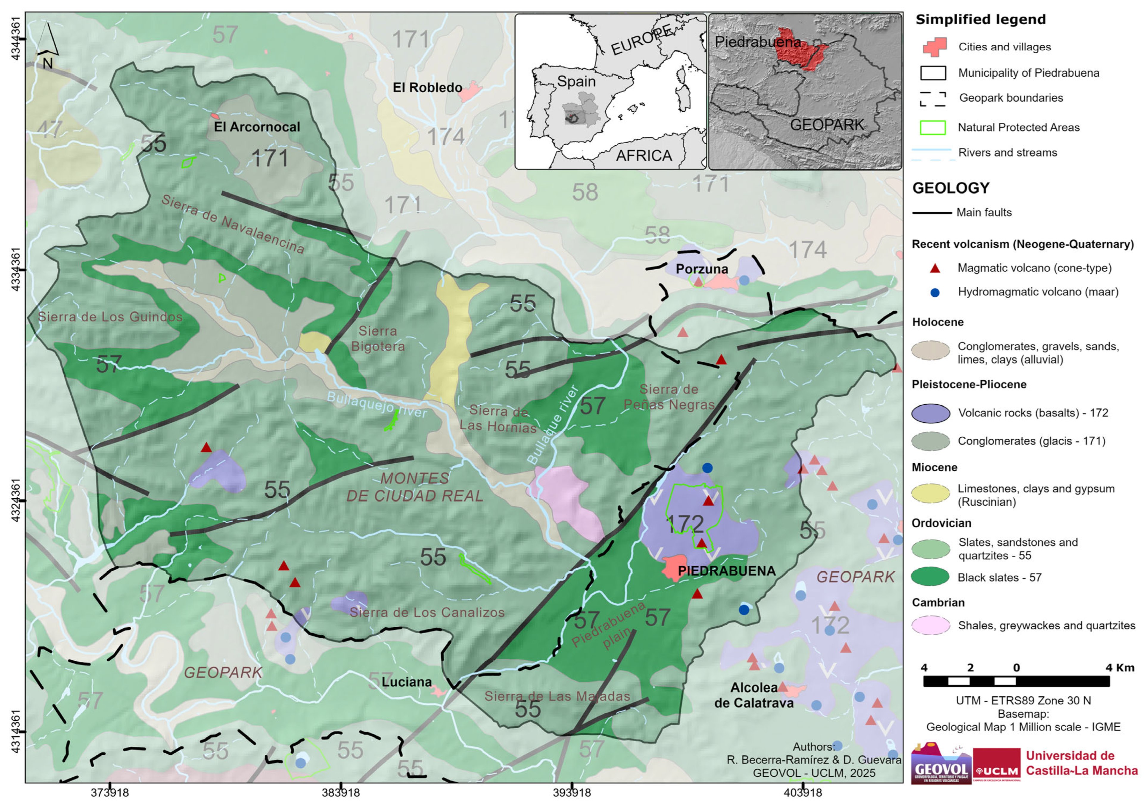
2. Study Area: Petra Bona—Piedrabuena (Castilla-La Mancha, Spain)

The municipality of Piedrabuena is in the northwestern area of the CCVR in the province of Ciudad Real (Castilla-La Mancha, Spain) (Figure 1). The volcanic region borders the regions of Montes de Toledo, Montes de Ciudad Real, Valle de Alcudia, Sierra Madrona, and the La Mancha plain. It is noteworthy that this region encompasses the most extensive volcanic territory in the Iberian Peninsula, with an area of approximately 5200 km2 and the presence of over 360 volcanic structures of magmatic and hydromagmatic origin. These volcanoes, which vary in size, can be found in a variety of morphologies, including scoria cones, spatter cones, lava flows, and maars [29,30].
According to García [31], the municipality is characterised by the presence of several morphostructural units. There are morphostructures corresponding to the oldest Ordovician bedrock (quartzites, sandstones, and slates), and they are folded and fractured, with an Appalachian relief, such as the Solanazo-Valronquillo massif, the Porzuna-Fernán Caballero mountains, and the Piedrabuena-Alcolea mountain range. There is also the Piedrabuena basin, a synclinal depression filled with more recent Pliocene–Pleistocene and Quaternary materials (limestones, marls, and alluvium).
The urban centre is entirely located within the Piedrabuena basin (Figure 2), where there are volcanic morphologies built during eruptions from the lower to middle Pliocene up to the Pleistocene, with periods of calm in between, prior to the incision of the Bullaque river [32], which is the main river artery of the depression. In this territory, effusive and Strombolian eruptions occurred, creating volcanic structures such as spatter cones and scoria cones, as well as hydromagmatic eruptions that formed explosive craters such as maars, some with shallow lakes inside, like those of Lucianego and La Perdiguera. Furthermore, manifestations of residual volcanism, including boiling and hot springs (locally called “hervideros”), have been identified. These natural hot springs, characterised by the emission of gases, have been used by the local population for ferruginous or healing water baths [17,33], which are also called thermal baths or natural spas [29].
In addition to the volcanic geodiversity, the use of volcanic rocks since ancient times is striking [17,34]. It is worth mentioning that Piedrabuena has remnants of Roman and Muslim origins and is linked to the Castilian conquest and the historical development of the Order of Calatrava [35]. Many of the historical remains, such as the Castle of Miraflores and the Castle of Mortara (now the bullring), are constructed, either partially or entirely, with rock sourced from the nearby volcanoes.
One of the reasons for choosing this municipality for an urban geotourism itinerary is its territory: rocky, with good agronomic properties (crops or blackish soils—edaphic lavas locally called “negrizales”) and architectural properties (cobblestone paving, housing construction, and masonry walls) (Figure 3). These features determined its Latin origin name, Petra Bona (literally “good stone”), which was the original settlement of the municipality during Roman times [35]. Its population has used volcanic rock since its origins, but it was in the early 20th century that the first basalt quarry, Los Escalones, was opened at the Piedrabuena volcano. This was followed by the establishment of four other quarries (Hontanares, Tío Arenas, Los Ruedas, and La Serna) located in the northern part of the city on the lava flows of the volcano [36]. This legacy is reflected in the toponymy of the municipality, where several streets bear names that allude to this tradition, such as Calle Basalto (Basalt St.) and Calle Cantera (Quarry St.).
With this background, the development of an urban geotourism itinerary is proposed that links the location of the city centre to the foot of the Piedrabuena volcano, where its lava flows are considered to be among the most extensive in the entire CCVR. These flows are characterised by the deposition of lava in the NE-SW direction. This new tourism product, based on volcanic geoheritage, has the potential to serve as a catalyst for the sustainable revitalisation and growth of the municipality’s economy within the context of the UNESCO Global Geopark Volcanes de Calatrava, Ciudad Real, given that a small part of the municipality, the eastern sector, is included within the geopark. The goal is to contribute to the consolidation of the volcano brand through a spatial–geographical itinerary within the urban centre itself, connecting various natural geoheritage resources with cultural heritage linked to volcanic rock architectural constructions.

3. Materials and Methods

The method used to determine the feasibility of a geotourism itinerary in the urban area of the municipality of Piedrabuena is based on previous models used by other authors [37]. Furthermore, any inventory of urban geoheritage is a fundamental source for urban geotourism development [38], and fieldwork is an integral part of this [39,40]. It follows the four stages typical of geographical fieldwork:
  • Preparation and cartographic survey (topographic with MTN25, MTN50, and geological with the MAGNA50 series), bibliography, and photointerpretation (PNOA with the latest updates).
  • Observation, identification, and inventory of the main volcanic elements in the study area, as well as other geoheritage resources or attractions related to volcanic phenomena.
  • Statistical analysis of the data and geotouristic grouping of the main geoheritage resources.
  • Synthesis of results with the definition of SGIs, an urban geotourism itinerary, and the proposal for interpretive stops.
Once all the geotourism resources for the study area were identified and inventoried, they were compiled into individual data sheets that allowed for their characterization and subsequent geoheritage evaluation, as previously carried out in other works on geomorphology, biogeography, and cultural heritage in the CCVR [17,41,42]. These sheets include the following sections:
  • Identification (location) and classification according to their nature and functionality, following the proposal by the Organization of American States (OAS) from 1978: natural sites, museums, historical manifestations, folklore, technical, scientific, and artistic works [43].
  • Features of the resources, including their description, specificity, accessibility, tourist infrastructure, complementary activities, degree of management, state of conservation, uses, degree of alteration, etc. [42].
  • Summary of the evaluation regarding the geoheritage interest of each geotourism resource, classifying them into two categories (natural and cultural) and grouping them according to their potential.
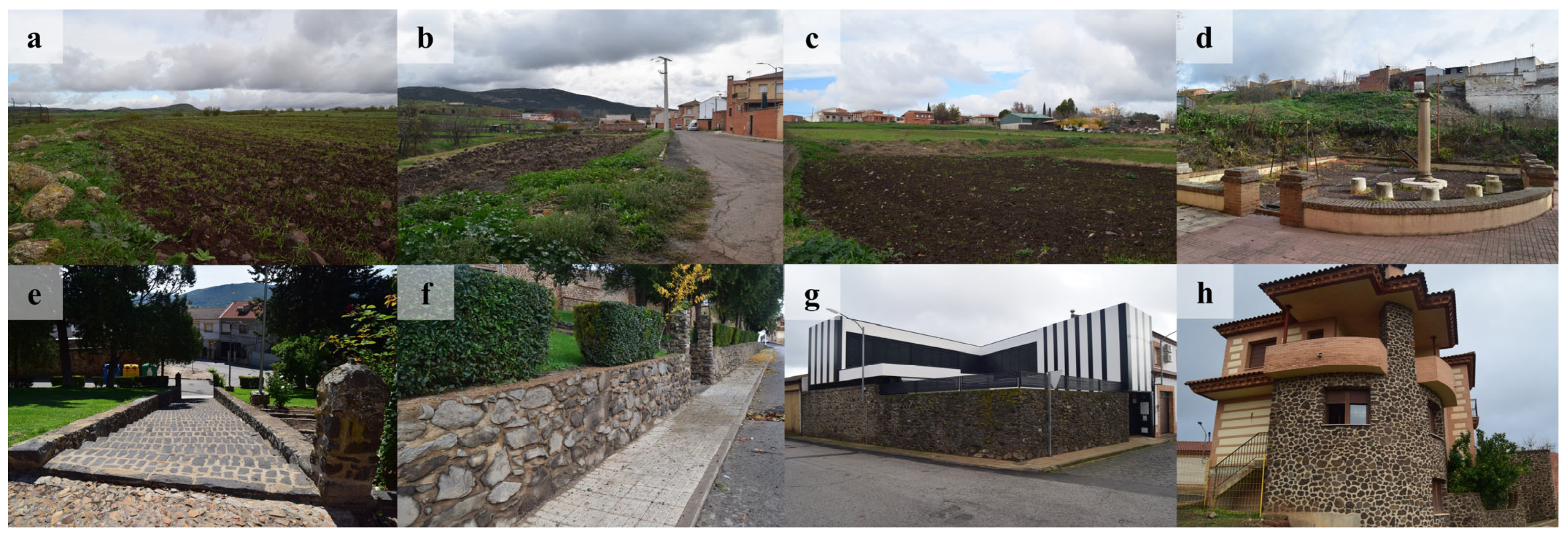
  • Sample of images and photographs.
  • Bibliographic references.

3.1. Assessment of the Geomorphological Heritage with Geotouristic Potential

To assess the geomorphological heritage interest of natural resources, the method developed by Serrano Cañadas & González-Trueba [44] and González-Trueba & Serrano-Cañadas [45] is used, which has been applied to the evaluation of geomorphosites to verify their validity as geotourism resources or SGIs, thus contributing to the local development of the territory. This methodology of the evaluation and inventory of geomorphosites, which is modified and includes specificities specific to volcanic territories in the doctoral work of Becerra-Ramírez [42], was applied to the cinder cones and spatter cones of the CCVR. It is the latter method that is used in this work, and the criteria and specificities outlined in previous studies applied to different volcanic areas were followed [46,47,48].
Although the basis of the method proposed by these authors is geomorphological, the present study considers other geoheritage resources of cultural interest, which are directly linked to residual volcanism or the socioeconomic use of the volcano itself. Therefore, the geoheritage evaluation was conducted through a semi-quantitative assessment of the characteristics of each resource, incorporating up to three sets of values, scientific value; cultural value; and the use, management, and protection value, resulting in the determination of its geotourism potential.
Scientific or intrinsic value (Sv) refers to the resource itself, meaning the inherent or natural features of the geomorphological elements. Sub-values are evaluated individually, including genesis, morphology, dynamics, chronology, lithology, and structures. The score ranges from 0 to 10, and the final score is a weighted average on a scale of 10.
Cultural or added value (Cv) refers to the historical, cultural, and environmental heritage that shapes and enriches the scientific values, which are present in the resource itself and/or its immediate surroundings. Sub-values such as landscape, cultural, educational, scientific, and tourist values are evaluated, along with ecological values related to protection figures and the degree of conservation. The scoring for some parameters ranges from 0 to 10, while others range from 0 to 5; however, the final score is weighted on a scale of 10.
The use, management, and protection value (UMPv) refers to territorial components and their potential for resource use and management beyond current use. Sub-values such as accessibility, fragility, vulnerability, intensity of use, risk of degradation, state of conservation, impacts, observation conditions, limits of change, and protection are evaluated, considering geoconservation. A qualitative designation based on three levels (2, 1, and 0) is used to assess the management potential. The final score is also based on the average weighting on a scale of 10.
Additionally, the scores for each resource are calculated, which will serve as indicative valuations for the subsequent geotouristic proposal. Subsequently, the geotouristic value (GTv) was determined by the result of the average weighting of the evaluated criteria (scientific or intrinsic, cultural or added, and use, management, and protection), as expressed in the following equation:
G T v = S v + C v + U M P v / 3
where Sv is scientific value, Cv is cultural value, and UMPv is use, management, and protection value.
Although resources related to tangible cultural heritage (immovable) are not directly subject to scientific evaluation, as they are not landforms themselves, they are defined by a lithological nature that characterizes them: the volcanic material. To determine their scientific value, the geological and geomorphological bases on which these resources are located are taken as a reference, such as the lava flows that shape the layout of the road network in the municipality of Piedrabuena.

3.2. Groups for the Geotourism Management of Geomorphological Heritage

In order to make a management proposal, it is necessary to categorise each resource based on its geoheritage interest and geotouristic potential. The group to which each resource belongs is determined by a combination of the average values of each of the three criteria (scientific, cultural, and use, management, and protection). The value obtained in the use, management, and protection criterion is taken as the reference to understand the orientation of uses, particularly towards geotourism.
It is assumed that all resources have at least a minimum level of geotouristic interest, so they are all designated as SGIs. In this way, resources with lower values are also included and can be interpreted as supporting and even as complementary attractions to the main ones. The proposed method outlines three qualitative classification intervals for the score obtained for each criterion: high (from 7.0 to 10 points), medium (from 3.5 to 6.9 points), or low (less than 3.5 points).
The evaluated natural and cultural resources of geotouristic interest (SGIs) were thus classified into four geotouristic management groups (Table 2, identified with uppercase letters A, B, C, and D) based on the average scores obtained in the use, management, and protection values (UMPv), combined with intrinsic (Sv) and added (Cv) values. This grouping was carried out with the aim of providing guidance on usage for each geotourism management group.

4. Results

For the Piedrabuena case study, a total of 12 SGIs were selected, 6 natural and 6 cultural SGIs, for inclusion in the urban geotourism itinerary. This selection considers their representativeness not only within the urban area but also the suburban context of the territory due to its proximity and connection to the city centre (Figure 4).
The selected SGIs are listed in Table 3, and all of them are a representative sample of the volcanic geodiversity of Piedrabuena in both its natural and cultural variants. The SIGs of the Piedrabuena and La Chaparra volcanoes (no. 01 and 02), along with the volcanic outcrop of the Sierra de La Cruz (no. 04), are examples of magmatic volcanism characterized mainly by strombolian and effusive dynamics, which correspond to the geomorphostructures of scoria cones and spatter cones [42]. The lava flows identified in Sancho Panza St. and La Cruz St. (no. 05 and 06) are related to different eruptive pulses and lava outpourings emitted by the Piedrabuena volcano, upon which the town is built. Moreover, hydromagmatic dynamics are represented by the Lucianego maar (no. 03), for which its origin is associated with a phreatic phenomenon that has resulted in a seasonal lagoon [41].
Ethnovolcanic resources are selected for the traditional use of volcanic rocks in historic–artistic, religious, and popular architecture within the urban centre [17] and not only for their value as cultural assets. The presence of volcanic material in the urban space of Piedrabuena is defined by its various uses, such as in construction (Mortara Castle, no. 07, and Na Sa de La Asunción Church, no. 08) and in street paving (cobblestones and pavements, no. 11). They are generally made from black basalt blocks sourced from quarries such as Los Escalones. The current uses are focused on the ornamentation and decoration of the urban space, due to the aesthetic qualities of volcanic stone (monolithic sculpture, no. 09, and the fountain of Los Jardincillos square, no. 10), and the low walls and adobe walls scattered throughout the municipality.
Table 3 also shows the scores obtained for all selected geotourism resources that were evaluated. It presents the average values for each of the three evaluation criteria (scientific, cultural, and use, management, and protection), thus determining their geotourism management group (A, B, C, or D) based on their geotouristic potential. As an orientation, the weighted geotouristic value (GTv) for the three criteria is also indicated, allowing for an objective comparison of different resources and an analysis of their feasibility for incorporation into the urban geotourism itinerary of Piedrabuena as either a major or minor resource.

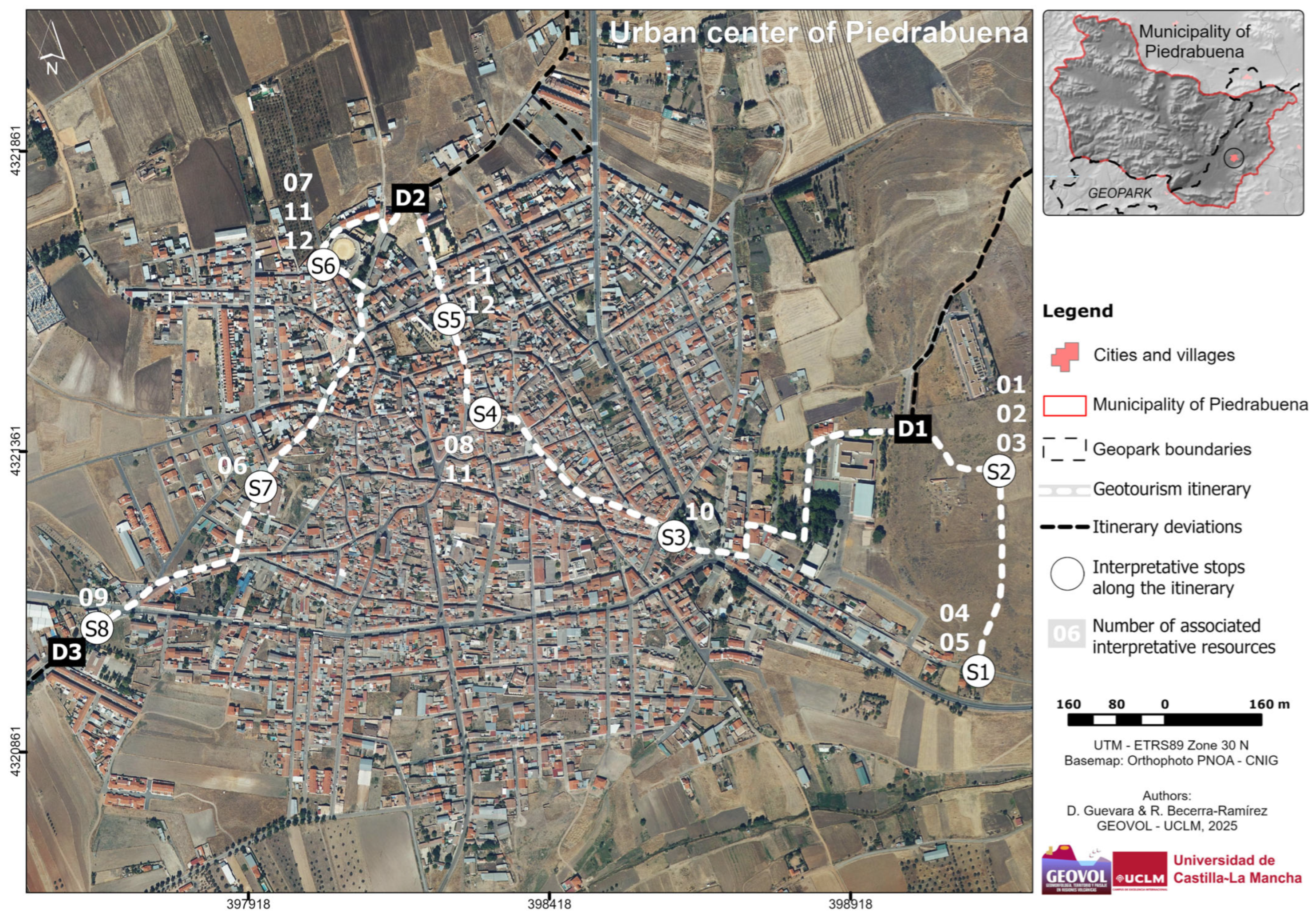
4.1. Sites of Geotouristic Interest (SGIs) of Piedrabuena

The Piedrabuena volcano Natural Monument (group A) is the main resource, with an average score of 7.1 and high geotouristic potential. It is complemented by six additional resources (B), such as the Mortara Castle (5.3), the Nuestra Señora de la Asunción Chruch (4.9), the fountain of Los Jardincillos square (4.8), the monolithic sculpture in the Tabla de la Yedra Park (4.8), the La Chaparra volcano (4.9), and the Lucianego maar (4.2), which have medium geotouristic potential. Those with lower scores correspond to two major supporting resources (C), such as cobblestones and pavement (3.5) and the Sierra de la Cruz outcrop (3.0), with medium/low geotouristic potential; and three minor resources (D), including low walls and adobe walls (2.8) and the lava flows of Sancho Panza St. (2.2) and de la Cruz St. (2.2), which would have relatively lower geotouristic potential.
In this sense, greater emphasis should be placed on the SGIs with the highest geotouristic potential (higher scores), but without diminishing the importance of those with lower scores, as they contribute to enriching and complementing the itinerary. More importantly, they help recognize and understand the use of the volcano throughout the history of the municipality, especially in the urban area.

4.2. Proposal of an Urban Geotourism Itinerary

Based on the results obtained for the urban centre of Piedrabuena and the need to enhance volcanic geotourism in the newly declared UNESCO Global Geopark Volcanes de Calatrava, Ciudad Real, it is necessary to create a volcanic–touristic experience linked to the volcano through an urban geotourism itinerary, which is the final part of the results and the goal of this work. This itinerary has a geographical theme with a primarily touristic orientation, but it is also educational and informative and takes place within the Piedrabuena urban area (Figure 5). It connects all the identified and valued resources, considering their geomorphological heritage evaluation, proximity to the urban area, and current conservation status.
As it is an urban itinerary, general aspects from other authors for cities like Lisbon [49,50], Pruszków (Poland) [51], Segovia [15], or Burgos [16], as well as the particularities of cities in volcanic territories, such as Naples and Rome [52,53] (Italy), Clermont-Ferrand (France) [54], and Torres (Brazil) [55], should be considered. The examples of georoutes or itineraries proposed in the Canary Islands (Spain), like Puerto de la Cruz, Icod de Los Vinos [18], Garachico [19], Cidade Velha (Cape Verde) [20], or Ciudad Real (Spain) [28], can serve as references. These itineraries all have a spatial theme, as they traverse linear elements (streets or lava flows) while considering the interrelation of resources.
A linear urban geotourism itinerary is defined based on a previous experience carried out by geographers from the GEOVOL research group at the University of Castilla-La Mancha during the science outreach event Volcanoes’ Night 2015 (European Researchers’ Night) [56]. The itinerary is accessible to all visitors or tourists, with easy accessibility and low difficulty. It consists of eight stops along a 4 km route, where 12 SGIs can be visited, taking approximately two and a half hours. Additionally, on the map, alternative or secondary routes are indicated, which can be taken to visit and interpret other resources (identified with the letter D): the Piedrabuena volcano Natural Monument (D1), the socioeconomic use of quarries (D2), and the residual volcanism of the area, with the best example being the natural site of Fuente Agria (D3) (Figure 5).
The interrelation of the different SGIs within the urban centre facilitates the understanding of the main attraction of this itinerary, which is the use of volcanic rocks in the urban landscape visible in different buildings (monuments, churches, private houses, cobblestones, etc.). Some key points in the municipality are highlighted, where visitors can observe the front and cuts of the lava flows from the Piedrabuena and La Chaparra, the volcanoes closest to the urban area, and the eruptive phases that formed the different morphologies (cones and lava flows), alongside monuments or cultural manifestations that have used volcanic rocks. An interesting slogan that could be used to implement this urban geotourism itinerary, connecting the use of volcanic material and the history of the territory, would be “Volcanoes and Petra Bona”: it links the volcanic past of the landforms and landscape with the Roman origin of the occupation of the territory.

5. Discussion

The existence of the Piedrabuena volcano has long been known to its population, and numerous descriptions of it have been attributed to Hernández-Pacheco [57], who, as early as 1932, referred to the volcano as a “steep hill (…) [and spoke of] carbonic water springs (…) which are called (…) sour or acid springs [scattered across] one of the largest patches, formed by the eruptive rocks of the region” (pp. 129–133), referring to its significance within the CCVR.
The Piedrabuena Volcano is currently designated as a Natural Monument under the provisions of Decree 25/2009 issued by the Government of Castilla-La Mancha [58]. This is in accordance with Law 9/1999 on the Conservation of Nature [59] within this autonomous region of Spain, which aims to ensure the conservation of the volcano, its dynamics, and ecosystems. It also aims to restore degraded natural resources (such as debris dumping), facilitate understanding of its geology, raise public awareness, and promote research related to its geoconservation.
This area is part of the UNESCO Global Geopark Volcanes de Calatrava, Ciudad Real, which is overseen by geographers from the GEOVOL research group at the Universidad de Castilla-La Mancha and managed by the Provincial Council of Ciudad Real. The goal is for its geological, geomorphological, and cultural heritage to achieve international recognition, as it is the most significant area within the internationally important geological context of the Neogene–Quaternary volcanism of the Iberian Peninsula (listed in Annex VIII-2 of Law 33/2015, which modifies Law 42/2007 on Natural Heritage and Biodiversity [60]), alongside the mercury mineralization of the Almadén region (the most important geological context in Spain) and the Carboniferous of Puertollano, which are both formed by paleovolcanism [29].
In this context, volcanic tourism is emerging as a primary activity in this region, thanks to the various volcanic resources that exist in the historical–cultural and natural region of Campo de Calatrava. The development of georoutes and itineraries, the practice of adventure and risky sports and bird watching, visitor centres, and others within the UNESCO Global Geopark are some of the notable initiatives that have contributed to this growth [29].
So far, the Geopark Volcanes de Calatrava, Ciudad Real, has established a network of 10 official georoutes connecting several geosites integrated into the volcanic landscape out of the 31 official sites open to the public. These georoutes are long in distance (more than 10 kilometres) [61] and make use of existing basic infrastructure, such as local roads, some sections of the cattle paths (Cañadas Reales Segoviana and Soriana Oriental) that were used as the official network of trails by the Provincial Council of Ciudad Real (now declassified), and other tourist routes such as the Rocinante route (Asociación de Desarrollo Valle de Alcudia), the Don Quixote route (Castilla-La Mancha Government), and the Caminos Naturales route (Spanish Government).
As noted by Becerra-Ramírez et al. [29], the promotion of geotourism activities is making this territory a diversified and dynamic space, gaining increasing support and interest from society, businesses, and local government. The goal is to foster sustainable economic development in accordance with the United Nations Sustainable Development Goals for 2030 [8].
The geomorphological features of Piedrabuena are important for scientific, educational, and tourist activities. Among the proposed actions are the following: the promotion of environmental education, outreach, and guide training; the creation of new tourist infrastructures (visitor centres and viewpoints); the recovery and conditioning of sour springs and thermal baths; the design of new itineraries and georoutes; and even the promotion of local products under the volcano brand.
In Ruiz-Pedrosa et al.’s research [62], it is affirmed that georoutes are a key resource for the geotouristic diversification of any territory, as they combine leisure and education, allowing for an understanding of both natural (geoheritage) and cultural heritage. For Piedrabuena, three itineraries have been devised for trail running, a sustainable activity promoted by the Trail Running Centre Entre Volcanes. Other notable initiatives within the municipality are the conditioning of the carbonic sour water fountain (“fuente agria” in Spanish) and the San Isidro Bath, with the former being declared a public and minero-medicinal utility in 1869 [63] (Figure 6). In addition, there is the promotion of the Cruces y Mayos festival, declared to be of regional interest, in relation to the presence of volcanic material in this territory.
Geotouristic diversification in volcanic areas is not new in Spain. Indeed, the Canary Islands serve as a prime example, with tourism development being inextricably linked to initiatives such as the Volcanic Experience tourist programme. This form of tourism is gaining importance in other parts of southern and central Europe, as evidenced by the ecotourism industry in volcanic lagoons or the Eifel region (Germany) and the Auvergne region (France), where it is possible to observe over 80 volcanic buildings and visit the city of Clermont-Ferrand, with its Gothic cathedral built from volcanic rock [54], alongside a visit to the Vulcania theme park [64]. Additionally, the region of Cappadocia (Turkey) is famous for the observation of volcanic chimneys in hot air balloons.

6. Conclusions

The municipality of Piedrabuena has a population of just over 4000 inhabitants, and its urban core, like other municipalities in Castilla-La Mancha, is characterized by significant deterioration due to population loss, ageing, and economic stagnation. However, its situation has not always been the same from a tourist perspective. Until well into the 20th century, the recreational and natural bathing area of Tabla de la Yedra, located on the Bullaque river (a tributary of the Guadiana), was of great interest. Similarly, the region’s rich hunting traditions contributed to Piedrabuena’s desirability, making it a highly sought-after location within the Montes de Ciudad Real region. The area’s historical and cultural heritage, marked by Roman and Muslim influences, is further highlighted by architectural vestiges such as castles, roads, and caves in the northern part of the municipality.
Piedrabuena is located in the northwestern sector of the CCVR, and only a small sector of the municipality, the eastern sector, is within the boundaries of the UNESCO Global Geopark Volcanes de Calatrava, Ciudad Real. Geotourism, in general, and volcanic tourism, in particular, already exist in the territorial context of the entire region. Thus, its geotouristic offering can be complemented by visits to protected natural areas of volcanic origin (natural monuments, microreserves, and nature reserves) and museums or visitor centres, such as the interpretation centre of the Cerro Gordo volcano (Granátula de Calatrava) or the interpretation centre of Agua Volcánica La Inesperada (Pozuelo de Calatrava).
The Piedrabuena volcano Natural Monument stands out as one of the main attractions in the offering of sustainable volcanic tourism. However, it is important to note that the actions of some local managers are not fully aligned with the conservation, protection, and sustainability goals specified by the Law of Nature Conservation of Castilla-La Mancha [59], as well as the principles of geoparks. There is, nevertheless, ongoing support from the Local Action Group, Asociación de Desarrollo Cabañeros y Entreparques (previously Montes Norte), which promotes activities contributing to the consolidation of the UNESCO Global Geopark Volcanes de Calatrava, Ciudad Real.
The proposal for a geotourism itinerary in the urban area of Piedrabuena is in line with all points discussed above. The itinerary covers a 4 km route, with up to eight stops, where twelve geotouristic resources can be considered sites of geotouristic interest (SGIs) linked to the volcanic phenomenon in the municipality. This interpretation can be approached from a general geographic perspective or a more specific thematic perspective by considering different criteria: intrinsic, value added, or use, management, and protection. When implementing the urban itinerary, a number of limitations may be encountered, particularly in terms of the willingness of the local administration and the geopark management body to put this proposal into practice. The itinerary would need to be put on paper (brochures) or digital format (smartphones, tablets, and GPS), and information panels should be installed to indicate the geotourism resources on offer. However, tourist guides and geopark staff, as well as teachers at all levels, can use this proposal to develop tourist, educational, and informative activities. The slogan “Volcanoes and Petra Bona” could be used to link the Roman origins of Piedrabuena with the exploitation of the volcanic resources of this territory.
The objective of this initiative is to promote economic diversification within the local context, with the intention of leveraging the region’s primary natural asset, namely the Piedrabuena volcano, as a foundation for a novel leisure proposition. In this respect, it is recommended that the municipal authorities maintain their commitment to the creation, design, and promotion of tourist products under the volcano brand. This strategy has the potential to stimulate economic growth in the local area, thereby complementing the existing array of annual religious activities and festivals, including the San Isidro pilgrimage or the Cruces y Mayos festival.
Based on the findings of this study, it is necessary to implement a methodology at a regional scale. The implementation of such a methodology would facilitate a better understanding of the society–volcano relationship through the SGIs while promoting proximity tourism within the Iberian Peninsula. This tourism model, founded on geoheritage and its connection to cultural heritage, has the potential to stimulate economic revitalisation in rural regions. It can also encourage future studies focused on the geotouristic development of the CCVR and the entire territory that is part of the geopark.
UNESCO establishes that Global Geoparks play an important role in developing their three main lines of action: geotourism, geoeducation, and geoconservation [65]. Educational programs, projects, and infrastructure [39,40] are key to fostering knowledge of the territory, as demonstrated by successful cases such as the Costa Vasca Geopark (Spain) and its Geoeskolak program or the Orígens Geopark in the Catalan Pyrenees (Spain), which creates immersive experiences using 4D geological reconstructions. CCVR is also the subject of educational proposals that promote the creation of educational itineraries [66] and the development of specific programs by the local administration, like Vulcano [61] or Un Paseo Escolar (“A School Walk”) [67], in relation to this geopark. Guevara [68] also developed a specific educational proposal for secondary schools in the CCVR, aiming to provide teachers with tools and resources to engage students with the volcanic territory.
With the growing commitment to volcanic tourism by local authorities and businesses, the UNESCO Global Geopark Volcanes de Calatrava, Ciudad Real, is already a reality. For this reason, the aim is to continue investing in the geotouristic dynamization of this territory through the development of tourist products and the creation of volcano-tourism experiences to further contribute to the consolidation of this area as a way of conserving the geomorphological heritage values of the territory.

Author Contributions

Conceptualization, D.G., R.B.-R. and J.D.-P.; methodology D.G. and R.B.-R.; software, D.G.; validation, D.G., R.B.-R., J.D.-P. and E.E.; formal analysis, D.G. and R.B.-R.; investigation, D.G., R.B.-R. and E.E.; resources, D.G., R.B.-R. and E.E.; writing—original draft preparation, D.G. and R.B.-R.; writing—review and editing, D.G., R.B.-R., J.D.-P. and E.E.; visualization, D.G., R.B.-R. and J.D.-P.; supervision, R.B.-R.; project administration, R.B.-R.; funding acquisition, R.B.-R. and E.E. All authors have read and agreed to the published version of the manuscript.

Funding

This work is part of the research activity within the research contract of the INVESTIGO Program, under the framework of the Recovery, Transformation, and Resilience Plan (Research Call 2022-C23-I01.P03.S0020-0000618) funded by Next Generation EU funds and developed at the Universidad de Castilla-La Mancha (Ref.: 2023-INVGO-11924). The fieldwork conducted is part of the project Identification of geosites and design of routes in volcanic geoparks to enhance volcanic tourism: Geopark of El Hierro, La Palma (Canary Islands) and the Ciudad Real Geopark project (Castilla-La Mancha) (funded by departmental research funds in 2023 and 2024, Departamento de Geografía y Ordenación del Territorio, Universidad de Castilla-La Mancha). The English review of this article was funded by the Departamento de Geografía y Ordenación del Territorio, Universidad de Castilla-La Mancha (Spain).

Data Availability Statement

The original data presented in the study are openly available and can be accessed both within this paper and upon request from the corresponding author.

Acknowledgments

We want to thank Agnès Louart Traducciones for their translation services and the reviewers who carried out revisions, contributing to improving the final version of this work and its publication.

Conflicts of Interest

The authors declare no conflicts of interest.

Abbreviations

The following abbreviations are used in this manuscript:
CCVRCampo de Calatrava Volcanic Region.
GEOVOLResearch Group “Geomorfología, Territorio y Paisaje en Regiones Volcánicas”—Departamento de Geografía y Ordenación del Territorio, Universidad de Castilla-La Mancha (Spain).
MAGNA50Mapa Geológico Nacional—1:50,000 scale (Instituto Geológico y Minero de España, Ministerio de Ciencia, Innovación y Universidades, Spain).
MTN25Mapa Topográfico Nacional—1:25,000 scale (Instituto Geográfico Nacional, Ministerio de Transportes y Movilidad, Spain).
MTN50Mapa Topográfico Nacional—1:50,000 scale (Instituto Geográfico Nacional, Ministerio de Transportes y Movilidad, Spain).
PNOAPlan Nacional de Ortofotografía Aérea (Instituto Geográfico Nacional, Ministerio de Transportes y Movilidad, Spain).
SGIsSites of Geotouristic Interest.
UNESCOUnited Nations Educational, Scientific and Cultural Organization.

References

  1. Álvarez, A. El ciclo de la vida de los destinos turísticos litorales. In Turismo y Territorio en la Sociedad Globalizada; Álvarez, A., Hernández, J., Simancas Cruz, M., Eds.; Ayuntamiento de Adeje-Instituto Pascual Madoz del Territorio, Urbanismo y Medio Ambiente, University of Carlos III: Adeje, Spain, 2004; pp. 123–155. [Google Scholar]
  2. Corral, S.; Hernández, J. El turismo en destinos maduros archipielágicos: Condicionantes y estrategias. El caso de los “tres grandes”: Hawái, Canarias, Baleares. In Destinos Turísticos Maduros Ante el Cambio: Reflexiones Desde Canarias; Hernández, R., Santana, A., Eds.; Instituto Universitario de Ciencias Políticas y Sociales, University of La Laguna: La Laguna, Spain, 2010; pp. 161–182. [Google Scholar]
  3. Hernández, R.; Santana, A. Destinos Turísticos Maduros Ante el Cambio: Reflexiones Desde Canarias; Instituto Universitario de Ciencias Políticas y Sociales, University of La Laguna: La Laguna, Spain, 2010. [Google Scholar]
  4. Simancas Cruz, M.; De Souza Iglesias, A.; Núñez Caño, M. La renovación de los espacios públicos en áreas turísticas consolidadas. In Destinos Turísticos Maduros Ante el Cambio Climático: Reflexiones Desde Canarias; Hernández, R., Santana, A., Eds.; Instituto Universitario de Ciencias Políticas y Sociales, University of La Laguna: La Laguna, Spain, 2010; pp. 183–213. [Google Scholar]
  5. Pillet Capdepón, F. El turismo de interior y el patrimonio territorial en Castilla-La Mancha. Cuad. Tur. 2011, 27, 725–741. [Google Scholar]
  6. Pillet Capdepón, F. El turismo de interior en la España peninsular: El patrimonio territorial como destino turístico. Bol. La Asoc. Geogr. Esp. 2012, 59, 345–366. [Google Scholar] [CrossRef]
  7. Cañizares Ruiz, M.C. Paisaje, patrimonio e identidad territorial: Claves históricas y desafíos actuales. In Nature, Territory and City in a Global World, Proceedings of the 25th Congress of the Association of Spanish Geographers, Madrid, Spain, 25–27 October 2017; Allende Álvarez, F., Cañada Torrecilla, R., Fernández Mayoralas, G., Gómez Mediavilla, G., López Estébanez, N., Palacios García, A., Rojo Pérez, F., Vidal Domínguez, M.J., Eds.; Autonomous University of Madrid Ediciones: Madrid, Spain, 2017; pp. 1725–1742. [Google Scholar]
  8. Sustainable Development Goals. Available online: https://www.un.org/sustainabledevelopment/ (accessed on 8 May 2025).
  9. Geoparques de España. Available online: https://geoparques.es/ (accessed on 13 May 2025).
  10. Lanza Digital. La UNESCO Designa 18 Nuevos Geoparques. 27 March 2024. Available online: https://unes.co/31dxs2 (accessed on 14 May 2025).
  11. Carcavilla, L.; Belmonte, A.; Durán, J.; Hilario, A. Geoturismo: Concepto y perspectivas en España. Ensen. Las Cienc. Tierra 2011, 19, 81–94. [Google Scholar]
  12. Newsome, D.; Dowling, R. Global Geotourism Perspectives; Goodfellow Publishers: Oxford, UK, 2010. [Google Scholar]
  13. Dowling, R.; Newsome, D. Handbook of Geotourism; Edward Elgar Publishing: Cheltenham, UK, 2018. [Google Scholar]
  14. Diez Herrero, A.; Vegas, J. De Roca a Roca. Descubre el Patrimonio Geológico de la Ciudad de Segovia; Concejalía de Turismo: Segovia, Spain, 2011. [Google Scholar]
  15. Diez Herrero, A.; Vegas, J. Itinerarios geoturísticos por la provincia de Segovia. La gestión de su patrimonio geológico. In Proceedings of the 10th National Meeting of the Geological Heritage Commission of the Geological Society of Spain, Segovia, Spain, 10–15 June 2013; Instituto Geológico y Minero de España, Diputación de Segovia: Segovia, Spain, 2013. [Google Scholar]
  16. Fernández Martínez, E.; Barbadillo, P.; Castaño de Luis, R.; Marcos, A.; Preciado, J.; Serrano, E. Geoturismo en la Ciudad de Burgos: Una Guía de Geología Urbana Para todos los Públicos; Ayuntamiento de Burgos: Burgos, Spain, 2012. [Google Scholar]
  17. Escobar, E. Aprovechamiento de los Recursos Volcánicos: Mediterráneo Central (Italia Peninsular), Mediterráneo Occidental (Campo de Calatrava) y Entorno Atlántico (Islas Canarias). Ph.D. Thesis, University of Castilla-La Mancha, Ciudad Real, Spain, 2015. Available online: http://hdl.handle.net/10578/10572 (accessed on 24 June 2025).
  18. Dóniz-Páez, J.; Quintero Alonso, C. Propuesta de geoturismo urbano en Icod de los Vinos (Tenerife, Islas Canarias, España). Cuad. Geogr. 2016, 55, 1–24. [Google Scholar]
  19. Dóniz-Páez, J.; Becerra-Ramírez, R.; Carballo-Hernández, M. Propuesta de itinerario geoturístico urbano en Garachico (Tenerife, Canarias, España). Investig. Geogr. 2016, 66, 95–115. [Google Scholar] [CrossRef]
  20. Dóniz-Páez, J.; Veiga-Pereira, J.; Becerra-Ramírez, R.; González, E.; Escobar, E. Inventario e itinerario para geoturismo urbano en Ciudade Velha (Isla de Santiago, República de Cabo Verde). In Patrimonio Geológico, Gestionando la Parte Abiótica del Patrimonio natural, Proceedings of the 12th National Meeting of the Geological Heritage Commission of the Geological Society of Spain, Menorca, Spain, 6–10 June 2025; Carcavilla, L., Duque-Macías, J., Jiménez, J., Hilario, A., Monge-Ganuzas, M., Rodríguez, A., Eds.; Cuadernos del Museo Geominero; Instituto Geológico y Minero de España: Madrid, Spain, 2025; Volume 21, pp. 267–276. [Google Scholar]
  21. Suárez-Francisco, J.S.; Pérez Pérez, J.; Hernández, W.; Dóniz-Páez, J. Geoturismo urbano en Vilaflor de Chasna (Tenerife, Canarias, España). In Los Procesos de Globalización en el Atlántico, Proceedings of the 24th Colloquium on Canarian-American History, Las Palmas de Gran Canaria, Spain, 3 December 2020; Casa de Colón: Las Palmas de Gran Canaria, Spain, 2020; pp. 24–113. [Google Scholar]
  22. Hernández, W.; Dóniz-Páez, J.; Hernández, P.A.; Pérez, N.M. Itinerario de geoturismo urbano en Santiago del Teide (Tenerife, Canarias, España). Gran Tour. Rev. Investig. Tur. 2021, 23, 200–221. [Google Scholar]
  23. Hernández, W.; Dóniz-Páez, J.; Pérez, N.M. Urban Geotourism in La Palma, Canary Islands, Spain. Land 2022, 11, 1337. [Google Scholar] [CrossRef]
  24. Moscardo, G. Interpretation, culture and the creation of place. Tour. Recreat. Res. 2007, 32, 57–64. [Google Scholar] [CrossRef]
  25. Marjanović, M.; Marković, R.; Šarić, K.; Radivojević, A.R.; Antić, A.; Raičević, D.; Schaetzl, R.J.; Marković, S.B. Geotouristic Approach to the Elements of Geocultural Heritage by Using UGAM Model: UNESCO World Heritage Site Felix Romuliana (Zaječar, Serbia). Geoheritage 2024, 16, 35. [Google Scholar] [CrossRef]
  26. Fernández-Martínez, E.; Castaño de Luis, R. Avances y Retos en la Conservación del Patrimonio Geológico en España; University of León: León, Spain, 2011. [Google Scholar]
  27. Reynard, E.; Pica, A.; Coratza, P. Urban geomorphological heritage. An overview. Quaest. Geogr. 2017, 36, 7–20. [Google Scholar] [CrossRef]
  28. Gosálvez, R.U.; Becerra-Ramírez, R.; Escobar, E.; González, E.; Dóniz-Páez, J. Los maares de Ciudad Real: Una propuesta de georruta urbana en el marco del Proyecto de Geoparque Volcanes de Calatrava. Ciudad Real. In Geografía, Cambio Global y Sostenibilidad. Comunicaciones del XXVII Congreso de la Asociación Española de Geografía; García Rodríguez, J.L., Ed.; Asociación Española de Geografía and University of La Laguna: La Laguna, Spain, 2021; pp. 995–1010. [Google Scholar]
  29. Becerra-Ramírez, R.; Gosálvez, R.U.; Escobar, E.; Serrano-Patón, M.; Guevara, D. Characterization and Geotourist Resources of the Campo de Calatrava Volcanic Region (Ciudad Real, Castilla-La Mancha, Spain) to Develop a UNESCO Global Geopark Project. Geosciences 2020, 10, 441. [Google Scholar] [CrossRef]
  30. Becerra-Ramírez, R.; Dóniz-Páez, J.; González, E. Morphometric Analysis of Scoria Cones to Define the ‘Volcano-Type’ of the Campo de Calatrava Volcanic Region (Central Spain). Land 2022, 11, 917. [Google Scholar] [CrossRef]
  31. García, J.L. Mapa Geomorfológico de la Comarca de Los Montes-Campo de Calatrava: E: 1:200,000; University of Castilla-La Mancha: Madrid, Spain, 1994. [Google Scholar]
  32. González, E. Geomorfología de los edificios volcánicos del borde occidental del Campo de Calatrava: La cubeta de Piedrabuena. In Entre la Cruz y Miraflores. Piedrabuena, Espacio Histórico y Cultural; Alía Miranda, F., Ed.; Ayuntamiento de Piedrabuena: Piedrabuena, Spain, 2003; pp. 405–420. [Google Scholar]
  33. Poblete, M.A. Las últimas manifestaciones asociadas al volcanismo del Campo de Calatrava (Ciudad Real): Los manantiales termales. Cuadernos de Sección. Hist. Geogr. Homen. Féliz María Urgarte 1992, 20, 187–201. [Google Scholar]
  34. Poblete, M.A. El Relieve Volcánico del Campo de Calatrava (Ciudad Real); Junta de Comunidades de Castilla-La Mancha, University of Oviedo: Oviedo, Spain, 1995. [Google Scholar]
  35. Alía Miranda, F. Entre la Cruz y Miraflores: Piedrabuena, Espacio Histórico y Natural; Ayuntamiento de Piedrabuena: Piedrabuena, Spain, 2003.
  36. Alía Miranda, F.; Sánchez Fernández, P. Piedrabuena y Su Entorno. Arte, Antropología, Historia y Espacios Naturales; Ayuntamiento de Piedrabuena: Piedrabuena, Spain, 2006.
  37. Vera Rebollo, J.; López Palomeque, F.; Marchena Gómez, M.; Antón i Clavé, S. Análisis Territorial del Turismo y Planificación de Destinos Turísticos; Tirant Lo Blanch: Valencia, Spain, 2011. [Google Scholar]
  38. Faccini, F.; Giardino, M.; Paliaga, G.; Luigi Perotti, L.; Brandolini, P. Urban geomorphology of Genoa old city (Italy). J. Maps 2020, 17, 51–64. [Google Scholar] [CrossRef]
  39. Brilha, J. Inventory and quantitative assessment of geosites and geodiversity sites: A review. Geoheritage 2016, 8, 119–134. [Google Scholar] [CrossRef]
  40. Guilbaud, M.N.; Ortega-Larrocea, M.d.P.; Cram, S.; van Wyk de Vries, B. Xitle Volcano Geoheritage, Mexico City: Raising Awareness of Natural Hazards and Environmental Sustainability in Active Volcanic Areas. Geoheritage 2021, 13, 6. [Google Scholar] [CrossRef]
  41. Gosálvez, R.U. Análisis Biogeográfico de las Lagunas Volcánicas de la Península Ibérica. Ph.D. Thesis, University of Castilla-La Mancha, Ciudad Real, Spain, 2011. Available online: http://hdl.handle.net/10578/3246 (accessed on 24 June 2025).
  42. Becerra-Ramírez, R. Geomorfología y Geopatrimonio de los Volcanes Magmáticos de la Región Volcánica del Campo de Calatrava. Ph.D. Thesis, University of Castilla-La Mancha, Ciudad Real, Spain, 2013. Available online: http://hdl.handle.net/10578/3606 (accessed on 24 June 2025).
  43. Navarro, D. Recursos y atractivos turísticos: Conceptualización, clasificación y valoración. Cuad. Tur. 2015, 35, 335–357. [Google Scholar] [CrossRef]
  44. Serrano Cañadas, E.; González-Trueba, J.J. Assessment of geomorphosites in projected natural áreas: The Picos de Europa National Park (Spain). Geomorphologie 2005, 3, 197–208. [Google Scholar] [CrossRef]
  45. González-Trueba, J.J.; Serrano Cañadas, E. La valoración del patrimonio geomorfológico en espacios naturales protegidos. Su aplicación al Parque Nacional de los Picos de Europa. Bol. Asoc. Geogr. Esp. 2008, 47, 175–194. [Google Scholar]
  46. Pérez-Umaña, D.; Quesada-Román, A.; Zangmo Tefogoum, G. Geomorphological heritage inventory of Irazú Volcano, Costa Rica. Int. J. Geoheritage Parks 2020, 8, 31–47. [Google Scholar] [CrossRef]
  47. Ziem, A.; Bidias, L.A.; Mouchili Nguegni, S.; Ilounga, D.C.I.; Kenna, H.S.; Moundi, A.; Kamgang, P. Geomorphological component of volcanic geoheritage of Kouoptamo, Cameroon Volcanic Line: Geoconservation and Perspectives for geotourism industry. Int. J. Geoheritage Parks 2023, 11, 365–384. [Google Scholar] [CrossRef]
  48. Carrión-Mero, P.; Sánchez-Zambrano, E.; Mata-Perelló, J.; Joya-Montalvo, M.; Herrera-Franco, G.; Berrezueta, E.; Espinel, R.L.; Baque, M.; Morante-Carballo, F. Geosites assessment in a volcanic hotspot environment and its impact on geotourism, Santa Cruz,-Galapagos, Ecuador. Int. J. Geoheritage Parks 2024, 12, 147–167. [Google Scholar] [CrossRef]
  49. Caetano, P.S.; Patuleia, M.; Ferreira, M.I.M. Entre a superficie e o subterráneo: Proposta de percursos geoturísticos urbanos em Lisboa. Encontros Cient. Tour. Manag. 2011, 1, 426–437. [Google Scholar]
  50. Rodrigues, M.L.; Machado, C.; Freire, E. Geoturism routes in urban areas: A preliminary approach to the Lisbon geoheritage survey. Geo. J. Tour. Geosites 2011, 2, 281–294. [Google Scholar]
  51. Górska-Zabielska, M.; Zabielski, R. Stone and urban space—Its potential to promote geotourism. Geo. J. Tour. Geosites 2019, 26, 1033–1045. [Google Scholar] [CrossRef]
  52. Morra, V.; Calcaterra, D.; Cappelletti, P.; Colella, A. Urban geology: Relationships between geological setting and architectural heritage of Neapolitan area. J. Virtual Explor. 2010, 36, 60. [Google Scholar] [CrossRef]
  53. Del Monte, M.; Fredi, P.; Vergari, F.; Pica, A. Geosites within Rome City center (Italy): A mixture of cultural and geomorphological heritage. Geogr. Fis. Din. Quat. 2013, 36, 241–257. [Google Scholar] [CrossRef]
  54. Vereb, V.; van Wyk de Vries, B.; Guilbaud, M.N.; Karátson, D. The urban geoheritage of Clermont-Ferrand: From inventory to management. Quaest. Geogr. 2020, 39, 5–31. [Google Scholar] [CrossRef]
  55. Zerfass, H.; de Santana dos Anjos-Zerfass, G.; Ruban, D.; Yashalova, N. Basalt hills of Torres, southern Brazil: World-class geology, its heritage value, and tourism perspectives. J. S. Am. Earth Sci. 2020, 97, 102424. [Google Scholar] [CrossRef]
  56. Lanza Digital. La Noche de los Volcanes, una Oportunidad de Descubrir el Vulcanismo de Ciudad Real. 19 September 2015. Available online: https://www.lanzadigital.com/cultura/la-noche-de-los-volcanes-una-oportunidad-de-descubrir-el-vulcanismo-de-ciudad-real/ (accessed on 13 May 2025).
  57. Hernández-Pacheco, F. Estudio de la Región Volcánica Central de España; Memoria de la Academia de Ciencias Exactas; Físicas y Naturales: Madrid, Spain, 1932. [Google Scholar]
  58. Decreto 25/2009, De 31/03/2009, por el que se Declara Monumento Natural el Volcán de Piedrabuena, en el Término Municipal de Piedrabuena, Provincia de Ciudad Real. Available online: https://docm.jccm.es/docm/eli/es-cm/d/2009/03/31/25 (accessed on 8 May 2025).
  59. Ley 9/1999, De 26 de Mayo, de Conservación de la Naturaleza de Castilla-La Mancha. Available online: https://www.boe.es/eli/es-cm/l/1999/05/26/9/con (accessed on 8 May 2025).
  60. Ley 42/2007, De 13 de Diciembre, del Patrimonio Natural y de la Biodiversidad. Available online: https://www.boe.es/buscar/act.php?id=BOE-A-2007-21490 (accessed on 8 May 2025).
  61. Geoparque UNESCO ‘Volcanes de Calatrava. Ciudad Real’. Available online: https://geoparquevolcanesdecalatrava.es/ (accessed on 8 May 2025).
  62. Ruiz-Pedrosa, R.M.; González-Amuschástegui, M.J.; Serrano, E. Geomorphosites as Geotouristic Resources: Assessment of Geomorphological Heritage for Local Development in the Río Lobos Natural Park. Land 2024, 13, 128. [Google Scholar] [CrossRef]
  63. Lanza Digital. El Agua Agria de Piedrabuena Es un “Bien de Utilidad Pública” Desde Finales del Siglo XIX por Sus Propiedades Medicinales. 14 May 2022. Available online: https://www.lanzadigital.com/provincia/el-agua-agria-de-piedrabuena/?fbclid=IwAR0v3kThDll-0jK%20%20H_4nJ-YUa4qAGa5NEVLBTjgpFD_Xs1aHik_eIt6kDlcQ (accessed on 14 May 2025).
  64. Erfurt-Cooper, P. (Ed.) Volcanic Tourist Destinations; Springer: London, UK, 2014. [Google Scholar]
  65. UNESCO. Available online: https://www.unesco.org/es/iggp/geoparks/about (accessed on 13 May 2025).
  66. González, E.; Gosálvez, R.U.; Escobar, E.; Becerra-Ramírez, R. Volcanes. El Latido del Campo de Calatrava; Lafarge Cementos SAU: Villaluenga de la Sagra, Spain, 2013. [Google Scholar]
  67. Diputación de Ciudad Real: Un Paseo Escolar. Available online: https://www.dipucr.es/documentos-servicio-cultura/unpaseoescolar (accessed on 8 May 2025).
  68. Guevara, D. Los geoparques en las aulas de Secundaria y Bachillerato. Una propuesta didáctica en torno al Geoparque UNESCO ‘Volcanes de Calatrava. Ciudad Real’. In Geografía, Educación e Innovaciones Didácticas; Marrón Gaite, M.J., Ed.; Asociación Española de Geografía, Grupo de Didáctica: Madrid, Spain, 2024; pp. 266–277. [Google Scholar]
Figure 1. Location of the municipality of Piedrabuena in the geological context of the Campo de Calatrava Volcanic Region and the Global Geopark Volcanes de Calatrava, Ciudad Real. Geological basemap at 1:1,000,000 scale, from the Instituto Geológico y Minero de España (IGME). Self-elaboration.
Land 14 01363 g001
Figure 2. Urban centre of Piedrabuena adapted to the topography of the lava flows.
Land 14 01363 g002
Figure 3. Agronomic and urban uses of volcanic rock in Piedrabuena: (a) Negrizal (blackish soil) on La Arzollosa St. (b) Negrizal (blackish soil) on Juan de Austria St. (c) Negrizal (blackish soil) on El Cerro St. (d) Volcanic gravel on Cruz St. (e) Pavement on De los Toreros St. (f) Masonry on De los Toreros St. (g) Modern house on Ruperto Villaverde St. (h) Modern house on De los Toreros St.
Land 14 01363 g003
Figure 4. Geotourism resources associated with the volcanic geoheritage of Piedrabuena: (a) Piedrabuena Volcano Natural Monument; (b) La Chaparra volcano; (c) Lucianego maar; (d) volcanic outcrop of Sierra de la Cruz; (e) lava flows of Sancho Panza St.; (f) lava flows of de la Cruz St.; (g) Mortara Castle; (h) Nuestra Señora de La Asunción Church; (i) monolithic sculpture in Tabla de la Yedra Park; (j) fountain of Los Jardincillos square; (k) cobblestones and pavements; (l) low walls and adobe walls.
Land 14 01363 g004
Figure 5. Route of the proposed urban geotourism itinerary for Piedrabuena. Self-elaboration.
Land 14 01363 g005
Figure 6. Fuente Agria (“sour water fountain”) of Piedrabuena: (a) complex of Fuente Agria with natural spa facilities (bath); (b) access to the sour water fountain.
Land 14 01363 g006
Table 1. UNESCO Global Geoparks in Spain (updated in May 2025 [9]).
LocationName of the Geopark (Year of Designation)
Iberian PeninsulaMestrazgo (2004)
Cabo de Gata-Níjar (2006) *
Sierras Subbéticas (2006)
Sobrarbe-Pirineos (2006)
Costa Vasca (2010)
Sierra Norte de Sevilla (2011)
Villuercas-Ibores-Jara (2011)
Cataluña central (2012)
Molina-Alto Tajo (2014)
Las Loras (2017)
Orígens (2018)
Granada (2019)
Montañas do Courel (2019)
Cabo Ortegal (2023)
Volcanes de Calatrava, Ciudad Real (2024) *
Costa Quebrada (2025)
Canary IslandsEl Hierro (2014) *
Lanzarote-Archipiélago Chinijo (2015) *
* Geopark with significant geological and geomorphological heritage that is of volcanic interest.
Table 2. Geotourism grouping method based on evaluation criteria. Self-elaboration.
Evaluation Criteria *Geoheritage Group
(Geotourism Potential)
Use Orientation
SvCvUMPv
MediumMediumHighAVery high/HighGeoconservation, geotourism, science and didactics
MediumMedium/LowMedium/HighBHigh/MediumGeoconservation and geotourism
MediumLowMediumCMedium/LowGeotourism (support A, B, and other natural resources)
MediumLowLowDLow/Very lowOthers (support A, B, C, and other natural resources)
* Sv (scientific values), Cv (cultural values) and UMPv (use, management, and protection values).
Table 3. Results of the geomorphological heritage evaluation and assessment of geotouristic potential. Self-elaboration.
Geotourism ResourceSv * Cv * UMPv * GTv *Group
Natural Resources01Piedrabuena Volcano Natural Monument5.2
Medium
6.7
Medium
9.5
High
7.1A
02La Chaparra volcano4.6
Medium
3.2
Low
7.0
High
4.9B
03Lucianego maar4.5
Medium
1.7
Low
6.5
Medium
4.2B
04Volcanic outcrop of Sierra de La Cruz4.3
Medium
1.7
Low
3.5
Medium
3.0C
05Lava flows of Sancho Panza St.3.5
Medium
0.2
Low
3.0
Low
2.2D
06Lava flows of de la Cruz St.3.5
Medium
0.1
Low
3.0
Low
2.2D
Cultural Resources07Mortara Castle (Bullring)3.5
Medium
6.0
Medium
6.5
Medium
5.3B
08Na Sa de La Asunción Church3.5
Medium
5.3
Medium
6.0
Medium
4.9B
09Monolithic sculpture
(Tabla de la Yedra Park)
3.5
Medium
5.0
Medium
6.0
Medium
4.8B
10Fountain of Los Jardincillos square3.5
Medium
5.0
Medium
6.0
Medium
4.8B
11Cobblestones and Pavements3.5
Medium
3.0
Low
4.0
Medium
3.5C
12Low walls and adobe walls3.5
Medium
3.0
Low
2.0
Low
2.8D
* GTv (geotouristic value), Sv (scientific values), Cv (cultural values), and UMPv (use, management, and protection values).
Disclaimer/Publisher’s Note: The statements, opinions and data contained in all publications are solely those of the individual author(s) and contributor(s) and not of MDPI and/or the editor(s). MDPI and/or the editor(s) disclaim responsibility for any injury to people or property resulting from any ideas, methods, instructions or products referred to in the content.

