1. Introduction
Urban centrality is a core concept in urban geography and planning, emphasizing the strategic importance of central districts as focal points for economic, social, and cultural activities [
1]. These urban cores, distinguished by their aggregation of resources, services, and diverse activities, exert a profound influence on the configuration of the wider urban system [
2,
3]. Central zones often serve as catalysts for economic growth and social interaction, enhancing the city’s attractiveness and competitiveness [
4]. This centrality not only supports local economic activities but also drives tourism, as these areas typically host key attractions, amenities, and services that appeal to visitors [
5]. Moreover, the spatial and functional advantages of central districts contribute to the city’s industrial and commercial vitality [
6,
7]. By concentrating economic and social functions, urban centrality strengthens the city’s capacity to adapt, attract investment, and sustain long-term development—positioning it as a critical factor in advancing city resilience and achieving sustainable urban futures [
8].
Furthermore, the correlation between urban vitality and centrality—particularly street centrality—highlights the profound influence of spatial configurations on urban life [
9]. In parallel to the traditional focus on monocentric urban models, recent urban policy frameworks—particularly in the European Union—have promoted polycentrism as a spatial development strategy aimed at reducing urban inequalities, encouraging regional balance, and fostering sustainable growth [
10]. Polycentrism refers to the development of multiple urban centers within a metropolitan or regional system, each with significant economic, social, and infrastructural functions [
11]. While polycentric planning has gained traction in advanced economies as a policy intention (e.g., the European Spatial Development Perspective), it also emerges as a de facto spatial pattern in rapidly transforming cities, including Hail. The observable formation of multiple commercial and social nodes in Hail’s urban fabric—such as Alnuqra and Bayrout Street—reflects a latent shift toward polycentricity, which this study investigates through the lens of urban centrality. Street centrality, defined by the connectivity and strategic importance of specific streets within the urban fabric, directly shapes pedestrian movement, commercial activities, and social interactions [
12]. This spatial dynamic is fundamental to the vibrancy of urban environments, as it fosters accessibility and economic density [
13,
14]. Extending beyond economic and social realms, urban centrality also plays an emerging role in supporting cross-sectoral innovation, such as agricultural advancement, by bridging urban hubs with peripheral production systems [
15,
16]. These diverse dimensions underline the complex yet pivotal influence of urban centrality on shaping sustainable, dynamic, and resilient urban systems [
16,
17].
Despite the extensive theoretical recognition of urban centrality, there remains a notable research gap in understanding how centrality evolves in medium-sized cities, particularly within the context of rapidly transforming urban regions like Hail, Saudi Arabia—characterized by demographic growth exceeding 3% annually and accelerated urban expansion through infrastructure and land-use conversion over the past decade [
18,
19]. Urban resilience, as conceptualized in this study, refers to the capacity of urban systems—including infrastructure, communities, and institutions—to absorb, adapt to, and recover from socio-economic, environmental, and spatial shocks while maintaining essential functions. This definition aligns with the emerging literature that sees resilience not merely as resistance to change but as the ability to anticipate, respond to, and transform in the face of dynamic pressures [
20,
21]. Unlike sustainable development—which focuses on meeting long-term goals in economic, environmental, and social domains—resilience emphasizes short- to mid-term adaptability, learning cycles, and systemic robustness under stress. The existing literature has largely focused on metropolitan areas, often overlooking the nuanced dynamics of smaller urban centers that face unique challenges of growth, identity preservation, and spatial reconfiguration. Hail, with its rich historical legacy and contemporary urban transitions, provides a fertile context for investigating these dynamics. Nevertheless, a dearth of empirical investigations has examined the temporal dynamics of Hail’s urban centrality, the ramifications of these transformations on the socio-economic frameworks of the city, and the implications they may hold for the formulation of prospective urban planning methodologies.
This study addresses this gap by exploring the evolution of urban centrality in Hail, seeking to understand the factors driving its transformation and the implications for sustainable urban development. The uniqueness of this scholarly investigation resides in its cohesive spatial analytical methodology, bolstered by empirical observations conducted on-site, thereby providing an extensive exploration of centrality dynamics within a non-metropolitan framework. By doing so, it contributes to expanding the theoretical and practical understanding of urban centrality beyond large metropolitan cities, providing insights applicable to similar urban contexts regionally and globally. The research is guided by the following central question:
How do the components of urban centrality in Hail evolve, and what are the implications of this evolution for urban planning and development, considering the factors influencing changes in urban centrality and the interplay between permanence and change in the city’s spatial dynamics?
To address this question, the study pursues the following objectives:
To identify and characterize the components of urban centrality in Hail.
To examine the factors influencing changes in urban centrality in Hail and assess their impact on the city’s socio-spatial dynamics, recognizing its classification as a medium-sized city within the Saudi Arabian context.
To analyze the spatial shifts of Hail’s urban center over time and their implications for local planning and development strategies, with attention to regional scale and demographic classification.
To evaluate the interplay between permanence and change in shaping Hail’s spatial and functional structure.
Employing a quantitative spatial analysis approach supported by direct urban observation, this study systematically examines the spatial configuration of Hail’s centrality over time. Using spatial mapping tools, network analysis, and centrality indices, the research quantifies changes in the urban structure, identifying shifts in the location, intensity, and functional roles of key urban nodes. This spatial data is further enriched by systematic on-site observations, capturing real-time patterns of movement, social interaction, land use, and economic activity. This dual focus allows the study to validate spatial models with ground-truth observations, ensuring that analytical findings reflect the lived realities of the urban environment.
By prioritizing this combined methodological framework, the research offers a robust, evidence-based exploration of centrality dynamics that extends beyond theoretical modeling. It provides urban planners, decision-makers, and stakeholders with actionable insights derived from real-world observations and quantitative spatial evidence. This ensures that the outcomes of the study are grounded in both scientific rigor and practical relevance, ultimately contributing to the design of urban strategies that are data-informed, resilient, and responsive to the evolving needs of Hail’s community.
In this study, a medium-sized city in the Saudi Arabian context refers to urban areas with a population ranging from approximately 250,000 to 1 million residents. Hail, with an estimated population nearing 800,000, fits within this classification as per the national statistical standards provided by the Saudi General Authority for Statistics (2022) [
22]. This classification is critical for understanding the scalability and specificity of urban centrality findings in cities of similar demographic and spatial profiles.
2. Literature Review
As cities worldwide face increasing pressures related to economic competitiveness, social cohesion, and environmental resilience, understanding the spatial and functional dynamics of urban centrality has become a strategic research priority in urban studies [
23,
24]. Core regions, frequently perceived as the nucleus of metropolitan frameworks, serve not merely as economic catalysts but also as cultural, social, and political epicenters that delineate the identity and quality of life within urban environments [
24]. Their ability to attract activities, concentrate resources, and facilitate interactions positions them as key drivers of urban performance and sustainability [
25]. Nevertheless, centrality is not a fixed construct; it transforms in reaction to demographic changes, technological progressions, and urban policy implementations [
26,
27]. Recognizing and analyzing these evolving dynamics are essential for cities seeking to balance growth with equity, vibrancy with sustainability, and tradition with innovation [
28]. It is within this context that the following section conceptualizes urban centrality as a multi-dimensional phenomenon, drawing on established theories to frame its role in shaping urban development trajectories [
29].
2.1. Conceptualizing Urban Centrality
Urban centrality is broadly conceptualized as the relative importance of specific locations within the urban fabric, defined by their ability to attract people, activities, and investments [
30,
31]. It reflects how certain spaces emerge as focal points of economic, social, cultural, and administrative functions [
32,
33]. Centrality is not merely a spatial characteristic but a multi-dimensional construct shaped by the interaction of physical accessibility, functional concentration, social vibrancy, institutional presence, and technological integration [
34,
35].
Historically, Central Place Theory [
36,
37] introduced the idea of cities as hierarchical systems with dominant centers providing services to surrounding regions. This laid the foundation for understanding how economic activities cluster in central areas, reinforcing their spatial dominance. These interconnections promote the dissemination of individuals, commodities, and knowledge, thereby augmenting the operational and economic importance of metropolitan centers.
Building on this, Network Theory [
38,
39] highlights the role of spatial connectivity and movement flows in defining centrality. Locations that are highly connected through transportation networks, pedestrian pathways, and digital infrastructure tend to assume central roles in urban systems. These connections facilitate the exchange of people, goods, and information, enhancing the functional and economic significance of central urban areas.
Centrality is additionally understood as a construct influenced by social and cultural factors. Theories of Urban Vitality [
40,
41] and Place-Making [
42,
43] emphasize that lively, mixed-use environments with active public spaces are key to sustaining centrality. Such environments encourage social interaction, cultural expression, and community engagement, transforming central areas into vibrant spaces that go beyond economic functions.
From a governance perspective, Urban Governance Theories [
44,
45] conceptualize centrality as a political and institutional phenomenon, where administrative functions, civic leadership, and policy frameworks converge in specific urban zones. These areas often host government buildings, institutions, and civic spaces, reinforcing their strategic role in managing urban growth and public services.
The morphological dimension of centrality is addressed in Urban Morphology and Heritage Theories [
46], which recognize the historical continuity and architectural distinctiveness of central areas. These theories argue that the identity and attractiveness of urban centers are shaped by the preservation of heritage alongside contemporary architectural interventions.
More recently, Smart City Theory [
47] and Creative Class Theory [
48] have expanded the conceptualization of centrality to include technological innovation and digital connectivity. Central areas are increasingly becoming nodes of smart infrastructure, data-driven governance, and creative industries, positioning them as engines of technological and economic transformation.
In summary, urban centrality is a dynamic, evolving, and multi-dimensional construct. It is shaped by the interplay of spatial connectivity, economic concentration, social and cultural vibrancy, governance and institutional presence, architectural identity, and technological innovation. This conceptualization provides a comprehensive foundation for examining the evolution of centrality in cities like Hail, where historical, spatial, and socio-economic factors interact to define the city’s urban core.
It is also important to emphasize that both resilience and sustainability extend beyond environmental concerns to encompass vital social and economic dimensions. In urban contexts, resilience reflects the ability of communities and systems to adapt and recover from economic disruptions and social change, while sustainability ensures the long-term viability of inclusive urban economies, housing, infrastructure, and social equity. This broader framing strengthens the analytical basis for understanding how urban centrality functions as a platform for economic opportunity and social cohesion under dynamic conditions.
Thus, the concepts of urban resilience and adaptability are central to this study’s framing of urban centrality. Urban resilience refers to the capacity of a city’s systems—physical, social, and institutional—to absorb and recover from disturbances while maintaining essential functions [
49,
50]. It is characterized by robustness, redundancy, resourcefulness, and rapidity. In contrast, urban adaptability emphasizes the city’s ability to proactively adjust its structures, functions, and governance in anticipation of or in response to long-term changes, such as demographic shifts or technological evolution. Together, these concepts are especially relevant in evaluating central urban areas, where historical permanence must be balanced with flexible responses to dynamic pressures. In this study, resilience and adaptability serve as analytical lenses through which the evolution and performance of urban centrality in Hail are assessed.
2.2. Mapping Key Attributes to the Theoretical Framework
Urban centrality, as conceptualized in this study, consists of eight key attributes. These attributes are directly linked to the six theoretical dimensions drawn from the literature. This connection ensures that the analysis of urban centrality is theoretically grounded and comprehensive (
Table 1).
3. Research Design and Methodology
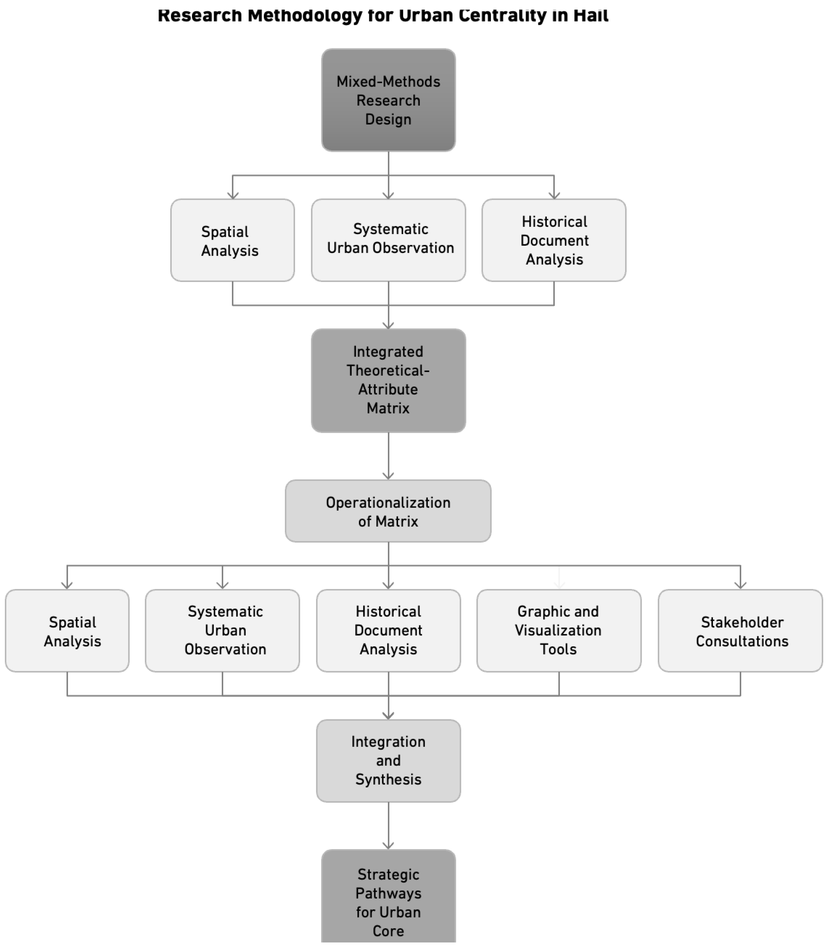
This study adopts a mixed-methods exploratory research design that integrates quantitative spatial analysis, systematic urban observation, and historical document analysis to investigate the dynamics of urban centrality in Hail, Saudi Arabia. This design responds to the multi-dimensional nature of centrality, requiring both measurable spatial data and contextual, visual, and historical insights to capture its evolving character. Through the integration of spatial mapping, network analysis, empirical observations, and archival documentation, this study endeavors to develop a holistic comprehension of the interplay among spatial, economic, social, governance, and technological determinants that influence the urban core of Hail (
Figure 1).
While the theoretical framework reflects a comprehensive view of urban centrality, including attributes applicable at both intra-city and regional levels, the application of these attributes is scale-sensitive. In this study, emphasis is placed on how each attribute manifests specifically in the central urban core of Hail. For instance, attributes like ‘Mixed Use’ are interpreted through the lens of commercial–residential integration within traditional districts, while ‘Innovation and Technology’ is assessed through basic infrastructure upgrades and digital presence in public spaces, rather than advanced smart city systems typical of metropolitan cores.
The integrated theoretical-attribute matrix, developed from established urban theories, serves as the conceptual and analytical backbone of the methodology. This matrix ensures that the study systematically addresses all key dimensions of urban centrality, including economic activity, accessibility, cultural vibrancy, density, governance presence, architectural identity, public spaces, and technological innovation. Each attribute is explicitly connected to a theoretical dimension, providing a structured foundation for comprehensive analysis and interpretation.
Operationalization of the Integrated Matrix:
The matrix is applied through the following methodological components:
Spatial Analysis:
Spatial mapping and quantitative assessment techniques are used to analyze economic clustering, connectivity, density, and land-use distribution, providing a data-driven understanding of the physical and functional structure of urban centralities.
Systematic Urban Observation:
Field observations are conducted using direct observations, photographic documentation with cameras, and behavioral mapping tools to record pedestrian flows, social activities, and public space usage. These observations are systematically analyzed using a scoring system (ranging from 1 to 10) based on predefined evaluation criteria covering economic activity, accessibility, cultural significance, urban density, governance visibility, architectural character, public space quality, and technological presence. Each score is justified with qualitative notes based on the field assessments. The scoring system, ranging from 1 (very poor) to 10 (excellent), was developed using a multi-criteria evaluation framework adapted from established urban assessment studies [
51,
52,
53]. Each attribute was evaluated based on a combination of observational data, photographic documentation, and stakeholder feedback, supported by a standardized rubric to minimize subjectivity. For example, “Accessibility and Connectivity” considered criteria such as number of entry points, pedestrian permeability, signage clarity, and transport integration. “Public Spaces and Amenities” included factors like seating availability, shade, cleanliness, and spatial openness. Each attribute had a minimum of four sub-indicators, which were scored independently and averaged to produce the final score. A fieldwork team of three researchers independently assigned scores and then reached consensus through a structured interrater discussion process.
As a result, to avoid conceptual ambiguity, this study carefully distinguishes between overlapping attribute pairs. “Cultural and Social Significance” refers to the presence of cultural events, active public life, and symbolic meanings embedded in places—reflecting how people use and identify with spaces. In contrast, “Architectural and Historical Significance” pertains to the age, preservation, visual distinctiveness, and heritage value of buildings and structures. Similarly, “Density and Mixed Use” is defined by the spatial patterning of land use types (e.g., integration of residential, commercial, and service functions within walkable proximities), whereas “Public Spaces and Amenities” assesses the physical availability, accessibility, and quality of shared outdoor areas like plazas, sidewalks, and green pockets. This conceptual clarity underpins the scoring process and ensures each attribute captures a distinct facet of urban centrality.
Historical Document Analysis:
Archival maps, urban plans, and historical photographs are examined to understand the temporal evolution of Hail’s centrality, providing a historical dimension that complements the current spatial and observational analysis.
Graphic and Visualization Tools:
Infographics, diagrams, and spatial visualizations are developed to support deeper interpretation and communication of centrality dynamics, ensuring the findings are accessible and actionable.
Stakeholder Consultations (if applicable):
Interviews with urban planners, municipal officials, and community representatives are conducted to evaluate governance structures, institutional roles, and the impact of technological initiatives on urban centrality.
Integration and Synthesis:
Findings from all methods are synthesized, linking empirical data, historical context, and observational insights back to the theoretical framework. This ensures that conclusions and recommendations are scientifically grounded and practically applicable.
By applying this multi-dimensional, theory-informed, and tool-supported methodology, this study aims to diagnose the current performance of Hail’s urban core, understand its historical development, and propose strategic pathways to strengthen its resilience, livability, and sustainability. This comprehensive approach enhances the scientific rigor of the research while maximizing its practical relevance for urban planners, policymakers, and stakeholders seeking to optimize urban centrality in medium-sized cities like Hail.
4. Results
4.1. Constituting Urban Centrality in Hail
This section focuses on the spatial and functional characteristics of Hail’s traditional urban core, where not all centrality attributes—especially those with regional or high-tech implications—are fully present. Observations therefore emphasize historically rooted attributes such as economic activity, governance, and cultural significance. It examines how urban centrality in Hail has emerged, evolved, and is currently expressed through spatial, functional, and social dynamics. Building on the integrated theoretical-attribute matrix, the analysis focuses on identifying the economic activities, accessibility patterns, public spaces, cultural landmarks, and institutional functions that define Hail’s urban core. Using spatial analysis, systematic observation, and historical references, this section investigates how these elements interact to shape the city’s centrality over time. The purpose is to establish a baseline assessment of Hail’s central areas by mapping their current conditions and evaluating their performance across the identified attributes. This analysis positions Hail’s urban core not only as a historical and administrative center but also as a dynamic space whose evolution directly influences the city’s resilience, vibrancy, and future development potential.
4.1.1. Historical Development
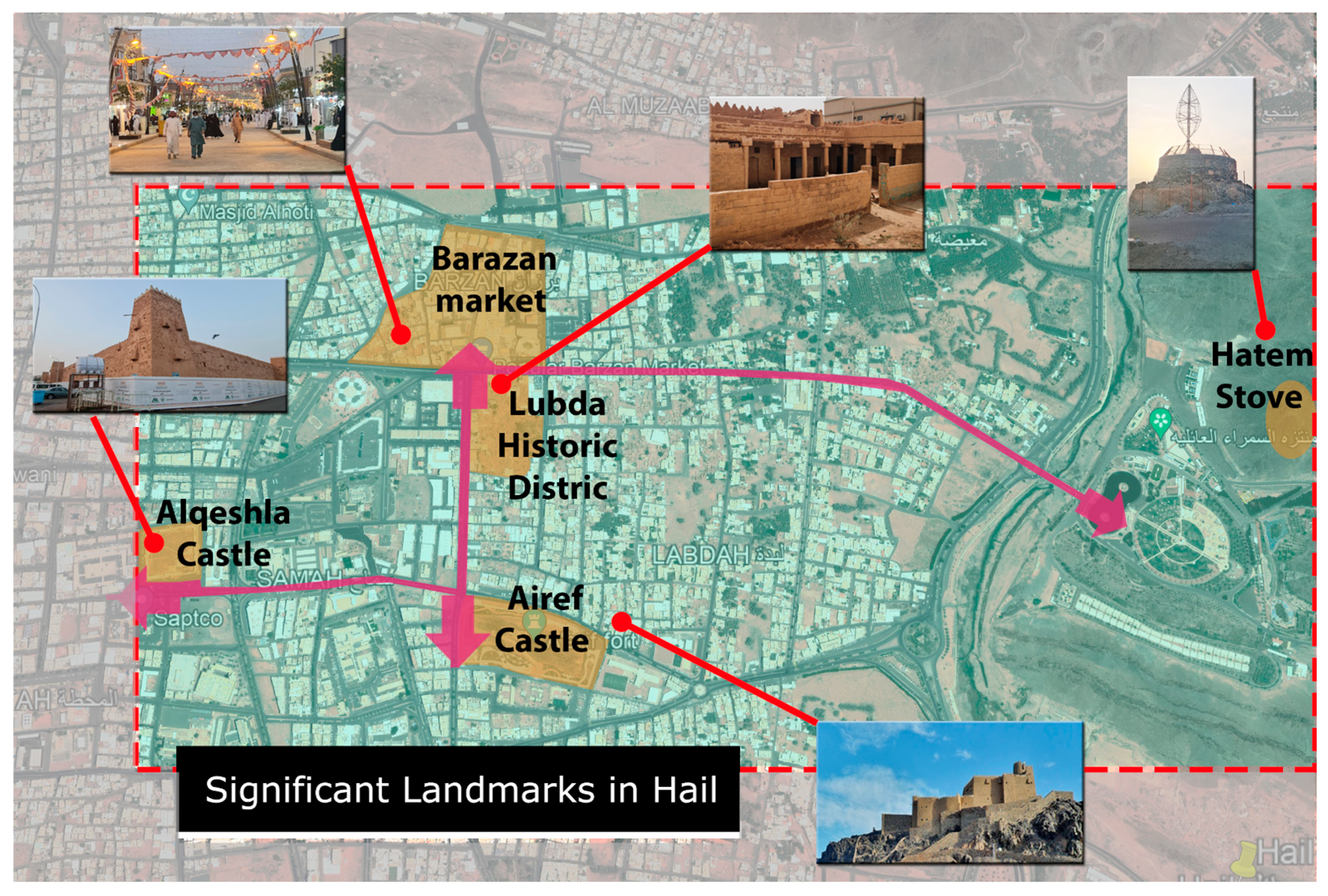
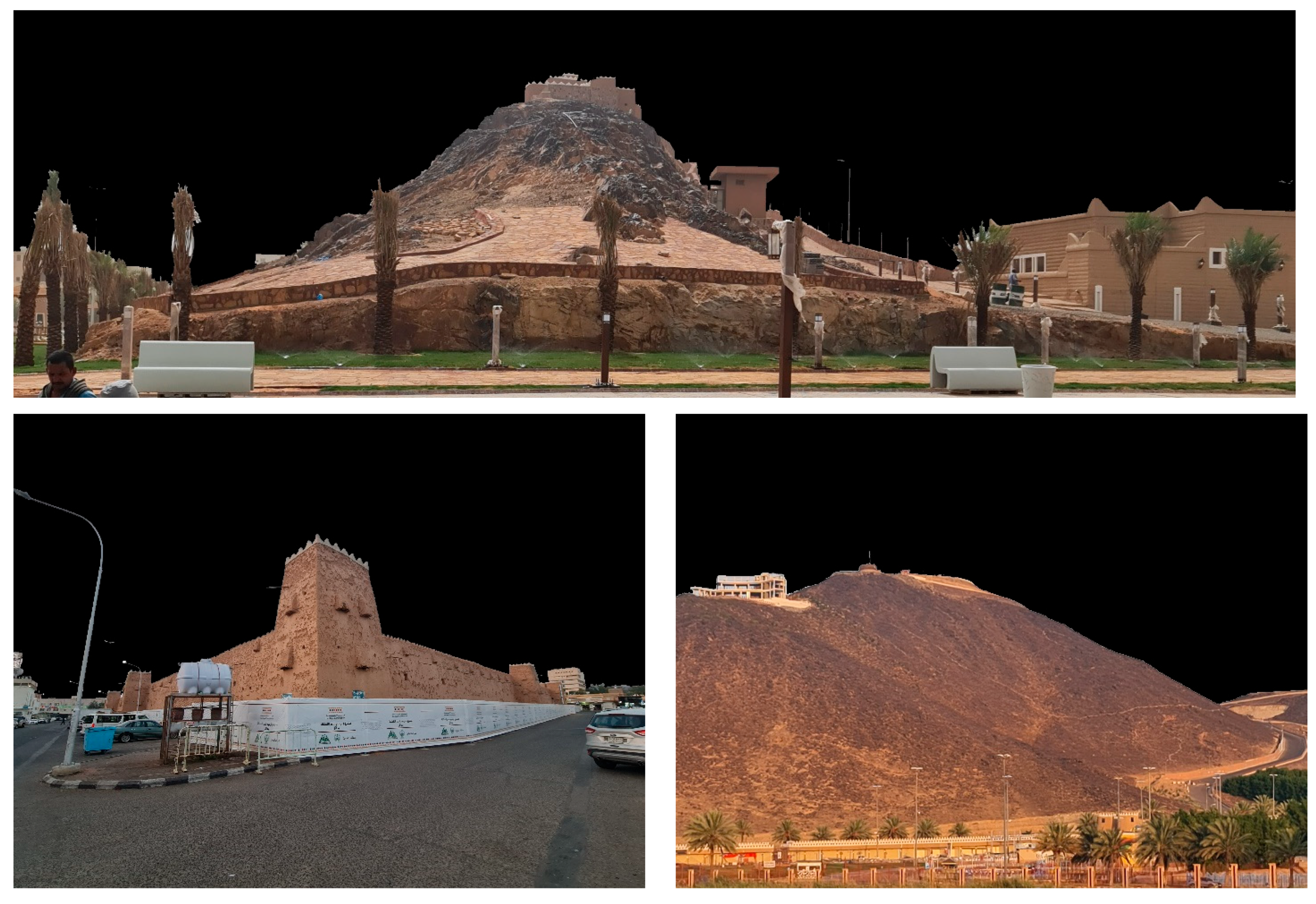
Hail City is a renowned oasis city with abundant water wells, serving as a crucial stopover for ancient caravan trade routes and pilgrims [
54]. Known for the generosity of its people, the city is home to the famous poet and king Hatem al-Tai. Situated strategically at the intersection of ancient trade routes, it is a significant agricultural hub with numerous farms and gardens, boasting a history tracing back to pre-Islamic eras [
55]. Due to its historical and cultural importance, Hail City is a favored destination for tourists. The city is distinguished by its three grand castles and reputation for fertile lands, particularly as a major date producer, evolving into an essential Islamic education center [
54]. Among its notable landmarks is the A’arif Fort, a 200-year-old mud castle perched on a hill overlooking the city, offering a scenic view and attracting many visitors. Another prominent structure is the sprawling Barzan Palace, covering over 300,000 square meters, initiated in 1808 and finalized under the rule of Talal ibn Abdullah, the second Rashidi emir. Comprising three levels with reception areas, gardens, kitchens, and accommodations for the Royal Family and dignitaries, the palace showcases remarkable architectural grandeur. The palace was demolished, leaving structures like Barzan Towers isolated. These towers and wall ruins are important historical sites in Hail’s Barzan district, reflecting past civilizations (
Figure 2).
This historical layering exemplifies the attribute of ‘Architectural and Historical Significance’ as defined in
Table 1, where urban identity is shaped through the preservation of heritage forms. These sites—particularly Barzan Palace and the A’arif Fort—also directly inform the high evaluation score (9/10) assigned to this attribute in
Table 2, underlining their centrality in Hail’s cultural and architectural memory.
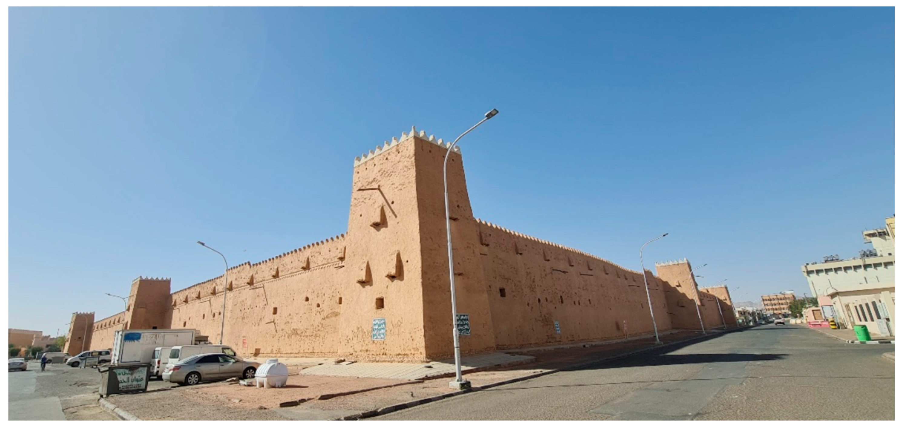
Lastly, the Qishlah Fortress stands as the third key fort in Hail City, erected in 1
941 as the residence of the Hail emirs. Enclosed by towering walls, the rectangular fortress features four courtyards, a mosque, a prison, and jail facilities (
Figure 3).
The Barzan Market stands out as a premier destination for purchasing a diverse array of merchandise. The market is renowned for its extensive range of garments, scents, handcrafted items, spices, dried fruits, and footwear, making it a preferred destination for extravagant shopping sprees. Positioned in the heart of the city, it offers a convenient shopping experience. Serving as a comprehensive retail hub catering to all traditional requirements, the Barzan Market has emerged as a leading marketplace in the area. It serves as the economic focal point of the region and attracts numerous traders. Situated centrally in Hail’s historic quarter, the market has become a top draw for tourists, making it one of the city’s most popular attractions. The combination of its strategic location and historical significance contributes to its perennially overcrowded status. The preservation and revitalization of these structures contribute not only to tourism and cultural continuity but also anchor the urban core in terms of governance presence and economic vibrancy. These dynamics correlate with the ‘Governance and Institutional Presence’ and ‘Economic Activity’ dimensions of
Table 1 and are reflected in
Table 2, where these attributes scored 7 and 8, respectively, underscoring their observed impact on Hail’s urban centrality. The Barzan Market site has special symbolism due to its proximity to the historic remnant Barzan Palace. The market was named ‘Barzan’ because it was the tallest complex.
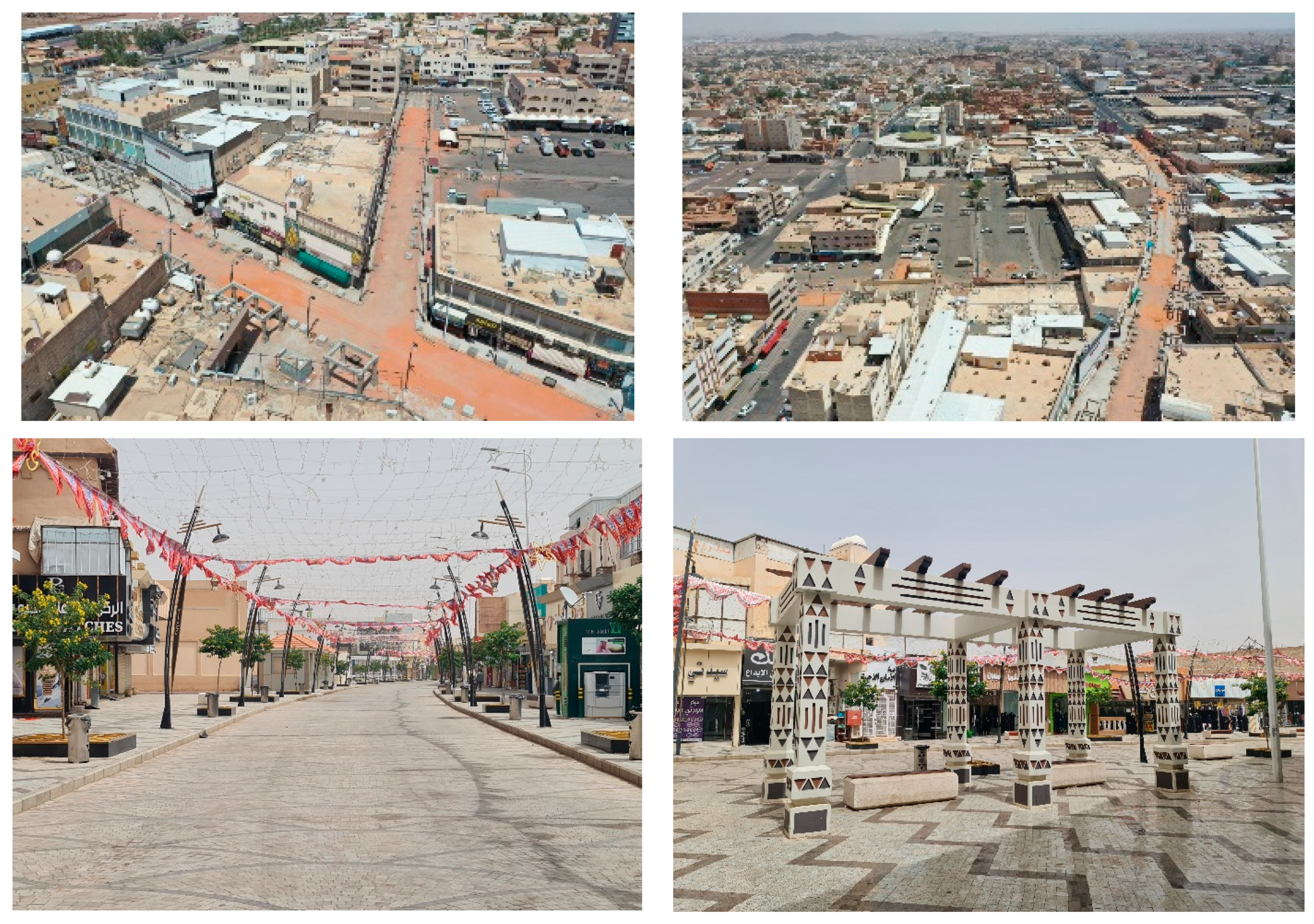
The renovation of the Barzan traditional market aimed to enhance the main tourist attraction by addressing issues like accessibility and vehicle use. Hail Municipality intervened in late 2019 to transform the market into a pedestrian-only space to increase visits and improve the overall experience. Renovating Barzan Market is crucial for the city’s growth and economy, attracting new businesses and tourists. It is expected to create jobs and boost the city’s population, benefiting cultural tourism in the future. This redevelopment marks a significant advancement for Hail City. The project’s goal is to enhance the visual appeal of Barzan Market, benefiting the social and economic aspects of the city [
54].
Enhancements encompass amenities, services, and infrastructure to deliver an enhanced shopping experience for both merchants and patrons. The project’s value of around twelve million Saudi Riyal signifies its importance and involves policy changes to convert the area into a pedestrian zone with high-quality venues. The project involves paving Market Avenue with granite, developing areas nearby, redeveloping entrance gates, and investing in kiosks and facilities. Barzan Market’s rehabilitation is 95% completed, promising a safer and more vibrant place. A future plan aims to connect Barzan with the new city center (
Figure 4).
4.1.2. Economic and Social Activities
The prevailing economic and social undertakings within Hail’s city core are pivotal in establishing its urban centrality. The locality prospers due to a blend of commercial, recreational, and cultural pursuits that allure denizens from both the city and its environs. Markets, shopping precincts, and commercial hubs act as economic drivers, while parks, cultural establishments, and event arenas enhance the communal milieu. These functions closely correspond to the ‘Economic Activity’ and ‘Cultural and Social Significance’ attributes defined in
Table 1, which emphasize the central role of commercial clustering and socio-cultural vibrancy in shaping urban centrality. Thus, activities not only stimulate economic progress but also bolster social unity and cultural expression, rendering the city core a lively nucleus of communal interaction. This is supported by the high scores assigned to these attributes in
Table 2—8 out of 10 for Economic Activity and 9 out of 10 for Cultural and Social Significance—highlighting their tangible contributions to Hail’s urban centrality and everyday vibrancy (
Figure 5).
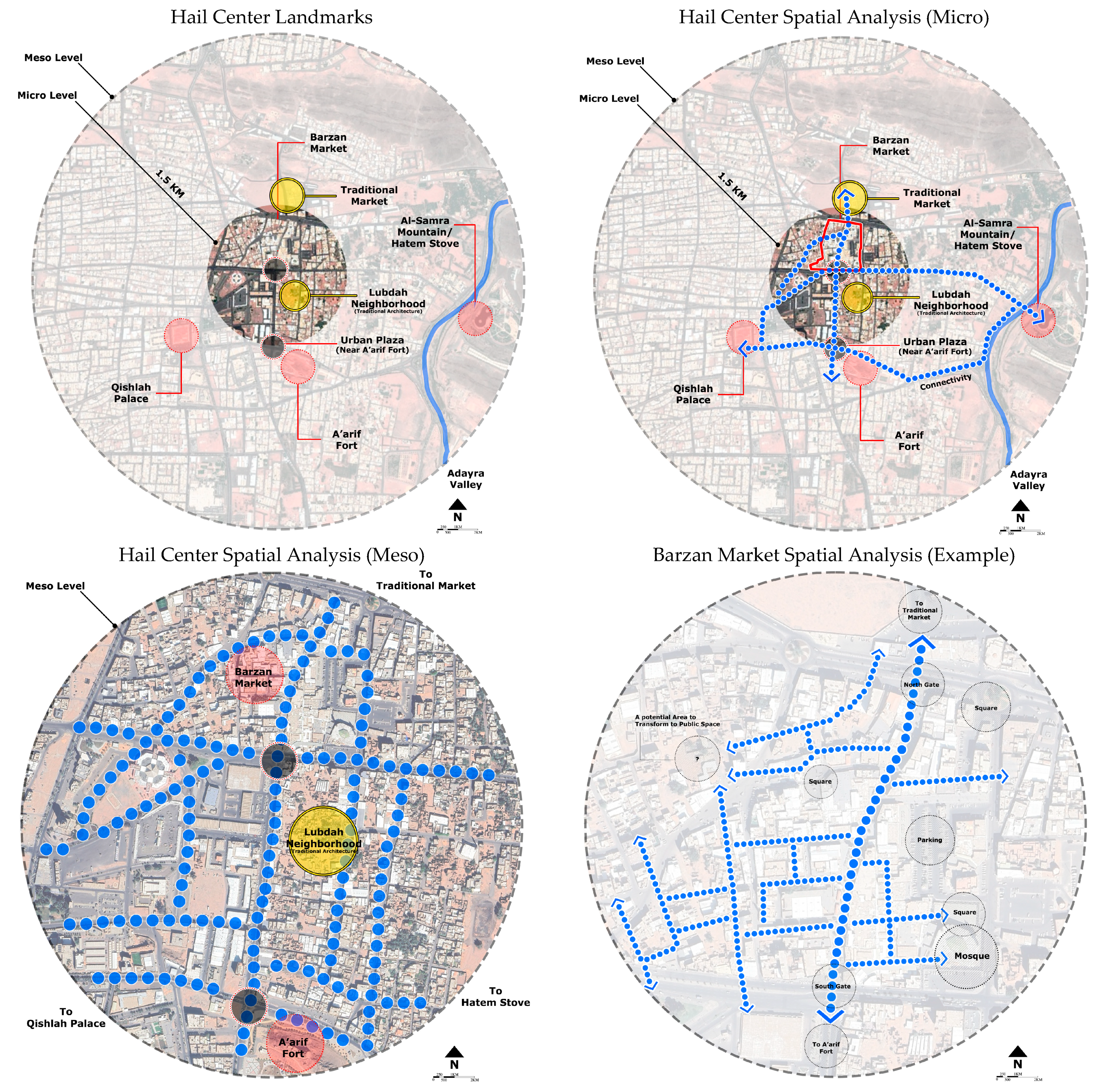
4.1.3. Spatial Examination
The spatial analysis of Hail’s city center reveals a dense and compact urban structure, characterized by a continuous built fabric with minimal open spaces. In this study, spatial analysis refers to the application of spatial mapping techniques and visual interpretation tools, including land-use pattern mapping, pedestrian movement tracking, and nodal accessibility assessments. Site observation overlays were used to trace street connectivity, identify active and underutilized zones, and evaluate the density and alignment of commercial and civic anchors. This multi-scalar approach allowed for a simulated structured assessment of spatial hierarchy, movement flows, and spatial integration within the central urban fabric. This configuration creates a pedestrian-oriented environment where connectivity and movement appear to have been prioritized, as observed during on-site assessments. The main axis linking the eastern and western entrances of the market functions as the primary pedestrian corridor, concentrating the highest levels of foot traffic. Merchants along this route reported a visible increase in visitors, suggesting that recent efforts to enhance pedestrian accessibility have positively impacted commercial activity (
Figure 6).
However, while the compact layout promotes movement along certain key pathways, it also presents challenges. The market’s dense spatial organization, defined by tightly packed buildings and narrow corridors, limits the availability of larger, accessible open spaces. The few existing spaces, such as small squares near mosques or intersections, serve as secondary gathering points but are insufficient in creating a balanced public realm. Field observations further identified several disconnects in pedestrian circulation, with many pathways leading to underutilized areas, including parking lots or dead-end spaces that do not support active commercial or social functions. Feedback from shopkeepers confirmed that these inefficient connections reduce customer flow to parts of the market, especially in areas located away from the main pedestrian corridor (
Figure 7). This highlights a spatial imbalance where certain sections thrive while others remain marginalized due to limited connectivity and poor spatial integration.
An analysis of the spatial structure of Hail’s downtown underscores the strategic role of physical spaces and infrastructure in shaping its centrality. Prominent landmarks, including heritage buildings, government offices, and religious sites, act as key anchors that organize and activate urban life around them. Supporting these focal points, the transportation networks, public services, and communication systems enhance the area’s accessibility, connectivity, and functionality, facilitating not only the movement of people but also enabling social interaction, recreation, and public gatherings. Together, these elements reinforce the practical value and experiential appeal of the city center, positioning it as a critical urban node where civic, cultural, and economic activities converge.
4.1.4. Contribution to Hail’s Identity and Functionality
The attributes of urban centrality in Hail play a defining role in shaping the city’s identity, functionality, and urban character. Integrating historical, economic, social, and spatial dimensions, this centrality has created a dynamic urban core that not only reflects Hail’s rich cultural and historical legacy but also serves as a driving force for ongoing economic vitality and community life. This multifaceted role enhances local identity, supports social interaction, and fosters inclusive community engagement, contributing to a vibrant environment that continues to evolve in response to the city’s emerging needs and aspirations.
Hail’s urban centrality is deeply rooted in its heritage, reflected in its historical landmarks, traditional urban forms, and cultural practices, which continue to anchor the city’s collective memory. These historical elements are integrated with contemporary urban development strategies aimed at promoting economic diversification, spatial efficiency, and urban livability. The city’s spatial dynamics—shaped by strategic planning, transportation infrastructure, and land-use management—ensure that the central area remains accessible, navigable, and economically active, reinforcing its position as the primary urban nucleus.
Moreover, the evolution of Hail’s centrality mirrors broader urban, economic, and social transformation trends. As the urban environment proliferates, its core district persistently adjusts to emerging opportunities and obstacles, thereby maintaining its significance as a focal point for economic activity, cultural engagement, and community life. Ongoing efforts to enhance centrality through revitalization projects, cultural programming, and economic development initiatives are critical to maintaining Hail’s role as a thriving and competitive urban center within the region. These initiatives not only fortify the urban nucleus but also enhance the city’s enduring resilience and sustainability (
Figure 7).
Urban centrality in Hail reflects the city’s evolution over time, capturing the interplay between its historical legacy, economic vitality, cultural identity, and social dynamism. It serves as both a symbol of Hail’s past and a driver of its future, advancing urban development while preserving a strong connection to the city’s heritage. Recognizing and understanding this centrality is essential to appreciating Hail’s urban character and its pivotal role in shaping the broader socio-economic and cultural dynamics of the region. Viewed through this lens, Hail reveals itself not merely as a physical settlement but as a dynamic urban organism, continually adapting, progressing, and inspiring. The following assessment provides a structured evaluation of this centrality (see
Table 2 and
Figure 8).
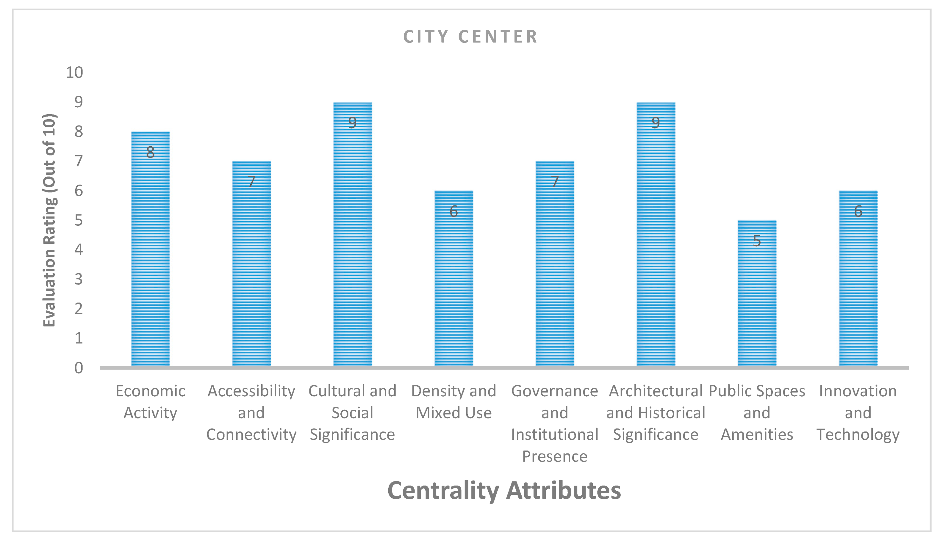
This structured evaluation is based on an attribute-based scoring system developed in alignment with the theoretical dimensions outlined in
Table 1. Each attribute—such as economic activity, accessibility, or architectural significance—was assessed using predefined criteria drawn from observational fieldwork, photographic documentation, and stakeholder insights. Each score (on a scale of 1 to 10) represents an average of four sub-indicators specific to that attribute. For instance, ‘Public Spaces and Amenities’ was evaluated using sub-criteria such as seating availability, spatial openness, greenery, and pedestrian comfort. A team of three trained observers independently scored each sub-indicator based on field visits, then reached a consensus score through interrater validation. These results, presented in
Table 2, reflect a triangulated and standardized assessment process that minimizes subjectivity while emphasizing on-the-ground evidence. Whereas “Cultural and Social Significance” refers to community engagement and symbolic meaning, “Architectural and Historical Significance” pertains to the physical built heritage. “Density and Mixed Use” evaluates land-use integration and building intensity, while “Public Spaces and Amenities” focuses on the availability and design quality of open public areas.
4.2. Hail in the Face of Change: Urban Dynamic Factors
Hail’s urban landscape is subject to a variety of change factors, including economic diversification, population growth, technological advancements, and cultural shifts [
56,
57,
58]. This section examines how these factors influence the dynamics of urban centrality, affecting everything from land use patterns to social interactions and economic activities [
59]. The resilience and adaptability of Hail’s urban center in responding to these changes are critical themes explored in this part of the study [
60], drawing on the definitions outlined in the conceptual framework (
Section 2.1) to assess how Hail’s urban core maintains functionality while adjusting to evolving demographic, economic, and cultural pressures.
4.2.1. Economic Diversification
The transformation of Hail’s urban landscape is notably influenced by the dual forces of economic diversification and the development of contemporary commercial zones [
61]. The strategic expansion of the city’s economy into new commercial, industrial, and service-oriented areas has not only attracted investments but also revamped the urban environment, introducing a mix of activities and spaces that redefine the city’s centrality [
59]. This shift is evident in the establishment of mixed-use complexes, technological hubs, and cultural districts, enriching the urban fabric with diverse economic opportunities.
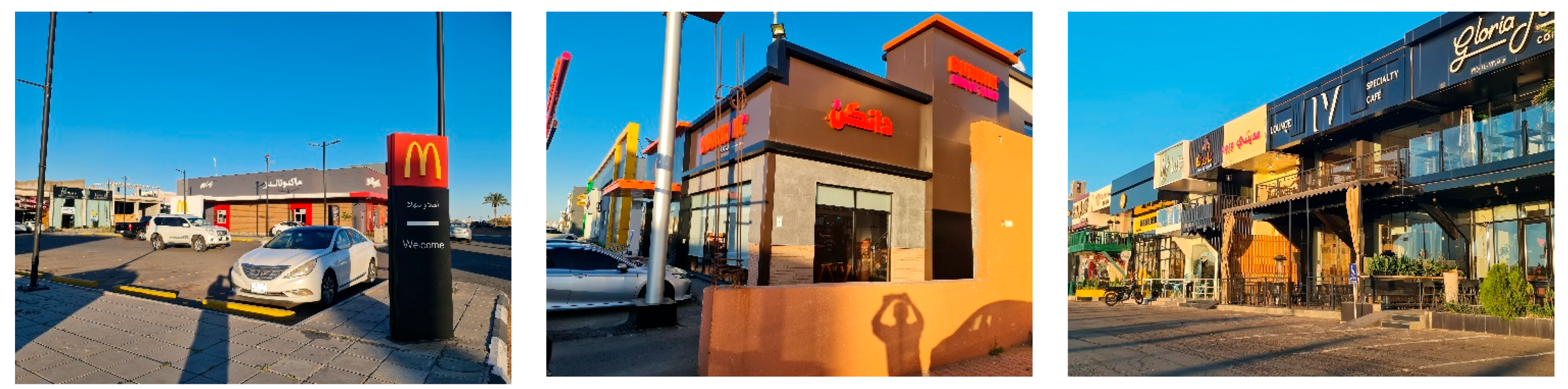
The contemporary establishment of commercial hubs on opposite ends of the city, namely the north and south, is significantly influential in defining its urban identity. Key landmarks such as the Grand Mall, coupled with an array of fast-food restaurants like McDonald’s, Herfy, and KFC, alongside coffee chains such as Dunkin and Starbucks, add to the city’s gastronomic appeal [
61]. The enhancement of the retail landscape with service-oriented businesses, including healthcare clinics and fashion boutiques, further contributes to the emergence of lively, central districts in Hail’s growing neighborhoods. Together, these elements signify a measurable shift toward a more vibrant and diverse urban center, propelled by economic diversification and the spatial expansion of commercial activities—an urban transformation process commonly observed in second-tier cities undergoing economic transition (e.g., in Russia [
62], Australia [
63]) (
Figure 9).
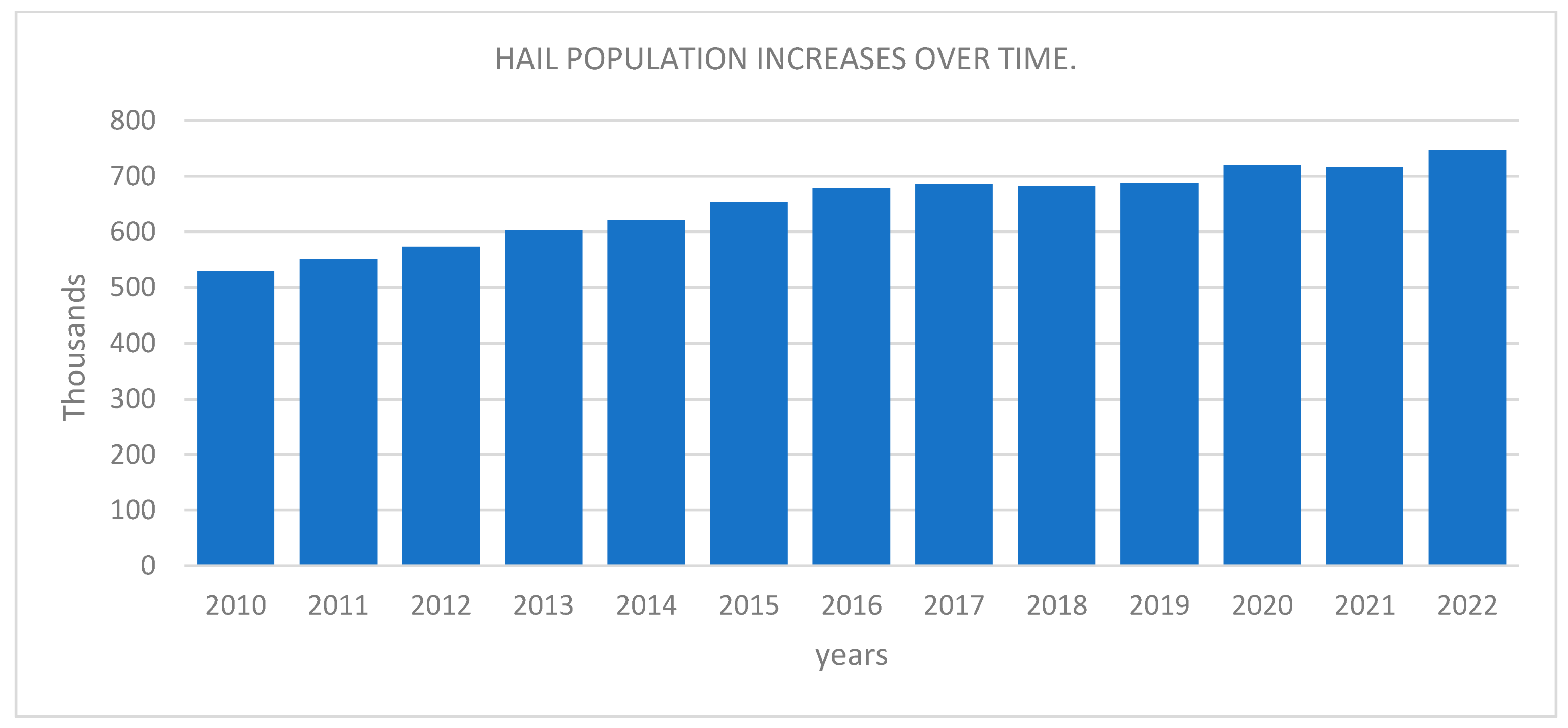
4.2.2. Population Growth
The population growth of Hail, illustrated by the bar chart covering the period from 2010 to 2022, illustrates a substantial and consistent rise, almost doubling from slightly above 400,000 to nearly 800,000. This persistent growth trend carries profound implications for the urban landscape of the city, leading to an increase in the requirement for housing, facilities, and infrastructure. With the enlargement of the population, the tension on current urban areas mounts, fostering the growth of new residential and commercial zones and a more intensive utilization of public spaces. This process of densification in the central areas of the city and the expansion of its peripheries necessitates the implementation of innovative urban planning and development approaches to sustain a coherent urban nucleus amidst a shifting demographic terrain. The graph not only denotes a significant population surge in Hail—nearly doubling from around 400,000 in 2010 to almost 800,000 in 2022—but also signals a corresponding rise in economic dynamism and spatial development pressures. For comparison, while Saudi Arabia’s national population grew by approximately 31% during the same period (from 27 million in 2010 to about 35.4 million in 2022) [
22], Hail’s growth exceeded 90%, indicating a more accelerated urban expansion trajectory than national averages. In contrast, Riyadh grew by approximately 55% in that period, reinforcing the case that Hail’s population increase reflects pressing and localized planning demands.
Figure 10 illustrates a significant demographic surge in Hail. While demographic growth does not automatically imply economic dynamism, it often correlates with increased demand for housing, infrastructure, and services. In Hail’s case, this trend has coincided with expanded commercial development and municipal investments in urban renewal projects (e.g., Barzan Market rehabilitation), which suggest that population growth is part of a broader urban transformation. However, it is acknowledged that further economic indicators would be required to confirm the depth and inclusiveness of this growth.
4.2.3. Technological Advancements
Technological progressions are transforming the fundamental structure of urban life in Hail, modifying various aspects from transportation networks to communication systems. The incorporation of intelligent technologies is restructuring urban infrastructure, resulting in increased effectiveness and interconnectedness, subsequently impacting land utilization and mobility trends. The emergence of digital platforms has ushered in novel modes of social engagement and economic transactions, fostering urban environments that are more adaptable and lively [
57]. With technology pervading diverse facets of urban life, it reshapes the importance of urban spaces, transforming how individuals engage with the city and with one another.
A prevalent scene in Hail presently involves the congregation of individuals during the inauguration of a new coffee shop, shopping center, or event concentrations of human activity that endure for extended periods in locations that previously experienced minimal to no such congregations. This occurrence underscores the influence of technology on urban social structures, shaping the way people establish connections within their urban landscapes.
4.2.4. Cultural Shifts
The cultural landscape of Saudi Arabia is undergoing a significant overhaul, profoundly influencing the urban core of cities like Hail. This transformation is evident in the evolving lifestyles, consumption patterns, and social norms that dictate the demand for and use of urban spaces and amenities. At the heart of this transformation is Vision 2030 [
57], a strategic framework that has catalyzed increased openness, inclusivity, and human rights awareness in the Kingdom. This cultural shift is mirrored in the integration of women into the workforce, more diverse expressions of religion, and reforms in laws and policies to support these changes.
Technological advancements have further fueled cultural evolution, particularly among Saudi youth, who are increasingly exploring cultural identities and engaging politically through the internet and smartphones. This has brought about what can be termed the third cultural revolution, marked by Western influences in areas like cuisine, music, and fashion. Simultaneously, Saudi Arabia’s global market integration, through special economic zones and ambitious infrastructure projects, reflects its socio-economic and technological progress.
In reaction to these cultural changes, there is a rethinking of public spaces. Women are more visible in society, seen in their changing attire and participation in public life, including parks, eateries, and malls. The cultural renaissance is also visible in the burgeoning of art galleries and museums that bridge traditional and contemporary arts, alongside cultural events that allow citizens to revel in their heritage. As Saudi society melds traditional values with new paradigms and technologies, there is an imperative for innovative design and diversification of public spaces that align with the nation’s forward-looking vision. This is resulting in an active transformation of public areas into inclusive environments that cater to a variety of interests and reflect the country’s evolving cultural ethos.
4.2.5. Resilience and Adaptability
Hail’s urban heart demonstrates remarkable resilience and adaptability, key qualities that maintain its vibrancy and central importance amid ongoing change. In this context, resilience refers to Hail’s capacity to maintain the essential functions of its urban core—economic vitality, social cohesion, and institutional continuity—despite pressures from rapid urbanization, demographic shifts, and cultural change. Adaptability, on the other hand, is understood as the city’s ability to proactively adjust its spatial configurations, land-use functions, and urban services in response to evolving needs. These two qualities are central to the study’s objective of evaluating how urban centrality evolves over time: resilience explains how the core preserves continuity, while adaptability reveals its capacity to reconfigure and respond dynamically. Together, they form a diagnostic lens for assessing whether the city’s centrality is robust, inclusive, and future-ready. Urban planning and development strategies that prioritize flexibility, creativity, and inclusiveness are essential for navigating the complexities of such change. By fostering an environment that can pivot in response to shifts in the economy, demographics, technology, and culture, Hail can ensure its urban core remains an active and integral part of the city’s landscape.
The city’s growth pattern unfolds in a linear progression along Mount Aja, extending north to south, with the historical center near Mount Samra standing as a testament to its origins. This pattern is captured in
Figure 11, which outlines Hail’s urban plan, detailing the historic center as well as the new residential areas proliferating in both directions.
In recent decades, the establishment of a university and a growing business environment have catalyzed demographic shifts, drawing people from rural locales predominantly to the city’s northern regions. Simultaneously, there is a noticeable migration of the central area’s inhabitants toward the freshly developed neighborhoods in the south of Hail. These movements underscore the dynamic nature of the city’s urban sprawl, reflecting a blend of historical continuity and modern expansion.
In essence, the urban dynamic elements encompassing economic diversification, population expansion, technological progress, and cultural transformations exert a substantial impact on the centrality and operational efficiency of Hail’s urban setting. The crucial aspect lies in the city’s capacity to adjust and react to these elements, ensuring the preservation of its liveliness and significance amidst a constantly evolving global context.
4.3. Movement of the Urban Center
The dynamism of urban centers is evident in their capacity to shift and evolve over time. This section investigates the contemporary movements of Hail’s urban center, after we have identified the drivers behind these shifts and their implications for urban planning and development. The analysis focuses on the spatial and functional transitions of centrality within the city, offering insights into the patterns of urban expansion and contraction.
Historically, Hail’s urban center has undergone changes shaped by socio-economic progress, political transformations, and natural occurrences. Initially, centrality may have been determined by key trade routes, water sources, or political hubs, causing the urban center to naturally gravitate towards these focal points. As time passed, with the expansion of trade, advancements in technology, and shifts in political landscapes, the location and significance of the urban center adjusted accordingly. Historical movements of the urban center demonstrate the city’s reaction to external pressures and opportunities, revealing a trend of adaptation and transformation inherent in urban development.
4.3.1. The Gravity of Growth: Centrality in the Metropolitan Spectrum
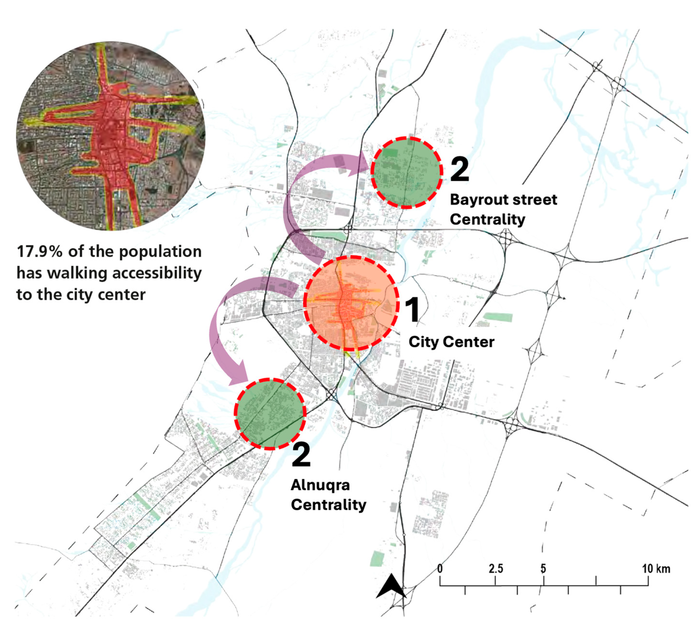
In more recent times, the displacement of Hail’s urban center is increasingly influenced by contemporary development endeavors, economic diversification initiatives, and demographic changes. Modern shifts are often intentional, guided by urban planning strategies aimed at fostering sustainable development, enhancing connectivity, and improving urban living standards [
61]. These changes may involve establishing new business districts, rejuvenating historical areas, or creating green, pedestrian-friendly urban environments. The contemporary movement of the urban center underscores a strategic approach to managing urban expansion and meeting the evolving needs and preferences of the population (
Figure 12).
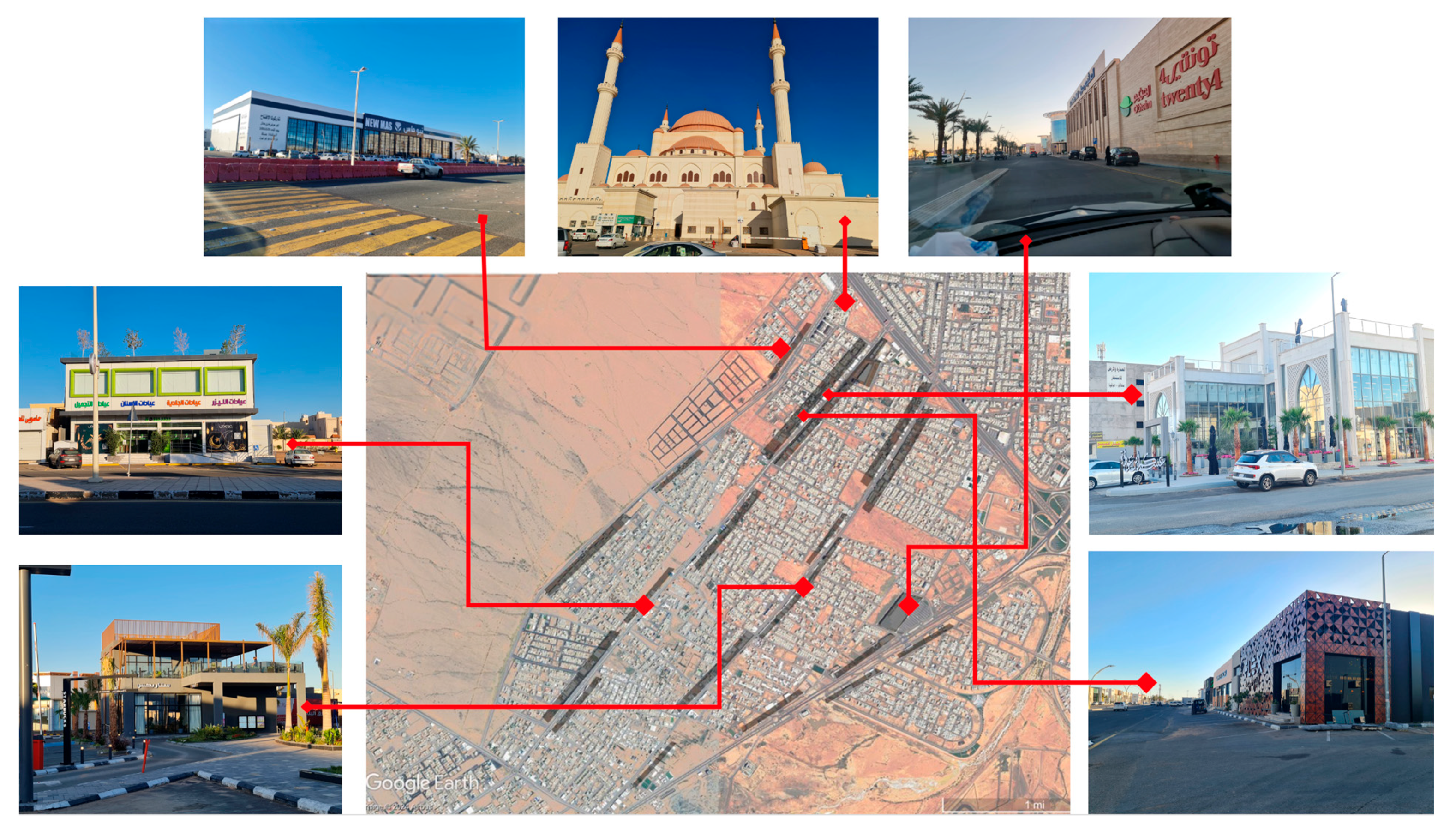
4.3.2. The Southern Centrality in Alnuqra Neighborhood
This neighborhood shines as a beacon for economic vitality and investment, distinguished by its wealth of cafés, restaurants, and standout services that dot the cityscape. It is a hub where the energy of the city’s commercial life is palpable, drawing entrepreneurs and patrons alike to its vibrant streets. Its mix of daytime banking activity and evening social buzz, driven by a high demand for its diverse dining and café culture, showcases a dynamic community that caters to a broad spectrum of needs and preferences (
Figure 13).
Connectivity and cultural richness form the backbone of this neighborhood. Its strategic location, directly accessible from the city’s ring road through Al-Arifi Street, Al-Arba’oun Street, and Al-Rajhi Street, ensures seamless integration with the urban fabric. Beyond its physical connections, the neighborhood stands as a cultural epicenter, home to the iconic Al-Rajhi Mosque and serving as a representation of the city’s indigenous middle-class population. The architectural marvels, including government buildings and modern commercial establishments, speak to a history of thoughtful development and an eye towards accommodating both heritage and progress.
Nevertheless, the expansion of the region has encountered a myriad of obstacles. While it excels in offering modern conveniences and a lively atmosphere, it falls short in providing adequate public spaces for pedestrians, impacting overall movement safety. Additionally, while equipped with some surveillance technology for traffic and speed monitoring, there is a pressing need for advanced technological integration to enhance security measures and improve user experience. Addressing these concerns could further elevate the neighborhood’s standing as a model of urban living, blending tradition with innovation (
Table 3).
The evaluation of the southern centrality in the Alnuqra neighborhood highlights its strong economic vitality (8) and strategic connectivity (8), both of which position it as one of Hail’s most active commercial and social hubs. The area performs particularly well in terms of economic activity, benefiting from a diverse mix of services, cafés, restaurants, and banks that generate continuous vibrancy throughout the day and evening. Its direct connection to major city routes enhances accessibility and supports high visitor flow. Cultural and social significance is also notable (7), particularly through the presence of Al-Rajhi Mosque, which serves as a cultural and spiritual anchor for the local community. However, the area shows a moderate performance in density and mixed-use integration (7), with commercial activities dominating over residential functions, which could limit round-the-clock vibrancy. Governance and institutional presence (6) is visible but could be strengthened through more accessible public services and civic engagement opportunities.
Despite these strengths, the neighborhood faces noticeable challenges in public space quality (5) and technological integration (4). The pedestrian environment is limited, with a lack of sufficient seating, shaded areas, and green spaces, which reduces comfort and walkability. Architecturally, the area balances modern developments with some preserved structures, earning a moderate score (7), although it lacks distinctive icons that could further define its identity. The lowest performance is in technological innovation (4), where only basic surveillance measures are in place, falling short of smart city advancements that could enhance safety, user experience, and urban management. Overall, while Alnuqra’s southern centrality excels in commercial and social activity, it would benefit from targeted improvements in public space design, civic services, and technological infrastructure to realize its full potential as a vibrant and inclusive urban center (
Figure 14).
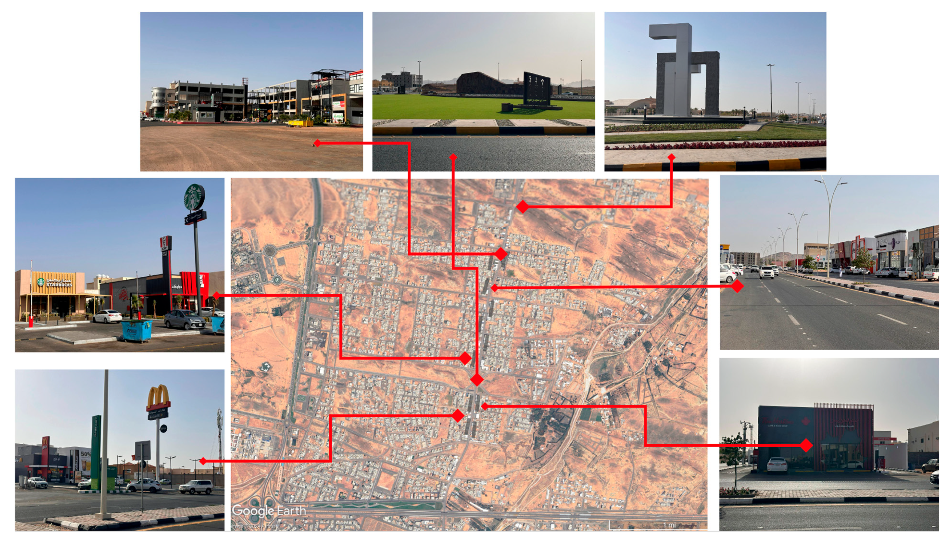
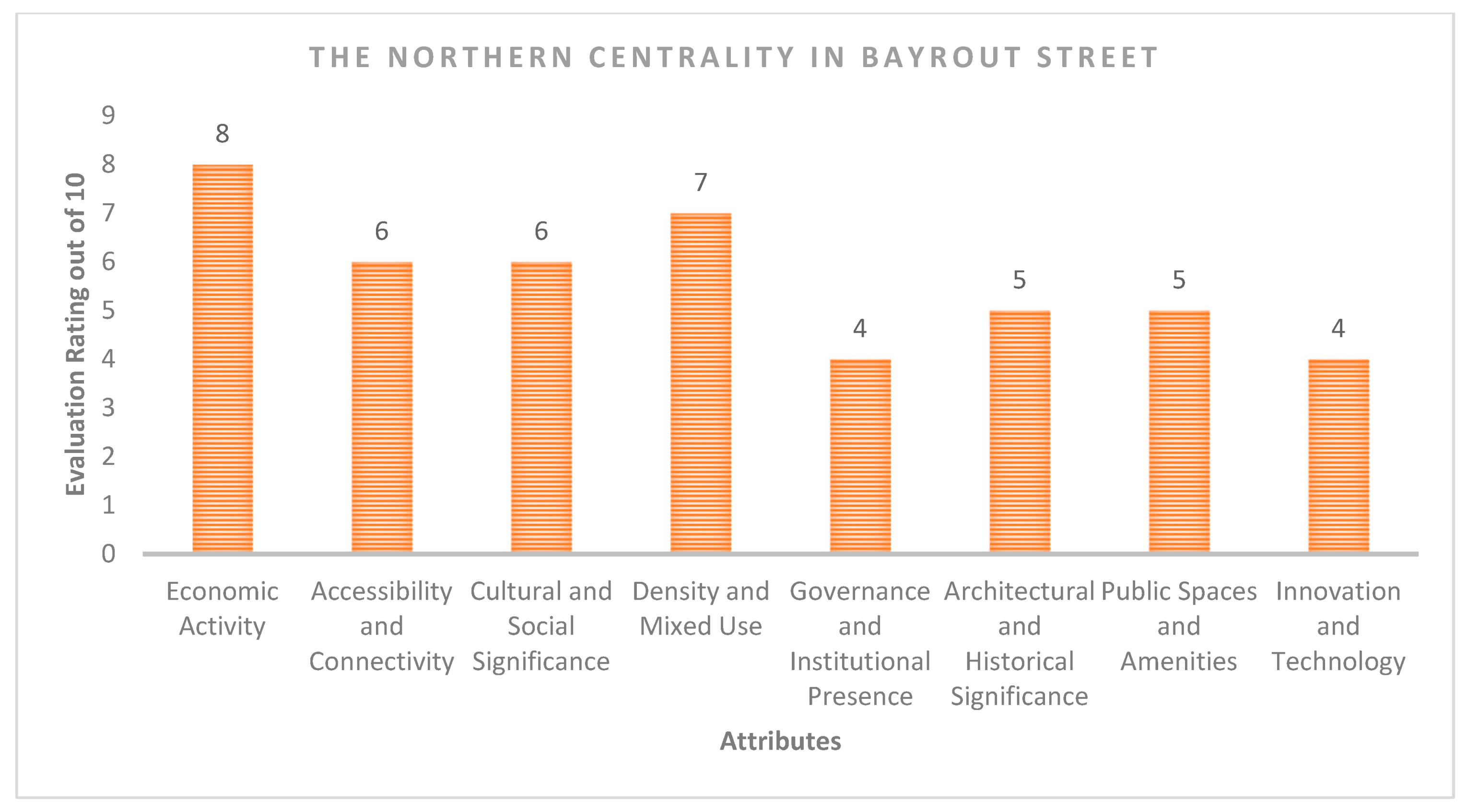
4.3.3. The Northern Centrality in Bayrout Street
This area stands out as an economic hotspot, ripe for investments and bustling with commercial activity, particularly in the northern part of the city, where cafes, restaurants, and standout services attract both locals and visitors. It has become a prime location for businesses to set up secondary operations, indicating its importance as a financial artery. Yet, its accessibility contrasts with this vibrancy; while directly connected to the city via the ring road, the primary access route through Bayrout Street is restrictive, resulting in less fluid connectivity than seen in the more accessible Naqqra neighborhood, famed for its triple main access points (
Figure 15).
The district tells a story of cultural transition, tracing the movement of Bedouin communities from the north. It is predominantly occupied by lower-income residents, and its skyline lacks the punctuation of landmark buildings that confer identity and distinction. The area’s fabric is a tapestry of various functions, maintaining a high density that is enlivened by service-related establishments and cafes. However, its civic blueprint does not highlight significant government buildings. Its contemporary face is mirrored in the banks, shopping hubs, and glass-fronted cafes that line its streets, offering a modern aesthetic but leaving a void in historical character. Public spaces here, while home to impressive cafes with chic designs, miss the mark on pedestrian-focused areas, compromising safety and accessibility. As for innovation, the neighborhood is not lacking in basic surveillance measures for traffic control, yet it stands at a threshold, requiring an infusion of cutting-edge technology to uplift its security measures and user experience. See
Table 4The northern centrality in Bayrout Street stands out as a vibrant economic node in Hail, marked by its high concentration of commercial activity (score 8). The establishments comprising cafes, restaurants, and service-based enterprises contribute to a vibrant milieu that draws the attention of both local inhabitants and tourists, thereby rendering it an appealing site for the proliferation of secondary business ventures. However, this commercial vibrancy is somewhat constrained by limited accessibility (score 6), as the area relies primarily on Bayrout Street for access, unlike other centralities that benefit from multiple entry points. Culturally, the area reflects the heritage of Bedouin communities and serves a predominantly lower-income population (score 6), but it lacks distinctive landmarks or structured cultural programming that could elevate its identity. The district’s high-density, mixed-use layout (score 7) ensures steady activity throughout the day, yet it lacks residential integration that could provide a more balanced urban rhythm beyond business hours.
Despite its commercial strengths, the area reveals weaknesses in its governance presence (score 4) and architectural identity (score 5), as it lacks prominent government institutions and heritage landmarks that typically anchor civic and cultural life. The dominance of modern, glass-fronted commercial buildings contributes to a contemporary aesthetic, but it does little to distinguish the area architecturally. Similarly, while the café culture adds social vibrancy, the quality of public spaces (score 5) is limited, with few pedestrian-friendly environments that prioritize safety and comfort. In terms of technological integration (score 4), the neighborhood operates with basic surveillance measures, but it lacks advanced smart technologies that could improve urban management and user experience. These findings suggest that while Bayrout Street’s northern centrality excels as a commercial hub, its future potential depends on enhancing accessibility, diversifying civic and cultural functions, improving pedestrian spaces, and integrating smarter urban technologies (
Figure 16).
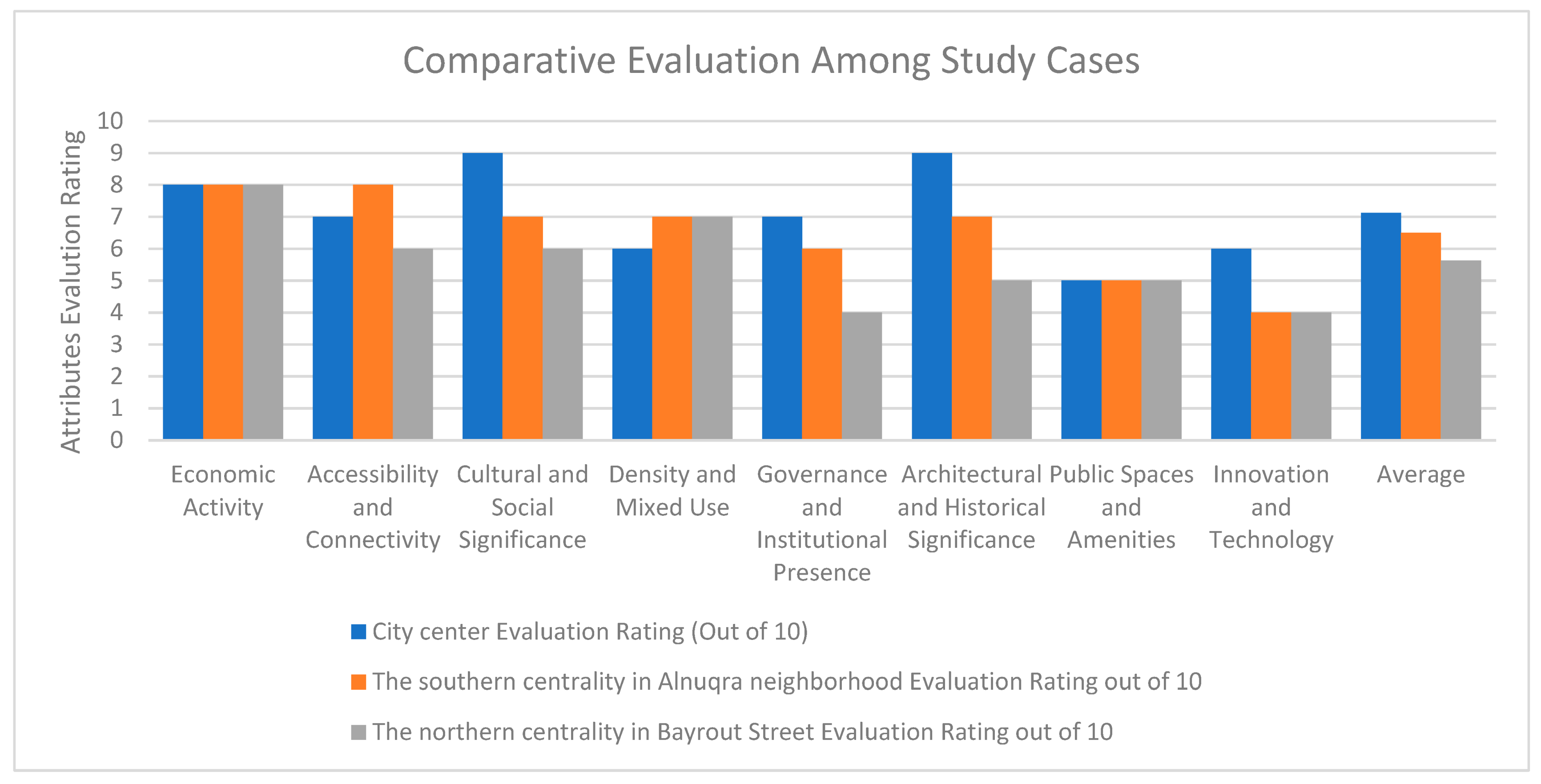
A comparative reading of
Figure 14 and
Figure 16 highlights distinct urban performance patterns. Alnuqra exhibits higher scores in accessibility, economic activity, and institutional presence, reflecting its strategic location and diversified functions. In contrast, Bayrout Street lags in governance, architectural distinction, and public space quality, despite having similar economic vibrancy. These contrasts suggest that while both centers are commercially active, Alnuqra is more spatially integrated and institutionally anchored, whereas Bayrout Street remains underdeveloped in terms of urban cohesion and identity. This comparative analysis reinforces the importance of balanced urban planning that aligns functional growth with spatial quality and cultural distinctiveness.
4.3.4. A Focus on the Newly Formed Centrality
The urban dynamics of Hail continue to evolve, shaped by changing social, economic, and spatial patterns. Recent observations reveal the emergence of new potential centers, particularly in the northern zone near the University of Hail. Although this region exhibits indications of evolving into a prominent urban center, its advancement remains inchoate, with a substantial portion of its prospective growth still contingent upon architectural and infrastructural initiatives that have yet to materialize.
At the same time, the southern district is experiencing the gradual formation of another emerging centrality, characterized by the growth of services, financial institutions, and cafés. Although this southern node is starting to establish itself as a local destination, its scale and impact remain more modest compared to the city’s established central areas that have been the focus of this research. These emerging centers suggest early signs of decentralization and spatial rebalancing within Hail’s urban fabric. However, their evolution remains highly contingent on future policy decisions, infrastructure investments, and socio-economic dynamics. Rather than forecasting definitive centralities, this section highlights spatial patterns that merit close monitoring and proactive planning. The identification of these zones should be understood as a diagnostic reflection—not a prediction—based on current developmental trajectories (
Figure 17).
5. Discussion
5.1. Permanence and Exchange in Spatial Dynamics
Urban development is fundamentally shaped by the interplay between permanence and exchange, two forces that determine a city’s capacity to remain rooted in its identity while evolving to meet contemporary demands. Permanence provides the historical, cultural, and socio-economic foundation upon which a city builds its character. It fosters continuity and place attachment, ensuring that urban spaces retain meaning across generations. Conversely, exchange introduces dynamism, innovation, and adaptability, enabling cities to renew themselves through the flow of people, capital, ideas, and cultural activities. These dynamics are evident in globally recognized urban centers such as Barcelona’s Gothic Quarter [
65,
66], which preserves medieval architecture while integrating modern cultural and commercial activities, or Istanbul’s Grand Bazaar, which thrives as both a historic landmark and a living economic hub [
67]. These examples illustrate that the vitality of urban centers depends on their ability to mediate between historical continuity and contemporary exchange.
5.2. Permanence in Urban Centers
In Hail, permanence is most visible in its preserved historical structures, traditional marketplaces, and long-standing social practices. The restoration of Barzan Palace and the continued relevance of traditional souks exemplify this anchoring role. Such elements not only provide cultural continuity but also support economic stability by maintaining attractions that are deeply rooted in local identity. This mirrors cases like Fez in Morocco, where the preservation of its Medina has sustained tourism and local craft economies [
68], or Aleppo’s Citadel, which remains a symbol of resilience and historical pride despite urban conflict [
69,
70,
71,
72]. These urban cores demonstrate how permanence, when properly managed, serves as a platform for civic pride, economic stability, and cultural transmission.
5.3. The Role of Exchange
While permanence anchors the past, exchange propels cities into the future. In Hail, the expansion of pedestrian zones, the growth of modern retail spaces, and the influx of service industries and cafés illustrate this dynamic force. Similar to how Kuala Lumpur’s Bukit Bintang district revitalized its identity through commercial and social activities [
73,
74], Hail’s modern developments contribute to a more vibrant urban economy. These spaces facilitate not only economic transactions but also social interactions and cultural expressions, contributing to the city’s evolving urban identity. However, unlike fully matured mixed-use districts in cities such as Copenhagen’s Strøget [
75], Hail’s emerging centers still require more intentional integration of public spaces and social infrastructure to fully harness the benefits of exchange.
5.4. Balancing Change with Stability
Achieving a balance between preserving identity and embracing change is a core urban challenge. Hail’s planning efforts reflect an incipient model of this balance, as seen in the protection of historic sites alongside the promotion of contemporary commercial developments. However, this balance remains fragile. Lessons can be drawn from Paris’ approach to heritage-led urban regeneration [
76,
77], which protects historical continuity while introducing adaptive reuse strategies that keep the city economically and socially relevant. Hail must similarly ensure that modernization does not marginalize its cultural assets or community needs but rather enhances them through inclusive, context-sensitive development.
While sustainable development and urban resilience are interrelated, they operate through different logics: the former aims to meet intergenerational goals across three pillars (economic, social, and environmental), whereas the latter emphasizes a city’s adaptive capacity under uncertainty. This study treats resilience as a dynamic process that complements but is distinct from sustainability. Urban centrality contributes to resilience by enabling redundancy in services, concentration of adaptive capacities, and flexible infrastructure connectivity, especially in the face of shifting economic and demographic conditions.
5.5. Spatial Dynamics as a Catalyst
Spatial dynamics, including street networks, public spaces, and accessibility, serve as catalysts for both preserving heritage and stimulating contemporary urban life. Hail’s recent improvements in the Barzan Market area highlight how strategic spatial design can activate historical centers. However, the emergence of fragmented new centers in the northern and southern districts presents a spatial governance challenge. Without coordinated infrastructure and accessibility improvements, these areas risk becoming isolated or unevenly integrated into the city’s functional core. Comparative experiences from cities like Medina’s urban expansion show that poorly connected new developments can dilute urban cohesion [
78,
79], while successful cases like Singapore’s Marina Bay demonstrate the value of master-planned integration that ties new developments to the existing urban fabric [
80,
81].
Comparative analysis of Hail’s three urban centralities further illustrates these spatial dynamics in action. The evaluation reveals distinct performance patterns, with the historic city center achieving the highest overall rating (7.125), followed by the southern centrality in Alnuqra neighborhood (6.5), and the northern centrality in Bayrout Street scoring the lowest (5.625). The city center stands out for its strong cultural and architectural significance, supported by a stable economic base and institutional presence, though it still faces challenges in public space quality and technological modernization. Alnuqra, while emerging as a vibrant commercial hub with good connectivity, shows weaker performance in governance and technological readiness, indicating the need for enhanced service provision and digital infrastructure. Bayrout Street, despite its economic activity, remains underdeveloped in terms of connectivity, cultural identity, institutional presence, and innovation, highlighting the need for targeted urban planning strategies to strengthen its role within the city’s central network. These results suggest that while the city center retains its dominance, balanced investment in infrastructure, cultural programming, and smart technologies is essential to elevate the performance of Hail’s emerging urban nodes (
Figure 18).
While much of the discourse on urban centrality draws from the historical nucleus, this study’s findings show that significant spatial reconfiguration is occurring in Hail’s expanded urban areas, particularly in Alnuqra and Bayrout Street. These emerging nodes represent new expressions of centrality shaped by commercial clustering, social activity, and accessibility rather than historical symbolism. Alnuqra’s high scores in economic vibrancy and spatial connectivity reflect a shift in centrality logic where accessibility and consumption culture define value. Conversely, Bayrout Street illustrates the risks of uneven development in peripherally expanding areas, with economic functions advancing faster than civic or cultural infrastructure. Integrating these areas into the city’s planning framework requires flexible design tools, participatory governance, and context-sensitive policies that recognize both the opportunities and disparities emerging in the expanding urban fabric.
The evolution of Hail’s urban centrality, therefore, requires proactive and adaptive planning that anticipates future shifts while safeguarding the city’s heritage and social cohesion. Urban planners are required to meticulously assess the enduring consequences of spatial decisions, guaranteeing that forthcoming investments in infrastructure, services, and public spaces are systematically congruent with the city’s historical character and prospective goals. By maintaining this delicate equilibrium between permanence and change, Hail can position itself as a resilient, inclusive, and dynamic urban hub, capable of sustaining both its traditions and its trajectory toward modernization.
6. Policy Recommendations: Toward Balanced Urban Centrality in Hail
This study presents a grounded framework for advancing urban resilience and sustainability in Hail through the lens of spatial centrality. Drawing from theoretical models and empirical observations, several actionable recommendations emerge, each aligned with the eight identified centrality attributes. Rather than treating these attributes in isolation, an integrated policy response is needed—one that considers the interplay between economic, spatial, institutional, and technological systems.
To strengthen economic activity in both historical and emerging nodes, local government and regional development agencies should implement incentives for mixed-use development and small business incubation—particularly in heritage-rich areas like Barzan and in under-served growth corridors like Bayrout Street. This could be supported through municipal planning departments and local chambers of commerce.
On the accessibility front, the Ministry of Municipal and Rural Affairs and Housing (MoMRAH), in coordination with the Hail Municipality, should invest in multimodal transport solutions, including public transit links between core and peripheral areas, pedestrianization projects, and digital navigation tools that enhance user mobility. These interventions should be embedded in Hail’s broader transportation master plan.
Preserving cultural identity and fostering social inclusion requires targeted policies by heritage authorities (e.g., the Heritage Commission) to protect key landmarks, while also encouraging cultural events and placemaking activities that revitalize public life in historic quarters. This can be achieved through public–private partnerships and community-led cultural programming.
Compact urban form and land-use diversity can be promoted through regulatory tools such as revised zoning ordinances and density bonuses that encourage vertical integration of commercial and residential functions in central corridors. MoMRAH and the Hail Urban Planning Directorate are the appropriate implementing agencies.
Institutional presence and participatory governance must be expanded beyond the historic core. Decentralizing civic services—such as licensing offices, health clinics, or digital service hubs—into neighborhoods like Alnuqra and Bayrout can enhance access and reinforce spatial equity. Engagement mechanisms such as local planning councils or neighborhood forums could foster accountability and grassroots inclusion.
Heritage conservation should not be limited to symbolic preservation but should include adaptive reuse policies that permit historic buildings to host cultural, commercial, or civic activities. This approach requires coordination between heritage agencies and urban planning departments and could be formalized through municipal heritage management plans.
Improving the quality of public space and urban amenities necessitates collaborative design approaches led by planning professionals, architects, and municipal engineers. This includes creating shaded walkways, seating, and micro-parks that address pedestrian comfort and social engagement.
Finally, the integration of smart and inclusive technology should be elevated from passive surveillance to active urban management. Hail can benefit from piloting smart infrastructure in public spaces, digital service delivery portals, and real-time mobility monitoring. These should be governed by municipal innovation offices or smart city task forces, with support from national digital transformation strategies.
Collectively, these recommendations aim to translate this study’s findings into implementable urban planning actions that enhance Hail’s urban resilience, sustainability, and livability at both municipal and regional scales.
7. Limitations and Broader Implications
While this research provides insights into the spatial and functional dynamics of urban centrality in Hail, several limitations must be acknowledged. First, the scope of field observations and data collection was limited to selected districts, primarily Alnuqra and Bayrout Street, which may not fully capture the complexity of other emerging or peripheral urban areas. Second, although the utilization of a mixed-methods approach augmented the analytical depth, the accessibility of contemporary spatial data and the engagement of stakeholders presented significant challenges, thereby restricting the granularity of certain assessments. Additionally, the technology assessment was largely observational, without access to internal municipal data on smart city infrastructure or future digitalization plans, which may have restricted the assessment of technological readiness. Lastly, the findings are context-specific to Hail, and while they offer transferable lessons, their application to other cities requires contextual adaptation.
Notwithstanding these constraints, the research presents numerous overarching implications for urban planning and the formulation of policy. First, it reinforces the importance of spatial thinking and multi-scalar analysis in understanding how urban centrality influences citywide resilience, social cohesion, and economic vitality. Second, it highlights the value of integrating local heritage with modern urban development, providing a replicable model for medium-sized cities seeking to balance identity and growth. Third, the results underscore the imperative of allocating resources towards the development of inclusive infrastructure and governance frameworks, especially within nascent urban centers, to avert urban fragmentation and guarantee equitable availability of services and opportunities. Finally, this study points to the critical role of adaptive and participatory planning processes that respond to local dynamics while anticipating future socio-economic and technological changes. These insights can inform not only local strategies in Hail but also broader urban policy frameworks aimed at fostering sustainable, inclusive, and resilient urban environments globally.
8. Conclusions
This research has critically examined the role of urban centrality as a catalyst for shaping the economic, social, and spatial dynamics of Hail, Saudi Arabia. Through a mixed-methods approach, combining quantitative spatial analysis with field-based observations and stakeholder insights, this study has demonstrated how central areas serve as key drivers of urban resilience and vitality. By analyzing the spatial performance of established and emerging centers—such as Alnuqra neighborhood and Bayrout Street—the research reveals the complex interplay between permanence and change, highlighting how historical identity and modern development coexist and influence the city’s evolving landscape.
The findings underscore that Hail’s urban transformation is driven by factors such as economic diversification, demographic shifts, technological innovation, and cultural dynamics. These drivers necessitate proactive, inclusive, and adaptive urban planning strategies that safeguard heritage while facilitating contemporary growth. This study shows that strategic investments in accessibility, mixed-use development, public space quality, and technological integration are essential to ensuring balanced and sustainable urban development.
Ultimately, this research advances both academic understanding and professional practice by emphasizing the critical role of spatial dynamics in urban planning. The case of Hail offers transferable insights for other cities facing similar challenges, demonstrating the importance of integrated development approaches that connect economic, social, cultural, and technological dimensions. This investigation establishes a pivotal basis for forthcoming scholarly inquiries and policy initiatives directed towards the development of resilient, inclusive, and dynamic urban environments that honor local identity whilst accommodating the exigencies of an increasingly fluid global milieu.


 ,
, 


