


AI-Based Identification and Redevelopment Prioritization of Inefficient Industrial Land Using Street View Imagery and Multi-Criteria Modeling
Abstract
1. Introduction
2. Materials and Methods
2.1. Identification of IIL
2.1.1. Screening of Economically Inefficient Industrial Land
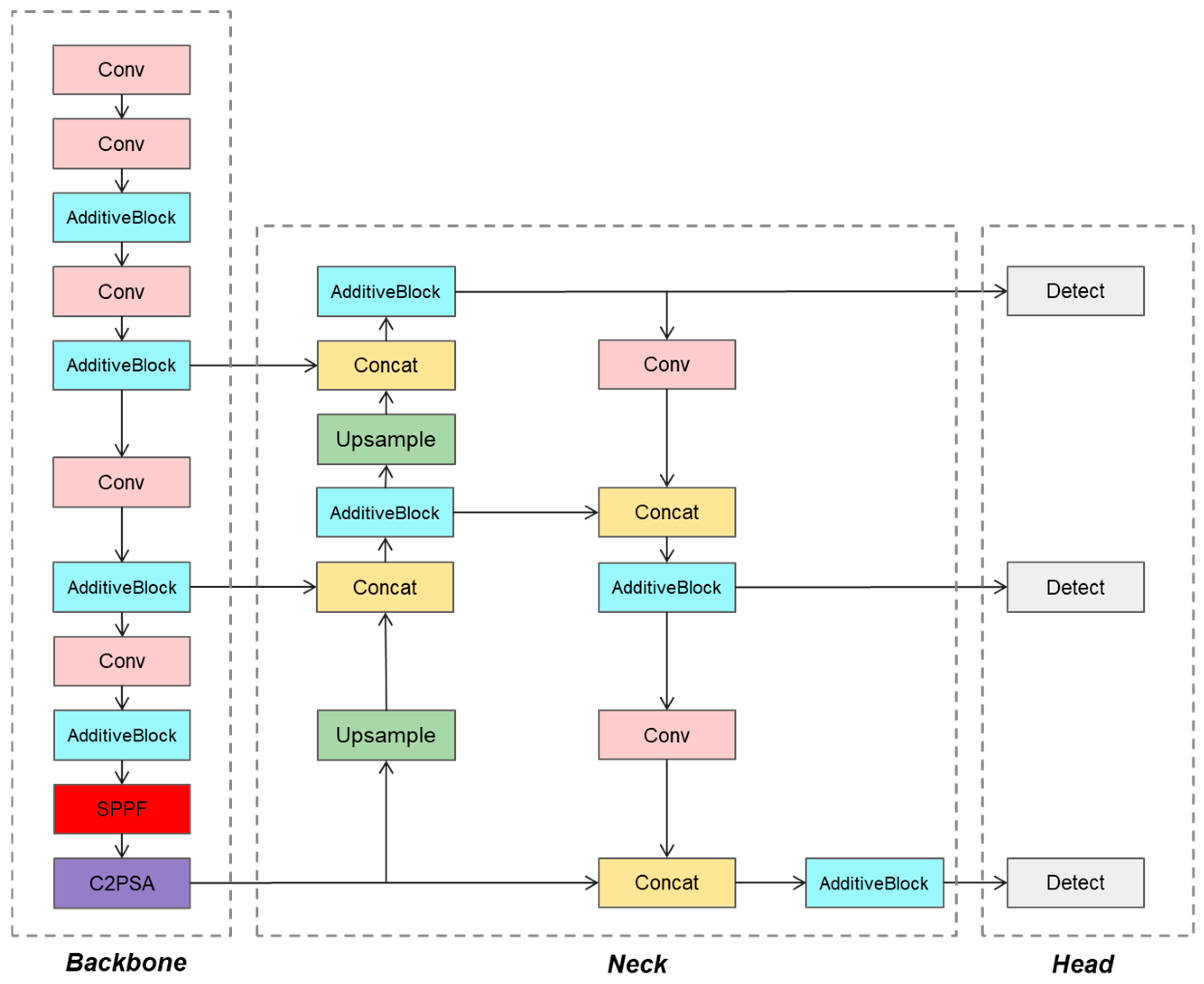
2.1.2. Abandoned Building Identification Model Based on Improved YOLOv11
2.1.3. IIL Identification Integrating Economic and Building Features
2.2. Redevelopment Prioritization of IIL
2.2.1. Redevelopment Potential Evaluation Index System of IIL
2.2.2. Evaluation of Redevelopment Potential
3. Study Area and Data
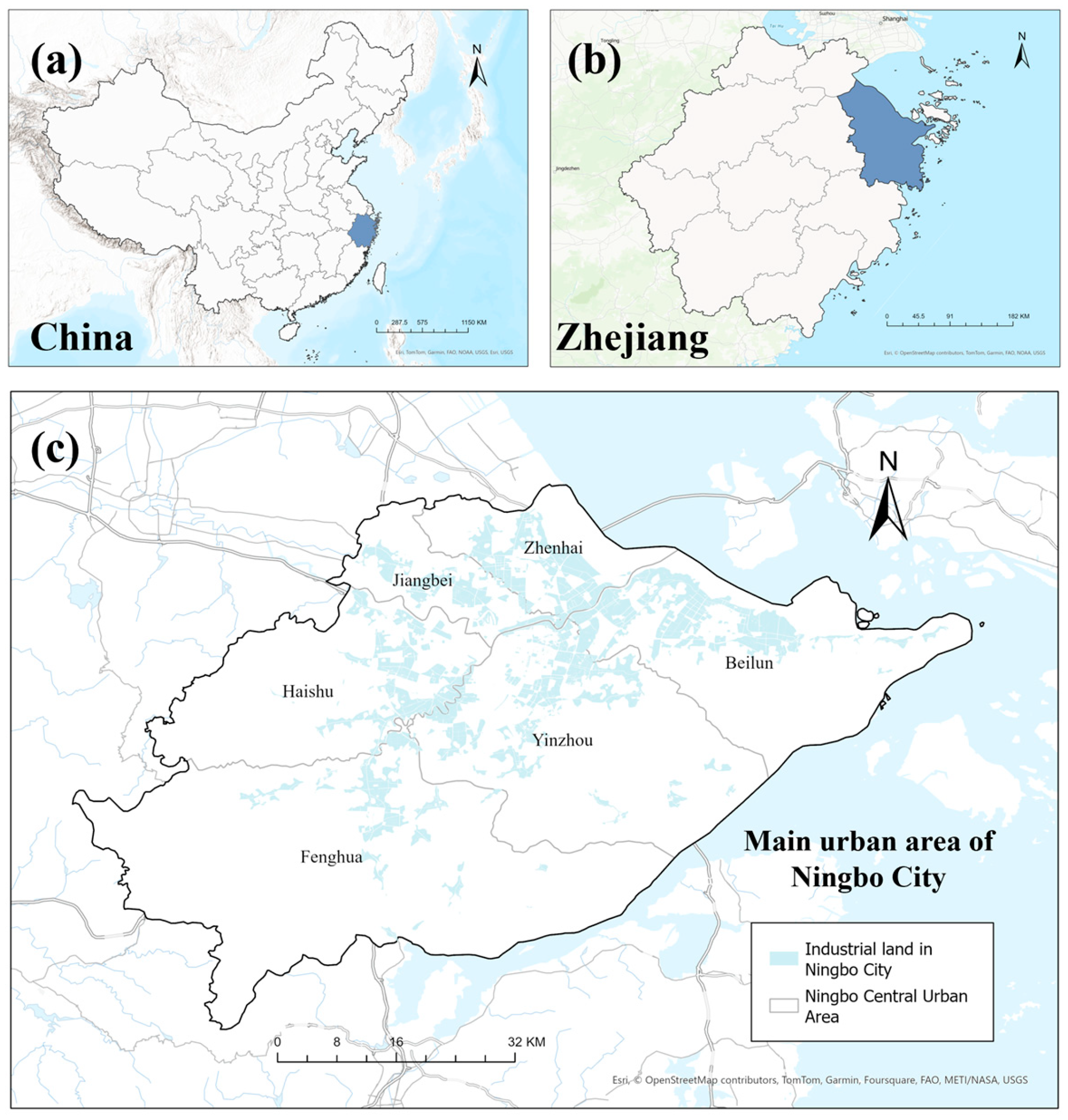
3.1. Study Area
3.2. Data Sources
4. Results
4.1. Identification Results of IIL in the Central Urban Area of Ningbo City
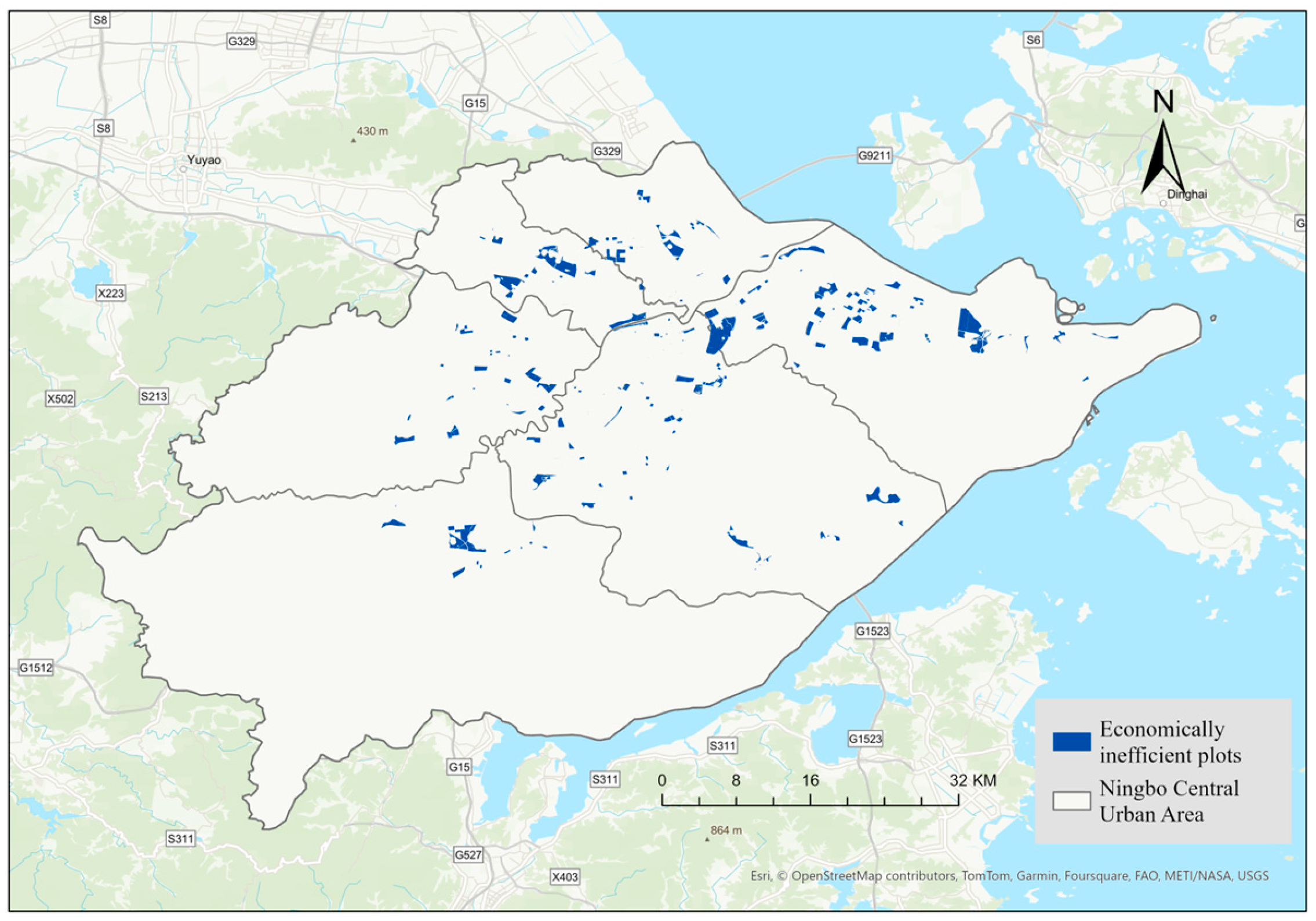
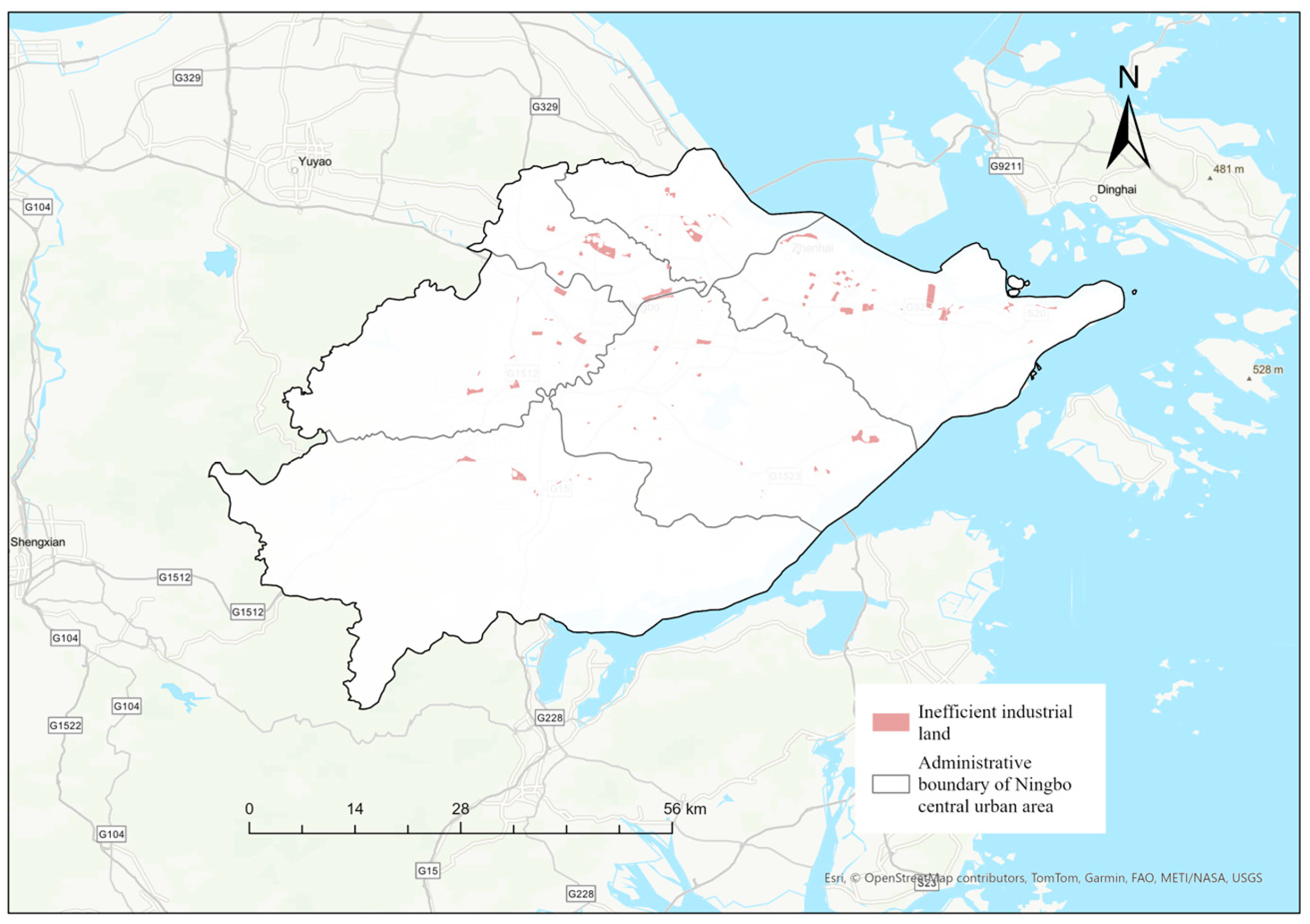
4.1.1. Identification Results of Economically IIL in the Central Urban Area of Ningbo City
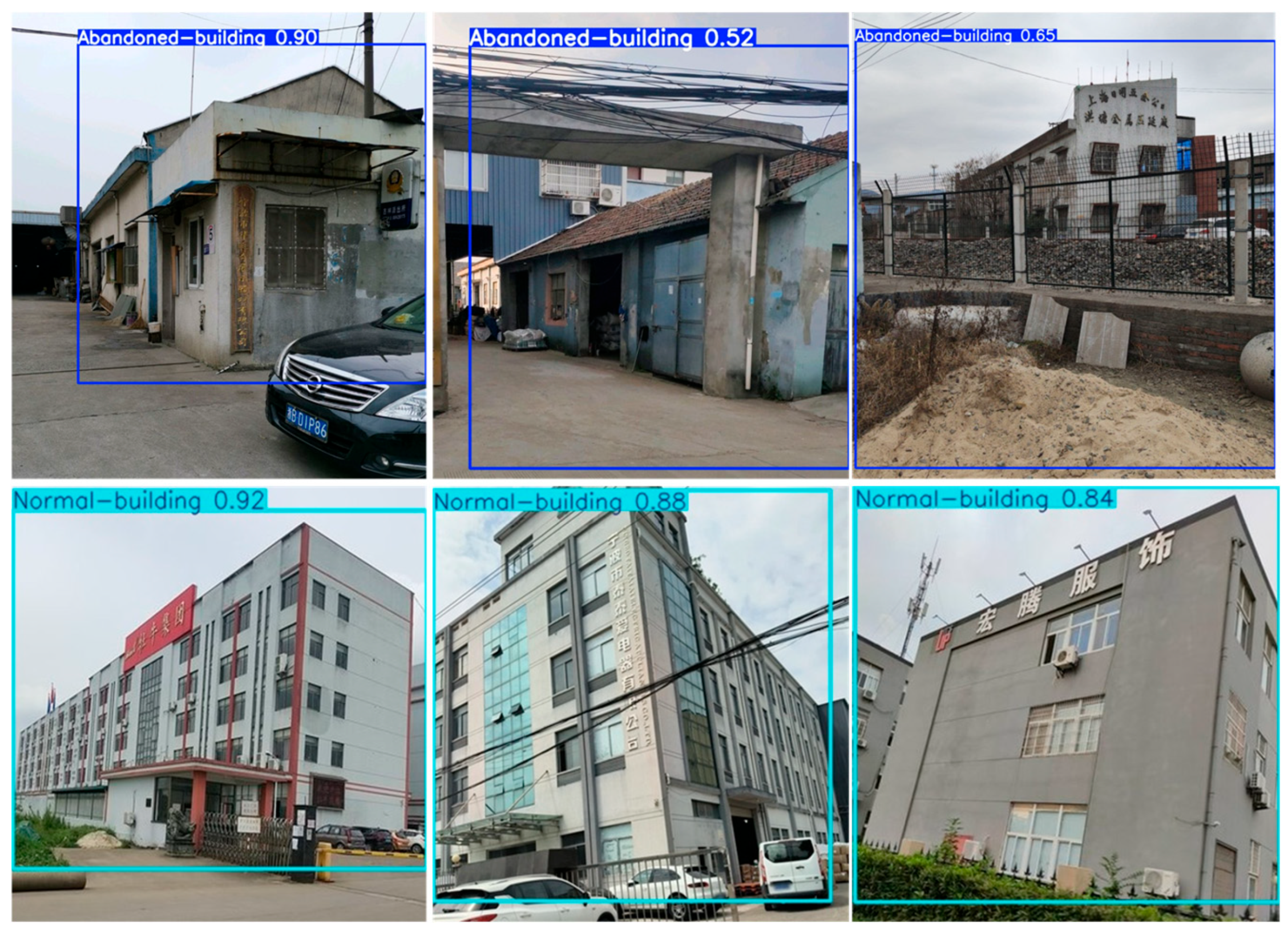
4.1.2. Training and Verification of Abandoned Building Identification Model
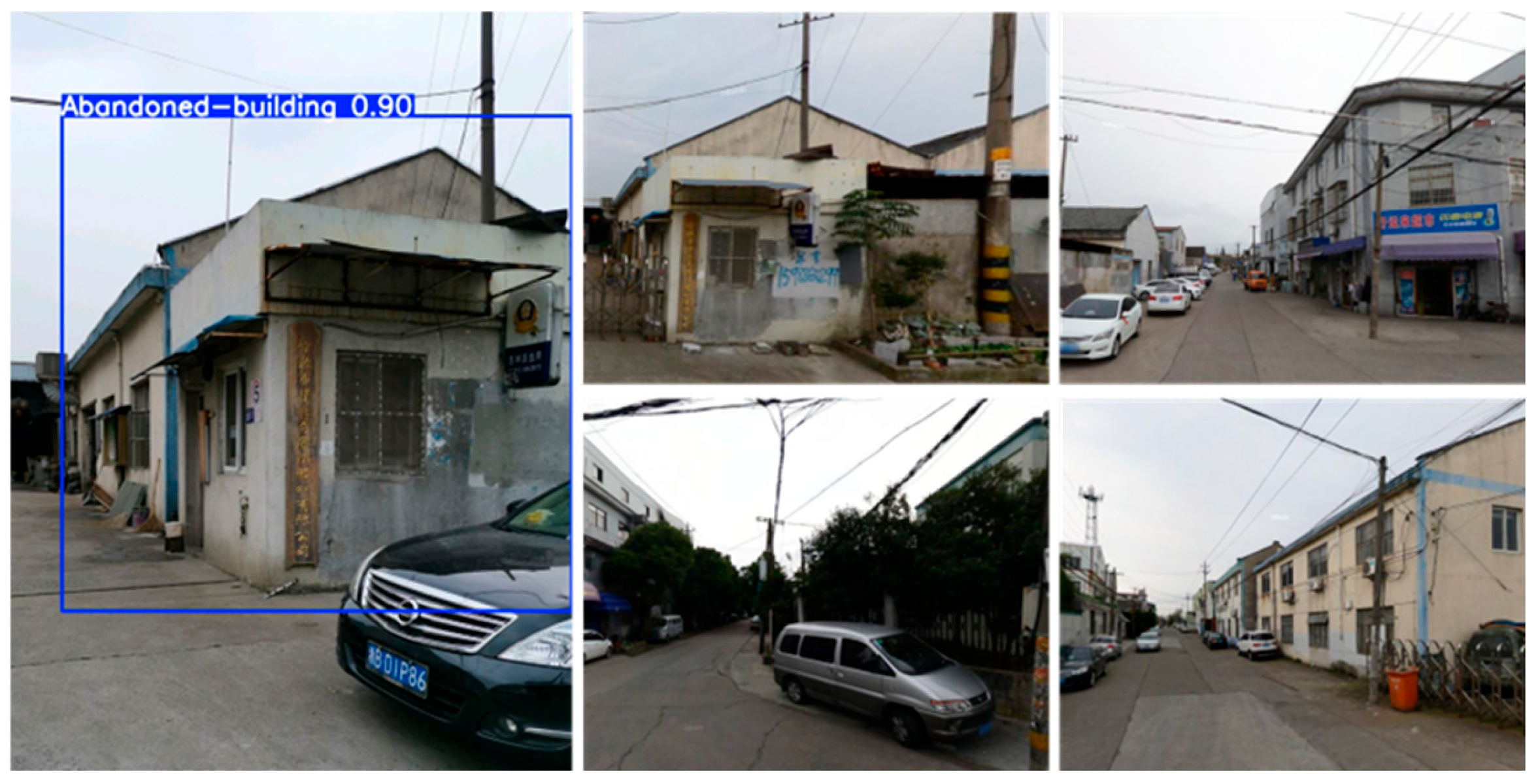
4.1.3. Identification Results of IIL Based on Abandoned Building Identification Model
4.2. Redevelopment Prioritization Results of IIL in the Central Urban Area of Ningbo City
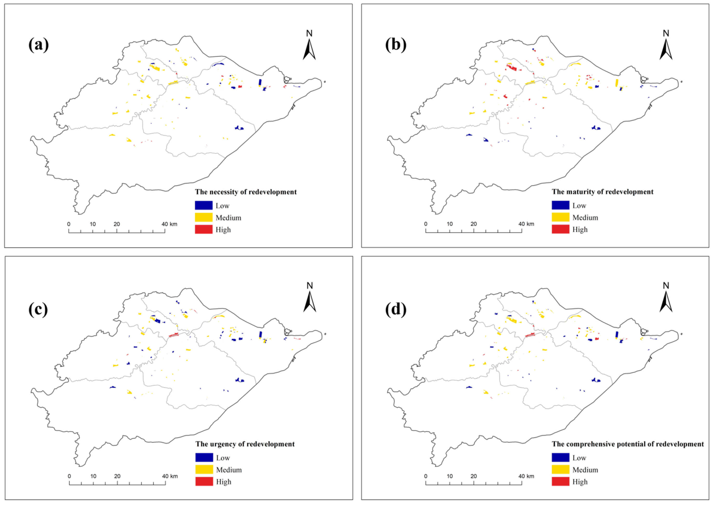
4.2.1. Redevelopment Potential Evaluation Results of IIL
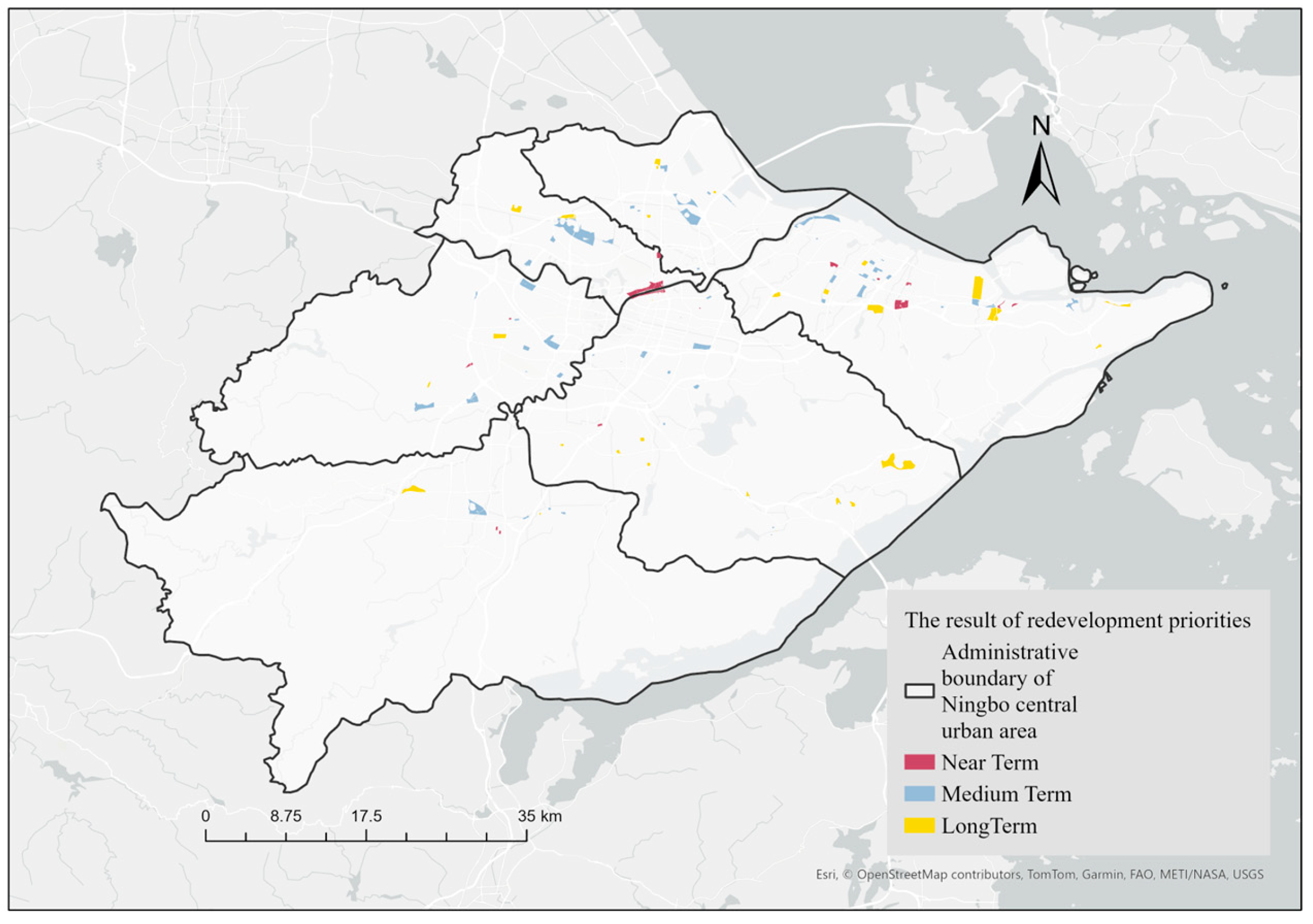
4.2.2. Redevelopment Priority Determination Results of IIL
5. Discussion
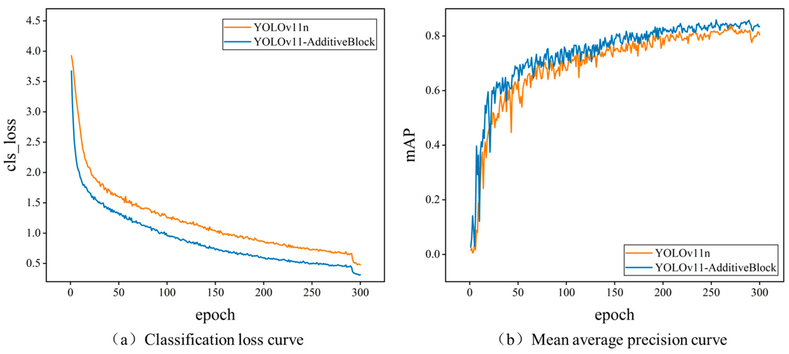
5.1. Precision Comparison of Abandoned Building Identification Models
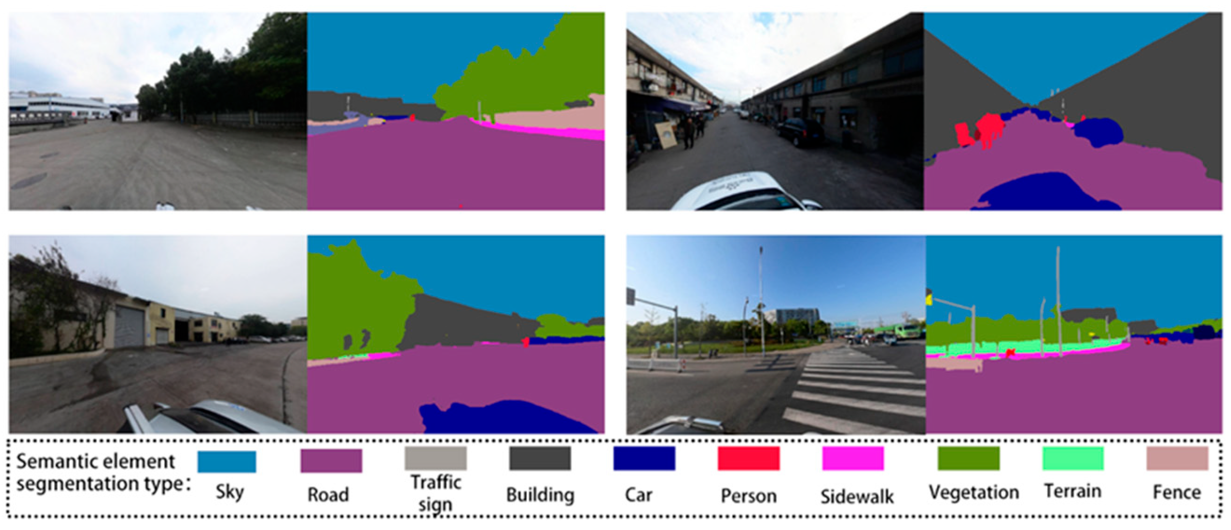
5.2. Effective Use of Street View Images
5.3. Portability of the Framework
5.4. Policy Impact and Space Utilization Suggestions
- (1)
- Funding prioritization for near-term redevelopment areas: For parcels classified by the model as “near-term redevelopment,” it is recommended that they be included in the scope of urban renewal special funds, accompanied by tax incentives to attract private investment.
- (2)
- Public–private partnership (PPP) guidance: For high-readiness sites, we suggest that the government lead infrastructure upgrades and introduce industrial operators through PPP models to develop “industrial–innovation” integrated zones.
- (3)
- Environmental regulation and industrial exit mechanisms: For polluted parcels identified under the “urgency” dimension we recommend enforcing compulsory relocation in line with the Key Environmental Supervision Entity List and prioritizing the introduction of green manufacturing or digital economy industries.
6. Conclusions
- (1)
- This study integrates street view imagery (SVI) with deep learning to identify IIL, improving both the accuracy and efficiency of the identification process. An abandoned building identification model based on an improved YOLOv11 architecture, trained on a self-constructed dataset (achieving a mAP of 80.1%) was applied to detect object-level features in economically inefficient plots. The results demonstrate the effectiveness and scalability of this image-based identification approach.
- (2)
- A redevelopment potential evaluation index system was established from the following three perspectives: necessity, maturity, and urgency. By incorporating SVI-derived indicators the model captures physical and environmental characteristics often overlooked in traditional evaluation systems. The use of the PSO-PP model further ensures an objective, data-driven evaluation process, reducing reliance on expert judgment and enabling adaptive prioritization.
- (3)
- Based on the comprehensive redevelopment potential scores, the identified IIL plots were categorized into the following three priority phases: near-term, medium-term, and long-term. This provides urban planners and public managers with a practical and systematic reference for phased redevelopment, enhancing the efficiency and orderliness of urban land revitalization.
Author Contributions
Funding
Data Availability Statement
Conflicts of Interest
References
- Feng, X.; Xu, M.; Li, J.; Gao, Z. Analysis of China’s Industrial Network Structure and Its Resilience from the Sectoral Perspective. Habitat Int. 2024, 153, 103192. [Google Scholar] [CrossRef]
- Wei, C.; Qiao, L.; Sun, Z.; Xue, Z. Can Industrial Structure Upgrading Restrain Industrial Land Expan- Sion? Evidence from China. Chin. Geogr. Sci. 2024, 34, 504–518. [Google Scholar]
- Tian, C.; Luan, W.; Wang, X.; Jin, X. Land price, government debt, and land-use efficiency in the coastal cities of China under the constraint of land scarcity. J. Environ. Manag. 2024, 371, 123144. [Google Scholar] [CrossRef] [PubMed]
- He, F.; Yi, Y.; Si, Y. Evolution Process of Urban Industrial Land Redevelopment in China: A Perspective of Original Land Users. Land 2024, 13, 548. [Google Scholar] [CrossRef]
- Han, Q.; Ke, G.Y. Analyzing the Financing Dilemma of Brownfield Remediation in China by Using GMCR. In Proceedings of the 2016 IEEE International Conference on Systems, Man, and Cybernetics (SMC), Budapest, Hungary, 9–12 October 2016; pp. 2431–2435. [Google Scholar]
- Zhang, H.; Liu, G.; Han, Q.; Chen, G. Mapping the Barriers of Utilizing Public Private Partnership into Brownfield Remediation Projects in the Public Land Ownership. Land 2023, 12, 73. [Google Scholar] [CrossRef]
- Pamuković, J.K.; Rogulj, K.; Jajac, N.; Mastelić-Ivić, S. Model of Priority Ranking of Cadastral Parcels for Planning the Implementation of Urban Consolidation. Land 2023, 12, 148. [Google Scholar] [CrossRef]
- Jin, R.; Huang, C.; Wang, P.; Ma, J.; Wan, Y. Identification of Inefficient Urban Land for Urban Regeneration Considering Land Use Differentiation. Land 2023, 12, 1957. [Google Scholar] [CrossRef]
- Wang, Z.; Chen, X.; Huang, N.; Yang, Y.; Wang, L.; Wang, Y. Spatial Identification and Redevelopment Evaluation of Brownfields in the Perspective of Urban Complex Ecosystems: A Case of Wuhu City, China. Int. J. Environ. Res. Public Health 2022, 19, 478. [Google Scholar] [CrossRef]
- Kurowska, A.; Nowogońska, B. Influence of the Decision to Select Renovated Elements in a Heritage Building on Further Stages of the Aging Process of the Building—A Case Study. Sustainability 2023, 15, 16926. [Google Scholar] [CrossRef]
- Yin, L.; Silverman, R.M. Housing Abandonment and Demolition: Exploring the Use of Micro-Level and Multi-Year Models. ISPRS Int. J. Geo-Inf. 2015, 4, 1184–1200. [Google Scholar] [CrossRef]
- Xu, F.; Jin, A.; Chen, X.; Li, G. New Data, Integrated Methods and Multiple Applications: A Review of Urban Studies Based on Street View Images. In Proceedings of the 2021 IEEE International Geoscience and Remote Sensing Symposium IGARSS, Brussels, Belgium, 11–16 July 2021; pp. 6532–6535. [Google Scholar]
- Roussel, R.; Jacoby, S.; Asadipour, A. Robust Building Identification from Street Views Using Deep Convolutional Neural Networks. Buildings 2024, 14, 578. [Google Scholar] [CrossRef]
- Yang, Z.; Li, S.; Sun, D.; Li, C.; Wu, J. Intensive Evaluation and High-Quality Redevelopment of Enterprise Land Use: A Case Study in China. Land 2022, 11, 432. [Google Scholar] [CrossRef]
- Preston, P.D.; Dunk, R.M.; Smith, G.R.; Cavan, G. Not all brownfields are equal: A typological assessment reveals hidden green space in the city. Landsc. Urban Plan. 2023, 229, 104590. [Google Scholar] [CrossRef]
- Hammond, E.B.; Coulon, F.; Hallett, S.H.; Thomas, R.; Dick, A.; Hardy, D.; Dickens, M.; Washbourn, E.; Beriro, D.J. From data to decisions: Empowering brownfield redevelopment with a novel decision support system. J. Environ. Manag. 2023, 347, 119145. [Google Scholar] [CrossRef]
- Teng, J.K. Research on Benefit Measurement of Urban Inefficient Land Redevelopment Based on Smart Growth Theory. Master’s Thesis, Shandong Jianzhu University, Jinan, China, 2024. [Google Scholar]
- Cheng, F.; Geertman, S.; Kuffer, M.; Zhan, Q. An integrative methodology to improve brownfield redevelopment planning in Chinese cities: A case study of Futian, Shenzhen. Comput. Environ. Urban Syst. 2011, 35, 388–398. [Google Scholar] [CrossRef]
- Pan, W.; Du, J. Towards Sustainable Urban Transition: A Critical Review of Strategies and Policies of Urban Village Renewal in Shenzhen, China. Land Use Policy 2021, 111, 105744. [Google Scholar] [CrossRef]
- He, J.; Zhang, J.; Yao, Y.; Li, X. Extracting Human Perceptions from Street View Images for Better Assessing Urban Renewal Potential. Cities 2023, 134, 104189. [Google Scholar] [CrossRef]
- Jian, H.; Hao, H.; Haidan, J.; Haize, P.; Chuan, L. Brownfield Redevelopment Evaluation Based on Structure-Process-Outcome Theory and Continuous Ordered Weighted Averaging Operator-Topology Method. Sci. Rep. 2023, 13, 17530. [Google Scholar] [CrossRef]
- Wang, K.; Xu, F. Slope Stability Evaluation Based on PSO-PP. Appl. Mech. Mater. 2014, 580–583, 486–489. [Google Scholar] [CrossRef]
- Liu, D.; Zhang, G.; Li, H.; Fu, Q.; Li, M.; Faiz, M.A.; Ali, S.; Li, T.; Imran Khan, M. Projection Pursuit Evaluation Model of a Regional Surface Water Environment Based on an Ameliorative Moth-Flame Optimization Algorithm. Ecol. Indic. 2019, 107, 105674. [Google Scholar] [CrossRef]
- Xu, D.; Liu, D.; Liu, D.; Fu, Q.; Huang, Y.; Li, M.; Li, T. New Method for Diagnosing Resilience of Agricultural Soil-Water Resource Composite System: Projection Pursuit Model Modified by Sparrow Search Algorithm. J. Hydrol. 2022, 610, 127814. [Google Scholar] [CrossRef]
- Perschewski, J.-O.; Schmidt, J.; Stober, S. Pursuing the Perfect Projection: A Projection Pursuit Framework for Deep Learning. In Advances in Self-Organizing Maps, Learning Vector Quantization, Interpretable Machine Learning, and Beyond; Villmann, T., Kaden, M., Geweniger, T., Schleif, F.-M., Eds.; Springer: Cham, Switzerland, 2024; pp. 43–52. [Google Scholar]
- Han, Z.; Long, Y.; Wang, X.; Hou, J. Urban Redevelopment at the Block Level: Methodology and Its Application to All Chinese Cities. Environ. Plan. B Urban Anal. City Sci. 2019, 47, 1725–1744. [Google Scholar] [CrossRef]
- Foley, T.; Wolf, A.M.; Jackson, C.; Stephenson, R. Development of a Brownfield Inventory for Prioritizing Funding Outreach in Tucson, Arizona. Geospat. Inf. Sci. 2021, 24, 742–754. [Google Scholar] [CrossRef]
- Greenaway-McGrevy, R.; Pacheco, G.; Sorensen, K. The Effect of Upzoning on House Prices and Redevelopment Premiums in Auckland, New Zealand. Urban Stud. 2021, 58, 959–976. [Google Scholar] [CrossRef]
- Wedding, G.C.; Crawford-Brown, D. Measuring Site-Level Success in Brownfield Redevelopments: A Focus on Sustainability and Green Building. J. Environ. Manag. 2007, 85, 483–495. [Google Scholar] [CrossRef]
- Hussain, M. YOLO-v1 to YOLO-v8, the Rise of YOLO and Its Complementary Nature toward Digital Manufacturing and Industrial Defect Detection. Machines 2023, 11, 677. [Google Scholar] [CrossRef]
- Cheng, S.; Han, Y.; Wang, Z.; Liu, S.; Yang, B.; Li, J. An Underwater Object Recognition System Based on Improved YOLOv11. Electronics 2025, 14, 201. [Google Scholar] [CrossRef]
- Zou, C.; Yu, S.; Yu, Y.; Gu, H.; Xu, X. Side-Scan Sonar Small Objects Detection Based on Improved YOLOv11. J. Mar. Sci. Eng. 2025, 13, 162. [Google Scholar] [CrossRef]
- Zhang, T.; Li, L.; Zhou, Y.; Liu, W.; Qian, C.; Hwang, J.N.; Ji, X. Cas-ViT: Convolutional Additive Self-Attention Vision Transformers for Efficient Mobile Applications. arXiv 2024, arXiv:2408.03703. [Google Scholar]
- Tian, Z.; Yang, F.; Yang, L.; Wu, Y.; Chen, J.; Qian, P. An Optimized YOLOv11 Framework for the Efficient Multi-Category Defect Detection of Concrete Surface. Sensors 2025, 25, 1291. [Google Scholar] [CrossRef]
- Liu, Y.; Zhu, A.-X.; Wang, J.; Li, W.; Hu, G.; Hu, Y. Land-Use Decision Support in Brownfield Redevelopment for Urban Renewal Based on Crowdsourced Data and a Presence-and-Background Learning (PBL) Method. Land Use Policy 2019, 88, 104188. [Google Scholar] [CrossRef]
- Hou, D.; Al-Tabbaa, A.; Chen, H.; Mamic, I. Factor Analysis and Structural Equation Modelling of Sustainable Behaviour in Contaminated Land Remediation. J. Clean. Prod. 2014, 84, 439–449. [Google Scholar] [CrossRef]
- Szabó, M.; Bozsoki, F. Redevelopment of Brownfields for Cultural Use from ERDF Fund—The Case of Hungary between 2014 and 2020. J. Risk Financ. Manag. 2022, 15, 181. [Google Scholar] [CrossRef]
- Turečková, K.; Nevima, J.; Duda, D.; Tuleja, P. Latent Structures of Brownfield Regeneration: A Case Study of Regions of the Czech Republic. J. Clean. Prod. 2021, 311, 127478. [Google Scholar] [CrossRef]
- Ahmad, N.; Zhu, Y.; Ibrahim, M.; Waqas, M.; Waheed, A. Development of a Standard Brownfield Definition, Guidelines, and Evaluation Index System for Brownfield Redevelopment in Developing Countries: The Case of Pakistan. Sustainability 2018, 10, 4347. [Google Scholar] [CrossRef]
- Shami, T.M.; El-Saleh, A.A.; Alswaitti, M.; Al-Tashi, Q.; Summakieh, M.A.; Mirjalili, S. Particle Swarm Optimization: A Comprehensive Survey. IEEE Access 2022, 10, 10031–10061. [Google Scholar] [CrossRef]
- Zeng, S.; Fang, Z.; He, Y.; Huang, L. An Integrated Entropy-COPRAS Framework for Ningbo-Zhoushan Port Logistics Development from the Perspective of Dual Circulation. Systems 2022, 10, 131. [Google Scholar] [CrossRef]
- Fang, Y.; Yu, H.; Chen, Y.; Fu, X. Spatial Distribution Characteristics and Influencing Factors of the Retail Industry in Ningbo City in Eastern China Based on POI Data. Sustainability 2024, 16, 7525. [Google Scholar] [CrossRef]
- Che, Y.; Li, X.; Liu, X.; Wang, Y.; Liao, W.; Zheng, X.; Zhang, X.; Xu, X.; Shi, Q.; Zhu, J.; et al. 3D-GloBFP: The First Global Three-Dimensional Building Footprint Dataset. Earth Syst. Sci. Data Discuss. 2024, 16, 5357–5374. [Google Scholar] [CrossRef]
- Hu, W.; Zhang, Y.; Liang, Y.; Yin, Y.; Georgescu, A.; Tran, A.; Kruppa, H.; Ng, S.K.; Zimmermann, R. Beyond Geo-Localization: Fine-Grained Orientation of Street-View Images by Cross-View Matching with Satellite Imagery. In Proceedings of the 30th ACM International Conference on Multimedia (MM ’22), Lisbon, Portugal, 10 October 2022; ACM: New York, NY, USA, 2022; pp. 6155–6164. [Google Scholar]
- Cordts, M.; Omran, M.; Ramos, S.; Rehfeld, T.; Enzweiler, M.; Benenson, R.; Franke, U.; Roth, S.; Schiele, B. The Cityscapes Dataset for Semantic Urban Scene Understanding. In Proceedings of the IEEE Conference on Computer Vision and Pattern Recognition (CVPR), Las Vegas, NV, USA, 27–30 June 2016; IEEE: New York, NY, USA, 2016; pp. 3213–3223. [Google Scholar]
- Xie, E.; Wang, W.; Yu, Z.; Anandkumar, A.; Alvarez, J.M.; Luo, P. SegFormer: Simple and Efficient Design for Semantic Segmentation with Transformers. Adv. Neural Inf. Process. Syst. 2021, 34, 12077–12090. [Google Scholar]


| Subsets | Images | Instances | Abandoned Buildings |
|---|---|---|---|
| Training set | 1076 | 1641 | 42.4% |
| Validation set | 146 | 223 | 43.0% |
| Test set | 146 | 234 | 42.3% |
| Guideline Layer | Indicator | Description |
|---|---|---|
| Necessity | Average employment | The number of employees per unit area in each plot. |
| Per-mu tax revenue | The annual tax value per unit area in the plot. | |
| Per-mu output value | The annual output value per unit area in the plot. | |
| Per-mu industrial added value | The industrial added value per unit area in the plot. | |
| Annual revenue | The total annual income in the plot. | |
| Building height | The average building height of each plot | |
| Building density | The ratio of total building area to land area in each plot. | |
| Maturity | Traffic convenience | The ratio of the total number of traffic type POIs within the plot to the area size. |
| Street network density | The ratio of the total street network length within the plot to the area size. | |
| Industrial agglomeration | The ratio of the total number of enterprises and companies POIs within the plot to the area size. | |
| Sky view factor | Measures the fraction of the sky visible from SVI, indicating the openness of a plot. | |
| Greenery coverage ratio | Represents the proportion of an area covered by vegetation, reflecting the availability of green spaces. | |
| Waterfront accessibility | The density of water resources around the plot. | |
| Urgency | Prohibited and eliminated industrial land | Determines whether the enterprises on this plot belong to eliminated and prohibited enterprises. |
| Environmentally unfriendly land | Determines whether the enterprises on this land are enterprises that cause serious pollution. |
| Data Type | Data Source | Data Interpretation |
|---|---|---|
| Enterprise big data | Ningbo Municipal Bureau of Natural Resources and Planning Big Data Platform | It evaluates the economic benefits of the enterprise |
| Remote sensing image | https://zenodo.org/ (17 April 2023) | It provides building data including building height and building density. [43] |
| Government planning data | http://sthjj.ningbo.gov.cn/art/2022/4/8/art_1229051647_58908376.html (18 May 2023) | It contains the ‘List of Key Environmental Supervision Units’ |
| https://www.gov.cn/lianbo/bumen/202307/content_6893707.htm (18 May 2023) | It contains the ‘Industrial Structure Adjustment Document’ | |
| POI | https://lbs.amap.com (18 May 2023) | It identifies the location and category of different urban functions and services. |
| Road network | https://www.openstreetmap.org/ (17 April 2023) | It depicts the distribution of urban roads. |
| Street View Images | https://map.baidu.com/ (17 April 2023) | It provides a detailed representation of the city’s urban morphology and architectural characteristics. |
| Class | Instances | Precision (P) | Recall (R) | Mean Average Precision (mAP) |
|---|---|---|---|---|
| Abandoned building | 99 | 0.811 | 0.78 | 0.816 |
| Normal building | 135 | 0.819 | 0.741 | 0.787 |
| All | 234 | 0.815 | 0.76 | 0.801 |
| Model | Precision (P) | Recall (R) | Mean Average Precision (mAP) |
|---|---|---|---|
| YOLOv11n | 0.726 | 0.716 | 0.745 |
| YOLOv11-AdditiveBlock | 0.815 | 0.76 | 0.801 |
Disclaimer/Publisher’s Note: The statements, opinions and data contained in all publications are solely those of the individual author(s) and contributor(s) and not of MDPI and/or the editor(s). MDPI and/or the editor(s) disclaim responsibility for any injury to people or property resulting from any ideas, methods, instructions or products referred to in the content. |
© 2025 by the authors. Licensee MDPI, Basel, Switzerland. This article is an open access article distributed under the terms and conditions of the Creative Commons Attribution (CC BY) license (https://creativecommons.org/licenses/by/4.0/).
Share and Cite
Yu, Y.; Yan, Q.; Guo, Y.; Zhang, C.; Huang, Z.; Lin, L. AI-Based Identification and Redevelopment Prioritization of Inefficient Industrial Land Using Street View Imagery and Multi-Criteria Modeling. Land 2025, 14, 1254. https://doi.org/10.3390/land14061254
Yu Y, Yan Q, Guo Y, Zhang C, Huang Z, Lin L. AI-Based Identification and Redevelopment Prioritization of Inefficient Industrial Land Using Street View Imagery and Multi-Criteria Modeling. Land. 2025; 14(6):1254. https://doi.org/10.3390/land14061254
Chicago/Turabian StyleYu, Yan, Qiqi Yan, Yu Guo, Chenhe Zhang, Zhixiang Huang, and Liangze Lin. 2025. "AI-Based Identification and Redevelopment Prioritization of Inefficient Industrial Land Using Street View Imagery and Multi-Criteria Modeling" Land 14, no. 6: 1254. https://doi.org/10.3390/land14061254
APA StyleYu, Y., Yan, Q., Guo, Y., Zhang, C., Huang, Z., & Lin, L. (2025). AI-Based Identification and Redevelopment Prioritization of Inefficient Industrial Land Using Street View Imagery and Multi-Criteria Modeling. Land, 14(6), 1254. https://doi.org/10.3390/land14061254