
Relationship Between Landscape Character and Public Preferences in Urban Landscapes: A Case Study from the East–West Mountain Region in Wuhan, China


Abstract
1. Introduction
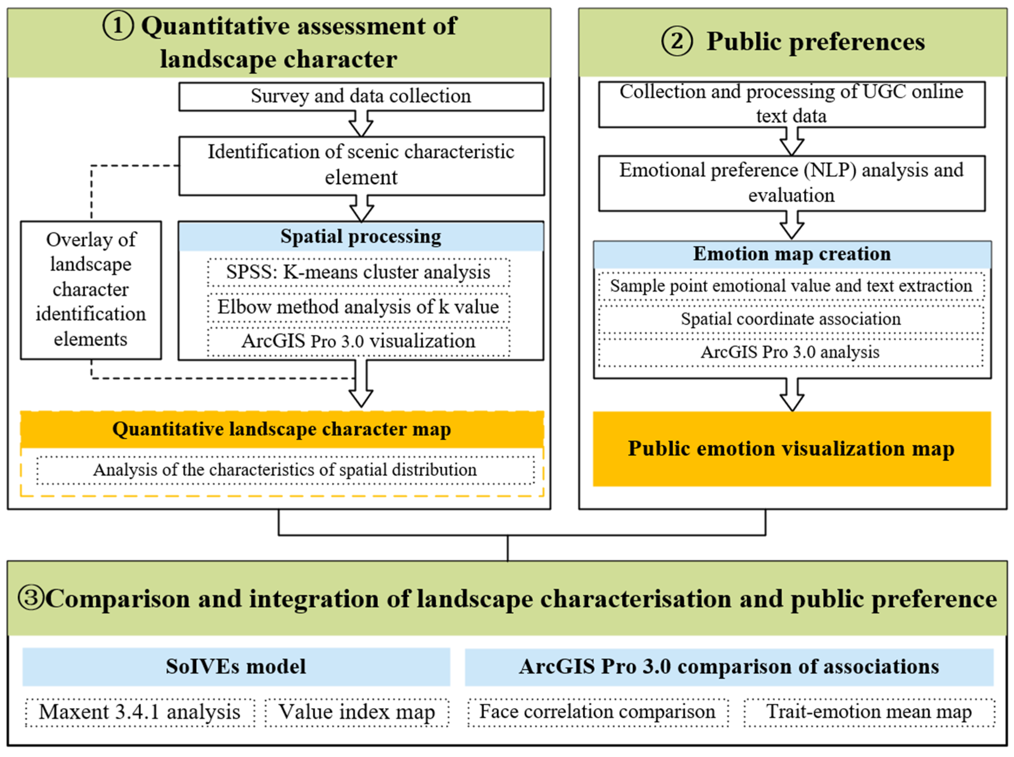
2. Materials and Methods
2.1. Study Area
2.2. Landscape Character Identification
2.3. Public Preference Assessment
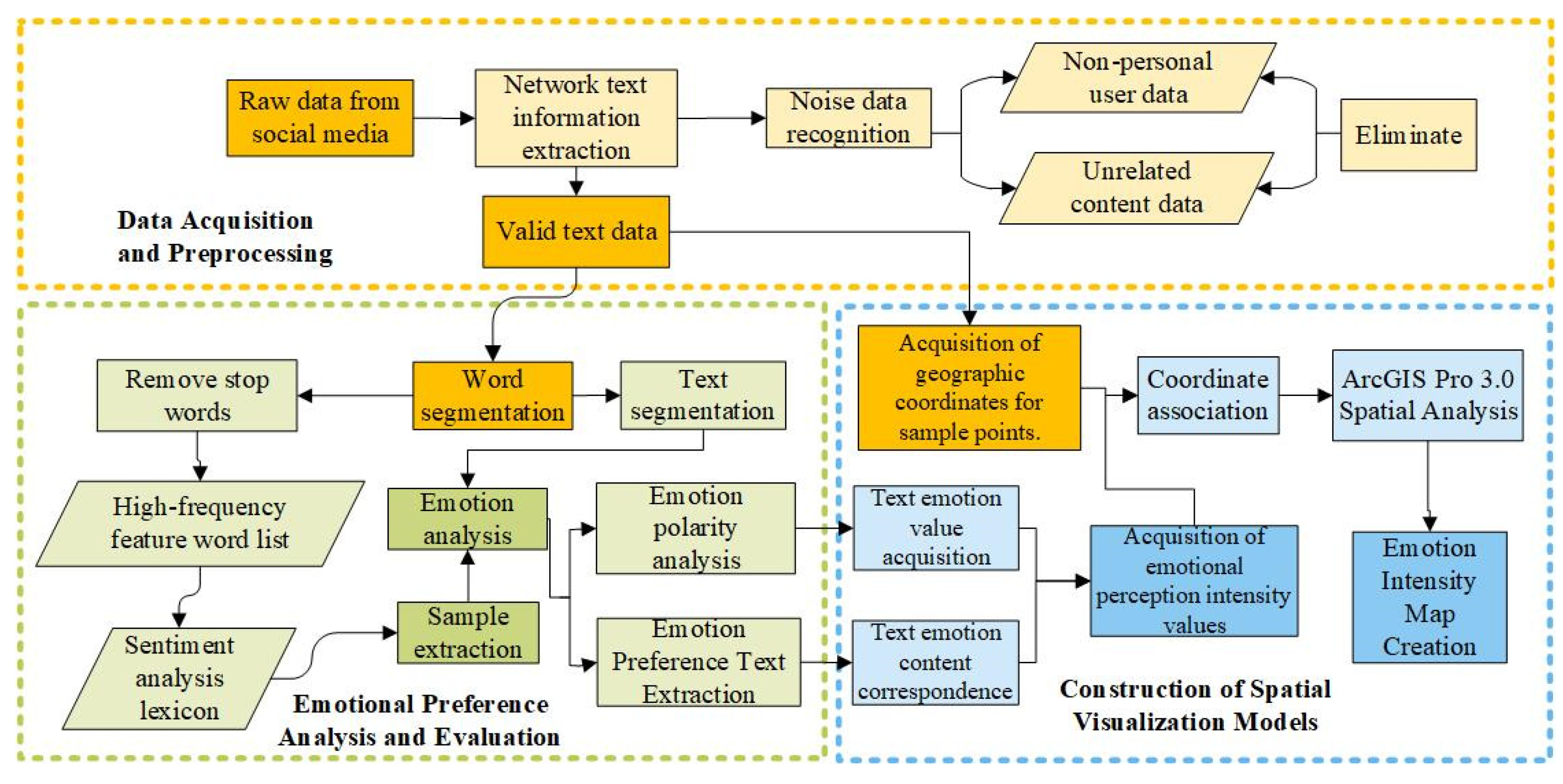
2.3.1. Data Collection and Preprocessing
2.3.2. NLP Emotion Analysis
2.4. Correlation Element Quantitative Analysis
3. Results
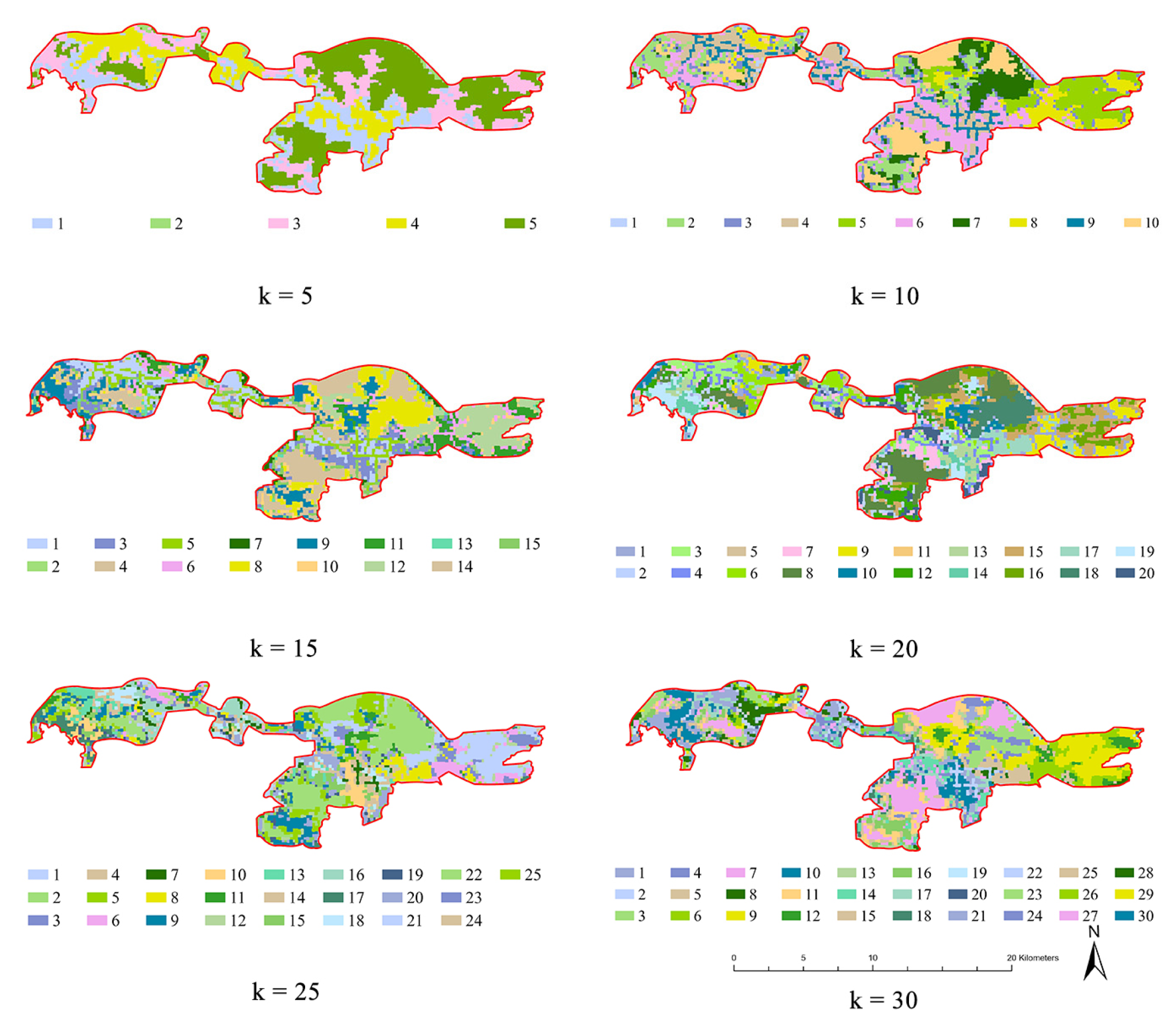
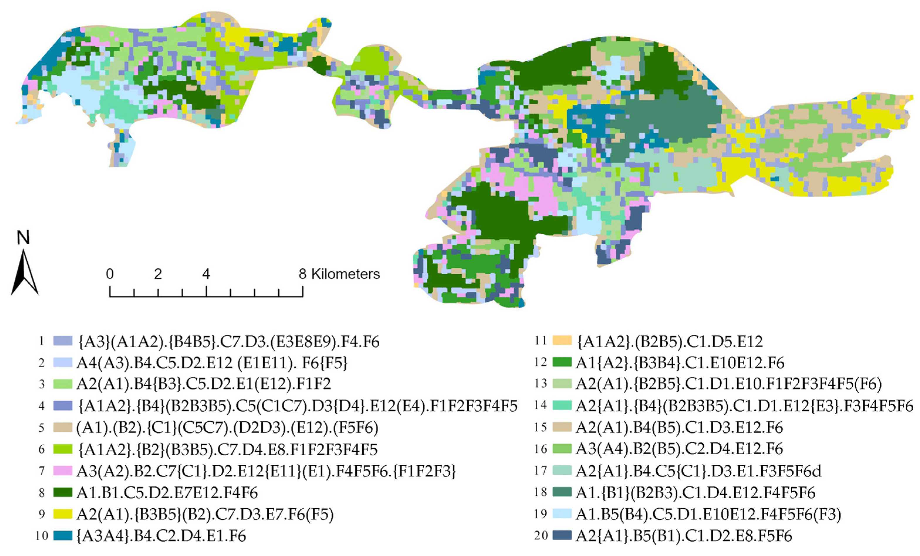
3.1. Landscape Character Identification Results
- (1)
- Natural Terrain-Dominated Types: This group encompasses six distinct landscape types: type 2 characterized by gently sloping farmland areas, type 8 featuring flat water body systems, type 12 representing agroforestry systems on semi-sunny slopes, type 15 consisting of flat farmland expanses, type 16 dominated by woodland ecosystems, and type 18 primarily composed of farmland-dominated terrain. Their spatial distribution is primarily controlled by topographic factors such as slope and aspect, and they generally exhibit a continuous, patch-like distribution pattern. These areas are less affected by urban development pressures and tend to maintain ecological integrity, providing critical ecosystem services such as habitat connectivity and hydrological regulation.
- (2)
- Urban Construction-Driven Types: These landscape types comprise five distinct categories: type 1, characterized by high-density built-up urban areas; type 3, dominated by commercial service areas; type 6, primarily consisting of science and education hubs; type 7, featuring cultural and sports facilities as key elements; and type 13, representing multifunctional residential areas. These types are mainly distributed within urban expansion areas from 2015 to 2020, demonstrating a strong concordance with the phases of city growth. The spatial configuration of these landscapes reflects socio-economic forces and land demand changes associated with urbanization. As cities expand, these areas often experience significant land transformation, increased anthropogenic disturbance, and a reduction in natural surface cover.
- (3)
- Hybrid Transition Types: This category encompasses nine distinct landscape types: type 4 dominated by park green spaces, type 5 featuring a water-residential mixed pattern, type 9 representing built-up areas on semi-shaded slopes, type 10 combining science, education and residential functions, type 11 exhibiting farmland-built-up transitional areas, type 14 characterized by water-farmland mosaics, type 17 integrating water, residential and farmland elements, type 19 blending cultural/sports facilities with green spaces, and type 20 merging science, education and green space components. These types combine both natural and artificial elements, displaying pronounced fragmentation in spatial distribution.
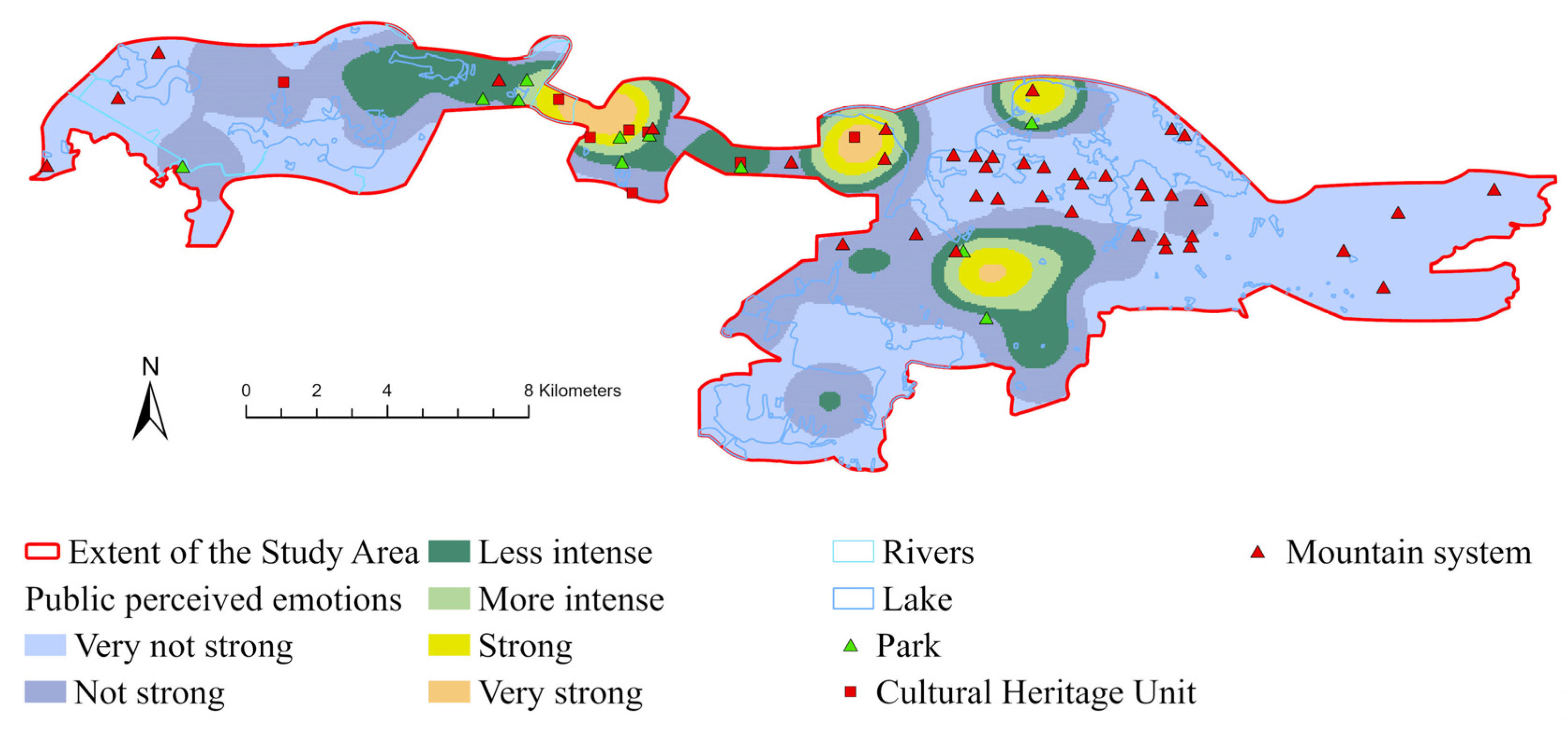
3.2. Public Preferences Results and Visualization
3.3. Relationship Between Landscape Character and Public Preferences
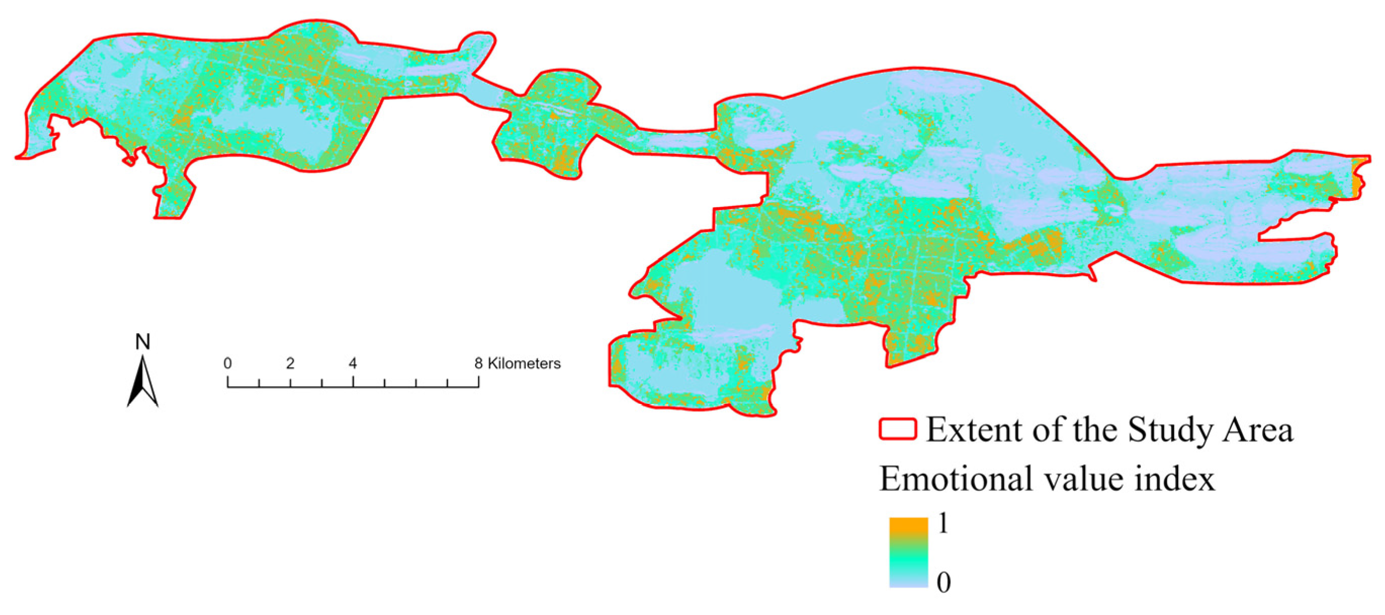
3.3.1. Spatial Analysis of Emotional Value Point Based on the SoIVES Model
3.3.2. Correlation Analysis Between Emotional Value Index and Landscape Character Types
4. Discussion
4.1. Comparison and Integration Between Landscape Characterization and Public Preferences
4.2. Insights on the Landscape Planning and Regulation of the Urban Landscapes in Wuhan
4.3. Limitations and Future Work
5. Conclusions
Author Contributions
Funding
Data Availability Statement
Conflicts of Interest
Appendix A. Multicollinearity Processing and PCA
Appendix A.1. Analysis of VIF

| Variable | VIF | Judgment |
|---|---|---|
| Slope | 1.95455 | Acceptable |
| Aspect | 3.42724 | Acceptable |
| Land Use | 2.90524 | Acceptable |
| Scenic Spot Type | 8.15787 | Acceptable |
| Surface Functionality | 4.79203 | Acceptable |
| Time Depth | 16.8917 | Needs to be addressed |
Appendix A.2. Correlation Test
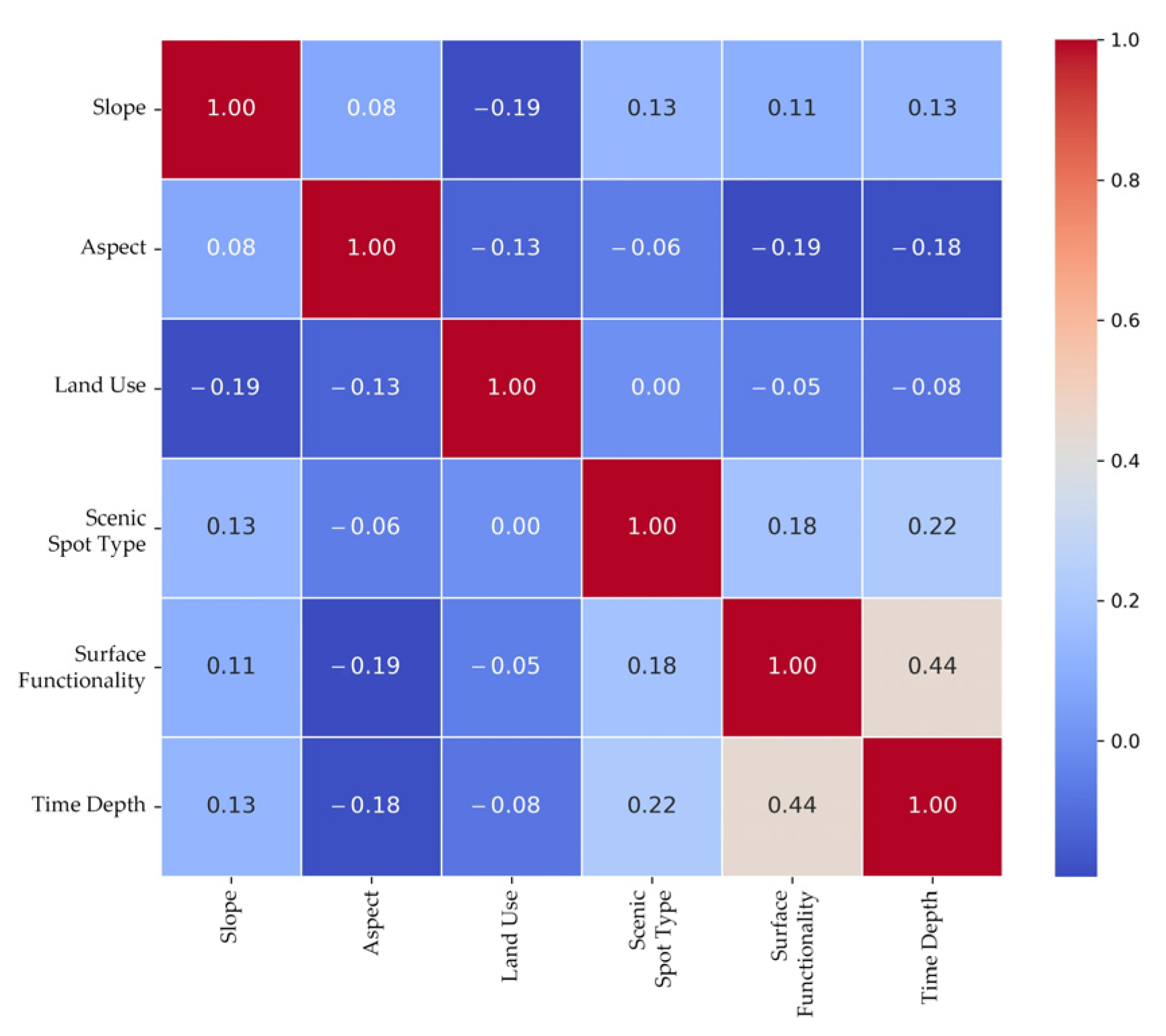
Appendix A.3. Analysis of PCA
| Variable | VIF | Judgment |
|---|---|---|
| Slope | 1.87146 | Acceptable |
| Aspect | 2.904 | Acceptable |
| Land Use | 2.43719 | Acceptable |
| Scenic Spot Type | 4.32232 | Acceptable |
| PCA_Component | 2.54133 | Acceptable |
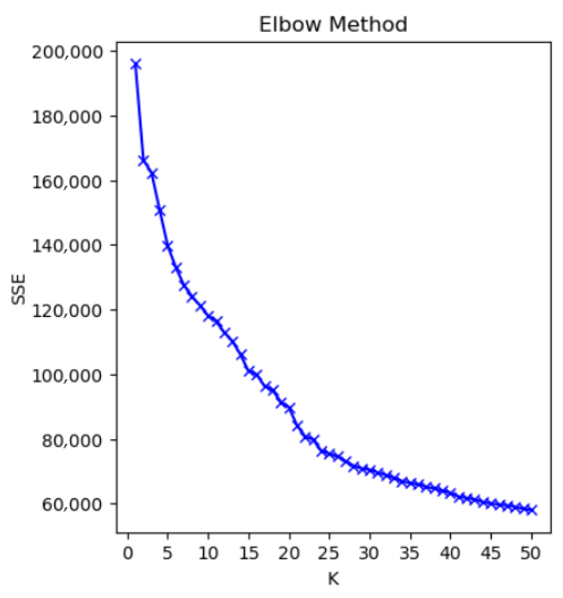
Appendix B. K-Value Determination Using the Elbow Method
References
- Memlük, M.Z. Urban Landscape Design. In Landscape Planning; Ozyavuz, M., Ed.; IntechOpen: Rijeka, Croatia, 2012. [Google Scholar]
- Cadenasso, M.; Pickett, S.T.A. Urban Principles for Ecological Landscape Design and Maintenance: Scientific Fundamentals. Cities Environ. 2008, 1, 4. [Google Scholar] [CrossRef]
- Karimimoshaver, M.; Ahmadi, M.A.; Aram, F.; Mosavi, A. Urban views and their impacts on citizens: A grounded theory study of Sanandaj city. Heliyon 2020, 6, e05157. [Google Scholar] [CrossRef]
- Fan, C.; Myint, S. A comparison of spatial autocorrelation indices and landscape metrics in measuring urban landscape fragmentation. Landsc. Urban Plan. 2014, 121, 117–128. [Google Scholar] [CrossRef]
- Jaeger, J.; Schwarz-von Raumer, H.G.; Esswein, H.; Muller, M.; Schmidt-Luttmann, M. Time Series of Landscape Fragmentation Caused by Transportation Infrastructure and Urban Development: A Case Study from Baden-Wurttemberg, Germany. Ecol. Soc. 2006, 12, 22. [Google Scholar] [CrossRef]
- Liu, Z.; He, C.; Wu, J. The Relationship between Habitat Loss and Fragmentation during Urbanization: An Empirical Evaluation from 16 World Cities. PLoS ONE 2016, 11, e154613. [Google Scholar] [CrossRef] [PubMed]
- Cui, N.; Feng, C.; Wang, D.; Li, J.; Guo, L. The Effects of Rapid Urbanization on Forest Landscape Connectivity in Zhuhai City, China. Sustainability 2018, 10, 3381. [Google Scholar] [CrossRef]
- Li, C.; Wu, Y.; Gao, B.; Zheng, K.; Wu, Y.; Li, C. Multi-scenario simulation of ecosystem service value for optimization of land use in the Sichuan-Yunnan ecological barrier, China. Ecol. Indic. 2021, 132, 108328. [Google Scholar] [CrossRef]
- Song, H.; Cervini, G.; Shreevastava, A.; Jung, J. Reshaping landscape factorization through 3D landscape clustering for urban temperature studies. Sustain. Cities Soc. 2024, 115, 105809. [Google Scholar] [CrossRef]
- Neglia, G.A. Urban Morphology and Forms of the Territory: Between Urban and Landscape Design. Land 2024, 13, 37. [Google Scholar] [CrossRef]
- Bueno-Suárez, C.; Coq-Huelva, D. Sustaining What Is Unsustainable: A Review of Urban Sprawl and Urban Socio-Environmental Policies in North America and Western Europe. Sustainability 2020, 12, 4445. [Google Scholar] [CrossRef]
- He, D.; Chen, W.; Zhang, J. Integrating Heritage and Environment: Characterization of Cultural Landscape in Beijing Great Wall Heritage Area. Land 2024, 13, 536. [Google Scholar] [CrossRef]
- Brabyn, L. Landscape classification using GIS and national digital databases. Landsc. Res. 1996, 21, 277–300. [Google Scholar] [CrossRef]
- Simensen, T.; Halvorsen, R.; Erikstad, L. Methods for landscape characterisation and mapping: A systematic review. Land Use Policy 2018, 75, 557–569. [Google Scholar] [CrossRef]
- Kamičaitytė, J.; Grazuleviciute-Vileniske, I.; Gadal, S. Role of Multicultural Identity in Landscape Perception and Methodological Possibilities of Its Interdisciplinary Analysis. Landsc. Archit. Art 2020, 15, 65–74. [Google Scholar]
- Tara, A.; Lawson, G.; Davies, W.; Chenoweth, A.; Pratten, G. Integrating Landscape Character Assessment with Community Values in a Scenic Evaluation Methodology for Regional Landscape Planning. Land 2024, 13, 169. [Google Scholar] [CrossRef]
- Tudor, C. An Approach to Landscape Character Assessment. Nat. Engl. 2014, 65, 101716. [Google Scholar]
- Atik, M.; Işıklı, R.C.; Ortaçeşme, V. Clusters of landscape characters as a way of communication in characterisation: A study from side, Turkey. J. Environ. Manag. 2016, 182, 385–396. [Google Scholar] [CrossRef]
- Van Eetvelde, V.; Antrop, M. A stepwise multi-scaled landscape typology and characterisation for trans-regional integration, applied on the federal state of Belgium. Landsc. Urban Plan. 2009, 91, 160–170. [Google Scholar] [CrossRef]
- Yang, D.; Gao, C.; Li, L.; Van Eetvelde, V. Multi-scaled identification of landscape character types and areas in Lushan National Park and its fringes, China. Landsc. Urban Plan. 2020, 201, 103844. [Google Scholar] [CrossRef]
- Butler, A.; Sarlöv-Herlin, I. Landscape Character Assessment and Participatory Approaches. In The Routledge Handbook of Landscape Ecology; Routledge: London, UK, 2021. [Google Scholar]
- Tveit, M.; Ode Sang, Å.; Fry, G. Key concepts in a framework for analysing visual landscape character. Landsc. Res.-Landsc. Res. 2006, 31, 229–255. [Google Scholar] [CrossRef]
- Kaltenborn, B.P.; Bjerke, T. Associations between environmental value orientations and landscape preferences. Landsc. Urban Plan. 2002, 59, 1–11. [Google Scholar] [CrossRef]
- Kaplan, R.K.S. The Experience of Nature: A Psychological Perspective; Cambridge University Press: Cambridge, UK, 1989. [Google Scholar]
- Kaplan, R.; Kaplan, S. Well-being, Reasonableness, and the Natural Environment. Appl. Psychol. Health Well-Being 2011, 3, 304–321. [Google Scholar] [CrossRef]
- Marselle, M.R. Theoretical Foundations of Biodiversity and Mental Well-being Relationships. In Biodiversity and Health in the Face of Climate Change; Marselle, M.R., Stadler, J., Korn, H., Irvine, K.N., Bonn, A., Eds.; Springer International Publishing: Cham, Switzerland, 2019; pp. 133–158. [Google Scholar]
- Tveit, M.S. Indicators of visual scale as predictors of landscape preference; a comparison between groups. J. Environ. Manag. 2009, 90, 2882–2888. [Google Scholar] [CrossRef]
- Albaladejo-García, J.A.; Zabala, J.A.; Alcon, F.; Dallimer, M.; Martínez-Paz, J.M. Integrating socio-spatial preference heterogeneity into the assessment of the aesthetic quality of a Mediterranean agricultural landscape. Landsc. Urban Plan. 2023, 239, 104846. [Google Scholar] [CrossRef]
- Brown, G. Relationships between spatial and non-spatial preferences and place-based values in national forests. Appl. Geogr. 2013, 44, 1–11. [Google Scholar] [CrossRef]
- Brown, G. Mapping landscape values and development preferences: A method for tourism and residential development planning. Int. J. Tour. Res. 2006, 8, 101–113. [Google Scholar] [CrossRef]
- Chai-allah, A.; Fox, N.; Brunschwig, G.; Bimonte, S.; Joly, F. A trail-based approach using crowdsourced data to assess recreationists’ preferences for landscape. Landsc. Urban Plan. 2023, 233, 104700. [Google Scholar] [CrossRef]
- Dupont, L.; Antrop, M.; Van Eetvelde, V. Eye-tracking Analysis in Landscape Perception Research: Influence of Photograph Properties and Landscape Characteristics. Landsc. Res. 2014, 39, 417–432. [Google Scholar] [CrossRef]
- Saldias, D.S.M.; Reinke, K.; Mclennan, B.; Wallace, L. The influence of satellite imagery on landscape perception. Landsc. Res. 2021, 46, 749–765. [Google Scholar] [CrossRef]
- Kong, I.; Sarmiento, F.O.; Mu, L. Crowdsourced text analysis to characterize the U.S. National Parks based on cultural ecosystem services. Landsc. Urban Plan. 2023, 233, 104692. [Google Scholar] [CrossRef]
- Zhang, H.; Huang, R.; Zhang, Y.; Buhalis, D. Cultural ecosystem services evaluation using geolocated social media data: A review. Tour. Geogr. 2022, 24, 646–668. [Google Scholar] [CrossRef]
- Egarter Vigl, L.; Marsoner, T.; Giombini, V.; Pecher, C.; Simion, H.; Stemle, E.; Tasser, E.; Depellegrin, D. Harnessing artificial intelligence technology and social media data to support Cultural Ecosystem Service assessments. People Nat. 2021, 3, 673–685. [Google Scholar] [CrossRef]
- Komossa, F.; Mariño, D.; Michel, A.H.; Purves, R.S. Find the one you like! Profiling Swiss parks with user generated content. J. Outdoor Recreat. Tour. 2023, 44, 100673. [Google Scholar] [CrossRef]
- Kong, I.; Sarmiento, F.O. Utilizing a crowdsourced phrasal lexicon to identify cultural ecosystem services in El Cajas National Park, Ecuador. Ecosyst. Serv. 2022, 56, 101441. [Google Scholar] [CrossRef]
- Kong, L.; Liu, Z.; Pan, X.; Wang, Y.; Guo, X.; Wu, J. How do different types and landscape attributes of urban parks affect visitors’ positive emotions? Landsc. Urban Plan. 2022, 226, 104482. [Google Scholar] [CrossRef]
- Liu, W.; Hu, X.; Song, Z.; Yuan, X. Identifying the integrated visual characteristics of greenway landscape: A focus on human perception. Sustain. Cities Soc. 2023, 99, 104937. [Google Scholar] [CrossRef]
- Wang, Y.; Yang, D.; Lu, Y.; Gao, C. A character-based conceptual framework to integrate landscape services into landscape planning. Landscape Res. 2025, 1–17. [Google Scholar] [CrossRef]
- Brown, G.; Brabyn, L. An analysis of the relationships between multiple values and physical landscapes at a regional scale using public participation GIS and landscape character classification. Landsc. Urban Plan. 2012, 107, 317–331. [Google Scholar] [CrossRef]
- Dramstad, W.E.; Tveit, M.S.; Fjellstad, W.J.; Fry, G.L.A. Relationships between visual landscape preferences and map-based indicators of landscape structure. Landsc. Urban Plan. 2006, 78, 465–474. [Google Scholar] [CrossRef]
- Katja, S.; Ariane, W.; Isobel, J.; Marc, J.M. The Sociocultural Value of Upland Regions in the Vicinity of Cities in Comparison With Urban Green Spaces. Mt. Res. Dev. 2016, 36, 465–474. [Google Scholar]
- Xiong, H.; Hu, H.; Han, P.; Wang, M. Integrating Landscape Ecological Risks and Ecosystem Service Values into the Ecological Security Pattern Identification of Wuhan Urban Agglomeration. Int. J. Environ. Res. Public Health 2023, 20, 2792. [Google Scholar] [CrossRef]
- Sun, Z.; Xue, W.; Kang, D.; Peng, Z. Assessment of Ecosystem Service Values of Urban Wetland: Taking East Lake Scenic Area in Wuhan as an Example. Land 2024, 13, 1013. [Google Scholar] [CrossRef]
- Ode, Å.; Fry, G.; Tveit, M.S.; Messager, P.; Miller, D. Indicators of perceived naturalness as drivers of landscape preference. J. Environ. Manag. 2009, 90, 375–383. [Google Scholar] [CrossRef]
- Ravi, K.; Ravi, V. A survey on opinion mining and sentiment analysis: Tasks, approaches and applications. Knowl.-Based Syst. 2015, 89, 14–46. [Google Scholar] [CrossRef]
- Petrakis, R.; Norman, L.; Lysaght, O.; Sherrouse, B.; Semmens, D.; Bagstad, K.; Pritzlaff, R. Mapping Perceived Social Values to Support a Respondent-Defined Restoration Economy: Case Study in Southeastern Arizona, USA. Air Soil Water Res. 2020, 13, 280445501. [Google Scholar] [CrossRef]
- Sherrouse, B.C.; Semmens, D.J. Social Values for Ecosystem Services (SoIVES): Using GIS to include social values information in ecosystem services assessments. In Fact Sheet; US Geological Survey: Reston, VA, USA, 2010. [Google Scholar]
- Yang, C.; Li, R.; Sha, Z. Exploring the Dynamics of Urban Greenness Space and Their Driving Factors Using Geographically Weighted Regression: A Case Study in Wuhan Metropolis, China. Land 2020, 9, 500. [Google Scholar] [CrossRef]
- Campo-Bescós, M.A.; Muñoz-Carpena, R.; Southworth, J.; Zhu, L.; Waylen, P.R.; Bunting, E. Combined Spatial and Temporal Effects of Environmental Controls on Long-Term Monthly NDVI in the Southern Africa Savanna. Remote Sens. 2013, 5, 6513–6538. [Google Scholar] [CrossRef]
- Chen, B.; Lu, Y.; Imran, M.; Adam, N.A.; Jang, J. Evaluating and transferring social value of ecosystem services in urban wetland parks using the SoIVES model. Ecol. Indic. 2025, 172, 113270. [Google Scholar] [CrossRef]
- Celebi, M.E.; Kingravi, H.A.; Vela, P.A. A comparative study of efficient initialization methods for the k-means clustering algorithm. Expert Syst. Appl. 2013, 40, 200–210. [Google Scholar] [CrossRef]
- Zu, X.; Gao, C.; Wang, Y. Interpreting regional characteristics of Tibetan-Qiang houses in Northwestern Sichuan by Deep Learning and Image Landscape. Int. J. Appl. Earth Obs. 2024, 129, 103865. [Google Scholar] [CrossRef]
- Morissette, L.; Chartier, S. The k-means clustering technique: General considerations and implementation in Mathematica. Tutor. Quant. Methods Psychol. 2013, 9, 15–24. [Google Scholar] [CrossRef]
- Dang, Y.; Zhao, Z.; Kong, X.; Lei, M.; Liao, Y.; Xie, Z.; Song, W. Discerning the process of cultivated land governance transition in China since the reform and opening-up-- Based on the multiple streams framework. Land Use Policy 2023, 133, 106844. [Google Scholar] [CrossRef]
- Zhao, Y.; Huang, X.; Zhao, Y.; Liu, X.; Zhou, R. The application of landscape character classification for spatial zoning management in mountainous protected areas—A case study of Laoshan national park, China. Heliyon 2023, 9, e13996. [Google Scholar] [CrossRef] [PubMed]
- Arias-García, J.; Gómez-Zotano, J.; Delgado, J. Classifying landscape in endorheic basins: A methodological approach for the implementation of the european landscape convention. Eur. J. Geogr. 2017, 8, 55–77. [Google Scholar]
- Mercadé-Aloy, J.; Cervera-Alonso-de-Medina, M. Enhancing Access to Urban Hill Parks: The Montjuïc Trail Masterplan and the 360° Route Design in Barcelona. Land 2024, 13, 2. [Google Scholar] [CrossRef]
- Lu, Y.; Xu, S.; Liu, S.; Wu, J. An approach to urban landscape character assessment: Linking urban big data and machine learning. Sustain. Cities Soc. 2022, 83, 103983. [Google Scholar] [CrossRef]
- Xu, J.; Hu, L. Geospatial Semantics Analysis of the Qinghai–Tibetan Plateau Based on Microblog Short Texts. ISPRS Int. J. Geo-Inf. 2021, 10, 682. [Google Scholar] [CrossRef]
- Hobel, H.; Fogliaroni, P. Extracting Semantics of Places from User Generated Content. In Proceedings of the 19th AGILE International Conference on Geographic Information Science, Helsinki, Finland, 14–17 June 2016. [Google Scholar]
- Middleton, S.E.; Krivcovs, V. Geoparsing and Geosemantics for Social Media: Spatiotemporal Grounding of Content Propagating Rumors to Support Trust and Veracity Analysis during Breaking News. ACM Trans. Inform. Syst. 2016, 34, 16. [Google Scholar] [CrossRef]
- Sherrouse, B.C.; Semmens, D.J. Social Values for Ecosystem Services, version 4.0 (SoIVES 4.0)—Documentation and user manual. In Techniques and Methods; US Geological Survey: Reston, VA, USA, 2020. [Google Scholar]
- Sherrouse, B.C.; Semmens, D.J.; Ancona, Z.H. Social Values for Ecosystem Services (SoIVES): Open-source spatial modeling of cultural services. Environ. Model. Softw. 2022, 148, 105259. [Google Scholar] [CrossRef]
- Greene, M.; Baldassano, C.; Esteva, A.; Beck, D.; Fei-Fei, L. Visual Scenes Are Categorized by Function. J. Exp. Psychol. Gen. 2016, 145, 82–94. [Google Scholar] [CrossRef]
- Hermes, J.; Albert, C.; von Haaren, C. Assessing the aesthetic quality of landscapes in Germany. Ecosyst. Serv. 2018, 31, 296–307. [Google Scholar] [CrossRef]
- Kalinauskas, M.; Mikša, K.; Inácio, M.; Gomes, E.; Pereira, P. Mapping and assessment of landscape aesthetic quality in Lithuania. J. Environ. Manag. 2021, 286, 112239. [Google Scholar] [CrossRef] [PubMed]
- Daniel, T.C. Whither scenic beauty? Visual landscape quality assessment in the 21st century. Landsc. Urban Plan. 2001, 54, 267–281. [Google Scholar] [CrossRef]
- Russo, A.; Cirella, G.T. Urban Ecosystem Services: Advancements in Urban Green Development. Land 2023, 12, 522. [Google Scholar] [CrossRef]
- Sun, W.; Liu, C.G.; Wang, S.N. Simulation research of urban development boundary based on ecological constraints: A case study of Nanjing. J. Nat. Resour. 2021, 36, 2913–2925. [Google Scholar] [CrossRef]
- Andersson-Sköld, Y.; Klingberg, J.; Gunnarsson, B.; Cullinane, K.; Gustafsson, I.; Hedblom, M.; Knez, I.; Lindberg, F.; Ode Sang, Å.; Pleijel, H.; et al. A framework for assessing urban greenery’s effects and valuing its ecosystem services. J. Environ. Manag. 2018, 205, 274–285. [Google Scholar] [CrossRef]
- Luo, T. Ecological Restoration of the West Lake in Hangzhou, China. Int. Rev. Spat. Plan. Sustain. Dev. 2019, 7, 31–49. [Google Scholar] [CrossRef]
- Wang, D.; Li, S. Innovation of Contemporary Chinese Urban Community Governance under the Perspective of Social Capital: Participation of Multiple Subjects Based on Community Proposals. Sustainability 2023, 15, 93. [Google Scholar] [CrossRef]
- Huang, Y.; Li, Z.; Huang, Y. User Perception of Public Parks: A Pilot Study Integrating Spatial Social Media Data with Park Management in the City of Chicago. Land 2022, 11, 211. [Google Scholar] [CrossRef]
- Zoderer, B.M.; Carver, S.; Tappeiner, U.; Tasser, E. Ordering ‘wilderness’: Variations in public representations of wilderness and their spatial distributions. Landsc. Urban Plan. 2020, 202, 103875. [Google Scholar] [CrossRef]
- Li, X.; Huang, K.; Zhang, R.; Chen, Y.; Dong, Y. Visual Perception Optimization of Residential Landscape Spaces in Cold Regions Using Virtual Reality and Machine Learning. Land 2024, 13, 367. [Google Scholar] [CrossRef]
- Liang, X.; Hexin, J.; Xu, W.; Zhou, Y. Gaussian-Smoothed Imbalance Data Improves Speech Emotion Recognition. arXiv 2023, arXiv:2302.08650. [Google Scholar]
- Stark, P.; Hasenbein, L.; Kasneci, E.; Göllner, R. Gaze-based attention network analysis in a virtual reality classroom. Methodsx 2024, 12, 102662. [Google Scholar] [CrossRef] [PubMed]
- Clay, V.; König, P.; König, S. Eye Tracking in Virtual Reality. J. Eye Mov. Res. 2019, 12, 1–18. [Google Scholar] [CrossRef]
- Wan, C.; Shen, G.Q.; Choi, S. Eliciting users’ preferences and values in urban parks: Evidence from analyzing social media data from Hong Kong. Urban For. Urban Green. 2021, 62, 127172. [Google Scholar] [CrossRef]
- Devika, M.D.; Sunitha, C.; Ganesh, A. Sentiment Analysis: A Comparative Study on Different Approaches. Procedia Comput. Sci. 2016, 87, 44–49. [Google Scholar] [CrossRef]
- Tabachnick, B.G.; Fidell, L.S. Using Multivariate Statistics, 5th ed.; Allyn & Bacon/Pearson Education: Boston, MA, USA, 2007; p. 980. [Google Scholar]
- Kaiser, H.F. An index of factorial simplicity. Psychometrika 1974, 39, 31–36. [Google Scholar] [CrossRef]


| Level Indicators | Elements | Code |
|---|---|---|
| Slope A | Flat Slope ≤ 2° | A1 |
| Gentle Slope (2–6°] | A2 | |
| Moderately gentle Slope (6–15°] | A3 | |
| Moderately steep Slope (15–25°] | A4 | |
| Steep Slope > 25° | A5 | |
| Aspect B | No Aspect (−1°) | B1 |
| Shady Slope (0–45°, 315–360°) | B2 | |
| Semi-Shady Slope (45–135°) | B3 | |
| Sunny Slope (135–225°) | B4 | |
| Semi-Sunny Slope (225–315°) | B5 | |
| Land Use C | Farmland | C1 |
| Forest | C2 | |
| Shrubland | C3 | |
| Grassland | C4 | |
| Water Body | C5 | |
| Unused Land | C6 | |
| Urban Construction Land | C7 | |
| Scenic Spot Type D | 3A-Level Scenic area | D1 |
| 4A-Level Scenic area | D2 | |
| 5A-Level Scenic area | D3 | |
| Cultural Relics Protection Units | D4 | |
| Park | D5 | |
| Surface Functionality E | Residential Land | E1 |
| Commercial Office Land | E2 | |
| Commercial Service Land | E3 | |
| Industrial Land | E4 | |
| Transportation Hub Land | E5 | |
| Airport Facility Land | E6 | |
| Administrative Office Land | E7 | |
| Educational and Research Land | E8 | |
| Medical and Health Land | E9 | |
| Sports and Cultural Land | E10 | |
| Park and Green Space Land | E11 | |
| Non-Construction Land | E12 | |
| Time Depth F | Urban Coverage Before 1990 | F1 |
| Urban Coverage Before 2000 | F2 | |
| Urban Coverage Before 2010 | F3 | |
| Urban Coverage Before 2015 | F4 | |
| Urban Coverage Before 2020 | F5 | |
| Non-Built-Up area | F6 |
| Landscape Characters | Encodings | Key Natural Elements | Key Cultural Elements |
|---|---|---|---|
| 1 | {A3}(A1A2). {B4B5}. C7. D3. (E3E8E9). F4. F6 | moderately gentle slope, flat slope, gentle slope terrain; sunny slope, semi-sunny slope terrain; predominantly urban construction land; with small amounts of commercial service, educational and research, medical and health land; mostly located within the 2015 urban coverage region, non-built-up areas also distributed | 5A-class tourist attraction |
| 2 | A4(A3). B4. C5. D2. E12 (E1E11). F6{F5} | moderately steep slope, moderately gentle slope terrain; sunny slope terrain; large water body region; mostly in non-construction land, with residential land, park and green space land; mostly in non-built-up area, partly located within the 2020 urban coverage area | 4A-class tourist attraction |
| 3 | A2(A1). B4{B3}. C5. D2. E1(E12). F1F2 | gentle slope, flat slope terrain; sunny slope, semi-shady slope terrain; predominantly water body area; large proportion of residential land and non-construction land; covering 1990–2020 stages of urban coverage area | 4A-class tourist attraction |
| 4 | {A1A2}. {B4}(B2B3B5). C5(C1C7). D3{D4}. E12(E4). F1F2F3F4F5 | flat slope, gentle slope; sunny slope terrain; mostly sunny slope, with shady slope, semi-shady slope and semi-sunny slope terrain; water body, farmland and urban construction land coexist; predominantly non-construction land and industrial land; covering 1990–2020 stages of urban coverage area | 5A-class tourist attraction, major historical and cultural sites |
| 5 | (A1). (B2). {C1}(C5C7). (D2D3). (E12). (F5F6) | flat slope terrain; shady slope terrain; farmland, water body and urban construction land coexist; predominantly non-construction land; covering 2020 stages of urban coverage area and non-built-up area | 4A and 5A-class tourist attraction |
| 6 | {A1A2}. {B2}(B3B5). C7. D4. E8. F1F2F3F4F5 | flat slope, gentle slope terrain; mostly shady slope, with semi-shady slope and semi-sunny slope terrain; predominately urban construction land, with educational and research land; covering 1990–2020 stages of urban coverage area | Major historical and cultural sites |
| 7 | A3(A2). B2. C7{C1}. D2. E12{E11}(E1). F4F5F6. {F1F2F3} | moderately gentle slope, gentle slope terrain; shady slope terrain; predominately urban construction land and farmland; non-construction land, park and green space land, residential land are predominant; mostly located in the 2015–2020 urban coverage region, partly located in the 1990–2010 urban coverage area | 4A-class tourist attraction |
| 8 | A1. B1. C5. D2. E7E12. F4F6 | flat slope terrain; no aspect terrain; predominately water body; administrative office, non-construction land are predominant; mostly located within the 2015 urban coverage region, partly located in non-built-up area | 4A-class tourist attraction |
| 9 | A2(A1). {B3B5}(B2). C7. D3. E7. F6(F5) | gentle slope, flat slope terrain; semi-shady slope, semi-sunny slope, shady slope terrain; predominately urban construction land; administrative office land is dominant; mostly located in non-built-up area, partly located within the 2020 urban coverage area | 5A-class tourist attraction |
| 10 | {A3A4}. B4. C2. D4. E1. F6 | moderately gentle slope, moderately steep slope terrain; sunny slope terrain; predominately forest; residential land is dominant; mostly located in non-built-up area | Major historical and cultural sites |
| 11 | {A1A2}. (B2B5). C1. D5. E12 | flat slope, gentle slope terrain; shady slope, semi-sunny slope terrain; predominately farmland; mostly located in non-built-up area. | Park (for public recreation) |
| 12 | A1{A2}. {B3B4}. C1. E10E12. F6 | flat slope, gentle slope terrain; semi-shady slope, sunny slope terrain; predominately farmland; sports and cultural, non-construction land predominates; mostly located in non-built-up area | - |
| 13 | A2(A1). {B2B5}. C1. D1. E10. F1F2F3F4F5(F6) | gentle slope, flat slope terrain; shady slope, semi-sunny slope terrain; predominately farmland; sports and cultural land dominated; covering 1990–2020 stages of urban coverage area, partly in non-built-up area | 3A-class tourist attraction |
| 14 | A2{A1}. {B4}(B2B3B5). C1. D1. E12{E3}. F3F4F5F6 | gentle slope, flat slope; sunny slope terrain; mostly sunny slope, with shady slope, semi-shady slope and semi-sunny slope terrain; predominately farmland; non-construction land, commercial service land are dominant; covering the 2010–2020 stages of urban coverage area | 3A-class tourist attraction |
| 15 | A2(A1). B4(B5). C1. D3. E12. F6 | gentle slope, flat slope terrain; sunny slope, semi-sunny slope terrain; predominately farmland; non-construction land is dominant; mostly in non-built-up area | 5A-class tourist attraction |
| 16 | A3(A4). B2(B5). C2. D4. E12. F6 | moderately gentle slope, moderately steep slope terrain; shady slope, semi-sunny slope terrain; predominately forest; non-construction land is dominant; mostly in non-built-up area | Major historical and cultural sites |
| 17 | A2{A1}. B4. C5{C1}. D3. E1. F3F5F6 | gentle slope, flat slope terrain; sunny slope terrain; predominately water body, farmland; residential land is dominant; covering 2010–2020 stages of urban coverage region and non-built-up area | 5A-class tourist attraction |
| 18 | A1. {B1}(B2B3). C1. D4. E12. F4F5F6 | flat slope terrain; sunny slope terrain; mostly no aspect, with shady slope and semi-shady slope terrain; predominately farmland; non-construction land is dominant; covering 2015–2020 stages of urban coverage region and non-built-up area | Major historical and cultural sites |
| 19 | A1. B5(B4). C5. D1. E10E12. F4F5F6(F3) | flat slope terrain, semi-sunny slope, sunny slope terrain; predominately water body; sports and cultural, non-construction land are dominant; covering 2015–2020 stages of urban coverage area, partly located within the 2010 urban coverage area | 3A-class tourist attraction |
| 20 | A2{A1}. B5(B1). C1. D2. E8. F5F6 | gentle slope, flat slope terrain; semi-sunny slope, no aspect terrain; predominately farmland; educational and research land is dominant; located within the 2020 urban coverage area and non-built-up area | 4A-class tourist attraction |
Disclaimer/Publisher’s Note: The statements, opinions and data contained in all publications are solely those of the individual author(s) and contributor(s) and not of MDPI and/or the editor(s). MDPI and/or the editor(s) disclaim responsibility for any injury to people or property resulting from any ideas, methods, instructions or products referred to in the content. |
© 2025 by the authors. Licensee MDPI, Basel, Switzerland. This article is an open access article distributed under the terms and conditions of the Creative Commons Attribution (CC BY) license (https://creativecommons.org/licenses/by/4.0/).
Share and Cite
Li, X.; Pang, W.; Han, L.; Yan, Y.; Pan, X.; Yang, D. Relationship Between Landscape Character and Public Preferences in Urban Landscapes: A Case Study from the East–West Mountain Region in Wuhan, China. Land 2025, 14, 1228. https://doi.org/10.3390/land14061228
Li X, Pang W, Han L, Yan Y, Pan X, Yang D. Relationship Between Landscape Character and Public Preferences in Urban Landscapes: A Case Study from the East–West Mountain Region in Wuhan, China. Land. 2025; 14(6):1228. https://doi.org/10.3390/land14061228
Chicago/Turabian StyleLi, Xingyuan, Wenqing Pang, Lizhi Han, Yufan Yan, Xianjie Pan, and Diechuan Yang. 2025. "Relationship Between Landscape Character and Public Preferences in Urban Landscapes: A Case Study from the East–West Mountain Region in Wuhan, China" Land 14, no. 6: 1228. https://doi.org/10.3390/land14061228
APA StyleLi, X., Pang, W., Han, L., Yan, Y., Pan, X., & Yang, D. (2025). Relationship Between Landscape Character and Public Preferences in Urban Landscapes: A Case Study from the East–West Mountain Region in Wuhan, China. Land, 14(6), 1228. https://doi.org/10.3390/land14061228