Review

Monitoring Slope Stability: A Comprehensive Review of UAV Applications in Open-Pit Mining

by
Stephanos Tsachouridis
1,
Francis Pavloudakis
1,*,
Constantinos Sachpazis
1 and
Vassilios Tsioukas
2
1
Department of Mineral Resources Engineering, Faculty of Engineering, University of Western Macedonia, 50150 Kozani, Greece
2
School of Rural and Surveying Engineering, Faculty of Engineering, Aristotle University of Thessaloniki, 54124 Thessaloniki, Greece
*
Author to whom correspondence should be addressed.
Land 2025, 14(6), 1193; https://doi.org/10.3390/land14061193
Submission received: 31 March 2025 / Revised: 28 May 2025 / Accepted: 30 May 2025 / Published: 3 June 2025
(This article belongs to the Section Land – Observation and Monitoring)

Abstract

:
Unmanned aerial vehicles (UAVs) have increasingly proven to be flexible tools for mapping mine terrain, offering expedient and precise data compared to alternatives. Photogrammetric outputs are particularly beneficial in open pit operations and waste dump areas, since they enable cost-effective and reproducible digital terrain models. Meanwhile, UAV-based LiDAR has proven invaluable in situations where uniform ground surfaces, dense vegetation, or steep slopes challenge purely photogrammetric solutions. Recent advances in machine learning and deep learning have further enhanced the capacity to distinguish critical features, such as vegetation and fractured rock surfaces, thereby reducing the likelihood of accidents and ecological damage. Nevertheless, scientific gaps remain to be researched. Standardization around flight practices, sensor selection, and data verification persists as elusive, and most mining sites still rely on limited, multi-temporal surveys that may not capture sudden changes in slope conditions. Complexity lies in devising strategies for rehabilitated dumps, where post-mining restoration efforts involve vegetation regrowth, erosion mitigation, and altered land use. Through expanded sensor integration and refined automated analysis, approaches could shift from information gathering to ongoing hazard assessment and environmental surveillance. This evolution would improve both safety and environmental stewardship, reflecting the emerging role of UAVs in advancing a more sustainable future for mining.

1. Introduction

Mining industries worldwide rely heavily on open-pit extraction to access valuable mineral resources and meet growing economic demands. However, the physical excavation of large volumes of rock and overburden results in steep pit slopes that can be susceptible to instabilities, posing significant risks to human safety, mine continuity, and environmental sustainability [1,2,3,4,5]. In particular, unexpected slope failures in active mines have long been recognized as one of the most hazardous events [6,7,8,9]. Consequently, improving the accuracy and efficiency of slope stability assessments has become a top priority within the geotechnical field, leading to the growing adoption of Unmanned Aerial Vehicles (UAVs) as a monitoring tool over the last decade (2014–2024) [7,10,11,12,13]. This review is the first to synthesize a decade of global literature on UAV-based displacement monitoring in open-pit mines while systematically exposing methodological gaps and charting a roadmap toward fully integrated, real-time slope-stability frameworks.

1.1. The Role of UAVs in Contemporary Mining

Remote sensing using satellite imagery, total stations, extensometers, and slope stability radars has been a staple approach for monitoring ground displacement in mines [14,15,16]. However, these legacy systems can be limited by spatial coverage, cost, or practical constraints, such as the need to install equipment in risky or inaccessible regions [3,6,7]. In addition, they could often prove expensive or cumbersome for large sites [13,17]. In response, UAV-based photogrammetry and LiDAR scanning have emerged as cost-effective and flexible alternatives [3,6,8].
Beyond simple static surveys, repeated UAV flights conducted weekly or monthly facilitate time-series analyses of slope displacement [12,18,19]. Data processing workflows (e.g., structure-from-motion algorithms and point-cloud differencing) can detect sub-meter or even centimeter-scale changes in slope geometry, offering early warnings that allow mine operators to intervene before catastrophic collapses occur [5,12,18]. Moreover, UAVs can gather spatially dense measurements, enhancing the resolution of hazard maps and supporting robust risk assessments that inform drill-and-blast schedules, bench design, and operational safety protocols [1,7] by accessing steep and hazardous areas [20,21,22].

1.2. Multidisciplinary Integration for UAV-Based Slope Stability Research

The effective use of UAVs in slope stability research depends on interdisciplinary collaboration among several scientific domains. First, geotechnical engineering supplies the theoretical foundation for understanding slope processes, failure mechanisms, and material behavior under load. Next, remote sensing and photogrammetry form the technical backbone for data acquisition and image-processing workflows, ensuring that geometric information about slopes is gathered accurately and at high resolution. In parallel, computer science and machine learning enable automated data handling, object recognition, and predictive modeling, transforming dense point clouds or image sets into actionable insights. Moreover, geophysics and hydrology often contribute valuable supplemental information, such as subsurface properties or water flow paths, that can influence slope stability. Finally, environmental science is essential for placing mining operations within broader sustainability and reclamation goals, emphasizing land-use planning, erosion control, and biodiversity considerations.
By integrating these scientific disciplines, UAV-based approaches can evolve from isolated mapping tasks into comprehensive frameworks that incorporate rock mechanics, geotechnical constraints, hazard forecasting, and ecological impacts. Such synergy ensures that each stage of data collection and interpretation, ranging from flight planning and sensor calibration to numerical slope modeling and reclamation monitoring, draws on the right mix of expertise. Ultimately, this interdisciplinary perspective positions UAV-based slope stability research as a powerful means to reconcile economic extraction with safer, more sustainable long-term land management.

1.3. The Ultimate Scope of UAV-Based Ground Displacement Monitoring

Ensuring human safety remains a primary rationale for UAV-based slope stability research. Open-pit mines are prone to rockfalls and landslides, which, if overlooked, can threaten human lives and disrupt mining operations [4,7,10]. UAV surveys, capable of detecting and characterizing incipient failure zones (e.g., tension cracks), thereby offer critical early-warning data. This not only reduces the risk of costly equipment damage and operational downtime but also bolsters organizational efficiency through proactive hazard mitigation. Moreover, in the broader context of mine transition, recent approaches emphasize not just traditional reclamation or rehabilitation but also repurposing and co-purposing of former mining sites, intending to address social and economic challenges linked to mine closures [7,13]. Effective UAV monitoring contributes significantly to these strategies by providing high-resolution topographic data that guides the selection of appropriate post-mining land uses, incorporating environmental, social, and economic considerations. Through such integrated approaches, mining companies can optimize site conditions for long-term stability and more sustainable land utilization after resource extraction. By providing near-real-time insights into slope health, mines can preserve worker safety, optimize excavation strategies, and plan effective reclamation activities that sustain the land’s integrity over the full lifecycle of the pit.

1.4. Research Trends (2014–2024) and Industry Benefits

Over the past decade (2014–2024), UAV-based slope stability research in open-pit mining has evolved from small-scale pilots into comprehensive monitoring solutions that directly benefit mine operations [13,23,24]. UAV surveys became more robust and repeatable [23,24], allowing mine operators to detect subtle displacement patterns, identify rock fractures, and pinpoint moisture infiltration zones that can lead to unexpected failures [9,13,18,25]. By capturing such early indicators, management can implement targeted stabilization measures that avoid costly production downtimes and repair bills [13,22]. UAVs have also delivered faster turnaround times for data collection and analysis, making it possible to conduct slope stability assessments on demand, for instance, after heavy rainfalls or blasting operations [17,26]. Moreover, regulatory acceptance of UAV-derived data has grown, enabling operators to integrate these methods into their safety protocols without duplicating efforts with traditional geodetic or radar systems [4,13,27,28]. Beyond day-to-day operations, high-resolution UAV imagery supports longer-term planning by revealing how slope conditions evolve over multiple months or seasons, enhancing post-event forensics and shaping proactive maintenance schedules [18,22].

1.5. Gaps in the Literature

Despite substantial progress, several research gaps persist and warrant focused attention:
  • Standardized Methodologies: Current studies employ diverse workflows for flight planning, camera calibration, and data processing, making it difficult to compare outcomes across different mine sites [4,29,30]. Developing consistent, validated protocols—from determining the optimal flight altitude to defining uniform ground control point (GCP) distributions—would greatly enhance transferability and reproducibility.
  • Long-Term Monitoring and Time-Series Analysis: Many investigations rely on single or short-term UAV campaigns [1,7]. While these confirm feasibility, they do not capture cumulative effects such as progressive slope deformation, seasonal cycles, or climate-related impacts [7,18]. Establishing continuous monitoring programs (e.g., routine flights every few weeks or months) could produce robust datasets that highlight subtle trends in slope behavior over extended timescales.
  • Cost–Benefit and Life-Cycle Assessments: Although UAV deployments are frequently touted as cost-effective, comprehensive economic analyses linking capital expenses, operational savings, and risk reduction remain limited [12,19,29]. More transparent life-cycle studies, detailing the financial returns from averting slope failures and minimizing production downtime, would help justify larger-scale investments in UAV technologies.
  • Bridging Micro-Displacement Detection and Geotechnical Action: While UAV-based methods excel at identifying micro displacements or low-level slope movements [7,9,10], a significant gap lies in translating these early warnings into immediate, site-specific geotechnical responses. Often, minimal slope changes remain unaddressed because no formal mechanism is in place to convert fine-scale remote sensing signals into actionable reinforcement measures or design modifications [13,18]. Developing integrated platforms that streamline this process, connecting data analytics to rapid engineering solutions, remains a crucial challenge.
  • Mine Transition and Future Land Use: Much of the UAV literature centers on active mining operations. However, effective transition strategies involve ongoing evaluation of slope integrity and landform adaptation beyond peak extraction periods [5,6,13]. Planning for ultimate land uses, such as conservation zones or economic redevelopment, necessitates high-resolution monitoring to identify emerging stability concerns early, ensuring that any repurposing or co-purposing of the site proceeds safely and sustainably [29,31].
In addressing these gaps, researchers and practitioners alike can harness multi-sensor data, enhanced machine learning algorithms, and coordinated engineering frameworks that transform UAV insights into tangible operational or remediation actions.

1.6. Study Aims and Structure

The review of UAV-based slope stability research from 2014 to 2024 seeks to synthesize key findings, highlight emerging trends, and identify gaps that need addressing. The following discussion critically evaluates UAVs’ impact on operational safety, mine economics, and sustainable closure strategies, contributing fresh insights to a still-evolving technological field [7,29]. With UAVs continuing to benefit from advances in sensors, machine learning, and flight autonomy, the next decade is poised to witness more standardized, real-time, and multi-dimensional monitoring frameworks in open-pit environments [2,17,32]. Ultimately, this is not merely a technological revolution but a holistic transformation in planning, monitoring, and reconciling mining activities with human safety and long-term land use [18].
The next sections build upon the ideas discussed in this introduction by examining the principal methodological approaches in UAV-based slope stability monitoring, focusing on the following: (i) high-resolution photogrammetry, (ii) LiDAR acquisition, (iii) machine learning–driven analytics, and (iv) monitoring spatiotemporal changes of land features. Subsequently, a critical review of these approaches is provided, highlighting key advances, limitations, and open questions concerning real-time hazard detection, cost–benefit analyses, and long-term data management. This is followed by a summation of key thematic trends as well as persistent gaps that need addressing for UAV solutions to become more standardized, robust, and real-time. Moreover, an exploration of future directions is presented, while the concluding section reiterates the importance of UAV-driven strategies for sustainable open-pit mining practices.

2. Materials and Methods

A targeted and methodical literature search was conducted using Google Scholar, focusing on studies from 2014 to 2024 related to UAV applications in slope stability monitoring within open-pit mining environments. The search employed a combination of key terms—“UAV”, “drone”, “open-pit mining”, “surface mining”, “slope stability”, and “landslide”—used in combinations of three to six to ensure broad coverage. This initial query yielded over 1000 results, many of which appeared relevant based on keyword presence. However, strict exclusion criteria were applied to refine the selection: only sources directly addressing UAV usage in open-pit mining contexts with a specific focus on monitoring displacements or geohazards were considered. Each result was manually reviewed, and the selection process was halted once the majority of subsequent entries became tangential or irrelevant. This approach was chosen not only for its effectiveness in narrowing the scope to highly relevant studies but also because it reflects the intuitive and commonly followed method of academic inquiry by researchers and practitioners alike.
Upon retrieving a set of potential sources through these keyword queries, titles and abstracts were examined to verify whether each study explored open-pit conditions and engaged with slope stability in tangible, operational terms, rather than merely mentioning UAVs. Articles centered on laboratory-scale trials, underground mines, or environmental surveys without a clear geotechnical component were excluded. The aim was to identify a core selection of references detailing how UAV imaging, photogrammetry, or remote sensing methods contributed to identifying, analyzing, or managing landslides and rockfalls.
Evaluation of each selected paper included a review of the rationale for using UAVs, such as rapid data gathering, reduced exposure to dangerous benches, or high-resolution modeling of pit walls. Consideration was also given to how authors validated their findings (e.g., use of ground control points or comparison to radar measurements) and whether the reported work involved any practical engineering responses. Some studies emphasized time-series displacement tracking, while others focused on one-off mappings of specific slope instabilities. Operational details, like flight altitude, image overlap, and post-processing workflows, revealed how UAV-based solutions were adapted to varied field conditions (e.g., weather and geological features).
Attention was also paid to any geographical context provided, acknowledging that UAV performance could differ under diverse regulatory frameworks or climatic regimes. Papers lacking concrete outcomes or failing to connect their results to real-world needs in mine operations were omitted to keep the dataset manageable. Ultimately, this selective approach yielded a focused group of papers representing practical applications in UAV-assisted slope stability monitoring. These references provide pertinent and actionable insights for professionals seeking to integrate unmanned aerial systems into day-to-day geotechnical workflows in open-pit mining environments.
Regarding document formats, around 26 of the 41 references (~63%) are journal articles, reflecting peer-reviewed validation of UAV methods. Conference proceedings represent six papers (~15%), providing early insights into emerging drone applications. One (~2.5%) is a book chapter, presenting extended theoretical or case-based contexts. Approximately four master’s theses (~10%) indicate strong academic involvement, particularly from Asian universities. Three references (~7%) are classified as review articles, illustrating the field’s rapid maturity and the need to synthesize varied findings. While absolute counts differ by publication type, this distribution collectively affirms UAV-based slope stability research as a growing, scientifically vetted domain, uniting industrial demands with rigorous academic exploration. Finally, one source (~2.5%) was an online reference.
Furthermore, reviewing these references reveals notable geographical variety in UAV-based slope stability research, spanning Asia, Europe, the Americas, and Australia. Asia hosts about 23 studies (~56% of the total) from countries like China, India, Thailand, Turkey, and Kazakhstan, where coal and iron ore operations face major slope instability concerns. Europe accounts for roughly 10 references (~24%), highlighting post-mining rehabilitation and precision topographic surveys in places such as Poland, Spain, Italy, and France. The Americas contribute about four papers (~10%), from the United States, focusing on high-resolution modeling and multi-sensor integration in iron ore and coal. Australian contributions comprise two references (~5%), emphasizing UAV LiDAR synergy for rapid slope assessments. The remaining two studies (5%) offer broad or multi-region perspectives, underscoring UAVs’ worldwide acceptance in supporting safer, more sustainable open-pit mining.
Finally, this paper focuses on case studies to validate theoretical concepts through real-world examples and provide practical, actionable insights. The selected case studies are summarized in Table 1.
In the following sections of this review article, the references are cited either in the introductory comments of each topic, when they have more general content and contribute to the conceptualization of this topic, or directly to specific advantages, disadvantages, strengths, weaknesses, implications, and application areas that are listed.

3. Thematic Review of UAV-Based Slope Stability Research

Slope stability issues are a central concern in open-pit mining and mining waste dumps, posing significant risks to safety, operations, and the environment [1,2,3,22]. Over the last decade, UAVs have emerged as transformative technologies that deliver quick, flexible, high-resolution data [7,10,13,23]. UAV-based systems can capture detailed imagery, point clouds, and multispectral or thermal data for enhanced monitoring of hazardous mine slopes, rehabilitated areas, or tailings structures [5,12,23,36].
Recent investigations have validated the synergy of UAV photogrammetry with deep learning approaches for mine reclamation [2], while other studies explored UAV-borne LiDAR for slope assessment in large open-pit mines [3,7,8]. Another branch of literature focuses on UAV applications specifically for mine waste dumps, demonstrating how multi-sensor integration helps address environmental, geotechnical, and safety demands [2,24,30]. These areas collectively illustrate the technology’s capacity to detect slope deformations, characterize vegetation or land cover, generate high-fidelity digital terrain models, and enhance the reliability of mine waste dump monitoring [9,10,12,36].
In this thematic review, the analysis focuses on how UAV-based approaches address core concerns in slope stability, mine waste dump management, and environmental monitoring:
  • Technological Debates: hardware constraints (traditional ground-based instruments vs. UAVs) and new application domains;
  • Methodological Approaches: contrasting quantitative vs. qualitative designs; photogrammetric vs. LiDAR data capture; machine learning in data analysis;
  • Critical Analysis: strengths, limitations, inconsistencies, and open debates regarding UAV usage.
By synthesizing references, this review illustrates the rapid maturation of UAV-based solutions for slope stability assessments, from coal waste fire detection [7,12] to advanced deep learning classification for post-mining reclamation [2,14,23].

3.1. Emergence of UAV Applications in Open-Pit Mines and Dumps

3.1.1. Traditional Monitoring vs. The UAV Paradigm

In mine sites, slope stability and waste dump hazards were previously surveyed using manual or ground-based instruments (e.g., GNSS rovers, total stations, and terrestrial laser scanning) [13,24]. While these established technologies achieve high accuracy (centimeter to decimeter range) and near-real-time data on local areas, they become expensive or unwieldy at very large or constantly shifting sites [27,30]. UAVs circumvent such limitations by offering:
  • Rapid Deployment: A UAV flight, planned and executed within hours, surveys vast areas with minimal on-site staff [10,13,15];
  • Multi-Sensor Payloads: UAV cameras (RGB, multispectral, or thermal), LiDAR scanners, and even gamma-ray or magnetometric sensors can gather diverse geotechnical and environmental data [17,22,26];
  • UAV platforms equipped with high-resolution cameras or scanning devices can rapidly capture extensive datasets and offer DEMs with high spatial resolution [9,13,29,31]. Ground sampling distances of just a few centimeters per pixel enable the detection of fractures, cracks, or other micro-topographic features [2,3,6,11,17,18,23];
  • Safety: Crews remain distant from unstable slopes or burning coal waste dumps, significantly reducing operational hazards [5,15,29].
In a lignite mine context, for instance, UAV LiDAR provided point densities of 250–300 points/m2 [3,8], whereas conventional flight-based LiDAR might be prohibitively expensive or have resolution constraints. Another case showed how UAV photogrammetry coupled with deep learning predicted vegetation patterns in rehabilitated areas [3], facilitating swift feedback loops for site restoration. These examples confirm UAVs’ growing status as an indispensable tool in geotechnical engineering, environmental surveillance, and dump slope hazard evaluation.

3.1.2. Application Domains

As UAV technology matures, its applications in surface mining have diversified beyond basic surveying and mapping. UAVs now play a crucial role in geotechnical monitoring, environmental assessment, and post-mining land rehabilitation. Their ability to rapidly collect high-resolution data over vast and often hazardous terrains has made them indispensable for mine operators seeking efficient and cost-effective monitoring solutions. In this framework, UAV-based methods support the following primary domains of surface mining operations:
  • Open-Pit Benches: UAV surveys identify tension cracks or bulges in pit walls, helping refine angle designs or de-watering plans [3,27];
  • Mine Waste Dumps: Mine waste is produced in immense volumes during surface extraction. Mine waste dumps require continuous stability monitoring due to their inherently loose structure, which makes them more prone to failure than excavation faces and mine slopes [29]. UAVs have been deployed to gauge slope geometry, detect self-heating zones in coal spoil, or track vegetation regrowth [9,12,36];
  • Mine Rehabilitation: UAV orthophotos and DSMs (digital surface models) inform revegetation, erosion control, and biodiversity management [2,10,16];
  • Tailings Dams: UAV-borne photogrammetry or LiDAR can reveal micro-displacements or settlement patterns in tailings facilities, supporting geotechnical risk analysis [19,22,23,26].
This variety underscores how UAV technology has expanded from experimental projects into integral components of standard operating procedures at many modern mines.

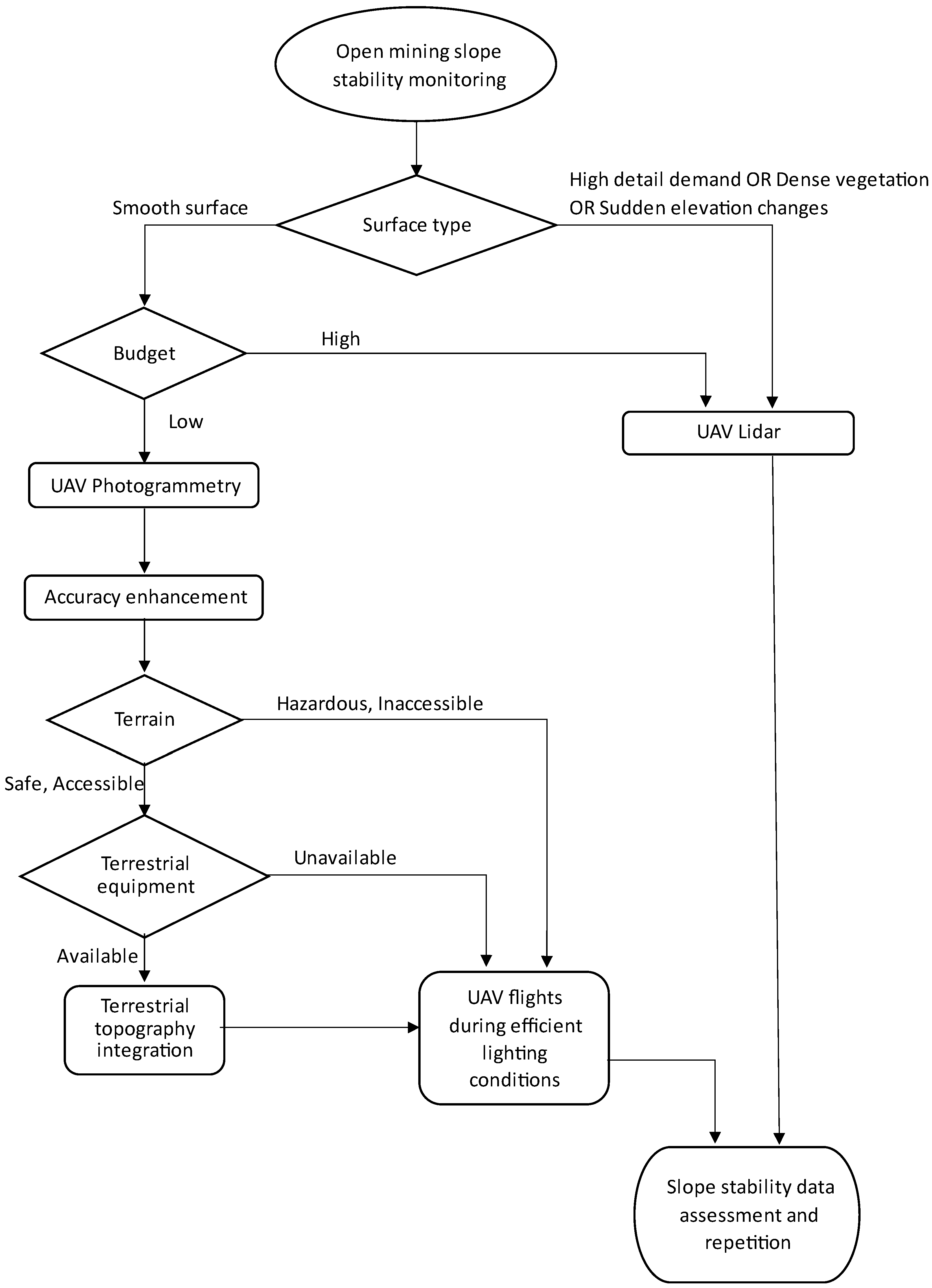
3.2. Key Methodological Themes

This section examines the methodological advances shaping UAV-based research: photogrammetry vs. LiDAR workflows, RGB vs. multispectral sensors, machine learning for feature extraction, and multi-temporal or change-detection methods.

3.2.1. Photogrammetric Techniques and Workflow

Photogrammetry remains a mainstay in UAV-based mapping, particularly through Structure from Motion (SfM) and Multi-View Stereo (MVS).
A typical workflow involves the following:
  • Flight Planning: Determining flight lines, altitudes, side overlaps, and vantage angles for complex slopes or dump surfaces [2,22];
  • Image Acquisition: Usually, hundreds or thousands of images in systematic patterns [4,10,14,30];
  • SfM/MVS: Automatic tie-point extraction, camera self-calibration, and dense matching [7,13,15,25];
  • DEM/Orthomosaic Generation: Producing a unified raster or mesh, then exporting the results into GIS software for volume and slope stability analyses [13,29].
  • Advantages include relatively low cost, ease of data gathering, and sub-decimeter resolution. Yet, photogrammetry struggles if surfaces lack texture or color variation, e.g., uniform fine-grained tailings or dark coal surfaces [3,12]. Shadows or steep bench faces can also degrade tie-point matching. Despite these issues, photogrammetry remains the go-to method for volumetric computations, land cover classification, and general site mapping across numerous slope stability applications [1,7,22,29].

3.2.2. UAV-Borne LiDAR and Multi-Sensor Fusion

While photogrammetry is robust, UAV LiDAR overcomes some of its weaknesses, notably in low-texture or vegetated zones. By emitting laser pulses and recording returns, LiDAR can penetrate vegetation canopies or dark surfaces more effectively [3,26]. One coal-mining case revealed how LiDAR captured geometry in areas where photogrammetry’s key-point matching failed due to reflectivity gaps [3].
In this context, UAV LiDAR’s strengths are summarized as follows:
  • Independent of ambient lighting or color contrast;
  • Able to filter ground vs. vegetation returns to produce more accurate bare-earth models;
  • High point densities, often hundreds of points/m2, are beneficial in steep or irregular slopes [3].
Persisting limitations include higher cost, complex hardware integration, shorter flight times (due to heavier payloads), and no returns from water or extremely dark materials [3,12]. Some projects merge LiDAR geometry with RGB orthophotos to yield “colorized point clouds”, blending spectral and geometric data [3,29]. Others incorporate thermal or hyperspectral sensors to detect temperature anomalies (spontaneous combustion in dumps) or geochemical patterns (pollutant distributions) [8,12].

3.2.3. Machine Learning and Automated Feature Extraction

Machine learning (ML), particularly deep learning, has rapidly gained traction for interpreting UAV imagery. Instead of manual digitization of cracks or vegetation polygons, ML approaches can automate classification or object detection. In UAV photogrammetry for open-pit mines, convolutional neural networks (CNNs) automatically learn image features from orthomosaics or point clouds, enabling centimeter-scale detection of cracks, loose blocks, and vegetation stress once trained on labeled data [2,23]. A typical pipeline might involve the following:
  • Labeling: Human experts annotate training samples (e.g., “trees”, “grassland”, “shadows”, “rock fractures”, etc.) [2,14];
  • Model Training: Convolutional neural networks (CNNs), such as U-Net or Mask R-CNN, learn from labeled orthophotos or point clouds [2,32];
  • Validation: Accuracy, confusion matrices, or kappa coefficients measure performance [2,12,23];
  • Deployment: Models are applied to new UAV flights for multi-temporal analyses or real-time hazard detection.
CNN-based classification reached overall accuracies of ~90%, especially when combining orthophotos with DSM data [2]. Meanwhile, random forest or SVM classifiers use tabulated spectral and geometric attributes (e.g., RGB values, NDVI, and local slope) to separate intact rock, spoil, or self-heating zones and have proved effective for tasks such as acid mine drainage mapping and particle size estimation [7,23]. Some researchers tailor ML models to detect small displacements, lineaments, or tension cracks in high-res UAV imagery [6,25], though reliability depends on robust training sets, consistent lighting, and stable georeferencing.
For mine waste dumps, ML can also estimate the distribution of rock particle sizes (PSD) from aerial images or detect self-heating hotspots [12,36]. These applications demonstrate how advanced analytics can reduce the need for labor-intensive ground investigations, leading to more proactive slope or dump management.
Table 2 summarizes Section 3.2.1 and Section 3.2.2 and presents the key points of comparison between the UAV photogrammetry and Lidar methodologies as a simple and basic manual addressed to the conventional user.
In addition, the flowchart of Figure 1 illustrates the decision-making process for UAV photogrammetry and UAV LiDAR options, with alignment to the factors of the mining surface, cost, safety, and accessibility of the mining sites.

3.2.4. Monitoring Spatiotemporal Changes

A central purpose of UAV-based slope stability research is to quantify deformation or failure processes over time [3,14]. By repeating flights, analysts can derive the following:
  • DEM Differencing: Subtract DEMs from subsequent surveys to identify volumetric changes (e.g., slump volumes and waste pile expansions).
  • Feature Tracking: Tie-point matching across orthophotos to measure horizontal shifts or crack expansions.
  • Time-Series Analysis: Observing progressive slope movement or vegetation changes to identify early warnings [22,36].
  • Researchers of an open-pit lignite project discovered a landslide by comparing LiDAR surveys from two different months, observing a large slip [3]. Another study used repeated UAV flights to track the thermal behavior of coal waste dumps, revealing how infiltration or rainfall can influence spontaneous combustion events [12]. The UAV-based methodologies are not real-time, since flights typically occur weekly, monthly, or ad hoc, but they vastly improve spatiotemporal coverage over older methods.

3.3. Critical Analysis of the Thematic Review Findings

Based on the findings presented in the previous paragraphs, a critical analysis of the thematic review was conducted using a SWOT analysis approach. Undoubtedly, UAV technology has reshaped geotechnical monitoring in open-pit mines and waste dumps over the past decade. The strengths of UAV-based monitoring of surface mining operations are presented in Table 3.
Nonetheless, challenges remain. Weather constraints, flight regulations, data overload, and a lack of standardized best practices hamper broader deployment [3,13,15]. Photogrammetry and LiDAR each have inherent limitations. Some sites can adopt multi-sensor solutions, while others might rely on simpler photogrammetry for budget reasons [26,30]. The weaknesses of UAV-based monitoring of surface mining operations are presented in Table 4.
Furthermore, UAV-based remote sensing stands at the forefront of an ongoing paradigm shift in slope stability and dump management. With further technological refinements, policy frameworks, and multi-sensor standardization, UAVs hold the potential to revolutionize not just how mines capture data, but how they respond to emergent failures and plan reclamation and protect workers and surrounding communities [1,3,13,22]. In this context, the opportunities for UAV-based monitoring of surface mining operations are summarized in Table 5.
Despite the advantages of UAV technology, several challenges threaten its effective deployment in surface mining. These threats range from technical constraints, such as data processing demands and sensor limitations, to operational concerns, including regulatory uncertainties and real-time monitoring gaps. Table 6 outlines the key risks that must be addressed to ensure the long-term viability and reliability of UAV-based slope stability monitoring.

4. Current Trends and Gaps

4.1. Key Thematic Trends

Over the last decade, Unmanned Aerial Vehicles (UAVs) have rapidly transitioned from novelty tools to integral components of open-pit mining, mine waste dump surveillance, and slope stability evaluations. UAV-based photogrammetry and LiDAR techniques offer unprecedented detail in mapping complex geometries and detecting instabilities across large or hazardous landscapes [3,5,12,23]. While the literature widely acknowledges the efficacy of UAV remote sensing for capturing high-resolution data in short times, a critical review reveals key thematic trends as well as persistent gaps that need addressing for UAV solutions to become more standardized, robust, and truly real-time [7,8].

4.1.1. Trend 1: Photogrammetry as a Cost-Effective Standard

  • Photogrammetry, especially using Structure from Motion (SfM) and Multi-View Stereo MVS, dominates UAV-based mapping in surface mining [2,19,27,30]. Thanks to improvements in off-the-shelf UAVs and open-source or commercial photogrammetry software, collecting hundreds or thousands of overlapping images (70–80% overlap) is technically straightforward [13,30,31]. The subsequent 3D point clouds and orthophotos achieve ground sampling distances of just a few centimeters, feasible with standard UAVs [36] and the integration of ground control points (GCPs) [2,35], enabling accurate volumetric calculations, slope angle assessments, and general site monitoring [16,24,27].
  • Strength: Relatively low financial outlay compared to manned aerial surveys or expensive terrestrial scanners.
  • Weakness: Performance drops when surfaces are dark (e.g., coal spoil) or uniform in texture, while steep walls cast problematic shadows [3,8,12].
  • Implication: Despite widespread acceptance, photogrammetry alone struggles in multi-vegetated or uniform tailings scenarios, suggesting the need for sensor fusion or advanced modeling [13,22].

4.1.2. Trend 2: The Rise of UAV LiDAR in Complex Terrains

UAV LiDAR has emerged to mitigate texture or illumination dependencies [3,13,26]. Several studies show how LiDAR’s active laser scanning better captures bare-earth surfaces under vegetation canopies or yields data in near-uniform benches [7,12,26,29]. LiDAR point clouds also avoid parallax issues in steep or vertical sections of open-pit walls. However, LiDAR hardware remains costlier and heavier, limiting flight time on typical rotary UAVs [3,4,32]. Reflectivity gaps over water or extremely dark materials persist [12], and the post-processing workflow requires specialized software.
  • Strength: Capable of extremely dense scans (hundreds of points/m2) that can highlight subtle cracks or displacements.
  • Weakness: Hardware expense and integration complexities (IMU, GNSS, and flight planning).
  • Implication: UAV LiDAR is still not as ubiquitous as photogrammetry, but for challenging sites—vegetation, deep shadow zones, and uniform tailings—LiDAR may be critical to high-fidelity topographic mapping.

4.1.3. Trend 3: Machine Learning and Deep Learning Integration

Machine learning (ML), as described in par 3.2.2, particularly deep learning (DL), has become increasingly prevalent for automating feature extraction (e.g., land-cover classification, crack detection, or self-combustion risk identification), achieving accuracies up to 95% [2,7,9,12,14,17,23]. This automation can drastically reduce manual digitization efforts in large-scale mines. Additionally, random forest or SVM classifiers are used for spectral-based tasks such as acid mine drainage discrimination [18], vegetation health monitoring [29], or slope hazard mapping [23].
  • Strength: Minimizes manual workload, reveals hidden patterns, and enables the near-automatic detection of anomalies or high-risk zones.
  • Weakness: High reliance on labeled training datasets, which may not transfer well across different geological or climatic conditions [14,19,23].
  • Implication: Rapidly growing domain but lacking standard protocols. Inconsistent labeling or site specificity can hamper real-world adoption outside the original research context.

4.1.4. Trend 4: Expanding Focus on Dump Stability and Environmental Reclamation

While early UAV research centered on pit walls or general mine surveying, mine waste dumps have gained attention due to spontaneous combustions, slope collapses, and environmental impacts [9,12,22,29]. Drone-based thermal imaging identifies self-heating in coal spoil, while multispectral or hyperspectral sensors track vegetation regrowth or chemical signatures of tailings [26,36]. Some authors demonstrate integrated photogrammetry–LiDAR–ML pipelines for continuous monitoring, but the references highlight how many waste dump studies remain small-scale or pilot-based.
  • Strength: UAVs help map unstable or hazardous dumps that would be too dangerous for ground crews.
  • Weakness: No universal guidelines exist for safe UAV flight over spontaneously combusting spoil, and data are typically acquired at discrete intervals rather than continuously.
  • Implication: As open-pit operations produce larger dumps, UAV-based solutions become indispensable. Yet standardization, especially in ignition detection and 3D hazard modeling, is still lagging [12].

4.2. Key Gaps and Limitations

While UAV technology has exhibited significant advances in surface mine monitoring, as discussed in previous paragraphs, several gaps and limitations remain that must be addressed to enhance its applicability and effectiveness. These challenges encompass monitoring protocols, scalability, data standardization, and integration with existing geotechnical methods. The following list highlights the key areas identified in this literature review that require further research and development to fully realize the potential of UAVs in mining operations:
  • Long-Term Monitoring Protocols: Frequent UAV flights are logistically challenging. Many studies rely on single flights or short-term or sporadic multi-temporal campaigns [3,8,16,29,36]. Sustained weekly or monthly UAV flights integrated with in situ sensors, especially to predict early deformations, remain relatively rare [9]. Moreover, real-time or near-real-time data integration with slope stability radars or GNSS networks is not fully addressed [13,15].
  • Scalability and Automation: Most UAV-based solutions remain semi-manual—flight planning, GCP deployment, model calibration, and machine learning labeling. High labor demands limit scale in mega-mines or multi-bench environments [9,27,30]. True automation, such as autonomous recharge or drone swarms, is still experimental [13,14].
  • Data Standardization and Validation: Studies often vary widely in-flight parameters, GCP distribution, or machine learning metrics [2,12,23]. Cross-validation or transferring a CNN model from one mine to another is rarely attempted, so the field lacks consistent ground truth frameworks [22,32].
  • AI Standardization: Although CNN-based land-cover classification [2,7] or random forest PSD analysis exist, best practices for labeling, training, and cross-site models remain inconsistent.
  • Cost–Benefit Analyses: Though UAVs are reputed to be “cost-effective”, few publications provide lifecycle cost comparisons vs. ground-based laser scanning, slope stability radars, or manned aircraft [1,13,26,29]. Without objective analyses, site operators may hesitate to invest in advanced UAV LiDAR or multi-sensor payloads.
  • Bridging Micro-Displacement Detection and Geotechnical Action: UAV data often detect advanced slope failures or broad movements [3], but turning small, early-stage displacements into immediate stabilization measures is less established [13].
  • Integration with Geotechnical Data: While the morphological detection of cracks or bulges is frequent, combining UAV morphological data with in situ geotechnical measurements like pore pressures, friction angles, or seismic velocity profiles remains minimal in the open literature [12,13,29]. This gap hinders a truly integrated approach to slope stability predictions.
  • Mine Waste Dumps: While numerous references [22,29,36] highlight the significance of dumps, further studies on multi-sensor integration for spontaneously combusting or chemically reactive dumps are needed. Thermal or hyperspectral UAV sensors, combined with geoelectrical or magnetometric resistivity approaches [26,32], could yield comprehensive risk assessments.
  • Regulatory and Ethical Considerations: Mining areas near airports or populated regions may face UAV flight restrictions, limiting routine data collection [13,15,23].

4.3. Critical Reflections

The above trends and gaps indicate that UAV-based slope stability research stands at an inflection point. The technology has proven its utility for short-term or pilot-scale projects, but broader industrial assimilation requires (1) robust workflows for repeated high-frequency mapping; (2) standard machine learning pipelines to ensure reproducibility; and (3) regulatory clarity to streamline UAV flights in active mining zones [5,15,34,36]. Moreover, advanced sensor suites (thermal and hyperspectral) hold promise for tackling unique geochemical or ignition hazards in mine waste dumps, yet their usage remains sporadic and lacking in universal guidelines [12,32].
Ultimately, UAV adoption is propelled by the synergy of advanced hardware (LiDAR and multispectral cameras) with powerful data processing (photogrammetry and ML). Addressing fundamental challenges (like real-time data needs, cost justification, and site-specific modeling) will be key to bridging the gap between current academic case studies and full-scale, daily operational usage in slope stability management [13,19,23,36].
Photogrammetric accuracy and LiDAR precision each depend on multiple factors, including the type and quality of the camera, the flight altitude, and atmospheric conditions like shadows and solar illumination. Differences also arise from the particular software (and its internal algorithms) used for processing imagery or LiDAR returns, with each claiming distinct advantages. In photogrammetry, for instance, many packages compute an RMS error (root mean square) as an automatic self-assessment, but this figure merely serves as an indicative estimate—ultimate reliability rests on the operator’s professional judgment. [34]. While photogrammetry can often match LiDAR’s performance in bare or uniform mine terrains, it may lag in more complex scenarios (e.g., thick vegetation or low-contrast surfaces) [3,26]. In practice, direct comparison is feasible only under closely matched flight conditions, sensor parameters, and environmental constraints. Nonetheless, photogrammetry remains an economical, flexible technique capable of near-LiDAR accuracies in suitably prepared or geologically uniform mining sites.

5. Future Directions

As UAV technology continues to evolve, its role in monitoring surface mining operations is expanding beyond periodic surveys toward fully integrated, real-time hazard detection and environmental protection platforms. Future advancements will focus on increasing automation, enhancing sensor fusion, refining machine learning techniques, and establishing standardized best practices. These developments aim to bridge the gap between data collection and actionable geotechnical insights, improving safety and efficiency in open-pit mining and waste dump management. The following paragraphs synthesize the key emerging trends.

5.1. Toward Fully Integrated Monitoring Frameworks

A critical next step lies in integrating UAV solutions into continuous or near-real-time slope stability monitoring [7,13,14,15]. While static or periodic flights provide snapshots, emergent slope instabilities or spontaneous coal mine dump fires may escalate faster than monthly or quarterly flights can capture [12]. Therefore, future research should explore the following topics:
  • Drone Swarms: Multiple UAVs can systematically cover large pit areas in parallel, drastically reducing survey times [4,15,36]. Coordinated flight paths allow near-simultaneous data capture, minimizing temporal inconsistencies.
  • Automated Hubs: Self-recharging stations would let UAVs land, recharge, and relaunch on pre-set schedules or triggered by alerts (e.g., from in situ sensors detecting micro-seismic events) [14].
  • Continuous Data Fusion: UAV data might be fused with real-time slope stability radars or GNSS networks. If radar indicates suspicious displacement, UAVs could be deployed immediately for finer 3D detail [9,13,23].
Such frameworks demand robust autonomy, safe collision avoidance, and regulatory acceptance for autonomous flights, all of which are in early development [13,35].

5.2. Advances in Sensor Fusion and Multi-Sensor Payloads

Sensor diversity is crucial for capturing the full complexity of open-pit mines and waste dumps:
  • Thermal Cameras: Essential for spotting hotspots in coal waste piles or tailings. Combining orthomosaic temperature data with 3D geometry can detect early-stage self-heating [12,36].
  • Hyperspectral Sensors: Mapping mineralogical or chemical properties relevant to acid mine drainage or heavy-metal contamination in tailings [18,26].
  • Ground Penetrating Radar or Magnetometric Devices: Potentially workable if the UAV lift capacity increases, enabling sub-surface anomaly detection or preferential flow path identification [32].
  • Real-Time Gas Sensors: CO, CH4, or other harmful gases might be measured to gauge combustion or toxicity in mine dumps [5,12,29].
Combining data from these sensors with standard RGB or LiDAR yields a multimodal dataset. However, the large data volumes and complexities of registration require advanced software solutions. Future efforts may develop integrated processing pipelines (e.g., a single software environment) that handle photogrammetry, LiDAR, thermal, and hyperspectral in one pass [8,14,23].

5.3. Evolving Machine Learning Methodologies

ML and DL have proven vital for automating land-cover classification, crack detection, or slope hazard identification [2,7,17,23]. Moving forward, the following topics should be studied:
  • Transfer Learning and Federated Models: Instead of training separate CNNs for each mine, a generalized “foundation model” could be fine-tuned to local conditions [14,15]. This demands well-structured, labeled datasets from diverse geology so that networks learn robust features (e.g., cracks, rock outcrops, and vegetation patterns).
  • Three-dimensional Deep Learning: Rather than analyzing 2D orthophotos, future algorithms can directly consume 3D point clouds (LiDAR or dense SfM) to detect shapes that indicate slope movement [3,9,12,32].
  • Change Detection Networks: ML can also handle multi-temporal data to highlight minute morphological shifts, automatically flagging zones for geotechnical follow-up [23,36].
  • Uncertainty Estimation: In geotechnical risk contexts, generating not just a predicted classification but an uncertainty measure is crucial for decision making [12,13]. ML frameworks that provide confidence intervals or Bayesian inference would help operators weigh hazard levels more precisely.

5.4. Standardizing Protocols and Best Practices

One pressing need is the formalization of best practices for UAV-based slope stability:
  • Flight Planning: Minimum recommended overlaps, altitudes, and GCP distributions for typical open-pit or dump geometries [2,23,36].
  • Accuracy Metrics: Standard definitions for horizontal vs. vertical root mean square error (RMSE) or confusion matrix thresholds in ML classification [13,22].
  • GCP and Checkpoints: Clear guidelines on how to place, measure, and interpret GCP distribution in hazardous or restricted areas [22,24].
  • Data Formats: Interoperable data outputs (LAS/LAZ for point clouds and GeoTIFF for orthomosaics) and metadata to ensure reproducibility [24,30].
  • Safety Protocols: For spontaneous combustion zones, establishing safe flight heights, emergency flight abort procedures, or thermal sensor calibrations [12,19].
International organizations in geotechnical engineering or mining (e.g., ISRM, SME, and CIM) could spearhead these frameworks, analogous to how photogrammetry standards have developed for civil surveying [3,10,15].

5.5. Toward Real-Time Hazard Warning

A major leap would be bridging the gap from map-making to live hazard detection. Real-time UAV data streams are still rare because flights are short, and post-processing can be lengthy. Future solutions might include the following:
  • Onboard Processing: Although near-real-time photogrammetry or LiDAR data processing with GPU acceleration on UAVs or ground-based stations has begun to receive scholarly and manufacturing attention [40], current implementations remain at a rudimentary stage and demand further research and adaptation to reach their full potential [14,23].
  • Triggered Launch: Automated flights triggered by seismic or geotechnical anomalies, performing a quick scan and delivering analytics to a control room for immediate slope re-design or evacuation measures [13,15].
  • Integration with Internet-of-Things (IoT): Linking drones to wireless sensor networks scattered on the slope or dump face. If sensors detect unusual moisture or strain, a UAV flight is prompted to gather wide-angle data [34,36].
While true real-time detection competes with the practicality of flight durations and data upload constraints, incremental improvements could close the loop between data acquisition and engineering actions within hours rather than days [12,13].

5.6. Environmental Reclamation and Post-Mine Use

UAV-based topographic and spectral data are increasingly central to evaluating the success of revegetation or controlling acid mine drainage [2,18]. As mines move toward closure, the following topics become important:
  • Chronological Mapping: Repeated UAV flights can generate volumetric timelines of re-contouring or vegetation succession [1,29].
  • Sustainability Metrics: Multispectral imagery helps gauge vegetation health (NDVI, etc.), while LiDAR identifies gully erosion. ML can classify plant species or detect invasive growth [2].
  • Public Engagement: High-resolution UAV maps might be shared with local communities or regulators, enhancing transparency around mine reclamation progress.
Future research could refine UAV-based ecological indices, combining hyperspectral reflectance with topographical factors to accurately measure biomass or soil stability [26].

5.7. Bridging Geotechnical Data and 4D Analysis

Finally, advanced slope stability analyses involve not just the surface but sub-surface properties. Integrating UAV observations with borehole data, geophysical surveys, or numerical modeling can yield 4D insights—space plus time plus material parameters [5,12,22]. For instance, the following topics are relevant:
  • Coupled Modeling: UAV-based geometry regularly updates finite-element or discrete-element slope stability simulations to forecast near-future movements [13,32].
  • Automated Model Calibration: Iteratively adjusting friction angles or cohesion in a slope model based on UAV-captured displacements or volumetric changes [3,29].
  • Holistic Risk Maps: Combining geotechnical factor-of-safety outputs with UAV-based morphological trends to highlight zones where small changes might trigger catastrophic failure [2,12,23].
In this manner, UAV data progress from post hoc mapping to a predictive function, enabling safer and more efficient mine planning [15,24,30].

6. Conclusions

UAV-based approaches have revolutionized how open-pit mines and mine waste dumps are surveyed, monitored, and managed, delivering the following:
  • High-resolution photogrammetric or LiDAR data for accurate modeling of terrain and bench geometry;
  • Efficient and flexible deployment, often at a lower cost than manned aerial or extensive ground-based surveys;
  • Machine learning tools for automated anomaly detection, from tension cracks to self-heating in spoil;
  • Environmental insights that help gauge reclamation success and sustainability.
Yet, critical gaps remain. Many studies rely on one-off or short-term multi-temporal campaigns. Long-term, high-frequency UAV frameworks, while feasible in principle, are rarely implemented. Standardized best practices for flight planning, ground control, accuracy metrics, and data validation are needed to ensure reproducibility across different mines and geological contexts. Meanwhile, the integration of UAV data with in situ geotechnical and environmental sensors has just begun. Merging morphological updates from UAV flights with real-time slope stability radar or local instrumentation would yield near-instant hazard detection, bridging the gap between map generation and real-world interventions. This finding is consistent with the previous research of the authors on assessing the capability of UAVs equipped with RGB cameras to monitor the stability of specific slopes in the surface lignite mines in the Ptolemaida Basin, Greece. Displacements were detected by subtracting successive digital terrain models generated using UAVs equipped with RGB cameras and RTK processing, which closely matched the results of high-accuracy surveying, which was conducted using a series of target prisms placed on the crests of mine benches [34].
Looking ahead, the synergy of multi-sensor payloads (thermal, hyperspectral, and LiDAR), autonomous flight scheduling, and advanced machine learning is poised to transform UAV solutions from periodic surveying tools into continuous hazard monitoring systems. Drone swarms, onboard analytics, and triggered flights will address ephemeral slope changes, while robust cost–benefit analyses will justify more comprehensive UAV deployments in large-scale operations. At the same time, as described in another review paper from our research team, the integration of UAV-based terrain monitoring with post-mining land use planning can enhance rehabilitation efforts, ensuring that repurposing strategies align with long-term environmental and socio-economic objectives [41]. Such a future will demand further research, policy refinement, and technical standardization, but it holds the promise of safer mines, more effective waste dump rehabilitation, and deeper integration of UAV data into everyday geotechnical decisions.
By advancing these frontiers, UAV-based slope stability research can mature into a fully realized discipline, which not only captures data swiftly and accurately but also translates real-time or near-real-time terrain knowledge into proactive, life-saving measures across the entire mine lifecycle.

Author Contributions

Conceptualization, S.T. and F.P.; methodology, S.T.; software, S.T.; validation, S.T., F.P., C.S. and V.T.; formal analysis, S.T.; investigation, S.T.; resources, S.T.; data curation, S.T.; writing—original draft preparation, S.T.; writing—review and editing, F.P., C.S. and V.T.; visualization, S.T.; supervision, F.P. All authors have read and agreed to the published version of the manuscript.

Funding

This research received no external funding.

Acknowledgments

The artificial intelligence tool ChatGPT was utilized for language and grammar editing, readability improvements, and text generation. The final manuscript was reviewed, edited, and approved by the authors to ensure scientific integrity and accuracy. The authors take full responsibility for the content, including all interpretations and conclusions drawn from the study.

Conflicts of Interest

The authors declare no conflicts of interest.

References

  1. Söğütcü, G. Low cost deformation analysis of open pit mine by using Unmanned Aerial Vehicle (UAV) technology. Master’s Thesis, Middle East Technical University, Ankara, Turkey, 2024. [Google Scholar]
  2. Yadav, T.K.; Mahavik, N. Development of monitoring open-pit mine rehabilitation based on UAV photogrammetry and deep learning. Master’s Thesis, Naresuan University, Phitsanulok, Thailand, 2020. [Google Scholar]
  3. Coccia, S.; Al Heib, M.; Klein, E. Combination of UAV-borne LiDAR and UAV-borne photogrammetry to assess slope stability. In Proceedings of the 7th World Congress on Civil, Structural, and Environmental Engineering, Online, 10–12 April 2022. [Google Scholar]
  4. Hao, J.; Zhang, X.; Wang, C.; Wang, H.; Wang, H. Application of UAV Digital Photogrammetry in Geological Investigation and Stability Evaluation of High-Steep Mine Rock Slope. Drones 2023, 7, 198. [Google Scholar] [CrossRef]
  5. Padró, J.-C.; Cardozo, J.; Montero, P.; Ruiz-Carulla, R.; Alcañiz, J.M.; Serra, D.; Carabassa, V. Drone-based identification of erosive processes in open-pit mining restored areas. Land 2022, 11, 212. [Google Scholar] [CrossRef]
  6. Shults, R.; Nurpeissova, M.; Burlibayeva, S.; Umirbayeva, A.; Turumbetov, T. Geomonitoring of the open pit mine slopes during subsoil development. Civ. Eng. J. Staveb. Obz. 2024, 33, 50–64. [Google Scholar] [CrossRef]
  7. Xiao, W.; Ren, H.; Sui, T.; Zhang, H.; Zhao, Y.; Hu, Z. A drone-and field-based investigation of the land degradation and soil erosion at opencast coal mine dumps after 5 years’ evolution of natural processes. Int. J. Coal Sci. Technol. 2022, 9, 42. [Google Scholar] [CrossRef]
  8. Wróblewska, M.; Kowalska, M.; Łupieżowiec, M. Slope stability analysis of post-mining dumps with the use of photogrammetric geometry measurements–a case study. Arch. Civ. Eng. 2023, 69, 171–185. [Google Scholar]
  9. Chand, K.; Koner, R. Failure zone identification and slope stability analysis of mine dump based on realistic 3D numerical modeling. Geotech. Geol. Eng. 2024, 42, 543–560. [Google Scholar] [CrossRef]
  10. Battulwar, R.; Valencia, J.; Winkelmaier, G.; Parvin, B.; Sattarvand, J. High-resolution modeling of open-pit slopes using UAV and photogrammetry. In Mining Goes Digital; CRC Press: Boca Raton, FL, USA, 2019; pp. 661–670. [Google Scholar]
  11. Saylan, A.A. Three-Dimensional Modeling and Monitoring of a Man Made Slope Using Images Taken from Unmanned Aerial Vehicle. Master’s Thesis, Dokuz Eylul Universitesi, Konak, Turkey, 2020. [Google Scholar]
  12. Layek, S.; Villuri, V.G.K.; Koner, R.; Chand, K. Rainfall & seismological dump slope stability analysis on active mine waste dump slope with UAV. Adv. Civ. Eng. 2022, 5858400. [Google Scholar]
  13. Vemulapalli, S.C.; Mesapam, S. Slope stability analysis for mine hazard assessment using UAV. J. Indian Soc. Remote Sens. 2021, 49, 1483–1491. [Google Scholar] [CrossRef]
  14. Battulwar, R.; Winkelmaier, G.; Valencia, J.; Naghadehi, M.Z.; Peik, B.; Abbasi, B.; Parvin, B.; Sattarvand, J. A practical methodology for generating high-resolution 3D models of open-pit slopes using UAVs: Flight path planning and optimization. Remote Sens. 2020, 12, 2283. [Google Scholar] [CrossRef]
  15. Shahbazi, M.; Sohn, G.; Theau, J.; Menard, P. UAV-based point cloud generation for open-pit mine modelling. Int. Arch. Photogramm. Remote Sens. Spat. Inf. Sci. 2015, XL-1/W4, 313–320. [Google Scholar] [CrossRef]
  16. Ren, H.; Zhao, Y.; Xiao, W.; Hu, Z. A review of UAV monitoring in mining areas: Current status and future perspectives. Int. J. Coal Sci. Technol. 2019, 6, 320–333. [Google Scholar] [CrossRef]
  17. Chand, K.; Koner, R. Internal mine dump slope stability and failure zone identification using 3D modelling. J. Min. Environ. 2023, 14, 1105–1119. [Google Scholar]
  18. Stalin, J.L.; Gnanaprakasam, R.C.P. Application of unmanned aerial vehicle for mapping and modeling of Indian mines. J. Indian Soc. Remote Sens. 2020, 48, 841–852. [Google Scholar] [CrossRef]
  19. Bar, N.; Kostadinovski, M.; Tucker, M.; Byng, G.; Rachmatullah, R.; Maldonado, A.; Pötsch, M.; Gaich, A.; McQuillan, A.; Yacoub, T. Rapid and robust slope failure appraisal using aerial photogrammetry and 3D slope stability models. Int. J. Min. Sci. Technol. 2020, 30, 651–658. [Google Scholar] [CrossRef]
  20. Chen, J.; Li, K.; Chang, K.-J.; Sofia, G.; Tarolli, P. Open-pit mining geomorphic feature characterisation. Int. J. Appl. Earth Obs. Geoinf. 2015, 42, 76–86. [Google Scholar] [CrossRef]
  21. Francioni, M.; Salvini, R.; Stead, D.; Giovannini, R.; Riccucci, S.; Vanneschi, C.; Gulli, D. An integrated remote sensing-GIS approach for the analysis of an open pit in the Carrara marble district, Italy: Slope stability assessment through kinematic and numerical methods. Comput. Geotech. 2015, 67, 46–63. [Google Scholar] [CrossRef]
  22. Partsinevelos, P.; Agioutantis, Z.; Tripolitisiotis, A.; Schaefer, N. A Review of Unmanned Aerial Vehicles, Citizen Science, and Interferometry Remote Sensing in Landslide Hazards: Applications in Transportation Routes and Mining Environments. In Remote Sensing of Hydrometeorological; CRC Press: Boca Raton, FL, USA, 2017. [Google Scholar]
  23. Wu, X.; Guo, Q.; Zhang, J. Application of double GPS multi-rotor UAV in the investigation of high slope perilous rock-mass in an open pit iron mine. Geotech. Geol. Eng. 2020, 38, 71–78. [Google Scholar] [CrossRef]
  24. Medinac, F.; Esmaeili, K. A Stochastic-Deterministic Discrete Fracture Network Model for Pit Slope Stability Analysis Using UAV Collected Structural Data. In Proceedings of the ARMA US Rock Mechanics/Geomechanics Symposium, Houston, TX, USA, 28 June–1 July 2020. [Google Scholar]
  25. Chand, K.; Mankar, A.K.; Koner, R.; Naresh, A.R.V.S. Dump slope change detection and displacement monitoring using UAV close-range photogrammetry. Sādhanā 2024, 49, 1–19. [Google Scholar] [CrossRef]
  26. Zhan, X.; Zhang, X.; Wang, X.; Diao, X.; Qi, L. Comparative analysis of surface deformation monitoring in a mining area based on UAV-lidar and UAV photogrammetry. Photogramm. Rec. 2024, 39, 373–391. [Google Scholar] [CrossRef]
  27. Gül, Y.; Hastaoğlu, K.Ö.; Poyraz, F. Using the GNSS method assisted with UAV photogrammetry to monitor and determine deformations of a dump site of three open-pit marble mines in Eliktekke region, Amasya province, Turkey. Environ. Earth Sci. 2020, 79, 1–20. [Google Scholar] [CrossRef]
  28. Duarte, J.; Rodrigues, M.F.; Baptista, J.S. Data digitalisation in the open-pit mining industry: A scoping review. Arch. Comput. Methods Eng. 2021, 28, 3167–3181. [Google Scholar] [CrossRef]
  29. Nguyen, B.D. Identifying the Potential Application of Unmanned Aerial Vehicle Technology in Mine Waste Dumps. Inżynieria Miner. 2023, 2, 163–172. [Google Scholar]
  30. Zapico, I.; Laronne, J.B.; Castillo, L.S.; Duque, J.F.M. Improvement of workflow for topographic surveys in long highwalls of open pit mines with an unmanned aerial vehicle and structure from motion. Remote Sens. 2021, 13, 3353. [Google Scholar] [CrossRef]
  31. Beregovoi, D.; Younes, J.; Mustafin, M. Monitoring of quarry slope deformations with the use of satellite positioning technology and unmanned aerial vehicles. Procedia Eng. 2017, 189, 737–743. [Google Scholar] [CrossRef]
  32. Thiruchittampalam, S.; Banerjee, B.P.; Glenn, N.F.; McQuillan, A.; Raval, S. Granular characterisation of coal spoil dump using unmanned aerial vehicle data to enhance stability analysis. J. Rock Mech. Geotech. Eng. 2024. [CrossRef]
  33. Eker, R.; Aydın, A.; Görüm, T. Tracking deformation velocity via PSI and SBAS as a sign of landslide failure: An open-pit mine-induced landslide in Himmetoğlu (Bolu, NW Turkey). Nat. Hazards 2024, 120, 7701–7724. [Google Scholar] [CrossRef]
  34. Tsachouridis, S.; Pavloudakis, F.; Pilalidis, K.; Myronidis, L.; Roumpos, C. Monitoring slope stability in surface mines: Are low-cost UAVs used for excavated rock volume calculations capable of early detection of displacements? MATEC Web Conf. 2022, 373, 00052. [Google Scholar] [CrossRef]
  35. Tong, X.; Liu, X.; Chen, P.; Liu, S.; Luan, K.; Li, L.; Liu, S.; Liu, X.; Xie, H.; Jin, Y.; et al. Integration of UAV-Based Photogrammetry and Terrestrial Laser Scanning for the Three-Dimensional Mapping and Monitoring of Open-Pit Mine Areas. Remote Sens. 2015, 7, 6635–6662. [Google Scholar] [CrossRef]
  36. Kumar, A.; Khanduri, A.; Jain, P.K. Design and development of an autonomous unmanned aerial vehicle for surface coalmines surveillance. J. Phys. Conf. Ser. 2023, 2601, 012003. [Google Scholar] [CrossRef]
  37. Ge, Y.; Wang, H.; Liu, G.; Chen, Q.; Tang, H. Automated Identification of Rock Discontinuities from 3D Point Clouds Using a Convolutional Neural Network. Rock Mech. Rock Eng. 2025, 58, 3683–3700. [Google Scholar] [CrossRef]
  38. Deliormanli, A.H.; Maerz, N.H.; Otoo, J. Using terrestrial 3D laser scanning and optical methods to determine orientations of discontinuities at a granite quarry. Int. J. Rock Mech. Min. Sci. 2014, 66, 41–48. [Google Scholar] [CrossRef]
  39. Chen, Q.; Ge, Y.; Tang, H. Rock discontinuities characterization from large-scale point clouds using a point-based deep learning method. Eng. Geol. 2024, 337, 107585. [Google Scholar] [CrossRef]
  40. DJI Enterprise. How the Matrice 4E Streamlined 3D Modeling for Heritage Protection, YouTube, Uploaded by DJI Enterprise. Available online: https://www.youtube.com/watch?v=C9jRliB46I8 (accessed on 21 February 2025).
  41. Pagouni, C.; Pavloudakis, F.; Kapageridis, I.; Yiannakou, A. Transitional and Post-Mining Land Uses: A Global Review of Regulatory Frameworks, Decision-Making Criteria, and Methods. Land 2024, 13, 1051. [Google Scholar] [CrossRef]
Figure 1. Decision-making process for choosing between UAV photogrammetry and UAV LiDAR.
Land 14 01193 g001
Table 1. Key features of the case studies presented in the reviewed papers.
ReferenceLocationKey Features
Söğütcü, G., 2024 [1]TurkeyOpen-pit gold mine, photogrammetric data, open-source software analysis
Yadav, T.K. & N. Mahavik, 2020 [2]ThailandRehabilitation of an open-pit mine, deep learning implementation, land classification
Coccia, S. et al., 2022 [3]PolandOpen-pit lignite mine, LiDAR and photogrammetry, slope stability assessment
Hao, J. et al., 2023 [4]ChinaIron mine slope stability research, photogrammetric methods
Padró, J.C. et al., 2022 [5]SpainOpen-pit quarries, photogrammetry and GIS combination, water erosion identification
Shults, R. et al., 2024 [6]KazakhstanOpen-pit metal mines, slope collapse analysis, geodetic surveys
Xiao, W. et al., 2021 [7]MongoliaCoal mine dumps’ degradation and erosion, UAV photogrammetry implementation
Wróblewska, M. et al., 2023 [8]PolandSpoil dumps, UAV photogrammetry, slope failure research
Chand, K. & K. Radhakanta, 2024 [9]IndiaDump slope failure zones assessment, 3D numerical modeling, UAVs
Layek S. et al., 2022 [12]IndiaActive coal waste dump, Photogrammetric UAV methods for slope stability assessment
Leo Stalin, J. & R.C.P. Gnanaprakasam, 2020 [18]IndiaMultiple mining sites, integration of UAV technology and traditional survey methods for slope stability and geospatial analysis
Francioni, M. et al., 2015 [21]ItalyGIS, digital photogrammetry and remote sensing integration for slope performance analysis
Wu, X. et al., 2020 [23]ChinaOpen-pit iron mine research, LiDAR method implementation, point cloud data categorization
Medinac, F. & E. Kamran, 2020 [24]U.S.A.Mining pits, UAV photogrammetric methods, and traditional topography integration for slope failure analysis
Chand, K. et al., 2024 [25]IndiaCoal mine dump failures, UAV close range photogrammetry, cloud-to-cloud algorithm for land displacement monitoring
Zhan, X. et al., 2024 [26]ChinaSurface monitoring research on UAV photogrammetry and LiDAR methods
Gül, Y. et al., 2020 [27]TurkeyMarble open pits, GNSS, and UAV photogrammetry integration methods
Zapico, I. et al., 2021 [30]SpainOpen pit mines, vertical UAV photogrammetry for steep slope analysis
Beregovoi, D.V. et al., 2017 [31]AustriaUAV photogrammetry and satellite remote sensing integration, pit slope monitoring
Thiruchittampalam, S. et al., 2024 [32]AustraliaSpoil dump research, UAV photogrammetry, and soil characterization techniques
Eker, R. et al., 2024 [33]TurkeyMapping of deformations using UAV photogrammetry, landslide assessments
Tsachouridis, S. et al., 2022 [34]GreeceOpen-pit coal mine, UAV photogrammetry, and traditional topography integration
Tong, X. et al., 2015 [35]ChinaUAV photogrammetry and terrestrial scanning for open pit mine 3D monitoring
Table 2. Comparison of key points between UAV photogrammetry and Lidar.
FeatureUAV PhotogrammetryUAV Lidar
Data TypeOverlapping 2D images
True-Color Orthomosaics
3D point clouds
Spatial Resolution5–20 cm GSD2–10 cm point spacing
Absolute AccuracyH: 5–10 cm (with GCPs)2–5 cm
Environmental SensitivityLighting, shadow, and texture dependenciesRobust in low lighting
Vegetation PenetrationPoor: Merges vegetation into the surfaceEfficient: Captures distinctive vegetation features
PortabilityHigh: Light equipment and rapid area coverageMedium: Heavier equipment, shorter flight times
CostLow-cost implementation
Average processing demands
Average to high-cost equipment, higher processing demands
Sources: [3,4,24,26,30,34,35,37,38,39].
Table 3. Strengths of UAV-based slope stability monitoring in surface mines.
StrengthDescription
Fine-Scale Spatial ResolutionUAVs can map complex slopes in hours, achieving centimeter-level details unattainable by many satellite or manned aircraft systems [2,4,27,30].
Rapid CoverageUAVs enable fast deployment, reducing survey times in large areas [2,4,27,30].
Enhanced SafetySurvey teams avoid unstable or combusting waste piles, limiting human exposure to hazards [22,29].
Multi-Sensor VersatilityRGB, thermal, LiDAR, or hyperspectral payloads can handle slope stability, environmental, or operational tasks simultaneously [9,22,26,32].
Long-Term Cost SavingsOnce UAV hardware and training are in place, repeated flights become relatively low-cost, which is essential for ongoing monitoring [12,13,29].
Table 4. Weaknesses faced in the development of UAV-based slope stability monitoring in surface mines.
WeaknessDescription
Regulatory ConstraintsNational aviation policies may cap flight altitudes, require line-of-sight operations, or complicate UAV usage near active mines [3,13,15].
Weather DependenciesHeavy wind, dust, or fog hamper UAV flights. Winter conditions delayed surveys in some lignite mines [3,23].
Sensor GapsPhotogrammetry fails in uniform or shadowed surfaces, LiDAR sees “no return” in water or extremely low-reflectivity zones [12].
Inconsistent StandardsThe lack of universal best practices for flight planning, accuracy thresholds, and machine learning validation complicate cross-site comparisons [7,13,22].
Limited Flight DurationsShort flight durations limit the coverage area in large or complex mine sites.
Data Integration ChallengesThere is difficulty in integrating UAV data with in situ sensors for real-time monitoring.
High Initial CostsDespite claims of cost-effectiveness, the initial investment in UAV systems, especially with advanced sensors like LiDAR or thermal cameras, can be prohibitive for some operators.
Table 5. Opportunities that can foster the development of UAV-based slope stability monitoring in surface mines.
OpportunityDescription
Scientific IntegrationDifferent scientific areas could benefit from the research and fundamentally create multi-purpose tools for the mining industry based on data gathered from UAV applications.
AI and Machine Learning IntegrationAI models can be developed for automatic data analysis, improving hazard detection and decision making.
Environmental MonitoringUAVs can monitor post-mining reclamation, including vegetation health and acid mine drainage.
Table 6. Threats faced in the development of UAV-based slope stability monitoring in surface mines.
ThreatDescription
Photogrammetry and LiDARSome studies champion LiDAR as superior for slope geometry, while others rely on cost-friendly photogrammetry [3,8,30,31]. Clear criteria, such as terrain characteristics, should be considered when deciding on the most appropriate method or their combined implementation.
Data Overload and ProcessingLarge volumes of imagery or LiDAR data demand powerful computing, specialized software, and robust training in photogrammetry or ML [1,2,32].
Machine Learning ReliabilityAlthough high accuracies are reported in controlled tests [3,9], real-world conditions may lower performance. Transferability across different geology or climate contexts remains underexplored [12,14].
Monitoring FrequencyUAV surveys are typically discrete events, whereas slope failures can be sudden. Questions arise whether UAV data can be integrated into near-real-time hazard management frameworks [13,15].
Technological LimitationsWhile UAVs are advancing, technical constraints such as payload capacity and battery life remain significant barriers in large-scale operations.
Regulatory ConstraintsNational aviation policies may cap flight altitudes, require line-of-sight operations, or complicate UAV usage near active mines [3,13,15].
Disclaimer/Publisher’s Note: The statements, opinions and data contained in all publications are solely those of the individual author(s) and contributor(s) and not of MDPI and/or the editor(s). MDPI and/or the editor(s) disclaim responsibility for any injury to people or property resulting from any ideas, methods, instructions or products referred to in the content.

