Characteristics and Forecasting of Rocky Desertification Dynamics in the Pearl River Source Region from 1990 to 2030
Abstract
1. Introduction
2. Study Area Overview and Data Sources
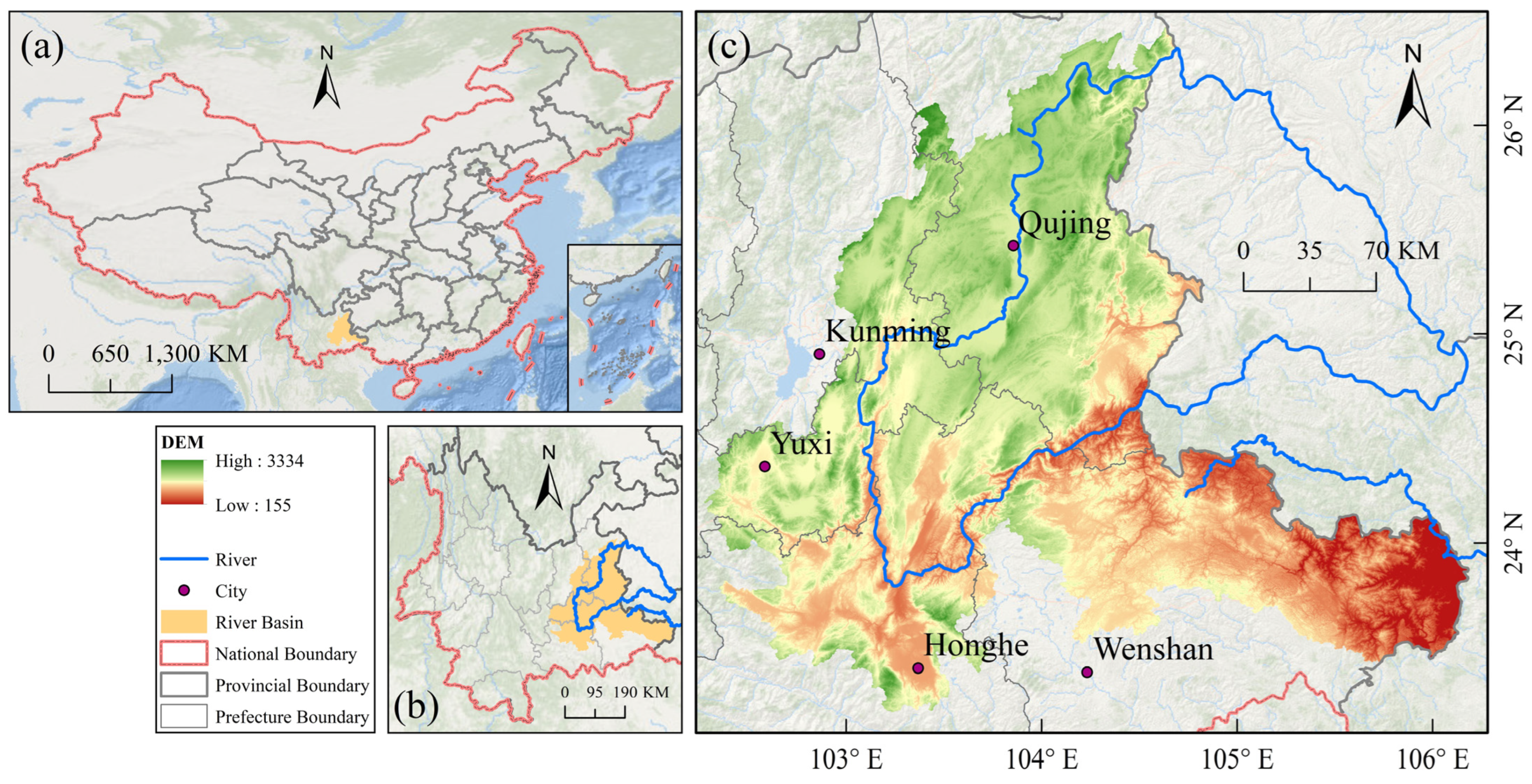
2.1. Study Area Overview
2.2. Data Sources
3. Research Methodology
3.1. Rocky Desertification Indicators
3.1.1. Fractional Vegetation Cover (FVC)
3.1.2. Rock Exposure Rate (RER)
3.2. Classification and Interpretation of Rocky Desertification
3.2.1. Classification Standards for Rocky Desertification
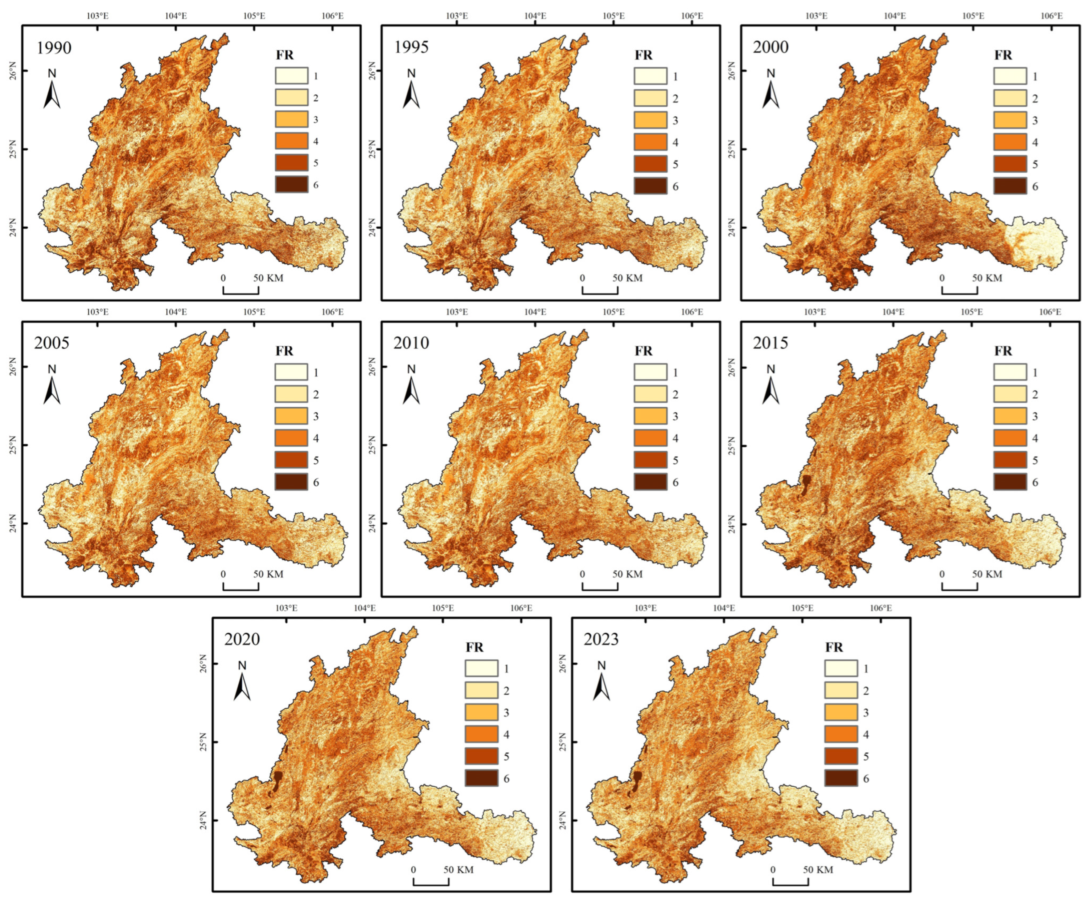
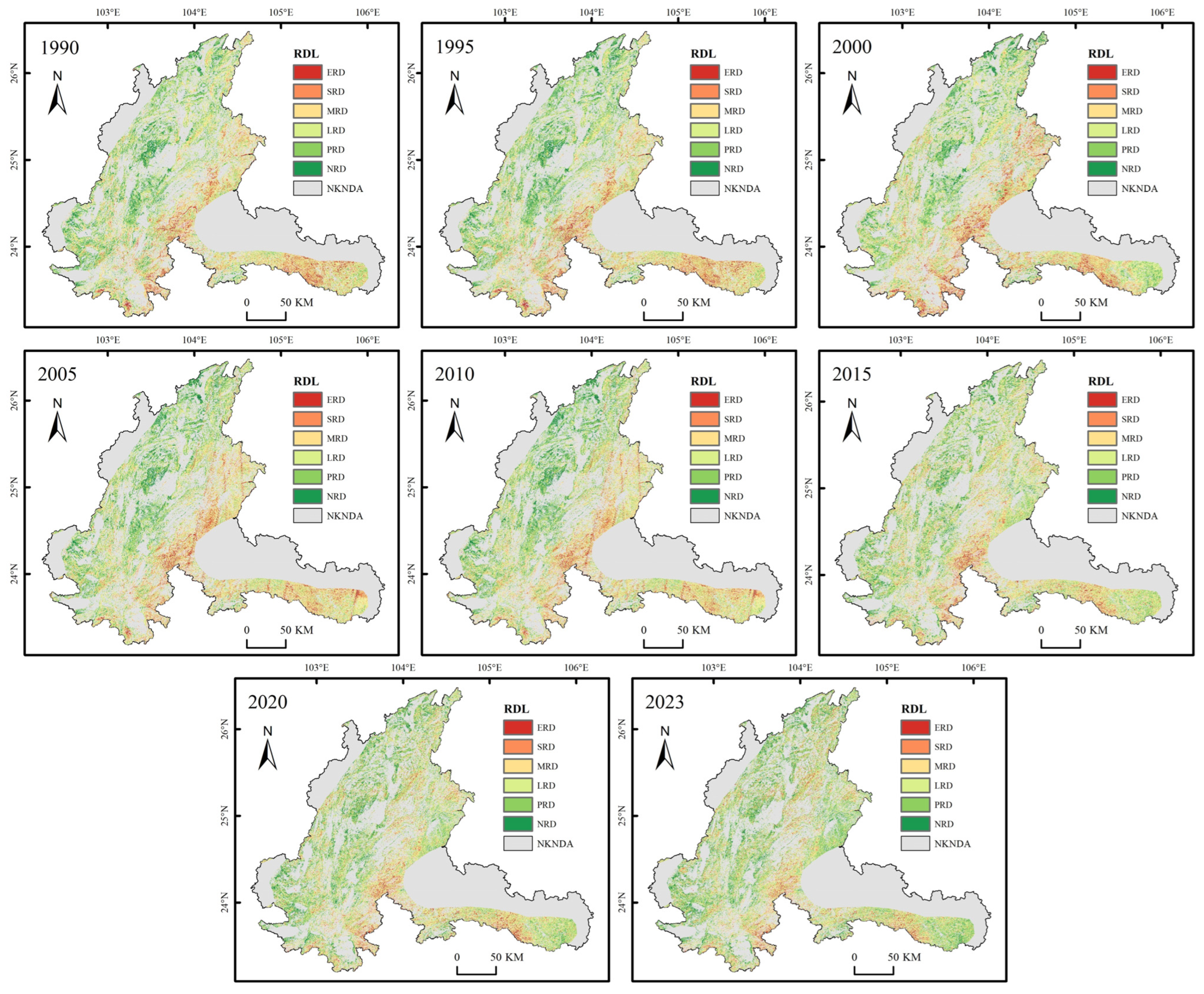
3.2.2. Mapping of Rocky Desertification
3.3. Transfer and Transformation of Rocky Desertification
3.3.1. Transfer Matrix
3.3.2. Rate of Rocky Desertification Transformation
3.4. Development Trends and Predictions of Rocky Desertification
3.4.1. Sen-MK Trend Analysis
3.4.2. CA-Markov Forecast
4. Results and Analysis
4.1. Spatiotemporal Distribution Characteristics of Rocky Desertification from 1990 to 2023
4.1.1. Overall Characteristics of Rocky Desertification
4.1.2. Results of the Transition Matrix
4.1.3. Rock Desertification Transfer Rate
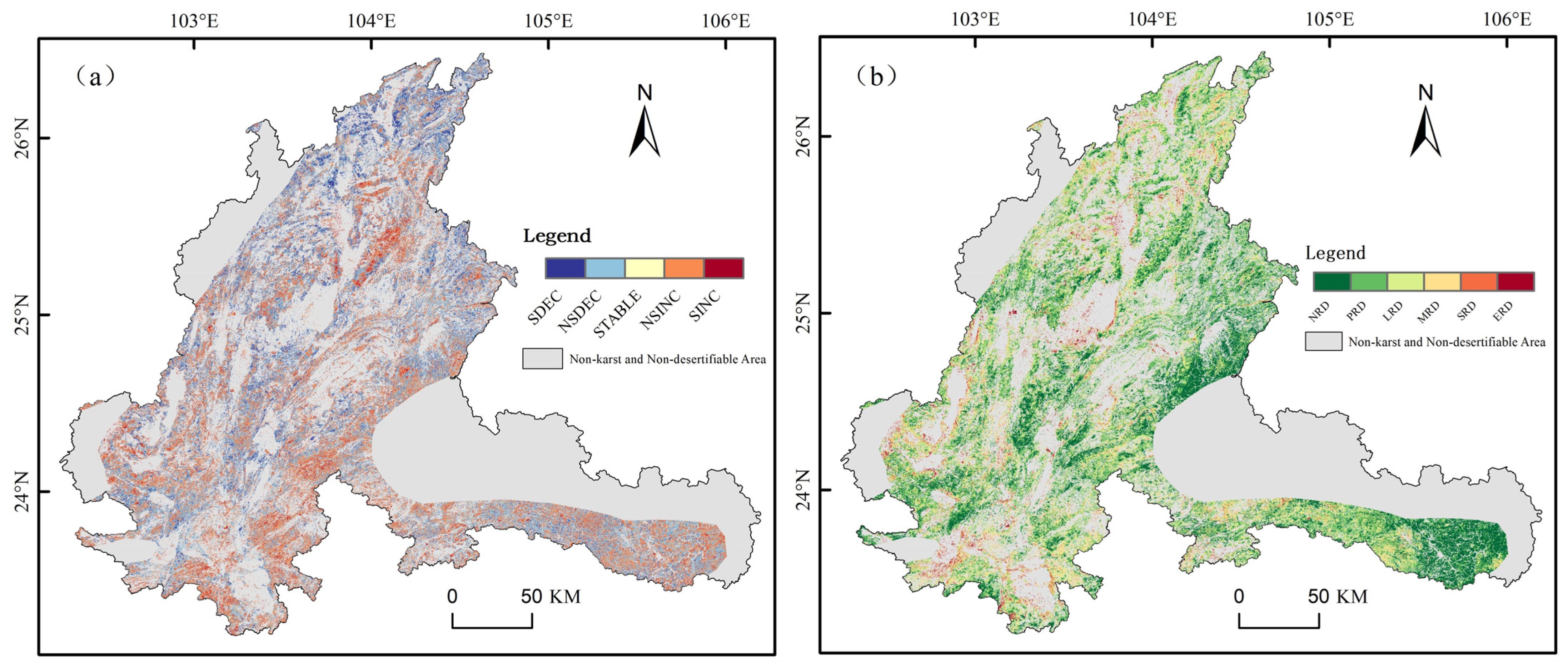
4.2. Spatiotemporal Distribution Features of Rock Desertification
5. Discussion
5.1. Desertification Spatial–Temporal Distribution and Its Evolutionary Characteristics
5.2. Discussion of the Accuracy of Desertification Prediction Results
5.3. Limitations and Future Prospects
6. Conclusions
- (1)
- Over three decades, rocky desertification in the Pearl River source basin of Yunnan Province was found to be distributed to varying extents across the study area, with significant desertification primarily occurring in Qujing City and Wenshan Zhuang Autonomous Prefecture. The area of mildly desertified regions remained relatively stable, while the areas with moderate and severe desertification showed a significant decreasing trend, with the transition from moderate to mild desertification being the most pronounced. The total desertified area within the study area decreased from 14,272.65 km2 in 1990 to 12,040.52 km2 in 2023, a reduction of 2232.13 km2, indicating a significant decline in the total area affected by desertification.
- (2)
- Using the Sen + MK trend test and the CA-Markov model, predictions were made regarding the future development of rocky desertification in the Pearl River source basin. The forecast suggests that, if current management efforts are maintained, the area affected by desertification will continue to decrease by 2030, with a slight increase in the area of non-desertified and potentially desertified land, and a continued trend of deep-level desertification transitioning to shallow-level desertification.
- (3)
- The study confirmed the effectiveness of the method combining the Google Earth Engine platform with traditional remote sensing and Geographic Information System (GIS) technologies for extracting and analyzing desertification information. This approach enhanced data processing efficiency, reduced the challenges associated with handling large volumes of data, and ensured the reliability of extraction accuracy. The accuracy of the study’s results was corroborated by previous literature, indicating that this method holds promising application prospects and significant potential for future research in the field of desertification. However, the uncertainty of the predictive models and regional differences remain areas for further investigation in future studies, to improve the precision and applicability of the predictions. This study provides a scientific foundation and technical support for desertification prevention and ecological restoration efforts in the Pearl River source basin and similar regions, offering new insights into the efficient extraction of desertification data.
Author Contributions
Funding
Data Availability Statement
Acknowledgments
Conflicts of Interest
References
- Wang, S.J. Concept deduction and its connotation of karst rocky desertification. Carsologica Sin. 2002, 21, 101–105. [Google Scholar]
- Wang, K.L.; Zhang, C.H.; Chen, H.S.; Yue, Y.M.; Zhang, W.; Zhang, M.Y.; Qi, X.K.; Fu, Z.Y. Karst landscapes of China: Patterns, ecosystem processes and services. Landsc. Ecol. 2019, 34, 2743–2763. [Google Scholar] [CrossRef]
- Huang, M.T.; Zhai, P.M. Desertification dynamics in China’s drylands under climate change. Adv. Clim. Chang. Res. 2023, 14, 429–436. [Google Scholar] [CrossRef]
- Bi, X.; Yao, Y.; Wang, Z.C.; Li, C.H.; Cao, D.; Wen, L.; Jing, L.; Sun, B. Improving monitoring Karst rocky desertification using high-frequency Landsat observations: A generalized framework and its application to a typical karst region in southeast China. Catena 2024, 241, 16. [Google Scholar] [CrossRef]
- Huang, X.F.; Zhou, Y.C.; Wang, S.J.; Zhang, Z.M. Occurrence mechanism and prediction of rocky land degradation in karst mountainous basins with the aid of GIS technology, a study case in Houzhai River Basin in southwestern China. Environ. Earth Sci. 2019, 78, 13. [Google Scholar] [CrossRef]
- Zhu, Z.; Zhu, T.; Huang, J.; Gu, J.; Yang, L. Dynamic variation analysis of rocky desertification in Xijiang River Basin of Guangxi based on GIS. Sci. Soil Water Conserv. 2018, 16, 19–55. [Google Scholar]
- Chen, S.D.; Wei, X.P.; Cai, Y.L.; Li, H.; Li, L.X.; Pu, J.B. Spatiotemporal evolution of rocky desertification and soil erosion in karst area of Chongqing and its driving factors. Catena 2024, 242, 13. [Google Scholar] [CrossRef]
- Chen, Q.; Zhang, C.; Tian, X.; Shi, X.; Zhang, Y.; Fang, P. Analysis of Spatio-temporal Evolution Process of Rocky Desertification in Qujing Based on Google Earth Engine. J. Southwest For. Univ. 2023, 43, 146–155. [Google Scholar]
- Zhang, S.W.; Wang, Y.; Wang, X.H.; Wu, Y.; Li, C.R.; Zhang, C.; Yin, Y.H. Ecological Quality Evolution and Its Driving Factors in Yunnan Karst Rocky Desertification Areas. Int. J. Environ. Res. Public Health 2022, 19, 16904. [Google Scholar] [CrossRef]
- Zhao, X.; Zhou, Z.; Wang, L.; Luo, J.; Sun, Y.; Liu, W.; Wu, T. Extraction and analysis of cultivated land experiencing rocky desertification in Karst mountain areas based on remote sensing—A case study of Beipanjiang town and Huajiang town in Guizhou Province. Trop. Geogr. 2020, 40, 289–302. [Google Scholar]
- Luo, J.; Liu, S.H.; Ruan, O.; Hu, H.T. Extraction of rocky desertification information using NDVI-Albedo feature space. Bull. Surv. Mapp. 2022, 56. [Google Scholar] [CrossRef]
- Dai, Q.H.; Peng, X.D.; Yang, Z.; Zhao, L.S. Runoff and erosion processes on bare slopes in the Karst Rocky Desertification Area. Catena 2017, 152, 218–226. [Google Scholar] [CrossRef]
- Guo, L.; Zhao, Z.; Dai, Q.; Liang, M.; Fu, X.; Chen, B. Temporal and spatial evolution and genesis of rocky desertification based on RS and GIS in Wenshan Prefecture. Remote Sens. Nat. Resour. 2017, 106–113. [Google Scholar] [CrossRef]
- Cao, J.J.; Wen, X.P.; Zhang, M.M.; Luo, D.Y.; Tan, Y.L. Information Extraction and Prediction of Rocky Desertification Based on Remote Sensing Data. Sustainability 2022, 14, 15. [Google Scholar] [CrossRef]
- Xu, H.; Wang, Y.; Su, Q.; Li, Z.; Jia, Y. Evolution of Rocky Desertification and Driving Factors in Typical Karst Areas of Yunnan Province. J. Arid. Land Resour. Environ. 2022, 36, 94–101. [Google Scholar]
- He, Y.H.Z.; Wang, L.; Niu, Z.; Nath, B. Vegetation recovery and recent degradation in different karst landforms of southwest China over the past two decades using GEE satellite archives. Ecol. Inform. 2022, 68, 11. [Google Scholar] [CrossRef]
- Ying, B.; Xiao, S.Z.; Xiong, K.N.; Chen, Q.W.; Luo, J.S. The Distribution Characteristics of Rocky Desertification and Land Use/Land Cover in Karst Gorge Area. In Proceedings of the 1st International Conference on Energy and Environmental Protection (ICEEP 2012), Hohhot, China, 23–24 June 2012; pp. 4661–4669. [Google Scholar]
- Guo, B.; Yang, F.; Li, J.L.; Lu, Y.F. A novel-optimal monitoring index of rocky desertification based on feature space model and red edge indices that derived from sentinel-2 MSI image. Geomat. Nat. Hazards Risk 2022, 13, 1571–1592. [Google Scholar] [CrossRef]
- Liang, X.; Guan, Q.F.; Clarke, K.C.; Liu, S.S.; Wang, B.Y.; Yao, Y. Understanding the drivers of sustainable land expansion using a patch-generating land use simulation (PLUS) model: A case study in Wuhan, China. Comput. Environ. Urban Syst. 2021, 85, 14. [Google Scholar] [CrossRef]
- Yang, J.; Huang, X. The 30 m annual land cover dataset and its dynamics in China from 1990 to 2019. Earth Syst. Sci. Data 2021, 13, 3907–3925. [Google Scholar] [CrossRef]
- Research Center for Eco-Environmental Sciences, Chinese Academy of Sciences. 2015 Eco-Environmental Issues Data of China (Soil Erosion, Desertification, and Rocky Desertification). 2020. Available online: https://data.casearth.cn/dataset/653f5366819aec161b3b4687 (accessed on 3 February 2024).
- Li, L.L.; Yang, J.T.; Wu, J. A Method of Watershed Delineation for Flat Terrain Using Sentinel-2A Imagery and DEM: A Case Study of the Taihu Basin. ISPRS Int. Geo-Inf. 2019, 8, 528. [Google Scholar] [CrossRef]
- Xi, H.; Wang, S.; Bai, X.; Tang, H.; Wu, L.; Chen, F.; Xiao, J.; Wang, M.; Li, H.; Cao, Y. Spatio-temporal characteristics of rocky desertification in typical Karst areas of Southwest China: A case study of Puding County, Guizhou Province. Acta Ecol. Sin. 2018, 38, 8919–8933. [Google Scholar]
- Zhou, Q.L.; Chen, W.; Wang, H.T.; Wang, D.L. Spatiotemporal evolution and driving factors analysis of fractional vegetation coverage in the arid region of northwest China. Sci. Total Environ. 2024, 954, 16. [Google Scholar] [CrossRef]
- Yan, F.; Guo, X.Y.; Zhang, Y.W.; Shan, J.; Miao, Z.H.; Li, C.Y.; Huang, X.H.; Pang, J.; Chen, Y.H. Analysis of the multiple drivers of vegetation cover evolution in the Taihangshan-Yanshan region. Sci. Rep. 2024, 14, 21. [Google Scholar] [CrossRef] [PubMed]
- Zhang, X.; Gan, S. Research on extracting rocky desertification information based on NDRI dimidiate pixel model. New Technol. New Process 2014, 1, 72–75. [Google Scholar]
- Wang, S.; Li, Y. Discussion on the classification of karst rocky desertification in ecological constructions. Carsologica Sin. 2005, 24, 192–195. [Google Scholar]
- Wang, J.-H.; Li, S.; Li, H.-X.; Luo, H.-B.; Wang, M.-G. Classifying indices and remote sensing image characters of rocky desertification lands: A case of karst region in Northern Guangdong Province. J. Desert Res. 2007, 27, 765–770. [Google Scholar]
- Zhou, Z. Application of remote sensing and GIS technology for land desertification in Guizhou karst region. Bull. Soil Water Conserv. 2001, 21, 52–63. [Google Scholar]
- Xu, E.Q.; Zhang, H.Q. Characterization and interaction of driving factors in karst rocky desertification: A case study from Changshun, China. Solid Earth 2014, 5, 1329–1340. [Google Scholar] [CrossRef]
- Zhang, Z.M.; Zhou, Y.C.; Wang, S.J.; Huang, X.F. Spatial Distribution of Stony Desertification and Key Influencing Factors on Different Sampling Scales in Small Karst Watersheds. Int. J. Environ. Res. Public Health 2018, 15, 743. [Google Scholar] [CrossRef]
- Han, X.Y.; Jia, G.P.; Yang, G.; Wang, N.; Liu, F.; Chen, H.Y.; Guo, X.Y.; Yang, W.B.; Liu, J. Spatiotemporal dynamic evolution and driving factors of desertification in the Mu Us Sandy Land in 30 years. Sci. Rep. 2020, 10, 15. [Google Scholar] [CrossRef]
- Wang, J.F.; Wang, Y.Q.; Xu, D.Y. Desertification in northern China from 2000 to 2020: The spatial-temporal processes and driving mechanisms. Ecol. Inform. 2024, 82, 12. [Google Scholar] [CrossRef]
- Jiang, Z.L.; Ni, X.L.; Xing, M.F. A Study on Spatial and Temporal Dynamic Changes of Desertification in Northern China from 2000 to 2020. Remote Sens. 2023, 15, 1368. [Google Scholar] [CrossRef]
- Chen, F.; Wang, S.; Bai, X.; Liu, F.; Tian, Y.; Luo, G.; Li, Q.; Wang, J.; Wu, L.; Cao, Y. Spatio-temporal evolution and future scenario prediction of karst rocky desertification based on CA–Markov model. Arab. J. Geosci. 2021, 14, 1262. [Google Scholar] [CrossRef]
- Zhang, Y.-R.; Zhou, Z.-F.; Ma, S.-B.; Yang, Q. Analysis and Forecast of the Evolution Features of RockyDesertification Landscape by Markov Model. J. Yangtze River Sci. Res. Inst. 2015, 32, 52. [Google Scholar]
- Dai, G.H.; Sun, H.; Wang, B.; Huang, C.H.; Wang, W.L.; Yao, Y.; Li, N.; Ou, X.K.; Zhang, Z.M. Assessment of karst rocky desertification from the local to regional scale based on unmanned aerial vehicle images: A case-study of Shilin County, Yunnan Province, China. Land Degrad. Dev. 2021, 32, 5253–5266. [Google Scholar] [CrossRef]
- Wu, Q.; Zheng, W.; Rao, C.J.; Wang, E.W.; Yan, W.D. Soil Quality Assessment and Management in Karst Rocky Desertification Ecosystem of Southwest China. Forests 2022, 13, 1513. [Google Scholar] [CrossRef]
- Li, Y.B.; Yu, M.; Zhang, H.; Xie, Y.X. From expansion to shrinkage: Exploring the evolution and transition of karst rocky desertification in karst mountainous areas of Southwest China. Land Degrad. Dev. 2023, 34, 5662–5672. [Google Scholar] [CrossRef]
- Chang, J.Y.; Li, Q.; Zhai, L.; Liao, C.J.; Qi, X.K.; Zhang, Y.; Wang, K.L. Comprehensive assessment of rocky desertification treatment in Southwest China karst. Land Degrad. Dev. 2024, 35, 3461–3476. [Google Scholar] [CrossRef]
- Cai, J.; Yu, W.Y.; Fang, Q.; Zi, R.Y.; Fang, F.Y.; Zhao, L.S. Extraction of Rocky Desertification Information in the Karst Area Based on the Red-NIR-SWIR Spectral Feature Space. Remote Sens. 2023, 15, 3056. [Google Scholar] [CrossRef]
- Callejas, I.A.; Osborn, K.; Lee, C.S.E.; Mishra, D.R.; Gomez, N.A.; Carrias, A.; Cherrington, E.A.; Griffin, R.; Rosado, A.; Rosado, S.; et al. A GEE toolkit for water quality monitoring from 2002 to 2022 in support of SDG 14 and coral health in marine protected areas in Belize. Front. Remote Sens. 2022, 3, 13. [Google Scholar] [CrossRef]
- Guo, B.; Yang, F.; Fan, J.F.; Lu, Y.F. The Changes of Spatiotemporal Pattern of Rocky Desertification and Its Dominant Driving Factors in Typical Karst Mountainous Areas under the Background of Global Change. Remote Sens. 2022, 14, 2351. [Google Scholar] [CrossRef]


| Number | Rank | Rock Exposure Rate (%) | Fractional Vegetation Cover (%) | Slope (°) |
|---|---|---|---|---|
| 1 | NRD | <20 | >70 | <5° |
| 2 | PRD | 20–30 | 50–70 | 5–8° |
| 3 | LRD | 30–50 | 30–50 | 8–15° |
| 4 | MRD | 50–70 | 20–30 | 15–25° |
| 5 | SRD | 70–90 | 10–20 | 25–35° |
| 6 | ERD | >90 | <10 | >35° |
| Year | NRD | PRD | LRD | MRD | SRD | ERD | TRD | |
|---|---|---|---|---|---|---|---|---|
| 1990 | Area (km2) | 4687.97 | 6925.14 | 6077.86 | 4438.45 | 2364.72 | 1391.62 | 14,272.65 |
| Percentage (%) | 7.67% | 11.33% | 9.94% | 7.26% | 3.87% | 2.28% | 23.34% | |
| 1995 | Area (km2) | 4696.04 | 6732.92 | 5550.45 | 4880.53 | 2456.39 | 1569.43 | 14,456.79 |
| Percentage (%) | 7.68% | 11.01% | 9.08% | 7.98% | 4.02% | 2.57% | 23.64% | |
| 2000 | Area (km2) | 4375.35 | 7537.88 | 6059.10 | 4254.62 | 2411.58 | 1247.23 | 13,972.52 |
| Percentage (%) | 7.16% | 12.33% | 9.91% | 6.96% | 3.94% | 2.04% | 22.85% | |
| 2005 | Area (km2) | 5128.26 | 6362.35 | 6557.32 | 4032.03 | 2447.68 | 1329.60 | 14,366.62 |
| Percentage (%) | 8.39% | 10.41% | 10.72% | 6.59% | 4.00% | 2.17% | 23.50% | |
| 2010 | Area (km2) | 5306.17 | 6495.09 | 5671.48 | 4227.53 | 2687.18 | 1461.85 | 14,048.05 |
| Percentage (%) | 8.68% | 10.62% | 9.28% | 6.91% | 4.39% | 2.39% | 22.98% | |
| 2015 | Area (km2) | 5221.05 | 7777.84 | 5919.41 | 4162.38 | 1770.16 | 1034.92 | 12,886.87 |
| Percentage (%) | 8.54% | 12.72% | 9.68% | 6.81% | 2.90% | 1.69% | 21.08% | |
| 2020 | Area (km2) | 5487.81 | 8413.48 | 6124.33 | 3473.35 | 1614.51 | 772.28 | 11,984.46 |
| Percentage (%) | 8.98% | 13.76% | 10.02% | 5.68% | 2.64% | 1.26% | 19.60% | |
| 2023 | Area (km2) | 5492.66 | 8352.58 | 6102.96 | 3501.57 | 1716.50 | 719.48 | 12,040.52 |
| Percentage (%) | 8.98% | 13.66% | 9.98% | 5.73% | 2.81% | 1.18% | 19.69% |
Disclaimer/Publisher’s Note: The statements, opinions and data contained in all publications are solely those of the individual author(s) and contributor(s) and not of MDPI and/or the editor(s). MDPI and/or the editor(s) disclaim responsibility for any injury to people or property resulting from any ideas, methods, instructions or products referred to in the content. |
© 2025 by the authors. Licensee MDPI, Basel, Switzerland. This article is an open access article distributed under the terms and conditions of the Creative Commons Attribution (CC BY) license (https://creativecommons.org/licenses/by/4.0/).
Share and Cite
Sun, H.; Zhang, S.; He, S.; Liu, Z. Characteristics and Forecasting of Rocky Desertification Dynamics in the Pearl River Source Region from 1990 to 2030. Land 2025, 14, 984. https://doi.org/10.3390/land14050984
Sun H, Zhang S, He S, Liu Z. Characteristics and Forecasting of Rocky Desertification Dynamics in the Pearl River Source Region from 1990 to 2030. Land. 2025; 14(5):984. https://doi.org/10.3390/land14050984
Chicago/Turabian StyleSun, Haojun, Shaoyun Zhang, Songyang He, and Zecheng Liu. 2025. "Characteristics and Forecasting of Rocky Desertification Dynamics in the Pearl River Source Region from 1990 to 2030" Land 14, no. 5: 984. https://doi.org/10.3390/land14050984
APA StyleSun, H., Zhang, S., He, S., & Liu, Z. (2025). Characteristics and Forecasting of Rocky Desertification Dynamics in the Pearl River Source Region from 1990 to 2030. Land, 14(5), 984. https://doi.org/10.3390/land14050984


