1. Introduction
Following the communist era, Romania’s land restitution and property rights framework was established through Law No. 18/1991, the Land Fund Law. Enacted in the early post-communist transition, this foundational legislation has been subject to successive reforms to reflect societal transformations and policy priorities. The Land Fund Law’s principal objective is to provide a clear and consistent framework for several key aspects of land ownership and management. These include the acquisition and re-acquisition of property rights, the implementation of transparent procedures for obtaining or regaining land ownership—particularly for agricultural and forestry lands—and the regulation of land transactions. These transactions encompass the sale, purchase, donation, inheritance, and other legal forms of ownership transfer, thus ensuring legal certainty for all stakeholders. Land administration, including the management of land within the public domain of the state or administrative-territorial units, is also addressed, promoting efficient and responsible resource management [
1]. Moreover, the law includes provisions concerning land use restrictions to prevent changes to the designated function of agricultural or forestry land, safeguarding public and environmental interests. This legislation plays a critical role in defining the legal status of land in Romania, establishing the legal framework for ownership, transactions, and related matters. While Law No. 18/1991 [
2] and systematic property registration are interconnected within Romanian land legislation, they represent distinct processes. Law 18/1991 [
2] focuses primarily on the reconstitution of property rights, whereas systematic registration involves the technical and legal documentation of all real estate assets in an integrated cadastral and land registry system.
While legal instruments are typically designed for unitary and uniform application, their practical implementation in Romania has been historically complex due to regionally distinct land registration systems. These discrepancies stem from the diverse geopolitical, historical, and legal contexts that have shaped property systems across Romania’s regions.
Given the need for optimal management of Romania’s territorial division, the introduction of cadastral sectorization into a computer application was required, allowing for a correlation between spatial and textual data. Thus, aiming to organize and coordinate the systematic property registration works, designated personnel from the Cadastre and Real Estate Advertising Offices (OCPI) use GIS to establish the boundaries of cadastral sectors within each administrative-territorial unit (UAT), before initiating the public procurement procedures for systematic registration services. The geospatial data on which the establishment of cadastral sectors is based are as follows: the boundaries of the existing UATs in the Romanian informatic system managed by National Agency of Cadastre and Real Estate Advertising (ANCPI), —eTerra, the orthophotoplan, the boundaries of built-up areas, cadastral plans at scales of 1:2000, 1:5000 or 1:10,000, the boundaries of existing properties in eTerra, and General Urban Plans (PUG) taken from the UATs.
The present research aims to assess the current status and phases of cadastral implementation in Romania by identifying deficiencies, evaluating their impact on economic development, and proposing viable strategies to enhance transparency, accessibility, and operational efficiency. This research endeavors to formulate methodologies for the acquisition and automation of geospatial data and its integration into Geographic Information System (GIS) platforms, to optimize the implementation and performance of the systematic cadastre.
Existing studies in the scientific literature [
3,
4,
5] focus on a certain aspect of the legal framework, or a certain stage of technological application, or cases in specific regions. However, there is a lack of an integrated study that analyses national challenges from multiple dimensions such as history, law, institutions, technology, and socioeconomics and proposes systematic optimization strategies.
The study was conducted with several objectives. The main objective was to automate both the data collection and the integration of data into Romania’s cadastral database. The national implementation of the cadastre has been delayed for various reasons, and in this specific case, Romania is likely to face infringement issues. In this context, it is necessary to develop solutions accepted by the authorities and also readily available to those working in the land surveying and cadastre services sector. Considering the particularities due to the influences of the empires that have passed through our country, this study facilitates the understanding of the de facto situation and valid ways of publishing data from the land registers, including property sales, and the technical–economic evaluation of these properties, thus constituting an essential step in understanding the real estate market in a context very easily influenced by geopolitical factors.
2. Legal, Institutional, and Technical Framework
2.1. Legal and Historical Background
The legal status of land in Romania presents significant regional variations, influenced by historical evolution, region-specific legislation, and prevailing local customs. In Transylvania, Banat, and Crisana (Western part of Romania), a well-established land registry system, dating back to the Austro-Hungarian Empire, facilitated clearer property records. The legal framework in these regions was influenced by Austrian and Hungarian legislation, resulting in specific characteristics concerning property rights. Although generally clearer than in other regions, these areas still face challenges related to property restitution and overlapping claims.
The Austro-Hungarian system relied on a rigorous parcel-based record, featuring detailed maps and land registers that contained both technical and legal information regarding properties (‘what is owned by whom’). Within this geographical area of Europe, similar systems can be observed in Hungary and parts of Serbia, as follows:
- -
In Hungary, which was part of the same Austro-Hungarian Empire, the historical cadastral system was highly analogous to that of Transylvania. Following the dissolution of the empire, Hungary continued the development of its cadastral system, which benefited from a robust common foundation.
- -
Serbia experienced a divergent evolution, having been under Ottoman influence for a prolonged period. Its cadastral system developed later and likely under different legal and administrative influences originating from both the Austro-Hungarian and Balkan regions.
- -
Bulgaria, similarly to Serbia, was under Ottoman influence. Following its independence, it established its own cadastral system, potentially incorporating influences from other European nations.
- -
Ukraine (neighboring regions) historically comprised territories that were part of various empires (Tsarist Russia, Austro-Hungary, Poland), leading to a heterogeneity of land registration systems. In the western part of Ukraine, the Bukovina region, for instance, experienced Austro-Hungarian influence akin to that of Transylvania.
Moldavia and Wallachia (East Part), conversely, had less developed property registration systems, leading to less precise property records. The legal framework was shaped by Byzantine and Ottoman influences, creating distinct property rights characteristics. Currently, these regions exhibit a more complex landownership situation, marked by numerous issues, including a lack of documentation, overlapping claims, and ongoing litigation.
Dobrogea’s (South and East) history of Ottoman rule for centuries has resulted in a complex legal landscape with diverse influences, including Turkish, Romanian, and Bulgarian legal traditions. This region continues to grapple with challenges related to property restitution, unidentified properties, and a lack of clear title documentation.
At a national level, the Land Fund Law (Law No. 18/1991 [
2], while intended to address land ownership issues following the communist era, has also generated new challenges, such as property overlaps and litigation. The ongoing process of systematic registration aims to clarify land ownership and integrate properties into the cadastre and land registry system. However, this nationwide effort is hindered by a combination of legal ambiguities, lack of supporting documents, conflicting claims, and limited administrative capacity.
In summary, Romania’s legal framework for land ownership is fragmented along historical lines, posing serious obstacles to cadastral modernization. Persistent challenges [
6,
7] include a lack of property documentation, overlapping claims, litigation, and restitution processes. While systematic registration offers a pathway toward clarifying land ownership, it remains a complex and protracted undertaking.
By analyzing laws, regulations, and institutional frameworks related to land ownership and markets in agriculture, researchers were able to synthesize agricultural land management practices and their effects on land use. These findings reveal a nuanced evolution of land tenure systems since the 1990s, shaped by both legislative reform and socio-economic transformation. Studying policy documents, including their requirements, conditions, and implementing bodies, facilitated the identification of distinct stages in the evolution of agricultural land fragmentation [
8].
In Romania, a foundational legal framework governs property rights, establishing a complex legal structure that directly influences the registration and publication of properties within the Romanian cadastral system. These laws ensure the legality, transparency, and currency of cadastral data, which are essential not only for real estate transactions but also for spatial planning, infrastructure development, and agricultural policy implementation. Among these, the following have a major impact on cadastre and land registration:
Construction and Urban Planning (Laws No. 10/1995 [
9], 50/1991 [
10], and 350/2001 [
11]: These legislative acts directly impact the cadastral system by regulating construction quality, authorizing construction works, and governing urban planning. They ensure that cadastral data accurately reflect the legal and physical status of properties, including buildings.
Land Property (Laws No. 18/1991 [
2], 1/2000 [
12], 10/2001 [
13], 165/2013 [
14], 247/2005 [
15], and 17/2014 [
16]: These laws pertain to the restoration of land ownership rights, the legal status of illegally confiscated properties, property reforms, and the sale of agricultural lands. They directly influence the cadastral system by establishing property rights and facilitating the updating of cadastral records.
Cadastre and Real Estate Publicity (Law No. 7/1996 [
17]: This is the foundational legislation that regulates cadastral activities and real estate publicity, providing the framework for property registration and ensuring transparency in real estate transactions.
Foreign Property Ownership (Law No. 312/2005 [
18]: This law governs the acquisition of land ownership rights by foreign citizens, stateless individuals, and legal entities, thereby impacting the cadastral registration of such properties.
2.2. Systematic Property Registration in Romania
The registration of these properties, or the Systematic Cadastre in Romania, is a comprehensive and organized process of registering all real estate (land and buildings) in a specific cadastral sector or the entire administrative-territorial unit (UAT). This process is carried out under the coordination of the National Agency for Cadastre and Real Estate Advertising (ANCPI) and involves a series of stages, from measurements and delimitations on the ground, to the preparation of cadastral documentation and registration in the land register.
Systematic property registration represents a key instrument for strengthening the real estate market, enhancing legal certainty, and supporting institutional reforms in land governance [
19]. The general cadastre process aims to create a coherent legal and technical framework that ensures legal security and transaction transparency. This process was initiated starting in 2011 through the CESAR pilot projects (a project with FARE funding), evolved through the National Cadastre and Land Registration Program (PNCCF), with the aim of eliminating uncertainties related to cadastral property boundaries and resolving their legal registration, which has an effect in the banking sector, and facilitating access to credit. Regrettably, the Romanian National Cadastre and Land Registration Program (PNCCF) was not initially aligned with the ‘fit-for-purpose’ cadastre principles, which emphasize flexibility, affordability, and rapid implementation. This misalignment, characterized by a lack of technical flexibility and an ambiguously defined objective, contributes to the observed slow rate of registration. In addition, processes were sometimes overly rigid and costly for beneficiaries. However, certain phases within the land registration project, such as the public display of works and complaint resolution, exhibit compatibility with the ‘fit-for-purpose’ approach [
20].
Nonetheless, the implementation of Systematic Cadastre in Romania constitutes a structured and exhaustive procedure for the registration of all real estate units, encompassing both land parcels and edifices, within a designated cadastral sector or across an entire administrative-territorial unit.
The systematic cadastre, orchestrated by the National Agency for Cadastre and Real Estate Advertising (ANCPI), is realized through a structured, multi-phased process encompassing the establishment of a legal and methodological framework for property records [
4], the execution of topographic and geodetic field surveys for precise plot delimitation and control point identification, and the collation of data from both conventional sources (maps, plans) and contemporary technologies (aerial and satellite imagery, remote sensing, GNSS). These data are integrated and stored within a specialized database utilizing Geographic Information Systems (GISs) and are subject to periodic verification, validation, and updating to ensure the accuracy and relevance of cadastral records. This process yields a comprehensive and current representation of property ownership, facilitating urban planning [
21], resource management, and territorial development.
Although facing many challenges, the systematic property registration process in Romania comes with multiple advantages, mostly reflected in the following:
Through systematic registration, all properties within an administrative-territorial unit are measured topographically, their shape and location (X, Y) are determined, and they are documented in a unified system, eliminating overlaps and boundary discrepancies. This method ensures the clarification of property rights or the technical aspect of the land registry, including for lands with incomplete or inaccurate ownership titles, without the need for individual rectifications. Cadastral plans and official registers create a verifiable database, reducing the risk of litigation and providing increased legal protection for owners and potential investors.
The generated technical documents (cadastral plans, alphabetical registers of titleholders, parcel registers) allow for the immediate identification of real rights and property boundaries. This transparency is essential for quickly verifying property history, and is necessary for real estate transactions and accessing credit. Furthermore, the publication of technical documents and the error rectification process following disputes ensure the accuracy of the registered data.
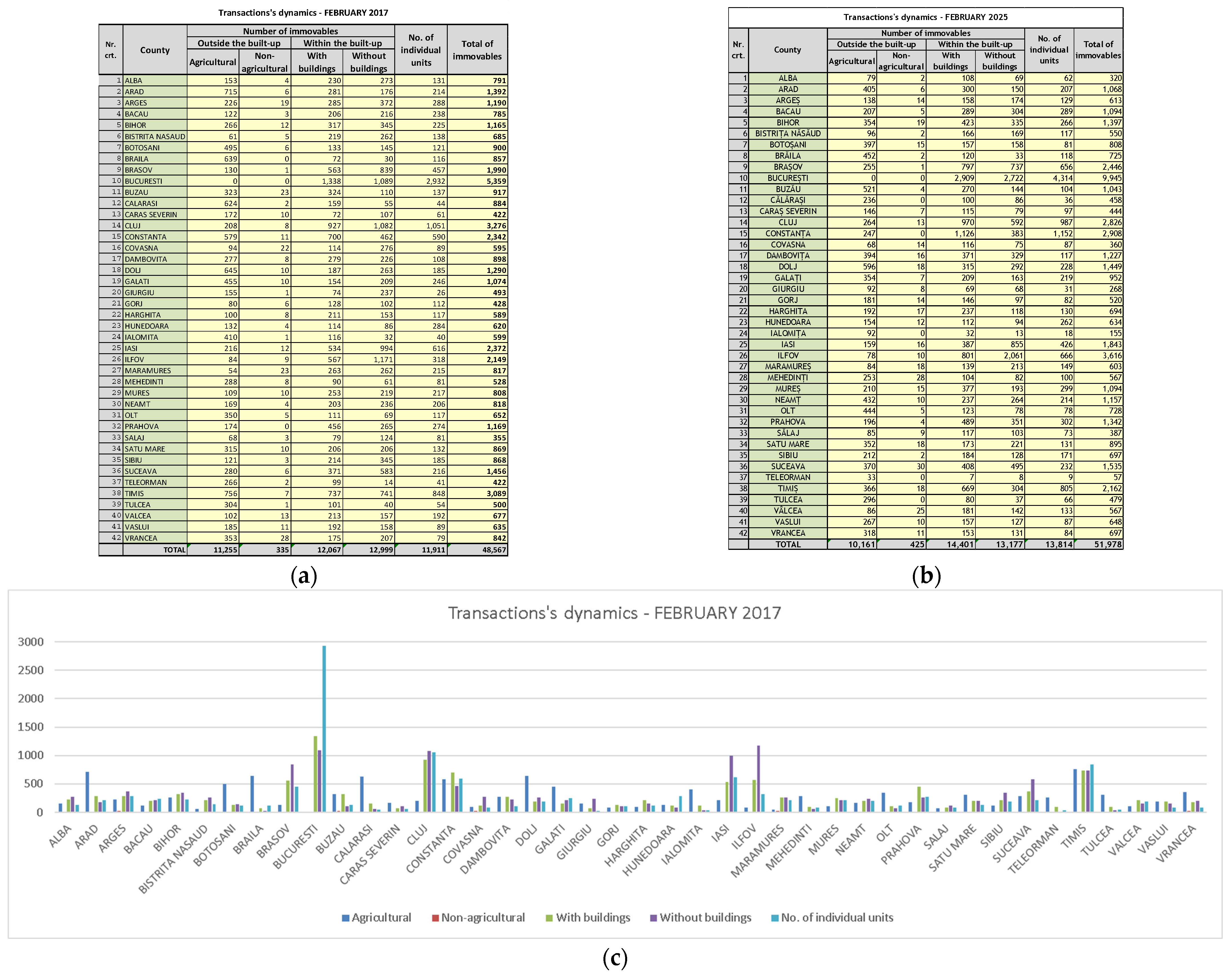
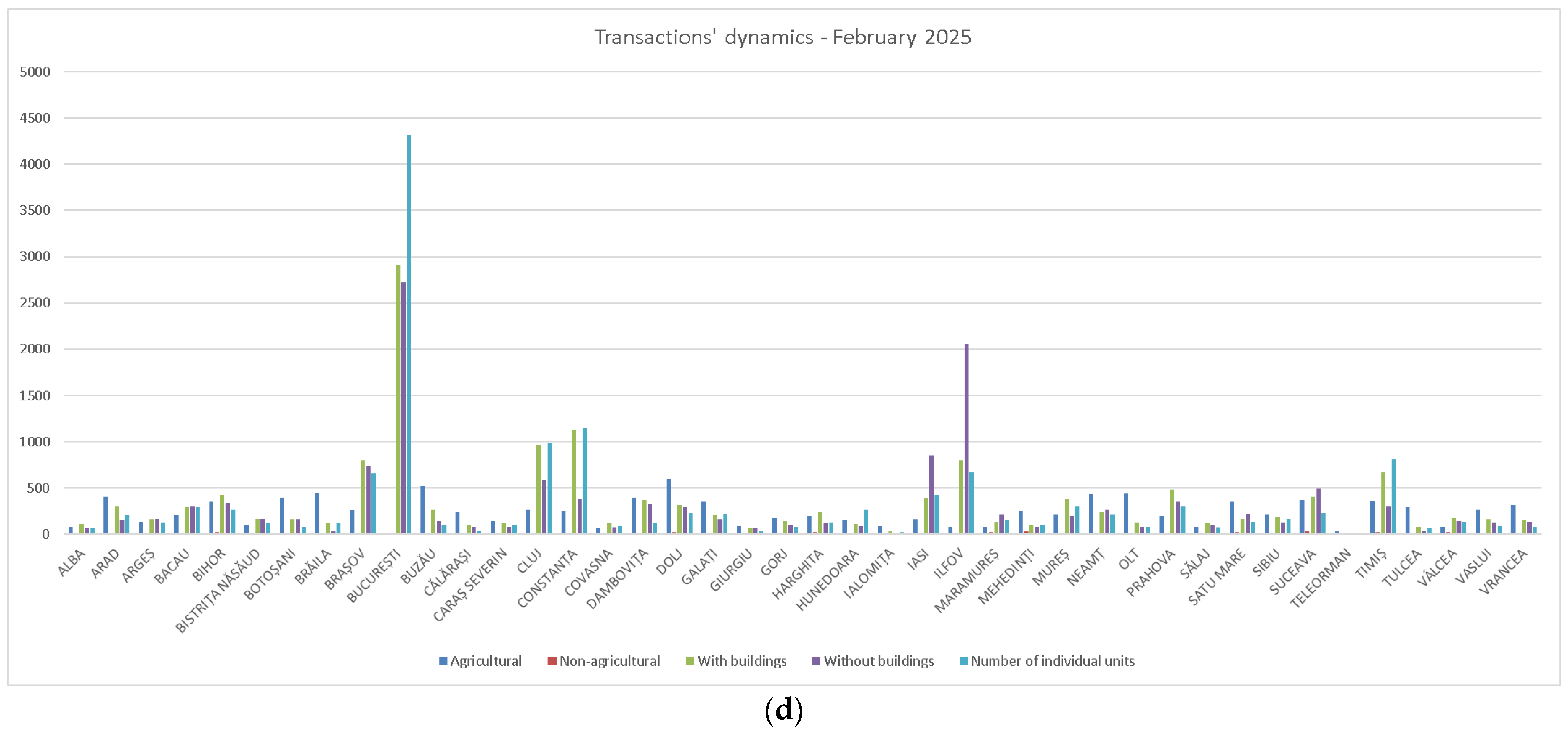
A complete and updated cadastral database allows for the accurate valuation of properties, which attracts investors and improves access to bank financing. Financial institutions can utilize cadastral data to reduce lending risk, as real estate collateral is easier to assess and track. For example, systematic cadastral registration eliminates the need for individual property title rectifications, accelerating mortgage processes. The enhancement of cadastral data quality and the implementation of the PNCCF (National Program of Cadastre and Land Registration) have been crucial factors in the modernization and dynamization of the Romanian real estate market. By ensuring legal security, facilitating transactions, stimulating investments, and improving administration, these have significantly contributed to the development of a more transparent, efficient, and secure real estate sector leading to the increase in the transactions’ dynamics in 2025 as compared to previous years—the early stage of PNCCF implementation (
Figure 1).
2.3. Socio-Economic Benefits and Sectorial Impact
Optimization of taxation and urban and rural planning
Cadastral data provides authorities with a factual basis for calculating taxes and eliminating discrepancies caused by incomplete records. The availability of accurate spatial and legal data strengthens fiscal equity, improves revenue collection at the local level, and supports public budget planning. Additionally, systematic land registration supports urban and rural planning by identifying areas available for development and ensuring coherent land management. Up-to-date cadastral maps help local administrations align infrastructure investments with real land use, reducing planning errors.
Sustainable and efficient development of the agricultural sector
Systematic land registration plays a crucial role in the agricultural sector, offering a range of essential benefits regarding the clarification of property rights, facilitating transactions and access to financing, optimizing land use, supporting agricultural policies, and modernizing agriculture [
22]. A reliable cadastral system allows for better monitoring of agricultural subsidies, control of land fragmentation [
5], and development of digital farming systems.
This study emphasizes the importance of systematic property registration in rural development in Romania, in terms of advantages it can bring. In particular, the clarification of ownership rights and the legal security of transactions are foundational for agricultural investment, farm consolidation, and access to EU funding.
A review of existing research highlights the complex interplay between the social and economic aspects of agriculture. The sector’s influence, both at the individual farm and national levels, impacts crucial factors like employment, poverty, productivity, income, and overall economic output, ultimately shaping rural development. However, empirical evidence suggests that prioritizing economic and social sustainability in agriculture can come at the expense of environmental sustainability [
23]. This trade-off highlights the need for integrated land governance approaches that balance economic growth with environmental protection.
Challenges and recent improvements
Although only 86 out of over 3000 localities had completed systematic land registration by 2021, the 2024 reforms introduced simplifications to accelerate the process (
Figure 2). These include clarifying regulatory terms, monitoring service providers through work schedules, and involving specialists in document verification. In addition, the implementation of automated quality control mechanisms and standardized approval procedures for orthophotoplans through the CNC (National Centre for Cadastre and Land Registration) represents key advancements.
Impact on the Real Estate market
Systematic registration transforms the real estate market [
25] into a more predictable environment, reducing property-related uncertainties and encouraging transactions. The resulting legal certainty fosters investor confidence, simplifies property transfers, and aligns the Romanian land system with EU requirements [
26]. Although implementation (
Figure 3) is slow, the long-term benefits include increased investor confidence, streamlined administration, and alignment with European standards.
2.4. Technical and Legal Framework of Cadastre Implementation
To achieve this goal, the National Agency for Cadastre and Land Registration has issued several regulations and orders that define the framework and stages of implementing the cadastre in Romania, as follows:
The tender documents for cadastre contracts include detailed requirements for the following:
Work methodologies (e.g., the use of global positioning systems—GPS/GNSS and any other suitable geodetic method of measurements);
Document format (cadastral plans, land book extracts, verification minutes);
Execution deadlines and quality criteria.
Workflow structure and legal basis (
Table 1)
The table below summarizes the procedural stages and their legal references.
Amendments made by Order 430/2022 [
31] have consolidated the role of OCPI in coordinating activities at the local level, emphasizing the need for collaboration with local authorities to streamline the systematic registration process.
This procedural structure ensures compliance with legal requirements and standardizes cadastral practices at the national level, contributing to the integrity of the land registration system. Reception of technical cadastral documents, the final copy for the cadastral sector, related to the built-up area is shown in
Figure 4.
3. Research Methodology
This study adopts a qualitative and document-based research approach, focusing on the analysis of legislative frameworks, institutional procedures, and technical instruments used in systematic land registration in Romania. The primary sources include national laws, governmental orders (e.g., Law No. 18/1991, Law No. 7/1996, ANCPI regulations), reports from the National Cadastre and Land Registration Agency (ANCPI), and scientific publications in the fields of land administration and GIS. Secondary sources consist of academic literature and publicly available data sets regarding cadastral progress and rural development indicators.
The chosen methodology—combining qualitative analysis, the literature review, and practical case integration [
32,
33]—is particularly suitable for this research because it addresses a complex, multi-layered issue. It enables an in-depth understanding of systemic weaknesses and technical opportunities in cadastral implementation by triangulating legislative, institutional, and technological perspectives. Furthermore, it allows for a contextual interpretation of policy and implementation barriers that would not emerge through purely quantitative or survey-based methods.
The analysis included a comparative legal review of cadastral legislation across Romania’s historical regions and a thematic synthesis of relevant policy documents, implementation reports, and regulatory frameworks, in order to identify patterns, gaps, and institutional constraints. A descriptive evaluation of technological integration (GIS, UAV, GNSS) was conducted based on use-case scenarios and practical applications documented in recent national projects. To illustrate the experiential dimension of the study, a documented implementation in Arad County was included as a representative use-case, enabling the contextual analysis of cadastral workflows and technological integration within a real administrative-territorial unit. The criteria for choosing this case study are based on the facts that data availability in this area is relatively high, and this case can better demonstrate the integrated application of GIS/UAV technology. The county is in the top 5 for the number of registered properties, as can be seen in the graph in
Figure 5 showing the situation of Romania’s counties as regards the number of systematic properties registered at the end of the year 2023.
The methodological framework is also informed by the principles of the Fit-for-Purpose Land Administration model, promoted by UN-Habitat and the World Bank. While the research does not include primary data collection such as interviews or surveys, the study integrates multiple layers of qualitative analysis to ensure triangulation and reliability of conclusions. Future empirical validation could include pilot assessments in selected administrative units to corroborate the efficiency and socio-economic impact of systematic registration. Potential future extensions may include empirical case studies in selected localities to assess on-the-ground effects of registration efforts, particularly in terms of socio-economic outcomes, stakeholder perception, and institutional performance.
4. Results
This section presents the technical results of implementing systematic cadastral registration in Romania, with a particular focus on geospatial integration, UAV technologies, and data processing methodologies. The results reflect real-case applications and the operational effectiveness of GIS-based cadastral workflows.
Contemporary cadastral practice, beyond the completion of systematic cadastral surveys and land book establishment, emphasizes the development of a GIS database encompassing all information and data pertinent to properties registered within the newly created land books.
4.1. GIS Technology and UAV Integration in Cadastre
A GIS-based approach necessitates the seamless integration of graphical, cartographic, topological, and tabular data into a unified, non-redundant database. The integration of spatial and attribute data enables complex spatial analysis, efficient querying, and improved visualization of land-related information. While computer graphics are integral to the system, they represent but one modality for accessing and reporting the content of the spatial database. The database itself allows for exploration through diverse processing and analytical techniques grounded in geographical and analytical criteria.
A GIS incorporates a suite of spatial operators acting upon the database to geographically represent a broad spectrum of real-world information. Within a cadastral context, each spatial feature (parcel, building, boundary) is timestamped and linked to its legal documentation, ensuring traceability and historical record integrity. The inherent complexity of the GIS data model stems from the necessity to integrate and interlink both graphical (map) and tabular (attribute) data. Within the real estate cadastre database, each spatial object is associated with temporal metadata, specifically creation and archiving timestamps, delineating the object’s lifecycle. Furthermore, subsequent versions of each object are also timestamped for creation and archiving, and each object is linked to the identifier of its spatial information infrastructure [
34].
Furthermore, advanced GIS platforms are employed to simulate complex real-world situations and events, thus demanding an enhanced capacity of the model to accurately replicate real-world phenomena and occurrences.
Synergy between human expertise and GIS technology is a systemic approach which is based on interdisciplinarity as the foundation of GIS competencies.
GIS specialists operate at the intersection of four fundamental epistemological domains, according to the requirements identifiable in practical implementations (
Figure 6):
Geography and geomatics—interpretation of spatio-temporal processes and integration of LiDAR/UAV data;
Software engineering—development of algorithms for predictive analysis and workflow automation;
Advanced statistics—application of spatial regression models and georeferenced significance tests;
Specific application domain—adaptation of solutions to sectoral requirements (e.g., hydrological risk modeling in land reclamation.
This disciplinary convergence enables the creation of hybrid cognitive models, where raw data are transformed into actionable strategies through interpretive filters specific to each domain.
The role of the human operator in the GIS value chain is particularly important and is centralized in the following transformation stages (see
Table 2).
For example, case studies of transport networks demonstrate that real-time traffic interpretation requires the following:
Error analysis in GIS projects shows that most inconsistencies result from data input issues (see
Table 3) and poor interdisciplinary communication:
Data labeling errors in the collection phase;
Overinterpretation of statistical results without geographical context;
Lack of synchronization between software updates and operator training.
Solutions proposed in the scientific literature include the following:
Expert systems with adaptive interfaces based on user competency level;
Cascade validation procedures involving experts from related domains;
Predictive simulations for scenario testing in controlled conditions.
All this information makes Romania’s cadastral statistical and graphical data available to both domestic users (investment strategies) and the general public. Transparency of cadastral data enhances public trust and supports decision-making across governmental, financial, and civil sectors.
4.2. Implementation Example
To exemplify data collection and its integration into the general cadastre system, a systematic registration workflow in a locality in western Romania, Arad County, is described below. The process included data collection on field, processing, registration, and publication. Although no law stipulates which method should be used for identifying property boundaries, for high precision, on-site measurements overlaid with orthophotoplan geometrization were carried out. It is emphasized that the orthophotoplan was used as a primary visual source for identifying and delimiting the boundaries of existing parcels, especially in the context of systematic registration where a large number of properties need to be mapped in a relatively short time. However, it was not used as the sole and definitive source for the legal establishment of property boundaries, which remains based on existing ownership documents and additional on field measurements.
The implementation of Unmanned Aerial Systems (UASs) in generating orthophotoplans represents a significant innovation in the field of cartography and geospatial data analysis [
35]. Drones equipped with high-performance cameras have been used as they offer an efficient and cost-effective solution for capturing high-resolution aerial images (
Figure 7), essential for obtaining accurate cartographic products such as the Digital Elevation Model of the surveyed area (
Figure 8). This process combines GNSS technology, advanced photogrammetry, and specialized software to create precise digital models.
As can be observed in
Figure 9, the determination errors of the Ground Control Points (GCPs) are around 5 cm per GCP. However, the proposed parcel delimitation must take into account the areas recorded in the cadastral registers and, in some cases, the areas in the land book. For this purpose, the areas of the land blocks and the administrative-territorial unit were determined using GNSS technology. With these components, it was possible to define the parcel boundaries to track the constraints assumed by the service providers and required by the national cadastre agency.
Studies have been made demonstrating that a large image overlap, as well as a cross-flight pattern, increases the accuracy and completeness of automatically delineated walls. These studies also analyzed the influence of the number of Ground Control Points (GCPs). It can be concluded that the main advantage of using a UAS (Unmanned Aerial System) for geodetic topography remains the ability to collect a large amount of data in a short period of time compared to classic topography methods, through non-invasive methods which are much safer because they do not require the effective presence of the operator in places with potential danger on the construction site [
36].
Through the integration of topographic surveys (
Figure 10), existing cadastral plans, and the generated orthophotoplans and 3D Models, a rigorous verification of cadastral elements was conducted, facilitating the precise identification of properties within the area. Topographic surveys provide accurate data regarding the position and contour of land parcels, while existing plans furnish historical and documented information concerning property configuration and structure. The orthophoto, derived from processed aerial imagery, introduces an element of currency and enhanced accuracy, rectifying potential errors stemming from non-uniform perspectives or optical distortions.
In Romania, according to EU regulations, the authority that administrates agricultural land has clear milestones to integrate the cadastre, so these kinds of approaches, which imply integrating modern technologies for data acquisition correlated with legal documentation, are essential in the cadastre implementation process.
This integrated approach ensures the precise identification of each property and the establishment of its boundaries (
Figure 11) in accordance with the ownership documents held by the owners. Consequently, a correlation is achieved between field-derived data and legal documentation, guaranteeing that cadastral delimitations faithfully reflect the existing reality and property rights. The automated process can be observed on one hand, and on the other hand, how this data are validated by the inspector and subsequently published.
The outcome is an updated and reliable cadastral record (
Figure 12), essential for urban planning, resource management, and the resolution of potential boundary disputes.
Following the implementation of these workflow refinements, notable advancements are evident across the modalities of geospatial data acquisition, processing, and storage, leading to enhanced efficiency and reduced processing times for cadastral information. Simultaneously, the reception of cadastral documentation is undergoing a process of progressive automation, minimizing manual intervention and potential for human error in the initial stages of data ingestion. As substantiated by the quantitative trajectory depicted in the cadastre and land registration implementation timeline, a significant increase in the volume of properties registered within the Land Book has been observed (
Figure 13), indicating a direct positive correlation between the optimized workflows and the accelerated rate of land registration (
Figure 14), ultimately contributing to a more comprehensive and reliable national cadastral database.
Overall, the technical implementation of GIS and UAV systems in Romania’s cadastre program demonstrates operational efficiency, particularly in counties such as Arad and Timiș. However, the pace of adoption remains uneven across the country [
3], largely influenced by institutional capacity and the availability of legacy property documentation. These findings provide a factual basis for the broader analysis presented in the next section.
5. Discussion
While the technical and procedural outcomes of systematic cadastral implementation in Romania are increasingly robust and measurable, they reveal only part of the picture. A comprehensive understanding of this national reform effort requires examining the broader legal, historical, and socio-economic dimensions that critically shape its effectiveness and long-term sustainability. Despite recent legislative reforms and the gradual digitization of cadastral workflows, the legal framework governing land ownership remains fragmented due to Romania’s diverse historical legacies. In western regions such as Transylvania and Banat, property records and cadastral practices were shaped by Austro-Hungarian law, resulting in more coherent documentation and administrative efficiency. In contrast, Moldova, Wallachia, and Dobrogea—regions influenced by Ottoman and Byzantine legal traditions—suffer from weaker property documentation, widespread ownership disputes, and slower institutional adaptation. These legal–historical discrepancies continue to obstruct a unified national approach to cadastre modernization [
37]. Moreover, socio-economic disparities amplify the difficulties of implementation. Many rural areas lack the financial and technical capacity to manage or benefit fully from cadastral programs. Public awareness remains limited, particularly in regions where local authorities are under-resourced and institutional trust is low. In these contexts, inheritance disputes, informal land use, and limited digital literacy significantly delay or discourage registration [
38]. These factors risk reinforcing territorial inequality, as communities already marginalized are further excluded from the legal and financial benefits of formal land tenure.
The experience of other post-socialist states underscores the importance of tailoring cadastre reforms to national realities. As demonstrated in Poland, the Czech Republic, and Bulgaria, success has depended on strategic coordination between central institutions and local stakeholders, supported by strong legal guarantees and public engagement [
39,
40]. These countries have also emphasized the role of public participation and local governance in improving both the speed and reliability of cadastral integration. Romania’s path forward requires a similar multidimensional strategy—one that includes legal harmonization, simplified procedures, citizen outreach, and capacity-building at the local level. Finally, the need for adaptive and context-sensitive land administration models has been widely acknowledged in the literature. The “fit-for-purpose” land administration framework proposed by UN-Habitat and the World Bank highlights the importance of flexibility, affordability, and rapid implementation in cadastral reform [
41]. Romania’s adoption of such principles—while still partial—could help reconcile national cadastral objectives with the country’s historical and institutional complexity. Ultimately, systematic cadastre must be seen not merely as a technical project, but as a governance reform with long-term social, legal, and economic implications. A fair and efficient registration system will enable better access to credit, reduce litigation, and promote equitable development. However, achieving these goals demands more than technological solutions: it requires sustained political will, inter-institutional coordination, and a policy framework that prioritizes inclusiveness and regional adaptability.
6. Conclusions
The establishment of a GIS database at the administrative unit level offers significant advantages for data query processes. Through queries, users can rapidly access relevant information and visualize it on a map for enhanced spatial context comprehension. A well-structured GIS supports spatial intelligence, enabling public institutions, planners, and investors to make informed decisions based on accurate geospatial and legal data Within a comprehensive and sophisticated GIS database, queries enable the expeditious extraction of pertinent data, such as public and private property attributes, land use categories, and building elevation levels.
Within the Geographic Information System developed by the National Agency for Cadastre and Land Registration, which records and manages all cadastral and property data in Romania, various spatial analysis and geoprocessing methodologies can be employed to provide a comprehensive overview of available opportunities. These analytical methods facilitate the acquisition of answers to fundamental inquiries such as ‘What?’, ‘Where?’, ‘How much?’, and ‘When?’, and contribute to the identification of solutions for investigated problems. GIS layers are designed to streamline the selection of relevant information, thereby supporting the generation of predictions and the explanation of phenomena from a geographical distribution perspective. At the same time, the used system is continuously developing and facilitates a more precise valuation of properties by considering factors such as location, size, land characteristics, and infrastructure accessibility. This ensures transparent and fair real estate transactions and supports fiscal accuracy by preventing the overvaluation or undervaluation of properties.
The proposed solution offers significant benefits in the analytical domain as well. Through advanced spatial analysis tools, specialists can identify relationships between various cadastral elements, detect patterns, and perform complex queries to evaluate the impact of both urban and rural development projects or environmental policies. This analytical capacity enhances strategic planning, enabling authorities to prioritize investments, manage land resources efficiently, and mitigate potential risks. For instance, the analysis of spatial distribution of properties and the identification of areas with development potential or environmental risks can be performed much faster and more accurately than through traditional methods.
The streamlining of cadastral processes represents another crucial aspect facilitated by GIS integration. The automation of workflows, coupled with the capacity to customize operations through scripting and other processing technologies, significantly reduces the time required for data collection and validation. This results in reduced administrative burden, lower operational costs, and increased responsiveness of institutions to changes in the field. Furthermore, the interoperability of GIS systems with other information platforms ensures seamless collaboration between various departments and institutions, ranging from local administration to national cadastral agencies.
Moreover, the long-term success of systematic cadastral registration in Romania hinges not only on technological advancements and procedural efficiency, but also on the ability of institutions to adapt to regional legal diversity, address social barriers to participation, and build public trust. Future efforts must integrate legal harmonization, inclusive governance, and empirical evaluation of regional disparities to ensure that cadastral modernization translates into tangible socio-economic benefits across all communities. In conclusion, the integration of geospatial technologies, legal frameworks, and institutional coordination is essential for achieving efficient land governance and supporting sustainable development in Romania.
However, several limitations remain that should be addressed in future work to improve the effectiveness and inclusiveness of the cadastre system. First, the absence of detailed, empirical case studies limits the understanding of how systematic registration functions at the local level, particularly in rural or underdeveloped areas. Second, the study focuses predominantly on Romania, without extensive comparison to other post-socialist or EU countries implementing similar cadastral reforms. Third, the social and cultural factors that may hinder adoption—such as lack of awareness, mistrust of institutions, or inheritance disputes—are not explored in depth. Future research should incorporate field studies, citizen perspectives, and comparative international experiences to provide a more holistic view of land governance reform.
Author Contributions
Conceptualization, V.G., C.G., C.-B.V., S.H. and C.C.; methodology, V.G., C.G., C.-B.V., S.H. and C.C.; software, S.H.; validation, C.G., C.-B.V. and S.H.; formal analysis, C.G., C.-B.V. and S.H.; investigation, C.G., C.-B.V. and S.H.; resources, C.G., C.-B.V. and S.H.; data curation, C.G., C.-B.V. and S.H.; writing—original draft preparation, V.G., C.G., C.-B.V., S.H. and C.C.; writing—review and editing, V.G., C.G., C.-B.V., S.H. and C.C.; visualization, C.G., C.-B.V. and S.H.; supervision, V.G., C.-B.V., S.H. and C.C. All authors have read and agreed to the published version of the manuscript.
Funding
This research received no external funding.
Data Availability Statement
The original contributions presented in this study are included in the article. Further inquiries can be directed to the corresponding author.
Conflicts of Interest
The authors declare no conflict of interest.
References
- Vilceanu, C.B.; Herban, S.; Alionescu, A. Using Open Source GIS for the Management of the Administrative Territorial Unit. In Proceedings of the Modern Technologies for the 3rd Millennium; Nistor, S., Popoviciu, G., Eds.; Editografica s.r.l.: Bologna, Italy, 2016; pp. 73–78. [Google Scholar]
- LEGE 18 19/02/1991—Portal Legislativ. Available online: https://legislatie.just.ro/Public/DetaliiDocument/1459 (accessed on 12 April 2025).
- Păunescu, V.; Iliescu, A.I.; Călin, M.C.; Sălăgean, T.; Kohli, D.; Nap, M.-E.; Șuba, E.-E. A Quality Assessment of the Romanian National Program of Systematic Land Registration the Point of View of Local Cadastral Offices Directors. Surv. Rev. 2024, 56, 284–299. [Google Scholar] [CrossRef]
- Radu, O. Realization of the Systematic Cadastrum in Romania. 2022. Available online: https://repository.iuls.ro/xmlui/handle/20.500.12811/3423 (accessed on 1 May 2025).
- Savoiu, C.; Lemmen, C.; Savoiu, I. Systematic Registration in Romania: A New Opportunity for Land Consolidation. In From the Wisdom of the Ages to the Challenges of the Modern World: Proceedings of FIG Working Week, 17–21 May 2015; International Federation of Surveyors (FIG): Copenhagen, Denmark, 2015. [Google Scholar]
- Constantin, M.C.; Beatrice, V.C.; Maria, M.A. Systematic Registration of Properties—A New Challenge for Romanian Cadastral System. Journal of Geodesy, Cartography and Cadastre, pp. 15–20. 2015. Available online: https://www.jgcc.geoprevi.ro/docs/2015/3/jgcc_2015_no3_3.pdf (accessed on 10 May 2025).
- Grecea, C.; Rusu, G.; Mușat, C.; Moscovici, A.M. Challenges in Implementing the Systematic Land Registration in Romania. In Recent Advances in Geodesy and Geomatics Engineering, Proceedings of the 1st European Conference of Geodesy & Geomatics Engineering GENG’13, Antalya, Turkey, 8–10 October 2013; ISBN 978-960-474-335-3. ISSN 2227-4359. pp. 98–105, Available online: https://www.academia.edu/69122122/Challenges_in_implementing_the_systematic_land_registration_in_Romania; (accessed on 10 April 2025).
- Copăcean, L.; Man, E.T.; Cojocariu, L.L.; Popescu, C.A.; Vîlceanu, C.-B.; Beilicci, R.; Creţan, A.; Herbei, M.V.; Cuzic, O.Ş.; Herban, S. GIS-Based Flood Assessment Using Hydraulic Modeling and Open Source Data: An Example of Application. Appl. Sci. 2025, 15, 2520. [Google Scholar] [CrossRef]
- LEGE 10 18/01/1995—Portal Legislativ. Available online: https://legislatie.just.ro/Public/DetaliiDocument/5729 (accessed on 12 April 2025).
- LEGE 50 29/07/1991—Portal Legislativ. Available online: https://legislatie.just.ro/Public/DetaliiDocumentAfis/1515 (accessed on 12 April 2025).
- LEGE 350 06/07/2001—Portal Legislativ. Available online: https://legislatie.just.ro/public/detaliidocument/29453 (accessed on 12 April 2025).
- LEGE 1 11/01/2000—Portal Legislativ. Available online: https://legislatie.just.ro/Public/DetaliiDocument/20557 (accessed on 12 April 2025).
- LEGE 10 08/02/2001—Portal Legislativ. Available online: https://legislatie.just.ro/Public/DetaliiDocument/26680 (accessed on 12 April 2025).
- LEGE 165 16/05/2013—Portal Legislativ. Available online: https://legislatie.just.ro/Public/DetaliiDocument/147937 (accessed on 12 April 2025).
- LEGE 247 19/07/2005—Portal Legislativ. Available online: https://legislatie.just.ro/Public/DetaliiDocumentAfis/63447 (accessed on 12 April 2025).
- LEGE 17 07/03/2014—Portal Legislativ. Available online: https://legislatie.just.ro/Public/DetaliiDocument/156290 (accessed on 12 April 2025).
- LEGE (R) 7 13/03/1996—Portal Legislativ. Available online: https://legislatie.just.ro/Public/DetaliiDocument/69491 (accessed on 12 April 2025).
- LEGE 312 10/11/2005—Portal Legislativ. Available online: https://legislatie.just.ro/Public/DetaliiDocument/65858 (accessed on 12 April 2025).
- Herban, S.; Grecea, C.; Muşat, C.; Vîlceanu, C. Workflow Optimization of Immovable’s Registration in Romanian Cadastral System. Int. Multidiscip. Sci. GeoConference SGEM 2015, 2, 1231–1238. [Google Scholar]
- Păunescu, V.; Kohli, D.; Iliescu, A.-I.; Nap, M.-E.; Șuba, E.-E.; Sălăgean, T. An Evaluation of the National Program of Systematic Land Registration in Romania Using the Fit for Purpose Spatial Framework Principles. Land 2022, 11, 1502. [Google Scholar] [CrossRef]
- Grecea, C.; Moscovici, A.-M.; Vilceanu, C.-B.; Herban, S. Comparative overview of cadastre and land information systems in some countries from Europe-an efficient tool to understand and manage urban development. J. Environ. Prot. Ecol. 2014, 15, 678–685. [Google Scholar]
- Morărescu, A.; Herban, S.; Vilceanu, C.-B.; Grecea, D. Durable Solutions for Precision Agriculture in Romania; AIP Publishing: Melville, NY, USA, 2020; Volume 2293. [Google Scholar]
- Herman, E. Sustainable Agriculture and Its Impact on the Rural Development in EU Countries: A Multivariate Analysis. Land 2024, 13, 947. [Google Scholar] [CrossRef]
- NOTA Privind Activitatea ANCPI La Data de 31.03.2025.Pdf. Available online: https://www.ancpi.ro/pnccf/documente/NOTA%20privind%20activitatea%20ANCPI%20la%20data%20de%2031.03.2025.pdf (accessed on 12 April 2025).
- Raboj, D.; Badea, G.; Badea, A.C. Importance of the Market Value of Real Estates in Cadastral Registration. Int. Multidiscip. Sci. GeoConference SGEM 2016, 3, 279–286. [Google Scholar]
- Badea, A.-C.; Badea, G.; Vasilca, D.; Semen, C. Advantages of the European Knowledge of Real Estate Regulations and Data. Int. Multidiscip. Sci. GeoConference SGEM 2016, 2, 53–60. [Google Scholar]
- Stadiul PNCCF La 31-03-2025—Lucrări de Înregistrare Sistematică a Imobilelor În Derulare La Nivel de Sector Cadastral. Available online: https://www.ancpi.ro/pnccf/documente/H2%20-%20Lucrari%20%20in%20derulare%20la%20nivel%20de%20sector%20cadastral.pdf (accessed on 12 April 2025).
- ORDIN 1 07/01/2020—Portal Legislativ. Available online: https://legislatie.just.ro/Public/DetaliiDocument/222509 (accessed on 12 April 2025).
- Monitorul Oficial. Apariții și Abonamente; Monitorul Oficial al României: București, Romania, 2025. [Google Scholar]
- Oficial, R.M. Acte Publicate în Monitorul Oficial, Partea I; Monitorul Oficial al României: București, Romania, 2025. [Google Scholar]
- ProLege, R. Regulamentul Privind Realizarea, Verificarea şi Recepţia Lucrărilor Sistematice de Cadastru şi Înscrierea din Oficiu a Imobilelor în Cartea Funciară–Modificări (ODGANCPI nr. 430/2022); Universul Juridic: Bucharest, Romania, 2022. [Google Scholar]
- Ghergar, A.; Madăra, R.; Popescu, G.; Dragomir, L. Aplication of Modern Measurement Technologies in the Process of Sistematic Registration of Real Estate. Res. J. Agric. Sci. 2023, 55. [Google Scholar]
- Bancioiu, R.; Kovacs, L. The Systematic Registration of Property Law and Cadastre on the Territory in Romania: Discussing a Case Study. Nova Geod. 2022, 2, 28. [Google Scholar] [CrossRef]
- Grzelka, K.; Pargieła, K.; Jasińska, A.; Warchoł, A.; Bydłosz, J. Registration of Objects for 3D Cadastre: An Integrated Approach. Land 2024, 13, 2070. [Google Scholar] [CrossRef]
- Sestras, P.; Badea, G.; Badea, A.C.; Salagean, T.; Roșca, S.; Kader, S.; Remondino, F. Land Surveying with UAV Photogrammetry and LiDAR for Optimal Building Planning. Autom. Constr. 2025, 173, 106092. [Google Scholar] [CrossRef]
- Naș, S.M.; Bondrea, M.V.; Rădulescu, V.M.; Gâlgău, R.; Vereș, I.S.; Bondrea, R.; Rădulescu, A.T. The Use of UAVs for Land Use Planning of Brownfield Regeneration Projects-Case Study: Former Brick Factory, Cluj Napoca, Romania. Land 2023, 12, 315. [Google Scholar] [CrossRef]
- Williamson, I.; Enemark, S.; Wallace, J.; Rajabifard, A. Land Administration for Sustainable Development, 1st ed.; Williamson, I.P., Ed.; ESRI Press Academic: Redlands, CA, USA, 2010; ISBN 978-1-58948-041-4. [Google Scholar]
- Good Governance in Land Tenure and Administration. Available online: https://openknowledge.fao.org/server/api/core/bitstreams/7c41abf6-7f7d-469e-ba6b-709dc4299d42/content/a1179e.htm (accessed on 6 May 2025).
- Polat, Z.A.; Ustuner, M.; Alkan, M. On the Way to Vision of Cadastre 2034: Cadastre 2014 Performance of Turkey; FIG working week: Sofia, Bulgaria, 2015. [Google Scholar]
- Fit-For-Purpose Land Administration: Guiding Principles for Country Implementation|UN-Habitat. Available online: https://unhabitat.org/fit-for-purpose-land-administration-guiding-principles-for-country-implementation (accessed on 6 May 2025).
- Enemark, S. Fit-For-Purpose Land Administration: Joint FIG/World Bank Publication; FIG: Copenhagen, Denmark, 2014; ISBN 978-87-92853-10-3. [Google Scholar]
| Disclaimer/Publisher’s Note: The statements, opinions and data contained in all publications are solely those of the individual author(s) and contributor(s) and not of MDPI and/or the editor(s). MDPI and/or the editor(s) disclaim responsibility for any injury to people or property resulting from any ideas, methods, instructions or products referred to in the content. |
© 2025 by the authors. Licensee MDPI, Basel, Switzerland. This article is an open access article distributed under the terms and conditions of the Creative Commons Attribution (CC BY) license (https://creativecommons.org/licenses/by/4.0/).

_Cheung.jpeg)

 ,
, 


