Using Multi-Criteria Analysis for Urban Planning: Selection of Municipal Units in Which to Conduct Studies of Development Rights’ Transfer Zones (RTZs) in Greece
Abstract
1. Introduction
2. Transfer of Development Rights in Greece
3. Materials and Methods
3.1. Methodology
- Land parcels that are expropriated for public space or public facilities;
- Land parcels with restrictions for the protection of architecture or natural heritage;
- Land parcels where construction restrictions are imposed due to regulations on archaeological and cultural protection, including archaeological sites and historic places.
- Within areas where the urban planning process started with a regulatory act or within approved settlement boundaries;
- Outside historic places, traditional settlements, archaeological sites, or areas where construction limitations are applied for the protection of traditional architecture, archaeological sites, and sites with significant cultural or environmental characteristics;
- Outside historical centres;
- Outside protected areas;
- Outside the first two blocks from the shoreline;
- Outside blocks where the slope is greater than 25%;
- Outside blocks that are neighbouring forest areas.
- Prevalent land use is other than for residence, so that the potential increase of building rights shall not lead to a significant population increase, thus stretching the demands on infrastructure and utilities;
- Are areas of production activities;
- Are areas that are designated for urban plan extension;
- Are pure residential areas of low building density in which a potential increase will not degrade quality of life;
- Are urban renewal areas.
3.2. Objectives
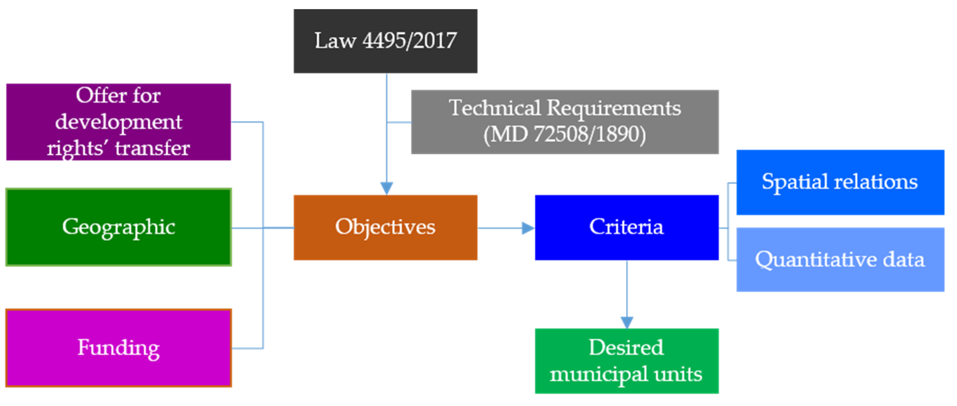
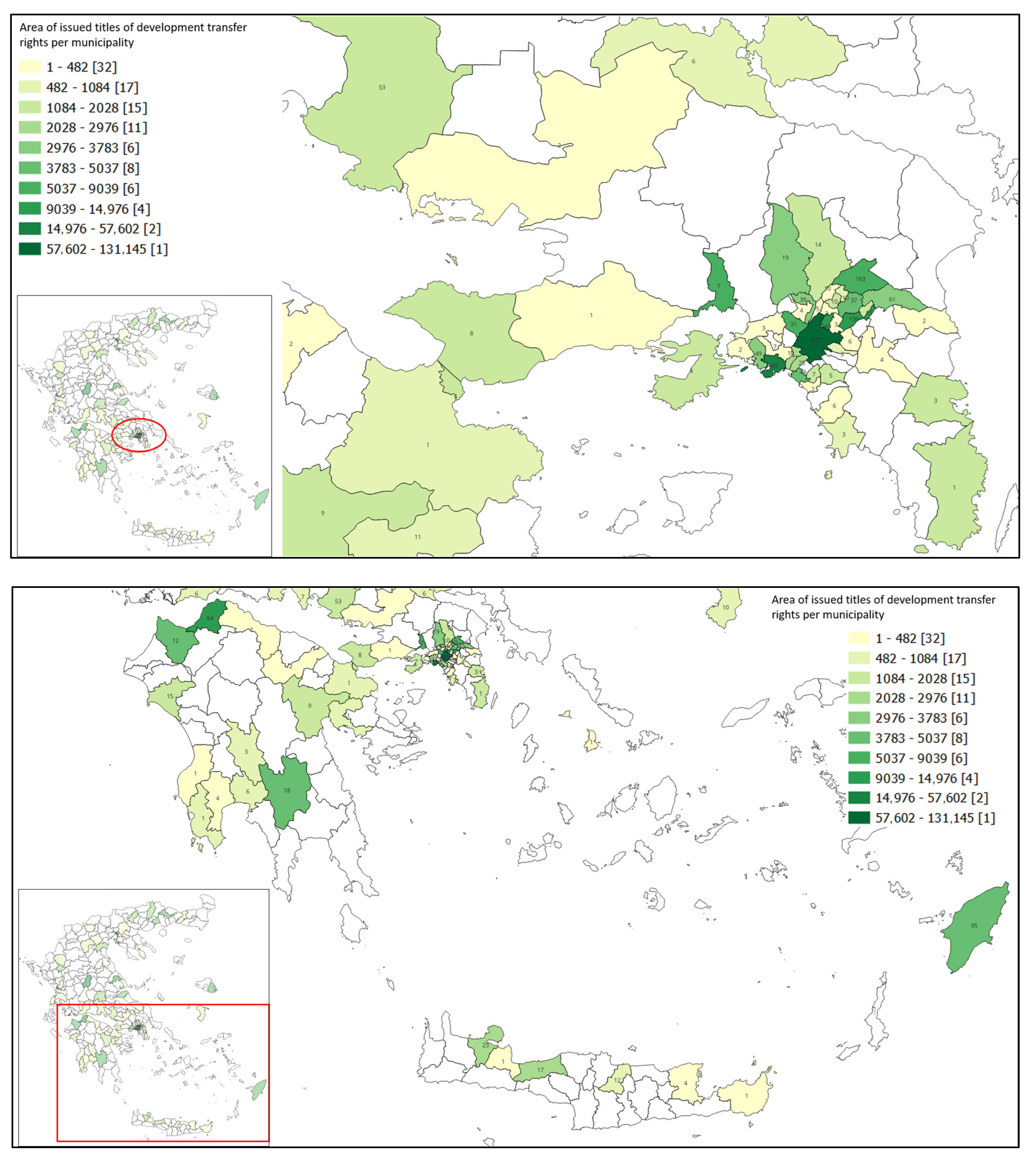
- The quantity of encumbered parcels and of non-materialised titles of development rights’ transfer: This objective relates to the definition of the municipal units that will be investigated for the development of RTZs, based on the number of parcels with listed buildings and the number of issued titles of development rights’ transfer.
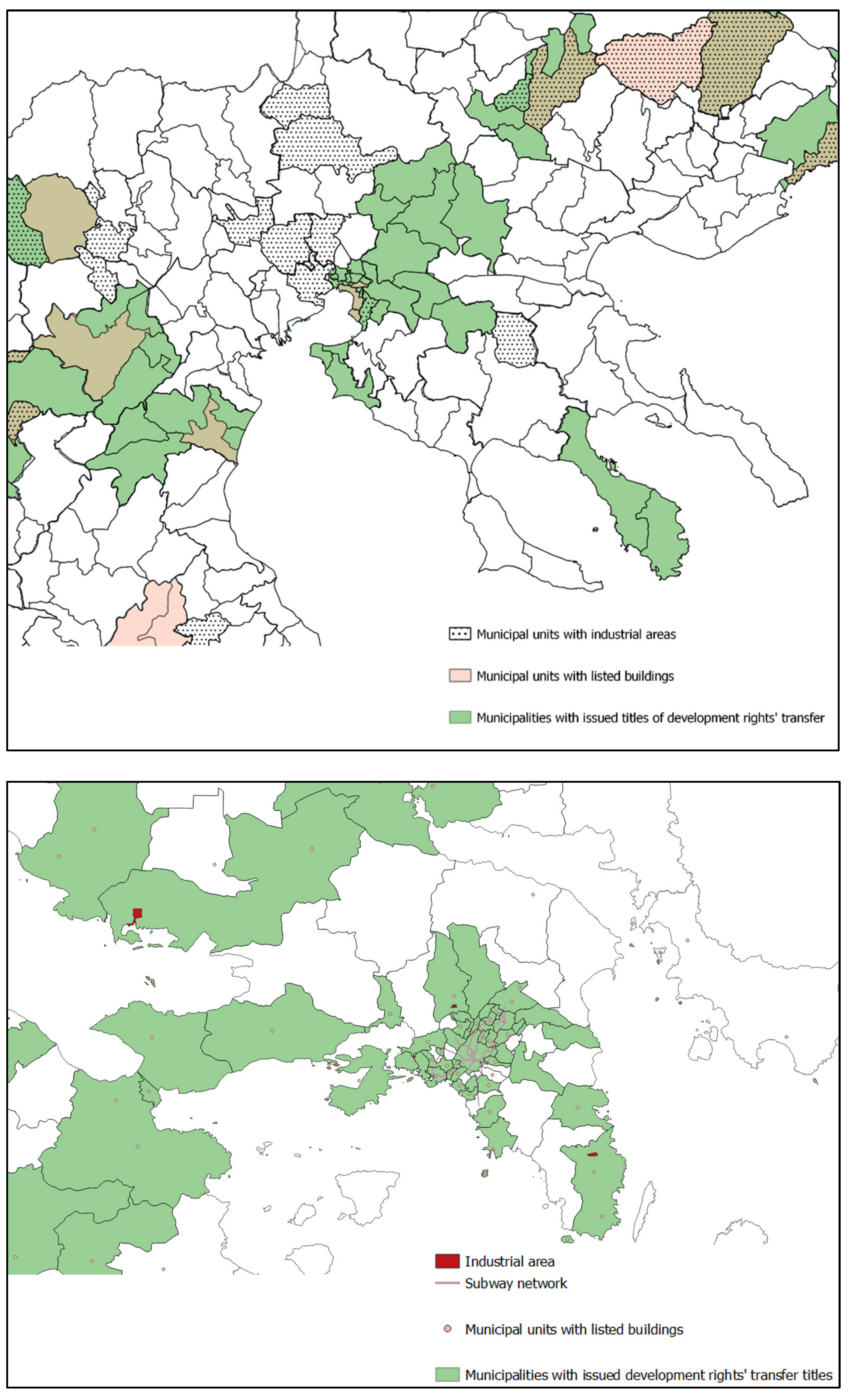
- Geographic and urban planning requirements. Geographic and urban planning requirements are associated with spatial relations between municipal units with a high number of “sending” and “receiving” parcels. They also relate to the existence of areas in need of increased development rights, avoiding population increases that would result in an excessive need for infrastructure and utilities (e.g., industrial areas). Moreover, limitations for the protection of areas of unique character and traditional architecture need to be considered within this objective.
- Funding limitations: According to a Ministerial Decision [43], RTZs may also be investigated within the preparation of Local Urban Plans (LUPs)5 and Special Urban Plans (SUPs)6. The development of LUPs/SUPs constitutes part of the National Urban Policy Reform that is currently ongoing in Greece, covering 227 municipalities throughout the country and funded by the RRF, as it applies to the development of RTZ study. Therefore, municipal units where LUPs and SUPs are conducted are excluded from the study for the development of RTZs. The difference between the two programs is that LUPs are related to the holistic reform of the national urban policy and the relevant planning system that horizontally affects a wide range of policy areas, including environmental protection and adaptation to climate change, built environment and development, protection of historic sites and buildings, allocation of public infrastructure, and allocation of investments [44], while the development of RTZ study focuses specifically on transferring building rights from encumbered land parcels and listed buildings. Moreover, the establishment of RTZs within LUPs may apply only in cases where “receiving“ parcels cover the needs set by the “sending” parcels. RTZ study emphasises municipalities where the “receiving” area cannot absorb the “sending” one; thus, the investigation for “receiving” parcels needs to be extended to neighbouring municipal units, neighbouring municipalities, municipalities within the same Regional Unit, or municipalities within the Region. Given the different aims of these two projects, municipal units where it can be justified that there are not enough “receiving” parcels to cover the offer of “sending” parcels may be included in the individual project for the development of RTZs.
3.3. Setting the Indicators Based on the Objectives
- Τhe quantity of encumbered parcels and non-materialised titles of development rights’ transfer in each municipal unit (Objective 1 described in Section 3.2) is unequivocally of a numerical nature; thus, the indicator to be used for its evaluation is the number of “sending” parcels in each municipal unit as well as the number of development rights’ transfer titles that have been issued based on previous legislation and have not materialised. The more “sending” parcels and non-materialised titles that exist in a municipal unit, the higher priority this municipal unit has to be selected for the development of RTZs. It is noted that existing titles of development rights’ transfer are titles that have been issued under revoked legislation regulating the transfer of development rights and cannot yet be “received” by another parcel.
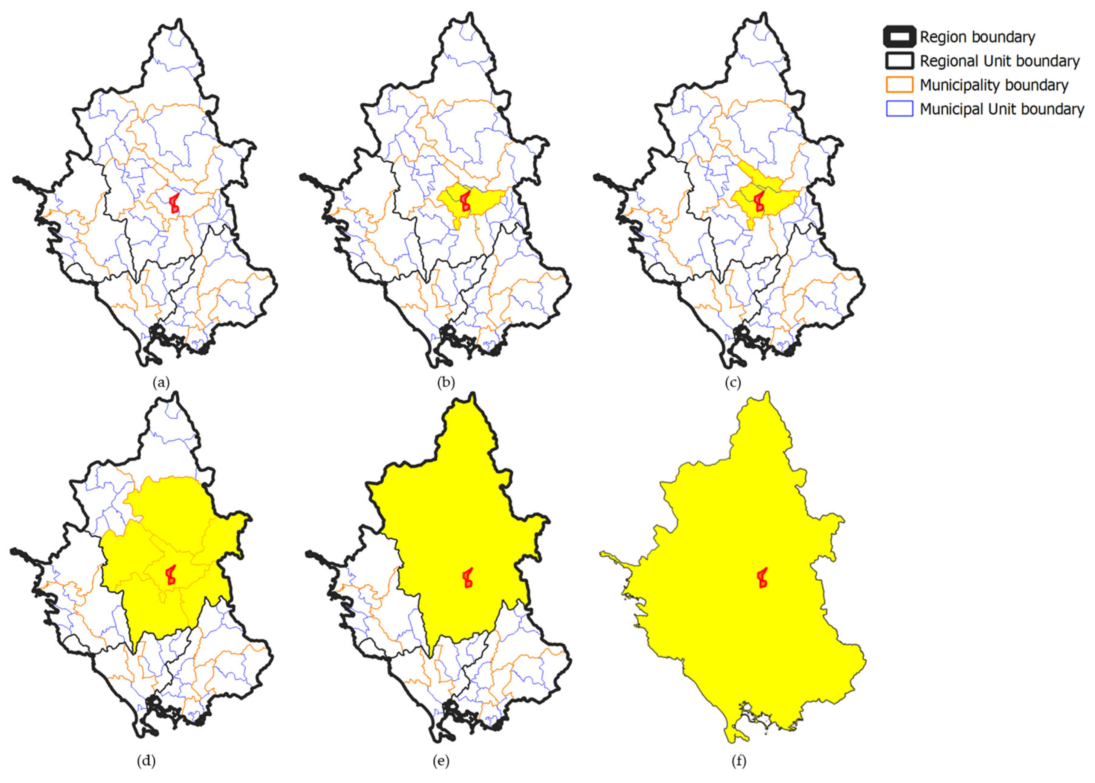
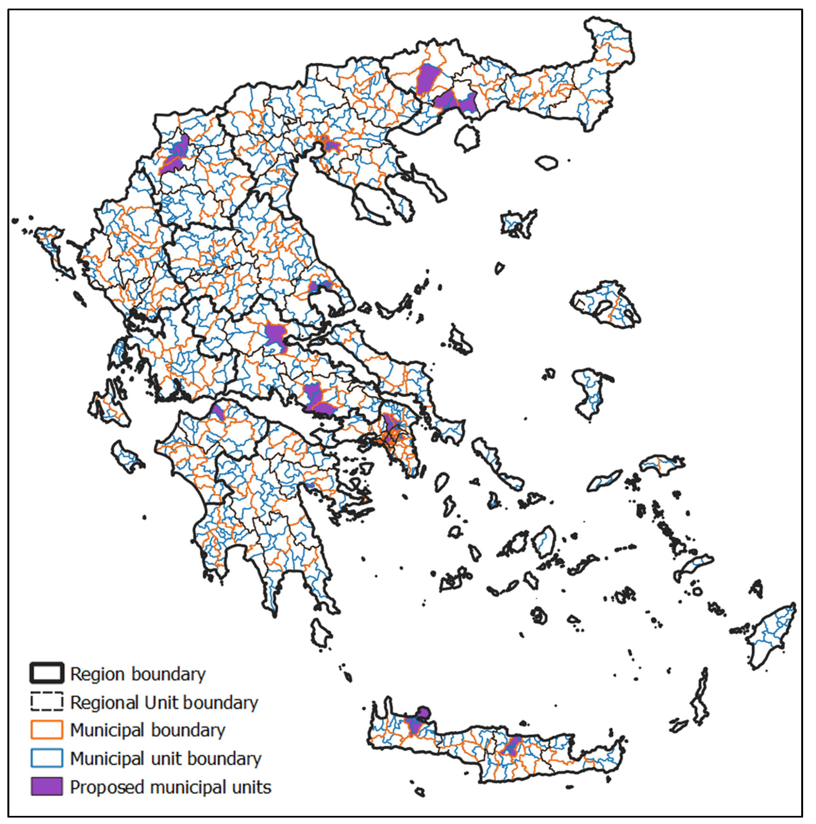
- Geographic limitations relate to the location of municipal units with large numbers of “sending” parcels and non-materialised titles and alternatives for the allocation of “receiving” parcels, extending gradually from neighbouring municipal units to municipalities within the same Region, as shown in Figure 2. Therefore, geographic relations constitute spatial indicators, based on the location of the municipal units identified in Objective 1. Urban planning requirements are combined in this research with geographic ones, as jurisprudence of the Hellenic Council of the State sets geographic limitations by excluding, inter alia, shores and islands from “receiving” areas due to urban planning purposes [45,46].
- Funding limitation indicators are also of a spatial connotation. Municipal units where LUPs are conducted, funded by the RRF, are excluded from the investigation. However, exceptions may apply for municipal units with an excessive number of “sending” parcels and issued titles of development rights’ transfer. In such cases, for the excepted municipal units, investigation for RTZs is not conducted within the LUP study, while investigation of the “receiving” parcels extends, gradually, from neighbouring municipal unit level to municipalities within the administrative Region.
3.4. Materials
4. Implementation of the Multi-Criteria Analysis
4.1. Objective 1
4.2. Objective 2
4.3. Objective 3
5. Results
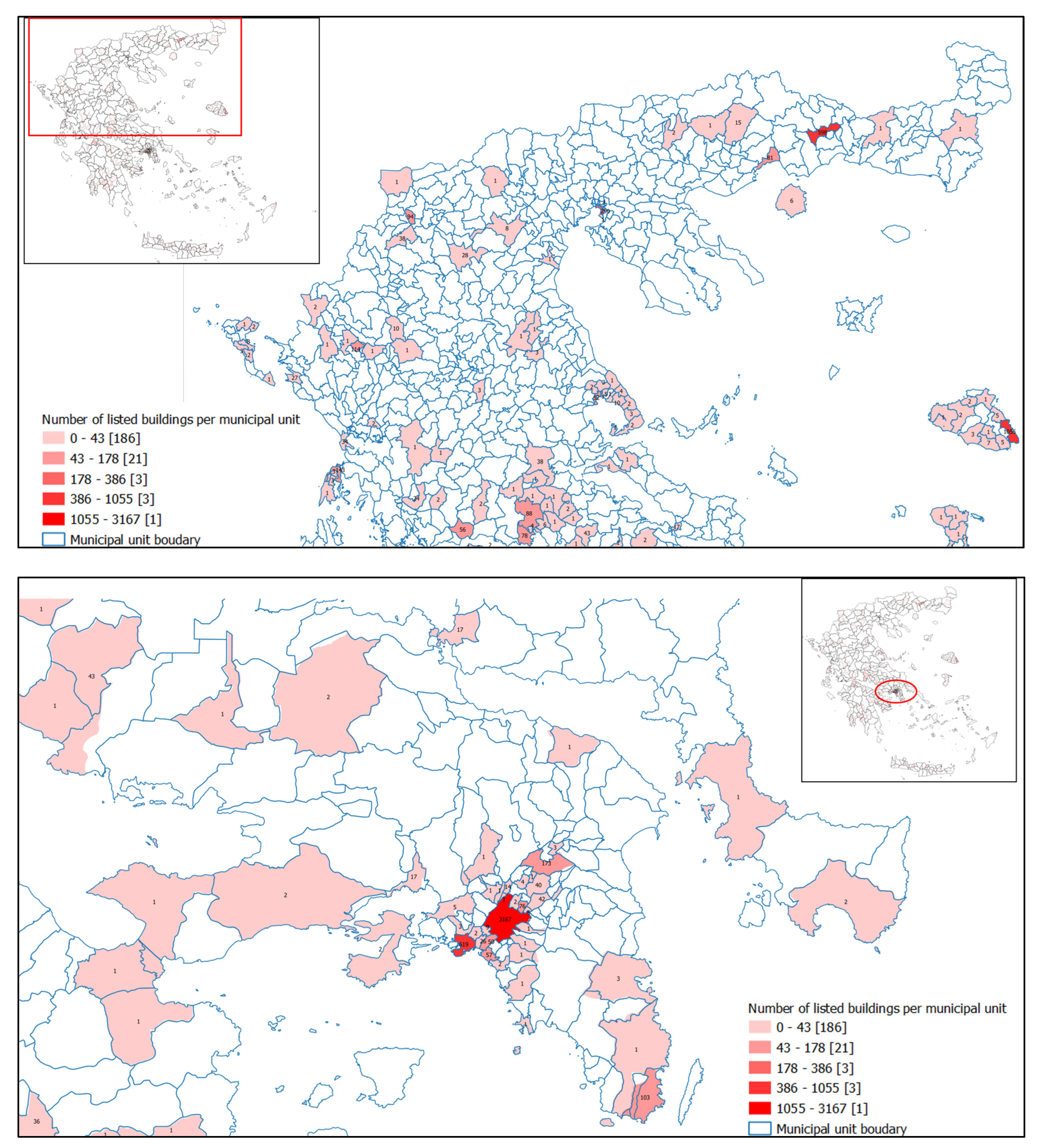
- Are those with the highest number of listed building and issued titles, regardless of their selection for LUP/SUP studies.
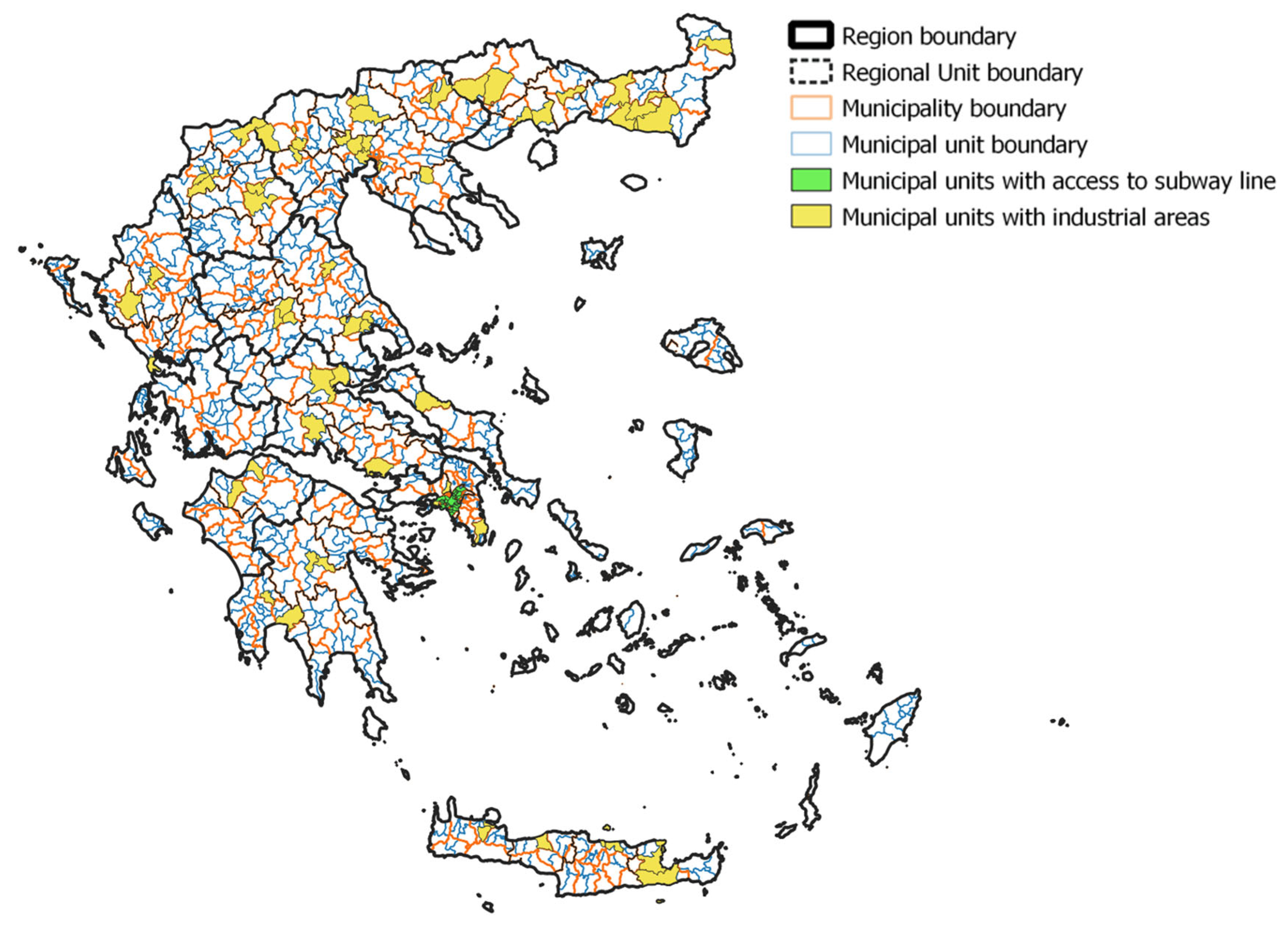
- Have established industrial areas, where increase of development rights will not result in population increase.
- Have access to the subway network.
- Are of low construction density, neighbouring municipal units with a high number of listed buildings or issued titles of development rights’ transfer. Such municipal units were selected even if their number of listed buildings or issued titles of development rights’ transfer was limited.
6. Discussion and Conclusions
- Data heterogeneity: The available data came from different administrative levels (municipal unit level and municipality level). Although municipalities constitute municipal units, and their spatial relations could be derived using GIS, this did not allow for analysis of all data on the municipal unit level.
- Investigation at municipal unit level: The selection of municipal units for this research was based on the administrative division of Greece and on the specific characteristics of this research. Investigation at the municipality level would lead to the selection of municipal units (within the municipality) not suitable for RTZ definition studies, increasing time and cost. On the other hand, investigation at the building block or land parcel level would actually mean conducting the RTZ definition studies for the whole country.
- Process automation: The specifications of this research (in terms of geographic characteristics and funding limitations) did not allow for fully automating the selection process. For example, excluded municipal units due to low number of “sending” parcels could be finally selected (as suitable “receiving” municipal units). Therefore, the selected and excluded municipal units were manually cross-checked.
Author Contributions
Funding
Data Availability Statement
Conflicts of Interest
| 1 | Public Law Restrictions (PLRs): Restrictions imposed by the State on individuals. |
| 2 | Transfer of Development Rights (TDR): TDR is a legal instrument that allows transferring development rights from a land parcel where restrictions are imposed (sending parcel) to another land parcel (receiving parcel). |
| 3 | Recovery and Resilience Facility (RRF): Temporary instrument of the European Union’s (EU) plan to fund EU states to implement reforms and investments towards sustainability, resilience, and green and digital transitions. |
| 4 | Right Transfer Zones (RTZs): The zones where development rights deriving from sending parcels can be transferred. |
| 5 | Local Urban Plans (LUPs): Municipal unit level plans defining (among others) land uses, building terms, residential areas, delimitation of settlements, definition of protected areas, and measures to adapt to climate change. |
| 6 | Special Unit Plan (SUP): Urban planning tool with the same content as LUP, of supra-local/strategic importance. |
References
- Levy, J. An Overview. In Contemporary Urban Planning, 11th ed.; Levy, J., Ed.; Routledge: New York, NY, USA, 2017; pp. 1–8. [Google Scholar]
- Givord, G. Cadastre 3D des Restrictions de Droit Public à la Propriété Foncière. Master’s Thesis, Conservatoire National des Arts et Métiers École Supérieure des Géomètres et Topographes, Paris, France, 2012. [Google Scholar]
- Kitsakis, D.; Dimopoulou, E. Possibilities of Integrating Public Law Restrictions to 3D Cadastres. In Proceedings of the 5th International FIG 3D Cadastre Workshop, Athens, Greece, 18–20 October 2016. [Google Scholar]
- Ferreira, A. Reconsidering the merit of market-oriented planning innovations: Critical insights on Transferable Development Rights from Coimbra, Portugal. Land Use Policy 2020, 99, 104977. [Google Scholar] [CrossRef]
- Bruno, E.; Falco, E.; Shabab, S.; Geneletti, D. Integrating ecosystem services in transfer of development rights: A literature review. Land Use Policy 2023, 131, 106694. [Google Scholar] [CrossRef]
- Lloyd, G. Transferable Density in Connection with Zoning. In Technical Bulletin; Urban Land Institute: Washington, DC, USA, 1961; p. 40. [Google Scholar]
- Panayotou, T. Conservation of Biodiversity and Economic Development: The Concept of Transferable Development Rights. Environ. Resour. Econ. 1994, 4, 91–110. [Google Scholar] [CrossRef]
- McConnell, V.; Kopits, E.; Walls, M. Using markets for land preservation: Results of a TDR program. J. Environ. Plan. Manag. 2006, 49, 631–651. [Google Scholar] [CrossRef][Green Version]
- Kaplowitz, M.; Machemer, P.; Pruetz, R. Planners’ experiences in managing growth using transferable development rights (TDR) in the United States. Land Use Policy 2008, 25, 387. [Google Scholar] [CrossRef]
- Galvão, I. Between the transfer of development rights and the equivalency values: The case study of Natal, Brazil. Int. J. Sustain. Dev. Plan. 2017, 12, 379–387. [Google Scholar] [CrossRef]
- Kumara, H.S.; Gopiprasad, S. Transfer of Development Rights (TDR) as an instruments for spatial planning implementation: Case of Bengaluru Metropolitan Area (BMA). In Proceedings of the 68th National Town and Country Planners Congress, Mumbai, India, 11–13 January 2020. [Google Scholar]
- Yokohari, M.; Murayama, A.; Terada, T. The Value of Grey. In Framing in Sustainability Science Theoretical and Practical Approaches; Mino, T., Kudo, S., Eds.; SpringerOpen: Singapore, 2020; pp. 57–96. [Google Scholar] [CrossRef]
- Menghini, G.; Gemperle, F.; Seidl, I.; Axhausen, K.W. Results of an Agent-Based Market Simulation for Transferable Development Rights (TDR) in Switzerland. Environ. Plan. B Plan. Des. 2015, 42, 157–183. [Google Scholar] [CrossRef]
- Falco, E.; Chiodelli, F. The transfer of development rights in the midst of the economic crisis: Potential, innovation and limits in Italy. Land Use Policy 2018, 72, 381–388. [Google Scholar] [CrossRef]
- Robb, A.; Stocker, L.; Payne, M.; Middle, G.J. Enabling Managed Retreat from Coastal Hazard Areas through Property Acquisition and Transferable Development Rights: Insights from Western Australia. Urban Policy Res. 2020, 38, 230–248. [Google Scholar] [CrossRef]
- Billaud, O.; Soubeyrand, M.; Sandra, L.; Lenormand, M. Comprehensive decision-strategy space exploration for efficient territorial planning strategies. Comput. Environ. Urban Syst. 2020, 83, 1. [Google Scholar] [CrossRef]
- Chakhar, S.; Mousseau, V. Multicriteria Decision Making, Spatial. In Book Title, 2nd ed.; Shekhar, S., Xiong, H., Eds.; Springer: Boston, MA, USA, 2008; pp. 747–753. [Google Scholar] [CrossRef]
- Monteiro, J.; Sousa, N.; Coutinho-Rodrigues, J.; Natividade-Jesus, E. Benchmarking real and ideal cities—A multicriteria analysis of city performance based on urban form. Cities 2024, 150, 105040. [Google Scholar] [CrossRef]
- Villegas, N.; Cruz Salvador, L.C.; dos Santos, A.C.P.; Madero, Y.S. A proposal to compare urban infrastructure using multi-criteria analysis. Land Use Policy 2021, 101, 105173. [Google Scholar] [CrossRef]
- Zambrano-Asanza, S.; Quirow-Tortos, J.; Franco, J. Optimal site selection for photovoltaic power plants using a GIS-based multi-criteria decision making and spatial overlay with electric load. Renew. Sustain. Energy Rev. 2021, 143, 110853. [Google Scholar] [CrossRef]
- Yildiz, S. Spatial multi-criteria decision making approach for wind farm site selection: A case study in Balıkesir, Turkey. Renew. Sustain. Energy Rev. 2024, 192, 114158. [Google Scholar] [CrossRef]
- Nuhu, S.; Manan, Z.; Alwi, S.; Reba, M. Roles of geospatial technology in eco-industrial park site selection: State–of–the-art review. J. Clean. Prod. 2021, 309, 127361. [Google Scholar] [CrossRef]
- Criado, M.; Martínez-Graña, A.; Santos-Francés, F.; Veleda, S.; Zazo, C. Multi-Criteria Analyses of Urban Planning for City Expansion: A Case Study of Zamora, Spain. Sustainability 2017, 9, 1850. [Google Scholar] [CrossRef]
- Law 880/1979; Government Gazette A. 58, 22.03.1979. Hellenic Republic: Athens, Greece, 1979. (In Greek)
- Hellenic Republic. The Constitution of Greece. Available online: https://www.hellenicparliament.gr/UserFiles/f3c70a23-7696-49db-9148-f24dce6a27c8/THE%20CONSTITUTION%20OF%20GREECE.pdf (accessed on 14 May 2025).
- Presidential Decree 470/1979; Government Gazette A. 138, 26.06.1979. Hellenic Republic: Athens, Greece, 1979. (In Greek)
- Presidential Decree 510/1979; Government Gazette A. 154, 10.07.1979. Hellenic Republic: Athens, Greece, 1979. (In Greek)
- Law 2300/1995; Government Gazette A. 69, 12.04.1995. Hellenic Republic: Athens, Greece, 1995. (In Greek)
- Hellenic Council of the State. Hellenic Council of the State Decision 4573; Hellenic Council of the State: Athens, Greece, 1996. (In Greek) [Google Scholar]
- Hellenic Council of the State. Hellenic Council of the State Decision 4574; Hellenic Council of the State: Athens, Greece, 1996. (In Greek) [Google Scholar]
- Hellenic Council of the State. Hellenic Council of the State Decision 6070; Hellenic Council of the State: Athens, Greece, 1996. (In Greek) [Google Scholar]
- Law 3044/2002; Government Gazette A. 197, 27.08.2002. Hellenic Republic: Athens, Greece, 2002. (In Greek)
- Hellenic Council of the State. Hellenic Council of the State Decision 2366; Hellenic Council of the State: Athens, Greece, 2007. (In Greek) [Google Scholar]
- Hellenic Council of the State. Hellenic Council of the State Decision 2367; Hellenic Council of the State: Athens, Greece, 2007. (In Greek) [Google Scholar]
- Hellenic Council of the State. Hellenic Council of the State Decision 3274; Hellenic Council of the State: Athens, Greece, 2008. (In Greek) [Google Scholar]
- Hellenic Council of the State. Hellenic Council of the State Decision 3921; Hellenic Council of the State: Athens, Greece, 2010. (In Greek) [Google Scholar]
- Law 4495/2017; Government Gazette A. 167, 03.11.2017. Hellenic Republic: Athens, Greece, 2017. (In Greek)
- Ministerial Decision 72508/1890; Government Gazette B. 3544, 03.08.2021. Hellenic Republic: Athens, Greece, 2021. (In Greek)
- Dean, M. A Practical Guide to Multi-Criteria Analysis; Technical Report; Bartlett School of Planning, University College London: London, UK, 2022. [Google Scholar]
- Department for Communities and Local Government. Multi-Criteria Analysis: A Manual; Department for Communities and Local Government: London, UK, 2009; Available online: https://eprints.lse.ac.uk/12761/1/Multi-criteria_Analysis.pdf (accessed on 3 February 2025).
- Gamper, C.; Turcanu, C. On the governmental use of multi-criteria analysis. Ecol. Econ. 2007, 62, 298–307. [Google Scholar] [CrossRef]
- Government Analysis Function. An Introductory Guide to Multi-Criteria Decision Analysis (MCDA). Available online: https://analysisfunction.civilservice.gov.uk/policy-store/an-introductory-guide-to-mcda/ (accessed on 3 February 2025).
- Ministerial Decision 72343/1885; Government Gazette B. 3545, 03.08.2021. Hellenic Republic: Athens, Greece, 2021. (In Greek)
- Vassi, A.; Siountri, K.; Papadaki, K.; Iliadi, A.; Ypsilanti, A.; Bakogiannis, E. Policy Reform through the Local Urban Plans (LUPs) and the Special Urban Plans (SUPs), Funded by Recovery and Resilience Facility (RRF). Land 2022, 11, 1231. [Google Scholar] [CrossRef]
- Chrysanthakis, C. Commentary on the Hellenic Council of State Decision 2366/2007 on Transfer of Development Rights. Available online: https://nomosphysis.org.gr/11092/nomologia-2007ii/ (accessed on 1 February 2025). (In Greek).
- Varotsos, A. Transfer of Development Rights. In Proceedings of the PRODEXRO 2007 Conference, Athens, Greece, 23–24 October 2007. [Google Scholar]
- Hellenic Statistical Authority. Digital Cartographical Data (DCD). Available online: https://www.statistics.gr/digital-cartographical-data (accessed on 15 January 2025). (In Greek).
- Law 3852/2010; Government Gazette A. 87, 07.06.2010. Hellenic Republic: Athens, Greece, 2010. (In Greek)
- Law 4555/2018; Government Gazette A. 133, 19.07.2018. Hellenic Republic: Athens, Greece, 2018. (In Greek)
- ESTIA. Ministry of Environment and Energy. Available online: https://estia.minenv.gr/ (accessed on 2 February 2025).
- Archaeological Cadastre. Directorate of the National Archive of Monuments. Available online: https://www.arxaiologikoktimatologio.gov.gr/en/content/about-archaeological-cadastre (accessed on 15 March 2025).
- Public Sector Open Data Registry. GIS Athens Metro Operating. Available online: http://beta.data.gov.gr/ (accessed on 12 February 2025).





| Objective | Outcome | Indicators |
|---|---|---|
| “Sending” parcels | Desired municipal units | Number of “sending” parcels Number of issued titles |
| Geographic and urban planning limitations | Exclusion | Municipal units on islands |
| Desired municipal units | Existence of “receiving” parcels Proximity to “sending” parcels | |
| Funding | Exclusion | Municipal units not falling under RRF LUP * |
| Data | Format | Source |
|---|---|---|
| Law 4495/2017 | Descriptive data | Government gazette |
| MD 72508/1890 | Descriptive data | Government gazette |
| Municipal unit boundaries | Vector data | Hellenic Statistical Authority |
| Municipal boundaries | Vector data | Hellenic Statistical Authority |
| Regional Unit boundaries | Vector data | Hellenic Statistical Authority |
| Region boundaries | Vector data | Hellenic Statistical Authority |
| Number of listed buildings | Spreadsheet table | Ministry of Environment and Energy |
| Number of issued titles of development rights’ transfer | Spreadsheet table | Ministry of Environment and Energy |
| Municipal units where LUPs/SUPs were conducted | Vector data | Ministry of Environment and Energy |
| Industrial areas | Vector data | Ministry of Development |
| Subway network | Vector data | Public Sector Open Data Registry |
| Selected Municipal Units | Total | Coverage (Total) | Coverage (Continental) | |
|---|---|---|---|---|
| Number of listed buildings | 5896 | 9397 1 | 62.74% | 74.18% |
| Number of issued titles | 2965 | 3821 2 | 77.60% | 79.94% |
| Area of issued titles (m2) | 316,696.93 | 434,917.63 3 | 72.82% | 73.98% |
Disclaimer/Publisher’s Note: The statements, opinions and data contained in all publications are solely those of the individual author(s) and contributor(s) and not of MDPI and/or the editor(s). MDPI and/or the editor(s) disclaim responsibility for any injury to people or property resulting from any ideas, methods, instructions or products referred to in the content. |
© 2025 by the authors. Licensee MDPI, Basel, Switzerland. This article is an open access article distributed under the terms and conditions of the Creative Commons Attribution (CC BY) license (https://creativecommons.org/licenses/by/4.0/).
Share and Cite
Kitsakis, D.; Vassi, A.; Iliadi, A.; Bakogiannis, E. Using Multi-Criteria Analysis for Urban Planning: Selection of Municipal Units in Which to Conduct Studies of Development Rights’ Transfer Zones (RTZs) in Greece. Land 2025, 14, 1091. https://doi.org/10.3390/land14051091
Kitsakis D, Vassi A, Iliadi A, Bakogiannis E. Using Multi-Criteria Analysis for Urban Planning: Selection of Municipal Units in Which to Conduct Studies of Development Rights’ Transfer Zones (RTZs) in Greece. Land. 2025; 14(5):1091. https://doi.org/10.3390/land14051091
Chicago/Turabian StyleKitsakis, Dimitrios, Avgi Vassi, Alkistis Iliadi, and Efthimios Bakogiannis. 2025. "Using Multi-Criteria Analysis for Urban Planning: Selection of Municipal Units in Which to Conduct Studies of Development Rights’ Transfer Zones (RTZs) in Greece" Land 14, no. 5: 1091. https://doi.org/10.3390/land14051091
APA StyleKitsakis, D., Vassi, A., Iliadi, A., & Bakogiannis, E. (2025). Using Multi-Criteria Analysis for Urban Planning: Selection of Municipal Units in Which to Conduct Studies of Development Rights’ Transfer Zones (RTZs) in Greece. Land, 14(5), 1091. https://doi.org/10.3390/land14051091


