


Research on the Construction and Practice of an Urban–Rural Integration Planning Model from the Perspective of Element Flow: A Case Study of Xiuzhou District, Jiaxing City

Abstract
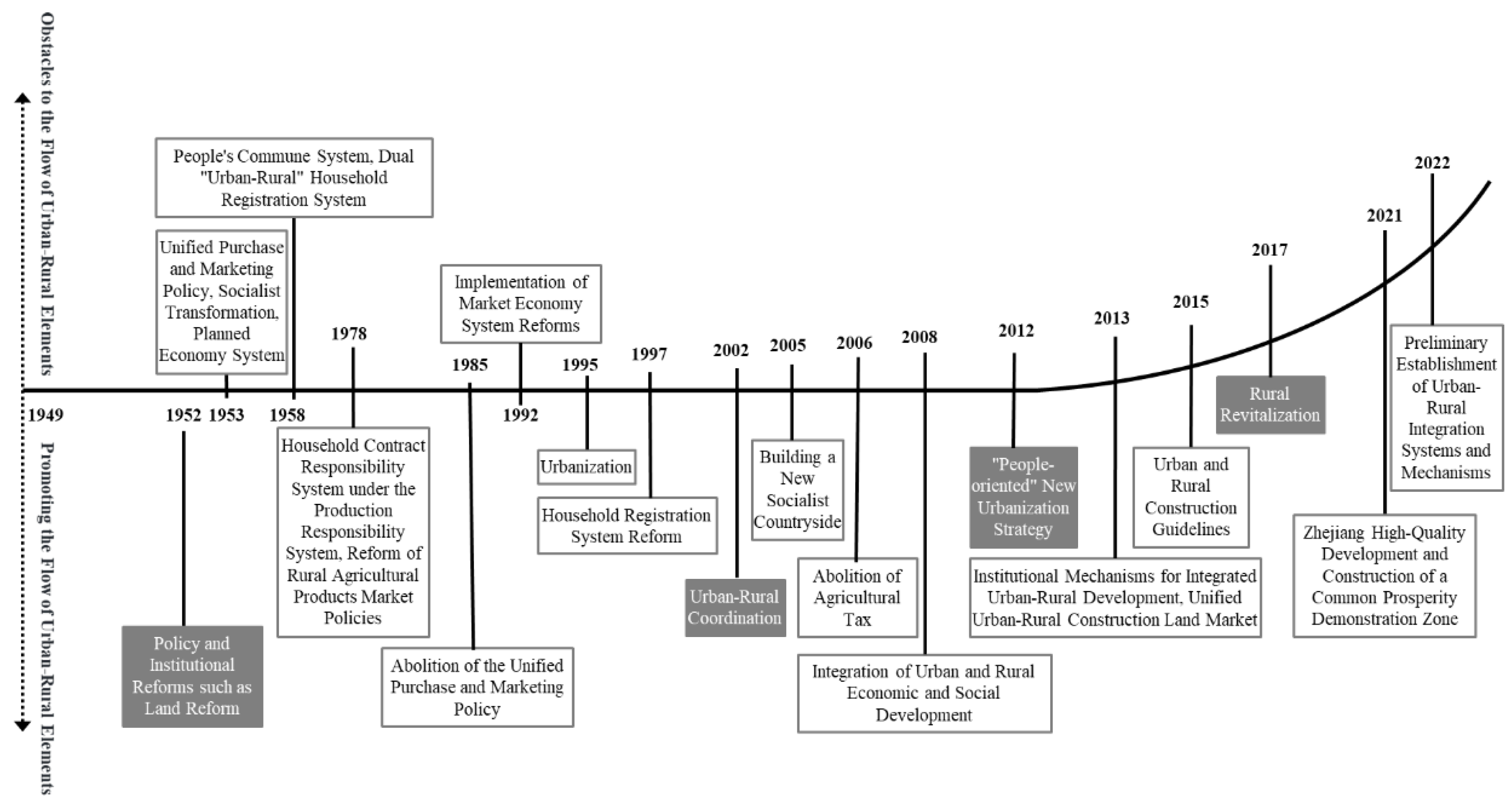
1. Introduction
2. Literature Review
3. Constructing Urban–Rural Integration Models
3.1. Cities Possess a Strong Resource Base
3.2. Towns as the Link Between Cities and Villages
3.3. Rural Areas as the Support and Guarantee for Urban–Rural Development
3.4. Constructing Urban–Rural Integration Models and Design Strategies
- Develop an integrated urban–rural spatial planning design and propose a new pattern for production, life, and ecology;
- Build an integrated urban–rural security system design and establish new paths for common prosperity, shared benefits, and collaborative governance;
- Intensify the integration of urban–rural industrial development design, forming an efficient and high-quality development system;
- Promote the integration of urban–rural resource circulation design and establish an innovative and interactive development system;
- Advances in the integration of urban–rural infrastructure design, improving convenient and low-carbon travel experiences;
- The integration of urban–rural public service design should be promoted to create an equitable and inclusive service system.
4. Urban–Rural Integration Planning in Xiuzhou District
4.1. Current Characteristics of Resource Endowment and Development
4.2. Constructing Factor Integration Design and Defining Integration Measures
4.2.1. Spatial Planning Dimension: Building a Fundamental Platform for Urban–Rural Integration from the Perspectives of Land, Transportation, and Public Services
4.2.2. Policy Formulation Dimension: Building a Movement of Factors Guarantee from the Perspectives of Ecology, Population, and Industry
4.3. Promoting Stratified Strategy Transmission and Constructing Work Pathways
5. Practice Effect and Feedback of Urban Rural Integration in Xiuzhou District
6. Discussion and Conclusions
Author Contributions
Funding
Informed Consent Statement
Data Availability Statement
Acknowledgments
Conflicts of Interest
References
- Xie, S.; Zhou, F.; Wu, T.; Fu, C. Evaluation and spatial pattern evolution of urban and rural integrated development in the Yangtze River Delta. Urban Dev. Stud. 2020, 27, 28–32. [Google Scholar]
- Wang, Y.; Yang, J. Centennial Rural Governance by the Communist Party of China: From Native Rural China to Urban-rural China—Based on the perspective of urban-rural relationship. J. Hebei Univ. Econ. Bus. 2021, 42, 11–18. [Google Scholar]
- Zhou, Y.; Wei, B.; Xie, L. Suggestions on the Optimization of Spatial Coordinated Planning Under the Historical Evolution of Urban-Rural Relationship in China. J. Hum. Settl. West China 2019, 34, 25–31. [Google Scholar]
- Chen, M.; Zhou, Y.; Huang, X.; Ye, C. The Integration of New-Type Urbanization and Rural Revitalization Strategies in China: Origin, Reality and Future Trends. Land 2021, 10, 207. [Google Scholar] [CrossRef]
- Wang, J.; Li, S. Political and Economic Analysis of Urban-rural Relationships and Integration under Cyclical Spatiotemporal Logic. Urban Dev. Res. 2024, 31, 32–38. [Google Scholar]
- He, R.W. Urban-rural integration and rural revitalization: Theory, mechanism and implementation. Geogr. Res. 2018, 37, 2127–2140. [Google Scholar]
- Ge, D.; Long, H. Rural spatial governance and urban-rural integration development. Acta Geogr. Sin. 2020, 75, 1272–1286. [Google Scholar]
- Long, H.; Tu, S.; Ge, D.; Li, T.; Liu, Y. The allocation and management of critical resources in rural China under restructuring: Problems and prospects. J. Rural Stud. 2016, 47, 392–412. [Google Scholar] [CrossRef]
- He, H. The core content and path analysis of urban and rural integrated development. Agric. Econ. 2018, 2, 91–92. [Google Scholar]
- Chen, Y.; Duan, W.; Chi, Y.; Li, P.; Liu, H. Study on County Village Type Identification Under the Background of Urban—Rural Integration Development: A Case Study of Zhaoyuan City in Shandong Province. Urban Dev. Stud. 2022, 29, 28–37. [Google Scholar]
- Liu, Y. Research on the urban-rural integration and rural revitalization in the new era in China. Acta Geogr. Sin. 2018, 73, 637–650. [Google Scholar]
- Hibbard, M.; Frank, K.I. Bringing rurality back to planning culture. J. Plan. Educ. Res. 2024, 44, 1212–1222. [Google Scholar] [CrossRef]
- Gren, Å.; Andersson, E. Being efficient and green by rethinking the urban-rural divide—Combining urban expansion and food production by integrating an ecosystem service perspective into urban planning. Sustain. Cities Soc. 2018, 40, 75–82. [Google Scholar] [CrossRef]
- Liu, Y. Research on the Development Strategy of Suburban Fusion Village Space under the Background of Rural Revitalization Strategy—Taking Qiuxian Village in Beijing as an example. Beijing Univ. Civ. Eng. Archit. 2021. [Google Scholar] [CrossRef]
- Zhang, C.; Guo, P.; Bao, Q. Research on Planning of Suburban Rural Complex from the Perspective of Urban Rural Integration: A Case Study of Nanjing Jiangning Xitian Rural Complex. Dev. Small Cities Towns 2021, 39, 95–105 +115. [Google Scholar]
- Gu, Y.; Xu, Y. Research on the Evaluation Index System of Urban Rural Integration. Zhejiang Soc. Sci. 2004, 6, 93–97+6. [Google Scholar]
- Ji, S.; Duan, J.; Xue, S.; Li, L.; Gong, Z. Urban design methods based on space gene inheritance: A case study of water-town public center in the demonstration zone for integrated development in the Yangtze river delta region. City Plan. Rev. 2023, 47, 4–12+48. [Google Scholar]
- Chen, X.; Hu, J. Rural Spatial Governance in Jiangsu Province: Stages, Trajectories, and Models. Urban Plan. Forum 2024, 1, 38–45. [Google Scholar]
- Chen, L.; Duan, D.; Cui, L. Rural in-situ urbanization path and planning response in metropolitan fringe: Practice and exploration of Xi’an. City Plan. Rev. 2023, 47, 82–91. [Google Scholar]
- Jiang, J. Research on the Strategies of Suburban Villages’ Organic Renewal in Megacities under the Pattern of Urban-Rural Integration: A Case Study of Villages in Suburb and Outer Suburb of Shanghai. Shanghai Urban Plan. Rev. 2023, 4, 62–69. [Google Scholar]
- Huang, H.; Song, D.; Wang, L.; Yang, G.; Wang, Y.; Fei, L.; Lynam, A. Enhancing Urban Rural Integration in China: A Comparative Case Study of Introducing Small Rural Industries in Huangyan-Taizhou. Land 2024, 13, 946. [Google Scholar] [CrossRef]
- He, Y.; Wen, C.; Fang, X.; Sun, X. Impacts of urban-rural integration on landscape patterns and their implications for landscape sustainability: The case of Changsha, China. Landsc. Ecol. 2024, 39, 129. [Google Scholar] [CrossRef]
- Wang, R.; Tan, R. Rural Renewal of China in the Context of Rural-Urban Integration: Governance Fit and Performance Differences. Sustainability 2018, 10, 393. [Google Scholar] [CrossRef]
- Fu, X. Transformation Mode and Path Construction of Industrial Zones Surrounding Metropolises: A Case Study based on Xi’an Fengdong International Automobile City. South Archit. 2023, 3, 22–28. [Google Scholar]
- Zeng, P.; Ren, X.; Man, D. Research on Rural Multi-Level Development Paths in Metropolitan Areas from the Perspective of Urban-Rural Integration: A Case Study of Zaolinzhuang Village in Tongzhou District of Beijing. Mod. Urban Res. 2023, 3, 60–67. [Google Scholar]
- Bao, X.; Liu, S.; Chen, S. Spatial differentiation and influencing factors of rural territorial multi-functions in urban-rural integration area: A case study of Eastern Fuzhou. J. Nat. Resour. 2022, 37, 2688–2702. [Google Scholar] [CrossRef]
- Pan, Z.; Ma, L.; Tian, P.; Zhu, Y. Spatiotemporal evolution, regional differences and convergence of urban-rural integrated development in Northeast China. J. Nat. Resour. 2023, 38, 3093–3115. [Google Scholar] [CrossRef]
- Xu, S.; Gao, H. Navigating Research Frontiers in China’s Rural Planning: A Bibliometric Analysis of Sustainable Development. Sustainability 2025, 17, 340. [Google Scholar] [CrossRef]
- Chen, K.; Zhou, J.; Chen, Y.; Chen, J. Pattern and Mechanism of The Flow of Urban-rural Land Elements in China. Econ. Geogr. 2024, 44, 183–192. [Google Scholar]
- Jin, H.; Du, C.; Wang, M.; Wang, Y.; Chen, L. Reducing the Consumption Gap Between Urban and Rural Areas: The Role of Rural Industrial Integration in China. Sustainability 2024, 16, 10646. [Google Scholar] [CrossRef]
- Wu, Z. A Rational Urban Planning Method Based on Flow Shaping. Available online: https://www.planning.org.cn/report/view?id=54 (accessed on 3 August 2024).
- Li, M.; Wen, W.; Ma, W.; Jin, Y. Research on the Common Prosperity Effect of Integrated Regional Expansion: An Empirical Study Based on the Yangtze River Delta. Land 2025, 14, 426. [Google Scholar] [CrossRef]
- Liu, J.; Li, Y.; Bai, H.; Shang, K.; Deng, Y.; Mao, J. Transformative Aspects of Agricultural Modernization and Its Land Use Requirements: Insights from Chinese Case Studies. Land 2025, 14, 352. [Google Scholar] [CrossRef]
- Zhang, A. Analysis of the Sustainable Development Pathway of Urban–Rural Integration from the Perspective of Spatial Planning: A Case Study of the Urban–Rural Fringe of Beijing. Sustainability 2025, 17, 1857. [Google Scholar] [CrossRef]
- Yang, J.; Ge, D.; Sun, P.; Yuan, Z. The mechanism of urban-rural integrated development based on the “population-land-capital” factor flow: A case study of Jiangxi Province. Resour. Sci. 2025, 47, 110–124. [Google Scholar]
- Zuo, Y.; Yang, C.; Xin, G.; Wu, Y.; Chen, R. Driving Mechanism of Comprehensive Land Consolidation on Urban Rural Development Elements Integration. Land 2023, 12, 2037. [Google Scholar] [CrossRef]
- National Platform for Common Geospatial Information Services. Available online: https://map.tianditu.gov.cn/ (accessed on 6 March 2023).
- Xiuzhou Ecological Conservation 14th Five-Year Plan. Available online: https://www.xiuzhou.gov.cn/art/2022/9/13/art_1229410676_4993607.html (accessed on 6 March 2023).
- 2022 Xiuzhou Statistical Yearbook. Available online: https://www.xiuzhou.gov.cn/art/2022/11/11/art_1229470969_2446872.html (accessed on 6 March 2023).
- Historical Editions of Statistical Yearbooks. Available online: https://search.zj.gov.cn/jrobotfront/search.do?websiteid=330411000000000&tpl=763&q=%E7%BB%9F%E8%AE%A1%E5%B9%B4%E9%89%B4&p=1&pg=&pos=&searchid=96&oq=&eq=&begin=&end= (accessed on 6 March 2023).
- Work Situation of District Human Resources and Social Security Bureau in 2022 and Work Ideas in 2023. Available online: https://www.xiuzhou.gov.cn/art/2023/5/17/art_1229412122_5113570.html (accessed on 12 June 2023).
- Historical Annual Work Summary of Xiuzhou District Human Resources and Social Security Bureau. Available online: https://www.xiuzhou.gov.cn/col/col1229412122/index.html (accessed on 6 March 2023).
- 2022 Government Work Report. Available online: https://www.xiuzhou.gov.cn/art/2023/3/9/art_1229406653_5077578.html (accessed on 12 June 2023).
- Historical Statistical Bulletins and Analyses. Available online: https://www.xiuzhou.gov.cn/col/col1228921763/index.html (accessed on 6 March 2023).
- Other Statutorily Proactive Disclosure Content. Available online: https://www.xiuzhou.gov.cn/col/col1229104166/index.html?number=GG0107 (accessed on 6 March 2023).
- Comprehensive Economic Tables. Available online: http://data.tjj.zj.gov.cn/page/systemmanager/admin/homePage.jsp?orgCode=330411 (accessed on 6 March 2023).
- Notice of the People’s Government of Xiuzhou District of Jiaxing City on Printing and Distributing the Measures for Compensation and Resettlement of Collective Land and Housing Demolition in Xiuzhou District of Jiaxing City. Available online: https://www.xiuzhou.gov.cn/art/2025/3/24/art_1229405725_2547864.html (accessed on 26 March 2025).
- Notice of the People’s Government Office of Xiuzhou District of Jiaxing City on Printing and Distributing the Measures for the Implementation of the Registration and Filing of the Settlement of Local Agricultural Transferred Population in Xiuzhou District. Available online: https://www.xiuzhou.gov.cn/art/2024/10/11/art_1229405725_2530789.html (accessed on 18 November 2024).
- Notice of Jiaxing Xiuzhou District People’s Government Office on Printing and Distributing the Administrative Measures for the Withdrawal of Paid Transfer of Rural Land Contractual Management Right in Xiuzhou District (for Trial Implementation). Available online: https://www.xiuzhou.gov.cn/art/2022/2/23/art_1229405725_2394298.html (accessed on 12 June 2023).
- Xiuzhou Integrated Transport 14th Five-Year Plan. Available online: https://www.xiuzhou.gov.cn/art/2023/10/7/art_1229411520_5183341.html (accessed on 10 October 2023).
- Transport Bureau Disclosures. Available online: https://www.xiuzhou.gov.cn/col/col1229405627/index.html (accessed on 2 December 2024).
- Social Security 14th Five-Year Plan. Available online: https://www.xiuzhou.gov.cn/col/col1229633237/index.html (accessed on 12 June 2023).
- Tang, J.; Li, F.; Wu, G. Research on the difficulties and countermeasures of systematic integration of urban and rural areas under the background of rural revitalization strategy—A case study of Xiuzhou District, Jiaxing City. Shanxi Agric. Econ. 2022, 4, 106–108. [Google Scholar]
- Digital Empowerment Makes Water Control More Accurate. Available online: https://www.xiuzhou.gov.cn/art/2022/12/5/art_1684823_59208287.html (accessed on 2 December 2024).
- Statistical Bulletin on National Economic and Social Development of Xiuzhou District in 2024. Available online: https://www.xiuzhou.gov.cn/art/2025/2/20/art_1228921763_59231597.html (accessed on 21 February 2025).
- Analysis on the Economic Operation of Xiuzhou District in 2024. Available online: https://www.xiuzhou.gov.cn/art/2025/2/10/art_1228921764_59231338.html (accessed on 21 February 2025).
- “Three Platforms” Lead Xiuzhou to a New Height. Available online: https://www.xiuzhou.gov.cn/art/2025/2/10/art_1684823_59231350.html (accessed on 21 February 2025).
- 167 Items! Jiaxing Adds “Hard Support” to the Development of Modern Agriculture. Available online: https://www.xiuzhou.gov.cn/art/2025/1/14/art_1684827_59230822.html (accessed on 21 February 2025).
- Xiuzhou District Was Selected into the Provincial Pilot List of Reform and Exploration for Common Prosperity. Available online: https://www.xiuzhou.gov.cn/art/2022/6/20/art_1684823_59202845.html (accessed on 2 December 2024).
- Youchegang Town, an Example of Human Settlements in China! Available online: https://www.xiuzhou.gov.cn/art/2024/3/8/art_1229631645_5274360.html (accessed on 2 December 2024).
- Xiuzhou Practice Won the Provincial Excellent Case Award. Available online: https://www.xiuzhou.gov.cn/art/2024/11/11/art_1229443730_59228963.html (accessed on 2 December 2024).
- “Turning Earth into Gold”! Xiuzhou’s “Multi Field Integration” Rate is 93.97%, Ranking in the Forefront of the City. Available online: https://mp.weixin.qq.com/s/9xiFofU_N3ug6KqSI32U0g (accessed on 10 March 2025).
- Xiuzhou District National Modern Agricultural Industrial Park Passed the “National Examination”. Available online: https://www.xiuzhou.gov.cn/art/2025/4/18/art_1684825_59232912.html (accessed on 21 April 2025).


| Data Category | Data Content | Data Source |
|---|---|---|
| Ecological | Data from the Third National Land Survey of China; ecological resource statistics; geographical layout data; wetland park planning data; regional topography, geomorphology, and climatic characteristic data; ecological resource value assessment data; river and lake water quality reports; watershed functional zoning data; key lake area planning data; biodiversity statistics. | Conference and Interviews: Collected via coordination meetings with the Development and Reform Bureau, Bureau of Natural Resources and Planning, and Environmental Protection Bureau; compilation of geographic information data; review of superior-level plans and special reports such as the Yangtze River Delta Ecological Green Integrated Development Demonstration Zone Plan, Wetland Ecological Restoration Plan, and Ecological Environment Protection and Green Development Plan. |
| Website Downloads: Field investigations and sample analyses [37,38] | ||
| Population | Statistics on urban and rural population distribution; data on residents’ income levels and sources; urban and rural social security data. | Conference and Interviews: Sourced from the Development and Reform Commission and Bureau of Statistics (census data), supplemented by field surveys, structured questionnaires on population structure and social security, and community interviews. |
| Website Downloads: Five-year statistical yearbooks from governments [39,40], and annual work reports from the Social Security Bureau [41,42]. | ||
| Industry | Data on industrial output, production value, sales, tax revenue, profit, and industrial scale; key indicators of the socio-economic, agricultural and rural, and industrial economies; economic indicators of enterprises above designated size by sector; self-operated import/export data; major economic indicators of large-scale enterprises; lists and economic data of agriculture–culture–tourism industry chain enterprises; data from the district’s 14th Five-Year industrial development plan. | Conference and Interviews: Obtained through coordination meetings with the Development and Reform Commission and Bureau of Economy and Commerce (industrial development reports); analysis of industrial association reports; field visits to large-scale enterprises; review of special reports such as the district’s cultural tourism development plan and the high-tech zone industrial park plan. |
| Website Downloads: Agricultural production statistics from the Bureau of Agriculture and Rural Affairs [43,44,45]; Comprehensive Economic Data [46]. | ||
| Land | Data from the Third National Land Survey of China; current land use status and planning data; special data on comprehensive land consolidation; information on land quota allocation and land transfer. | Conference and Interviews: Acquired through coordination meetings with the Development and Reform Commission, Bureau of Natural Resources and Planning, and Bureau of Agriculture and Water Resources (land use and planning data, collective land transaction platform data); field surveys and mapping investigations; analysis of superior-level plans and special reports such as village demolition and resettlement policy documents, comprehensive land consolidation plans, village consolidation schemes, and the rural revitalization strategic plan. |
| Website Downloads: Village demolition and resettlement policy documents [45,47,48,49]. | ||
| Transportation | Data from the district’s 14th Five-Year integrated transportation plan; urban and rural transportation network layout data; distribution and service radius data of public transportation facilities. | Conference and Interview: Collected via coordination meetings with the Transportation Bureau (current status and planning data of the regional integrated transportation system); review of superior-level plans and special reports such as the district’s 14th Five-Year integrated transportation plan and three-dimensional transportation planning. |
| Website Downloads: District’s 14th Five-Year integrated transportation plan and three-dimensional transportation planning [50,51]. | ||
| Public Service | Data on the configuration and distribution of various public service facilities; coverage of public service resources; quality evaluation data of urban and rural public service facilities. | Conference and Interviews: Field surveys of community public facilities; analysis of special reports such as government public service evaluation reports. |
| Website Downloads: Education Bureau, Health Commission, and Social Security Bureau (statistical data) [44,52]. |
| City | Towns | Rural Areas | Main Current Characteristics | Integration Development Directions | |
|---|---|---|---|---|---|
| Ecological | Homogeneous: Urban ecological landscape resources are singular, primarily consisting of lakes and urban greenery. | Chaotic: The ecological appearance of towns is mixed, with a distinct urban–rural interface. | Rich: Rural ecological resources combine urban-type landscape features, forming a relatively rich ecosystem. | The layout of ecosystems is dispersed, with weak urban–rural integration of ecosystems and insufficient coordination. | The ecological factors and environment of rural areas can be integrated into the overall development of cities and towns, enhancing the environmental quality of urban and town areas. |
| Rural ecological resources have good basic conditions but have not been fully or effectively utilized. | |||||
| In some areas, the water quality of rivers and lakes is poor, with insufficient self-purification capacity. | |||||
| In some areas, the terrain is low-lying, leading to ecological safety issues. | |||||
| Biodiversity needs to be restored. | |||||
| Population | Dense: Primarily concentrated in Xiuhu New City, with multiple income channels for urban residents. | Moderate: The population mobility in towns is high, with residents’ income mainly derived from retail, subsidies, and agricultural land transfer rents. | Rural Areas: Sparse: The population mainly consists of stay-behind groups, with relatively singular income sources, mainly from farming or agricultural land transfer rents. | The income gap between urban and rural residents is small, but the overall income level is relatively low. | Cities should increase employment opportunities and income channels for rural populations, diversify the economic sources of rural residents, while standardizing social welfare standards for both urban and rural populations, and enhancing the social awareness and ideology of rural residents. |
| Unified as urban residents, but there are still significant differences in social security and other aspects. | |||||
| Villagers have relatively poor cultural and ideological awareness. | |||||
| Rural population loss is severe, with most of the stay-behind population consisting of the elderly and low-end industrial workers. | |||||
| Industrial | Rich: Focused on traditional industries such as garment manufacturing and product processing, with the establishment of three major industrial platforms. | Normal: Includes small-scale, workshop-style garment production and food manufacturing. | Distinctive: Strong agricultural production foundation, with abundant sightseeing, tourism, and cultural activities in rural areas. | The demand for industrial land is high and | Rural areas can provide a larger industrial hinterland through land transfer, shaping more diverse industrial directions, and enhancing Xiuzhou District’s attractiveness and competitiveness. |
| the allocation of capital and resource factors between urban and rural areas is uneven; | |||||
| industrial concentration is high, but traditional industries dominate. | |||||
| The phenomenon of industrial homogenization is severe, with insufficient innovation drive and great pressure for industrial upgrading. | |||||
| The scale concentration of the agricultural industry is low; | |||||
| the development trend is slow, and the per-acre output value of industrial land is relatively low. | |||||
| Land | Tense: Land use quotas are insufficient, restricting development. | Moderate: Sufficient to meet basic construction needs in towns. | Abundant: A large number of land quotas are transferred through comprehensive land remediation. | The land resource quotas are abundant across the district; | Rural areas can continue to intensively remediate land, expand rural hinterlands, and use quotas to support urban development. |
| land resource utilization is low; | |||||
| the flow of land and residential factors is not smooth. | |||||
| Transportation | Complete: The transportation system is relatively well-developed. | Complex: The transportation environment lacks management, with poor transportation tools and travel experiences. | Simple: Public transportation is insufficiently provided. | The urban–rural transportation system is incomplete, with significant differences in construction standards; | Refer to urban construction standards to further optimize the transportation environment in towns and rural areas, improving transportation connection systems and infrastructure. |
| lacks characteristic scenic roads and signage systems. | |||||
| Public service | Complete: Commercial and community service facilities are relatively well-developed, but cultural services are relatively insufficient. | Diverse: Similar to urban public service types and configurations, but overall quality needs improvement. | Insufficient: Public services in rural areas are inadequate, and infrastructure configurations are incomplete. | Public service facilities in rural areas are insufficiently configured; | Implement key infrastructure layout for urban–rural areas and improve the infrastructure system; based on urban community life circles, promote the construction of rural life circles, and build an urban–rural polar public service system. |
| school and healthcare facilities have limited coverage; | |||||
| the overall quality of public service facilities in towns and rural areas is low. |
| Dimension | Measures (as of 2024) | Outcomes (2024 Data) |
|---|---|---|
| Ecological | Implement natural system restoration and protect and develop canal wetland culture; establish a mechanism for realizing the value of ecological products to accelerate industrial linkage development. | Achieved 100% compliance of Class III or better surface water quality at the city-controlled level [54]; commenced the comprehensive canal conservation project; approved Jiaxing Canal Bay National Wetland Park; established a canal wetland tour route along the Beijing–Hangzhou Grand Canal. |
| Population | Optimize farmers’ income channels and promote reforms to strengthen village collective economic income; establish multi-level consultation and co-governance mechanisms; improve the urban–rural talent incentive mechanism to accelerate mutual promotion of industry-agriculture. | The income ratio between urban and rural residents narrowed to 1.42, ranking second in the province; The per capita living consumption expenditure of rural residents reflecting a year-on-year growth of 8.1% [55,56]. |
| Industrial | Build a platform for urban–rural industrial collaborative development to promote the transformation and upgrading of urban–rural industries; develop an airport economy zone and modernize traditional industries through intelligent upgrades; define industry entry standards to enhance resilience against external risks; attract emerging industry projects and oversee the construction of the new campus of BIT Yangtze River Delta Research Institute (Jiaxing); leverage digital technologies to enhance the industrial capacity of towns. | Established a national-level airport economy demonstration zone and the main platform of Xiuzhou National High-tech Industrial Development Zone, forming a new “three zones and two belts” industrial pattern [57]; The modern agriculture innovation and entrepreneurship platform in Xiuzhou Agricultural Development Zone secured agricultural projects in 2024 with a total investment of 570 million CNY, generating an annual output value exceeding 1.3 billion CNY [58]; completed Phase I North Campus of the BIT Yangtze River Delta Research Institute and other projects. |
| Land | Conduct rational village consolidation, implement demolition and resettlement plans, and create new Urban–Rural Integration communities; implement pilot comprehensive land consolidation across the region with the “comprehensive consolidation + centralized transfer + standard farmland” model to actively release land resources; dispense with the division of urban and rural land markets and establish an urban–rural land transfer mechanism. | Implemented resettlement for the Chenjiaba Urban–Rural Integration community [59]; the comprehensive land consolidation pilots in Xincheng Town and another township were selected among the first 15 typical cases by the Ministry of Natural Resources and recognized as outstanding cases for promoting common prosperity in Zhejiang Province [60]; the district’s “multi-plot consolidation” rate reached 93.97%, ranking top city-wide [61,62]; high-standard farmland was fully constructed, and Xiuzhou was listed among Zhejiang Province’s “Major Grain-Producing Counties” [63]. |
| Transportation | Optimize the transportation network layout to achieve equal urban–rural transportation services; plan the Xiuzhou District transportation and nodal hub system; standardize the construction standards of primary transportation networks in urban and rural areas; plan multimodal hubs (“road-rail-water-air”) and enhance the development of distinctive scenic roads. | Jiaxing Airport was designated as a global air logistics hub and selected as one of the first pilot units for the Postal Special Project of a Transportation Power; the Zhajiangsu Expressway expansion commenced; the Ma Wangtang multimodal transport base was initiated; the multimodal transport center was delivered, with the A6 warehouse nearing completion; integrated passenger transport between urban and rural areas reached the Ministry of Transport’s 5A level, and the rate of high-quality and moderate rural roads exceeded 92% [51]. |
| Public Service | Equip urban and rural communities with well-equipped public service facilities nearby to achieve integrated construction; optimize the service levels of cultural, sports, medical, and elderly care facilities; assist in the pilot construction of the Xincheng Torch Community. | The “Multi-Venue Cultural Facility Socialized Operation” project was recognized as a provincial model experience for common prosperity, establishing a national universal and inclusive preschool education zone; the “Building Modern Urban–Rural Integration Communities and Creating High-Quality Platforms for Farmers’ Urban Transition” project was selected as a provincial best practice [55]; the Torch Community was chosen as a second-batch pilot for high-quality development and common prosperity demonstration in Zhejiang Province and as a model case for integrated village-level reform, implementing an intelligent care model combining medical care, nursing, and elderly services. |
Disclaimer/Publisher’s Note: The statements, opinions and data contained in all publications are solely those of the individual author(s) and contributor(s) and not of MDPI and/or the editor(s). MDPI and/or the editor(s) disclaim responsibility for any injury to people or property resulting from any ideas, methods, instructions or products referred to in the content. |
© 2025 by the authors. Licensee MDPI, Basel, Switzerland. This article is an open access article distributed under the terms and conditions of the Creative Commons Attribution (CC BY) license (https://creativecommons.org/licenses/by/4.0/).
Share and Cite
Zhang, S.; Sun, K.; Zhao, H.; Yao, H.; Shen, L. Research on the Construction and Practice of an Urban–Rural Integration Planning Model from the Perspective of Element Flow: A Case Study of Xiuzhou District, Jiaxing City. Land 2025, 14, 1067. https://doi.org/10.3390/land14051067
Zhang S, Sun K, Zhao H, Yao H, Shen L. Research on the Construction and Practice of an Urban–Rural Integration Planning Model from the Perspective of Element Flow: A Case Study of Xiuzhou District, Jiaxing City. Land. 2025; 14(5):1067. https://doi.org/10.3390/land14051067
Chicago/Turabian StyleZhang, Sen, Keke Sun, Haoge Zhao, Hong Yao, and Lei Shen. 2025. "Research on the Construction and Practice of an Urban–Rural Integration Planning Model from the Perspective of Element Flow: A Case Study of Xiuzhou District, Jiaxing City" Land 14, no. 5: 1067. https://doi.org/10.3390/land14051067
APA StyleZhang, S., Sun, K., Zhao, H., Yao, H., & Shen, L. (2025). Research on the Construction and Practice of an Urban–Rural Integration Planning Model from the Perspective of Element Flow: A Case Study of Xiuzhou District, Jiaxing City. Land, 14(5), 1067. https://doi.org/10.3390/land14051067