


Methodology for Wildland–Urban Interface Mapping in Anning City Using High-Resolution Remote Sensing

Abstract
1. Introduction
2. Materials and Methods
2.1. Study Area
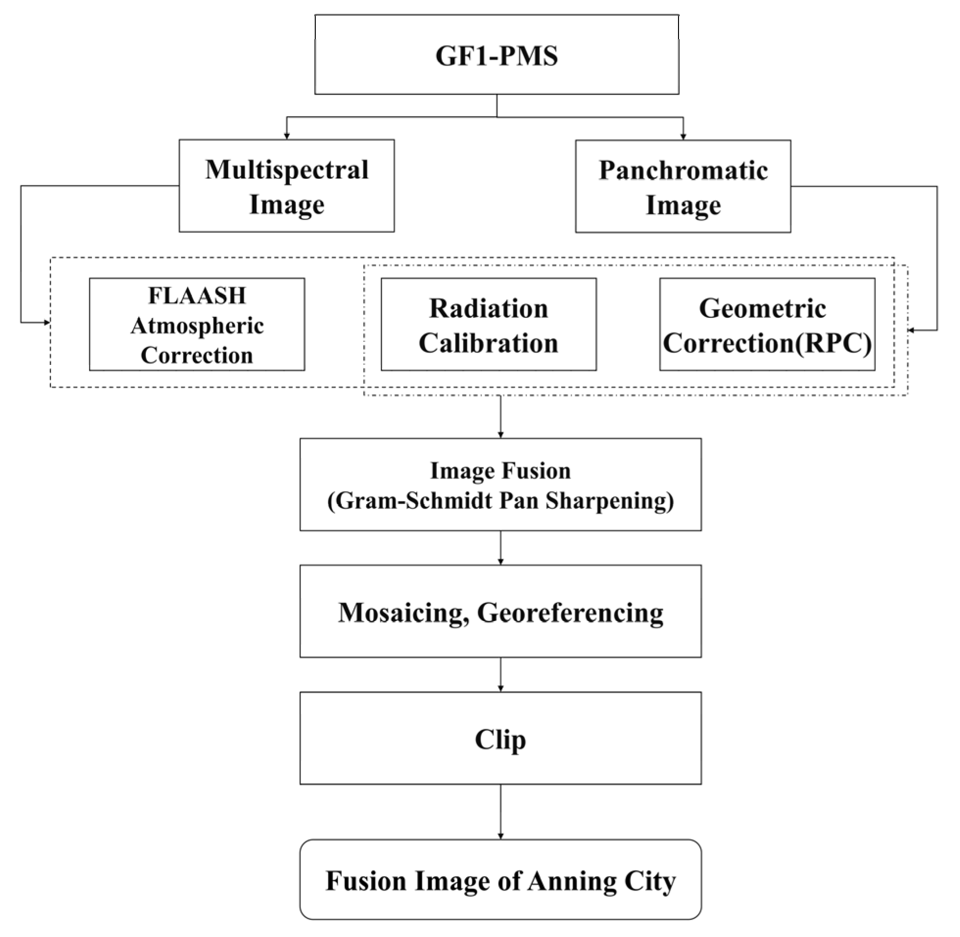
2.2. Data Source and Preprocessing
2.3. Methods
2.3.1. Vegetation Coverage Threshold Determination Method
2.3.2. Sensitivity Analysis
2.3.3. WUI Mapping
2.3.4. Accuracy Verification
3. Results
3.1. Parameter Thresholds for WUI Mapping
3.1.1. Threshold of FVC
3.1.2. Threshold of Vegetation Range Surrounding Building
3.2. Results of WUI Mapping
3.3. Accuracy Validation Results
3.4. Distribution Characteristics of the WUI
3.4.1. Quantity Characteristics
- (1)
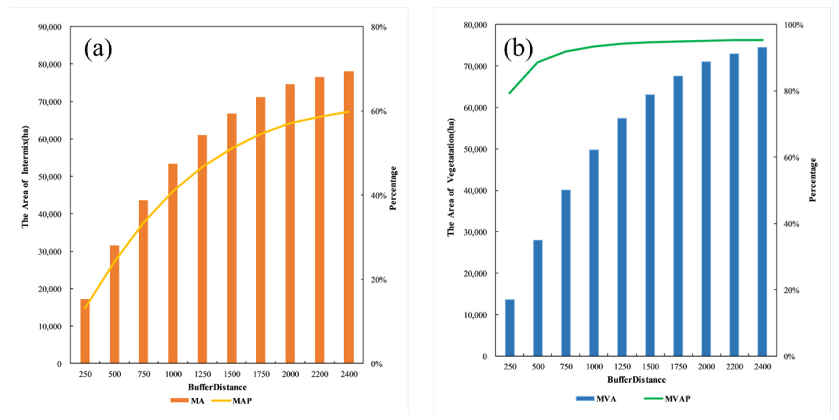
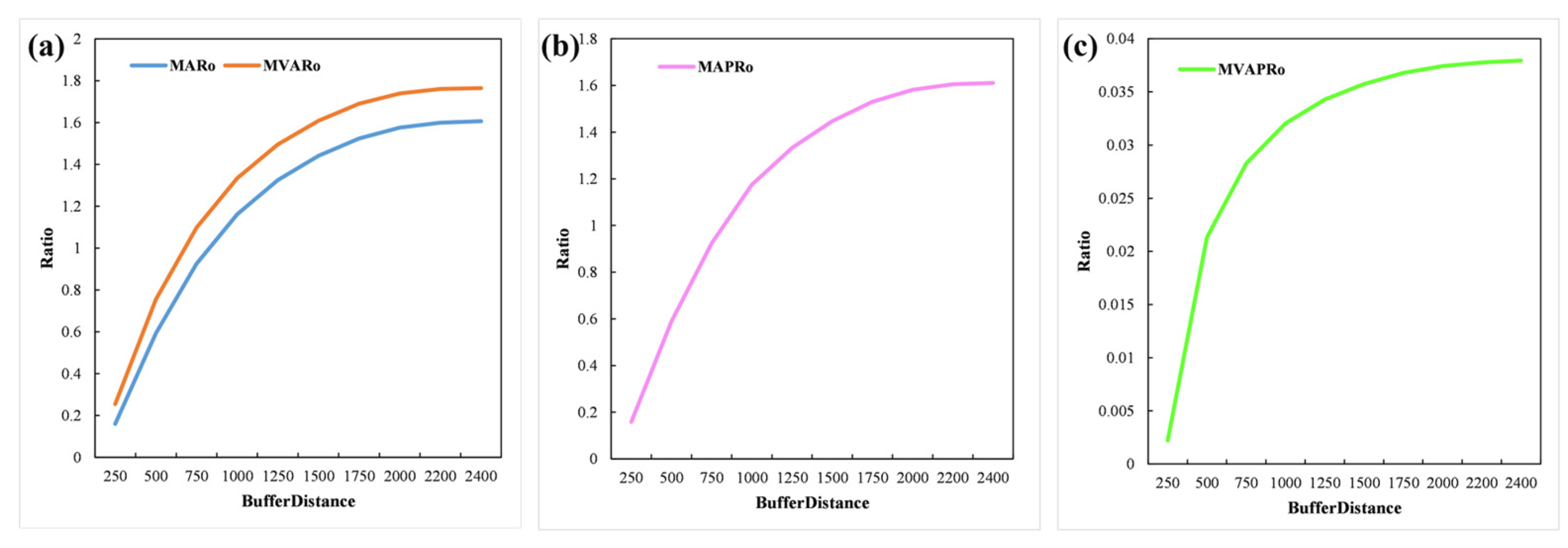
- Area of the intermix buildings and interface buildings in the WUI
- (2)
- Vegetation area in the WUI
- (3)
- Total area of the WUI
3.4.2. Spatial Distribution Characteristics
3.4.3. Distribution Relationship Between the WUI and MODIS Fire Spots
- (1)
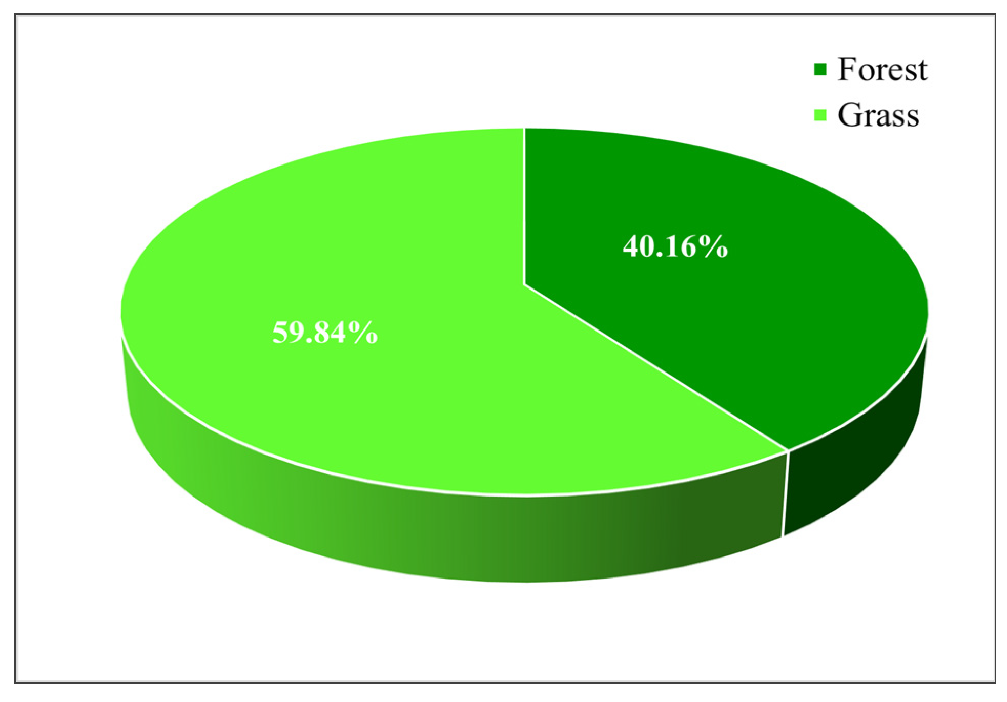
- Spatial distribution characteristics of forest, shrub, and grass fire spots
- (2)
- The association of the WUI with fire spots
4. Discussion
- (1)
- Parameter Differences of Calculation Method
- (2)
- Parameter Threshold Differences
- (3)
- Differences in the WUI Results
- (4)
- Relevance to Fire Indicators
- (5)
- Broader Applicability and Limitations of RS_ANWUI Method
5. Conclusions
- (1)
- Methodological Contribution
- (2)
- The Applicability in Anning City
- (3)
- Suggestions for Future Work
Author Contributions
Funding
Data Availability Statement
Conflicts of Interest
References
- Santosh, S.; Varun, J.; Chhetri, R.K. Forest fire as a potential environmental threat in recent years in Sikkim, Eastern Himalayas, India. Clim. Change Environ. Sustain. 2014, 2, 55–61. [Google Scholar]
- Syaufina, L.; Darojat, N.S.; Sitanggang, S.I. Forest fire as a threat for biodiversity and urban pollution. IOP Conf. Ser. Earth Environ. Sci. 2018, 203, 12015. [Google Scholar] [CrossRef]
- Wu, Y.Y.; Shu, L.F.; Wang, M.Y.; Zhang, H.; Si, Q.L. A review of forest fires in the world in recent years. Temp. For. Res. 2022, 5, 49–54. [Google Scholar]
- Blue Book of Carbon Emissions from Forest Fires; Chinese Academy of Sciences: Beijing, China, 2023.
- Boer, M.M.; Resco de Dios, V.; Bradstock, R.A. Unprecedented burn area of Australian mega forest fires. Nat. Clim. Change 2020, 10, 171–172. [Google Scholar] [CrossRef]
- Mengote, F. Paradise on Fire 2023 Maui-Lahaina Wildfire Case Study; The University of Arizona: Tucson, AZ, USA, 2024. [Google Scholar]
- Hammer, R.B.; Stewart, S.I.; Radeloff, V.C. Demographic trends, the wildland–urban interface, and wildfire management. Soc. Nat. Resour. 2009, 22, 777–782. [Google Scholar] [CrossRef]
- Woolcott, O.O. Los Angeles County in flames: Responsibilities on fire. Lancet Reg. Health–Am. 2025, 42, 101005. [Google Scholar] [CrossRef]
- Vacca, P.; Caballero, D.; Pastor, E.; Planas, E. WUI fire risk mitigation in Europe: A performance-based design approach at home-owner level. J. Saf. Sci. Resil. 2020, 1, 97–105. [Google Scholar] [CrossRef]
- Tang, W.; He, C.; Emmons, L.; Zhang, J. Global Expansion of Wildland-Urban Interface (WUI) and WUI Fires: Insights from a Multiyear Worldwide Unified Database (WUWUI). Environ. Res. Lett. 2024, 19, 44028. [Google Scholar] [CrossRef]
- Li, J.F. Reflections on the construction of forest fire fighting teams in urban mountain areas—Taking the construction of forest fire fighting teams in Lancheng Street, Longyang District, Yunnan Province as an example. Econ. Res. Guide 2014, 9, 53–54. [Google Scholar]
- Liu, J.; Li, T.; Jia, B.Q. Dynamics of tree canopy cover in rural settlements in the urban-rural transition zone of Beijing. J. Ecol. Rural Environ. 2019, 35, 1378–1386. [Google Scholar]
- Hou, J.N. Research on fire safety hazards and management countermeasures in urban-rural fringe areas. Fire Prot. Ind. 2020, 6, 74–75. [Google Scholar]
- Hou, X.J. Modeling and Analysis of Fire Risk in Urban-Forest Interface at Provincial Scale; University of Science and Technology of China: Beijing, China, 2018. [Google Scholar]
- Tian, X.R.; Zong, X.Z.; Wang, M.Y. Research progress on fire management in the wild-urban interface. J. For. Sci. 2023, 59, 149–158. [Google Scholar]
- Luo, D.; Wang, Q.F.; Chao, B.X.; L, L.; Hao, Z.Z.; L, Y.; Wang, C.; Wu, R.T.; Liu, F.P.; Pei, N.C. Fire risk evaluation at the stand scale in the forest-urban boundary area of the Guangzhou. For. Resour. Manag. 2023, 3, 56–64. [Google Scholar]
- Wang, Q.H.; Wang, J.; Li, X.N.; Ma, C.; Hong, R.C.; Cao, H.M.; Gao, Z.L. Research progress on forest-urban interface fire. J. Nanjing For. Univ. 2024, 48, 1–10. [Google Scholar]
- Jiang, F.; Qin, X.L.; Huang, S.S.; Hu, X.; Yang, X.; Meng, F. Analysis of spatiotemporal characteristics of forest, shrub and grass fire points across China based on MODIS data. J. Cent. South Univ. For. Technol. 2024, 44, 50–59. [Google Scholar]
- National Forest Fire Prevention Plan (2016–2025); No. 178; State Forestry Administration: Beijing, China, 2016.
- Li, S.; Dao, V.; Kumar, M.; Nguyen, P.; Banerjee, T. Mapping the wildland-urban interface in California using remote sensing data. Sci. Rep. 2022, 12, 5789. [Google Scholar] [CrossRef] [PubMed]
- Ketchpaw, A.R.; Li, D.; Khan, S.N.; Jiang, Y.; Li, Y.; Zhang, L. Using structure location data to map the Wildland–Urban interface in Montana, USA. Fire 2022, 5, 129. [Google Scholar] [CrossRef]
- Lampin, M.C.; Jappiot, M.; Long, M.; Bouillon, C.; Morge, D.; Ferrier, J.P. Mapping wildland-urban interfaces at large scales integrating housing density and vegetation aggregation for fire prevention in the South of France. J. Environ. Manag. 2010, 91, 732–741. [Google Scholar] [CrossRef]
- Soto, M.E.C.; Martínez, J.R.M.; Bonilla, S.; García, R.A.M. Calculating minimum safety distance against wildfires at the wildland-urban interface in Chile and Spain. Heliyon 2022, 8, e11238. [Google Scholar] [CrossRef]
- Carlson, A.R.; Helmers, D.P.; Hawbaker, T.J.; Mockrin, M.H.; Radeloff, V.C. The wildland–urban interface in the United States based on 125 million building locations. Ecol. Appl. 2022, 32, e2597. [Google Scholar] [CrossRef]
- Tikotzki, I.; Bar-Massada, A.; Levin, N. A geographically flexible approach for mapping the Wildland-Urban Interface integrating fire activity data. Front. Environ. Sci. 2023, 11, 1231490. [Google Scholar] [CrossRef]
- Bruno, B.; Sandra, O.; Mário, C.; Jorge, R. Mapping the wildland-urban interface at municipal level for wildfire exposure analysis in mainland Portugal. J. Environ. Manag. 2024, 368, 122098. [Google Scholar] [CrossRef] [PubMed]
- Schug, F.; Bar-Massada, A.; Carlson, A.R.; Cox, H.; Hawbaker, T.J.; Helmers, D.; Hostert, P.; Kaim, D.; Kasraee, N.K.; Martinuzzi, S.; et al. The global wildland–urban interface. Nature 2023, 621, 94–99. [Google Scholar] [CrossRef]
- Kramer, H.A.; Mockrin, M.H.; Alexandre, P.M.; Radeloff, V.C. High wildfire damage in interface communities in California. Int. J. Wildland Fire 2019, 28, 641–650. [Google Scholar] [CrossRef]
- Liang, X.; Liu, D.; Wang, Z.; Wang, J. Characterizing the dynamics of wildland-urban interface and the potential impacts on fire activity in Alaska from 2000 to 2010. Landsc. Urban Plan. 2022, 228, 104553. [Google Scholar] [CrossRef]
- Radeloff, V.C.; Hammer, R.B.; Stewart, S.I.; Fried, J.S.; Holcomb, S.S.; McKeefry, J.F. The wildland–urban interface in the United States. Ecol. Appl. 2005, 15, 799–805. [Google Scholar] [CrossRef]
- Li, X.; Gong, P.; Zhou, Y.; Wang, J.; Bai, Y.; Chen, B.; Hu, T.; Xiao, Y.; Xu, B.; Yang, J.; et al. Mapping global urban boundaries from the global artificial impervious area (GAIA) data. Environ. Res. Lett. 2020, 15, 94044. [Google Scholar] [CrossRef]
- Sen, S.; Cohen, A.S. Sample size requirements for applying diagnostic classification models. Front. Psychol. 2021, 11, 621251. [Google Scholar] [CrossRef]


| Sample Catagory | Interface Samples | Intermix Samples | Non-WUI Samples |
|---|---|---|---|
| Interface Samples | 245 | 31 | 24 |
| Intermix Samples | 15 | 261 | 24 |
| Non-WUI Samples | 5 | 4 | 291 |
| Precision | 81.67% | 87.00% | 97.00% |
| Recall | 92.45% | 88.18% | 85.84% |
| F1-Score | 0.87 | 0.88 | 0.91 |
| Accuracy | 88.56% | ||
| Kappa | 0.83 | ||
| Building Types | Area (ha) | The Proportion to the Total Area of the Anning City (%) | The Proportion to Total Building Area in Anning City (%) | The Proportion to the WUI Area (%) |
|---|---|---|---|---|
| Intermix | 3584.28 | 2.75 | 32.68 | 20.74 |
| Interface | 7375.65 | 5.67 | 67.24 | 22.84 |
| Vegetation Type | Area (ha) | The Proportion to the Total Area of the Anning City (%) | The Proportion to Total Vegetation Area in Anning City (%) | The Proportion to the WUI Area (%) |
|---|---|---|---|---|
| Intermix | 13,699.65 | 10.52 | 16.90 | 79.26 |
| Interface | 24,918.47 | 19.14 | 30.74 | 77.16 |
| Method Name | Total Area of the WUI (ha) | Intermix Area(ha) | Interface Area(ha) | Percentage of Intermix to the City’s Area(%) | Percentage of Interface to the City’s Area(%) |
|---|---|---|---|---|---|
| RS_ANWUI | 49,578.05 | 17,283.93 | 32,294.12 | 13.28 | 24.80 |
| Schug | 34,690.42 | 10,821.93 | 23,868.49 | 8.32 | 18.33 |
| Method Name | Percentage of Fire Spots in Intermix Area (%) | Percentage of Fire Spots in Interface Area (%) | Intermix Fire Perimeter (ha) | Interface Fire Perimeter (ha) |
|---|---|---|---|---|
| RS_ANWUI | 6.30 | 27.56 | 184.09 | 931.86 |
| Schug | 3.15 | 9.45 | 35.6 | 160.99 |
Disclaimer/Publisher’s Note: The statements, opinions and data contained in all publications are solely those of the individual author(s) and contributor(s) and not of MDPI and/or the editor(s). MDPI and/or the editor(s) disclaim responsibility for any injury to people or property resulting from any ideas, methods, instructions or products referred to in the content. |
© 2025 by the authors. Licensee MDPI, Basel, Switzerland. This article is an open access article distributed under the terms and conditions of the Creative Commons Attribution (CC BY) license (https://creativecommons.org/licenses/by/4.0/).
Share and Cite
Jiang, F.; Hu, X.; Qin, X.; Huang, S.; Meng, F. Methodology for Wildland–Urban Interface Mapping in Anning City Using High-Resolution Remote Sensing. Land 2025, 14, 1141. https://doi.org/10.3390/land14061141
Jiang F, Hu X, Qin X, Huang S, Meng F. Methodology for Wildland–Urban Interface Mapping in Anning City Using High-Resolution Remote Sensing. Land. 2025; 14(6):1141. https://doi.org/10.3390/land14061141
Chicago/Turabian StyleJiang, Feng, Xinyu Hu, Xianlin Qin, Shuisheng Huang, and Fangxin Meng. 2025. "Methodology for Wildland–Urban Interface Mapping in Anning City Using High-Resolution Remote Sensing" Land 14, no. 6: 1141. https://doi.org/10.3390/land14061141
APA StyleJiang, F., Hu, X., Qin, X., Huang, S., & Meng, F. (2025). Methodology for Wildland–Urban Interface Mapping in Anning City Using High-Resolution Remote Sensing. Land, 14(6), 1141. https://doi.org/10.3390/land14061141