

Automated Global Method to Detect Rapid and Future Urban Areas


Abstract
1. Introduction
2. Materials and Methods
2.1. Data
2.2. Study Sites
2.3. Methods
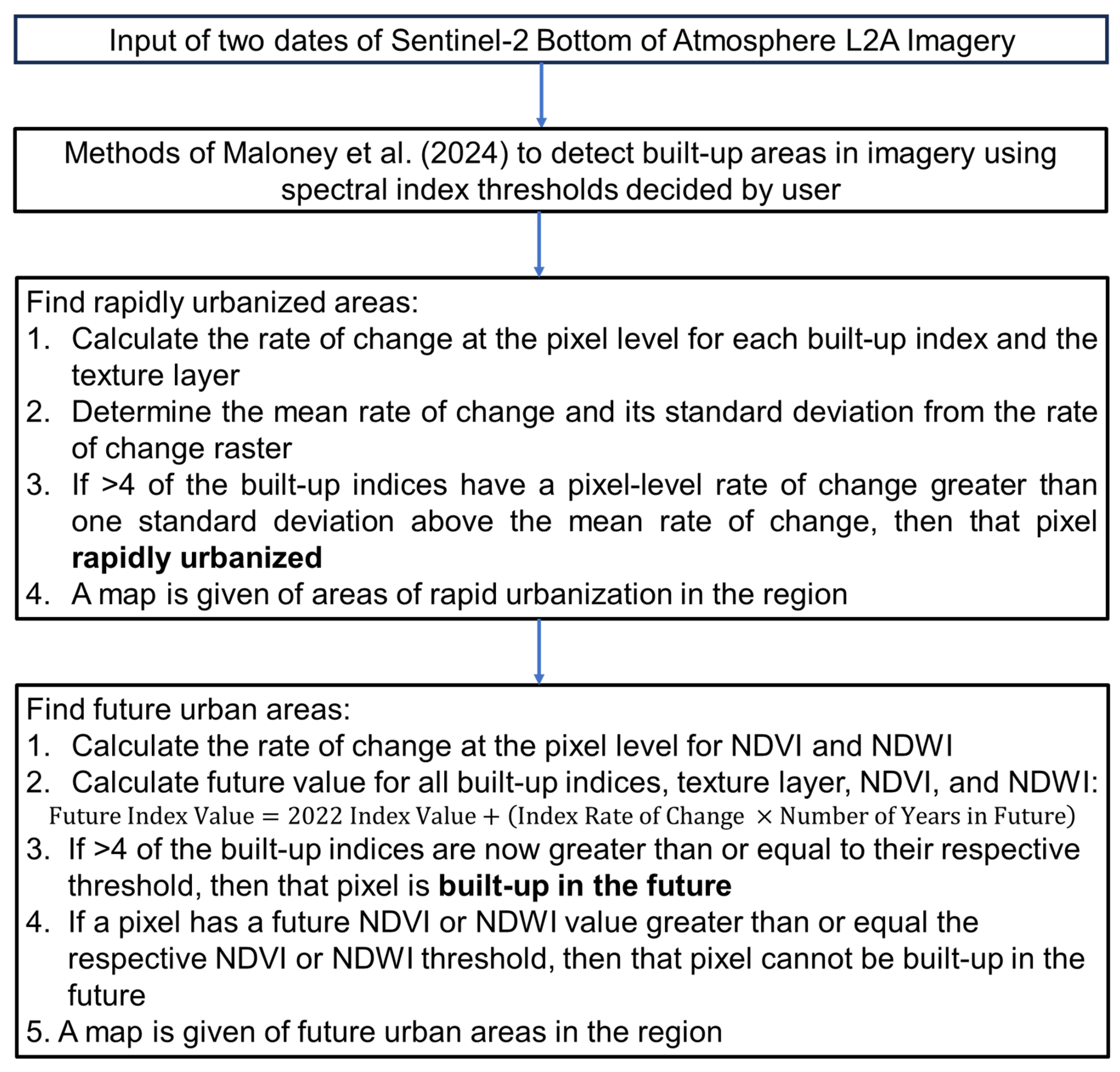
2.3.1. Automated Method for Built-Up Land Cover Identification
2.3.2. Preliminaries Prior to Algorithm Development
2.3.3. Rapid Urbanization Algorithm
2.3.4. Future Urbanization Algorithm
3. Results
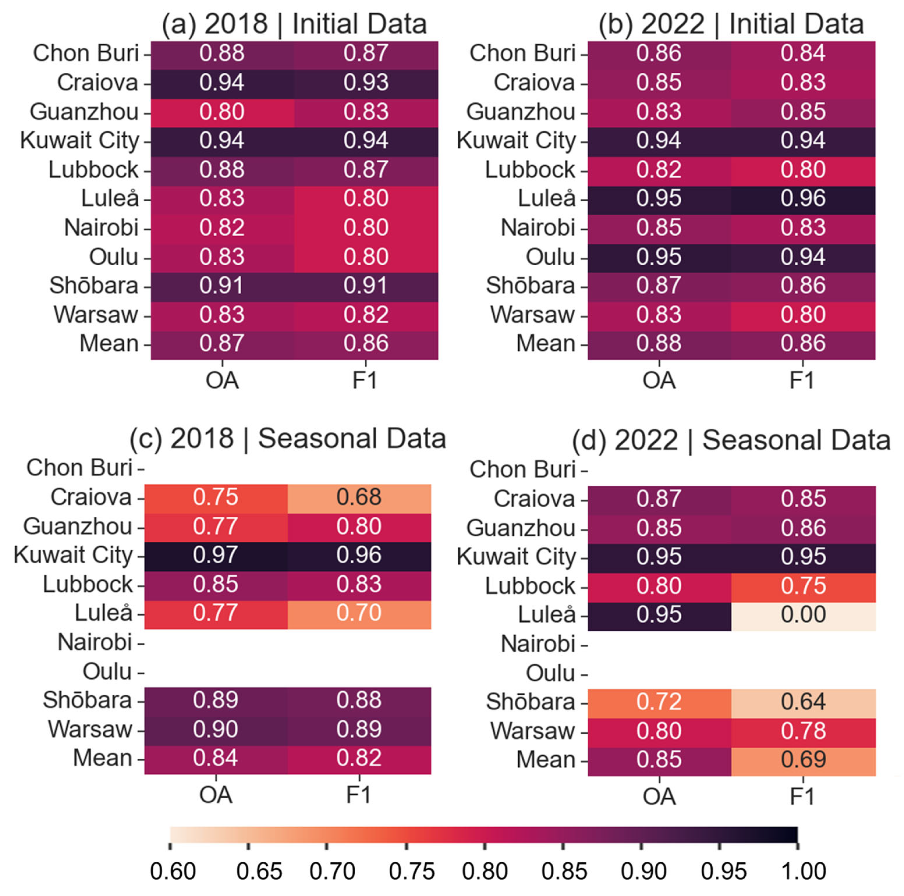
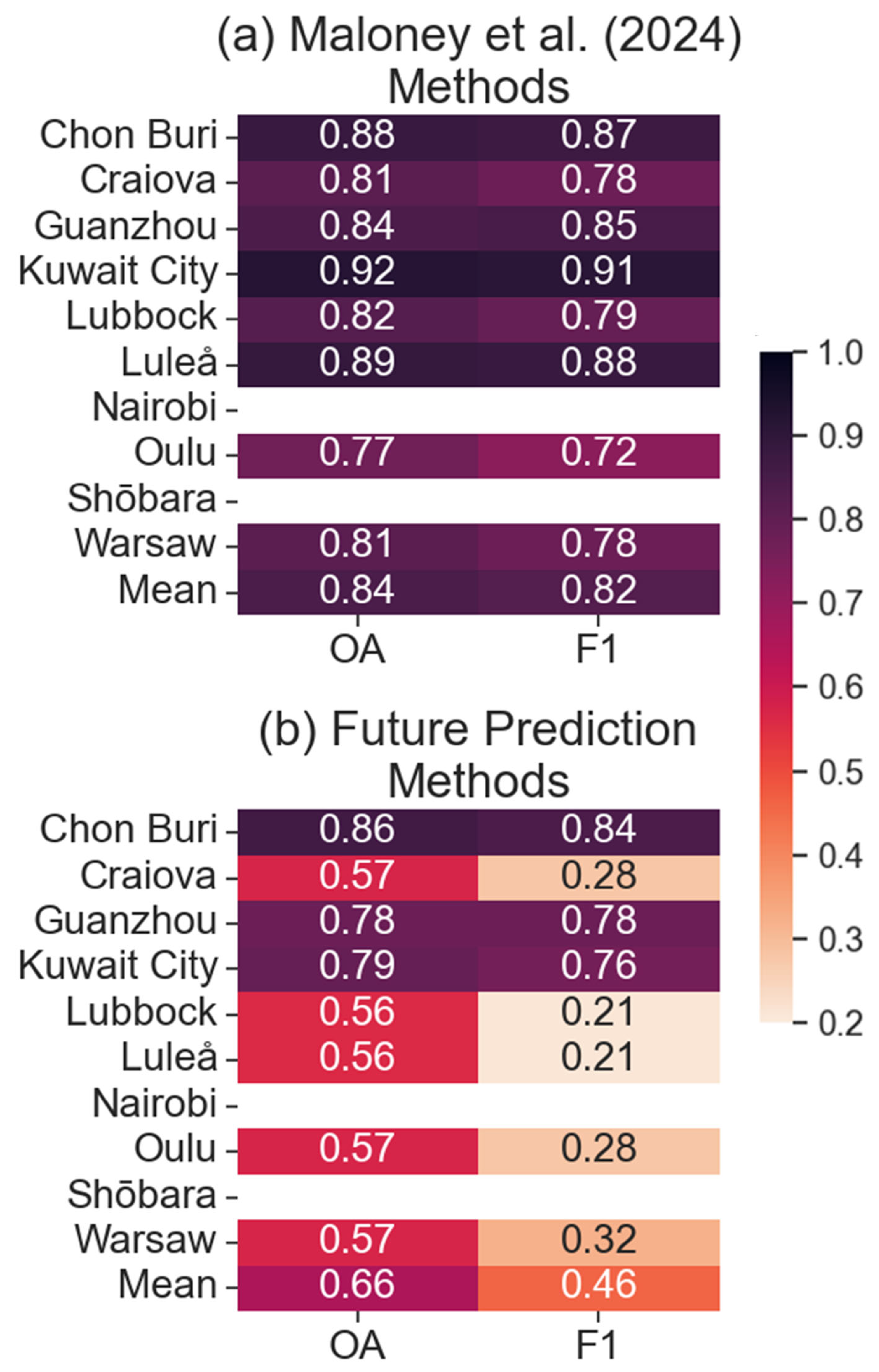
3.1. Accuracy Results
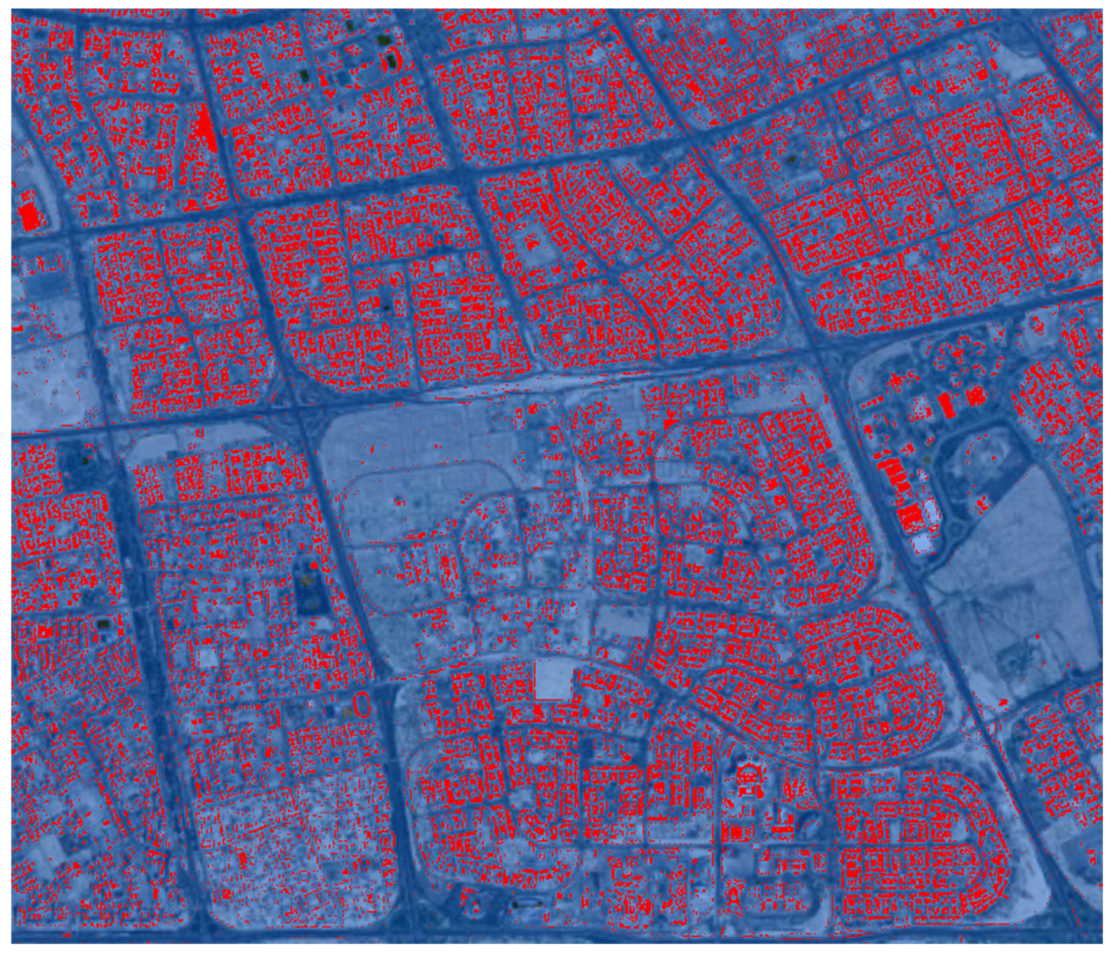
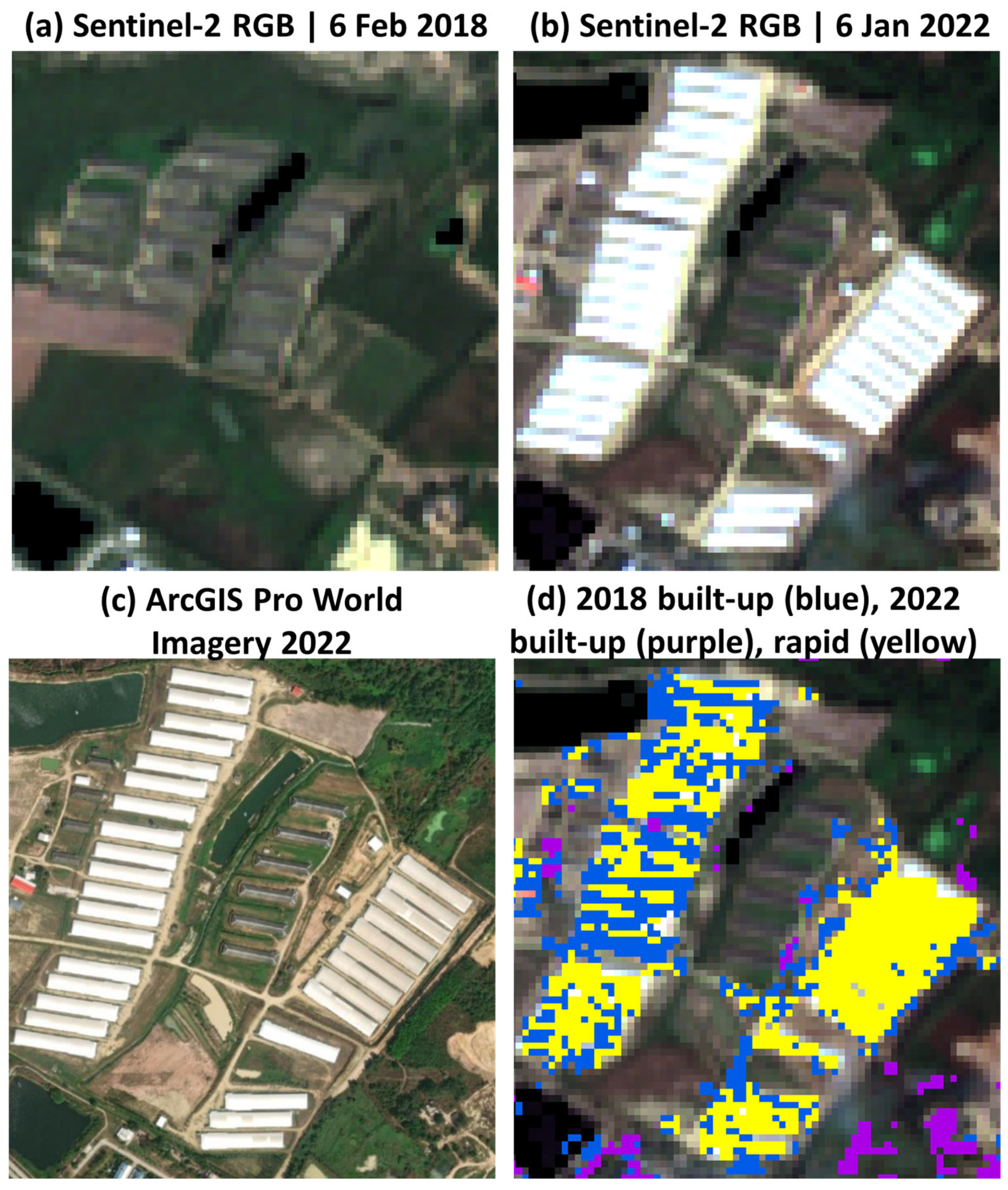
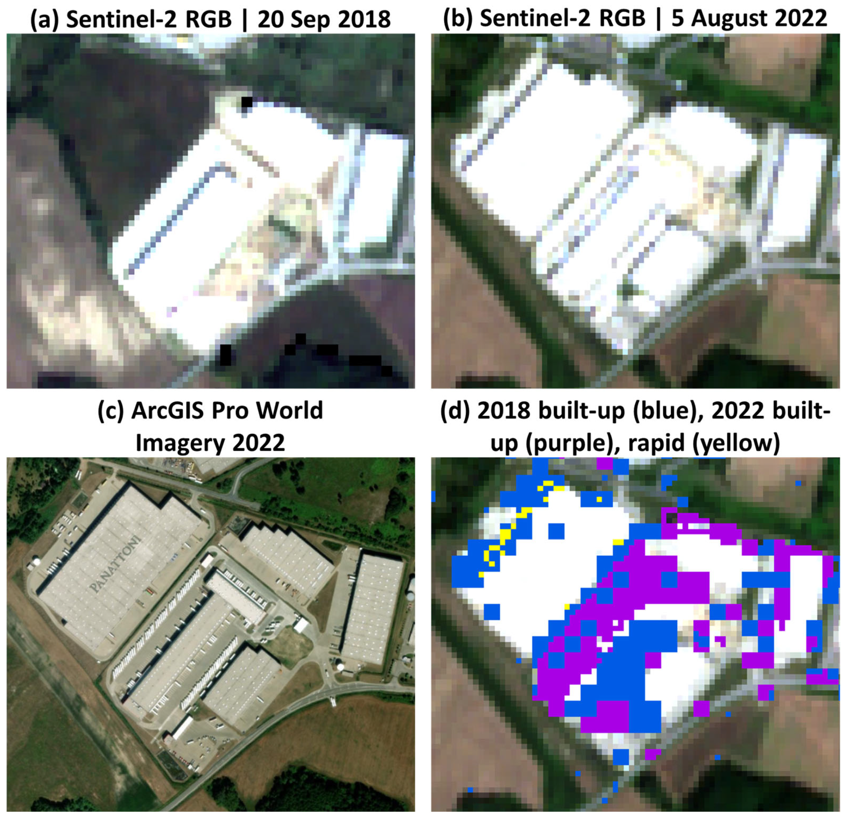
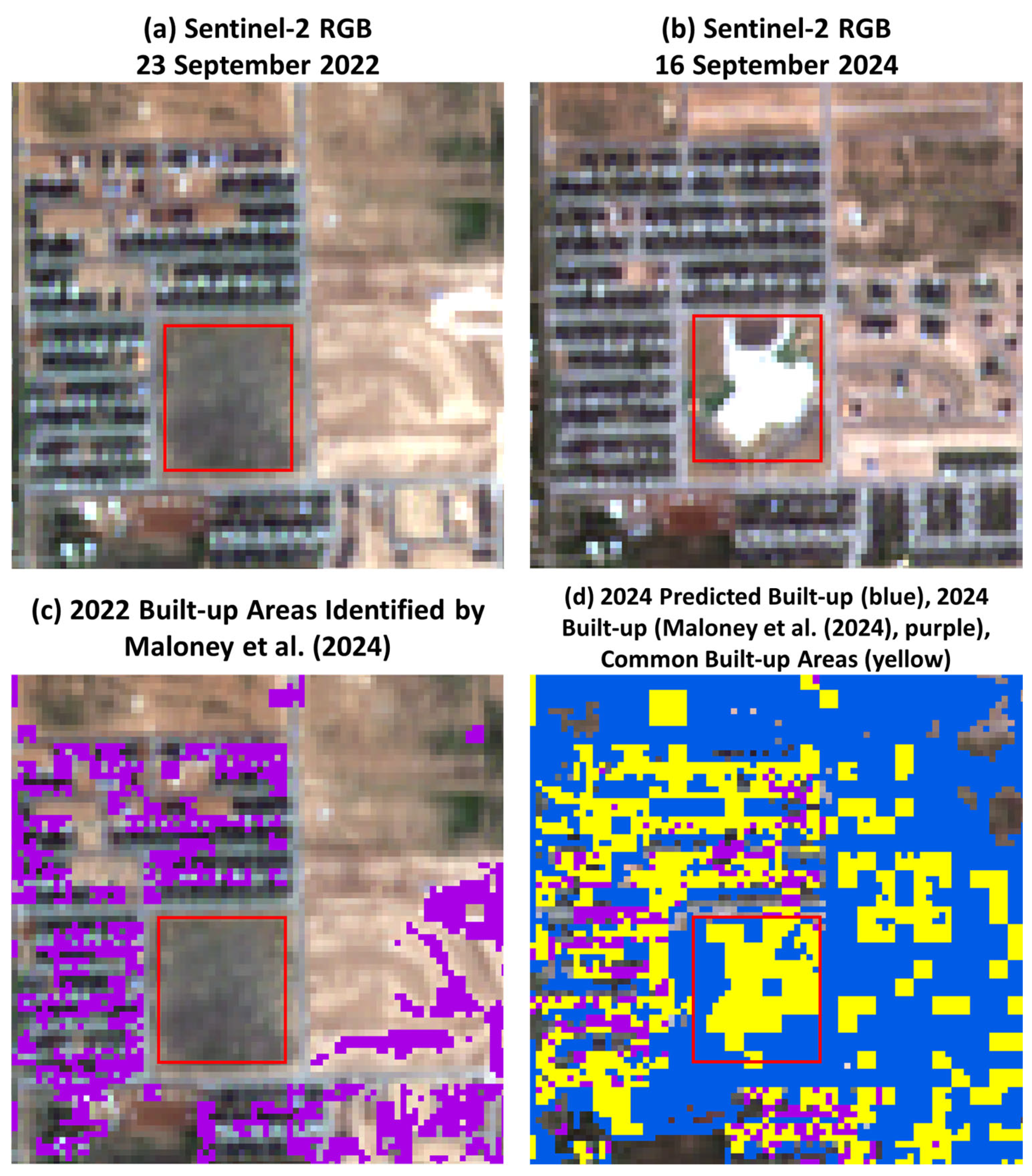
3.2. Rapid Urbanization
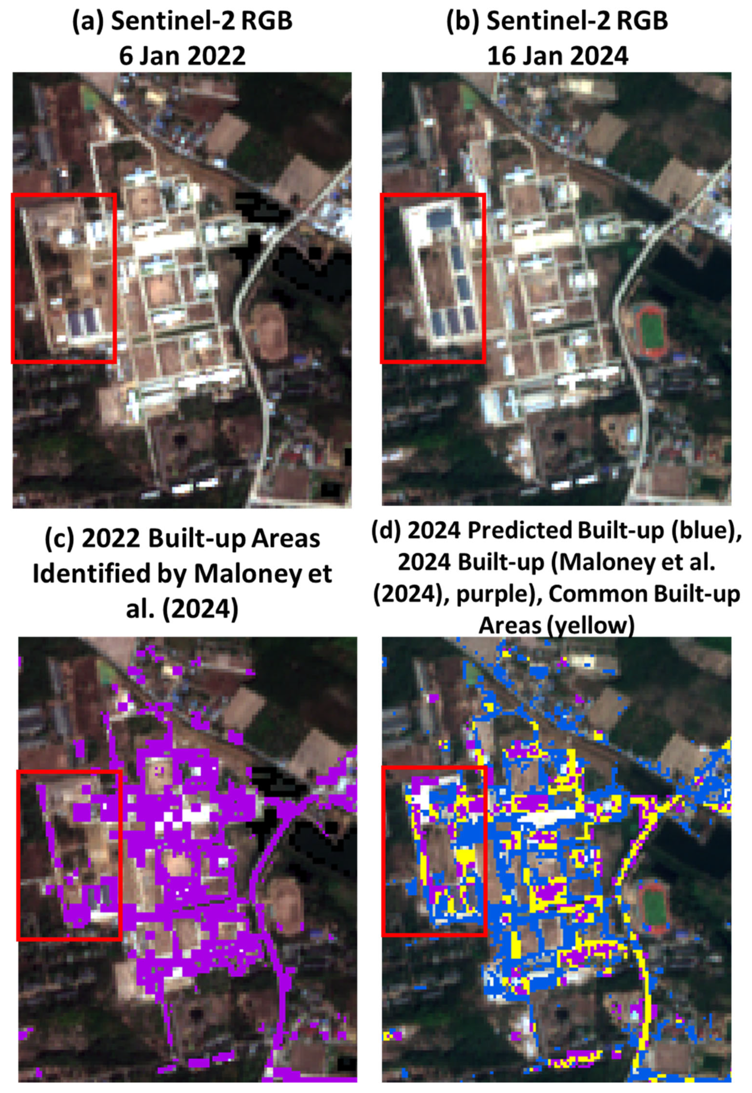
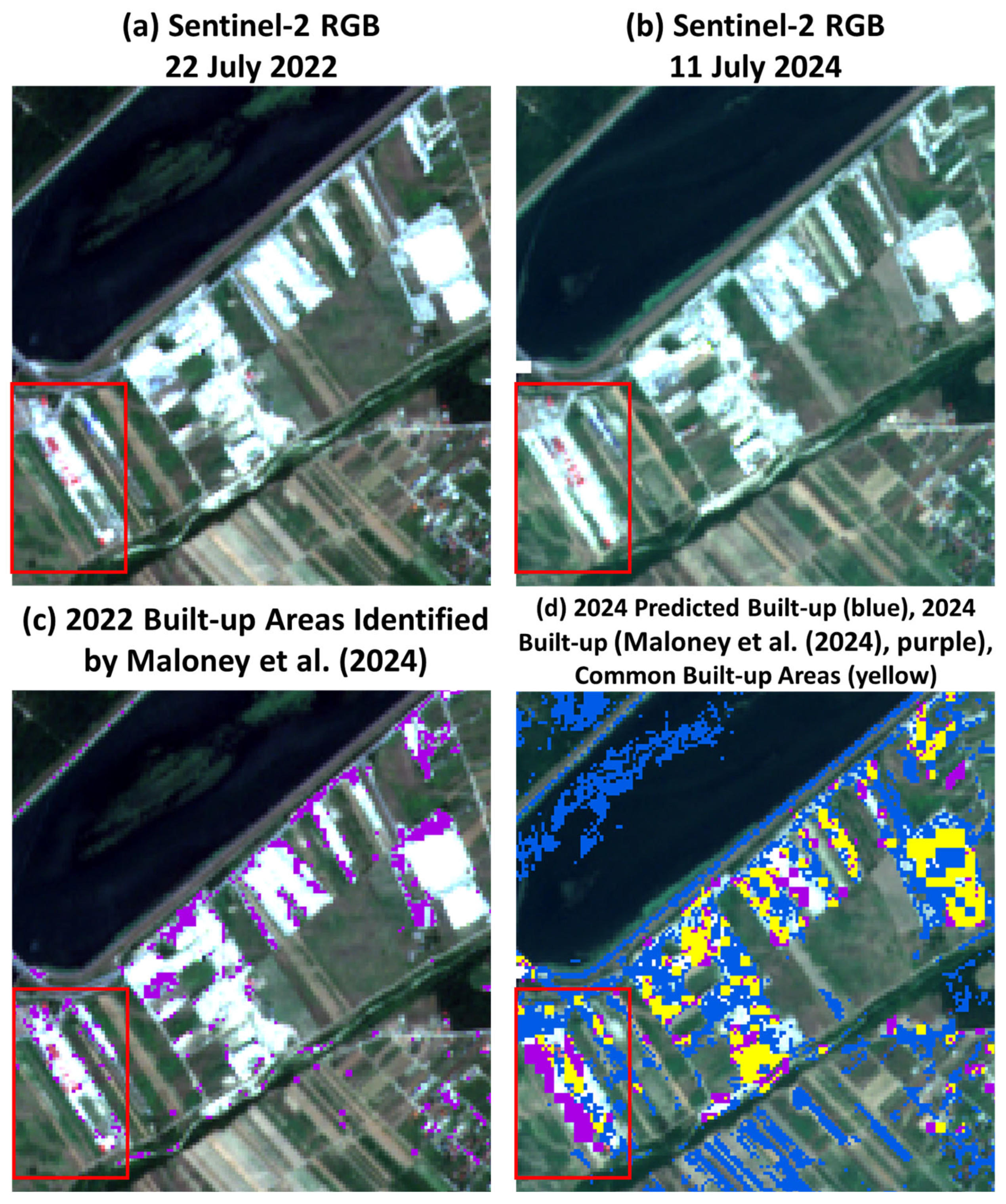
3.3. Future Urbanization
4. Discussion and Conclusions
Author Contributions
Funding
Institutional Review Board Statement
Informed Consent Statement
Data Availability Statement
Acknowledgments
Conflicts of Interest
References
- Grimm, N.B.; Faeth, S.H.; Golubiewski, N.E.; Redman, C.L.; Wu, J.; Bai, X.; Briggs, J.M. Global change and the ecology of cities. Science 2008, 319, 756–760. [Google Scholar] [CrossRef] [PubMed]
- Taha, H. Urban climates and heat islands: Albedo, evapotranspiration, and anthropogenic heat. Energ. Build. 1997, 25, 99–103. [Google Scholar] [CrossRef]
- Sussman, H.S.; Dai, A.; Roundy, P.E. The controlling factors of urban heat in Bengaluru, India. Urban Clim. 2021, 38, 100881. [Google Scholar] [CrossRef]
- Kovats, R.S.; Hajat, S. Heat stress and public health: A critical review. Annu. Rev. Public Health 2008, 29, 41–55. [Google Scholar] [CrossRef]
- Li, X.; Zhou, Y.; Yu, S.; Jia, G.; Li, H.; Li, W. Urban heat island impacts on building energy consumption: A review of approaches and findings. Energy 2019, 174, 407–419. [Google Scholar] [CrossRef]
- Wang, Y.; Zhao, T. Impacts of urbanization-related factors on CO2 emissions: Evidence from China’s three regions with varied urbanization levels. Atmos. Pollut. Res. 2018, 9, 15–26. [Google Scholar] [CrossRef]
- Heaviside, C.; Macintyre, H.; Vardoulakis, S. The urban heat island: Implications for health in a changing environment. Curr. Environ. Health Rep. 2017, 4, 296–305. [Google Scholar] [CrossRef]
- Zetter, R.; Deikun, G. Meeting humanitarian challenges in urban areas. Forced Migr. Rev. 2010, 34, 5–7. Available online: https://library.alnap.org/system/files/content/resource/files/main/zetter-deikun-05-07.pdf (accessed on 3 February 2025).
- Kilcullen, D.J. The city as a system: Future conflict and urban resilience. In The Fletcher Forum of World Affairs; The Fletcher Law School of Law and Diplomacy: Medford, MA, USA, 2012; pp. 19–39. Available online: https://www.jstor.org/stable/45289555 (accessed on 3 February 2025).
- Tang, J.; Di, L.; Rahman, M.S.; Yu, Z. Spatial-temporal landscape pattern change under rapid urbanization. J. Appl. Remote Sens. 2019, 13, 024503. [Google Scholar] [CrossRef]
- Yuan, F.; Sawaya, K.E.; Loeffelholz, B.C.; Bauer, M.E. Land cover classification and change analysis of the Twin Cities (Minnesota) Metropolitan Area by multitemporal Landsat remote sensing. Remote Sens. Environ. 2005, 98, 317–328. [Google Scholar] [CrossRef]
- Akbar, T.A.; Hassan, Q.K.; Ishaq, S.; Batool, M.; Butt, H.J.; Jabbar, H. Investigative spatial distribution and modelling of existing and future urban land changes and its impact on urbanization and economy. Remote Sens. 2019, 11, 105. [Google Scholar] [CrossRef]
- Hasan, S.; Deng, X.; Li, Z.; Chen, D. Projections of future land use in Bangladesh under the background of baseline, ecological protection and economic development. Sustainability 2017, 9, 505. [Google Scholar] [CrossRef]
- Dadhich, P.N.; Hanaoka, S. Remote sensing, GIS and Markov’s method for land use change detection and prediction of Jaipur district. J. Geomat. 2010, 4, 9–15. [Google Scholar]
- Han, J.; Hayashi, Y.; Cao, X.; Imura, H. Application of an integrated system dynamics and cellular automata model for urban growth assessment: A case study of Shanghai, China. Landsc. Urban Plan. 2009, 91, 133–141. [Google Scholar] [CrossRef]
- Tripathy, P.; Kumar, A. Monitoring and modelling spatio-temporal urban growth of Delhi using cellular automata and geoinformatics. Cities 2019, 90, 52–63. [Google Scholar] [CrossRef]
- Liu, Y.; Hu, Y.; Long, S.; Liu, L.; Liu, X. Analysis of the effectiveness of urban-land-use-change models based on the measurement of spatio-temporal, dynamic urban growth: A cellular automata case study. Sustainability 2017, 9, 796. [Google Scholar] [CrossRef]
- Baqa, M.F.; Chen, F.; Lu, L.; Qureshi, S.; Tariq, A.; Wang, S.; Jing, L.; Hamza, S.; Li, Q. Monitoring and modeling the patterns and trends of urban growth using urban sprawl matrix and CA-Markov model: A case study of Karachi, Pakistan. Land 2021, 10, 700. [Google Scholar] [CrossRef]
- Yaagoubi, R.; Lakber, C.E.; Miky, Y. A comparative analysis on the use of a cellular automata Markov chain versus a convolutional LSTM model in forecasting urban growth using Sentinel 2A images. J. Land Use Sci. 2024, 19, 258–277. [Google Scholar] [CrossRef]
- Amir Siddique, M.; Wang, Y.; Xu, N.; Ullah, N.; Zeng, P. The spatiotemporal implications of urbanization for urban heat islands in Beijing: A predictive approach based on CA–Markov modeling (2004–2050). Remote Sens. 2021, 13, 4697. [Google Scholar] [CrossRef]
- Frimpong, B.F.; Molkenthin, F. Tracking urban expansion using random forests for the classification of Landsat imagery (1986–2015) and predicting urban/built-up areas for 2025: A study of the Kumasi Metropolis, Ghana. Land 2021, 10, 44. [Google Scholar] [CrossRef]
- Karimi, F.; Sultana, S.; Babakan Shirzadi, A.; Suthaharan, S. An enhanced support vector machine model for urban expansion prediction. Comput. Environ. Urban Syst. 2019, 75, 61–75. [Google Scholar] [CrossRef]
- Zhou, L.; Dang, X.; Sun, Q.; Wang, S. Multi-scenario simulation of urban land change in Shanghai by random forest and CA-Markov model. Sustain. Cities Soc. 2020, 55, 102045. [Google Scholar] [CrossRef]
- Gounaridis, D.; Chorianopoulos, I.; Symeonakis, E.; Koukoulas, S. A random forest-cellular automata modelling approach to explore future land use/cover change in Attica (Greece), under different socio-economic realities and scales. Sci. Total Environ. 2019, 646, 320–335. [Google Scholar] [CrossRef]
- Wang, J.; Hadjikakou, M.; Hewitt, R.J.; Bryan, B.A. Simulating large-scale urban land-use patterns and dynamics using the U-Net deep learning architecture. Comput. Environ. Urban Syst. 2022, 97, 101855. [Google Scholar] [CrossRef]
- Jozdani, S.E.; Johnson, B.A.; Chen, D. Comparing deep neural networks, ensemble classifiers, and support vector machine algorithms for object-based urban land use/land cover classification. Remote Sens. 2019, 11, 1713. [Google Scholar] [CrossRef]
- Maloney, M.C.; Becker, S.J.; Griffin, A.W.H.; Lyon, S.L.; Lasko, K. Automated built-up infrastructure land cover extraction using index ensembles with machine learning, automated training data, and red band texture layers. Remote Sens. 2024, 16, 868. [Google Scholar] [CrossRef]
- Slonecker, E.T.; Jennings, D.B.; Garofalo, D. Remote sensing of impervious surfaces: A review. Remote Sens. Rev. 2001, 20, 227–255. [Google Scholar] [CrossRef]
- Weng, Q. Remote sensing of impervious surfaces in the urban areas: Requirements, methods, and trends. Remote Sens. Environ. 2012, 117, 34–49. [Google Scholar] [CrossRef]
- Zha, Y.; Gao, J.; Ni, S. Use of normalized difference built-up index in automatically mapping urban areas from TM Imagery. Int. J. Remote Sens. 2003, 24, 583–594. [Google Scholar] [CrossRef]
- Department of the Army. In Combined Arms Operations in Urban Terrain (FM 3-06.11); Department of the Army: Washington DC, USA, 2002; pp. 1–2. Available online: https://www.bits.de/NRANEU/others/amd-us-archive/fm3-06.11%2802%29.pdf (accessed on 10 February 2025).
- World Bank Group. East Asia’s Changing Urban Landscape: Measuring a Decade of Spatial Growth; The World Bank: Washington, DC, USA, 2015; Available online: https://hdl.handle.net/10986/21159 (accessed on 10 February 2025).
- Nairobi Swells with Urban Growth. Available online: https://earthobservatory.nasa.gov/images/88822/nairobi-swells-with-urban-growth (accessed on 20 November 2024).
- Mahgoub, Y. Globalization and the built environment in Kuwait. Habitat Int. 2004, 28, 505–519. [Google Scholar] [CrossRef]
- Rasul, A.; Baltzer, H.; Ibrahim, G.; Hameed, H.; Wheeler, J.; Adamu, B.; Ibrahim, S.; Najmaddin, P. Applying built-up and bare-soil indices from Landsat 8 to cities in dry climates. Land 2018, 7, 81. [Google Scholar] [CrossRef]
- Sokienah, Y. Globalization’s impact on the usages of imported and local building materials in Jordan. Int. J. Innov. Technol. Explor. Eng. 2019, 8, 971–975. [Google Scholar] [CrossRef]
- Becker, S.J.; Maloney, M.C.; Griffin, A.W.H.; Lasko, K.; Sussman, H.S. Bare ground classification using a spectral index ensemble and machine learning models optimized across 12 international study sites. Geocarto Int. 2025, 40, 1. [Google Scholar] [CrossRef]
- Kaur, R.; Pandey, P. A review on spectral indices for built-up area extraction using remote sensing technology. Arab J Geosci 2022, 15, 391. [Google Scholar] [CrossRef]
- Panattoni Europe. Available online: https://panattonieurope.com/en-pl/newsroom/panattoni-park-pruszkow-iv-upcoming-speculative-2 (accessed on 23 January 2025).
- Langenkamp, J.-P.; Rienow, A. Exploring the Use of Orthophotos in Google Earth Engine for Very High-Resolution Mapping of Impervious Surfaces: A Data Fusion Approach in Wuppertal, Germany. Remote. Sens. 2023, 15, 1818. [Google Scholar] [CrossRef]
- Lasko, K.; Maloney, M.C.; Becker, S.J.; Griffin, A.W.H.; Lyon, S.L.; Griffin, S.P. Automated training data Ggeneration from spectral indexes for mapping surface water extent with Sentinel-2 satellite imagery at 10 m and 20 m resolutions. Remote Sens. 2021, 13, 4531. [Google Scholar] [CrossRef]


| Band Name | Band Center (nm) | Band Width (nm) | Band Number | Resolution (m) |
|---|---|---|---|---|
| Blue | 492.4 | 66 | 02 | 10 |
| Green | 559.8 | 36 | 03 | 10 |
| Red | 664.6 | 31 | 04 | 10 |
| Near-infrared (NIR) | 832.8 | 106 | 08 | 10 |
| Shortwave Infrared (SWIR) | 1613.7 | 91 | 11 | 20 |
| Built-Up Category | Population |
|---|---|
| Village | <3000 |
| Town | 3000–100,000 |
| City | 100,000–1,000,000 |
| Metropolis | 1,000,000–10,000,000 |
| Megalopolis | >10,000,000 |
| Study Site | Granule ID | Collection Dates | Köppen Climate Classification | Built-Up Category |
|---|---|---|---|---|
| Guangzhou, China | T49QGF | 11 October 2018, 2 October 2022 | Temperate | Megalopolis |
| Shōbara, Japan | T53SLU | 29 April 2018, 28 April 2022 | Temperate | Town |
| Kuwait City, Kuwait | T38RQT | 21 May 2018, 20 May 2022 | Arid | Metropolis |
| Lubbock, Texas, United States | T13SGT | 23 September 2018, 22 September 2022 | Arid | City |
| Nairobi, Kenya | T37MBU | 29 January 2018, 13 January 2022 | Tropical | Metropolis |
| Chon Buri, Thailand | T47PQQ | 6 February 2018, 6 January 2022 | Tropical | Metropolis |
| Warsaw, Poland | T34UDC | 20 September 2018, 5 August 2022 | Continental | Metropolis |
| Craiova, Romania | T34TGQ | 3 July 2018, 22 July 2022 | Continental | City |
| Oulu, Finland | T35WMN | 26 May 2018, 29 June 2022 | Polar | City |
| Luleå, Sweden | T34WET | 11 July 2018, 27 June 2022 | Polar | Town |
| Index | Optimal Global Threshold |
|---|---|
| NDBI | −0.08 |
| BAEI | 0.31 |
| VBI-sh | 0.20 |
| BRBA | 0.40 |
| IBI-adj | −0.05 |
| NDVI | 0.35 |
| NDWI | 0.15 |
| Study Site | Collection Dates |
|---|---|
| Chon Buri, Thailand | N/A |
| Craiova, Romania | 30 March 2018, 24 March 2022 |
| Guangzhou, China | 21 March 2018, 9 April 2022 |
| Kuwait City, Kuwait | 18 October 2018, 22 October 2022 |
| Lubbock, Texas | 2 March 2018, 26 March 2022 |
| Luleå, Sweden | 19 October 2018, 23 October 2022 |
| Nairobi, Kenya | N/A |
| Oulu, Finland | N/A |
| Shōbara, Japan | 21 October 2018, 30 September 2022 |
| Warsaw, Poland | 8 April 2018, 23 March 2022 |
| Study Site | Collection Date |
|---|---|
| Chon Buri, Thailand | 16 January 2024 |
| Craiova, Romania | 11 July 2024 |
| Guangzhou, China | 11 October 2024 |
| Kuwait City, Kuwait | 19 May 2024 |
| Lubbock, Texas | 16 September 2024 |
| Luleå, Sweden | 21 July 2024 |
| Nairobi, Kenya | N/A |
| Oulu, Finland | 24 May 2024 |
| Shōbara, Japan | N/A |
| Warsaw, Poland | 14 August 2024 |
| City | NDBI | IBI-adj | BRBA | BAEI | VBI-sh | Texture | NDVI | NDWI |
|---|---|---|---|---|---|---|---|---|
| Chon Buri, Thailand | -- | -- | -- | -- | -- | -- | -- | -- |
| Craiova, Romania | -- | -- | -- | -- | -- | -- | -- | 0.00 |
| Guangzhou, China | -- | -- | -- | -- | -- | -- | -- | -- |
| Kuwait City, Kuwait | -- | −0.10 | 0.70 | 0.51 | -- | -- | 0.30 | 0.00 |
| Lubbock, Texas | -- | -- | -- | -- | -- | -- | 0.26 | -- |
| Luleå, Sweden | -- | -- | -- | -- | -- | -- | 0.30 | 0.00 |
| Nairobi, Kenya | -- | -- | 0.36 | 0.15 | -- | -- | -- | -- |
| Oulu, Finland | -- | -- | -- | -- | -- | -- | 0.25 | 0.00 |
| Shōbara, Japan | -- | -- | -- | -- | -- | -- | 0.28 | −0.05 |
| Warsaw, Poland | -- | -- | -- | -- | -- | -- | -- | 0.00 |
Disclaimer/Publisher’s Note: The statements, opinions and data contained in all publications are solely those of the individual author(s) and contributor(s) and not of MDPI and/or the editor(s). MDPI and/or the editor(s) disclaim responsibility for any injury to people or property resulting from any ideas, methods, instructions or products referred to in the content. |
© 2025 by the authors. Licensee MDPI, Basel, Switzerland. This article is an open access article distributed under the terms and conditions of the Creative Commons Attribution (CC BY) license (https://creativecommons.org/licenses/by/4.0/).
Share and Cite
Sussman, H.S.; Becker, S.J. Automated Global Method to Detect Rapid and Future Urban Areas. Land 2025, 14, 1061. https://doi.org/10.3390/land14051061
Sussman HS, Becker SJ. Automated Global Method to Detect Rapid and Future Urban Areas. Land. 2025; 14(5):1061. https://doi.org/10.3390/land14051061
Chicago/Turabian StyleSussman, Heather S., and Sarah J. Becker. 2025. "Automated Global Method to Detect Rapid and Future Urban Areas" Land 14, no. 5: 1061. https://doi.org/10.3390/land14051061
APA StyleSussman, H. S., & Becker, S. J. (2025). Automated Global Method to Detect Rapid and Future Urban Areas. Land, 14(5), 1061. https://doi.org/10.3390/land14051061