1. Introduction
In recent years, there has been a significant reduction in the sediment load of the Yellow River, and the restoration of forest and grass vegetation in the middle reaches of the Yellow River is considered one of the contributing factors [
1]. Afforestation and grass planting stand out as pivotal measures for soil and water conservation on the Loess Plateau, offering multiple benefits such as water conservation, ecological protection, and improvement of local microclimates. Since 1999, large-scale conversion of farmland to forest (grassland) has been implemented in the Yellow River Basin, greatly improving the vegetation coverage of the underlying surface in the watershed [
2].
However, the growth of forest and grass vegetation is subject to diverse influences; the suitability of vegetation restoration cannot be ignored. In the northwest Loess Plateau, large-scale vegetation restoration has significantly increased vegetation coverage, but it has also caused a dramatic increase in vegetation water consumption. In some areas with high afforestation density, dry layers have appeared in the deep soil [
3,
4,
5], resulting in restricted vegetation growth and even the degradation of “stunted tree”. In addition, the lack of scientific planning and management during the vegetation restoration process may lead to increased vulnerability of the ecosystem.
Simultaneously, there remains an imbalance in soil and water conservation measures in the Yellow River Basin, especially in regions with high sediment yield and concentrated coarse sediment sources [
6]. Vegetation restoration, primarily through afforestation and grass planting, remains a crucial approach to reduce erosion intensity and restore the ecological conditions in these areas. These problems show that although planting trees and grass has been widely recognized as an important means to reduce erosion intensity and restore regional ecology, its spatial layout and implementation methods need to be scientifically optimized. Therefore, it is urgent to investigate the spatial compatibility of soil and water conservation vegetation measures in the middle reaches of the Yellow River. Conducting an evaluation of the suitability of forest and grassland habitats in typical tributaries is essential. This research aims to address the spatial precision matching issues between natural environmental elements and the growth of forest and grass vegetation. It also aims to meet the requirements of improving the quality and efficiency of soil and water conservation, optimizing layout, and implementing precise governance in the new era, providing both significant scientific and practical value.
Several scholars have constructed evaluation indicator systems based on natural habitat elements affecting vegetation community sustainable succession and ecosystem stability maintenance. They have used subjective weighting methods, objective weighting methods, or a combination of both to determine indicator weights and conduct vegetation suitability assessments within watersheds [
7,
8,
9]. In terms of evaluation indicators, considerations generally encompass climate, topography, soil, human activities, and other factors covering the main elements influencing vegetation growth. However, the sub-regional range definition and evaluation score determination for indicators have not established a quantification method that matches the spatial differentiation characteristics of vegetation growth in the evaluated watershed or region.
Concerning evaluation methods, commonly used subjective weighting methods include the Analytic Hierarchy Process (AHP), the Delphi method [
10,
11,
12,
13,
14], etc. These methods are capable of effectively incorporating expert experience and consolidating expert consensus. However, they fall short in precisely revealing the inherent patterns in objective data. Objective weighting methods, on the other hand, are mostly based on techniques such as fuzzy evidence weights [
15,
16], principal component analysis (PCA) [
17,
18,
19], and other data processing methods. These methods determine indicator weights based on the intrinsic relationships within the data but do not consider the intentions of decision-makers.
In recent years, combined weighting methods integrating subjective and objective evaluation approaches have experienced rapid development, showing certain advantages in evaluations where subjective influences are significant and data patterns are unclear [
16]. However, the weighting proportions and integrated methods of combining subjective-objective approaches still need further improvement. Existing studies in homogeneous landscapes (e.g., purple soil hills [
11] and the mountain basins in the northwest of Hebei Province [
20]) fail to address the Yanhe Basin’s complex terrain, where fragmented loess hills and gully systems exacerbate soil erosion (88.9% of the basin).
Therefore, this study integrates geographic detectors, spatial analysis, and mathematical statistics methods to construct a suitability evaluation index system and methodology for forest–grassland habitat suitability. It systematically evaluates the spatial differentiation characteristics of suitability and the potential for improving the quality of forest–grassland habitats within the Yanhe River Basin, thereby effectively addressing the existing research gaps in evaluating the suitability for forest–grassland ecosystems in complex geomorphic regions. The results provide scientific support for the structural optimization, functional enhancement, and targeted allocation of ecological engineering measures aimed at soil-water conservation and vegetation restoration on the Loess Plateau.
3. Results
3.1. Forest Land Suitability and Spatial Distribution
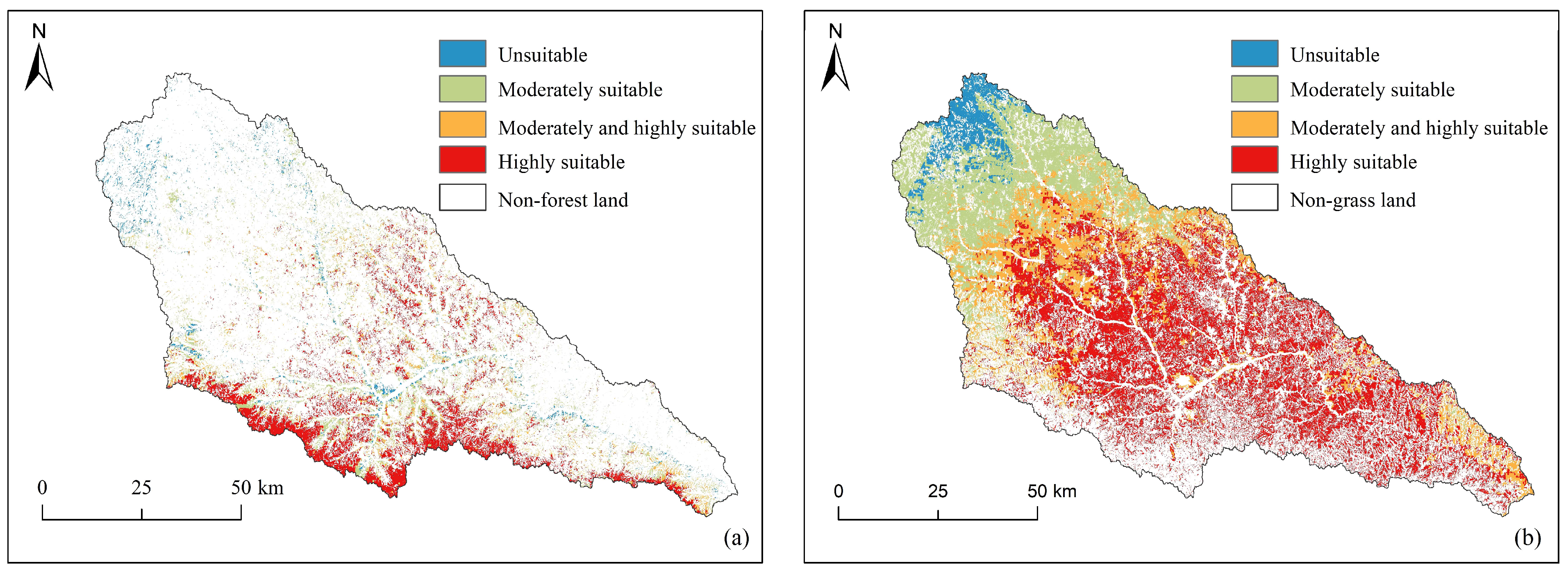
According to the statistical results of forest and grass suitability (
Table 1), the areas with different suitability for forest land, listed from largest to smallest, are as follows: highly suitable, moderately suitable, moderately and highly suitable, and unsuitable (
Table 1). The area ratios are 6.3:2:3.1:1.0. The total area of the basin with moderate suitability and above is 1064.9 km
2, accounting for 91.9% of the total forest land area. This result shows that the spatial layout of forest land in the basin is generally reasonable, providing better habitat conditions for tree growth.
The distribution of forestland suitability in the watershed showed certain spatial differences. Highly suitable forests (
Figure 3a) cluster in the southern and central parts of the basin. The environmental conditions in this area are significantly better than those in other areas. This is mainly manifested in that the PAR component is mostly above 20%, which is conducive to plant photosynthesis; the altitude is mostly 1200–1400 m; the temperature and growing season are relatively suitable; the total phosphorus content in the soil is mostly above 0.12%, which provides the necessary nutrient support for forest growth; the annual precipitation is mostly above 530 mm, which can meet the water demand for forest growth. In addition, these areas have high vegetation coverage, less interference from human activities, and natural habitat conditions suitable for the stable growth of trees.
On the contrary, unsuitable forest lands are mainly clustered in the western part of the basin. The environmental conditions in this area are relatively poor, mainly manifested in the low PAR, generally below 15%; the altitude is mostly above 1400 m; the annual precipitation is insufficient, generally below 470 mm; the lack of water resources restricts the growth of trees. In addition, the soil texture in these areas is poor, the water retention capacity is weak, the soil erosion problem is prominent, and the vegetation coverage is low, which has caused great pressure on the ecological environment. In the future, measures such as artificial grass planting can be used to gradually optimize the land-use type of areas local to grassland or gradually improve their ecological suitability according to the law of natural succession. The moderately and highly suitable areas are mainly distributed in the transitional zone from the southeast to the northwest, with human activities having an impact between the highly suitable areas and the unsuitable areas.
3.2. Grassland Suitability and Spatial Distribution
According to the statistical results of forest and grassland suitability (
Table 1), for grassland, the areas with different suitability, listed from largest to smallest, are as follows: highly suitable, moderately suitable, moderately and highly suitable, and unsuitable (
Table 1). The area ratios are 9.3:4.4:4.1:1.0. The total area of the basin with moderate suitability and above is 4196.9 km
2, accounting for 94.7% of the total grassland area. This result shows that the spatial layout of grassland in the basin is generally reasonable, providing good habitat conditions for the growth of herbaceous plants.
The area distribution of grasslands with different suitability showed obvious spatial differences. Highly suitable forests (
Figure 3a) cluster in the central and eastern parts of the basin (
Figure 3b). The environmental conditions in this area are significantly better than those in other areas, mainly in terms of higher PAR, generally reaching more than 19%, and the light conditions are suitable for the photosynthesis of herbaceous plants; the annual average temperature is mostly above 9.1 °C, and the climate is mild, which is conducive to the growth of herbaceous plants; the altitude is mostly below 1200 m, and the lower altitude and longer growing season provide favorable conditions for herbaceous plants; and the sufficient precipitation, with annual precipitation generally exceeding 530 mm, can meet the water needs of herbaceous plants. In addition, the terrain in these areas is gentle, the problem of soil erosion is relatively light, the vegetation coverage is high, human activities are less disruptive, and the natural habitat conditions are suitable for the stable growth of herbaceous plants.
On the contrary, unsuitable forest lands are mainly clustered in the western part of the basin. The environmental conditions in this area have a significant restrictive effect on the growth of herbaceous plants, mainly manifested in the low PAR component, generally below 13%, and insufficient light conditions, which inhibit the photosynthetic efficiency of plants; the altitude is above 1400 m, and the high altitude leads to low temperatures and a short growing season, which limits the distribution of herbaceous plants; and the precipitation is insufficient, with an annual precipitation level generally less than 490 mm. It belongs to a semi-arid climate, and insufficient water resources restrict the growth of herbaceous plants. The soil texture in some areas is poor, the water retention capacity is weak, the soil erosion problem is prominent, and the vegetation coverage rate is low. In addition, frequent human activities have also put great pressure on the ecological environment. In the future, measures such as artificial grass planting, setting up closed protection areas, and strengthening management and protection can be used to reduce the negative impact of human disturbance and gradually improve the suitability of grasslands. The moderately and highly suitable areas are mainly distributed in the transitional zone from the middle and lower reaches to the upper reaches, with human activities having an impact between the highly suitable areas and the unsuitable areas.
3.3. Potential Assessment of Forest and Grass Quality Improvement
The assessment of forest and grassland quality improvement potential should be based on the mapping relationship between forest/grass suitability and vegetation coverage. When the current vegetation coverage of an evaluation unit is below its threshold level, the unit is considered to have potential for quality improvement through human intervention or natural growth until reaching its vegetation coverage threshold. In evaluating forest and grassland quality improvement potential, Grades I, II, and III, respectively, indicate that the vegetation coverage of an evaluation unit can be upgraded by one, two, or three levels, with Grade I representing the smallest improvement potential, Grade II moderate, and Grade III the greatest. Different suitability levels correspond to distinct improvement potentials (
Table 2). Regarding implementation difficulty within the same suitability zone: Grade I improvements are the easiest to achieve, Grade II moderately challenging, and Grade III the most difficult.
In existing forestlands, the quality improvable areas across suitability zones rank in descending order as high, moderately high, and moderate suitability (
Table 3). The total improvable area spans 366 km
2, accounting for 34.4% of the combined area of these three suitability zones. This demonstrates that after years of conservation management in the Yanhe River Basin, the overall growth status of forests in regions suitable for afforestation (moderate suitability zones and above) remains favorable, with most woodlands having reached coverage thresholds corresponding to their habitat conditions. Notably, the high suitability zone exhibits the largest improvable area and proportion relative to its total zone area, reaching 56.9%, indicating that approximately half of the forested areas in this most suitable region still possess enhancement potential. Regarding the spatial distribution of forest quality improvement potential (
Figure 4a), areas requiring enhancement in the high suitability zone predominantly cluster in the southwestern and southeastern basins. Specifically, Grade I improvement areas are relatively evenly distributed across the entire zone, with two denser clusters in the southwest and southeast. Grades II and III improvements concentrate in the southern basin, where Grade III areas frequently adjoin Grade II zones. In contrast, improvement areas within moderately high and moderate suitability zones display a discrete distribution pattern without significant clustering characteristics.
In existing grasslands, the quality improvable areas across suitability zones rank in descending order as high, moderately high, and moderate suitability (
Table 3). The total improvable area spans 2491.6 km
2, accounting for 59.4% of the combined area of these three suitability zones. This indicates that in regions suitable for grassland restoration (moderate suitability zones and above) within the Yanhe River Basin, the overall growth status of vegetation remains suboptimal, with over half of the areas yet to achieve coverage thresholds corresponding to their habitat conditions. Notably, the high suitability zone contains the largest absolute improvable area, representing approximately three-fifths of the total grassland requiring enhancement. Furthermore, the proportions of improvable areas relative to their respective suitability zones are highest in the high and moderately high suitability zones, reaching 74.7% and 50.9%, respectively. These findings suggest that achieving high and moderately high coverage levels in the basin’s grasslands remains challenging, primarily due to the vegetation’s vulnerability to precipitation variability and anthropogenic disturbances, which hinder natural progression to higher coverage thresholds. Consequently, substantial interventions and supportive measures may be required for grassland quality enhancement. Regarding the spatial distribution of grassland improvement potential (
Figure 4b), Grade I potential areas in the high suitability zone are predominantly located farther from river channels, while Grades II and III cluster closer to these channels. Two dense clusters of Grades II and III occur in the northeastern and central-western basin, with Grade III areas frequently adjacent to Grade II zones. In moderately high suitability zones, Grade I potential areas mainly occupy mid-upper reaches of tributaries or sub-watersheds, whereas Grade II areas concentrate in mid-lower reaches. Improvement potential zones in moderate suitability areas are primarily distributed in the basin’s upper reaches.
Under current land use and vegetation growth conditions in the Yanhe River Basin, significant disparities exist in the quality improvement potential between forests and grasslands. The proportions of quality improvable areas relative to their total respective areas are 31.6% for forests and 56.2% for grasslands, with the grassland ratio being approximately 1.8 times that of forests. This indicates superior growth performance of existing forest compared to grassland, while grassland coverage retains substantial restoration potential. Forest quality improvable areas primarily focus on Grade I potential areas in high suitability zones (
Table 3), where enhancement challenges are relatively minimal. These areas could predominantly employ low-intensity interventions centered on strengthened enclosure management and natural restoration to gradually expand high-coverage forest areas. For grasslands, the main improvable types include Grade I potential areas in highly suitable zones, along with Grade I and Grade II potential areas in moderately high and moderately suitable zones (
Table 3). Given the weaker ecosystem stability and stress resistance of herbaceous vegetation compared to woody plants, improvement complexity escalates with increasing suitability levels. Moderate suitability zones may implement natural restoration through enhanced enclosure management (low-intensity measures). Conversely, high and moderately high suitability zones require integrated high-intensity interventions combining artificial grass planting, enclosure management, and seasonal maintenance. By implementing differentiated intervention intensities across suitability-based potential zones, comprehensive elevation of grassland coverage levels can be systematically achieved.
4. Discussion
A large number of research results [
29,
30,
31] indicate that with the advancement of the Grain for Green project, the vegetation coverage in the region increases, and erosion intensity decreases. However, the negative environmental effects caused by unreasonable human-induced vegetation restoration actions are gradually becoming apparent [
32]. Feng, Shao, et al. have found that irrational vegetation restoration may affect regional hydrological cycles, leading to soil water resource depletion, hindering vegetation growth and development [
33,
34]. For example, large-scale, high-density artificial vegetation restoration can increase soil water consumption, resulting in soil desiccation and even vegetation death [
35,
36]. Therefore, to ensure the sustainability of regional restoration and ecological governance, it is urgent to conduct suitability assessments of the current stage of forestry and grassland in the research area for precise allocation.
Our research findings indicate that elevation, annual precipitation, and soil phosphorus content are key factors influencing the suitability of forest distribution, consistent with previous studies on forest ecosystem dynamics [
37]. These factors together determine the spatial heterogeneity of forest suitability, which has significant implications for sustainable ecosystem management in the region. The significant correlation between elevation and forest suitability aligns with Liu et al. [
7] findings in analogous regions, who identified elevation as a major driver of natural forest distribution. However, our study also highlights that annual precipitation plays a crucial role at lower elevations, suggesting that water availability might be a limiting factor for forest growth in these areas. This difference likely reflects the specific hydrological and climatic conditions of our study area, as well as the potential influence of recent ecological restoration efforts.
The suitability of grassland is primarily influenced by soil water content, annual precipitation, and elevation, echoing Lai Wenhao et al. findings that soil moisture is a critical determinant of herbaceous biomass in semi-arid regions [
9]. This alignment underscores the importance of water resource management in grassland restoration efforts, particularly in areas prone to soil desiccation and vegetation decline. Moreover, our results suggest that moderate precipitation zones (e.g., mid-elevation regions) may be optimal for grassland establishment, given their balanced water availability and temperature conditions. These findings provide some insights for grassland ecological restoration and management. For example, in arid or semi-arid regions, implementing measures to improve soil moisture content may help enhance grassland suitability, thereby increasing the stability and productivity of regional ecosystems. In summary, the results of this study may offer scientific support for landscape management, ecological restoration, land useoptimization, and regional sustainable development.
From the perspective of suitability distribution areas, highly suitable regions are mainly distributed in the southern and central parts of the watershed, with a few areas in the midstream meandering hilly and gully region of the main rivers. Moderately suitable regions are mainly distributed in the central and eastern parts of the watershed, located in the midstream meandering hilly and gully region of the main and tributary rivers, as well as the downstream fragmented original area. These areas are predominantly adjacent to regions with high or moderately high forest suitability. This aligns with on-site field surveys and evaluation data from Yan River sample plots, providing preliminary verification of the assessment methodology’s effectiveness. Compared to conventional qualitative analysis methods such as the Analytic Hierarchy Process (AHP), this study objectively evaluates the suitability of forests and grasslands based on the spatial heterogeneity of evaluation indicators and their spatial explanatory power for characterizing vegetation suitability attributes. The methodology systematically incorporates the spatial heterogeneity relationships between evaluation indicators and outcomes across all stages and components, minimizing bias while delivering a more precise spatial representation of suitability. Additionally, the use of geographical detectors allows for an in-depth exploration of the relationships between vegetation cover and environmental variables, thereby enhancing the robustness of the results [
38]. This method is particularly valuable in complex and heterogeneous regions, such as our study area, where traditional qualitative methods may fail to capture the nuanced dynamics of ecosystem suitability.
Meanwhile, the accuracy of evaluating the suitability of forestry and grassland measures in this method is directly determined by data precision. Due to the limited availability of collectible shared data, as well as issues of data multi-sourcing and inconsistent accuracy, there may be some uncertainty in the precision of the results of this study. Nevertheless, this research employs geodetectors to explore the response relationships between FVC (fraction of vegetation cover) and various environmental indicators, which can, to some extent, reduce this uncertainty. In the future, collecting more on-site measurement data and homogeneous high-precision data will be essential for validating and improving this method.
Although our study emphasizes the role of environmental factors such as topography, climate, and soil in determining the suitability of forests and grasslands, it neglects the substantial influence of anthropogenic activities on ecosystem dynamics, including land-use conversion, agricultural practices, and urbanization. This omission of key human drivers—particularly grazing pressure and urban expansion—may inflate ecological suitability estimates in regions where observed vegetation degradation contradicts environmental potential. The observed grassland degradation in high-suitability zones (
Figure 4b) cannot be fully explained by environmental constraints alone. Emerging research further reveals that rapid urban expansion and agricultural intensification can alter soil quality and hydrological conditions, thereby influencing vegetation suitability outcomes [
39]. Future research should incorporate socioeconomic indicators, such as population density and economic development intensity, to better understand the interplay between human activities and ecosystem sustainability.


 ,
, 