The Interpretation of Historical Layer Evolution Laws in Historic Districts from the Perspective of the Historic Urban Landscape: A Case Study in Shenyang, China
Abstract
1. Introduction
2. Materials and Methods
2.1. Research Framework
2.2. Main Research Methods
2.2.1. Kernel Density Analysis
2.2.2. Geometric Illustration Method
2.3. Research Subjects
3. Results
3.1. Analysis of Laminar Laws in Historical Areas
3.1.1. Single-Core Dominance
3.1.2. Dual-Core Parallelism
3.1.3. Fusion Collage
3.1.4. Extended Extension
3.1.5. Multi-Point Radiation
3.2. Explanation of the Laminar Law of Spatial Patterns
3.3. Analysis of the Law of Lamination of Material Carriers
3.3.1. Point Elements: Large Buildings (Structures) as Anchor Points
- (1)
- Authority buildings
- (2)
- Station
- (3)
- Cultural palace
- (4)
- Religious buildings
- (5)
- Official residences
- (6)
- Production workshop
- (7)
- Landscape structures
- (8)
- Industrial structures
3.3.2. Linear Carriers: Transportation Roads and View Corridors as a Skeleton
- (1)
- Transportation roads
- (2)
- Railroad lines
- (3)
- View corridors
3.3.3. Faceted Carriers: Using Spatial Mechanisms and Patterns as Substrates
- (1)
- Spatial texture
- (2)
- Space pattern
3.4. Analysis of the Law of Layers of Value Characteristics
3.4.1. Law of Centralization
3.4.2. Law of Diversification
3.4.3. Law of Self-Adaptation
3.5. Analysis of Layering Laws in Typical Historic Districts
- (1)
- Fangcheng Historic District
- (2)
- Zhongshan Road Historic District
- (3)
- Tiexi Workers’ Village Historic District
- (4)
- Tangzi Temple Historic District
- (5)
- Refractory Factory Historic District
- (6)
- High-Voltage Switchgear Factory Historic District
- (7)
- Imperial Temple Historic District
- (8)
- Santaizi Workers’ Village Historic District
- (9)
- Zhaoxin Kiln Factory Historic District
- (10)
- Hongmei MSG Factory Historic District
4. Discussion
4.1. From Law to Application: Absolute Protection Combined with Organic Renewal
4.2. Theoretical Paradigm Shift: From Static Conservation to Dynamic Layered Cognition
4.3. Innovation in Protection Mechanisms: Synergistic Governance of Hierarchical Systems and Dynamic Regulation
4.4. Sustainable Regeneration Pathways: Spatial Genetic Continuity and Functional Adaptive Iteration
4.5. Revolutionizing Protection Thinking: Digital Enablement and Dynamic Protection
5. Conclusions
Author Contributions
Funding
Data Availability Statement
Conflicts of Interest
References
- Ginzarly, M.; Houbart, C.; Teller, J. The Historic Urban Landscape approach to urban management: A systematic review. Int. J. Herit. Stud. 2019, 25, 999–1019. [Google Scholar] [CrossRef]
- Bandarin, F.; van Oers, R. The Historic Urban Landscape: Managing Heritage in an Urban Century; John Wiley & Sons: Hoboken, NJ, USA, 2012. [Google Scholar]
- Santander, A.A.; Garai-Olaun, A.A.; De la Fuente Arana, A. Historic urban landscapes: A review on trends and methodologies in the urban context of the 21st century. Sustainability 2018, 10, 2603. [Google Scholar] [CrossRef]
- Taylor, K. The Historic Urban Landscape paradigm and cities as cultural landscapes. Challenging orthodoxy in urban conservation. Landsc. Res. 2016, 41, 471–480. [Google Scholar] [CrossRef]
- Cody, J.; Siravo, F. Historic Cities: Issues in Urban Conservation; Getty Conservation Institute: Los Angeles, CA, USA, 2019. [Google Scholar]
- Xie, S.Y.; Gu, K.; Zhang, X.L. Urban conservation in China in an international context: Retrospect and prospects. Habitat Int. 2020, 95, 102098. [Google Scholar] [CrossRef]
- Bonfantini, G.B. Historic Urbanscapes for Tomorrow, Two Italian Cases:Genoa and Bologna. Eur. Spat. Res. Policy 2015, 22, 57–71. [Google Scholar] [CrossRef]
- Chen, S.J. The Concept of Historic Authenticity and Its Methdology for Preservation of Historic Urban Areas in Chinese Contexts; Univ Pennsylvania Press: Philadelphia, PA, USA, 2014. [Google Scholar]
- Fan, L. International influence and local response: Understanding community involvement in urban heritage conservation in China. Int. J. Herit. Stud. 2014, 20, 651–662. [Google Scholar] [CrossRef]
- Geppert, A. Planning systems facing heritage issues in Europe: From protection to management, in the plural interpretations of the values of the past. Eur. Spat. Res. Policy 2015, 22, 5–8. [Google Scholar]
- Jiang, J.; Zhou, T.; Han, Y.; Ikebe, K. Urban heritage conservation and modern urban development from the perspective of the historic urban landscape approach: A case study of Suzhou. Land 2022, 11, 1251. [Google Scholar] [CrossRef]
- Aysegul, K.T. Method for assessment of the historical urban landscape. Procedia Eng. 2016, 161, 1697–1703. [Google Scholar] [CrossRef]
- Pereira Roders, A. The historic urban landscape approach in action: Eight years later. In Reshaping Urban Conservation: The Historic Urban Landscape Approach in Action; Springer: Berlin/Heidelberg, Germany, 2019; pp. 21–54. [Google Scholar]
- Zancheti, S.M.; Loretto, R.P. Dynamic integrity: A concept to historic urban landscape. J. Cult. Herit. Manag. Sustain. Dev. 2015, 5, 82–94. [Google Scholar] [CrossRef]
- Zeayter, H.; Mansour, A.M.H. Heritage conservation ideologies analysis–Historic urban Landscape approach for a Mediterranean historic city case study. HBRC J. 2018, 14, 345–356. [Google Scholar] [CrossRef]
- Whitehand, J. Urban morphology and historic urban landscapes. World Herit. Pap. 2010, 27, 35–44. [Google Scholar]
- Grazuleviciute-Vileniske, I.; Seduikyte, L.; Daugelaite, A.; Rudokas, K. Links between heritage building, historic urban landscape and sustainable development: Systematic approach. Landsc. Archit. Art 2020, 17, 30–38. [Google Scholar] [CrossRef]
- Turner, M.; Singer, R. Researching and mapping the historic urban landscape. In Reconnecting the City: The Historic Urban Landscape Approach and the Future of Urban Heritage; Wiley-Blackwell: Hoboken, NJ, USA, 2014; pp. 301–315. [Google Scholar]
- Liu, T.H.; Butler, R.J.; Zhang, C.Y. Evaluation of public perceptions of authenticity of urban heritage under the conservation paradigm of Historic Urban Landscape: A case study of the Five Avenues Historic District in Tianjing, China. J. Archit. Conserv. 2019, 25, 228–251. [Google Scholar] [CrossRef]
- Prabowo, B.N.; Pramesti, P.U.; Ramandhika, M.; Sukawi, S. Historic urban landscape (HUL) approach in Kota Lama Semarang: Mapping the layer of physical development through the chronological history. IOP Conf. Ser. Earth Environ. Sci. 2020, 1, 402. [Google Scholar] [CrossRef]
- Jiang, J.; Zang, T.; Xing, J.; Ikebe, K. Spatial distribution of urban heritage and landscape approach to urban contextual continuity: The case of Suzhou. Land 2023, 12, 150. [Google Scholar] [CrossRef]
- Li, X.X.; Ye, Z. Urban Morphology and Historical Urban Landscape Conservation and Management. In Conserving and Managing Historical Urban Landscape: An Integrated Morphological Approach; Springer: Singapore, 2023; pp. 7–32. [Google Scholar]
- Lynch, K. The Image of the City; MIT Press: Cambridge, MA, USA, 1964. [Google Scholar]
- Qi, K. Morphology of the City; Southeast University Press: Nanjing, China, 2001. [Google Scholar]
- Liu, Y.F. The Anchoring-Layering Theory: For a Better Understanding and Conservation of Historic Urban Landscape. Ph.D. Thesis, Tsinghua University, Beijing, China, 2014. [Google Scholar]
- Ding, S.S. A Study in the Construction of a City’s Historical and Culture Landscape Network, Based on the Patch-Corridor Theory: Take Traditional-Landscape-Clustered Area in Hangzhou’s Old Town as an Example; D. Theory; Zhejiang University: Zhejiang, China, 2012. [Google Scholar]
- Li, H.P.; Yang, N. Study on the Overall Protection Framework of Historic Towns in Southwest Moutainous Area in the Perspective of Historic Urban Landscape. Urban Dev. Stud. 2018, 25, 66–73. [Google Scholar]
- Fu, S.G.; Shen, B.J. Study on the “Folding” Method of Historic Urban Landscapes: A Case of the Historic Urban Landscape of Tanggong Market in Luoyang. Urban. Archit. 2023, 20, 146–149. [Google Scholar]
- Xiao, J.; Cao, K. Characteristic Extraction and Layering Interpretation of Historic Urban Landscape in Ü-Tsang. Chin. Landsc. Archit. 2019, 35, 101–106. [Google Scholar]
- Cai, R. Study on Adaptation Protection for Historic Blocks from the Perspective of Layering Rules Analysis: A Case Study of Ciqikou Historic Block, Chongqing; Chongqing University: Chongqing, China, 2020. [Google Scholar]
- Pei, Y.; Yang, R.; Dang, A.R. Historic Layering Process Interpretation and Value Assessment of the Ancient City of Yulin Based on Historic Urban Landscape Approach. Urban Dev. Stud. 2022, 29, 128–136. [Google Scholar]
- Feng, C.Z.Y. Layering, Characteristic and Inheritance:The Exploration on the Protectionand Renewal Strategy of Kuixingxiang Block in Yuncheng. Chin. Overseas Archit. 2023, 09, 61–68. [Google Scholar]
- Xiao, J.; Cao, K.; Li, H.P. The Evolution Laws and Layering Management Methodologies of Historic Urban Landscape. Urban Dev. Stud. 2018, 25, 59–69. [Google Scholar]
- Xiao, J.; Li, H.P.; Cao, K. The Regional Features and Layering Processes of Historical Urban Landscape in Lhasa. Archit. J. 2017, 9, 58–63. [Google Scholar]
- Kuitert, W. Urban landscape systems understood by geo-history map overlay. J. Landsc. Archit. 2013, 8, 54–63. [Google Scholar] [CrossRef]
- Cai, R.Z.; Nasu, S. Adopting the ‘historic layering’ concept from the Historic Urban Landscape approach as a methodological framework for urban heritage conservation. Int. J. Herit. Stud. 2025, 31, 573–591. [Google Scholar] [CrossRef]
- Bushmakina, Y.V.; Balyberdina, P.A.; Dmitrieva, M.K.; Gogoleva, M.V. The use of GIS for studying cultural heritage and historical urban landscape: The case of Perm and Usolie (Russia). Ge-Conservacion 2017, 11, 26. [Google Scholar]
- Tian, H.; Han, Z.; Xu, W.; Liu, X.; Qiu, W.; Li, W. Evolution of historical urban landscape with computer vision and machine learning: A case study of Berlin. J. Digit. Landsc. Archit 2021, 6, 436–451. [Google Scholar]
- Wang, Y.; Jin, C.; Xu, D.; Wang, T.; Wang, B. Analysis of Multi-Dimensional Layers in Historic Districts Based on Theory of the Historic Urban Landscape: Taking Shenyang Fangcheng as an Example. Land 2024, 13, 1736. [Google Scholar] [CrossRef]
- Pang, S.J.; Li, N.H.; Lin, Y.Q.; Zhao, X. The Revealing of “Layers”: The Thoughts on the Preparation of Urban Design Guidelines for Windscape Control of Streets Along the Central Axis in Beijing. Beijing Plan. Rev. 2019, 1, 44–50. [Google Scholar]
- Yang, J. Study on the Characteristic Recognition and Layered Cognition of Historic Urban Landscape in Nanjing. J. Hum. Settl. West China 2023, 38, 117–124. [Google Scholar]
- Bai, X.; Jiao, X.; Sakai, T.; Xu, H. Mapping the past with historical geographic information systems: Layered characteristics of the historic urban landscape of Nanjingg, China, since the Ming Dynasty (1368–2024). Herit. Sci. 2024, 12, 283. [Google Scholar] [CrossRef]
- Wu, C.H.; Li, G.P.; Li, Y.T.; Pu, Y.; Zhang, Y.Z. A Review of Research on Strategies and Methods for the Revitalization of Urban Historic Districts. In IOP Conference Series: Earth and Environmental Science; IOP Publishing: Bristol, UK, 2022; Volume 5, p. 1101. [Google Scholar]
- Choi, S.; Walter, R.J.; Chalana, M. Walter, and Manish Chalana. Untangling our checkered past: Investigating the link between local historic district designation and spatial segregation history. Cities 2025, 158, 105621. [Google Scholar] [CrossRef]
- Vignali, E.B. Historic Districts: Preserving the Old with the Compatible New. William Mary Law Rev. 2017, 59, 345. [Google Scholar]
- Yung, E.H.K.; Chan, E.H.W.; Xu, Y. Sustainable development and the rehabilitation of a historic urban district–Social sustainability in the case of Tianzifang in Shanghai. Sustain. Dev. 2014, 22, 95–112. [Google Scholar] [CrossRef]
- Zhou, T.; Zhou, Y.L.; Liu, G.W. Comparison of critical success paths for historic district renovation and redevelopment projects in China. Habitat Int. 2017, 67, 54–68. [Google Scholar] [CrossRef]
- Zhang, H.; Wang, F.; Guo, F.; Cai, J.; Dong, J. Urban built heritage protection and realistic dilemmas: The development process, protection system, and critical thinking of historic districts in Dalian. Built Herit. 2023, 7, 25. [Google Scholar] [CrossRef]
- Zhang, M.; Zhang, Y.; Fang, X.; Wang, X. A 3D spatial diagnostic framework of sustainable historic and cultural district preservation: A case study in Henan, China. Buildings 2023, 13, 1344. [Google Scholar] [CrossRef]
- Yang, X.; Shen, J. Integrating historic landscape characterization for historic district assessment through multi-source data: A case study from Hangzhou, China. npj Herit. Sci. 2025, 13, 33. [Google Scholar] [CrossRef]
- Pankakoski, T. From historical structures to temporal layers: Hans Freyer and conceptual history. Hist. Theory 2020, 59, 61–91. [Google Scholar] [CrossRef]
- Schulz-Forberg, H. The Spatial and Temporal Layers of Global History: A Reflection on Global Conceptual History through Expanding Reinhart Koselleck’s “Zeitschichten” into Global Spaces. Hist. Soc. Res. 2013, 38, 40–58. [Google Scholar]
- Weiss, L.M. Informal Settlements and Urban Heritage Landscapes in South Africa. J. Soc. Archaeol. 2014, 14, 3–25. [Google Scholar] [CrossRef]
- Ebejer, J. Values as a base for the viable adaptive reuse of fortified heritage in urban contexts. Muzeológia A Kultúrne dedičstvo 2019, 11, 41–72. [Google Scholar] [CrossRef]
- Wang, S.; Zhang, J.; Wang, F.; Dong, Y. How to achieve a balance between functional improvement and heritage conservation? A case study on the renewal of old Beijing city. Sustain. Cities Soc. 2023, 98, 104790. [Google Scholar] [CrossRef]
- Wang, H.J.; Zeng, Z.T. A multi-objective decision-making process for reuse selection of historic buildings. Expert Syst. Appl. 2010, 37, 1241–1249. [Google Scholar] [CrossRef]
- Camatti, N.; di Tollo, G.; Gastaldi, F.; Camerin, F. Cultural heritage reuse applying fuzzy expert knowledge and machine learning: Venice’s fortresses case study. Reg. Stud. Reg. Sci. 2025, 12, 225–251. [Google Scholar] [CrossRef]
- Yau, Y. Multi-criteria decision making for urban built heritage conservation: Application of the analytic hierarchy process. J. Build. Apprais. 2009, 4, 191–205. [Google Scholar] [CrossRef]
- Pinero, I.; San-Jose, J.T.; Rodriguez, P.; Losanez, M.M. Multi-criteria decision-making for grading the rehabilitation of heritage sites. Application in the historic center of La Habana. J. Cult. Herit. 2017, 26, 144–152. [Google Scholar] [CrossRef]
- Andria, J.; di Tollo, G.; Pesenti, R. A heuristic fuzzy algorithm for assessing and managing tourism sustainability. Soft Comput. 2020, 24, 4027–4040. [Google Scholar] [CrossRef]

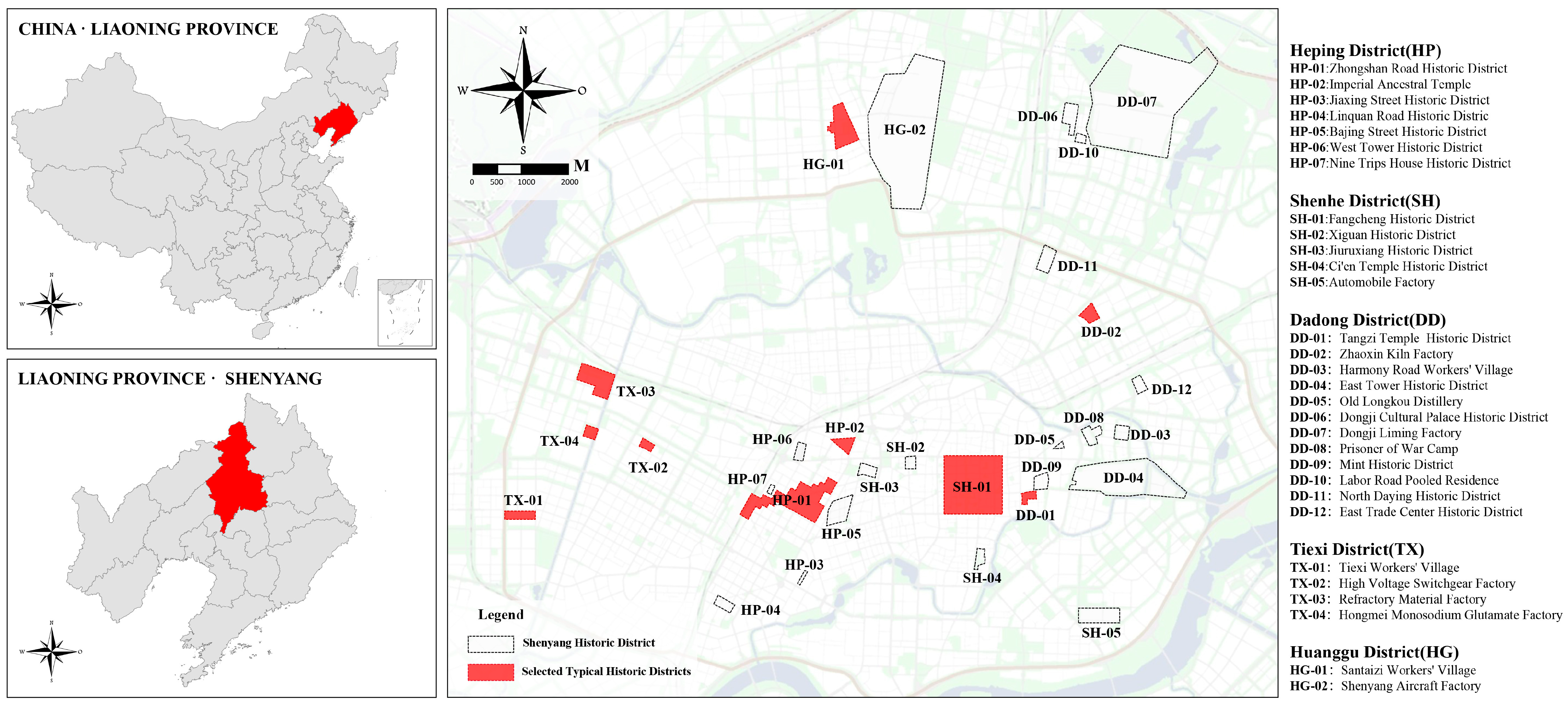
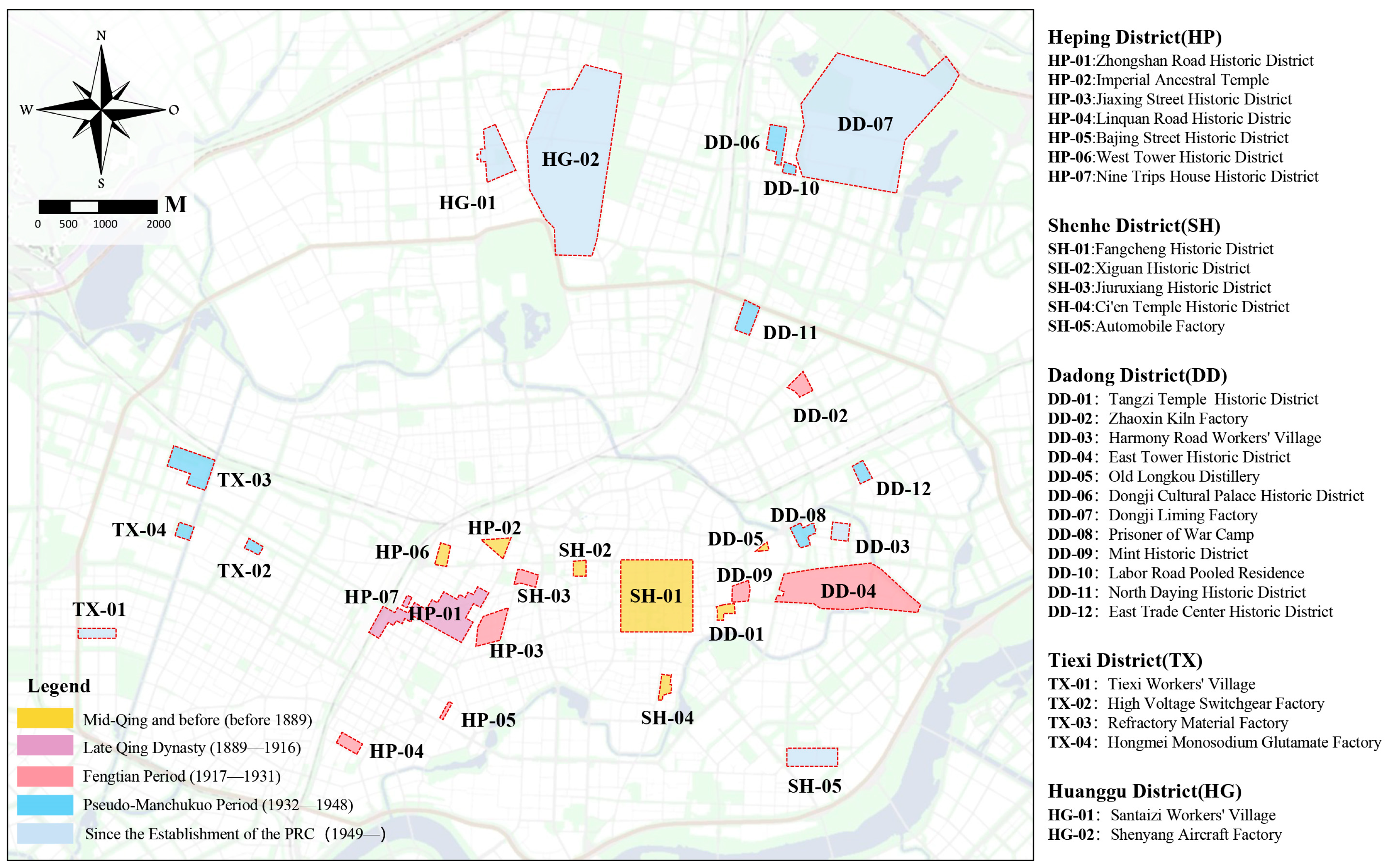


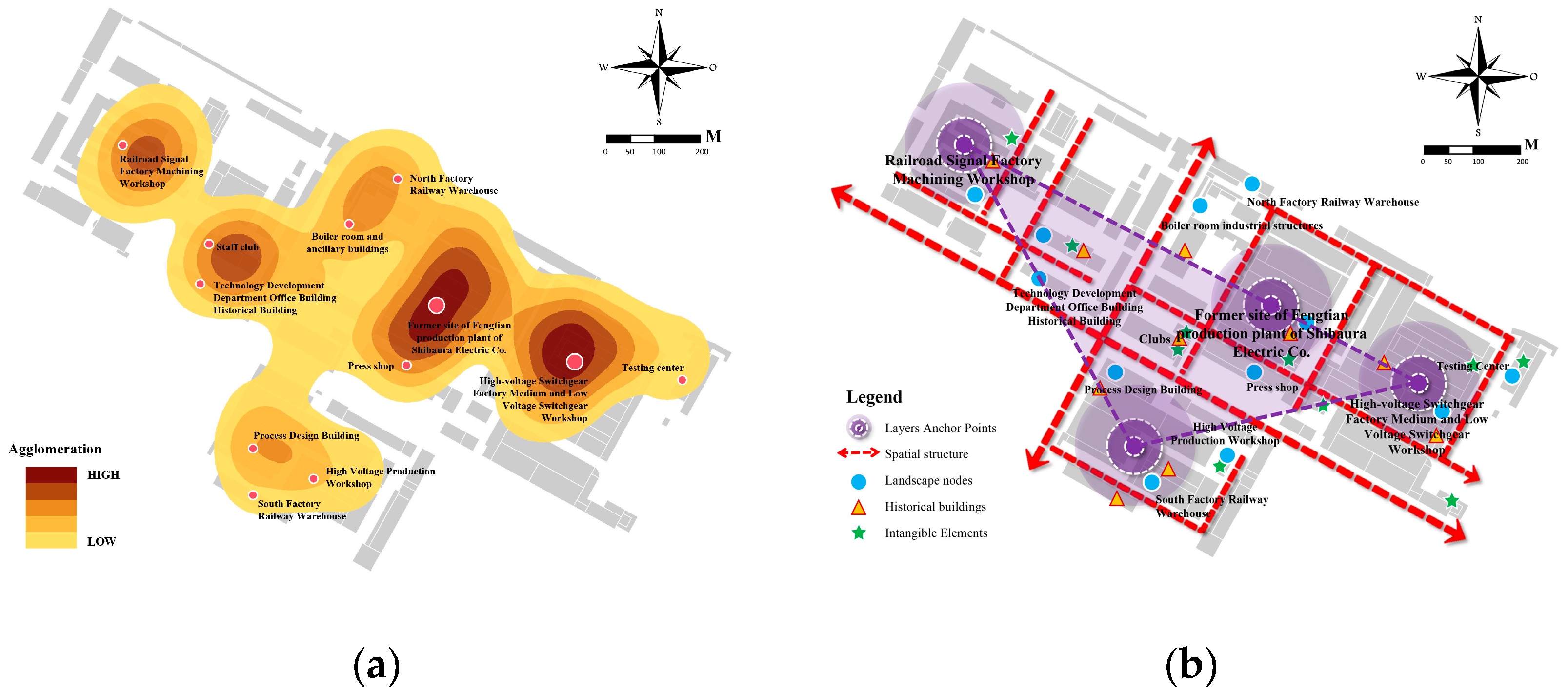


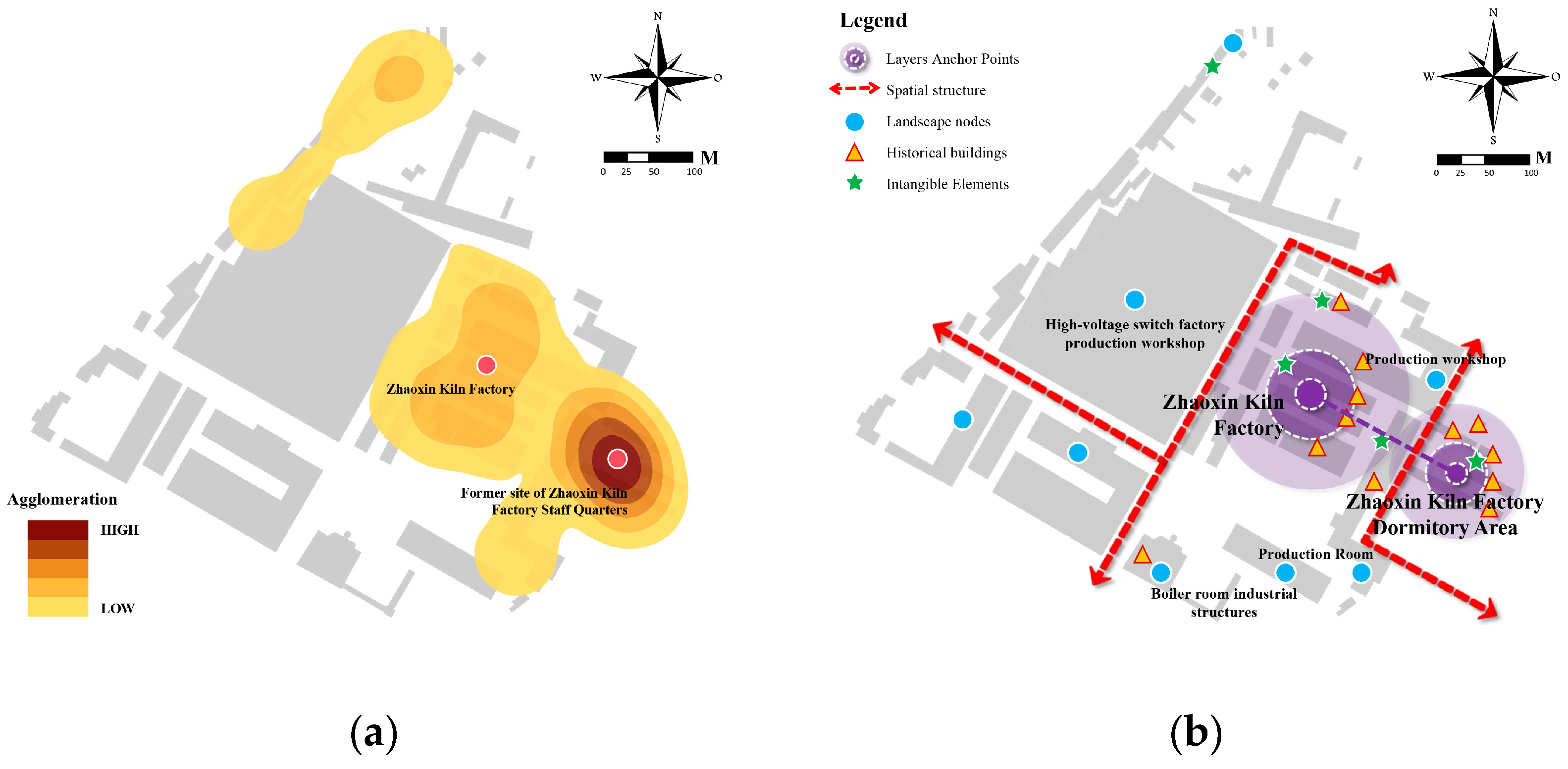

| No. | Name | Location | Categorization | Causality | ||
|---|---|---|---|---|---|---|
| Function | Period | Protection Stage | ||||
| 1 | Fangcheng Historic District | Shenhe district | Administrative function-led | Ancient | Updating | Historical and cultural district |
| 2 | Zhongshan Road Historic District | Heping district | Administrative function-led | Capitalist times | Updating | Historical and cultural district |
| 3 | Tiexi Workers’ Village | Tiexi district | Residential function-led | Modernity | Updating | Historical and cultural district |
| 4 | High-Voltage Switchgear Factory | Tiexi district | Industrial heritage-led | Capitalist times | Updating | Industrial heritage historic sites |
| 5 | Refractory Material Factory | Tiexi district | Industrial heritage-led | Capitalist times | Updating | Industrial heritage historic sites |
| 6 | Tangzi Street Historic District | Dadong district | Hybrid functional | Ancient | Updating | Historical area |
| 7 | Zhaoxin Kiln Factory | Dadong district | Industrial heritage-led | Capitalist times | Not updated | Industrial heritage historic sites |
| 8 | Santaizi Workers’ Village | Huanggu district | Residential function-led | Modernity | Updating | Industrial heritage historic sites |
| 9 | Imperial Ancestral Temple | Heping district | Cultural function-led | Ancient | Updated | Historical area |
| 10 | Jiaxing Street Historic District | Heping district | Residential function-led | Capitalist times | Updating | Historical area |
| 11 | Linquan Road Historic District | Heping district | Residential function-led | Capitalist times | Updating | Historical area |
| 12 | Bajing Street Historic District | Heping district | Hybrid functional | Capitalist times | Updating | Historical area |
| 13 | Xiguan Historic District | Shenhe district | Cultural function-led | Ancient | Not updated | Historic style district |
| 14 | Jiuruxiang Historic District | Shenhe district | Residential function-led | Capitalist times | Not updated | Historical area |
| 15 | Ci’en Temple Historic District | Shenhe district | Cultural function-led | Ancient | Updating | Historical area |
| 16 | Harmony Road Workers’ Village | Dadong district | Residential function-led | Modernity | Not updated | Industrial heritage historic sites |
| 17 | East Tower Historic District | Dadong district | Industrial heritage-led | Ancient | Updating | Historic style district |
| 18 | Old Longkou Winery | Dadong district | Industrial heritage-led | Ancient | Updating | Industrial heritage historic sites |
| 19 | Automobile Factory | Shenhe district | Industrial heritage-led | Modernity | Not updated | Industrial heritage historic areas |
| 20 | Shenyang Aircraft Factory | Huanggu district | Industrial heritage-led | Capitalist times | Not updated | Industrial heritage historic areas |
| 21 | Dongji Cultural Palace | Dadong district | Hybrid functional | Capitalist times | Not updated | Industrial heritage historic areas |
| 22 | Dongji Factory | Dadong district | Industrial heritage-led | Capitalist times | Not updated | Industrial heritage historic areas |
| 23 | Prisoner of War Camp Historic District | Dadong district | Industrial heritage-led | Capitalist times | Updated | Industrial heritage historic areas |
| 24 | Mint Historic District | Dadong district | Industrial heritage-led | Ancient | Not updated | Industrial heritage historic areas |
| 25 | Hongmei Monosodium Glutamate Factory | Tiexi district | Industrial heritage-led | Capitalist times | Updated | Industrial heritage historic areas |
| 26 | West Tower Historic District | Heping district | Cultural function-led | Ancient | Updating | Historic style district |
| 27 | Nine Trips House Historic District | Heping district | Residential function-led | Capitalist times | Not updated | Historic style district |
| 28 | Labor Road Historic District | Dadong district | Residential function-led | Capitalist times | Not updated | Historic style district |
| 29 | North Daying Historic District | Dadong district | Hybrid functional | Capitalist times | Updating | Historic style district |
| 30 | East Trade Center Historic District | Dadong district | Industrial heritage-led | Capitalist times | Updated | Industrial heritage historic areas |
| Typology | Interpretation | Characteristic | Illustration |
|---|---|---|---|
| Radial | Radial refers to a cascading pattern of spatial organization and functional areas expanding radially outward from a center. The center of this pattern typically functions as a node of historical or functional importance, such as an administrative center, a religious site, or a market. | (1) Central node: usually the earliest building or functional area in the historic district, of high heritage value. (2) Radial road network: taking the center as the starting point and extending in all directions, connecting the surrounding functional areas and building clusters. (3) Level-by-level expansion: space and functions gradually accumulate from the core area to the outer layer, and the layer-by-layer effect gradually diminishes. |  |
| Toroidal | The toroidal type is characterized by the district’s concentric layered structure, wherein the outer ring typically delineates the district’s boundaries, surrounding important nodes or areas, and reflecting the trajectory of the city’s development and expansion in the form of multiple ring layers. | (1) Continuous boundary: the ring element is usually the boundary zone of the historic district, regular and continuous, reacting to the functional areas within. (2) Layer-by-layer expansion: each layer of the ring represents the expansion and functional change of the district over time. (3) Transportation and functional radiation: The transportation system and functional areas are dispersed from the outside to the inside, forming multiple concentric rings. | 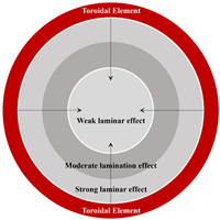 |
| Trigonom-etry | The concept of triangular layering pertains to the spatial configuration and allocation of functional zones within the historic district, with numerous anchoring points serving as the nucleus. This configuration gives rise to a stable triangular spatial configuration, characterized by interactions and interconnections between the anchoring points. | (1) Multiple anchor points: usually important historical buildings, public facilities, or transportation hubs, forming key nodes in the space. (2)Triangular layout: the connection between different anchor points forms a triangular division of functional areas and a transportation network. (3) Complementarity between anchors: different functional areas are distributed around the anchors and are interconnected to build a layered structure of the district. |  |
| Multilateral | A polygonal type is defined as a form of the district that exhibits a complex polygonal structure, which is typically formed as a result of a combination of multiple significant nodes and complex topographic and functional demands. | (1) Irregular boundaries: irregular polygonal spatial organization due to the presence of multiple anchor points or topographic constraints. (2) Polycentric structure: multiple core areas may exist, resulting in a polygonal development in the distribution of the district’s historic space. (3) Interlocking functional blocks: different functional areas are interlaced and distributed in the polygonal structure, forming a complex spatial layering. |  |
| Linear | The term “linear” is employed to denote the spatial layering pattern of development in a historic district along a linear axis. This development is typically closely associated with natural geographic features (e.g., rivers), transportation routes (e.g., railroads, roads), and visual corridors. | (1) Distribution along a line: the functions and buildings of a district are distributed along a major axis with a tendency to expand linearly. (2) Types of axes: axes may be historically important transportation routes, view corridors, or natural geographic boundaries. (3) Functional tandem: different functional areas along a linear axis are connected through transportation relationships. | 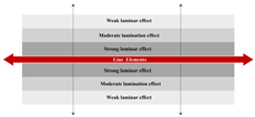 |
| Lattice -type | The concept of grid-type layer law refers to the spatial organization of the historic district, which exhibits a regular or semi-regular grid-like layout, reflecting the principles of socialist construction and accentuating a sense of order and solemnity. | (1) Regular street network: the district presents a square network of roads and streets, with buildings and functional areas distributed in the grid. (2) Balanced functional distribution: functional areas are evenly distributed in the grid, forming an orderly district structure. (3) Adaptation to functional needs: the grid layout may be slightly adjusted according to functional and topographical needs, but it remains largely regular. | 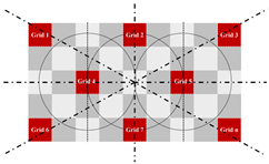 |
| Plaque -type | The spatial organization and functional distribution within the historic district exist in the form of irregular patches, reflecting construction activities, urban development, functional zoning, and environmental constraints of different historical periods. | (1) Irregular distribution: functional areas or historical stratification in the district show patchy distribution with obvious boundaries. (2) Interlocking and overlapping: different functional areas interlock or overlap with each other spatially, forming a complex layered relationship. (3) Independence and interaction: patches independently form a functional area, but there are interactions and connections between them. |  |
Disclaimer/Publisher’s Note: The statements, opinions and data contained in all publications are solely those of the individual author(s) and contributor(s) and not of MDPI and/or the editor(s). MDPI and/or the editor(s) disclaim responsibility for any injury to people or property resulting from any ideas, methods, instructions or products referred to in the content. |
© 2025 by the authors. Licensee MDPI, Basel, Switzerland. This article is an open access article distributed under the terms and conditions of the Creative Commons Attribution (CC BY) license (https://creativecommons.org/licenses/by/4.0/).
Share and Cite
Wang, Y.; Jin, C.; Wang, T.; Xu, D. The Interpretation of Historical Layer Evolution Laws in Historic Districts from the Perspective of the Historic Urban Landscape: A Case Study in Shenyang, China. Land 2025, 14, 1029. https://doi.org/10.3390/land14051029
Wang Y, Jin C, Wang T, Xu D. The Interpretation of Historical Layer Evolution Laws in Historic Districts from the Perspective of the Historic Urban Landscape: A Case Study in Shenyang, China. Land. 2025; 14(5):1029. https://doi.org/10.3390/land14051029
Chicago/Turabian StyleWang, Yuan, Chengxie Jin, Tiebo Wang, and Danyang Xu. 2025. "The Interpretation of Historical Layer Evolution Laws in Historic Districts from the Perspective of the Historic Urban Landscape: A Case Study in Shenyang, China" Land 14, no. 5: 1029. https://doi.org/10.3390/land14051029
APA StyleWang, Y., Jin, C., Wang, T., & Xu, D. (2025). The Interpretation of Historical Layer Evolution Laws in Historic Districts from the Perspective of the Historic Urban Landscape: A Case Study in Shenyang, China. Land, 14(5), 1029. https://doi.org/10.3390/land14051029


