Article

The Background of the Gioconda: Geomorphological and Historical Data from the Montefeltro Area (Tuscan–Emilian Apennines, Central Italy)

1
Interdepartmental Research Centre “Urbino e la Prospettiva”, University of Urbino, 61029 Urbino, PU, Italy
2
Department of Pure and Applied Sciences, University of Urbino, 61029 Urbino, PU, Italy
3
Department of Biomolecular Sciences, University of Urbino, 61029 Urbino, PU, Italy
*
Author to whom correspondence should be addressed.
Land 2025, 14(5), 1007; https://doi.org/10.3390/land14051007
Submission received: 28 March 2025 / Revised: 24 April 2025 / Accepted: 30 April 2025 / Published: 6 May 2025

Abstract

:
This work combines geomorphological and historical research to decode the landscape in the world’s most famous painting: the Gioconda. The background of the painting was analysed in detail, and numerous morphological correspondences with the Montefeltro area in Central Italy were found. The upper valley of the Senatello stream features the Fumaiolo Massif, renowned for its springs that feed the River Tiber. The region is composed of the limestones and sandstones of the San Marino and Monte Fumaiolo Formations, alongside clay formations from the “Valmarecchia Nappe”. This lithological variety, the intense fracturing of the limestone rocks, and climatic and tectonic events during the Middle to Upper Pleistocene produced a complex and varied geomorphology. The landscape is marked by large landslides and significant debris deposits, reflecting its recent evolution. The painting, as well as historical documents and Leonardo’s drawings from his time in the Romagna region, provide evidence of a large lake beneath Mount Aquilone. The area was affected by a significant change in the morphology of the slopes, probably caused by a landslide that occurred in the period 1500–1700, a period characterised by climatic and tectonic upheavals, which may have led to the disappearance of the lake.

1. Introduction

Many Italian masterpieces contain carefully painted landscapes that might go unnoticed behind the main subjects in the foreground. Art historians have often considered these landscapes imaginary, although many appear to be views of Central Italy, where the Renaissance flourished. The northernmost part of Montefeltro, on the border with Tuscany, among the spectacular limestone crags of the Valmarecchia, was immortalised by Leonardo da Vinci in the background of his masterpiece: the Gioconda [1].
Leonardo knew this area well, having been there several times, as testified by many documents. When Leonardo came to Montefeltro following the Borgia army, his job of supervising the fortifications and military structures led him to visit the entire territory. For almost ten months, he surveyed the hills of the central Apennines, between Montefeltro and the Romagna region, up to the highest peaks where numerous watchtowers were placed. From these peaks, Leonardo probably began to appreciate the unique and extraordinary landscape of the Marecchia Valley. It is no coincidence that many of Leonardo’s drawings faithfully refer to these areas [1]. While accompanying Cesare Borgia, Leonardo recorded his movements between 1498 and 1502 in Manuscript L, which is preserved in Paris. His itinerary also included Urbino, where he measured the walls and made sketches of the Ducal Palace. During his stay, which lasted about forty days, he stayed in a tower house managed by the monks of San Francesco [2]. Previous research, documented by recent articles and essays, has identified the landscape depicted in this painting, as well as other Renaissance works [1,2,3], based mainly on geological and geomorphological data but supported by numerous historical and archival sources.
The present work, through an interdisciplinary methodological approach, offers a further contribution to the resolution of the enigmatic and articulate landscape that forms the backdrop to the Gioconda, focusing on that part, perhaps the most complex of the background, represented by the lake located to the upper right, at the foot of what has been recognised as the Fumaiolo Massif.

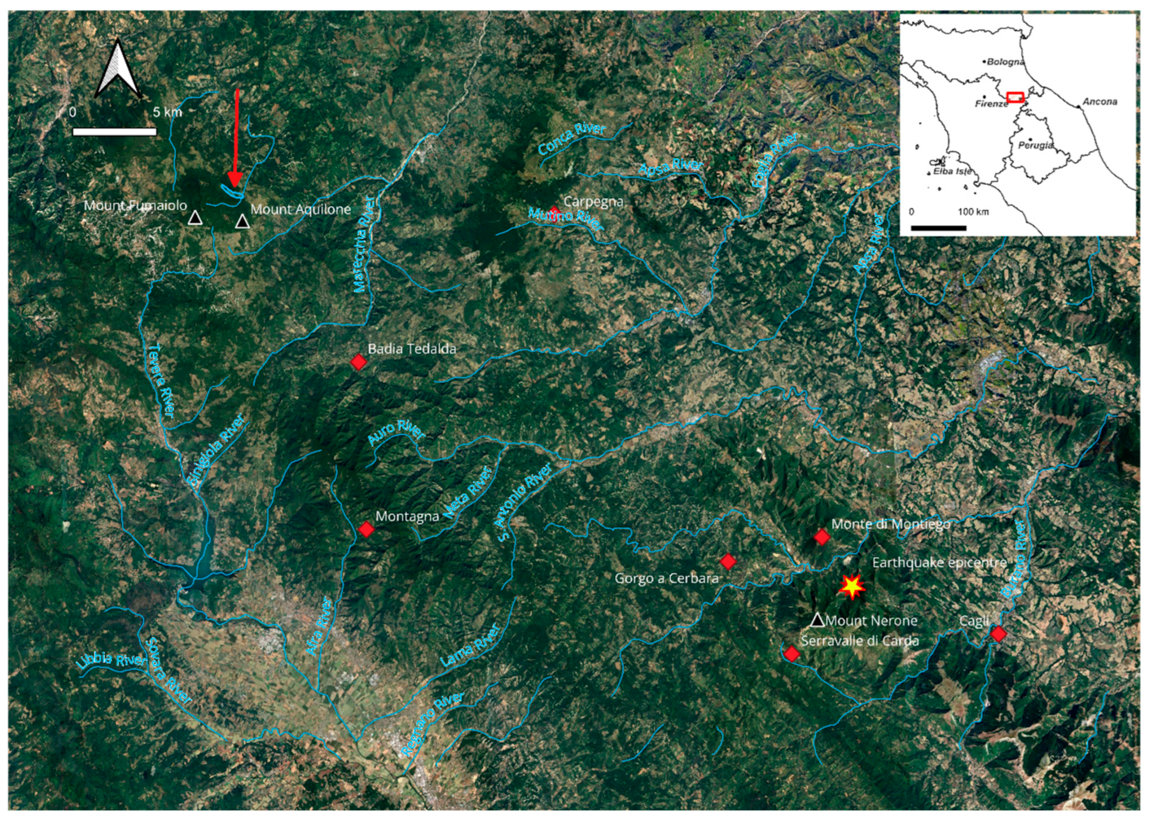
2. Geomorphological Setting of the Area

The landscape of the Apennines, straddling the regions of Umbria, Marche, Tuscany, and Emilia-Romagna, i.e., the ancient territory of Montefeltro and the Duchy of Urbino (Figure 1), is made up of a great variety of forms resulting from different physical environments [4]. These environments sometimes gradually merge, while at other times, they abruptly diverge, creating strong morphological contrasts. This diversity of forms is undoubtedly fascinating for its intrinsic beauty and the history and culture developed around it. Therefore, it is unsurprising that such landscapes have inspired the sensitivity of the artists who, especially during the Renaissance, travelled through these lands. The study of the territory—shaped and transformed by geological, climate, and anthropic events—constitutes the basis for understanding its artistic representation in a given historical period. The geological and tectonic context of this particular sector of the Apennines has left an unmistakable imprint on the landscape. This territory’s uniqueness derives from the variety of lithologies present and their reciprocal structural relationships. The nature and evolution of the submarine environments that have succeeded one another during the long geological history of this area can be read in the Umbro-Marchean Succession, a continuous series of strata that “records” an almost uninterrupted period from the Jurassic period (about 201 million years ago) to the Pleistocene (about 2.5 to 0.01 million years ago). The Umbro-Marchean Succession is one of the most studied stratigraphic series worldwide due to its completeness and continuity. Several authors demonstrate the complexity of the evolution of the Northern Apennines, with adjacent zones showing abrupt variations in their history and style of deformation [5,6,7,8,9,10,11]. The Marche region began to acquire its current geomorphological structure from the second half of the Miocene, approximately between 13 and 5 million years ago, with the formation of the Apennine chain and the beginning of the emersion of the area [12,13].
The uplift leading to the emergence progressed from southwest to northeast, toward the Adriatic Sea, through an intense folding of the earth’s crust, characterised by the formation of large folds variously associated with significant faults. The westernmost portion of the present chain rose first under the action of tectonic forces (the Umbrian–Marchean ridge, comprising the Catria, Petrano, and Nerone Mountains), followed by the easternmost sectors (the Marchean ridge, including the Furlo Mountains) and smaller ridges (the Cesana Mountains) [14].
The tectonic deformation was more intense in the inland areas, resulting in a more significant uplift, consequent deeper valley incisions, and the shaping of rugged landscapes with strong morphological contrasts. The increasingly gentle uplift toward the valleys and coastal areas, combined with less resistant rock formations, led to a hilly morphology extending down to the sea, only locally interrupted by small ridges. A large part of the western territory (the upper valleys of the Metauro, Foglia, and Marecchia Rivers) is instead characterised by the monotonous sequence of strata belonging to the Marnoso–Arenacea Formation of the Miocene age (about 20 million years ago). The marine basin facing the emerging Apennine chain began to fill with terrigenous sediments, remobilised by submarine landslides, sometimes triggered by seismic events, powerful waves, or currents.
The lithostratigraphic and structural arrangement has conditioned the layout of the river network; it has an overall sub-parallel pattern, mainly oriented southwest–northeast, from the interior towards the Adriatic coast, and it crosses prominent calcareous anticlinal ridges before reaching the Adriatic coast [14]. The formed landscapes are profoundly influenced by alternating different lithological types, thicknesses, and structural arrangements. A distinctive morphology characterises the northwestern portion of the territory, the so-called Montefeltro area: steep isolated reliefs and large limestone blocks chaotically emerge from a soft clay substrate (Figure 2). Here, the formation of the Apennine chain caused geological formations originating in the Tyrrhenian areas (Liguria and Tuscany) to overlap in extensive thrust sheets on top of the local Umbrian–Marchean Succession [15,16,17]. The strong lithological contrast between the Ligurian substratum, predominantly clayey and plastic, and the more rigid Epiligurian “rafts” (limestone, gypsum, conglomerates, and sandstones) has contributed to shaping a highly distinctive landscape, unique in the Apennine region (Figure 3).
The result of this singular evolution, which lasted about 12 million years, is the current Montefeltro landscape. The reliefs, subjected to intense tectonic and climatic stress, were fractured and reduced in size due to repeated landslide events. Often, only remnants of the primary morphology remain in the form of scattered blocks, spires, or towers on the clayey slopes. The highest peaks are Mount Aquilone (Fumaiolo Massif) and Mount Carpegna, respectively, at 1354 and 1415 m a.s.l.. The shape of the numerous isolated reliefs depends on the orientation of stratification, as seen in the Sassi Simone and Simoncello, as well as the Maioletto, Penna, and Billi cliffs [18].
The current configuration of the territory, with the arrangement of river valleys descending sub-parallel from the Apennine watershed toward the Adriatic Sea, emerged in relatively recent times, around 700,000 years ago, during the Middle Pleistocene [13]. During this period, the area underwent significant climatic changes: the landscape was shaped by erosion and sedimentation processes alternating between glacial and subtropical climates. In particular, erosive activity on the reliefs and sediment accumulation in the valley floors peaked during cold phases, when physical weathering processes were more intense due to reduced or even absent vegetation cover. During these periods, extensive floodplains formed, appearing today as remnants along river corridors. These are the alluvial terraces, evidence of the extent and power of fluvial sedimentation [19].
Warm and cold periods also alternated during the Holocene, although they did not reach the duration and intensity of the previous Pleistocene events. Nevertheless, they also left an imprint on the landscape, slopes, and river plains, leading to significant geomorphological changes, such as erosional scarps, fluvial sediment deposits, large landslides, and the formation of badlands [20,21].
The period corresponding to Leonardo’s life, between 1452 and 1519, falls within the so-called Little Ice Age (LIA, 1300–1850) [22]. During this period, the Alpine ice caps expanded significantly in Europe and Italy, with significant advancement phases occurring between 1360–1390, 1600–1670, and 1820–1860 (Figure 4). However, in the years when Leonardo lived, there was a brief warming phase. In fact, during this period, the Alpine glaciers temporarily retreated to more backward positions, signalling a warmer interval [23]. The last cold phase (1820–1860) led to the maximum glacial expansion of the Holocene, which caused some of the most recent changes in the landscape, still clearly visible today. In particular, it is believed that the massive alluvial deposition in riverbeds, still recognisable in aerial photographs from the 1950s-1960s, resulted from that cold peak, which triggered an intense deforestation on mountain slopes, increasing the production of debris and the formation of landslides. It is difficult to establish the extent to which man has been responsible for landscape changes in relation to climatic episodes. Since Roman times, riverbed changes have been found, diverted, and interrupted to create reservoirs and crossings or to reclaim land for agriculture. Deforestation could also have an anthropogenic cause, as intensive and continuous logging for warming purposes was particularly prevalent during colder periods [24]. Over the past sixty years, the morphogenetic impact of human activity on the landscape has become devastating. With the advent of industrialisation, the indiscriminate use of land through urban sprawl, concrete development, and gravel extraction has severely compromised an immense landscape and cultural heritage.

3. Materials and Methods

Among the various disciplines involved in the methodological framework, geomorphology provides a fundamental contribution to the identification and interpretation of natural features. The systematic analysis of the factors responsible for the shaping and modification of the land surface—including geological evolution, climatic variability, and anthropogenic influence—forms the basis for understanding the landscape as represented in artistic depictions.
During the Renaissance period, numerous artists developed a new conception of landscape painting, grounded not only in aesthetic representation but also in a conscious analysis of the environment. These artists demonstrated exceptional observational skills and a profound naturalistic sensitivity, enabling them to reproduce landforms with remarkable accuracy, intuitively recognising fundamental geomorphological processes such as erosion, sediment transport, and deposition [2]. Given that portrait painters, in particular, often depicted background landscapes with remarkable fidelity—effectively functioning as historical “snapshots” and frequently guided by the specific requests of their patrons—such artworks can be considered as primary historical sources documenting the ancient morphology of the territories associated with the figures depicted [1,3].
The methodological approach to the survey and reconstruction of landscapes is primarily based on advanced image analysis techniques, applied both to the painted representations and to the current physical landscape. Digital image processing enables a detailed investigation of chromatic and morphological features, enhancing detail recognition and allowing the extraction of geomorphological indicators from the artworks. The resulting landforms and topographic profiles are compared with contemporary terrain data to identify morphological changes that have occurred over time.
The use of Digital Elevation Models (DEMs) further supports the analysis by providing three-dimensional visualisations of the terrain from multiple perspectives and elevations, enabling the accurate determination of the viewpoints adopted by artists. The exclusion of vegetative and anthropogenic elements in DEMs facilitates the clearer identification of primary landforms. Field-based geomorphological surveys, supplemented by aerial, drone, and satellite imagery analyses, in combination with paleoclimatic reconstructions and geoarchaeological investigations, contribute to a comprehensive understanding of the landscape’s evolution.
In some cases, geomorphological features such as landslides, lakes, or floodplains may be absent in historical artworks but present in the current landscape, reflecting significant climatic events or anthropogenic interventions. The back-analysis process, crucial to this approach, aims to reconstruct the diachronic evolution of the same landscape by identifying processes such as slope instability and fluvial erosion, which can cause substantial morphological transformations, especially during extreme events [2,3].
Furthermore, variations in vegetation cover, recognised as key morphodynamic factors, are systematically incorporated into the analysis, given their critical role in mediating erosion, sedimentation, and slope stability over time.
Finally, the application of a multidisciplinary framework—integrating historical research on the development of the territory, artists’ biographies, archival studies on patrons, and ecological and environmental data—is essential to achieve a scientifically rigorous reconstruction and interpretation of past landscapes.

4. Results

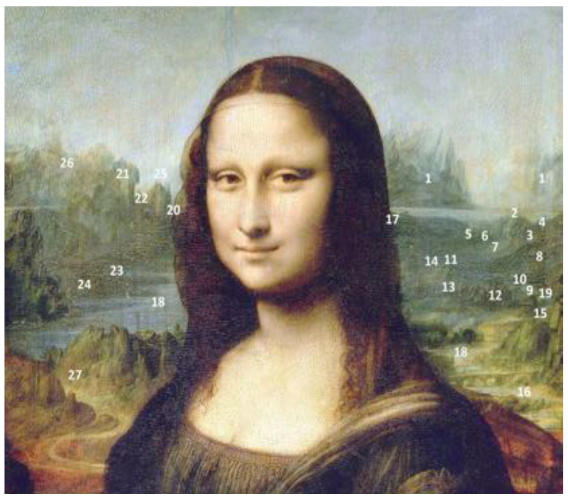
4.1. The Identity of La Gioconda

Contrary to what many believe, some authors have argued that the Gioconda does not depict Lisa Gherardini, wife of the Florentine merchant Francesco del Giocondo, but Pacifica Brandani of Urbino, mistress of Giuliano de’ Medici and mother of his only son [25,26].
Zapperi demonstrates in detail and with abundant documentation that the child, after being secretly entrusted to a family during his early years, was brought to Rome in 1513 by order of Leo X, Giuliano’s brother and the newly elected pope, who received him with affection [26]. Leo X commissioned the famous Raphael to paint the child next to him in a celebrated painting (Figure 5). The young Ippolito missed his mother, and in response, Giuliano asked Leonardo, who was in his employ, to create a portrait of a woman to comfort him, making Ippolito believe it was his mother. After Giuliano’s sudden death, Leonardo took the portrait to France. Convincing evidence supporting Pacifica Brandani as the subject of La Gioconda is provided by Don Antonio De Beatis, secretary to Cardinal Luigi d’Aragona, who travelled across Europe in 1517–1518 [27]. During their stay in France, they visited Leonardo, who was a guest of King Francis I, at his residence in Amboise. De Beatis meticulously recorded what Leonardo revealed, namely that the Gioconda had been commissioned by his patron, Giuliano de’ Medici. In 1957, Leonardo expert Carlo Pedretti suggested that the Gioconda might instead be Pacifica Brandani, with whom Giuliano de’ Medici had a relationship in Urbino and who bore him a son, Ippolito, in 1511. Leonardo is believed to have painted her while working for Giuliano between 1514 and 1516, shortly before his departure for France. Over time, Pacifica’s identity faded into obscurity, and in the 17th century, she was associated with the name “Mona Lisa” through Vasari’s legend.
Perrig argues that in Renaissance paintings, the landscape in the background of a portrait always has a relationship with the subject portrayed in the foreground [28]. The identification of La Gioconda as Pacifica Brandani supports this hypothesis. If we consider that the lady was indeed Pacifica Brandani of Urbino, that the patron of the work was Giuliano de’ Medici, and that Ippolito was their son, we can deduce that the chosen landscape could only represent a land significant to all three: the Duchies of Urbino and Tuscany. The bridge over the Marecchia River is precisely on the border between the Duchies of Urbino and Tuscany. It is possible that Ippolito, the son, symbolises the union between Pacifica and Giuliano and, thus, between the two states.

4.2. The Gioconda Landscape

Leonardo dedicated much of his life to the study of nature. The geological and paleontological studies carried out near his place of birth, Vinci (Italy), are notable, as well as the detailed geological and sedimentological structures represented in his paintings [29]. He often made maps of the places he visited for study purposes and for his patrons. We remember the geographical maps of Tuscany and the map of the city of Imola (Northern Italy), a work of art for its precision and detail [30]. Many drawings are also catalogued as “unknown landscapes” that have never been precisely identified because they lack toponyms. However, these drawings have unmistakable geomorphological features that allow for their exact location, considering changes related to climatic, tectonic, and anthropogenic changes.
An accurate analysis of the painting and profound knowledge of the territory has allowed the identification of the many details that compose the landscape of the Gioconda, which embraces the entire Duchy of Urbino, seen from the heights of the Marecchia Valley [1]. Leonardo’s technique for representing the territory relies on aerial vision to depict vast areas through the compression and distortion of spaces and distances, creating a representation that straddles the line between the image of a landscape and a topographic map [31].
The background of the Gioconda embraces a wide area, starting from the Tuscany region in the upper valley of the Marecchia River with its tributary, the Senatello stream. It is a broad view and is seen from high above to enable a view of almost 270° in an uninterrupted landscape. There are two viewpoints: from the top of Mount Benedetto on the left of the Gioconda and Mount Carpegna on the right (Figure 6). Leonardo solves his need for a broad view by placing together objects that should be placed at different optical distances. In fact, being high enough to see mountain massifs makes it challenging to see a bridge or a valley road. Leonardo had already adopted different scales in some of his drawings, as was common practice in the topographic descriptions of that period [30].
The central image of the Gioconda interrupts but does not hide parts of the landscape. The shapes depicted have a precise spatial position and can be easily compared with the actual forms, even if some have been modified by tectonic or climatic events since 1500. Many physical and anthropic elements such as towns, castles, towers, and mills have been recognised (Figure 7) [1]; the only elements that no longer exist are the bridge across the Marecchia River (Figure 8), and the lake under Mount Aquilone (Figure 9), on the right side of the painting. In the following sections, several sectors of the Gioconda painting are presented and compared to the mid-Marecchia Valley and Senatello basin: the bridge near Pennabilli village and the midway Senatello Valley (sector A); the left side of the painting (sector B); and the upper right sector, perhaps the most complex, represented by the lake at the foot of the Fumaiolo Massif (sector C). The main objective of this work is to clarify certain aspects, providing key elements to understand their morphological evolution, using historical data, maps, seismic data, and field data, to reconstruct a landscape that in almost 600 years may have changed in its geomorphological aspects, due to tectonic and climatic factors.

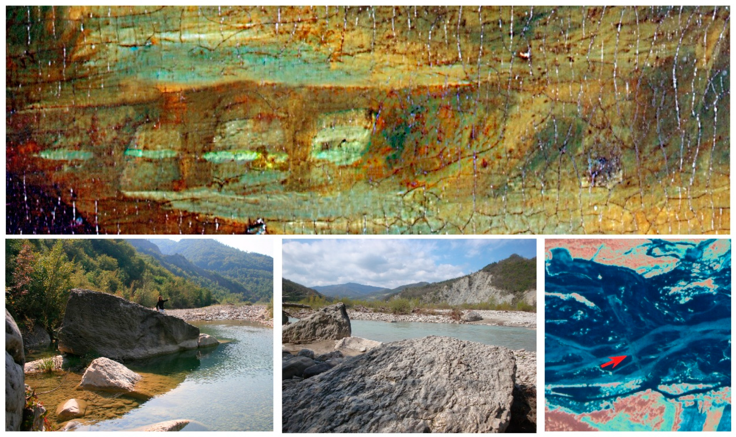
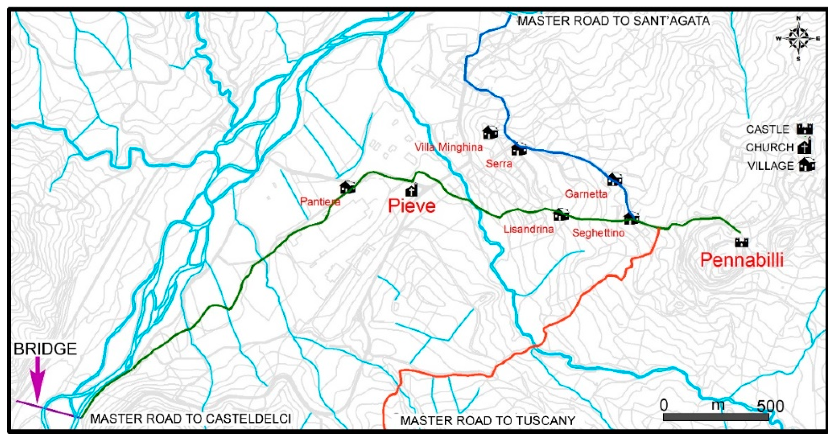
4.2.1. Sector A: The Bridge near Pennabilli Village and the Midway Senatello Valley

The large water course in sector A is the Marecchia River (Figure 10). Its source is located at Alpe della Luna, in the Tuscan–Romagna Apennines, and after 70 km, it flows into the Adriatic Sea near the town of Rimini. The floodplain, which today flows with densely braided channels on a wide and flat alluvial valley floor, has changed shape over time according to the climatic and tectonic conditions that have affected the area and due to massive anthropic interventions. The four-arch bridge rests on large boulders and is located slightly downstream from the confluence of the Senatello and Marecchia Rivers. In the painting, the bridge appears to be severely damaged (see Figure 8). The large limestone boulders emerging from the alluvial deposits, completely unrelated to the surrounding formations, are the so-called “migrating boulders” formed during the last glaciation from the slopes of Mount Canale and that reached the plane where they were permanently rooted [32]. They were finally used as the supporting structure of the bridge.
A study on the ancient road system carried out by the Department of Archaeology of the University of Urbino showed that a road crossed the river at that point (Figure 11) [33]. It is an ancient, destroyed road that, in Roman times, connected the Vicus Ad Missam to the Vicus in the San Martino di Casteldelci area. In Medieval times, the road continued and connected the castle of Pennabilli and its church of San Pietro in Messa to the castle of Casteldelci and its church of San Martino, both located beyond the Marecchia River in the Casteldelci area. Remains of brick artefacts have been found in the area, presumably belonging to a bridge. There is documentation of bridges destroyed by floods, and even today, aerial photographs show a crossing at that location.
As a result of selective erosion, the Penna and Billi hills rise above the surrounding countryside, close to the Marecchia River (Figure 12). The Digital Elevation Model also highlights the exact position of the rocks seen from the easternmost foothills of Mount Carpegna.
Near the village of Casteldelci, in the midway the Senatello Valley, the Marnoso–Arenacea Formation is exposed, revealing a regular alternation of layers that imparts an orderly aspect to the region, complemented by rectilinear parallel profiles and deep asymmetrical valleys. The dip-slope layers contribute to the characteristic flatiron morphology, which is vividly illustrated in Leonardo da Vinci’s drawings (Figure 13). Midway along its course, the Senatello Torrent accumulates a significant volume of debris, creating a large alluvial plain that features distinctly intertwined channels up to its confluence with the Marecchia River. A comprehensive overview of the entire area elucidates the spatial relationships between the elements of the artwork and the contemporary landscape (Figure 14).

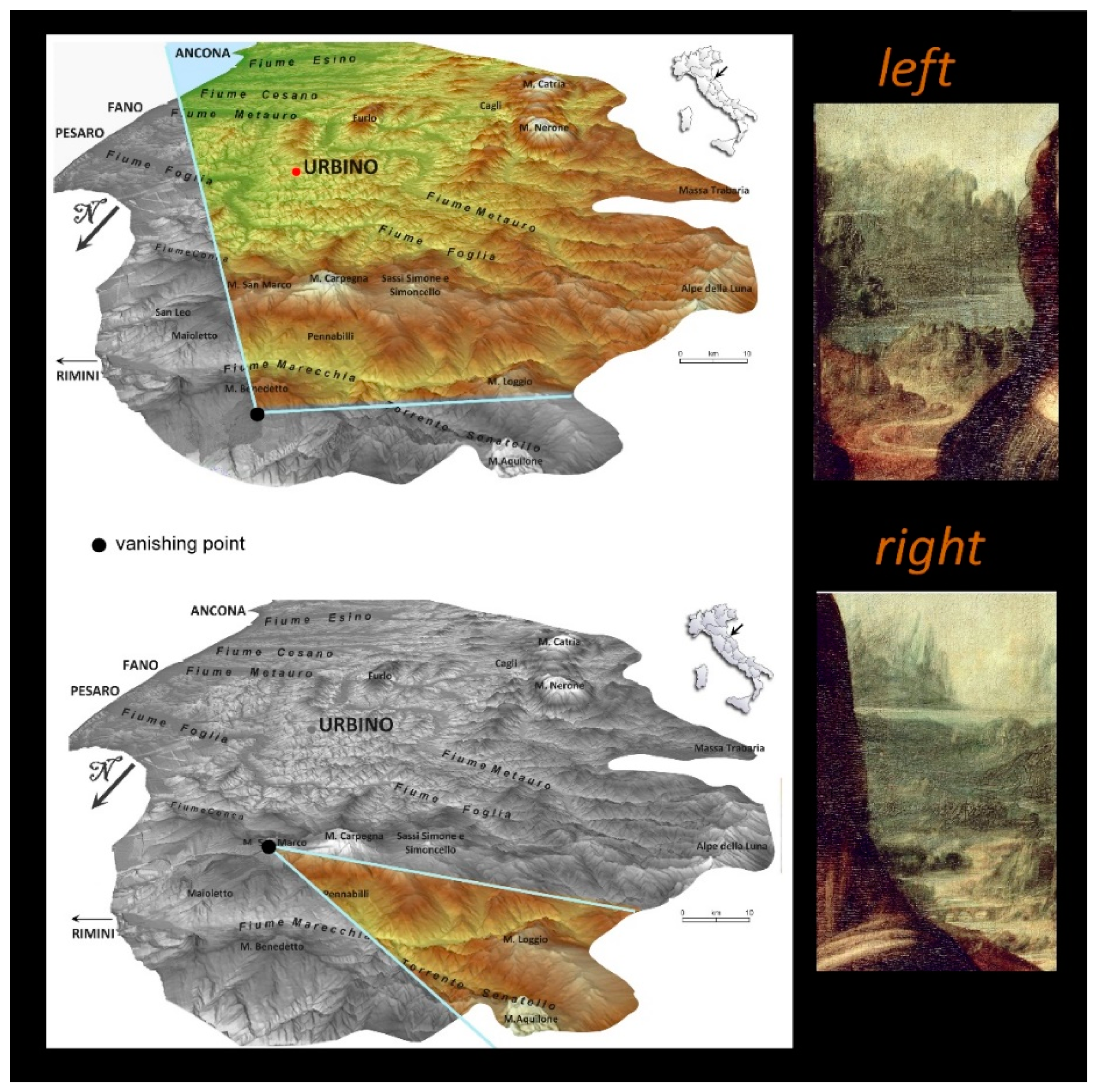
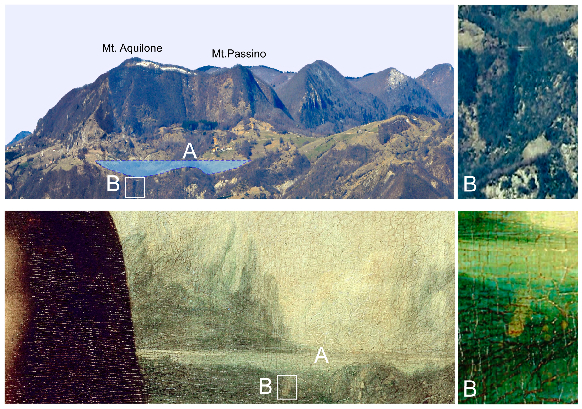
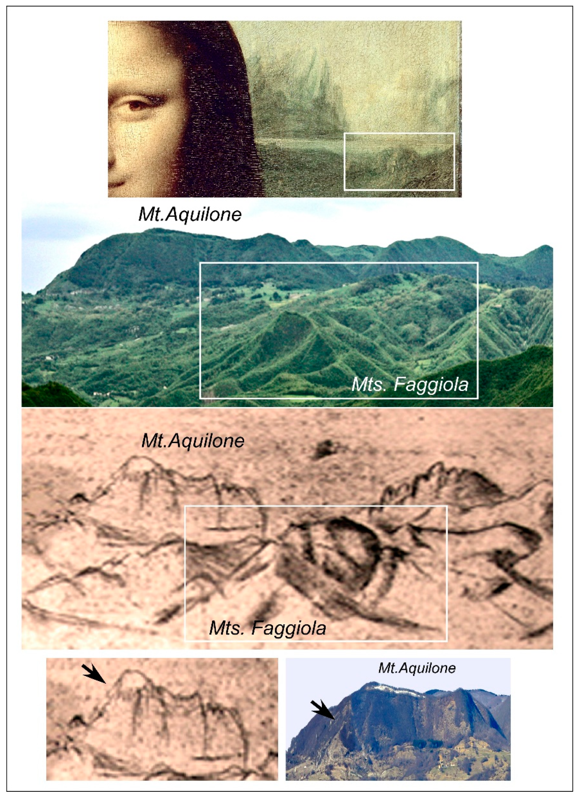
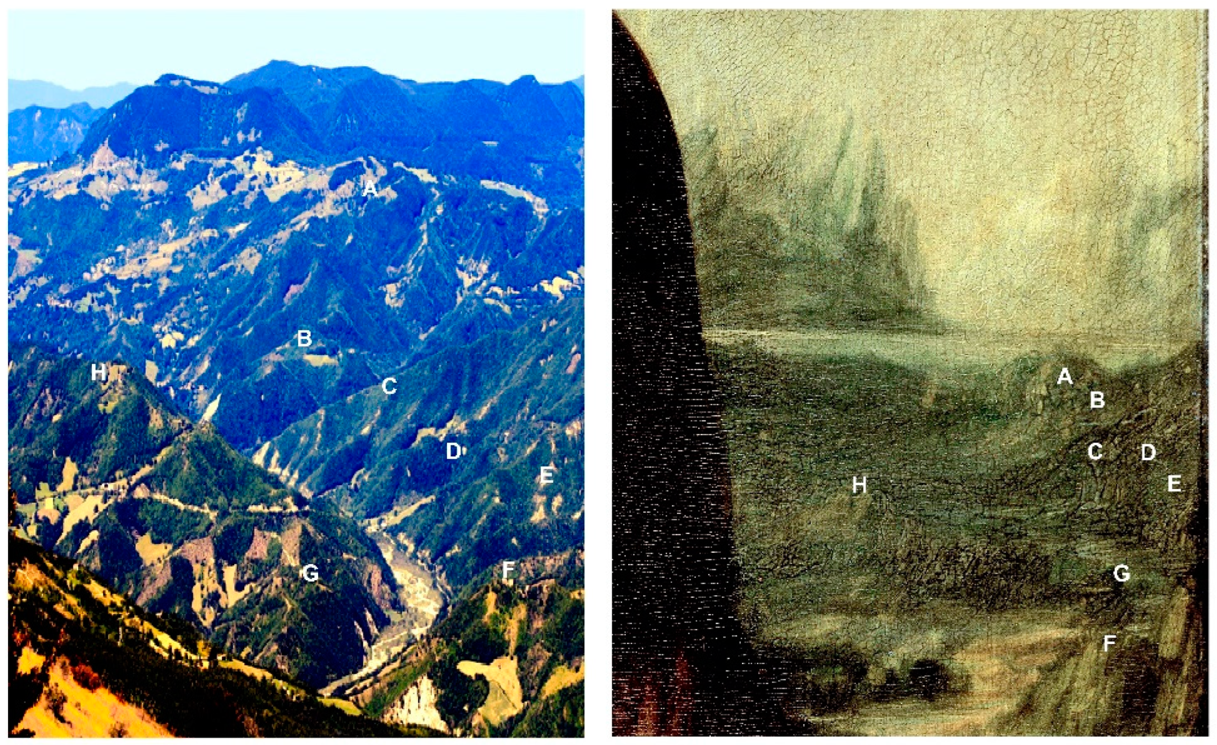
4.2.2. Sector B: The Left Side of the Painting

The landscape depicted on the left side of the painting is one of the most complex to interpret, because Leonardo experiments in this area with an advanced and revolutionary representation of relief, separating the perspectival planes not only by colour but also by compressing and distorting them in the form of anamorphosis, to enhance the sense of relief and depth. This representation serves as an intermediary between a landscape drawing from life and a topographic map, synthesising the perception of perspectival space and measuring distances [30]. Starting from the horizon, the Umbro-Marchean Apennine chain is depicted, extending from the Alpe della Luna to Mount Catria (Figure 1) [34]. The broad plain visible further down in the painting corresponds to the Marecchia River, whose slopes are characterised by narrow asymmetric valleys due to monoclinal stratifications and landslide phenomena. Further downstream, the extreme spur of Mount Canale is visible, with its distinctive round shape. The relief is dotted with limestone boulders that presumably originated from the summit, where extensive plates existed during the Pleistocene era, now wholly dismantled. In the foreground on the left side of the painting, Leonardo positions two cliffs named Sassi Simone and Simoncello (Figure 15), representing one of the most visited geosites in the Montefeltro area [35]. Numerous maps and drawings exist of this area, because Cosimo de’ Medici founded a new town on the flat top of Sasso Simone, which he called “Città del Sole”. This town survived for only a century and was abandoned because of harsh conditions during the LIA [36].

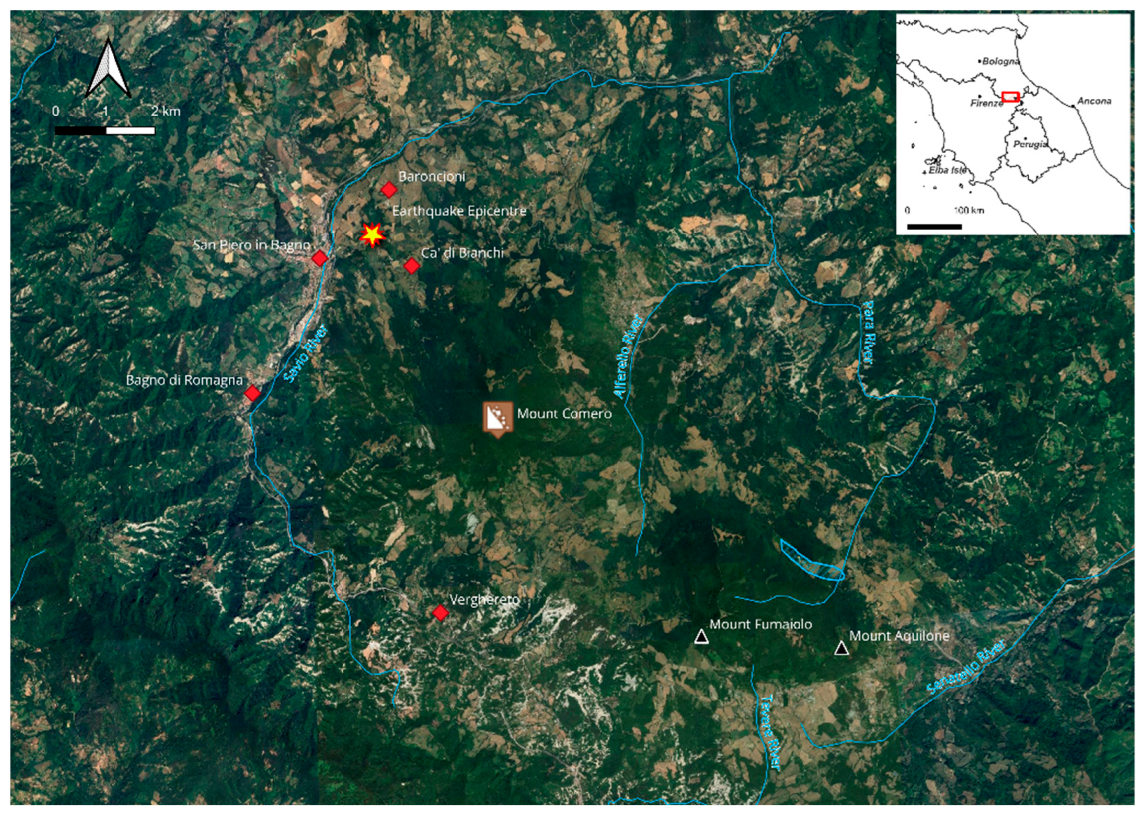
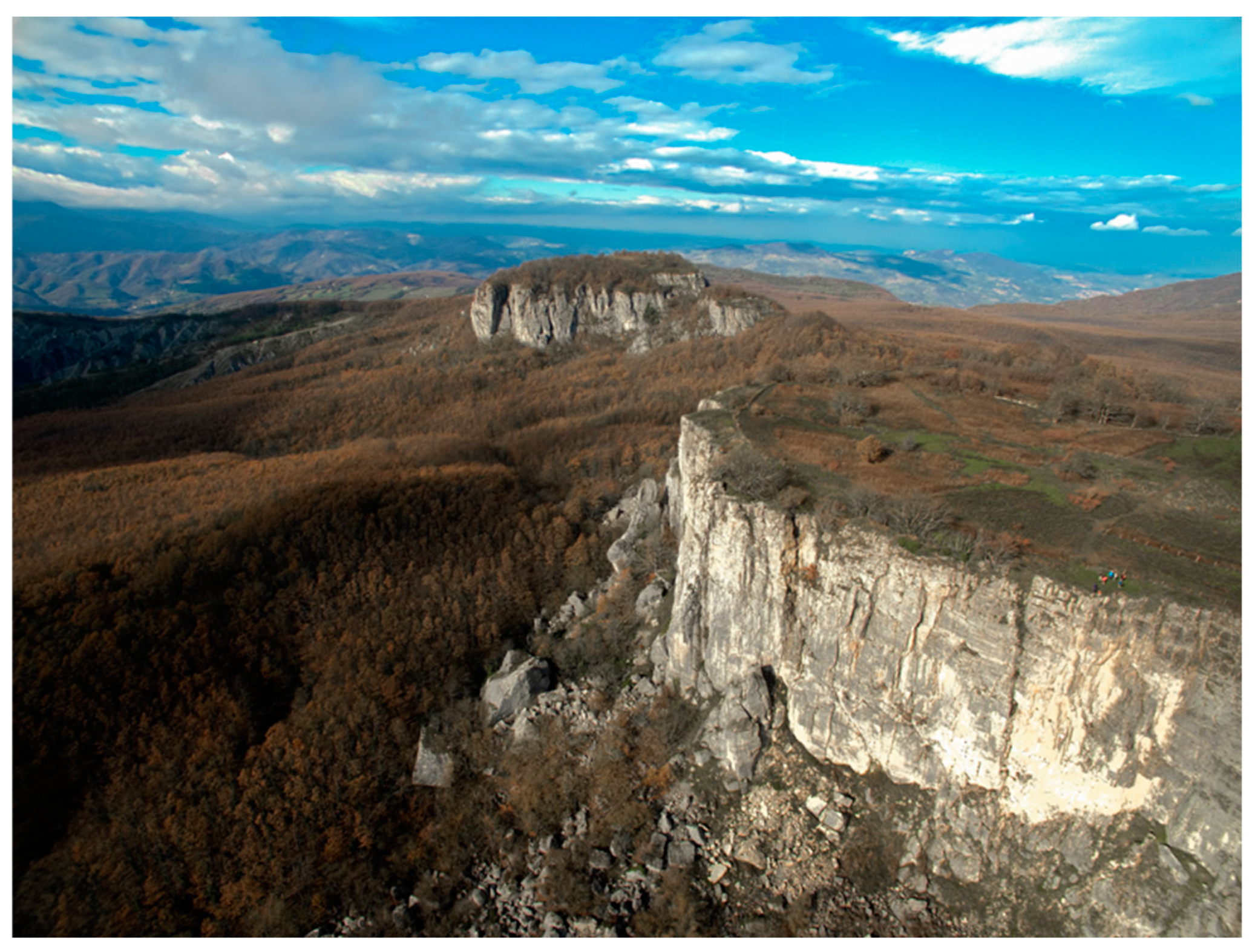
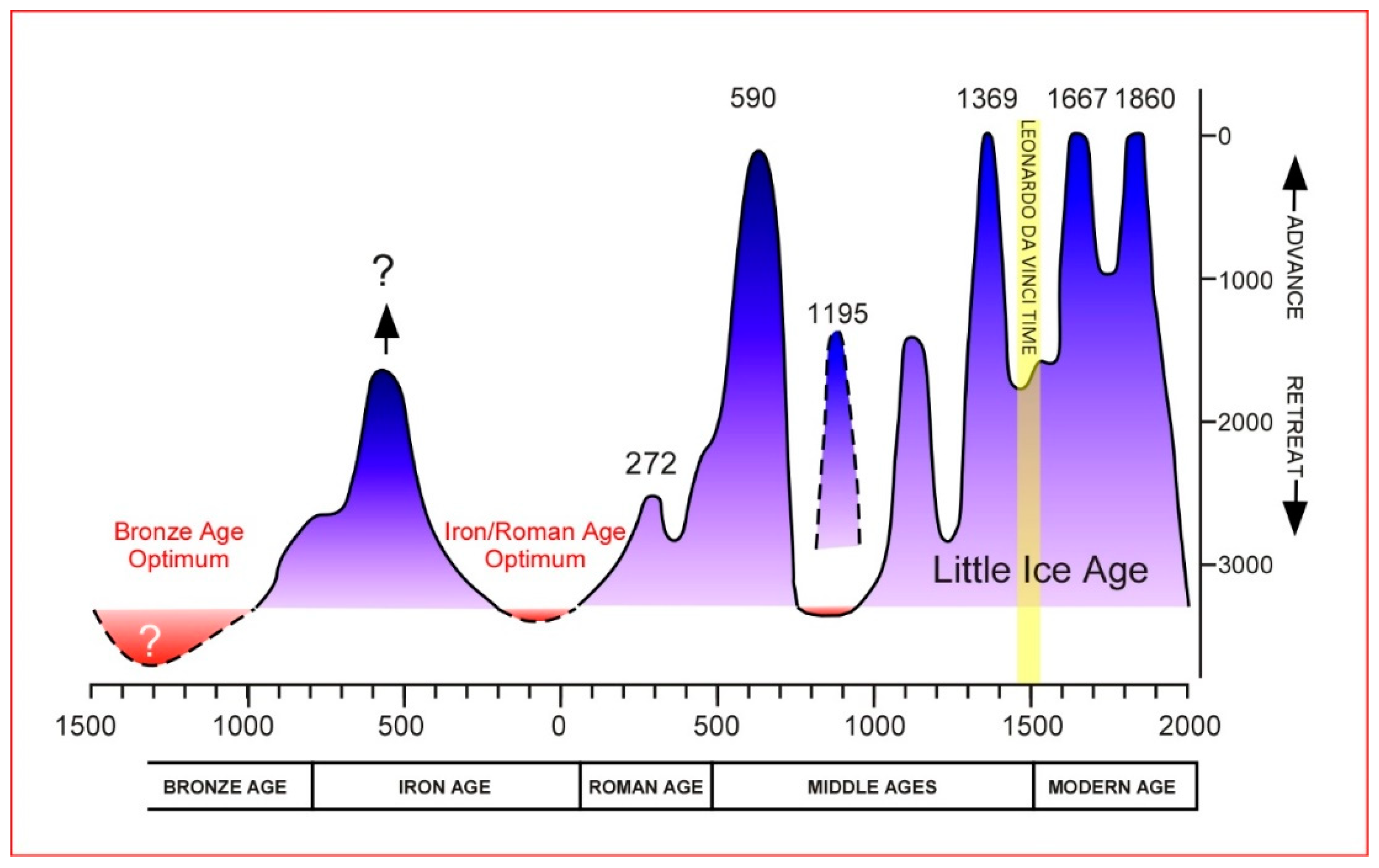
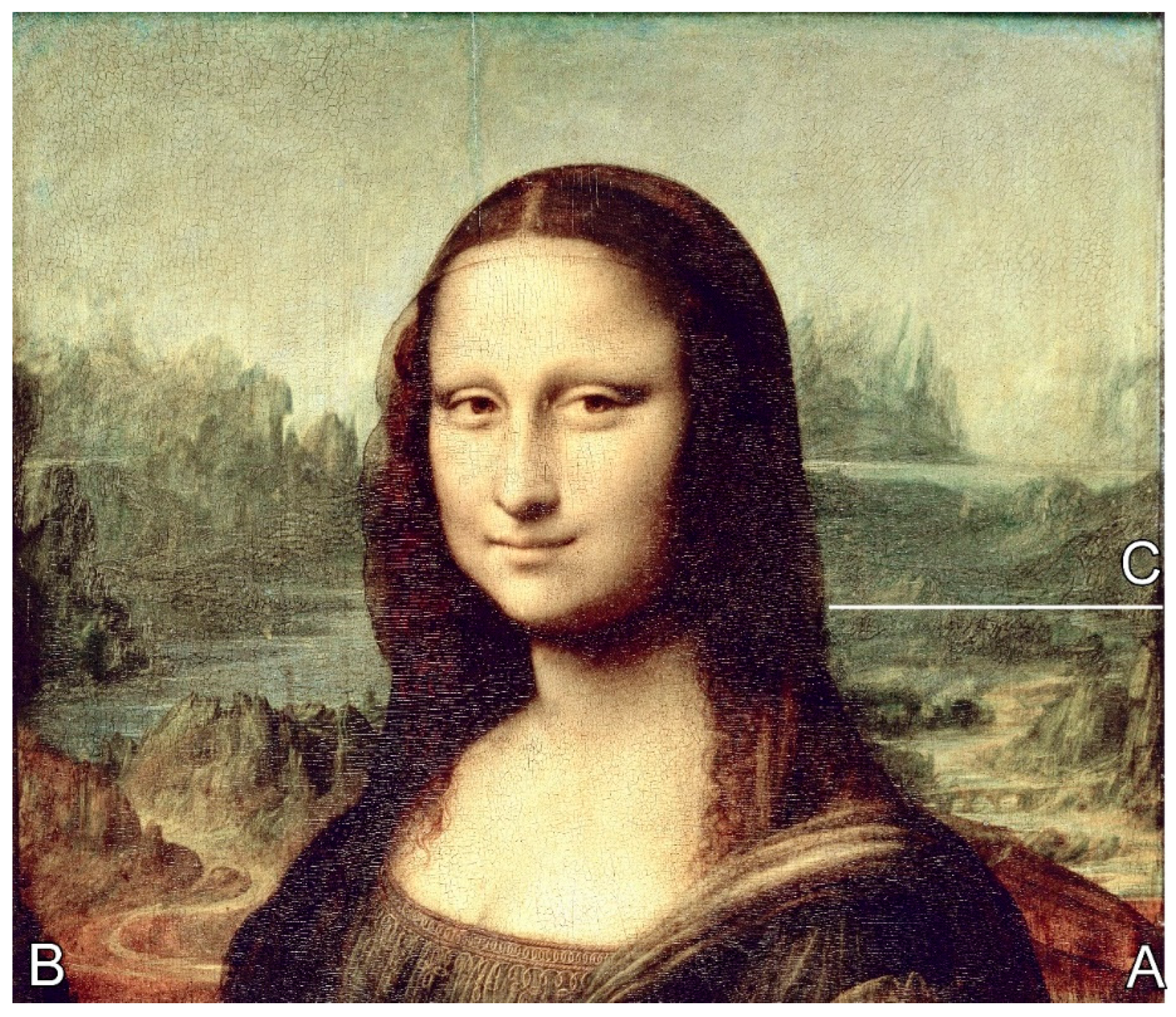
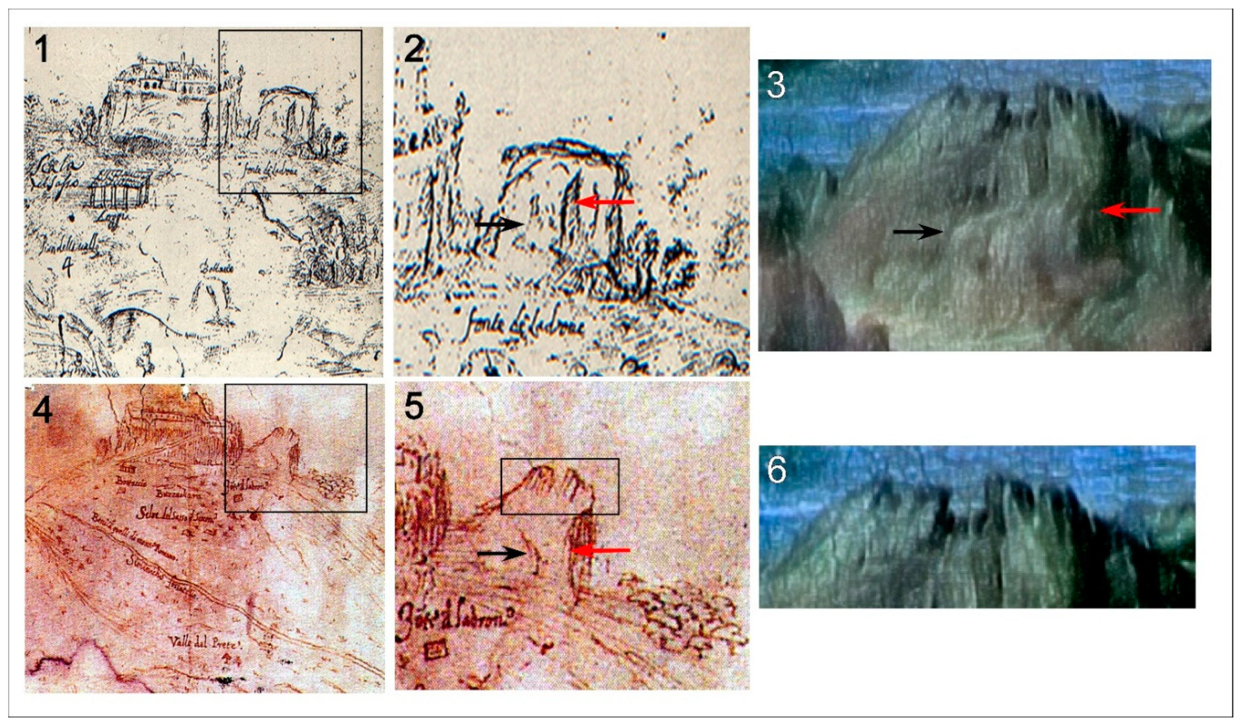
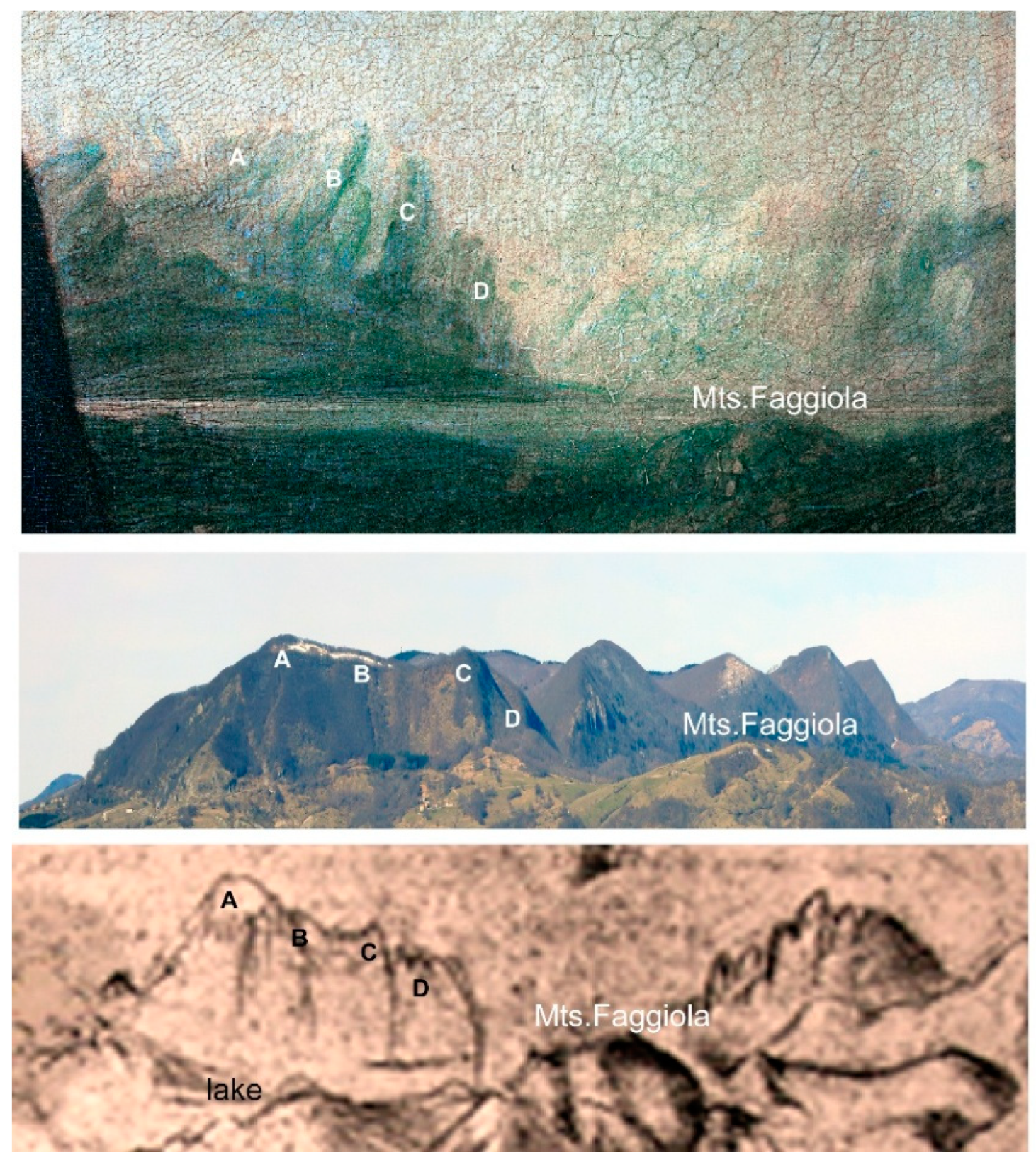
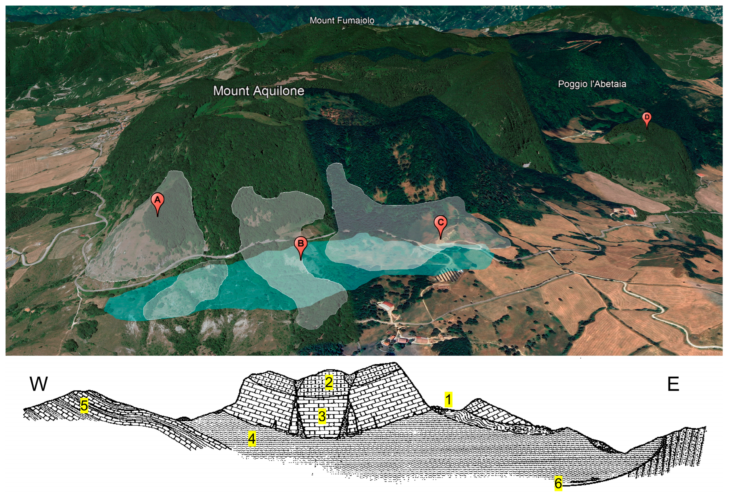
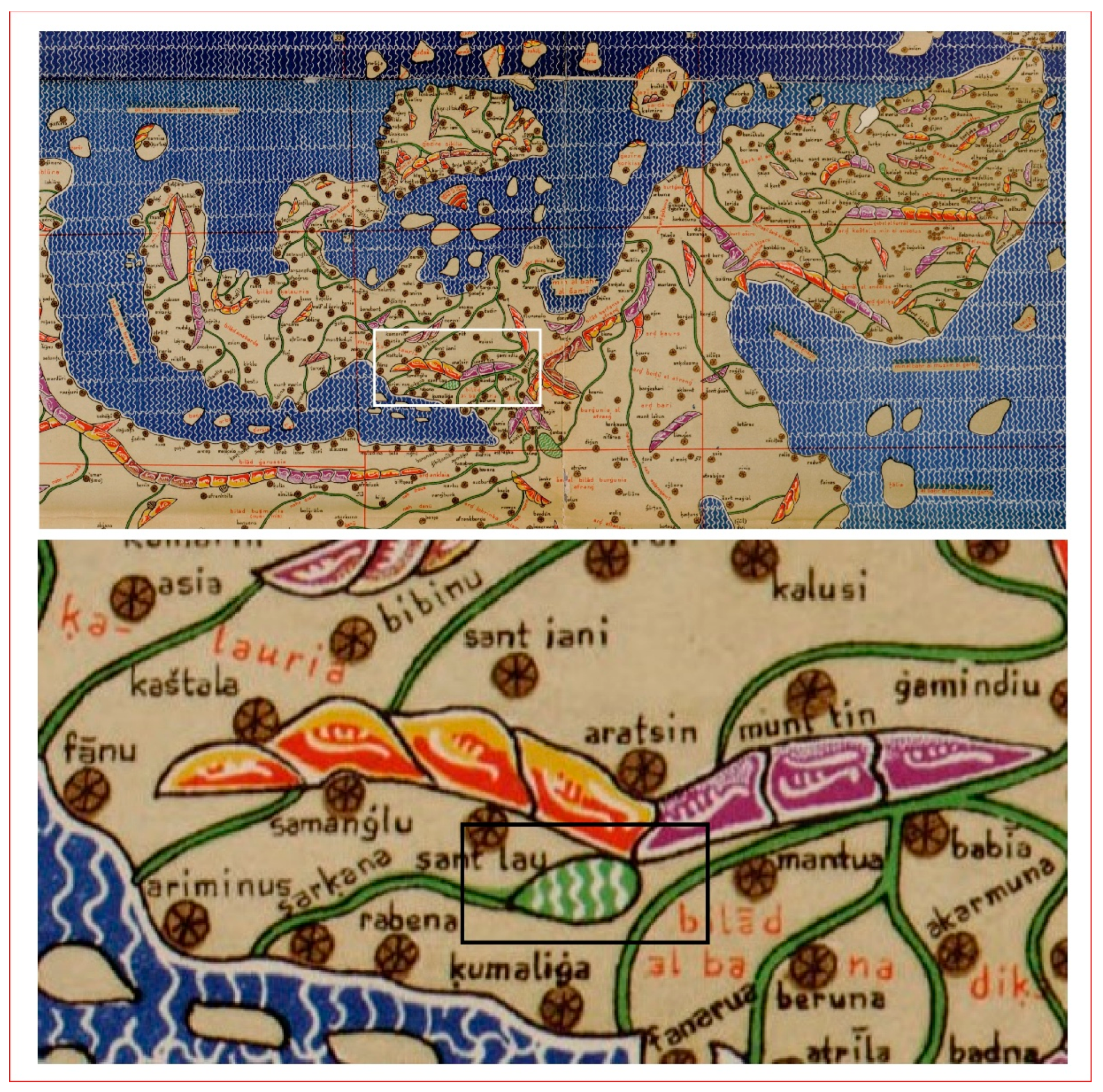
4.2.3. Sector C: Mount Fumaiolo and the Lake, New Geomorphological and Historical Data

The mountainous complex of the Fumaiolo Massif is part of the system of Apennine reliefs that constitute the line of watersheds between the Adriatic and Tyrrhenian slopes. On the latter is the summit of Mount Fumaiolo, where, as is well known, the source of the River Tiber is located. The other reliefs (the Aquilone and Passino Mountains) are part of the Adriatic side, and from them originate the Senatello stream, a tributary of the Marecchia River (Figure 7). The geology of this region is notably complex, characterised by the emergence of the Valmarecchia Nappe, which explains the chaotic appearance of the landscape, dominated by deep-seated gravitational slope deformations and superficial landslides. The severe climate changes during the Quaternary period, acting upon an already deformed and fractured landscape, have further exacerbated the instability of this territory.
If, up to this point, the correspondences between the landscape of the Gioconda and the actual landscape are many and evident, an area with elements to be clarified is that of Mount Aquilone and the lake. The painted landscape, in fact, while showing strong similarities in the morphology of its relief compared to the present one, also presents some morphological differences that deserve further investigation, such as the lake basin that cannot be found in the present landscape. This area is known for the presence of large quantities of water, including the source of the River Tiber. Due to the permeability of the limestones and sandstones of the San Marino and Fumaiolo Formations, resting on a predominantly clayey and marly substratum, a rich water aquifer is generated and flows through numerous springs around the relief [37]. This lithological difference, the fracturing of the rocks, and climatic events that alternated in the Middle–Upper Pleistocene (700,000 years ago) explain the geomorphology of this area, which is characterised by large landslides and thick stratified debris. The latter (Figure 16) are thick talus deposits that can be recognised at the foot slopes. Sometimes, they appear stratified and cemented, suggesting a periglacial origin, and are linked with Quaternary cold climatic phases [38].
Although short-lived, the alternation between cold and warm events has altered the landscape considerably. Despite this, geomorphological analysis has made it possible to identify many elements that have remained intact, such as the crests of Mount Aquilone (Figure 17), but also elements that have been modified, such as slopes affected by landslides and lake basins. Regarding the lake in the painting reproduced in sector C (Figure 10) to the right of the Gioconda, new geomorphological data show that at the base of Mount Aquilone, a depression is found, where the runoff water from numerous springs could collect by virtue of the clay substrate. Subsequent landslides may have caused the lake to disappear, leaving only small, shallow lake depressions. The presence of small lakes and ponds has been known since historical times. Place names everywhere indicate the presence of water (“I Laghi”, “Il Lagaccio”, “Poggio del Passino”, “Costa della Doccia”, “Pescaia”, “Ca’ Bonci”; “Campo di Boncino”—note that “Bonci” is an ancient name of lake fishes; “Mount Aquilone”—note that the ancient toponym is “Acquilone” [39], where “acqua” is “water”).
The area’s morphology, however, does not rule out the presence of a more extensive natural reservoir in earlier times. At the mountain’s base, there is a vast depression (Figure 18) produced by significant gravitational deformations that gave rise to counter-slopes on which runoff water and water from numerous springs could collect. These processes may have formed the lake that Leonardo reproduced at the base of Mount Aquilone. The subsequent occurrence of landslides may have drained the lake, leaving only a few shallow marshy areas.
A wide depression separates the slope from a lowered block on the right of Figure 18 (Poggio l’Abetaia), partially rotated along the fault plane. Many trenches affect the top of the reliefs and the upper part of the slopes. They are parallel to the external escarpments and are generally aligned with the main tectonic directions. Many are filled with debris from the Monte Fumaiolo Formation, and sometimes they have sinkholes. However, these depressions cannot be attributed to a karst genesis, as these sandstones do not have enough carbonate content to allow extensive karst phenomena. Instead, these depressions are related to the opening of fractures, forming “parallel” and “transverse” trenches. The rock escarpments bordering the massif are affected by extensive landslide phenomena, such as block collapses, overthrusts, and, subordinately, planar and wedge slides [37,40,41,42].
The search for cartographic documentation attesting to the presence of a lake basin below the Fumaiolo Massif led to the identification, in the Map of Italy dating back to 1154, of a large lake at the source of the Marecchia River, reported by the Arab geographer Edrisi [43]. In the text in Arabic, annexed to the great Map of Italy and translated in a volume of the Accademia dei Lincei, we read that “the river màr.k.lah” (Marecchia) “originates from a pond copious with water, at the foot of a mountain” (Figure 19) [43].
The probability that a landslide caused the disappearance of the lake beneath Mount Aquilone is supported by the documentation of an earthquake that occurred in 1584, with an epicentre about 13 km northwest of the lake area (Figure 20).
The earthquake produced deep ground breakages, fractures, and a large landslide [44], which caused the devastation of some towns [45,46]. The main seismic shock, with an MCS degree XI (Mercalli–Càncani–Sieberg 1932 scale), 5.8 equivalent magnitude (Me) [47,48], occurred on 10 September 1584, at about 8:30 p.m., in the inner Savio River Valley, on the southeastern slope of the Tuscan–Emilian Apennines (Figure 20). The town nearest to the earthquake epicentre was San Piero in Bagno (FC), which suffered massive damage. Further, a significant landslide movement was triggered by the earthquake about 5 km from the epicentre on the northwestern side of Mount Comero, where the detachment area was recognised (Figure 20) [46,49]. This landslide has been reported in the historical archives, because it reached two villages located about 4 km and 5.5 km north of the landslide main scarp, respectively, and increased the damage to buildings. The hypothesised Mount Aquilone landslide may not have been reported because the area of interest was uninhabited then and later.
Another strong earthquake occurred in the Northern Marchean Apennine on 3 June 1781, with an epicentre at about a 43 km distance southeast of the hypothesised lake area (Figure 21). The epicentre is more distant from Mount Aquilone than the earthquake above. Still, the epicentral intensity (MCS scale) has been estimated at degree X, 6.3 equivalent magnitude (Me), and at degree VII at the location of the nearest area of interest, Pennabilli [47,48]. The earthquake was characterised by two violent seismic shakes about ten minutes from each other. The affected area was huge, up to the South Marche, in all of the Romagna region, and to a maximum distance of more than 200 km towards the north (Figure 21). The earthquake had various effects on the natural environment, including landslides [49,50,51], although quite far from the area of interest. Therefore, it is likely that the first of the two earthquakes may have triggered a landslide in our area of interest.
Figure 20. The 1584 earthquake epicentre, the landslide main scarp position, and the hypothesised lake position (blue polygon) (modified from [47,48,49]). Google Earth Pro (ver. 7.3.6), 43°47′33.08″ N; 12°6′35.97″ E, Mount Fumaiolo Massif; Image Landsat/Copernicus; Airbus 2025.
Land 14 01007 g020

5. Discussion

The mission of a geomorphologist approaching the study of a landscape is to understand the processes that generated it and analyse its evolution, with its variations in time and space. Studying landscape variations over a long time span, such as the Quaternary period, can be relatively simple, as a large amount of stratigraphic, chronological, and morphological data are available. However, those seeking to decipher the landscape depicted in Renaissance paintings must focus on a much more limited period (500–600 years), in which erosional and depositional processes have certainly taken place. Still, the landforms may be underdeveloped and barely visible. In addition to these variations, there are also events that suddenly and profoundly alter the landscape, such as landslides or catastrophic floods caused by particularly intense meteorological and climatic events.
The study of geomorphological features within Renaissance landscape drawings also reveals a complex interaction between art and natural processes. The drawings found in the Arundel and Windsor Codices, attributed to Leonardo da Vinci, are particularly fascinating as they encapsulate the distinctive features of the Montefeltro region. This area, known for its rolling hills, steep ridges, and deeply incised river valleys, provides a rich backdrop that reflects the interplay of climatic, tectonic, and human factors over time. Leonardo’s visits to Montefeltro in 1502 allowed him to directly observe these morphologies, integrating his understanding of landforms into his paintings. His ability to capture specific landscape details—significant from a scientific perspective—is evidence of his keen observation and profound comprehension. Therefore, the geomorphological analysis of these drawings opens a debate on how landscape modifications due to climate change, tectonic shifts, and human interventions can be interpreted. The connection between scientific understanding and artistic representation enriches our knowledge of Leonardo’s work. It enhances our awareness of the dynamic nature of landscapes, highlighting how they evolve and are perceived in different temporal and cultural contexts. This research, therefore, emphasises the importance of interdisciplinary approaches in understanding the historical landscape.
The background of the Gioconda encapsulates a vast range of landforms within a small space, some of which are easily recognisable in today’s landscape, because they have undergone only marginal modifications. Others are difficult to identify, perhaps because they have undergone more profound changes. It is the geomorphologist’s task to verify the consistency of these variations by finding evidence of specific processes.
In the background of the Gioconda, numerous morphological elements (sectors A and B) are perfectly comparable with the current landscape. However, in sector B, Leonardo adopts a technique of spatial compression to depict a large portion of the Duchy of Urbino, captured from a specific viewpoint. In sector A, the morphological elements are recognisable, but anthropic differences can be observed, such as the bridge over the Senatello Torrent. Sector C, finally, is the one that presents the most significant differences compared to the current landscape.

6. Conclusions

In this area, detailed field surveys, research on historical cartographic documents, and data on seismic events have made it possible to reconstruct the original landscape, which at this point perfectly matches the one depicted:
Thanks to the permeability of the limestones resting on a predominantly clayey substrate, a rich aquifer is present in this area, with numerous springs around the relief. Lithological differences, the high fracturing of the limestone rocks, and recent climatic events are responsible for significant landslide phenomena involving large thicknesses of stratified debris. Subsequent landslides may have caused the lake to disappear, leaving only small, shallow lake depressions.
Cartographic documentation attesting to the presence of a lake basin in this area has made it possible to identify the lake located at the source of the Marecchia River [43]. The text annexed to the map clearly states that the Marecchia River originates from a water-rich pond at the foot of a mountain (Figure 19).
The likelihood that a landslide caused the lake’s disappearance under Mount Aquilone is supported by documentation of an earthquake in 1584 (magnitude 5.8), with an epicentre located about 13 km from the lake area. A landslide triggered by this earthquake was reported in historical archives [48,49], because it reached two villages located 4 km and 5.5 km north of the area of interest. The landslide at Mount Aquilone may not have been reported, because the area was utterly uninhabited at that time. Another strong earthquake occurred in 1781 (magnitude 6.3), with an epicentre about 43 km away. Two strong seismic shocks characterised the earthquake, and the affected area was enormous.
This research thus highlights the importance of interdisciplinary approaches in understanding the historical landscape. Identifying the landscape has opened new perspectives for the interpretation of the artwork. In fact, the language of the landscape allows us to access the most hidden and intimate aspects of paintings, shedding light on previously overlooked elements. It is fascinating how the recent history of our land can also be better understood through the backgrounds of Renaissance artworks. The area of the Duchy of Urbino, renowned worldwide for its landscapes of extraordinary beauty and charm and for its unique geological evolution, not only becomes a new horizon of knowledge as “landscape art” but also represents an unexpected cultural resource to be shared, transmitted, and promoted [3,35,52,53].
One of the main results of this research has been the creation of an open-air museum with viewpoints that guide visitors into the extraordinary experience of feeling part of a work of art.
In conclusion, this work, supported by the historical interpretations of an important art historian and scholar of Leonardo da Vinci, Carlo Pedretti [25], and by a wealthy historian internationally known as Roberto Zapperi [26], provides the solution to an enigma that has plagued the entire scientific and cultural community for the past 500 years: who is the woman depicted in this famous painting, in which geographical area is she located, and what mystery lies behind this image?

Author Contributions

Conceptualisation, O.N., R.B. and L.V.; methodology, O.N., R.B. and L.V.; software, G.P. and L.V.; investigation, O.N. and L.V.; data curation, O.N., G.P. and L.V.; writing—review and editing, O.N., G.P. and L.V.; visualisation, O.N., G.P. and L.V.; supervision, O.N. and L.V. All authors have read and agreed to the published version of the manuscript.

Funding

This research received no external funding.

Data Availability Statement

No new data were created or analyzed in this study. Data sharing is not applicable to this article.

Conflicts of Interest

The authors declare no conflicts of interest.

References

  1. Borchia, R.; Nesci, O. Il Codice P., Atlante Illustrato Del Reale Paesaggio Della Gioconda; Electa-Mondadori: Milano, Italy, 2012; pp. 1–143. [Google Scholar]
  2. Nesci, O.; Borchia, R. Landscapes and Landforms of the Duchy of Urbino in Italian Renaissance Paintings. In Landscapes and Lanforms of Italy, World Geomorphological Landscapes; Soldati, M., Marchetti, M., Eds.; Springer International Publishing: Berlin/Heidelberg, Germany, 2017; Volume 22, pp. 257–269. [Google Scholar]
  3. Nesci, O.; Borchia, R.; Valentini, L. The backgrounds of Renaissance paintings in the ancient Duchy of Urbino (Central Italy): Exploring new forms of valorization of Geoheritage through their inclusion in UNESCO cultural landscapes. Geosciences 2024, 14, 76. [Google Scholar] [CrossRef]
  4. Fredi, P.; Lupia Palmieri, E. Morphological Regions of Italy. In Landscapes and Lanforms of Italy, World Geomorphological Landscapes; Soldati, M., Marchetti, M., Eds.; Springer International Publishing: Berlin/Heidelberg, Germany, 2017; Volume 22, pp. 39–74. [Google Scholar] [CrossRef]
  5. Alvarez, W. A review of the Earth history record in the Cretaceous, Paleogene, and Neogene pelagic carbonates of the Umbria- Marche Apennines (Italy): Twenty-five years of the Geological Observatory of Coldigioco. In 250 Million Years of Earth History in Central Italy: Celebrating 25 Years of the Geological Observatory of Coldigioco; Geological Society of America Special Paper 2019; Koeberl, C., Bice, D.M., Eds.; Geological Society of America: Boulder, CO, USA, 2019; Volume 542, pp. 1–58. [Google Scholar] [CrossRef]
  6. Scisciani, V. Styles of positive inversion tectonics in the Central Apennines and in the Adriatic foreland: Implications for the evolution of the Apennine chain (Italy). J. Struct. Geol. 2009, 31, 1276–1294. [Google Scholar] [CrossRef]
  7. Mariucci, M.T.; Amato, A.; Montone, P. Recent tectonic evolution and present stress in the Northern Apennines (Italy). Tectonics 2010, 18, 108–118. [Google Scholar] [CrossRef]
  8. Boccaletti, M.; Corti, G.; Martelli, L. Recent and active tectonics of the external zone of the Northern Apennines (Italy). Int. J. Earth Sci. (Geol. Rundsch) 2010, 100, 1331–1348. [Google Scholar] [CrossRef]
  9. Deiana, G.; Pialli, G. The structural provinces of the Umbro-Marchean Apennines. Mem. Soc. Geol. It. 1994, 48, 473–484. [Google Scholar]
  10. De Feyter, A.J. Gravity tectonics and sedimentation of the Montefeltro, ltaly. Geol. Ultraiect. 1991, 35, 1–168. [Google Scholar]
  11. Passeri, L. Appennino Umbro-Marchigiano. Guide Geologiche Regionali 7. Società Geologica Italiana; BE-MA: Milano, Italy, 1994; pp. 1–301. [Google Scholar]
  12. Barchi, M.R.; Alvarez, W.; Shimabukuro, D.H. The Umbria-Marche Apennines as a double orogen: Observations and hypotheses. Ital. J. Geosci. 2012, 131, 258–271. [Google Scholar] [CrossRef]
  13. Bartolini, C. When did the Northern Apennine become a mountain chain. Quat. Int. 2003, 101–102, 75–80. [Google Scholar] [CrossRef]
  14. Mazzanti, R.; Trevisan, L. Evoluzione della rete idrografica nell’Appennino centro-settentrionale. Geogr. Fis. Dinam. Quat. 1978, 1, 55–62. [Google Scholar]
  15. Mazzoli, S.; Deiana, G.; Galdenzi, S.; Cello, G. Miocene fault-controlled sedimentation and thrust propagation in the previously faulted external zones of the Umbria-Marche Apennines, Italy. EGU Stephan Mueller Spec. Publ. Ser. 2002, 1, 195–209. [Google Scholar] [CrossRef]
  16. Conti, S. Geologia dell’Appennino marchigiano romagnolo tra le valli del Savio e del Foglia (Note illustrative alla carta geologica a scala 1:50.000). Boll. Soc. Geol. It. 1989, 108, 453–490. [Google Scholar]
  17. Perrone, V.; Terrotta, S.; Marsaglia, K.; Distaso, A.; Tiberi, V. The Oligocene ophiolite derived breccias and sandstones of the Val Marecchia Nappe: Insights for paleogeography and evolution of Northern Apennines (Italy). Palaeogeogr. Palaeoclimatol. Palaeoecol. 2014, 394, 128–143. [Google Scholar] [CrossRef]
  18. Pignone, R.; Cazzoli, M.A.; Daniele, G.; Lucente, C.C. Itinerari Geologico-Ambientali Nella Valle Del Marecchia; Scala 1:60.000; Servizio Geologico, Sismico e dei Suoli, Regione Emilia Romagna: Bologna, Italy, 2015. [Google Scholar]
  19. Nesci, O.; Savelli, D.; Troiani, F. Types and development of stream terraces in the Marche Apennines (central Italy): A review and remarks on recent appraisals. Géomorphologie 2012, 2, 215–238. [Google Scholar] [CrossRef]
  20. Calderoni, G.; Cilla, G.; Dramis, F.; Gobbi, C. Environmental changes and human settlement in the central Marches (Italy) during the early-middle Holocene. Physio-Geo 2007, 1, 21–32. [Google Scholar] [CrossRef]
  21. Veggiani, A. Variazioni Climatiche e Trasformazioni Ambientali nel Montefeltro Marecchiese in Epoca Storica Con Riferimenti al Territorio di Casteldelci; Le Penne: Casteldelci, Italy, 1994; p. 48. [Google Scholar]
  22. Holzhausen, H.; Magny, M.; Zumbuühl, H.J. Glacier and lake-level variations in west-central Europe over the last 3500 years. Holocene 2005, 15, 789–801. [Google Scholar] [CrossRef]
  23. Mann, M.E. Little ice age. In The Earth System: Physical and Chemical Dimensions of Global Environmental Change, Vol 1, Encyclopedia of Global Environmental Change; Mac Cracken, M.C., Perry, J.S., Eds.; Wiley: Chichester, UK, 2002; pp. 504–509. [Google Scholar]
  24. Orombelli, G. Holocene mountain glacier fluctuations: A global overview. Geogr. Fis. Dinam. Quat. 2011, 34, 17–24. [Google Scholar]
  25. Pedretti, C. Studi Vinciani, Documenti, Analisi e Inediti leonardeschi; Librairie e Droz.: Genève, Switzerland, 1957; pp. 1–306. [Google Scholar]
  26. Zapperi, R. Abschied von Mona Lisa Das berühmteste Gemälde Der Welt Wird Enträtselt; C.H. Beck Verlag: München, Germany, 2010; pp. 1–159. [Google Scholar]
  27. Bortolin, G.A.; Tartari, C.A. D’illustri Città, Messeri e Leggiadre Madonne: The journey of Cardinal Luigi d’Aragona to Germany, Holland, France and Italy, 1517–1518 Written by Antonio de Beatis, Transposed from the Original in the Vernacular, Ludwig Pastor Ed. (Friburgo in Brisgovia, 1905); Terra Santa Ed.: Milano, Italy, 2012; pp. 1–208. [Google Scholar]
  28. Perrig, A. Leonardo: Die Anatomie der Erde. Jahrb. Hambg. Kunstsammlungen 1980, 25, 51–80. [Google Scholar]
  29. Coccioni, R. Leonardo da Vinci, Rocce, Fossili e Altre Simili Cose; Aras Ed.: Fano, Italy, 2019; pp. 1–241. [Google Scholar]
  30. Nanni, R. Usi diversi di appunti di paesaggio in Leonardo. In Leonardo Genio e Cartografo. La Rappresentazione del Territorio Tra Scienza e Arte; A cura di Andrea Cantile, Istituto Geografico Militare: Firenze, Italy, 2003; pp. 263–275. [Google Scholar]
  31. Starnazzi, C. Le Carte di Leonardo: Un nuovo concetto di spazio. In Leonardo Genio e Cartografo. La Rappresentazione del Territorio tra Scienza e Arte; A cura di Andrea Cantile, Istituto Geografico Militare: Firenze, Italy, 2003; pp. 277–297. [Google Scholar]
  32. Guerra, C. Amazing history of an amazing landscape. In A Treasure of Nature. Colors, Scents, Silences and Noises Along the Marecchia and Conca Valleys; Guaitoli, S., Ed.; Lithos arti grafiche: Villa Verucchio, Italy, 2020; pp. 33–39. [Google Scholar]
  33. Sacco, D. Archeologia dei paesaggi in Leonardo da Vinci: Analisi di un attraversamento. In Il Codice P. Atlante Illustrato del Paesaggio Reale Della Gioconda; Borchia, R., Nesci, O., Eds.; Electa Mondadori: Milano, Italy, 2012; pp. 134–141. [Google Scholar]
  34. Valentini, L.; Guerra, V.; Nesci, O. The Mt. Catria–Mt. Nerone Ridge in the North-Marchean Apennines (Central Italy): A Potential Geopark? Sustainability 2023, 15, 11382. [Google Scholar] [CrossRef]
  35. Valentini, L.; Nesci, O. A new approach to enhance the appeal of the Italian territory through art: Three study cases from Marche Region. Arab. J. Geosci. 2021, 14, 144. [Google Scholar] [CrossRef]
  36. Vona, S. I Castelli in Leonardo da Vinci. In Il Codice P. Atlante Illustrato del Paesaggio Reale Della Gioconda; Borchia, R., Nesci, O., Eds.; Electa Mondadori: Milano, Italy, 2012; pp. 142–143. [Google Scholar]
  37. Canuti, P.; Casagli, N.; Garzonio, C.A.; Vannocci, P. Lateral spreads and landslide hazards in the Northern Apennine. The example of Mt. Fumaiolo (Emilia-Romagna) and Chiusi della Verna (Tuscany). In Proceedings of the 6th International Congress International Association of Engineering Geology, Amsterdam, The Netherlands, 6–10 August 1990; pp. 1525–1533. [Google Scholar]
  38. Coltorti, M.; Dramis, F.; Pambianchi, G. Stratified slope-waste deposits in the Esino river basin (Umbria-Marche Apennines, Central Italy). Polarforsch. Bremerhav. Alfred Wegener Inst. Polar Mar. Res. Ger. Soc. Polar Res. 1983, 53, 59–66. [Google Scholar]
  39. Repetti, E. Dizionario Geografico Fisico Storico Della Toscana; Ed. coi tipi di Giovanni Massoni: Firenze, Italy, 1843; pp. 1–868. [Google Scholar]
  40. Persi, P.; Veggiani, A.; Lombardi, F.V.; Battistelli, M.; Renzi, G.; Allegretti, G. Le Frane Nella Storia Della Valmarecchia; Le Penne Ed: Pesaro, Italy, 1993; pp. 1–110. [Google Scholar]
  41. Piastra, S.; Landuzzi, A.; Cencini, C. Historical landslides (XVII–XIX centuries) from Romagna Apennines, Northern Italy. A cultural approach. In Proceedings of the 6th International Congress on Geomorphology, Zaragoza, Spain, 7–11 September 2005; p. 410. [Google Scholar]
  42. Gambi, L. I laghi di frana dell’Appennino Romagnolo. Boll. Soc. Geogr. It. 1948, 1, 10–54. [Google Scholar]
  43. Amari, M.; Schiapparelli, C. L’Italia Descritta nel Libro del Re Ruggero l Compilato da EDRISI. Testo Arabo Pubblicato con Versione e Note; Atti della Reale Accademia dei Lincei: Roma, Italy, 1883; 1876/77, Serie 2; Volume VIII, pp. 1–155. [Google Scholar]
  44. Dramis, F.; Farabollini, P.; Gentili, B.; Pambianchi, G. Neotectonic and large-scale gravitational phenomena in the Umbria-Mar- che Apennines, Italy. In Steepland Geomorphology; Slaymaker, O., Ed.; Wiley: Chichester, UK, 1995; pp. 199–217. [Google Scholar]
  45. Mantovani, E.; Viti, M.; Cenni, N.; Babbucci, D.; Tamburelli, C.; Baglione, M.; D’Intinosante, V. Seismotectonics and present seismic hazard in the Tuscany–Romagna–Marche–Umbria Apennines (Italy). J. Geodyn. 2015, 89, 1–14. [Google Scholar] [CrossRef]
  46. Frosali, L. Le frane della valle del Savio e le opere di consolidamento necessarie. In Rivista Tecnica del Collegio Nazionale Degli Ingegneri Provinciali e Comunali; Vallardi Editore: Milano, Italy, 1916; pp. 10–17. [Google Scholar]
  47. Guidoboni, E.; Ferrari, G.; Mariotti, D.; Comastri, A.; Tarabusi, G.; Sgattoni, G.; Valensise, G. CFTI5Med, Catalogo dei Forti Terremoti in Italia (461 a.C.-1997) e Nell’area Mediterranea (760 a.C.-1500); Istituto Nazionale di Geofisica e Vulcanologia (INGV): Bologna, Italy, 2018. [Google Scholar] [CrossRef]
  48. Guidoboni, E.; Ferrari, G.; Tarabusi, G.; Sgattoni, G.; Comastri, A.; Mariotti, D.; Ciuccarelli, C.; Bianchi, M.G.; Valensise, G. CFTI5Med, the new release of the catalogue of strong earthquakes in Italy and in the Mediterranean area. Sci. Data 2019, 6, 80. [Google Scholar] [CrossRef]
  49. Zei, C.; Tarabusi, G.; Ciuccarelli, C.; Burrato, P.; Sgattoni, G.; Taccone, R.C.; Mariotti, D. CFTIlandslides, Italian Database of historical earthquake-induced landslides. Sci. Data 2024, 11, 834. [Google Scholar] [CrossRef]
  50. Baratta, M. Sul terremoto di Cagli del 3 giugno 1781. In Memorie Della Società Geografica Italiana; Nabu Press: Roma, Italy, 1896; Volume 5, pp. 363–383. [Google Scholar]
  51. Keefer, D.K. Landslides caused by earthquakes. GSA Bull. 1984, 95, 406–421. [Google Scholar] [CrossRef]
  52. Valentini, L.; Guerra, V.; Lazzari, M. Enhancement of Geoheritage and Development of Geotourism: Comparison and Inferences from Different Experiences of Communication through Art. Geosciences 2022, 12, 264. [Google Scholar] [CrossRef]
  53. Nesci, O.; Valentini, L. Science, poetry, and music for landscapes of the Marche Region, Italy: Communicating the conservation of the natural heritage. Geosci. Commun. 2020, 3, 393–406. [Google Scholar] [CrossRef]
Figure 1. Location map of the ancient Duchy of Urbino. The black dashed line indicates the extension of the duchy, while the white dashed line refers to the current regional boundaries.
Land 14 01007 g001
Figure 2. Aerial view of Sassi Simone and Simoncello (limestones and sandstone from San Marino and Fumaiolo Formations; Valmarecchia Nappe, Central Italy).
Land 14 01007 g002
Figure 3. Typical landscape of the Valmarecchia Nappe.
Land 14 01007 g003
Figure 4. Climatic variations of the last 3500 years inferred from the modifications of the Aletsch glacier front. In red, hottest climate; in purple-blue, coldest climate (modified and redrawn after [22]).
Land 14 01007 g004
Figure 5. Raphael, Coronation of Charlemagne, 1517, Rome, Vatican. In the representation, the young Ippolito holds the imperial crown that his uncle Pope Leo X placed on Charlemagne’s head.
Land 14 01007 g005
Figure 6. Digital models of the area represented behind the Gioconda.
Land 14 01007 g006
Figure 7. Location of the main places recognised in the present-day landscape: 1. Fumaiolo Massif; 2. Faggiola Mountains; 3. Mount Rotondo and Mount Tesoro; 4. Poggio Calanco; 5. Santa Maria in Sasseto; 6. Pescaia; 7. Casteldelci; 8. Fragheto; 9. Montevecchio; 10. Mount Zucchetta; 11. Mount Loggio; 12. Santa Sofia; 13. Gattara; 14. Mount Faggiola, 15. Pozzale; 16. Pennabilli; 17. Boncino Plains; 18. Marecchia River; 19. Senatello stream; 20. Badia Tedalda; 21. Palazzaccio; 22. Bascio; 23. Osteriaccia; 24. Ca’ Raffaello; 25. Alpe della Luna; 26. Apennine ridge Catria–Nerone; 27. Sassi Simone and Simoncello.
Land 14 01007 g007
Figure 8. (Above), the Gioconda bridge. (Below) are the large boulders in the Marecchia River, rooted in the alluvial plain. Right, a solarised aerial photo of the Marecchia riverbed from 1974 shows a buried line (red arrow) visible right where the ancient bridge stood.
Land 14 01007 g008
Figure 9. In the current landscape (Above), at the base of Mount Aquilone, a lake has been replaced in the large sunken area (A), as painted in the Gioconda landscape (Below). Note the drainage channel B, which is still visible. On the right is an enlargement of the details in B.
Land 14 01007 g009
Figure 10. The landscape of the Gioconda, divided into three sectors: (A) The bridge near Pennabilli village and the midway Senatello Valley. (B) The left side of the painting. (C) Mount Fumaiolo and the lake.
Land 14 01007 g010
Figure 11. Map of the master roads between Pennabilli and Casteldelci; on the left is the position of the bridge [33].
Land 14 01007 g011
Figure 12. A detail of the painting (left) compared with a Digital Elevation Model (DEM) of the mid-Marecchia Valley (right). (A) Pozzale; (B) Penna and Billi crags. In red, the location of the bridge.
Land 14 01007 g012
Figure 13. View of Mount Aquilone and the Faggiola Mounts, compared with a drawing (Below) by Leonardo (1510–1511, Windsor, Royal Borough Museum Collection), and the same detail in the Gioconda painting (Above). Inside the white square, geomorphological structures called flatirons are visible. At the bottom, a particular of the drawing (Left) is compared with a recent photo of Mount Aquilone (Right). The black arrows indicate the main scarp of the landslide, which is incipient in the drawing and more developed at present.
Land 14 01007 g013
Figure 14. Comparison of the Senatello Valley, from the slopes of Monte Faggiola to the confluence with the Marecchia River, in the present landscape (left) and the painting (right). (A) Faggiola Mounts; (B) esplanade of Poggio Calanco under the Faggiola Mounts; (C, D, E) valley profiles, including Mount Tesoro and Monterotondo; (F) Pozzale; (G) Montevecchio; (H) Mount Zucchetta.
Land 14 01007 g014
Figure 15. (1,4) Ideographic drawings of Sasso Simoncello (16th century, Carpegna municipal archives). (2,5) Details of the drawings showing Sasso Simoncello. (3,6) The same details in the painting. Erosion towers (inside the black squares) are evident in the drawings and the painting. The black arrow indicates a landslide accumulation; the red arrow indicates a vertical fracture.
Land 14 01007 g015
Figure 16. Mount Aquilone: stratified and rotated slope deposits. Alternating horizons of coarse sands with gravels and pebbles and horizons of coarser materials [37]. The clasts mainly belong to the limestones of the San Marino Formation and, subordinately, to the sandstones of the Mount Fumaiolo Formation.
Land 14 01007 g016
Figure 17. The Fumaiolo Massif. Comparison between the painting, the actual landscape, and the drawing by Leonardo (1510–1511, Royal Collection, Windsor Castle). Letters A, B, C, and D correspond to similar morphologies between the Mount Aquilone (A) and Mount Passino (C) peaks. On the right-hand side of the painting, the shape of the hills is covered by clouds.
Land 14 01007 g017
Figure 18. (Above) Perspective view of the eastern slope of the Fumaiolo Massif with a drawing of the lake. (A) Landslide of Mount Aquilone, also reproduced by Leonardo (see Figure 17). (B. and C) Stratified slope deposits mobilised by landslides that led to the lake’s extinction; the white filled areas represent the landslide accumulations. (D) The limestone block of Poggio Abetaia, produced by a lateral displacement responsible for the formation of one depression. Google Earth Pro (ver. 7.3.6), 43°47′33.08″ N; 12° 6′35.97″ E, Mount Fumaiolo Massif; Image Landsat/Copernicus; Airbus 2025. (Below) Schematic section of the Fumaiolo Massif (modified after [37]). (1) Debris; (2) Monte Fumaiolo Formation; (3) San Marino Formation; (4) clay substrate from the “Valmarecchia Nappe”; (5) autochthonous substrate; (6) overthrust.
Land 14 01007 g018
Figure 19. Edrisi Map (1154) or Tabula Rogeriana of the Italian peninsula (Above). At the top is the south (as was the custom at the time). (Below) are details of the lake at the Marecchia River source.
Land 14 01007 g019
Figure 21. The 1781 earthquake epicentre and the hypothesised lake position (blue polygon northwest of the epicentre, evidenced by the red arrow) (modified from [47,48]). Google Earth Pro (ver. 7.3.6), 43°47′33.08″ N; 12°6′35.97″ E, Mount Fumaiolo Massif; Image Landsat/Copernicus; Airbus 2025.
Land 14 01007 g021
Disclaimer/Publisher’s Note: The statements, opinions and data contained in all publications are solely those of the individual author(s) and contributor(s) and not of MDPI and/or the editor(s). MDPI and/or the editor(s) disclaim responsibility for any injury to people or property resulting from any ideas, methods, instructions or products referred to in the content.

