Article

Impact of Future Urban Expansion on Endemic Species in China at the Species Level

1
Guangdong Key Laboratory for Urbanization and Geo-Simulation, School of Geography and Planning, Sun Yat-sen University, Guangzhou 510275, China
2
Division of Landscape Architecture, Faculty of Architecture, The University of Hong Kong, Hong Kong SAR, China
3
Southern Marine Science and Engineering Guangdong Laboratory (Zhuhai), Zhuhai 519082, China
*
Author to whom correspondence should be addressed.
Land 2025, 14(5), 1005; https://doi.org/10.3390/land14051005
Submission received: 20 March 2025 / Revised: 25 April 2025 / Accepted: 2 May 2025 / Published: 6 May 2025

Abstract

:
With accelerating urbanization, urban expansion poses a significant threat to biodiversity, especially to endemic species, which are more sensitive to land use changes. However, to date, the impacts of future urban expansion at the species level in China on endemic species remain unclear. This study aims to comprehensively evaluate the impact of future urban expansion on endemic species in China under the framework of the shared socioeconomic pathways (SSPs) from 2015 to 2050 using multiple indicators, including suitable habitat area changes, habitat fragmentation, and species extinction risk. The results show that from the perspective of suitable habitat loss and extinction risk, the negative impact of urban expansion in China from 2015 to 2050 may be greater for endemic species than for other species with a wide distribution. In addition, more than 56% of the affected species suffer from exacerbated habitat fragmentation. Biodiversity loss is more serious in regions with high endemic species richness and in urban agglomerations with rapid urban development in the future. Endemic birds and amphibians show high sensitivity to threats of urban expansion from various perspectives. This study provides a basis for biodiversity conservation, guiding the balance between urban development and biodiversity protection.

1. Introduction

Biodiversity is important to the Earth’s life-support system and fundamental to sustaining human well-being [1]. In the past century, the rate of biodiversity loss caused by human activities has far exceeded that of the Cenozoic era [2]. Around 25% of species within the evaluated animal and plant groups are identified as threatened [3]. Biodiversity is facing increasing pressures from human activities, including habitat conversion and degradation, habitat fragmentation, climate change, logging, and pollution [4]. Although the direct factors underlying these threats are varied, the primary driving force is the demand for additional land and natural resources driven by population and economic growth [5]. Urban expansion, among the many human activities leading to habitat loss, is associated with the highest local extinction rates of species and more lasting effects on habitats [6].
With accelerating urbanization, expanded urban lands increasingly threaten biodiversity by directly causing habitat loss, fragmentation, and degradation, which disrupt ecosystems and reduce species populations [7]. Globally, an assessment of over 30,000 species indicates that global urban expansion from 2015 to 2050 may result in the loss of suitable habitats for 26–39% of the evaluated species [8]. Additionally, future global urban expansion is projected to lead to a 34% decline in species richness and a 52% reduction in species abundance. Moreover, urban expansion can affect adjacent natural habitats by reducing their proximity to urban areas and increasing habitat fragmentation through patch isolation and higher edge density, as observed or projected across multiple scales [9,10,11]. Thus, it is projected that global urban land may prevent nearly 40% of ecoregions from meeting the 2050 biodiversity conservation targets [12].
Endemic species are more sensitive to land use changes, given their narrow ecological niches and limited geographic ranges [13]. McDonald et al. [14] evaluated the level of species endemism within ecoregions and overlaid the results with projected newly added urban land. The findings indicate that from 2000 to 2030, 12.5% of terrestrial vertebrate endemics will face high threats caused by global urban growth. Within the 30 ecoregions identified for priority conservation of endemic species, the Serra do Mar coastal forests in Brazil, the South China–Vietnam subtropical evergreen forests in China, and the Albertine Rift montane forests in Africa are the top three regions experiencing the greatest habitat loss from urban expansion. In addition, biodiversity hotspots are areas recognized for their exceptional levels of biological diversity and their large number of endemic species [15]. Many studies thus assessed urban expansion within biodiversity hotspots. For example, using spatial overlay analysis, a study shows that the urban lands within biodiversity hotspots are expected to grow by 436,175 km2 globally by 2030, with a net growth of more than 200% relative to the year 2000 [16]. Especially in regions with projected rapid urbanization, such as China, South America, Western Asia, Southeast Asia, and Mid-Latitudinal Africa, the area of urban land near biodiversity hotspots is forecast to increase rapidly, posing threats to endemic species [17]. Furthermore, some local-scale studies assessed the responses of endemic species to urban expansion through field investigations. For instance, in the Mondah forest of Gabon, urbanization affected all 24 species identified as endemic by the IUCN (International Union for Conservation of Nature) Red List of Threatened Species [18]. Moreover, in Margarita Island, Venezuela, urbanization has led to a simplification of bird assemblages at both the guild and species levels, yet the displacement of endemic species by introduced exotics has not been observed [19]. However, current large-scale studies generally focus on only one aspect of biodiversity, and species-level assessments remain lacking.
China’s urbanization has progressed with exceptional speed, making it one of the fastest in the world [20]. From 1995 to 2018, China’s built-up area experienced a remarkable growth of 287.60% [21]. In addition, according to a 2050 projection, the built-up area in China is expected to increase by 13–59% compared to the year 2010 [22]. Land competition between high-intensity urban development and natural habitats presents a major threat to biodiversity in China. Such a challenge is likely to remain in the foreseeable future. As a result, the survival of China’s endemic species may also be increasingly under threat. According to the 2015 assessment report [23], vertebrates in China exhibit a high level of endemism. Specifically, 36.7% of the species are endemic to China. Endemic mammals account for 22.3% of all mammalian species in China. Among them are the globally recognized giant panda (Ailuropoda melanoleuca), the golden snub-nosed monkey (Rhinopithecus roxellana), and the wild yak (Bos mutus). Regarding birds, China is one of the most bird-diverse countries in the world, with over 1300 species. Although there are fewer than 100 endemic bird species, 37.7% of them are threatened. Furthermore, with over 270 endemic amphibian species, China is recognized as a priority area for global amphibian conservation, given its high levels of diversity and endemism. However, the future responses of China’s endemic species to urban expansion remain unclear.
Therefore, this study aims to evaluate the impacts of future urban expansion in China from 2015 to 2050 on endemic species, using three biodiversity assessment methods to provide a comprehensive analysis. Firstly, changes in suitable habitat area for over 400 national-level endemic species in China due to urban expansion were assessed. Secondly, the extent of fragmentation of suitable habitats for these species was analyzed to understand the natural habitat disruption. Finally, the countryside species–area relationship (cSAR) model was used to assess the loss of ecoregion-level endemic species richness caused by urban expansion.
To explore sustainable development pathways for balancing urban growth and biodiversity conservation, we compared the differences in the responses of endemic species to urban expansion in China under three shared socioeconomic pathways (SSPs). The SSPs characterize future socioeconomic development pathways from the perspective of demographics, economy, lifestyle, institution, technology, environment, and resources [24]. We chose the three scenarios of SSP1, SSP3, and SSP5 because these three scenarios depict development pathways with remarkable differences. This allows us to obtain a comprehensive and comparative perspective for studying the impact of urbanization on biodiversity in China. SSP1 is a sustainable and green pathway, featuring a high level of environmental protection and land regulation [25]. SSP3 is a regional rivalry pathway. In SSP3, developing countries suffer from slow economic development, but experience rapid population growth, resulting in heavier environmental pressure [26]. SSP5 is a fossil-fueled development pathway with rapid global economic growth, but people face serious mitigation challenges [27].

2. Materials and Methods

2.1. Land Use/Cover Data
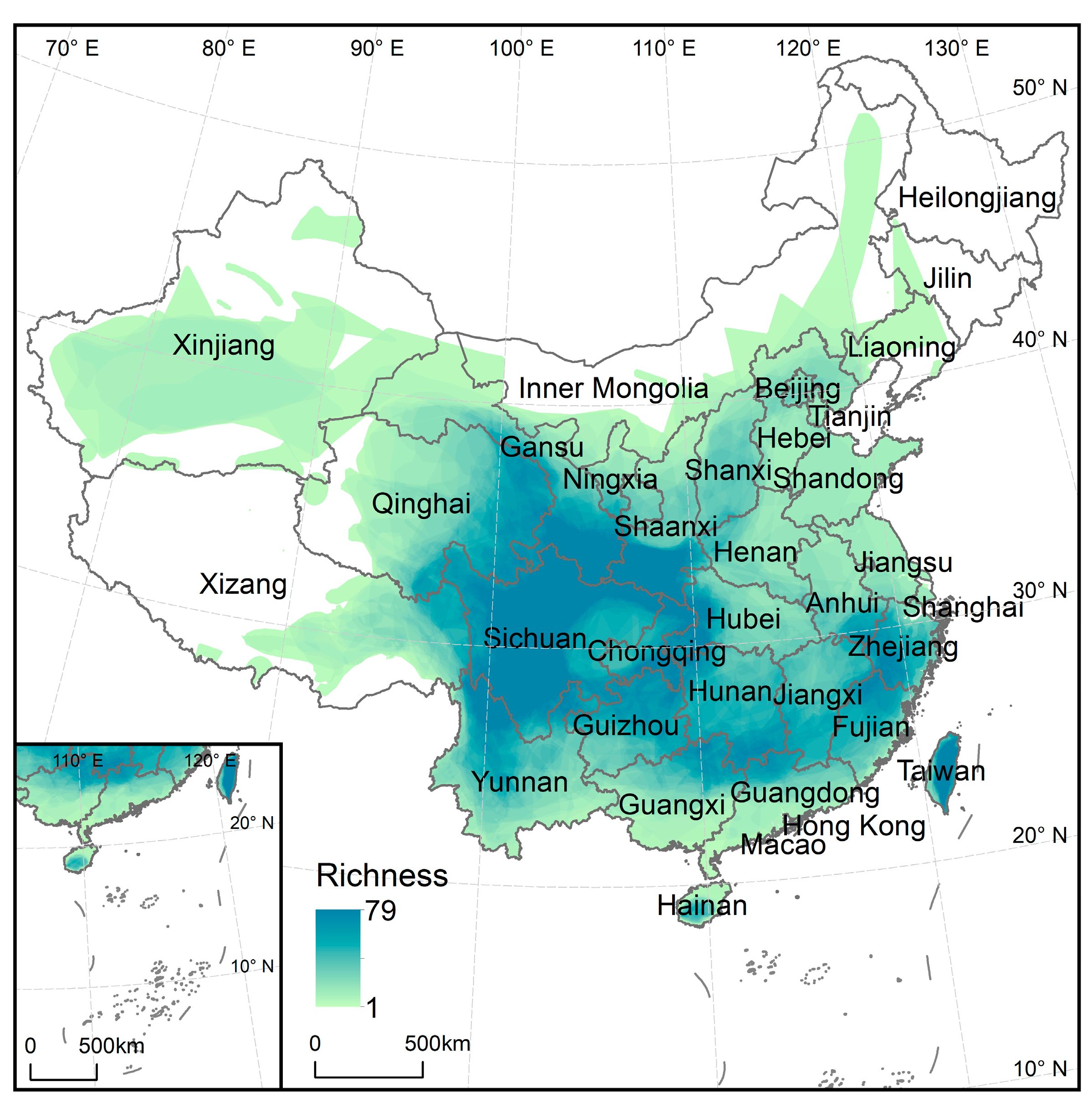
The spatially explicit projections of China’s future urban land for the year 2050 were obtained from a previous study conducted by Chen et al. [28]. Firstly, based on the urbanization rate and GDP, this product used the panel regression method to predict the urban land demand of 32 regions around the world in the future. China was one of the independent regions. For historical periods, urban land area was derived from the Global Human Settlement Layer [29]. Population and urbanization rate data were obtained from the United Nations, while GDP data were sourced from the World Bank. For future periods, population, urbanization rate, and GDP data were all sourced from the SSP database. Then, based on the ANN algorithm, the urban development potential was predicted using a series of spatial driving factors including climatic, topographic, and socioeconomic factors. Finally, the future land use simulation (FLUS) model [30] was used to simulate the distribution of global urban land under five SSP scenarios at a 1 km resolution, with the ESA CCI-LC (European Space Agency Climate Change Initiative Land Cover) product for the year 2015 as the initial map.
Based on the CCI-LC data from 2000 to 2015, Chen et al. [28] validated the simulated product using the Figure of Merit (FoM) indicator [31]. FoM can be calculated as the ratio of the correct predicted change to the sum of the observed change and the predicted change. According to previous land simulation studies, an FoM value in the range of 0.1–0.3 indicates acceptable simulation accuracy [32,33]. The FoM for this dataset in China is 29.45%, indicating good accuracy.
In this study, we used the CCI-LC 2015 map to identify the types of natural habitats that were occupied by expanded urban lands. Natural habitats, following the IUCN habitat classification scheme, refer to habitats with non-artificial vegetation, including forest, grassland, shrubland, bare land, and wetland and water. We thus reclassified the CCI-LC data into 7 categories, and the reclassification scheme is shown in Table 1. We resampled the 300 m resolution CCI-LC data to 1 km. We chose 2050 as the time node because, according to the prediction of Chen et al. [28], China’s demand for urban land will reach its peak in 2050. We referred to the methods of previous studies [8,34] and assumed that the land types other than urban land use would remain unchanged from 2015 to 2050. This is a good assumption that allows us to focus on the impacts of urban expansion, but it may bring about some uncertainty.

2.2. Species Data

The Red List of Endangered Species released by the IUCN is the most comprehensive global information source about the extinction risk status of species at present. The dataset contains vector polygons of the geographical distribution ranges of the currently discovered species, as well as relevant attribute information. For example, it includes taxonomic information, endangered categories, population sizes, distribution areas, preferences for habitat types, altitude thresholds, sources of threats, and protection measures.
The IUCN provides a list of endemic species categorized by country/region, defining them as those occurring naturally within one country/region only. We collected endemic species data for mainland China, Hong Kong Special Administrative Region, Macao Special Administrative Region, and Taiwan Province of China from the IUCN Red List, including geographic range, habitat preference, and elevation preference data for endemic amphibians, mammals, and birds. We excluded species for which habitat preferences could not be accurately obtained, as without understanding whether urban land is suitable for their survival, it is impossible to further assess whether the effects of urban expansion on these species are positive or negative. Data for 248 endemic amphibian species, 96 endemic bird species, and 100 endemic mammal species were finally collected for evaluation. These 444 species are only distributed within China.
We overlaid the geographical range data of the evaluated endemic species to produce a 1 km resolution map of endemic species richness in China. Our results show that the richness of endemic species in southern China is higher than that in the northern region (Figure 1). This difference can be attributed to the more favorable climate and diverse habitats in the south [35]. Taiwan Island and the regions surrounding the Sichuan Basin exhibit particularly high endemic species richness. These two areas possess unique geographical features, such as Taiwan Island’s isolation and the Sichuan Basin’s relative geographical enclosure and complex mountainous peripheries, which have all contributed to the formation and preservation of numerous endemic species [36,37].

2.3. Extent of Suitable Habitat Analysis

Changes in the extent of suitable habitat (ESH) for national-level endemic species were used to assess the impact of urbanization on biodiversity. Following an approach developed by Powers and Jetz [38], we first estimated the extent of suitable habitat for each endemic species in 2015. The pixels within the IUCN geographic range were divided into suitable and non-suitable habitats according to species preferences for habitats and elevation, resulting in the ESH for endemic species n in 2015 ( E S H 2015 , n ). The rules for determining the extent of suitable habitat for each species are as follows:
E S H 2015 , n = I U C N   g e o g r a p h i c   r a n g e P r e f e r r e d   h a b i t a t s P r e f e r r e d   e l e v a t i o n
Only the pixels that meet all of these conditions are delimited as the species’ ESH. It should be noted that we do not clip the IUCN range maps to elevation for species lacking elevation preference data. The elevation data, with a spatial resolution of 30 arc seconds (approximately 1 km at the equator), were sourced from the Shuttle Radar Topography Mission.
Then, we calculated the impact of urban expansion on the changes in ESH for each endemic species. In the first step, newly added urban pixels in 2050 compared with 2015 were extracted for each SSP scenario. In the second step, we calculated the ESH change ( Δ E S H 2015 2050 , n ) for endemic species n caused by urban expansion from 2015 to 2050. The intersection of newly added urban pixels, the species’ IUCN geographical range, and its preferred elevation range was extracted and recorded as Δ E S H . In the third step, we calculated the species’ suitable habitats in 2050 only considering the effects of urban expansion ( E S H u r b a n , 2050 , n ). According to whether the urban land was a species’ preferred habitat, Δ E S H was added to or removed from the E S H 2015 layer.
E S H u r b a n , 2050 , n = E S H 2015 , n + Δ E S H 2015 2050 , n ,     i f   u r b a n   l a n d   i s   p r e f e r r e d   E S H 2015 , n Δ E S H 2015 2050 , n ,   i f   u r b a n   l a n d   i s   n o t   p r e f e r r e d
Finally, we calculated the change area of ESH for each species and the change ratio compared with that in 2015. To integrate the results of all species, when presenting the change area of species’ ESH in a given region, the areas of ESH change for all the species existing in this region were aggregated. When presenting the relative change proportion of species’ ESH in a region, we used the E S H   i n d e x [39], defined as the geometric mean of relative change proportions for all species in that region.
E S H   i n d e x = g e o m e a n E S H u r b a n , 2050 E S H 2015

2.4. Fragmentation of ESH

We analyzed and compared the fragmentation of ESH for each national-level endemic species in 2015 ( E S H 2015 layer) and 2050 ( E S H u r b a n , 2050 layer). Following an approach developed by Li et al. [9], we established a 5 km buffer around urban land across the SSP scenarios for the year 2050. Within this buffer, we measured changes in the landscape metrics of the ESH for each endemic species. We selected three landscape metrics: mean patch size (MPS), edge density (ED), and mean nearest neighbor distance between patches (ENN_MN). The calculation of the fragmentation index was implemented using Python 3.10. We used the label() function from the skimage.measure library to identify the four-connected neighborhood, labeling each connected group of pixels as a separate patch. MPS quantifies the average size of patches within a landscape.
M P S = i = 1 n a i n
Here, a i is the area of the i-th patch in the ESH, and n is the total number of patches. Larger MPS values generally indicate less fragmented habitats.
ED measures the amount of edge per unit area of the landscape. It is calculated as the total length of all patch edges divided by the total area of the landscape.
E D = E A
Here, E is the total length of the edges of all patches in the ESH, and A is the total area of the ESH. High ED values suggest a highly fragmented landscape with a large proportion of edge habitats.
ENN_MN is calculated as the average Euclidean distance between the centroid of each patch and the centroid of its nearest neighboring patch.
E N N _ M N = i = 1 n d i n
Here, d i is the distance from the i-th patch in the ESH, and n is the total number of patches. Larger ENN_MN values imply that patches of a particular type are more isolated from one another.

2.5. Countryside Species–Area Relationship Model

In addition to habitat change and fragmentation, we also assessed the extinction risk of ecoregion-level endemic species caused by newly expanded urban lands using the countryside species–area relationship (cSAR) model. Notably, species extinctions lag behind habitat change or degradation, and the losses may be spread out over a long period of time. During this time delay, conservation measures may rescue species that would otherwise become committed to extinction [40,41]. The cSAR model takes the affinity of species for different habitats into consideration. This model demonstrates better performance than the classical SAR model in predicting species extinction risks driven by human-induced land use/cover changes [42,43]. For taxon g, the number of endemic species losses caused by all land types in region j can be expressed as follows:
S l o s t , g , j = S e n d , g , j S e n d , g , j × A n e w , j + i = 1 n h g , i , j × A i , j A o r g , j z j
where S e n d , g , j represents the original number of endemic species of taxon g before human intervention in region j; A n e w , j represents the remaining natural habitat area in region j; A i , j represents the area of individual land use type i; A o r g , j represents the original area of the natural habitat; h g , i , j represents the affinity of taxon g to the land use type i in region j, corresponding to the proportion of endemic species that can survive in this land use type; and z j represents the SAR exponent, characterizing the rate of species loss associated with habitat loss, provided by Drakare et al. [44]. Based on the cSAR model, Chaudhary and Brooks [41] calculated the impacts of four human-intervened land types, including managed forests, pastures, croplands, and urban areas (i.e., n = 4 in Equation (7)), thereby deriving ecoregion-level characterization factors (CFs) for endemic species loss caused by land use across 804 terrestrial ecoregions globally. The CFs represent the number of endemic species at risk of extinction per unit area. By comparing the number of species at risk of extinction calculated based on cSAR with the documented number of species threatened with extinction obtained by the IUCN, this method exhibited good performance in predicting species loss at the ecoregion level.
In this study, we thus used biodiversity loss parameters from Chaudhary and Brooks [41], including CFs for endemic losses of amphibians, birds, and mammals due to urban land. It should be noted that Chaudhary and Brooks [41] identified endemic species based on the ecoregion level rather than the national level. Hence, following the method proposed by Leclère et al. [45], we first filled the data gaps of CFs based on regional similarity. From the 444 species that are endemic to China, we further extracted the species for which more than 95% of their distribution ranges were concentrated within a single ecoregion, including 136 amphibians, 16 birds, and 23 mammals. According to the definition proposed by Chaudhary and Brooks [41], these selected species were all endemic to an ecoregion [41]. Based on the number of ecoregion-level endemic species, we calculated the loss rate of endemic species caused by urban expansion. The global terrestrial ecoregion data were provided by the World Wide Fund for Nature (WWF). Each ecoregion shares the majority of species, dynamics, and environmental conditions. The CFs for the ecoregions located in China are shown in Figure 2.

3. Results

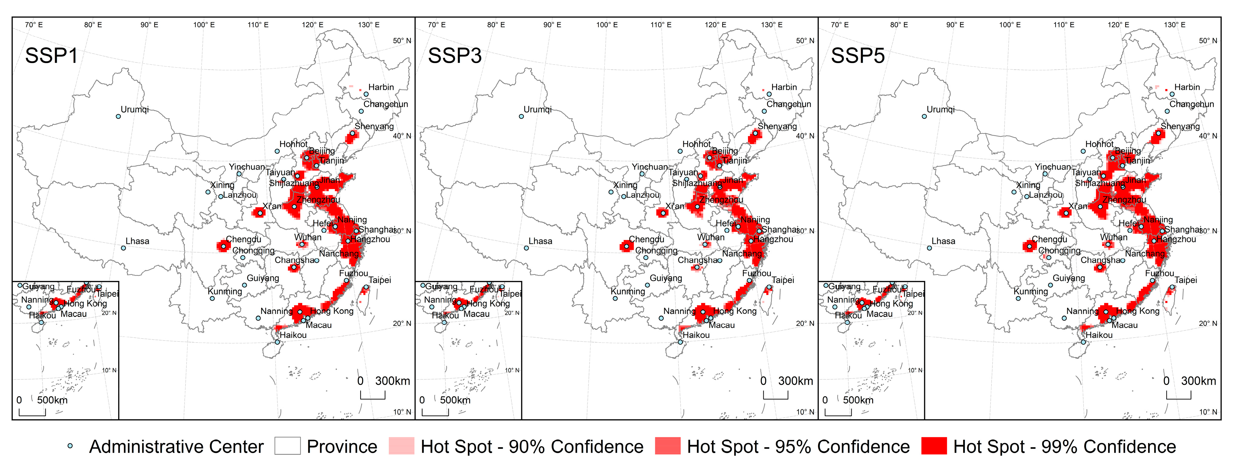
3.1. Urban Expansion from 2015 to 2050

Urban areas in China are expected to expand by 20–37% from 2015 to 2050. At the national scale, it is evident that the growth of urban land will be the least under the SSP3 scenario, which is 21.1 thousand km2. This can be attributed to the more restrictive development policies and slower population growth assumed in this scenario. Under SSP5, the growth is the highest, reaching 38.1 thousand km2 (Figure 3a). Spatially, the proportion of urban expansion showed a decreasing trend from coastal provinces to inland provinces.
Taking a 25 × 25 km grid as the basic unit, we identified statistically significant spatial hotspots of urban expansion using the Optimized Hotspot Analysis (Figure 4). The Beijing–Tianjin–Hebei urban agglomeration, the Yangtze River Delta urban agglomeration, and the Pearl River Delta urban agglomeration remain hotspots for future urban expansion (Figure 3b–e). In addition, the areas on both sides of the Taiwan Strait, including Taipei, Taoyuan, and Tainan in Taiwan Province, as well as the Guangdong–Fujian–Zhejiang coastal urban agglomeration, will also be hotspots for urban expansion in China in the future. There are also small-sized hotspots of urban expansion around the administrative centers in the central and western provinces.
Under different SSP scenarios, the proportion of land types occupied by future urban expansion in China may be similar (Figure 3a). Overall, cropland accounts for the largest proportion of up to 81% in each scenario, indicating that urban expansion is expected to have the most significant impact on artificial ecosystems. This is mainly because croplands are often located in relatively flat and accessible areas, which are prime locations for urban development [46]. In contrast, about 19% of urban expansion will be at the expense of natural habitats. Among them, forests may suffer the greatest loss. From 2015 to 2050, the area of forest loss caused by urban expansion will range from 1.9 to 3.5 thousand km2. Grasslands are predicted to decrease by 1.3 to 2.2 thousand km2. Additionally, water and wetlands are projected to decline by 0.8 to 1.3 thousand km2.

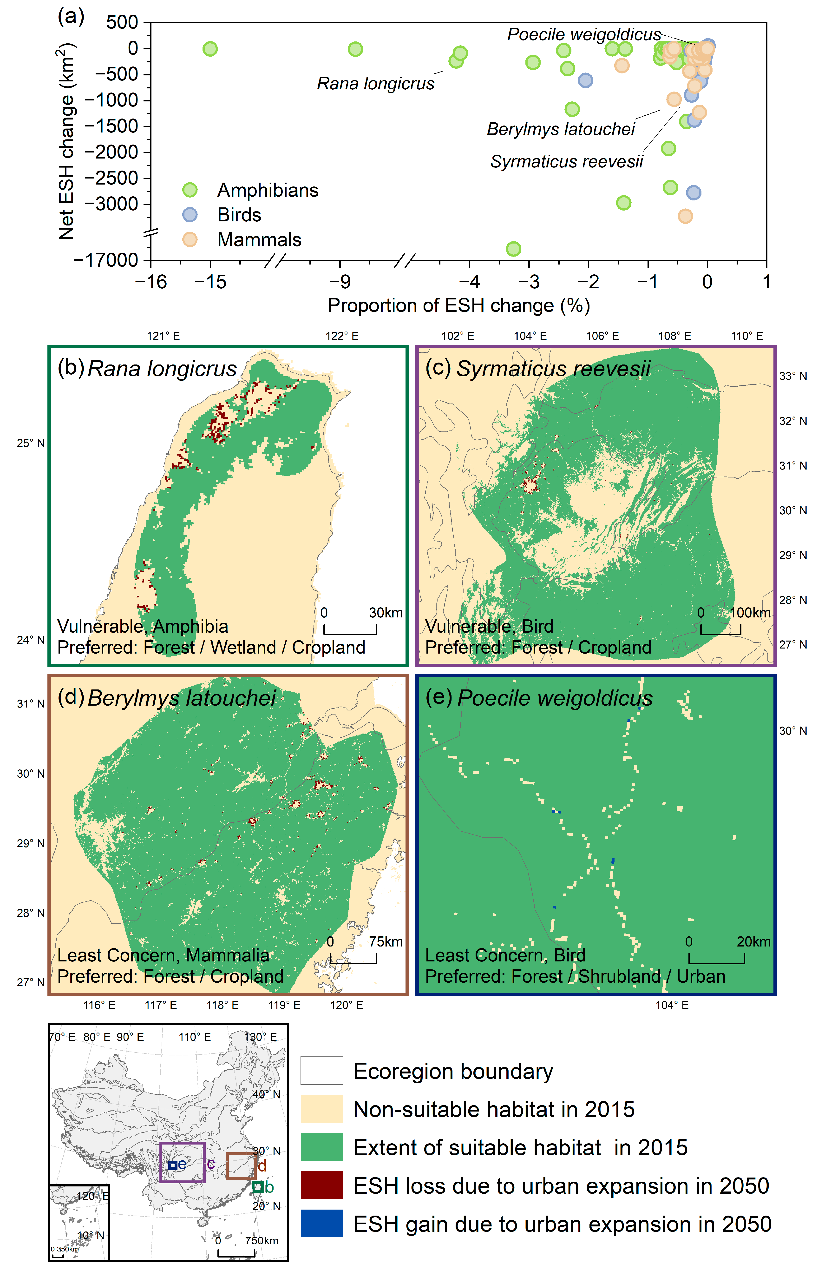
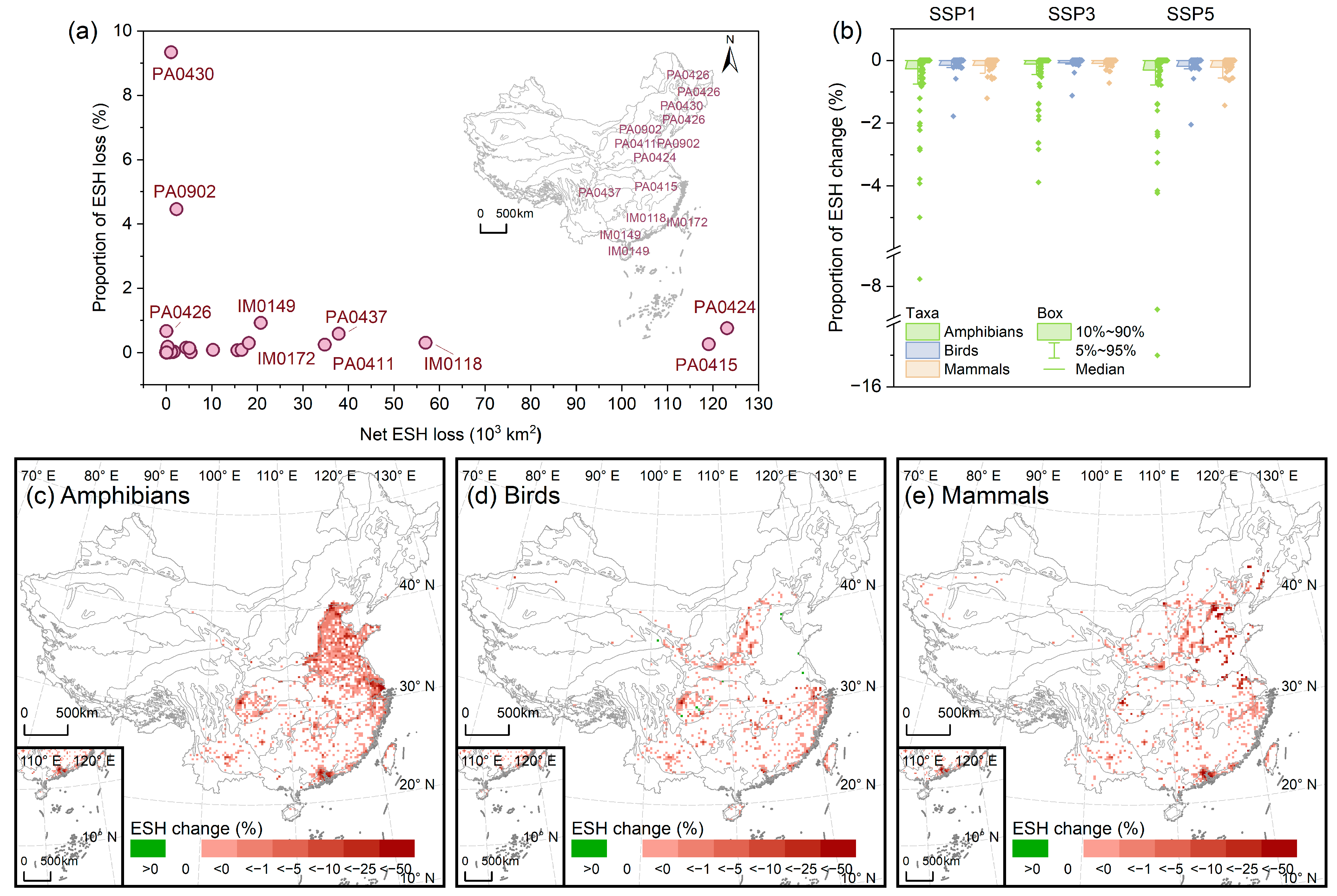
3.2. Impact of Urban Expansion on ESH

From 2015 to 2050, under the SSP1 and SSP5 scenarios, 37% of the assessed endemic species in China are projected to experience a loss in their extent of suitable habitat due to urban expansion. Under SSP3, this proportion is predicted to be 33%. For most endemic species, the projected impact of urban expansion on ESH is less than 1%. Under the SSP5 scenario, only 14 endemic species are projected to lose more than 1% of their ESH (Figure 5a). For SSP1 and SSP3, this number may be 13 and 10, respectively, accounting for only 2–3% of all the evaluated endemic species. Figure 5b–d highlight species with significant relative or net ESH losses across three taxa. By 2050, the Taipa frog (Rana longicrus) is predicted to lose 4.2% of its ESH under SSP5, with a net loss of 238 km2. Reeves’s pheasant (Syrmaticus reevesii), distributed in southwest China, is estimated to suffer an ESH loss of 892 km2, accounting for just 0.27%. Some endemic species that can adapt to urban environments are predicted to show an increase in ESH due to urban expansion. These species are few in number and exclusively birds, including the Sichuan tit (Poecile weigoldicus, under all three SSP scenarios; see Figure 5e), the silver-throated bushtit (Aegithalos glaucogularis, under all three SSP scenarios) and Styan’s bulbul (Pycnonotus taivanus, under SSP1 and SSP3).
Overall, from 2015 to 2050, urban expansion in China is projected to cause a loss of 0.072% (under SSP3) to 0.169% (under SSP5) of the extent of suitable habitats for all national-level endemic species. At the ecoregion scale, large coastal areas such as the Huang He Plain mixed forests (PA0424), the Changjiang Plain evergreen forests (PA0415), and the Jian Nan subtropical evergreen forests (IM0118) will suffer the most severe net losses of ESH (Figure 6a). The Sichuan Basin evergreen broadleaf forests (PA0437) and Taiwan subtropical evergreen forests (IM0172), located in the regions with the highest richness of endemic species in China, exhibit quite significant net losses of ESH despite their small areas. The top three ecoregions with the highest proportional losses of ESH are the Northeast China Plain deciduous forests (PA0430), the Bohai Sea saline meadow (PA0902), and the South China–Vietnam subtropical evergreen forests (IM0149), all of which are also located in coastal areas.
From the perspective of ESH loss, amphibian endemic species have been identified as being sensitive to urban expansion, with a projected ESH loss of 0.103–0.251% (Figure 6b). Taking the SSP5 scenario as an example (Figure 6c), the predicted hotspots of ESH loss for amphibian endemic species include the Beijing–Tianjin–Hebei urban agglomeration, the Yangtze River Delta urban agglomeration, the Pearl River Delta urban agglomeration, and the Chengdu–Chongqing urban agglomeration. Since birds generally have a relatively broad distribution range, they are expected to experience the least relative loss of the ESH. It is predicted that from 2015 to 2050, urban expansion will lead to an ESH loss of 0.031–0.060% for endemic birds. For birds, the regions with prominent ESH loss may be the Chengdu–Chongqing urban agglomeration (Figure 6d). Moreover, from 2015 to 2050, the loss of the ESH for endemic mammals is projected to be between 0.034% and 0.072%. The hotspot areas of ESH loss for endemic mammals include the Beijing–Tianjin–Hebei urban agglomeration and the Pearl River Delta urban agglomeration (Figure 6e).

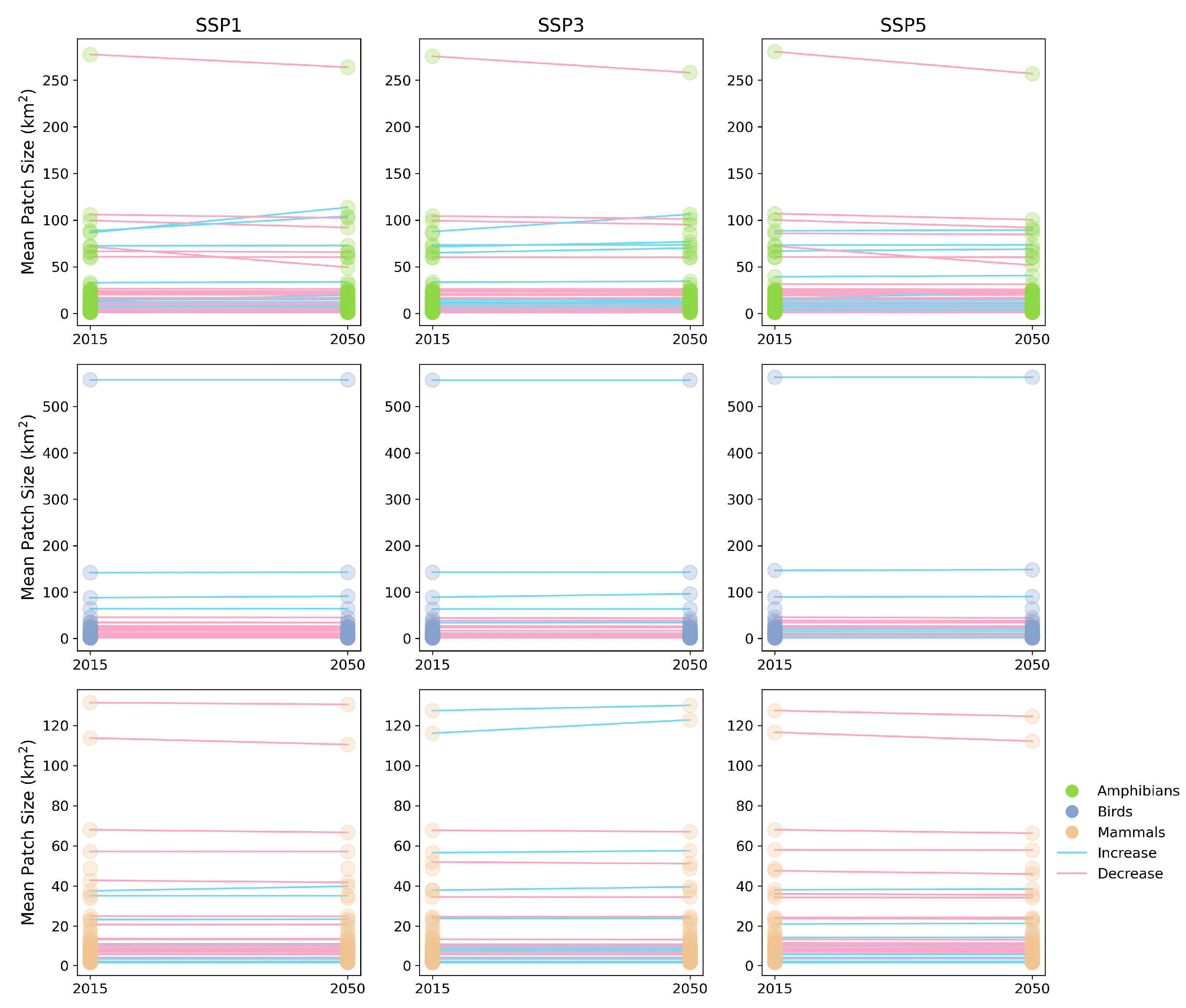
3.3. Impact of Urban Expansion on ESH Fragmentation

At the species level, we calculated the landscape indices of the suitable habitat range within a 5 km buffer zone of urban land in 2015 and 2050, including the mean patch size (MPS), edge density (ED), and the mean Euclidean nearest neighbor distance (ENN_MN).
The decrease in the MPS is often indicative of an increase in habitat fragmentation. Our findings suggest that under SSP1, 25% of the assessed national-level endemic species may face a decrease in MPS (Figure 7). This proportion is the highest among all three SSP scenarios. In contrast, under SSP3, only 19% of endemic species are expected to experience such a reduction. Endemic birds seem to be more vulnerable to habitat fragmentation. Under SSP1, 39% of endemic birds are projected to experience a reduction in the MPS of their ESH. Comparatively, only 19% of amphibians and 26% of mammals are predicted to face similar decreases. In some cases, fragmented patches are more easily disturbed by external factors [9]. During urban expansion, such patches tend to be occupied, resulting in the consolidation of remaining habitats and an increase in the MPS. However, the number of endemic species facing MPS increase is only 51–76% of that facing MPS reduction. The growth of the MPS may be most significant under the SSP3 scenario. Specifically, 14% of all endemic species, including 21% of mammals, 16% of birds, and 11% of amphibians, will experience an increase in the MPS of their ESH.
The increase in ED often implies the intensification of edge effects, which poses more challenges to the stability of the ecosystem [47]. Under SSP5, it is forecast that the ED of the ESH for 27% of the endemic species will increase (Figure 8). This proportion is the highest among all three SSP scenarios. Under both the SSP1 and SSP3 scenarios, 22% of the species will face the problem of an increase in ED. For different taxa, the growth of the ED of the ESH for birds and mammals is expected to be more serious. Taking the SSP5 scenario as an example, 34% of both birds and mammals will experience an increase in the ED of their ESH, while only 22% of amphibians will have such an increase. Similarly, there exist cases in which the ED of the endemic species’ ESH declines because of urban expansion, but the number of such species represents 36–70% of those facing an ED increase. Under SSP1, 16% of the endemic species’ ESH will experience an increase in their ED. While under both the SSP3 and SSP5 scenarios, this proportion may be approximately 10%.
The increase in the ENN_MN often implies the separation of habitats, which poses more threats to the connectivity of the ecological network [48,49]. Under the SSP5 scenario, the degree of habitat isolation for 24% of the endemic species will be enhanced (Figure 9). This proportion will be 23% and 22% under the SSP1 and SSP3 scenarios, respectively. Compared with other taxa, mammals are more likely to face habitat isolation. Under SSP5, for 38% of mammals, the ENN_MN of their ESH will increase. In comparison, for birds, only 25% of their ESH will have the ENN_MN increased, and for amphibians, the proportion is 19%. The number of species whose ENN_MN of the ESH decreases, that is, when the degree of isolation reduces, is the largest under SSP1 (25%), followed by the SSP5 (13%) and SSP3 (11%) scenarios. This quantity accounts for 49–64% of that of species experiencing ENN_MN growth.
Overall, at the species level, urban expansion in China from 2015 to 2050 may either mitigate ESH fragmentation (i.e., increased MPS, decreased ED, or decreased ENN_MN) or exacerbate it (i.e., decreased MPS, increased ED, or increased ENN_MN). Under different SSP scenarios, 19–25% of assessed national-level endemic species’ ESH will experience MPS decline, 22–27% will face ED increase, and 22–24% will face ENN_MN increase. Considering that only less than 40% of national endemic species’ ESH is projected to be altered by urban expansion, in fact, more than 56% of the affected species suffer from exacerbated habitat fragmentation. The proportion of species with exacerbated habitat fragmentation is approximately 1.3 to 2.8 times that of species with mitigated habitat fragmentation. The negative impacts of urban expansion on habitat fragmentation are relatively more common.

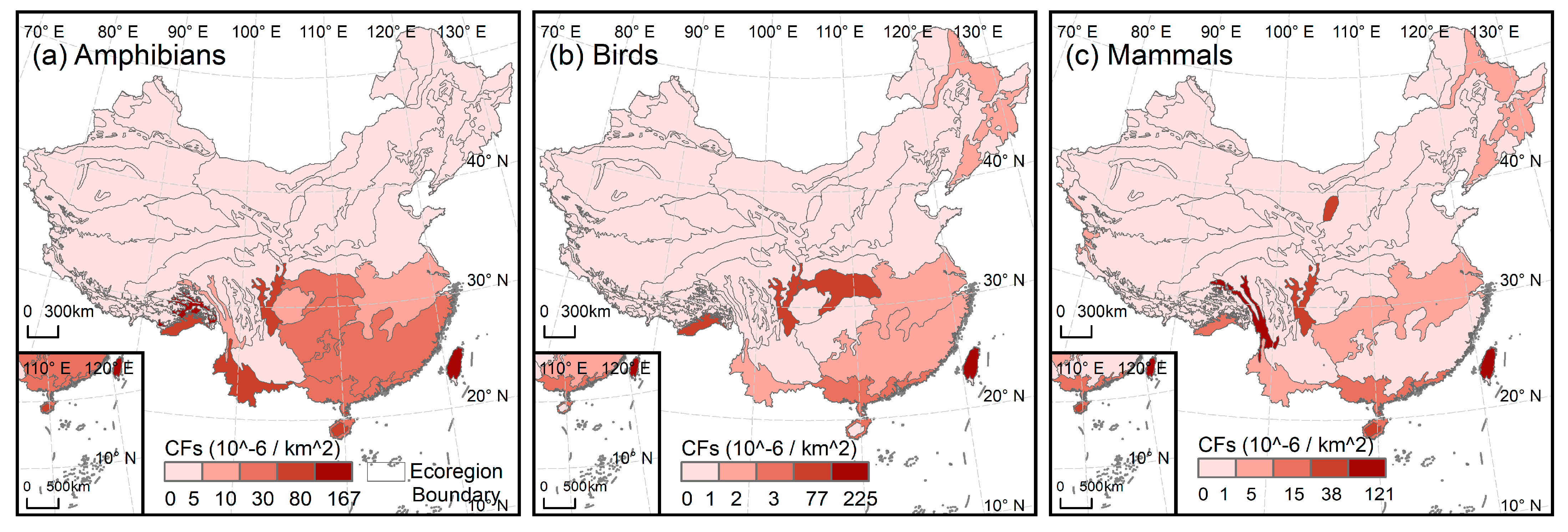
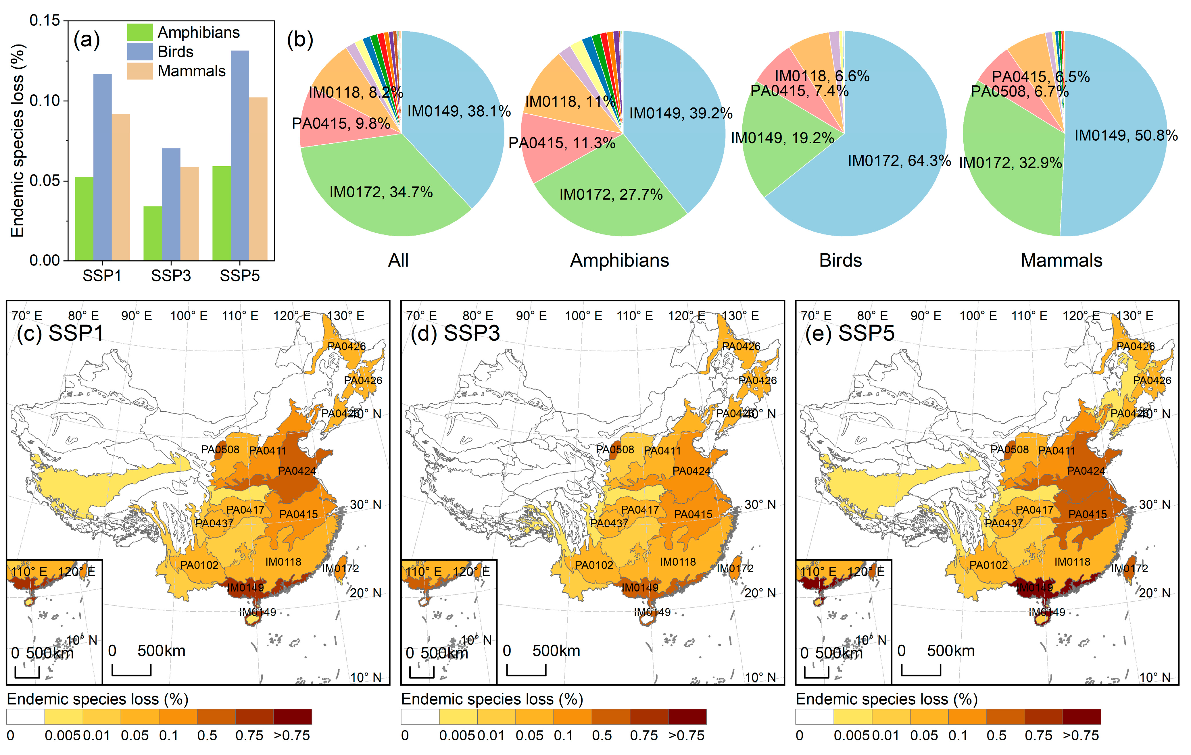
3.4. The Extinction Risk of Ecoregion-Level Endemic Species

Nationwide, newly added urban lands are projected to lead to extinction risk for 0.041 to 0.071% of ecoregion-level endemic species. From the perspective of species extinction risk, endemic birds are predicted to respond most sensitively to future urban expansion in China. From 2015 to 2050, the loss of endemic birds is projected to range from 0.070 to 0.131% (Figure 10a). It is noteworthy that under SSP5, the Taiwan subtropical evergreen forest (IM0172) region contributes 64.3% to the total national loss of endemic birds, highlighting the need for targeted conservation efforts in the region (Figure 10b). Following this, the loss of endemic mammals due to urban expansion is projected to range from 0.059 to 0.102% at the national scale. In addition, amphibian endemic species are projected to be the least affected by urban expansion among the three groups, with losses ranging from 0.034% to 0.059% (Figure 10a). Using the SSP5 scenario as an example, statistical results indicate that the South China–Vietnam subtropical evergreen forests (IM0149) and the Taiwan subtropical evergreen forests (IM0172) are projected to contribute the most to the total national loss of endemic amphibians and mammals.
At the ecoregion scale (Figure 10c–e), the South China–Vietnam subtropical evergreen forests (IM0149) will be the ecoregion with the highest proportion of endemic species facing extinction risk in the future. In this region, as high as 0.78% of endemic species will be at risk of extinction under the SSP5 scenario from 2015 to 2050. Furthermore, the Huang He Plain mixed forests (PA0424), the Changjiang Plain evergreen forests (PA0415), and the Taiwan subtropical evergreen forests (IM0172), which cover the hotspots of urban expansion, are likely to experience relatively high extinction risks for endemic species in the future. We also noted that, for the Helanshan montane conifer forests (PA0508), the proportion of endemic species loss under all three SSP scenarios is expected to exceed 0.1%. According to Figure 2c, the CF for endemic mammal losses in this region is high. Protecting endemic mammals within this region from the influences of urban expansion may be challenging.
Overall, the comparison between SSP scenarios indicates that, under the SSP5 scenario, rapid economic development along with substantial urban population growth is projected to result in urban expansion far greater than that in other scenarios. This is expected to cause the highest extinction risk for endemic species. The proportion of endemic species at risk of extinction is expected to reach 0.169% in total under SSP5. SSP1 ranks second, with the proportion of endemic species at risk of extinction being 0.095%. Under SSP3, the effect of urban expansion on endemic species richness is relatively minor, representing only 57% of the impact under SSP5. The comparison of spatial distributions also indicates that, under the SSP5 scenario, urban expansion causes the most extensive and intense loss of endemic species (Figure 10c–e).

4. Discussion

4.1. The Impact of Urban Expansion on Endemic Species

From 2015 to 2050, China’s urban area is predicted to increase by 21.1 to 38.1 thousand km2. This expansion is estimated to represent about 0.22–0.40% of the country’s total land area. At the national scale, newly added urban lands are projected to cause 0.072–0.169% loss of suitable habitat for national-level endemic species and expose 0.041–0.071% of ecoregion-level endemic species to extinction risk. The results, based on these two indicators, both show that the proportion of biodiversity loss is smaller than the proportion of urban expansion. This may be attributed to the inconsistency between China’s future urban expansion hotspots and biodiversity distribution hotspots. Urban expansion in China is mainly concentrated in plains and coastal areas with dense population and favorable economic development conditions. However, the distribution of endemic species is limited, being concentrated in specific mountainous areas, islands, and other unique ecological regions. Another possible reason is that future urban expansion in China will be more at the cost of the loss of simple cropland ecosystems rather than natural ecosystems such as forests and wetlands with higher biodiversity levels.
However, despite the seemingly lower proportion of biodiversity loss compared to urban expansion, our findings suggest that urban expansion is likely to affect endemic species more significantly than non-endemic species. Based on the biodiversity intactness index (which characterizes the changes in plant and animal average abundance), the fraction of regionally remaining species, and the suitable habitats for terrestrial mammals, Li et al. [39] calculated the direct impact of urban expansion on biodiversity in China from 1980 to 2020. The study focused on all species, including endemic species as well as other more widely spread species. Based on the average values of the three biodiversity indicators, they found that the urban expansion of 71.2 thousand km2 led to a direct loss of 0.163% in biodiversity. By contrast, the averages of the two indicators in our paper indicate that the newly expanded urban land, ranging from 21.1 thousand to 38.1 thousand km2, can cause a biodiversity loss of 0.056–0.120%. Except for the SSP3 scenario, the impact of urban expansion on endemic species seems to be more intense than that on other, more widely distributed species.
Besides suitable habitat loss and extinction risk, our findings indicate that habitat fragmentation caused by future urban expansion in China may also demand attention. For more than 56% of the affected species, their suitable habitats will suffer from a decrease in the MPS, an increase in the ED, or an increase in the ENN_MN. A decrease in the MPS constricts living space for species, and as patches become smaller, they are more prone to edge effects [50]. An increase in the ED also enhances the edge effect. The altered edge environment leads to resource competition, driving some species to extinction [51]. An increase in the ENN_MN leads to more pronounced habitat isolation. This impedes species movement, weakens ecosystem resilience, and makes the ecosystem more fragile [49]. Moreover, a great number of endemic species may even suffer multiple fragmentation impacts simultaneously, which are interwoven in complex ways and operate over potentially long time scales [52]. Hence, during the process of urban planning, the ecological protection of redline regions should be demarcated to make sure that significant habitats and ecological corridors are rigorously protected, avoiding the damage caused by uncontrolled urban expansion [53,54].

4.2. Implications for Management and Protection

The findings of our study regarding the impact of urban expansion on endemic species in China might offer some implications for management and protection strategies. Firstly, results from various biodiversity assessment methods show that there are differences in the species categories identified as most vulnerable to urban expansion, emphasizing the critical role of multi-method approaches in biodiversity evaluations. Birds, being highly mobile taxa, depend on extensive and connected habitats. Thus, assessments of habitat fragmentation and extinction risk indicate that endemic birds are projected to face higher risks of biodiversity loss due to future urban expansion in China. To mitigate this, policies should focus on creating and maintaining bird corridors that connect fragmented habitats [53]. Additionally, urban planning should incorporate the protection of large urban parks [55]. In areas where urban development is inevitable, developers should add bird-friendly features such as green roofs and nesting boxes in buildings to provide alternative habitats [56]. Moreover, evaluations of suitable habitat changes show that endemic amphibians are expected to face significant losses in ESH. Many amphibians have higher requirements for habitat quality, relying on specific microhabitats with moisture, temperature, pH, sufficient refuges, and food. Even minor habitat changes can easily disrupt these conditions [57,58]. To address this, small reserves should be established to complement existing protected area networks [59]. In addition, it is necessary to prioritize wetland protection and restoration. In addition to preventing the conversion of wetlands for urban purposes, water pollution generated during the urban metabolic process should also be avoided [60]. Besides the taxa that are in urgent need of focused protection, our results have also helped to identify the key protection areas. Findings from both assessments of species suitable habitat dynamics and extinction risk reveal that regions with high endemic species richness, such as Sichuan and Taiwan, as well as future rapidly urbanizing agglomerations, such as the Pearl River Delta, the Yangtze River Delta, and the Guangdong–Fujian–Zhejiang region, are projected to experience significant biodiversity loss. Strict land use regulations should be established in these regions, and compact urban growth should be facilitated [9]. Meanwhile, comprehensive nature-based solutions should be implemented. For example, measures including the conservation and restoration of urban water systems and the establishment of human-made green spaces can be implemented to enhance the resilience of ecosystems [61].
Furthermore, our analysis based on the SSP scenarios shows that under SSP5, the scenario with the most rapid economic growth and a substantial urban population increase, the land policies seem to prioritize development, resulting in extensive urban expansion [27]. This leads to the most severe loss of endemic species and their habitats. In contrast, SSP3 has more restrictive development policies, which curtail urban growth to a certain extent [26]. However, it is essential to note that the relatively minor impact on biodiversity under SSP3 might come at the cost of economic development. Therefore, the trade-off between urban development and biodiversity conservation requires further consideration. This challenge is not unique to China but represents a common dilemma in global urbanization processes, particularly in developing countries with rapid urbanization in regions such as sub-Saharan Africa, South America, Western Asia, and Southeast Asia [9,17]. For example, compared with rural areas, urban development has led to a decrease in the abundance and richness of small mammals in the fragmented shrublands of the Mediterranean ecological region in Chile and has led to the lack of endemic species, suggesting that habitat fragments isolated by urbanization are not sufficient to maintain native small-mammal populations [62]. Moreover, in Palmas, Brazil, the destruction of forests caused by urban development has diminished the possibility of the presence of Penelope ochrogaster, a Cerrado endemic species that was previously observed in the region [63]. As another case, human settlements have reduced habitat connectivity for Equus grevyi (endemic to Kenya and Ethiopia) in savanna ecosystems, resulting in increased population fragmentation and extinction risk [64]. Therefore, for China and other nations facing similar challenges, selecting appropriate development pathways is pivotal to balancing urban expansion and biodiversity conservation. In addition, it is necessary to integrate international policy frameworks with localization strategies. The Kunming-Montreal Global Biodiversity Framework sets the “30 × 30 target”, aiming to protect at least 30% of the global land and ocean by 2030. China’s Ecological Conservation Redline (ECR) policy aligns well with this, as its core goal is to designate inviolable ecological protection zones to safeguard biodiversity and restrict unchecked urban expansion [65]. Additionally, adopting nature-based solutions, such as the Sponge City initiative, can reconcile urban growth with the framework’s conservation objectives, ensuring development does not exceed ecological thresholds. These policies should continue to be advanced in the future to protect endemic species from the threats of urban expansion, ensuring that conservation efforts keep pace with developmental demands.

4.3. Limitations and Future Perspectives

This paper has some limitations. Firstly, our analysis focused mainly on the direct impacts of urban expansion on endemic species. However, we did not consider the indirect effects of urban expansion, for instance, the indirect impacts through cropland displacement [39], through trampling and disruptions [34], through pollutants [60], and through urban consumption [66]. These indirect effects may far exceed the direct effects both in terms of degree and range.
Secondly, we did not eliminate the disturbance caused by climate change. On the one hand, urban expansion will accelerate the changes in regional microclimate, leading to effects such as the urban heat island, which will have an impact on the distribution of species. On the other hand, climate change will also affect urban development and the transformation of land use types. Therefore, future research needs to pay more attention to the transformation of urban land and other land types driven by climate and attempt to isolate the climate factors.
Thirdly, there are some limitations in the biodiversity assessment methods we used. When analyzing species’ ESH changes, we binarized habitat suitability for each species without accounting for their differential adaptive responses to habitat variations. Moreover, the cSAR model provides a simple and easy-to-apply method for predicting species extinction, but it also has limitations such as overlooking the effects of the geometry of area loss [67] and the absence of uncertainty assessment for input data during parameterization [41].
Finally, according to the prediction, for some SSP scenarios, the demand for urban land in China may start to decrease in the 2040s. However, instead of simulating urban shrinkage, Chen et al. [28] assumed that the quantity and distribution of urban land remained the same as those in the previous period. In future research, urban shrinkage needs to be taken into consideration because urban rewilding can mitigate the impacts of urban development on biodiversity [68].

5. Conclusions

Our research illustrates the impacts of future urban expansion in China from 2015 to 2050 under the SSP framework on endemic species from multiple perspectives, including loss of suitable habitats, habitat fragmentation, and extinction risk. The results show that from the perspective of suitable habitat loss and extinction risk, the negative impact of urban expansion in China from 2015 to 2050 may be greater for endemic species than for other species with a wide distribution. In addition, more than 56% of the affected species suffer from exacerbated habitat fragmentation. Our findings show that biodiversity loss is more serious in regions with high endemic species richness and in urban agglomerations with rapid urban development in the future. Endemic amphibians and birds show their high sensitivity to the threats of urban expansion from various perspectives. Special attention should be paid to the above-mentioned regions and taxa. As a developing country with significant biodiversity, China will be challenged to protect endemic species from urban expansion in the future. It is essential to integrate international policy frameworks with localization strategies and coordinate urban development with biodiversity conservation.

Author Contributions

Conceptualization, K.L. and X.L.; methodology, K.L.; software, K.L.; validation, K.L.; formal analysis, K.L.; data curation, K.L.; writing—original draft preparation, K.L.; writing—review and editing, X.W. and X.L.; visualization, K.L.; supervision, X.L.; project administration, X.W. and X.L.; funding acquisition, X.L. All authors have read and agreed to the published version of the manuscript.

Funding

This work is funded by the National Science Fund for Distinguished Young Scholars (Grant No. 42225107) and the National Key Research and Development Program of China (Grant No. 2022YFB3903402 and No. 2019YFA0607203).

Data Availability Statement

The future urban land projection products can be downloaded at http://www.geosimulation.cn/GlobalSSPsUrbanProduct.html (accessed on 19 July 2023). The ESA CCI-LC product is available from http://maps.elie.ucl.ac.be/CCI/viewer/download.php (accessed on 8 September 2021). The geographical range, habitat preference, and elevation preference of species can be obtained from https://www.iucnredlist.org (accessed on 10 February 2025). Elevation data are available from https://worldclim.org/data/worldclim21.html (accessed on 23 April 2023). Terrestrial Ecoregions of the World can be obtained at https://www.worldwildlife.org/publications/terrestrial-ecoregions-of-the-world (accessed on 16 October 2024).

Conflicts of Interest

The authors declare no conflicts of interest.

References

  1. Zhang, S.; Zhou, Y.; Yu, R.; Xu, X.; Xu, M.; Li, G.; Wang, W.; Yang, Y. China’s biodiversity conservation in the process of implementing the sustainable development goals (SDGs). J. Clean. Prod. 2022, 338, 130595. [Google Scholar] [CrossRef]
  2. Pereira, H.M.; Martins, I.S.; Rosa, I.M.D.; Kim, H.; Leadley, P.; Popp, A.; van Vuuren, D.P.; Hurtt, G.; Quoss, L.; Arneth, A.; et al. Global trends and scenarios for terrestrial biodiversity and ecosystem services from 1900 to 2050. Science 2024, 384, 458–465. [Google Scholar] [CrossRef]
  3. IPBES. Global Assessment Report of the Intergovernmental Science-Policy Platform on Biodiversity and Ecosystem Services; Intergovernmental Science-Policy Platform on Biodiversity and Ecosystem Services: Bonn, Germany, 2019. [Google Scholar]
  4. Tittensor, D.P.; Walpole, M.; Hill, S.L.L.; Boyce, D.G.; Britten, G.L.; Burgess, N.D.; Butchart, S.H.M.; Leadley, P.W.; Regan, E.C.; Alkemade, R.; et al. A mid-term analysis of progress toward international biodiversity targets. Science 2014, 346, 241–244. [Google Scholar] [CrossRef]
  5. Marques, A.; Martins, I.S.; Kastner, T.; Plutzar, C.; Theurl, M.C.; Eisenmenger, N.; Huijbregts, M.A.J.; Wood, R.; Stadler, K.; Bruckner, M.; et al. Increasing impacts of land use on biodiversity and carbon sequestration driven by population and economic growth. Nat. Ecol. Evol. 2019, 3, 628–637. [Google Scholar] [CrossRef]
  6. McKinney, M.L. Urbanization, Biodiversity, and Conservation: The impacts of urbanization on native species are poorly studied, but educating a highly urbanized human population about these impacts can greatly improve species conservation in all ecosystems. BioScience 2002, 52, 883–890. [Google Scholar] [CrossRef]
  7. Pimm, S.L.; Jenkins, C.N.; Abell, R.; Brooks, T.M.; Gittleman, J.L.; Joppa, L.N.; Raven, P.H.; Roberts, C.M.; Sexton, J.O. The biodiversity of species and their rates of extinction, distribution, and protection. Science 2014, 344, 1246752. [Google Scholar] [CrossRef]
  8. Simkin, R.D.; Seto, K.C.; McDonald, R.I.; Jetz, W. Biodiversity impacts and conservation implications of urban land expansion projected to 2050. Proc. Natl. Acad. Sci. USA 2022, 119, e2117297119. [Google Scholar] [CrossRef] [PubMed]
  9. Li, G.; Fang, C.; Li, Y.; Wang, Z.; Sun, S.; He, S.; Qi, W.; Bao, C.; Ma, H.; Fan, Y.; et al. Global impacts of future urban expansion on terrestrial vertebrate diversity. Nat. Commun. 2022, 13, 1628. [Google Scholar] [CrossRef]
  10. Xu, J.; Ling, Y.; Sun, Y.; Jiang, Y.; Shen, R.; Wang, Y. How do different processes of habitat fragmentation affect habitat quality?—Evidence from China. Ecol. Indic. 2024, 160, 111880. [Google Scholar] [CrossRef]
  11. Zhou, W.; Zhang, S.; Yu, W.; Wang, J.; Wang, W. Effects of Urban Expansion on Forest Loss and Fragmentation in Six Megaregions, China. Remote Sens. 2017, 9, 991. [Google Scholar] [CrossRef]
  12. Ren, Q.; He, C.; Huang, Q.; Zhang, D.; Shi, P.; Lu, W. Impacts of global urban expansion on natural habitats undermine the 2050 vision for biodiversity. Resour. Conserv. Recycl. 2023, 190, 106834. [Google Scholar] [CrossRef]
  13. Wurz, A.; Grass, I.; Lees, D.C.; Rakotomalala, A.A.N.A.; Sáfián, S.; Martin, D.A.; Osen, K.; Loos, J.; Benasoavina, E.; Alexis, T.; et al. Land-use change differentially affects endemic, forest and open-land butterflies in Madagascar. Insect Conserv. Divers. 2022, 15, 606–620. [Google Scholar] [CrossRef]
  14. McDonald, R.I.; Güneralp, B.; Huang, C.-W.; Seto, K.C.; You, M. Conservation priorities to protect vertebrate endemics from global urban expansion. Biol. Conserv. 2018, 224, 290–299. [Google Scholar] [CrossRef]
  15. Myers, N.; Mittermeier, R.A.; Mittermeier, C.G.; da Fonseca, G.A.B.; Kent, J. Biodiversity hotspots for conservation priorities. Nature 2000, 403, 853–858. [Google Scholar] [CrossRef] [PubMed]
  16. Seto, K.C.; Güneralp, B.; Hutyra, L.R. Global forecasts of urban expansion to 2030 and direct impacts on biodiversity and carbon pools. Proc. Natl. Acad. Sci. USA 2012, 109, 16083–16088. [Google Scholar] [CrossRef] [PubMed]
  17. Güneralp, B.; Seto, K.C. Futures of global urban expansion: Uncertainties and implications for biodiversity conservation. Environ. Res. Lett. 2013, 8, 014025. [Google Scholar] [CrossRef]
  18. Walters, G.; Ngagnia Ndjabounda, E.; Ikabanga, D.; Biteau, J.P.; Hymas, O.; White, L.J.T.; Ndong Obiang, A.M.; Ndong Ondo, P.; Jeffery, K.J.; Lachenaud, O.; et al. Peri-urban conservation in the Mondah forest of Libreville, Gabon: Red List assessments of endemic plant species, and avoiding protected area downsizing. Oryx 2016, 50, 419–430. [Google Scholar] [CrossRef]
  19. Sanz, V.; Caula, S. Assessing bird assemblages along an urban gradient in a Caribbean island (Margarita, Venezuela). Urban Ecosyst. 2015, 18, 729–746. [Google Scholar] [CrossRef]
  20. Bai, X.; Shi, P.; Liu, Y. Society: Realizing China’s urban dream. Nature 2014, 509, 158–160. [Google Scholar] [CrossRef]
  21. Hu, Y.n.; Connor, D.S.; Stuhlmacher, M.; Peng, J.; Turner Ii, B.L. More urbanization, more polarization: Evidence from two decades of urban expansion in China. npj Urban Sustain. 2024, 4, 33. [Google Scholar] [CrossRef]
  22. Li, X.; Chen, Y. Projecting the future impacts of China’s cropland balance policy on ecosystem services under the shared socioeconomic pathways. J. Clean. Prod. 2020, 250, 119489. [Google Scholar] [CrossRef]
  23. Ministry of Ecology and Environment of the People’s Republic of China; Chinese Academy of Sciences. China’s Red List of Biodiversity: Vertebrates. Biodivers. Sci. 2015, 24, 500–551. [Google Scholar]
  24. O’Neill, B.C.; Kriegler, E.; Ebi, K.L.; Kemp-Benedict, E.; Riahi, K.; Rothman, D.S.; van Ruijven, B.J.; van Vuuren, D.P.; Birkmann, J.; Kok, K.; et al. The roads ahead: Narratives for shared socioeconomic pathways describing world futures in the 21st century. Glob. Environ. Change 2017, 42, 169–180. [Google Scholar] [CrossRef]
  25. van Vuuren, D.P.; Stehfest, E.; Gernaat, D.E.H.J.; Doelman, J.C.; van den Berg, M.; Harmsen, M.; de Boer, H.S.; Bouwman, L.F.; Daioglou, V.; Edelenbosch, O.Y.; et al. Energy, land-use and greenhouse gas emissions trajectories under a green growth paradigm. Glob. Environ. Change 2017, 42, 237–250. [Google Scholar] [CrossRef]
  26. Fujimori, S.; Hasegawa, T.; Masui, T.; Takahashi, K.; Herran, D.S.; Dai, H.; Hijioka, Y.; Kainuma, M. SSP3: AIM implementation of Shared Socioeconomic Pathways. Glob. Environ. Change 2017, 42, 268–283. [Google Scholar] [CrossRef]
  27. Kriegler, E.; Bauer, N.; Popp, A.; Humpenöder, F.; Leimbach, M.; Strefler, J.; Baumstark, L.; Bodirsky, B.L.; Hilaire, J.; Klein, D.; et al. Fossil-fueled development (SSP5): An energy and resource intensive scenario for the 21st century. Glob. Environ. Change 2017, 42, 297–315. [Google Scholar] [CrossRef]
  28. Chen, G.; Li, X.; Liu, X.; Chen, Y.; Liang, X.; Leng, J.; Xu, X.; Liao, W.; Qiu, Y.; Wu, Q.; et al. Global projections of future urban land expansion under shared socioeconomic pathways. Nat. Commun. 2020, 11, 537. [Google Scholar] [CrossRef]
  29. Pesaresi, M.; Huadong, G.; Blaes, X.; Ehrlich, D.; Ferri, S.; Gueguen, L.; Halkia, M.; Kauffmann, M.; Kemper, T.; Lu, L.; et al. A Global Human Settlement Layer From Optical HR/VHR RS Data: Concept and First Results. IEEE J. Sel. Top. Appl. Earth Obs. Remote Sens. 2013, 6, 2102–2131. [Google Scholar] [CrossRef]
  30. Liu, X.; Liang, X.; Li, X.; Xu, X.; Ou, J.; Chen, Y.; Li, S.; Wang, S.; Pei, F. A future land use simulation model (FLUS) for simulating multiple land use scenarios by coupling human and natural effects. Landsc. Urban Plan. 2017, 168, 94–116. [Google Scholar] [CrossRef]
  31. Pontius, R.G.; Boersma, W.; Castella, J.C.; Clarke, K.; de Nijs, T.; Dietzel, C.; Duan, Z.; Fotsing, E.; Goldstein, N.; Kok, K.; et al. Comparing the input, output, and validation maps for several models of land change. Ann. Reg. Sci. 2008, 42, 11–37. [Google Scholar] [CrossRef]
  32. Li, X.; Chen, G.; Liu, X.; Liang, X.; Wang, S.; Chen, Y.; Pei, F.; Xu, X. A New Global Land-Use and Land-Cover Change Product at a 1-km Resolution for 2010 to 2100 Based on Human-Environment Interactions. Ann. Am. Assoc. Geogr. 2017, 107, 1040–1059. [Google Scholar] [CrossRef]
  33. Chen, Y.M.; Li, X.; Liu, X.P.; Ai, B. Modeling urban land-use dynamics in a fast developing city using the modified logistic cellular automaton with a patch-based simulation strategy. Int. J. Geogr. Inf. Sci. 2014, 28, 234–255. [Google Scholar] [CrossRef]
  34. Ren, Q.; He, C.; Huang, Q.; Shi, P.; Zhang, D.; Güneralp, B. Impacts of urban expansion on natural habitats in global drylands. Nat. Sustain. 2022, 5, 869–878. [Google Scholar] [CrossRef]
  35. Menéndez, R.; Megías, A.G.; Hill, J.K.; Braschler, B.; Willis, S.G.; Collingham, Y.; Fox, R.; Roy, D.B.; Thomas, C.D. Species richness changes lag behind climate change. Proc. R. Soc. B Biol. Sci. 2006, 273, 1465–1470. [Google Scholar] [CrossRef] [PubMed]
  36. He, J.; Gao, Z.; Su, Y.; Lin, S.; Jiang, H. Geographical and temporal origins of terrestrial vertebrates endemic to Taiwan. J. Biogeogr. 2018, 45, 2458–2470. [Google Scholar] [CrossRef]
  37. Qiao, L.; Wen, G.; Qi, Y.; Lu, B.; Hu, J.; Song, Z.; Fu, J. Evolutionary melting pots and reproductive isolation: A ring-shaped diversification of an odorous frog (Odorrana margaratea) around the Sichuan Basin. Mol. Ecol. 2018, 27, 4888–4900. [Google Scholar] [CrossRef]
  38. Powers, R.P.; Jetz, W. Global habitat loss and extinction risk of terrestrial vertebrates under future land-use-change scenarios. Nat. Clim. Change 2019, 9, 323–329. [Google Scholar] [CrossRef]
  39. Li, F.; Wu, S.; Liu, H.; Yan, D. Biodiversity loss through cropland displacement for urban expansion in China. Sci. Total. Environ. 2024, 907, 167988. [Google Scholar] [CrossRef]
  40. Halley, J.M.; Sgardeli, V.; Triantis, K.A. Extinction debt and the species–area relationship: A neutral perspective. Glob. Ecol. Biogeogr. 2014, 23, 113–123. [Google Scholar] [CrossRef]
  41. Chaudhary, A.; Brooks, T.M. National Consumption and Global Trade Impacts on Biodiversity. World Dev. 2019, 121, 178–187. [Google Scholar] [CrossRef]
  42. Proença, V.; Pereira, H.M. Species–area models to assess biodiversity change in multi-habitat landscapes: The importance of species habitat affinity. Basic Appl. Ecol. 2013, 14, 102–114. [Google Scholar] [CrossRef]
  43. Pereira, H.M.; Ziv, G.U.Y.; Miranda, M. Countryside Species—Area Relationship as a Valid Alternative to the Matrix—Calibrated Species—Area Model. Conserv. Biol. 2014, 28, 874–876. [Google Scholar] [CrossRef]
  44. Drakare, S.; Lennon, J.J.; Hillebrand, H. The imprint of the geographical, evolutionary and ecological context on species–area relationships. Ecol. Lett. 2006, 9, 215–227. [Google Scholar] [CrossRef] [PubMed]
  45. Leclère, D.; Obersteiner, M.; Barrett, M.; Butchart, S.H.M.; Chaudhary, A.; De Palma, A.; DeClerck, F.A.J.; Di Marco, M.; Doelman, J.C.; Dürauer, M.; et al. Bending the curve of terrestrial biodiversity needs an integrated strategy. Nature 2020, 585, 551–556. [Google Scholar] [CrossRef]
  46. Bren d’Amour, C.; Reitsma, F.; Baiocchi, G.; Barthel, S.; Guneralp, B.; Erb, K.H.; Haberl, H.; Creutzig, F.; Seto, K.C. Future urban land expansion and implications for global croplands. Proc. Natl. Acad. Sci. USA 2017, 114, 8939–8944. [Google Scholar] [CrossRef]
  47. Oliver, T.H.; Marshall, H.H.; Morecroft, M.D.; Brereton, T.; Prudhomme, C.; Huntingford, C. Interacting effects of climate change and habitat fragmentation on drought-sensitive butterflies. Nat. Clim. Change 2015, 5, 941–945. [Google Scholar] [CrossRef]
  48. Wang, X.; Cumming, S.G. Modeling configuration dynamics of harvested forest landscapes in the Canadian boreal plains. Landsc. Ecol. 2009, 24, 229–241. [Google Scholar] [CrossRef]
  49. Wang, X.; Blanchet, F.G.; Koper, N. Measuring habitat fragmentation: An evaluation of landscape pattern metrics. Methods Ecol. Evol. 2014, 5, 634–646. [Google Scholar] [CrossRef]
  50. Rogan, J.E.; Lacher, T.E. Impacts of Habitat Loss and Fragmentation on Terrestrial Biodiversity. In Reference Module in Earth Systems and Environmental Sciences; Elsevier: Amsterdam, The Netherlands, 2018. [Google Scholar]
  51. Willmer, J.N.G.; Püttker, T.; Prevedello, J.A. Global impacts of edge effects on species richness. Biol. Conserv. 2022, 272, 109654. [Google Scholar] [CrossRef]
  52. Haddad, N.M.; Brudvig, L.A.; Clobert, J.; Davies, K.F.; Gonzalez, A.; Holt, R.D.; Lovejoy, T.E.; Sexton, J.O.; Austin, M.P.; Collins, C.D.; et al. Habitat fragmentation and its lasting impact on Earth’s ecosystems. Sci. Adv. 2015, 1, e1500052. [Google Scholar] [CrossRef]
  53. Chen, R.; Carruthers-Jones, J.; Carver, S.; Wu, J. Constructing urban ecological corridors to reflect local species diversity and conservation objectives. Sci. Total Environ. 2024, 907, 167987. [Google Scholar] [CrossRef] [PubMed]
  54. Tambosi, L.R.; Martensen, A.C.; Ribeiro, M.C.; Metzger, J.P. A Framework to Optimize Biodiversity Restoration Efforts Based on Habitat Amount and Landscape Connectivity. Restor. Ecol. 2014, 22, 169–177. [Google Scholar] [CrossRef]
  55. Yang, X.; Tan, X.; Chen, C.; Wang, Y. The influence of urban park characteristics on bird diversity in Nanjing, China. Avian Res. 2020, 11, 45. [Google Scholar] [CrossRef]
  56. Chiquet, C.; Dover, J.W.; Mitchell, P. Birds and the urban environment: The value of green walls. Urban Ecosyst. 2013, 16, 453–462. [Google Scholar] [CrossRef]
  57. Luedtke, J.A.; Chanson, J.; Neam, K.; Hobin, L.; Maciel, A.O.; Catenazzi, A.; Borzée, A.; Hamidy, A.; Aowphol, A.; Jean, A.; et al. Ongoing declines for the world’s amphibians in the face of emerging threats. Nature 2023, 622, 308–314. [Google Scholar] [CrossRef]
  58. Purvis, A.; Agapow, P.-M.; Gittleman, J.L.; Mace, G.M. Nonrandom Extinction and the Loss of Evolutionary History. Science 2000, 288, 328–330. [Google Scholar] [CrossRef]
  59. Rodrigues, A.S.L.; Andelman, S.J.; Bakarr, M.I.; Boitani, L.; Brooks, T.M.; Cowling, R.M.; Fishpool, L.D.C.; da Fonseca, G.A.B.; Gaston, K.J.; Hoffmann, M.; et al. Effectiveness of the global protected area network in representing species diversity. Nature 2004, 428, 640–643. [Google Scholar] [CrossRef]
  60. McDonald, R.I.; Mansur, A.V.; Ascensão, F.; Colbert, M.l.; Crossman, K.; Elmqvist, T.; Gonzalez, A.; Güneralp, B.; Haase, D.; Hamann, M.; et al. Research gaps in knowledge of the impact of urban growth on biodiversity. Nat. Sustain. 2019, 3, 16–24. [Google Scholar] [CrossRef]
  61. Zecheng, W.; Xinsheng, Z.; Lijuan, C.; Yinru, L.; Ziliang, G.; Jinzhi, W.; Jing, L.; Xiajie, Z.; Rumiao, W.; Wei, L. Identification and optimization of urban wetland ecological networks in highly urbanized areas: A case study of Haidian District, Beijing. Ecol. Indic. 2025, 170, 113028. [Google Scholar] [CrossRef]
  62. Fernández, I.C.; Simonetti, J.A. Small mammal assemblages in fragmented shrublands of urban areas of Central Chile. Urban Ecosyst. 2013, 16, 377–387. [Google Scholar] [CrossRef]
  63. Pinheiro, R.T.; Dornas, T.; Reis, E.D.; Barbosa, M.D.; Rodello, D. Birds of the urban area of Palmas, TO: Composition and conservation. Rev. Bras. Ornitol. 2008, 16, 339–347. [Google Scholar]
  64. Smith, C.V.; Gilbert, T.C.; Woodfine, T.; Kraaijeveld, A.; Chege, G.; Kimiti, D.; Low-Mackey, B.; Mutinda, M.; Ngene, S.; Rubenstein, D.; et al. Population and habitat connectivity of Grevy’s zebra Equus grevyi, a threatened large herbivore in degraded rangelands. Biol. Conserv. 2022, 274, 109711. [Google Scholar] [CrossRef]
  65. Mi, X.; Feng, G.; Hu, Y.; Zhang, J.; Chen, L.; Corlett, R.T.; Hughes, A.C.; Pimm, S.; Schmid, B.; Shi, S.; et al. The global significance of biodiversity science in China: An overview. Natl. Sci. Rev. 2021, 8, nwab032. [Google Scholar] [CrossRef] [PubMed]
  66. Semenchuk, P.; Kalt, G.; Kaufmann, L.; Kastner, T.; Matej, S.; Bidoglio, G.; Erb, K.-H.; Essl, F.; Haberl, H.; Dullinger, S.; et al. The global biodiversity footprint of urban consumption: A spatially explicit assessment for the city of Vienna. Sci. Total Environ. 2023, 861, 160576. [Google Scholar] [CrossRef]
  67. Keil, P.; Storch, D.; Jetz, W. On the decline of biodiversity due to area loss. Nat. Commun. 2015, 6, 8837. [Google Scholar] [CrossRef]
  68. Jin, X.; Qian, S.; Yuan, J. Identifying urban rewilding opportunity spaces in a metropolis: Chongqing as an example. Ecol. Indic. 2024, 160, 111778. [Google Scholar] [CrossRef]
Figure 1. Distribution of endemic species richness in China.
Land 14 01005 g001
Figure 2. Characterization factors (CFs) for endemic losses caused by urban land for (a) amphibians, (b) birds, and (c) mammals (unit: projected endemic species losses per km2 of natural areas converted to urban land).
Land 14 01005 g002
Figure 3. The predicted spatial distribution of urban expansion in China from 2015 to 2050 using the SSP5 scenario as an example: (a) proportion of land use types occupied by newly added urban areas in China; (b) proportion of newly added urban land in each province; (c) prediction of urban expansion in the Beijing–Tianjin–Hebei urban agglomeration; (d) prediction of urban expansion in the Yangtze River Delta urban agglomeration; and (e) prediction of urban expansion in the Pearl River Delta urban agglomeration.
Land 14 01005 g003
Figure 4. Statistically significant spatial hotspots of urban expansion in China from 2015 to 2050.
Land 14 01005 g004
Figure 5. Impact of urban expansion on the extent of suitable habitat of endemic species in China from 2015 to 2050 using the SSP5 scenario as an example: (a) net and relative changes in ESH area of endemic species under SSP5 in China; (be) spatial distribution of ESH changes in selected endemic species under SSP5 from 2015 to 2050.
Land 14 01005 g005
Figure 6. Impact of urban expansion on the extent of suitable habitat of endemic species in China from 2015 to 2050: (a) summary of ESH losses in ecoregions for all endemic species under SSP5; (b) national summary of ESH loss for endemic amphibians, birds, and mammals under SSP1, SSP3, and SSP5 scenarios, respectively; and (ce) spatial distribution of ESH loss for amphibians, birds, and mammals due to urban expansion under SSP5, respectively. For better visualization, statistics were conducted based on a 25 km grid.
Land 14 01005 g006
Figure 7. Impact of future urban expansion on the mean patch size of ESH for endemic species in China from 2015 to 2050 under different SSP scenarios. If the MPS increases from 2015 to 2050, it is connected with a blue line. If the MPS decreases from 2015 to 2050, it is connected with a red line. For the species whose MPS remains unchanged before and after urban expansion, there is no connecting line between the two time points.
Land 14 01005 g007
Figure 8. Impact of future urban expansion on the edge density of ESH for endemic species in China from 2015 to 2050 under different SSP scenarios. If the ED increases from 2015 to 2050, it is connected with a blue line. If the ED decreases from 2015 to 2050, it is connected with a red line. For the species whose ED remains unchanged before and after urban expansion, there is no connecting line between the two time points.
Land 14 01005 g008
Figure 9. Impact of future urban expansion on the mean nearest neighbor distance of ESH for endemic species in China from 2015 to 2050 under different SSP scenarios. If the ENN_MN increases from 2015 to 2050, it is connected with a blue line. If the ENN_MN decreases from 2015 to 2050, it is connected with a red line. For the species whose ENN_MN remains unchanged before and after urban expansion, there is no connecting line between the two time points.
Land 14 01005 g009
Figure 10. The loss of endemic species richness caused by urban expansion in China from 2015 to 2050: (a) proportion of endemic species loss of amphibians, birds, and mammals due to urban expansion in China under the SSP1, SSP3, and SSP5 scenarios from 2015 to 2050; (b) contribution of each ecoregion to the national loss of endemic species richness for all taxa, amphibians, birds, and mammals using SSP5 as an example. The contributions of the unlabeled ecoregions are less than 2.5%; and (ce) the proportion of endemic species loss at the ecoregion scale of all taxa due to urban expansion under SSP1, SSP3, and SSP5 scenarios, respectively. We assume that the number of endemic species within an ecoregion is at least 1.
Land 14 01005 g010
Table 1. Reclassification of the ESA CCI-LC product for this study.
Land TypeESA CCI-LC Class Value
Urban190
Cropland10/11/12/20/30
Forest40/50/60/61/62/70/71/72/80/81/82/90/100
Grassland110/130
Shrubland120/121/122
Bare land140/150/151/152/153/200/201/202/220
Water and Wetland160/170/180/210
Disclaimer/Publisher’s Note: The statements, opinions and data contained in all publications are solely those of the individual author(s) and contributor(s) and not of MDPI and/or the editor(s). MDPI and/or the editor(s) disclaim responsibility for any injury to people or property resulting from any ideas, methods, instructions or products referred to in the content.

