
An Ontology-Aided Generative Computational Design Process for Ecological Building Envelopes: Development of a Conceptual Framework for the Early Design Stage


Abstract
1. Introduction
2. Materials and Methods
3. Results
3.1. Principal Approach and Key Concepts
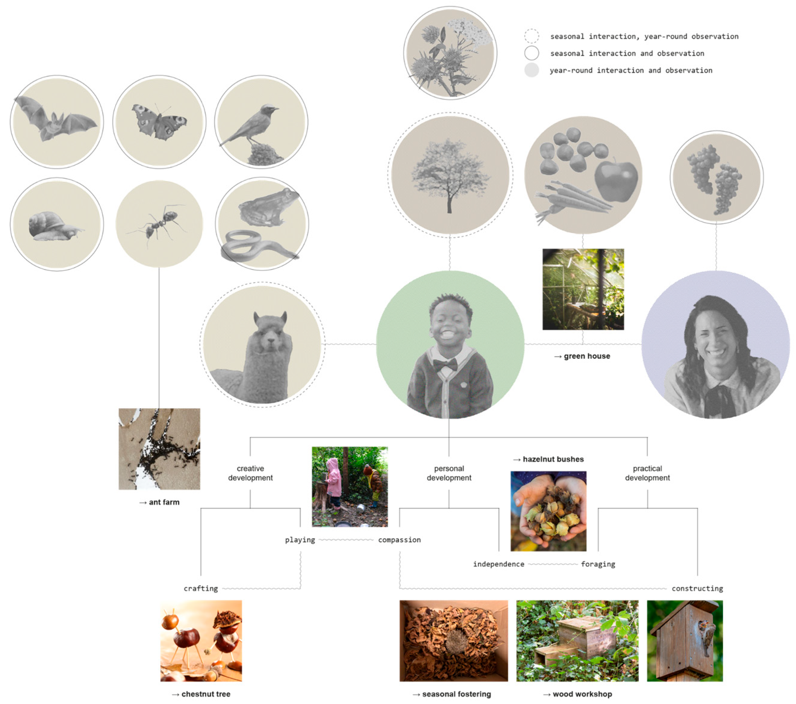
3.1.1. Networks, Nodes and Relations
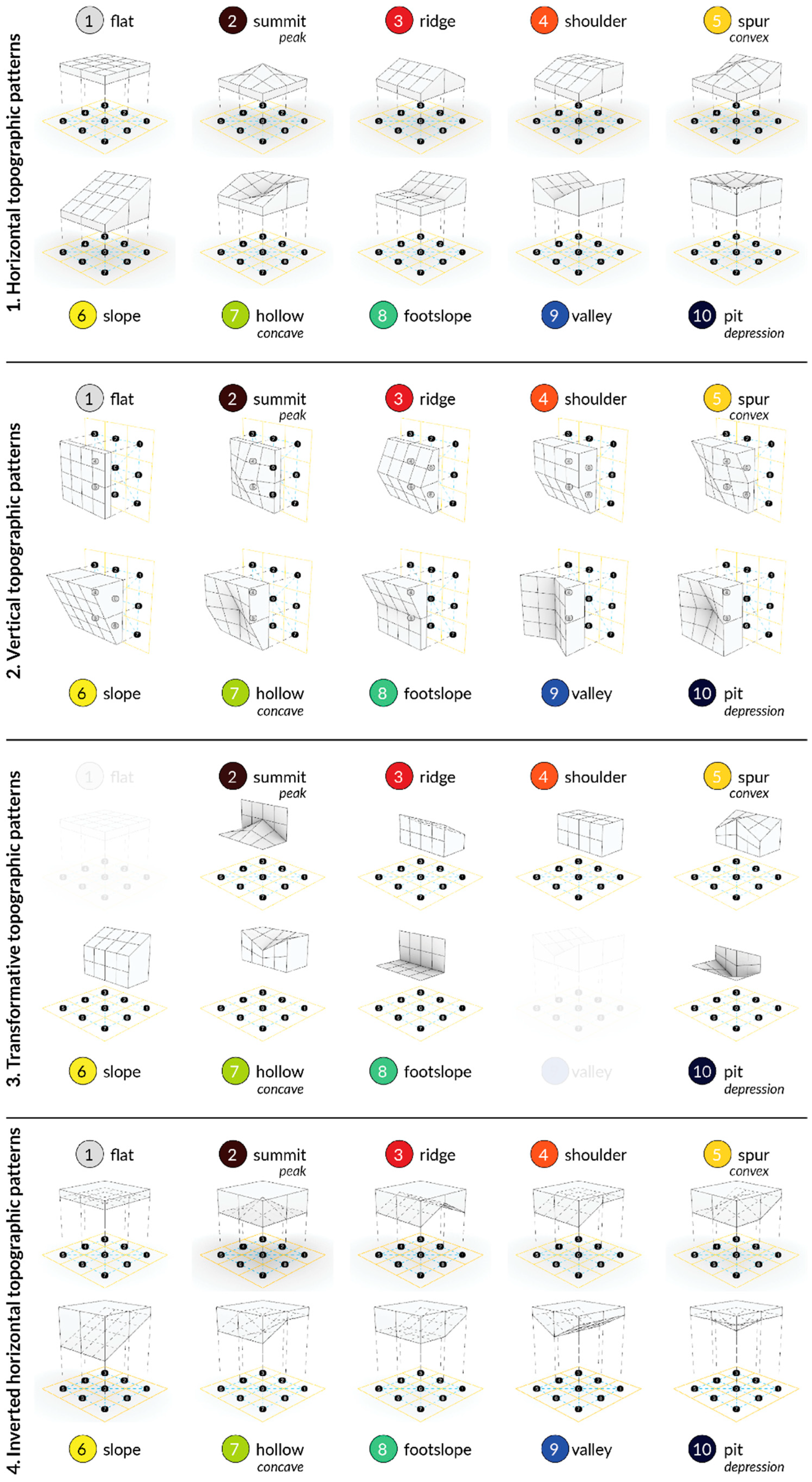
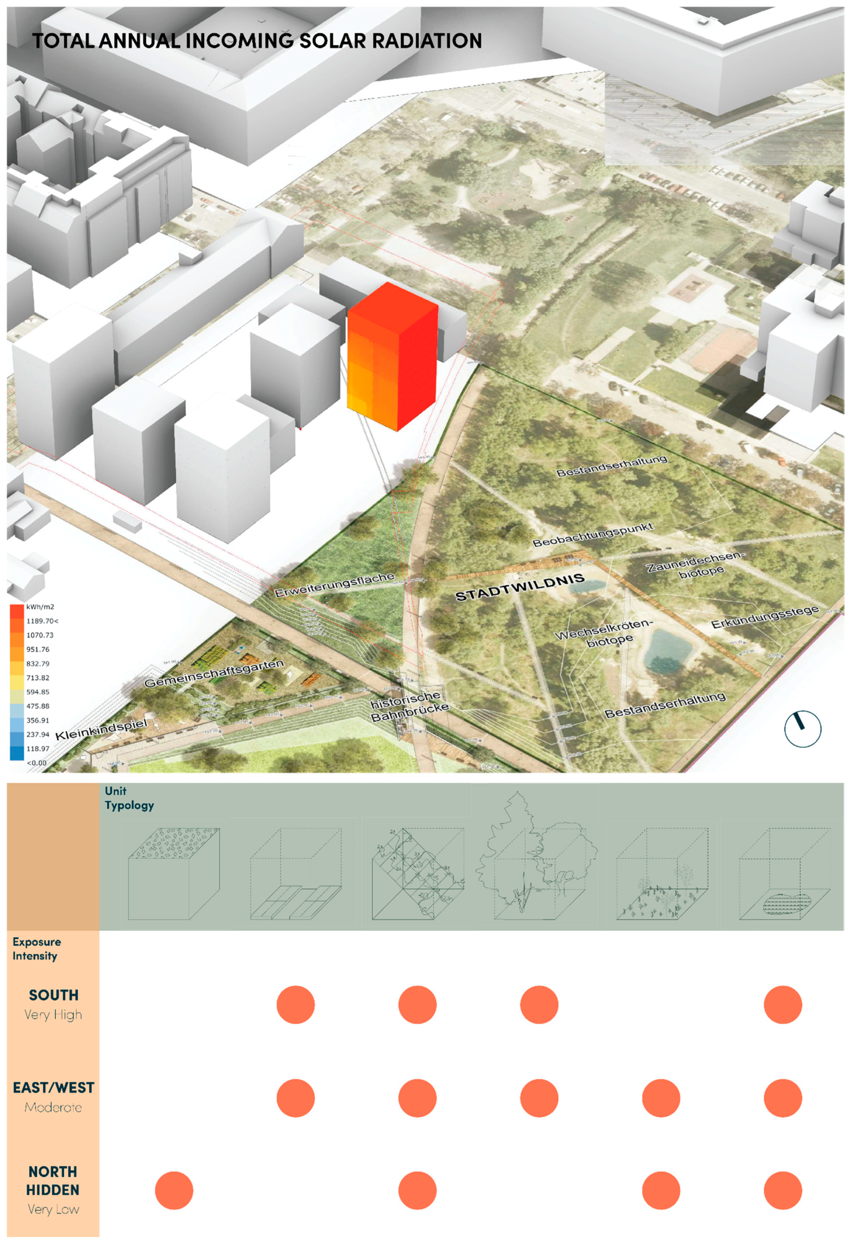
3.1.2. Urban LandForm
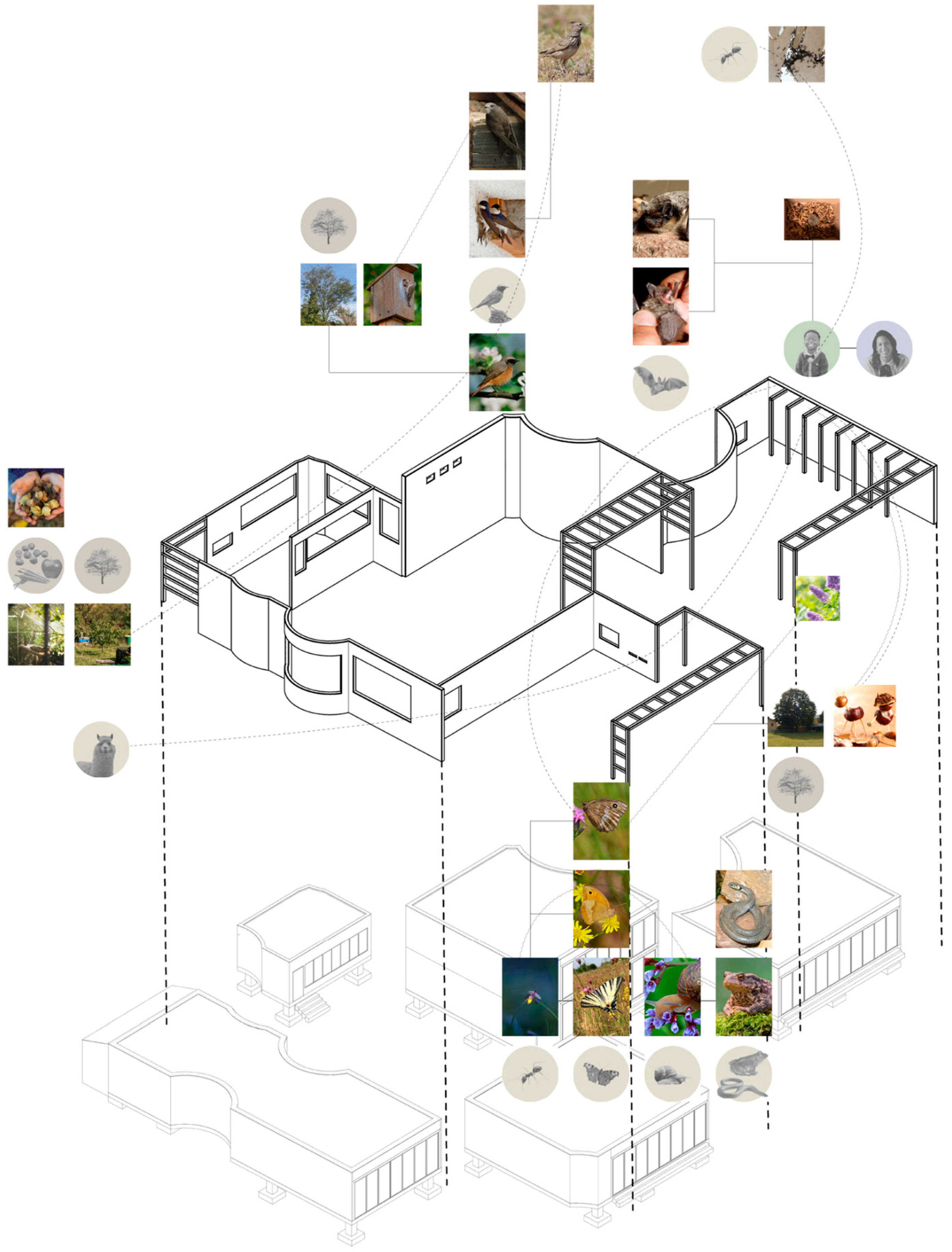
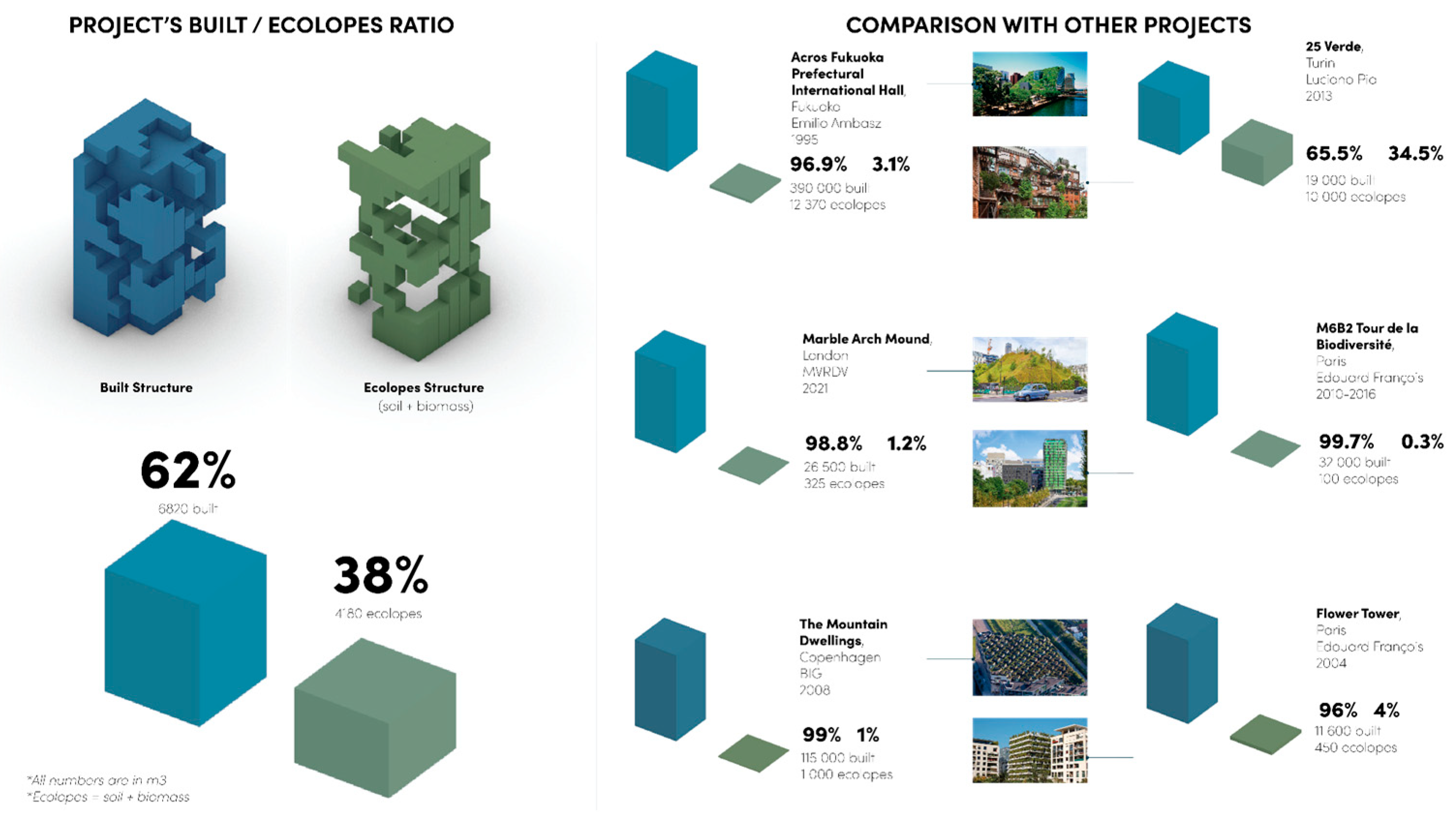
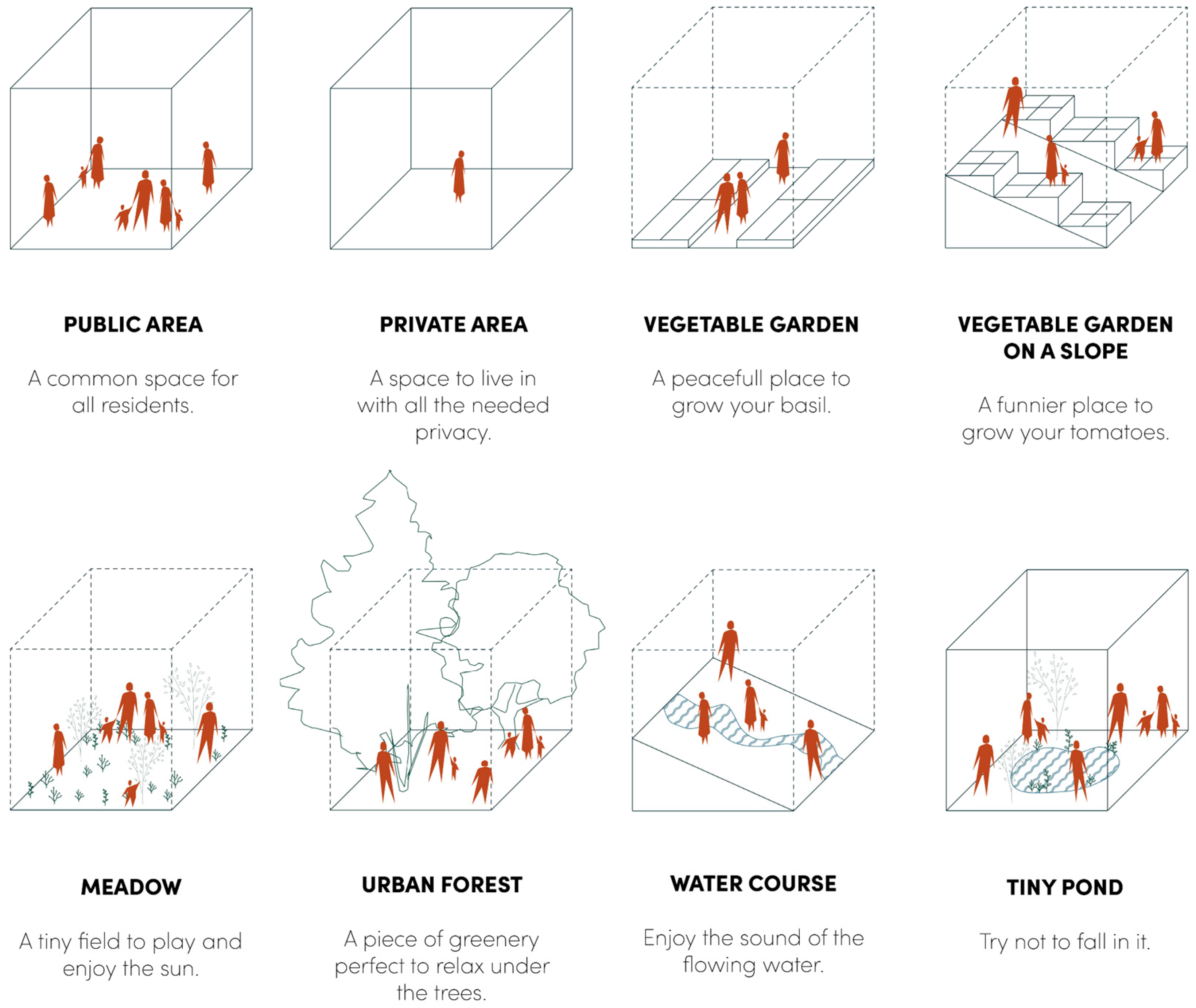
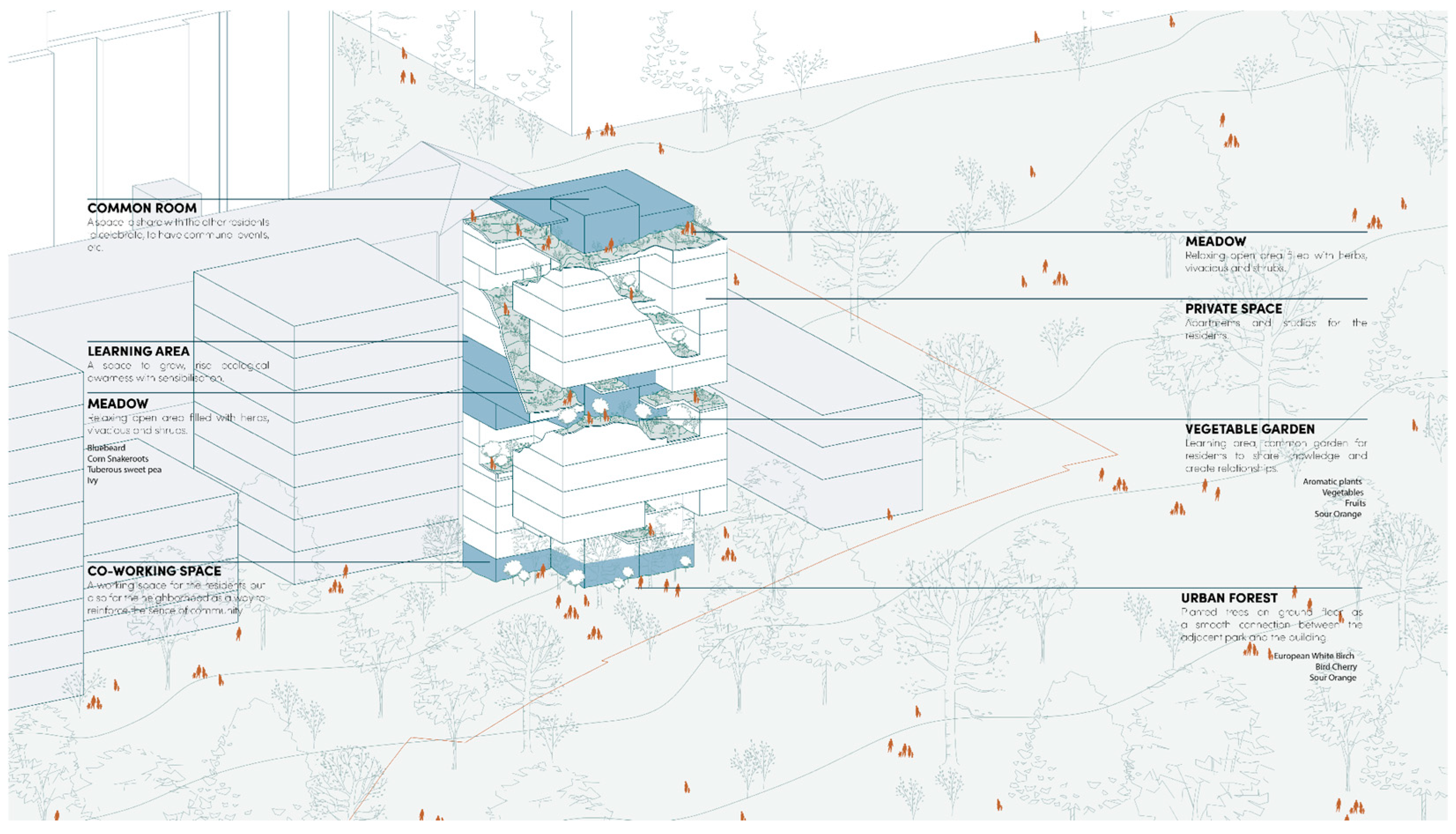
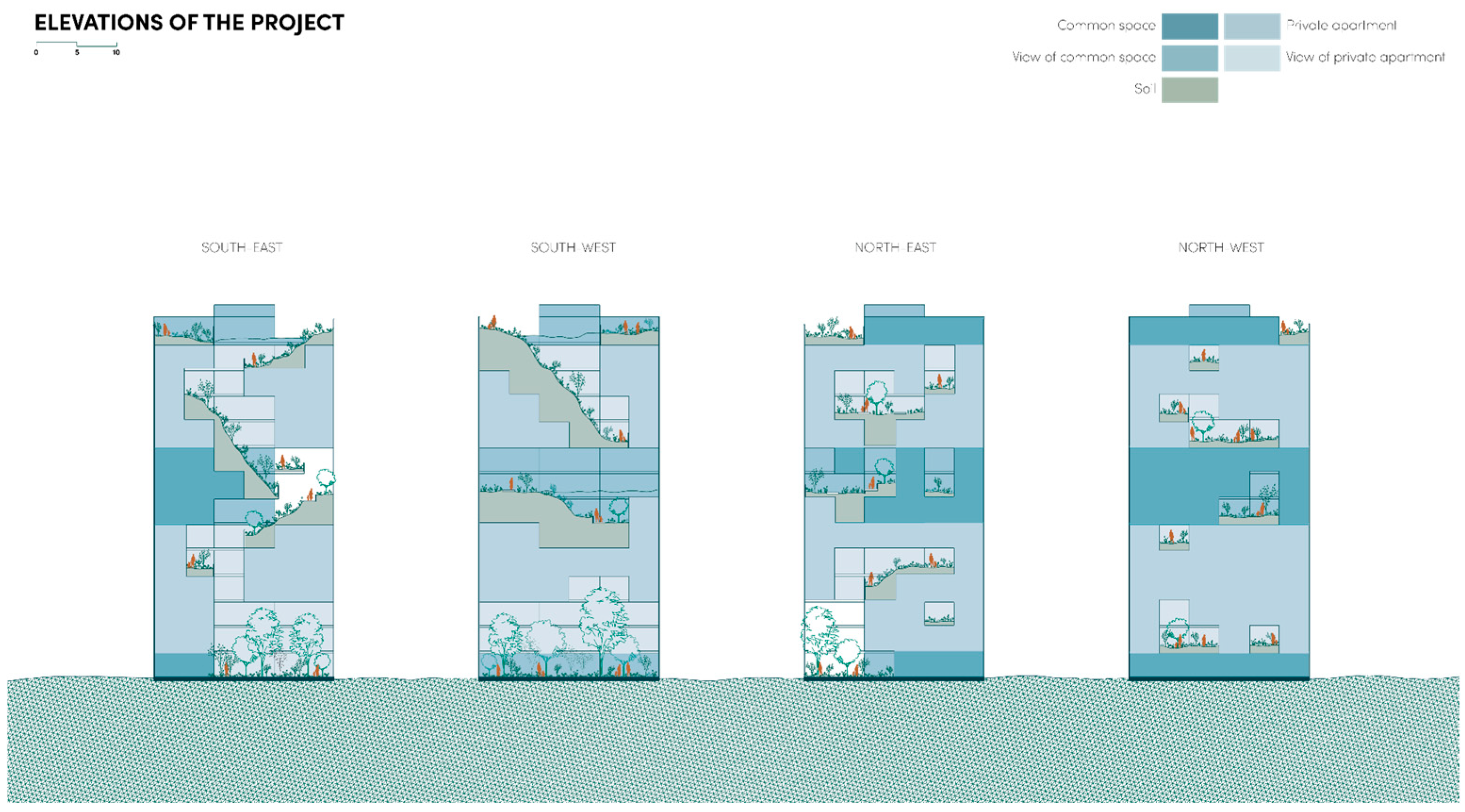
3.2. Design Cases
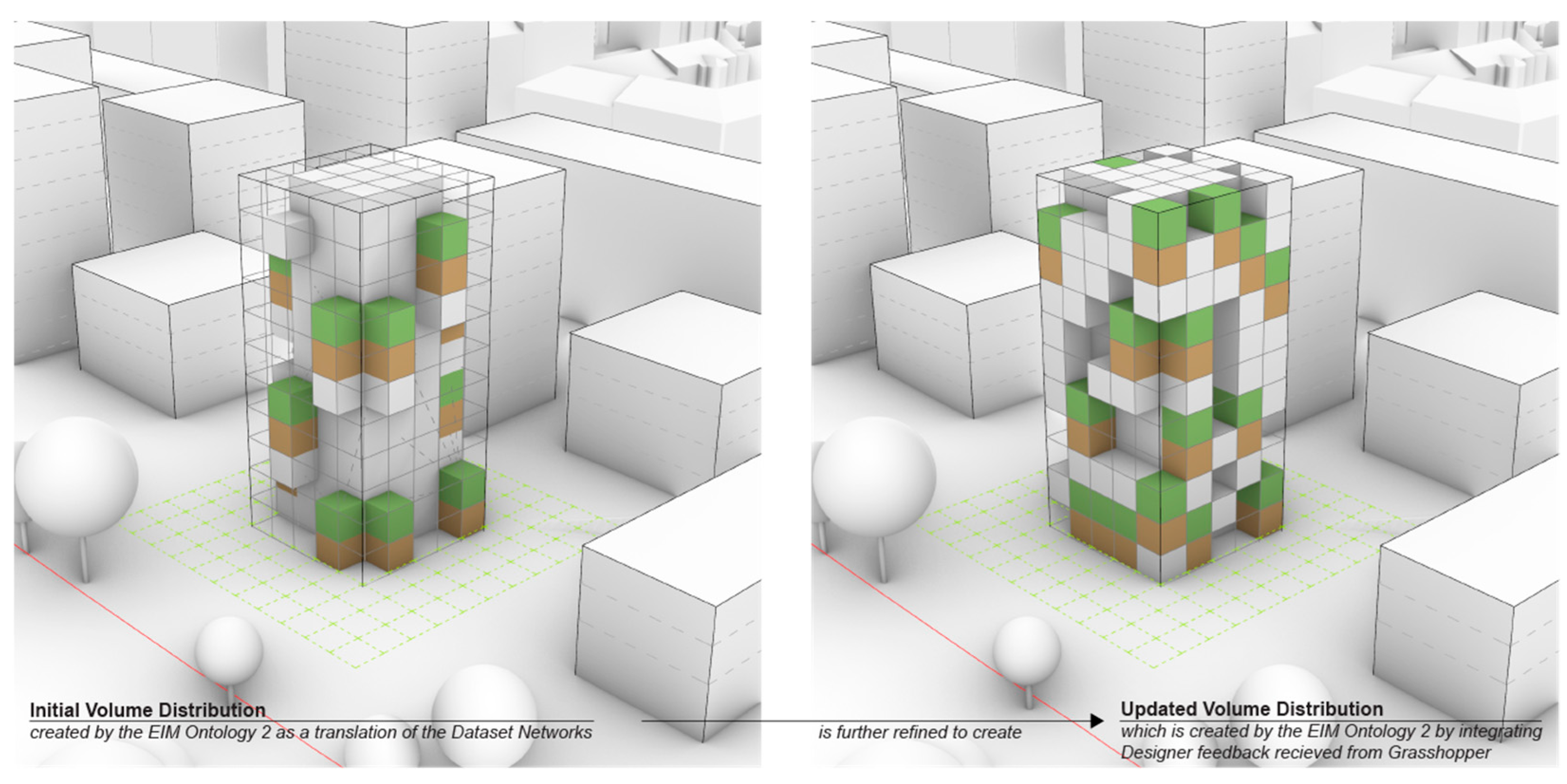
3.3. Computational Components
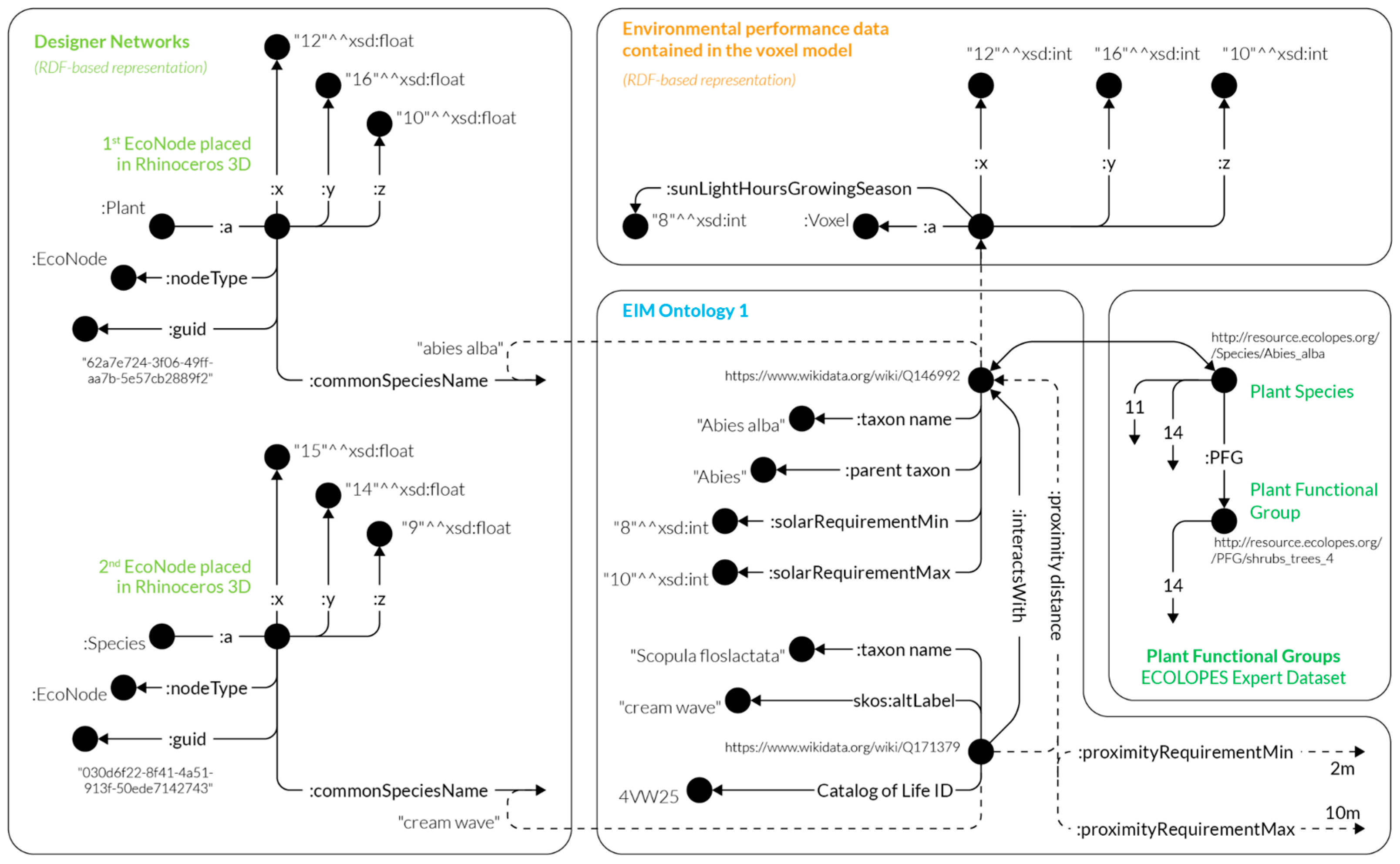
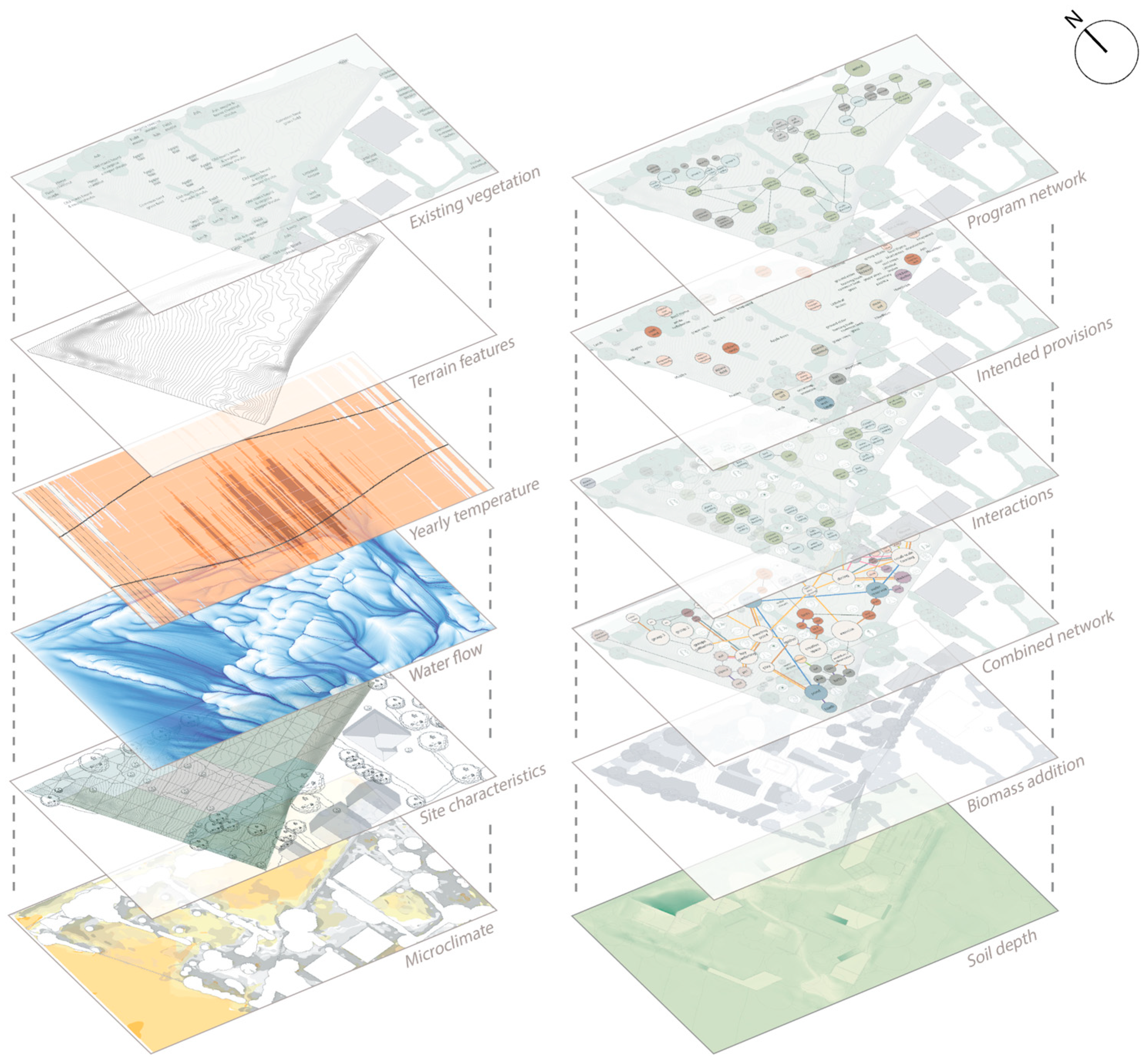
3.3.1. EIM Ontologies and Knowledge Graph
3.3.2. ECOLOPES Voxel Model
3.3.3. ECOLOPES Computational Model (Rule-Based Process)
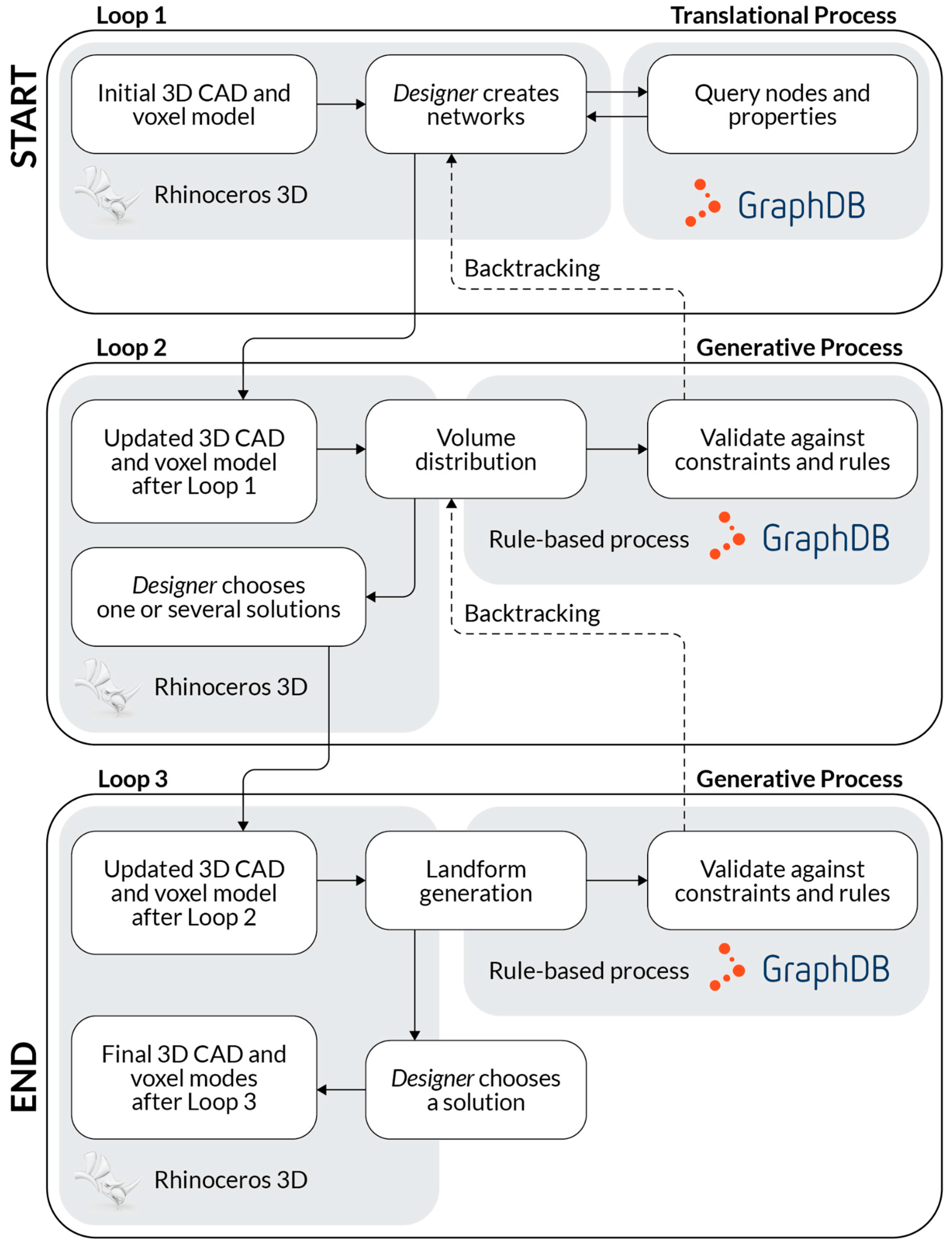
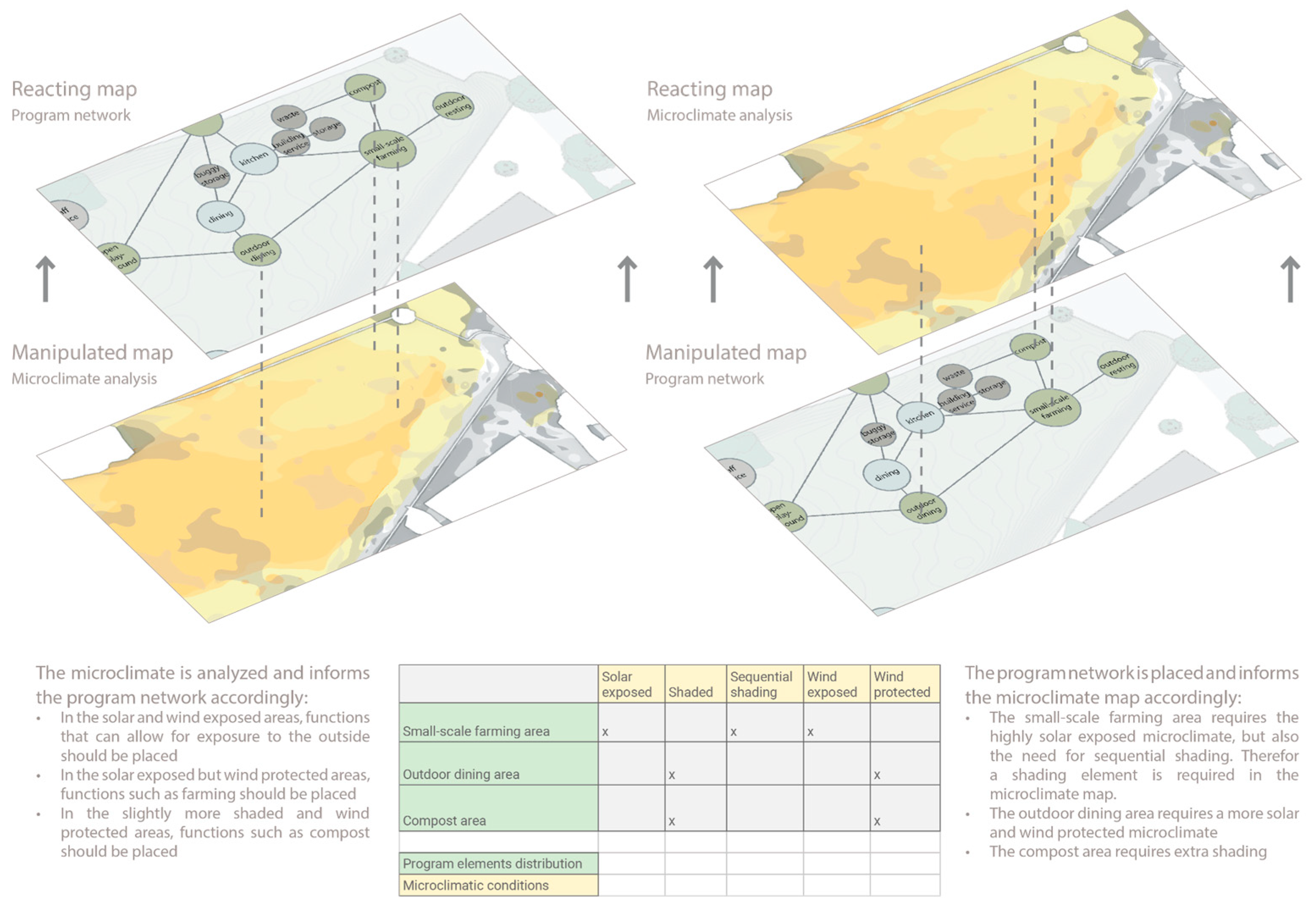
3.4. Computational Workflow
3.4.1. The Translational Process
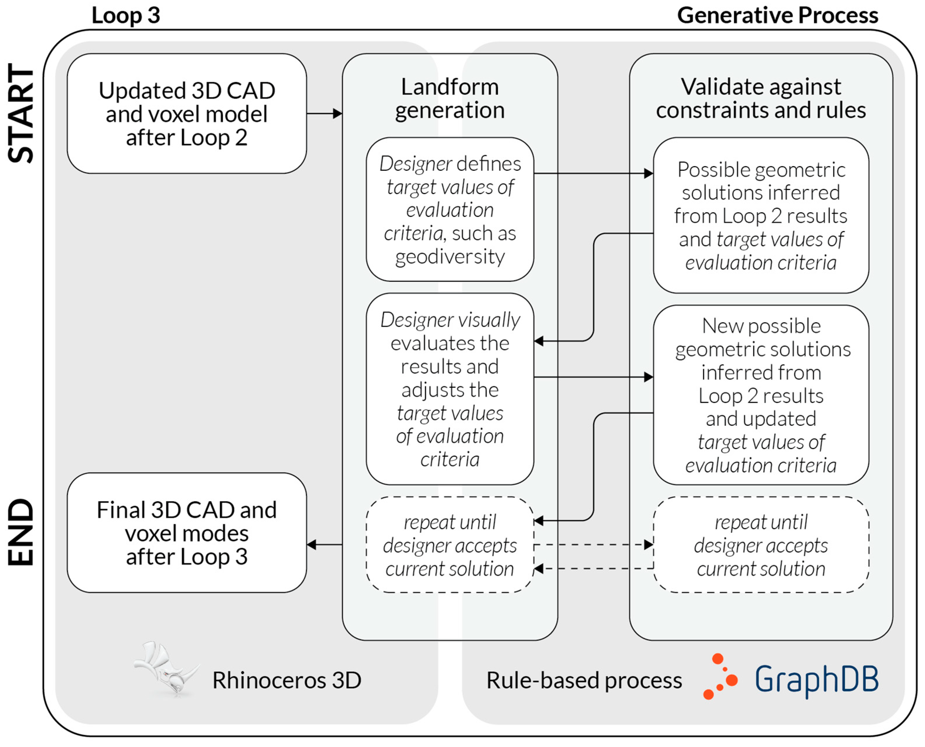
3.4.2. The Generative Process
3.5. Validation of the Conceptual Framework
4. Discussion
5. Conclusions
Author Contributions
Funding
Data Availability Statement
Acknowledgments
Conflicts of Interest
Abbreviations
| ANT | Actor–network theory |
| CZ | Critical zone |
| EIM | ECOLOPES Information Model |
| OWL | Web Ontology Language |
| RDB | Relational Database |
| RDF | Resource Description Framework |
| SDG | Sustainable Development Goal |
| SQL | Structured Query Language |
References
- Author United Nations Department of Economic and Social Affairs—Sustainable Development—The 17 Goals. 2024. Available online: https://sdgs.un.org/goals (accessed on 10 February 2025).
- United Nations—Progress Towards the Sustainable Development Goals. 2024. Available online: https://unstats.un.org/sdgs/files/report/2024/SG-SDG-Progress-Report-2024-advanced-unedited-version.pdf (accessed on 10 February 2025).
- Eurostat—How Has the EU Progressed Towards the Sustainable Development Goals? Available online: https://ec.europa.eu/eurostat/web/products-eurostat-news/-/wdn-20210615-1 (accessed on 10 February 2025).
- European Commission—The European Green Deal. Available online: https://commission.europa.eu/strategy-and-policy/priorities-2019-2024/european-green-deal_en (accessed on 10 February 2025).
- European Environment Agency—Soil and United Nations Sustainable Development Goals. Available online: https://www.eea.europa.eu/en/analysis/maps-and-charts/soil-and-united-nations-sustainable (accessed on 10 February 2025).
- Hensel, M.; Sunguroğlu Hensel, D. Nature-integrated Design—Opportunity and Challenges. In Intelligent Buildings; Clements-Croome, D., Ed.; ICE Publishing: London, UK, 2024; pp. 95–106. [Google Scholar] [CrossRef]
- National Research Council. Basic Research Opportunities in Earth Science; The National Academies Press: Washington, DC, USA, 2001. [CrossRef]
- Ludwig, F.; Hensel, M.; Weisser, W.W. ECOLOPES Gebäudehüllen als biodiverse Lebensräume. In Bauen von Morgen—Zukunftsthemen und Szenarien; Bundesamt für Bauwesen und Raumordnung: Bonn, Germany, 2021; pp. 84–89. [Google Scholar]
- Perini, K.; Barath, S.; Canepa, M.; Hensel, M.; Mimet, A.; Mosca, F.; Roccotiello, E.; Salami, T.; Sunguroglu Hensel, D.; Tyc, J.; et al. ECOLOPES: A multi-species design approach to building envelope design for regenerative urban ecosystems. In Proceedings of the Responsive Cities Design with Nature Symposium, Institute of Advanced Architecture Catalonia, Barcelona, Spain, 11–12 November 2021. [Google Scholar]
- Weisser, W.; Hensel, M.; Barath, S.; Culshaw, V.; Grobman, Y.J.; Hauck, T.E.; Joschinski, J.; Ludwig, F.; Mimet, A.; Perini, K.; et al. Creating ecologically sound buildings by integrating ecology, architecture, and computational design. People Nat. 2022, 5, 4–20. [Google Scholar] [CrossRef]
- Calbi, M.; Boenisch, G.; Boulangeat, I.; Bunker, D.; Catford, J.A.; Changenet, A.; Culshaw, V.; Dias, A.S.; Hauck, T.E.; Joschinski, J.; et al. A novel framework to generate plant functional groups for ecological modelling. Ecol. Indic. 2024, 166, 112370. [Google Scholar] [CrossRef]
- Joschinski, J.; Boulangeat, I.; Calbi, M.; Hauck, T.E.; Vogler, V.; Mimet, A. The ECOLOPES PLANT MODEL: A high-resolution model to simulate plant community dynamics in cities and other human-dominated and managed environments. bioRxiv 2024. [Google Scholar] [CrossRef]
- Schröder, A.; Schloter, M.; Roccotiello, E.; Weisser, W.W.; Schulz, S. Improving ecosystem services of urban soils—How to manage the microbiome of Technosols? Front. Environ. Sci. 2024, 12, 1460099. [Google Scholar] [CrossRef]
- Grobman, Y.J.; Weisser, W.W.; Shwartz, A.; Kozlovsky, R.; Ferdman, A.; Ludwig, F.; Hoek, T.; Perini, K.; Selvan, S.U.; Saroglu, S.; et al. Architectural Multispecies Building Design: Concepts, challenges, and design process. Sustainability 2024, 15, 15480. [Google Scholar] [CrossRef]
- Selvan, S.U.; Saroglou, S.T.; Joschinski, J.; Calbi, M.; Vogler, V.; Barath, S.; Grobman, Y.J. Towards multi-species building envelopes: A critical literature review of multi-criteria decision-making for design support. Build. Environ. 2023, 231, 110006. [Google Scholar] [CrossRef]
- Mosca, F.; Calbi, M.; Roccotiello, E.; Perini, K. A computational approach to assess the effects of ecological building envelopes on outdoor thermal comfort. Sustain. Cities Soc. 2025, 120, 106170. [Google Scholar] [CrossRef]
- Cresswell, J.W. Research Design, Qualitative, Quantitative and Mixed Method Approaches, 4th ed.; Sage: Thousand Oaks, CA, USA, 2014. [Google Scholar]
- Lenzholzer, S.; Duchhart, I.; van den Brink, A. The relationship between research and design. In Research in Landscape Architecture—Methods and Methodology; van den Brink, A., Bruns, D., Tobi, H., Bell, S., Eds.; Routledge: Oxon, UK, 2017; pp. 54–64. [Google Scholar]
- Stadt Wien. ViennaGIS—Das Geografische Informationssystem der Stadt Wien—Daten und Nutzung. 2024. Available online: https://www.wien.gv.at/viennagis/ (accessed on 28 October 2024).
- Lindsay, J.B. Whitebox GAT: A case study in geomorphometric analysis. Comput. Geosci. 2016, 95, 75–84. [Google Scholar] [CrossRef]
- Rittel, H. Der Planungsprocess als iterativer Vorgang von Varietätserzeugung und Varietätseinschränkung. In Arbeitsberichte zur Planungsmethodik—Entwurfsmethoden in der Bauplanung; Joedicke, J., Ed.; Karl Krämer Verlag: Stuttgart, Germany, 1970; pp. 17–31. [Google Scholar]
- Sunguroğlu Hensel, D.; Tyc, J.; Hensel, M. Data-driven Design for Architecture and Environment Integration: Convergence of data-integrated workflows for understanding and designing environments. Spool 2022, 9, 19–34. [Google Scholar] [CrossRef]
- Law, J. Notes on the theory of the actor-network: Ordering, strategy, and heterogeneity. Syst. Pract. 1992, 5, 379–393. [Google Scholar] [CrossRef]
- Dwiartama, A.; Rosin, C. Exploring agency beyond humans: The compatibility of Actor-Network Theory (ANT) and resilience thinking. Ecol. Soc. 2014, 19, 28. [Google Scholar] [CrossRef]
- Lozano, E. Community Design and Cultures in Cities; Cambridge University Press: Cambridge, UK, 1990. [Google Scholar]
- Olivera, V.M.A. Urban Morphology—An Introduction to the Study of the Physical Form of Cities; Springer: Cham, Switzerland, 2016. [Google Scholar]
- Rudnick, D.; Ryan, S.; Beier, S.; Cushman, S.; Diefenbach, F.; Epps, C.; Gerber, L.; Harrter, J.; Jenness, J.; Kintsch, J.; et al. The role of landscape connectivity in planning and implementing conservation and restoration priorities. Issues Ecol. 2012, 16, 1–20. [Google Scholar]
- Costanza, J.K.; Terando, A.J. Landscape connectivity planning for adaptation to future climate and land-use change. Curr. Landsc. Ecol. Rep. 2019, 4, 1–13. [Google Scholar] [CrossRef]
- Lookingbill, T.R.; Minor, E.S.; Mullis, C.S.; Nunez-Mir, G.C.; Johnson, P. Connectivity in the Urban Landscape (2015–2020): Who? Where? What? When? Why? and How? Curr. Landsc. Ecol. Rep. 2022, 7, 1–14. [Google Scholar] [CrossRef]
- Alberti, M.; Palkovac, E.P.; Des Roches, S.; De Meester, L.; Brans, K.I.; Govaert, L.; Grimm, N.B.; Harris, N.C.; Hendry, A.P.; Schell, C.J.; et al. The complexity of urban eco-evolutionary dynamics. BioScience 2020, 70, 772–793. [Google Scholar] [CrossRef]
- Zurlini, G.; Jones, K.B.; Riitters, K.H.; Li, B.L.; Petrosillo, I. Early warning signals of regime shifts from cross-scale connectivity of land-cover patterns. Ecol. Indic. 2014, 45, 549–560. [Google Scholar] [CrossRef]
- Pelorosso, R.; Gobattoni, F.; Geri, F.; Monaco, R.; Leone, A. Evaluation of ecosystem services related to bio-energy landscape connectivity (BELC) for land use decision making across different planning scales. Ecol. Indic. 2016, 61, 114–129. [Google Scholar] [CrossRef]
- Waldheim, C. Landscape as Urbanism; Princeton University Press: Princeton, NJ, USA, 2016. [Google Scholar]
- Allen, S. From the Biological to the Geological. In Landform Building; Allen, S., McQuade, M., Eds.; Lars Müller: Baden, Switzerland, 2011; pp. 20–37. [Google Scholar]
- Gray, M. Geodiversity: Valuing and Conserving Abiotic Nature; Wiley: Chichester, UK, 2008. [Google Scholar]
- Gray, M. Geodiversity: Developing the paradigm. Proc. Geol. Assoc. 2004, 119, 287–298. [Google Scholar] [CrossRef]
- Vernham, G.; Bailey, J.J.; Chase, J.M.; Hjort, J.; Field, R.; Schrodt, F. Understanding trait diversity: The role of geodiversity. Trends Ecol. Evol. 2023, 38, 736–748. [Google Scholar] [CrossRef]
- Alahuta, J.; Ala-Hulkko, T.; Tukiainen, H.; Purola, L.; Akujärvi, A.; Lampinen, R.; Hjort, J. The role of geodiversity in providing ecosystem services at broader scales. Ecol. Indic. 2018, 91, 47–56. [Google Scholar] [CrossRef]
- Brazier, V.; Bruneau, P.M.C.; Gordon, J.E.; Rennie, A.F. Making Space for Nature in a Changing Climate: The Role of Geodiversity in Biodiversity Conservation. Scot. Geogr. J. 2012, 128, 211–233. [Google Scholar] [CrossRef]
- Tukiainen, H.; Kiuttu, M.; Kalliola, R.; Alahuta, J.; Hjort, J. Landforms contribute to plant biodiversity at alpha, beta, and gamma levels. J. Biogeogr. 2019, 46, 1699–1710. [Google Scholar] [CrossRef]
- Tukiainen, H.; Maliniemi, T.; Alahuta, J.; Hjort, J.; Lindholm, M.; Salminen, H.; Snåre, H.; Toivanen, M.; Vilmi, A.; Heino, J. Quantifying alpha, beta and gamma geodiversity. Prog. Phys. Geog. 2022, 47, 140–151. [Google Scholar] [CrossRef]
- Gruber, T. Ontology. In Encyclopedia of Database Systems; Liu, L., Özsu, M., Eds.; Springer: Cham, Switzerland, 2016; pp. 1–3. [Google Scholar] [CrossRef]
- Gruber, T.R. A translation approach to portable ontology specifications. Knowl. Acquis. 1993, 5, 199–220. [Google Scholar] [CrossRef]
- Hogan, A.; Blomqvist, E.; Cochez, M.; D’amato, C.; De Melo, G.; Gutierrez, C.; Kirrane, S.; Labra Gayo, J.E.; Navigli, R.; Neumaier, S.; et al. Knowledge graphs. ACM Comput. Surv. 2021, 54, 71. [Google Scholar] [CrossRef]
- Fensel, D.; Simsek, U.; Angele, K.; Huaman, E.; Elias, K.; Panasiuk, O.; Toma, I.; Umbrich, J.; Wahler, A. Knowledge Graphs—Methodology, Tools and Selected Use Cases; Springer: Cham, Switzerland, 2020. [Google Scholar]
- Pruski, C.; Sunguroğlu Hensel, D. The Role of Information Modelling and Computational Ontologies to Support the Design, Planning, and Management of Urban Environments: Current Status and Future Challenges. In Informed Urban Environments—Data-integrated Design for Human and Ecology-Centred Perspectives; Chokhachian, A., Hensel, M., Perini, K., Eds.; Springer: Cham, Switzerland, 2022; pp. 51–70. [Google Scholar] [CrossRef]
- Ahmeti, A.; Sunguroğlu Hensel, D.; Pruski, C.; Tyc, J.; Hensel, M. Enabling Biodiversity-informed Architecture through Ontology-driven Data Integration. Appl. Sci. 2025. submitted. [Google Scholar]
- Tyc, J.; Selami, T.; Sunguroğlu Hensel, D.; Hensel, M. A Scoping Review of Voxel-based Applications to Enable Multi-Domain Data Integration in Architectural Design and Urban Planning. Architecture 2023, 3, 137–174. [Google Scholar] [CrossRef]
- Kaufman, A.; Cohen, D.; Yagel, R. Volume Graphics. Computer 1993, 26, 51–64. [Google Scholar] [CrossRef]
- Srihari, S.N. Representation of Three-Dimensional Digital Images. ACM Comput. Surv. 1981, 13, 399–424. [Google Scholar] [CrossRef]
- Tyc, J.; Ahmeti, A.; Sunguroğlu Hensel, D.; Hensel, M. The ECOLOPES Voxel Model: Multi-domain data integration for ontology-aided generative computational design of ecological building envelopes. Intell. Build. Int. 2025. submitted. [Google Scholar]
- Polleres, A. From SPARQL to rules (and back). In Proceedings of the 16th International Conference on World Wide Web (WWW ’07), Banff, AB, Canada, 8–12 May 2007; Association for Computing Machinery: New York, NY, USA, 2007; pp. 787–796. [Google Scholar] [CrossRef]
- Poggi, A.; Lembo, D.; Calvanese, D.; De Giacomo, G.; Lenzerini, M.; Rosati, R. Linking Data to Ontologies. In Journal on Data Semantics X; Lecture Notes in Computer Science, Volume 4900; Spaccapietra, S., Ed.; Springer: Berlin/Heidelberg, Germany, 2008. [Google Scholar] [CrossRef]
- Lobeck, A.K. Geomorphology: An Introduction to the Study of Landscapes; McGraw–Hill: New York, NY, USA, 1939. [Google Scholar]
- Pike, R.J.; Evans, I.S.; Hengl, T. Chapter 1 Geomorphometry: A Brief Guide. Dev. Soil Sci. 2009, 33, 3–30. [Google Scholar] [CrossRef]
- Evans, I.S. Geomorphometry and Landform Mapping: What Is a Landform? Geomorphology 2012, 137, 94–106. [Google Scholar] [CrossRef]
- Mark, D.M. Geomorphometric Parameters: A Review and Evaluation. Geogr. Annaler. Ser. A Phys. Geogr. 1975, 57, 165. [Google Scholar] [CrossRef]
- Smith, B.; Mark, D.M. Do Mountains Exist? Towards an Ontology of Landforms. Environ. Plann. B Plann. Des. 2003, 30, 411–427. [Google Scholar] [CrossRef]
- Jasiewicz, J.; Stepinski, T.F. Geomorphons—A pattern recognition approach to classification and mapping of landforms. Geomorphology 2013, 182, 147–156. [Google Scholar] [CrossRef]
- Potter, C.; Lobley, M. Processes of Countryside Change in Britain. Countryside 1990 Series 1996, 7; Department of the Environment: London, UK, 1996. [Google Scholar]
- Antrop, M. Landscape change: Plan or chaos? Landsc. Urban Plan. 1998, 41, 155–161. [Google Scholar] [CrossRef]
- Marcucci, D. Landscape history as a planning tool. Landsc. Urban Plan. 2000, 49, 67–81. [Google Scholar] [CrossRef]
- Grossmann, W.; Bellot, J. Systems analysis as a tool for rural planning. In Rural Planning from an Environmental Systems Perspective; Golley, F., Bellot, J., Eds.; Springer: New York, NY, USA, 1999; pp. 315–343. [Google Scholar]
- Wood, R.; Handley, J. Landscape Dynamics and the Management of Change. Landsc. Res. 2001, 26, 45–54. [Google Scholar] [CrossRef]
- Hensel, M. Geomorphic Tectonics. Technol. Archit. Des. 2023, 7, 14–17. [Google Scholar] [CrossRef]


Disclaimer/Publisher’s Note: The statements, opinions and data contained in all publications are solely those of the individual author(s) and contributor(s) and not of MDPI and/or the editor(s). MDPI and/or the editor(s) disclaim responsibility for any injury to people or property resulting from any ideas, methods, instructions or products referred to in the content. |
© 2025 by the authors. Licensee MDPI, Basel, Switzerland. This article is an open access article distributed under the terms and conditions of the Creative Commons Attribution (CC BY) license (https://creativecommons.org/licenses/by/4.0/).
Share and Cite
Hensel, M.; Tyc, J.; Ahmeti, A.; Sunguroğlu Hensel, D. An Ontology-Aided Generative Computational Design Process for Ecological Building Envelopes: Development of a Conceptual Framework for the Early Design Stage. Land 2025, 14, 840. https://doi.org/10.3390/land14040840
Hensel M, Tyc J, Ahmeti A, Sunguroğlu Hensel D. An Ontology-Aided Generative Computational Design Process for Ecological Building Envelopes: Development of a Conceptual Framework for the Early Design Stage. Land. 2025; 14(4):840. https://doi.org/10.3390/land14040840
Chicago/Turabian StyleHensel, Michael, Jakub Tyc, Albin Ahmeti, and Defne Sunguroğlu Hensel. 2025. "An Ontology-Aided Generative Computational Design Process for Ecological Building Envelopes: Development of a Conceptual Framework for the Early Design Stage" Land 14, no. 4: 840. https://doi.org/10.3390/land14040840
APA StyleHensel, M., Tyc, J., Ahmeti, A., & Sunguroğlu Hensel, D. (2025). An Ontology-Aided Generative Computational Design Process for Ecological Building Envelopes: Development of a Conceptual Framework for the Early Design Stage. Land, 14(4), 840. https://doi.org/10.3390/land14040840