An Integrated Geographical-Disaster Factor Approach for Sustainable Management: Case Study of Traditional Villages in Karst Mountains
Abstract
1. Introduction
- To quantitatively delineate the spatial distribution characteristics of all 757 traditional villages in Guizhou, identifying core clustering areas and directional trends.
- To systematically analyze the driving mechanisms behind this distribution by integrating key geographical factors (altitude, slope, and aspect) with critical disaster factors (flood and landslide susceptibility).
- To construct a robust spatially suitable evaluation model by innovatively coupling the objective statistical power of Geodetector with the structured decision-making framework of the AHP for weight assignment.
- Based on the evaluation results, to propose differentiated sustainable management and spatial governance strategies tailored to the specific suitability and risk profiles of different zones within the province.
2. Materials and Methods
2.1. Study Area
2.2. Data Sources
2.3. Research Methodologies
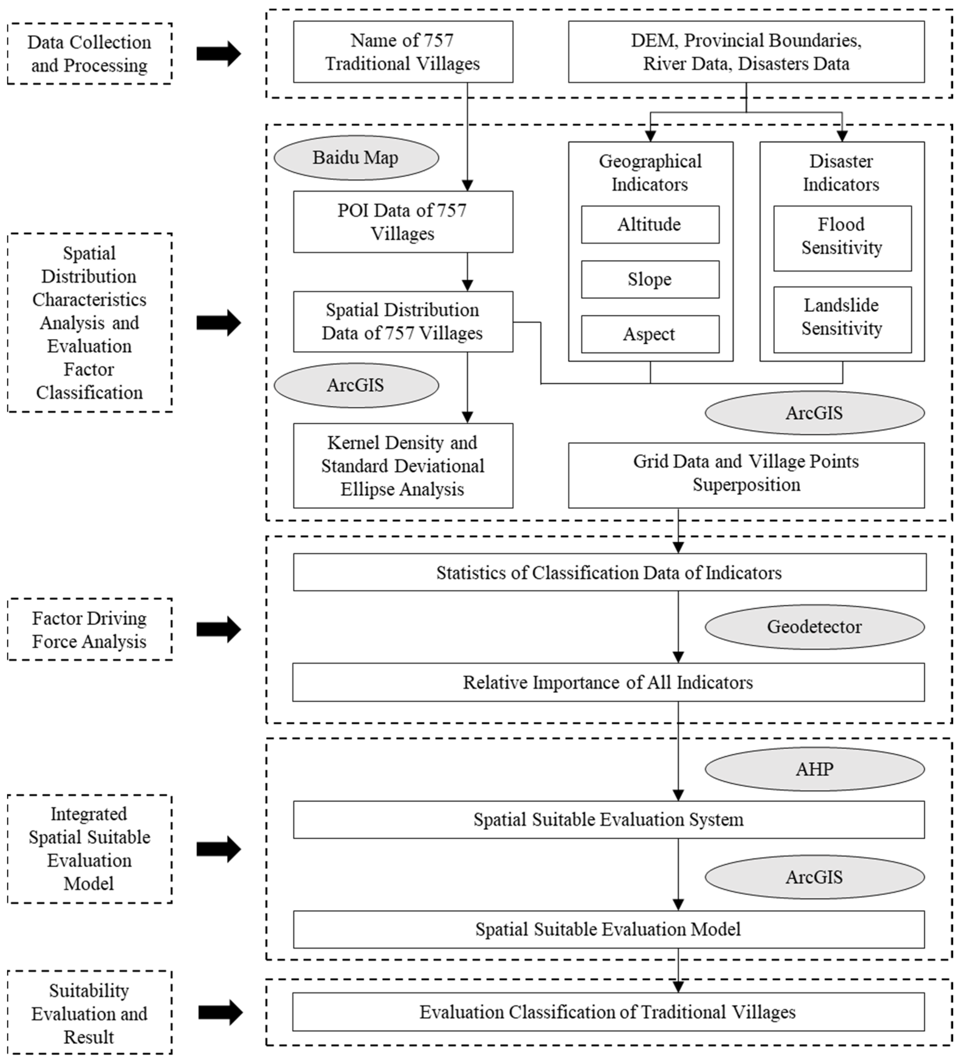
- Data collection and processing: data for 757 villages and key spatial factors were collected and standardized within a GIS platform.
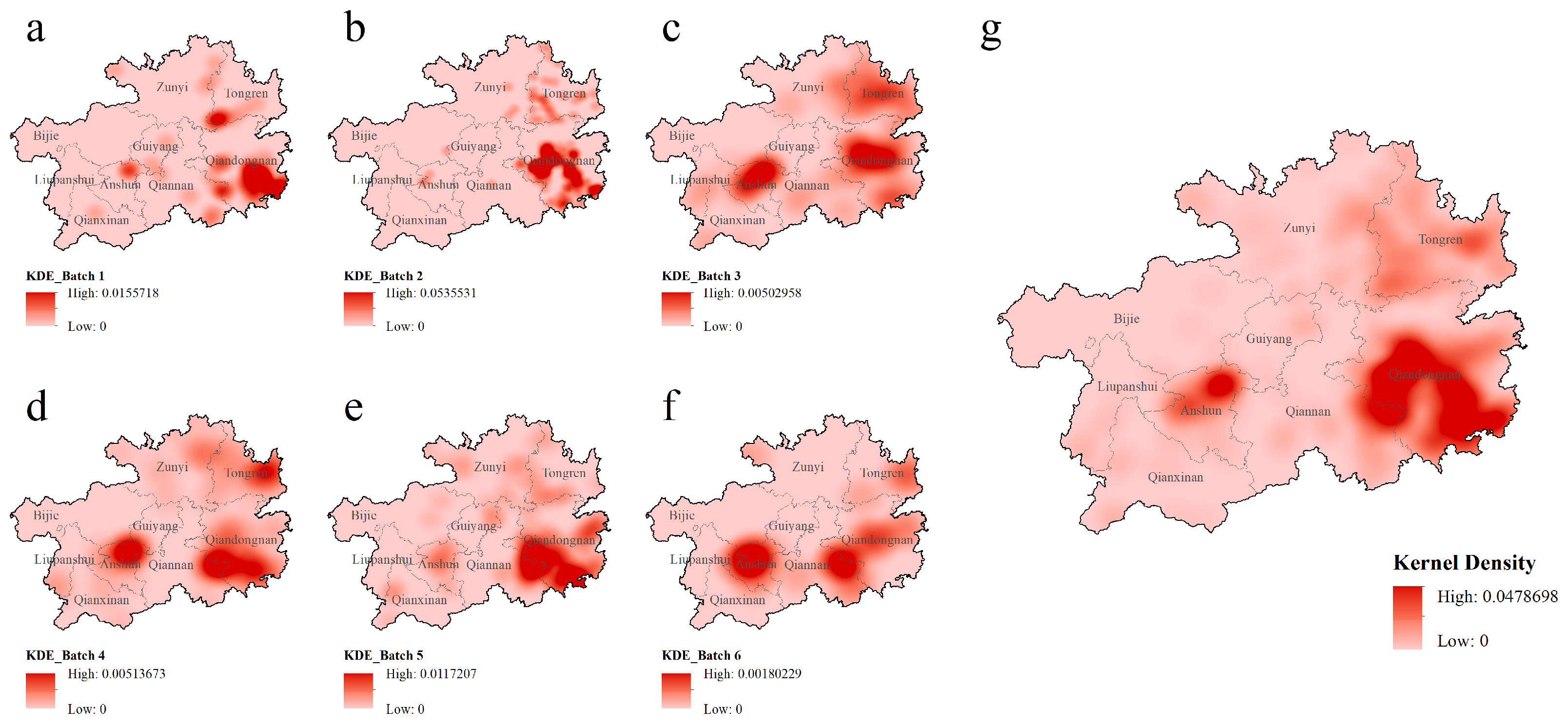
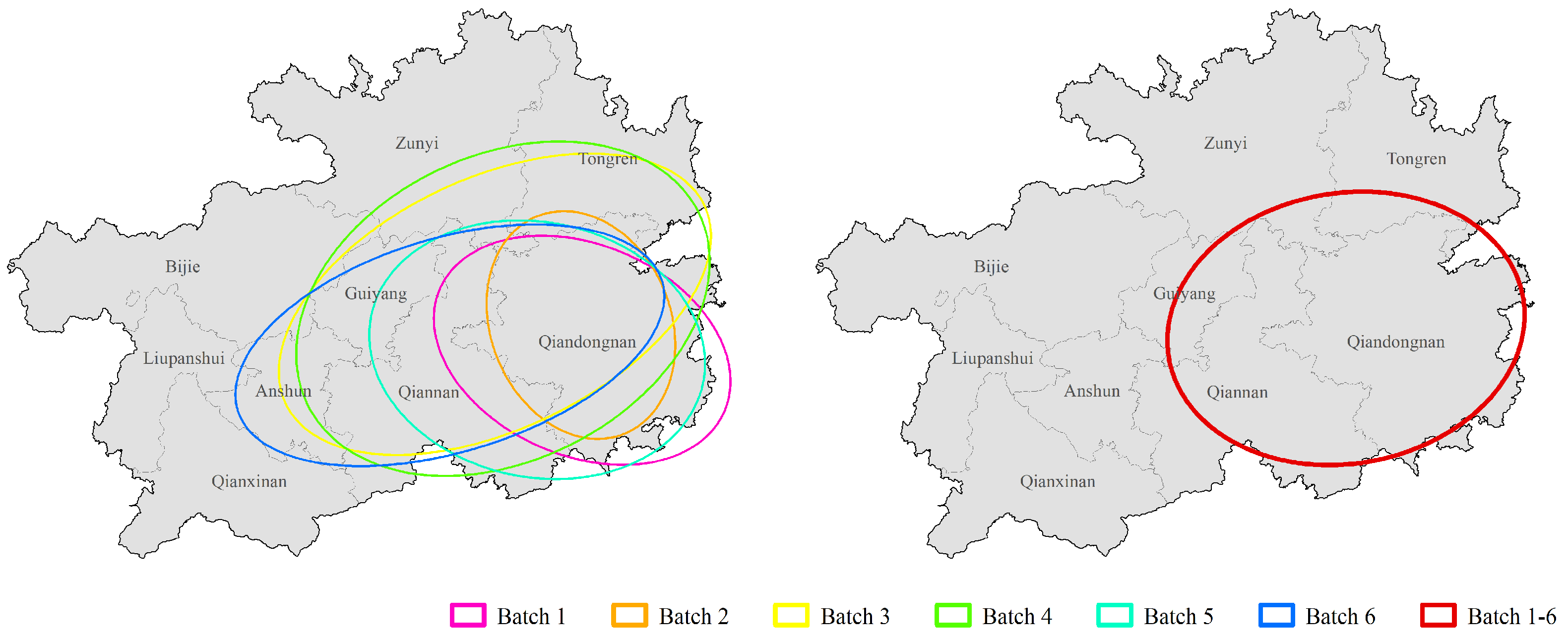
- Spatial distribution characteristics analysis: the spatial distribution pattern was analyzed using kernel density and standard deviational ellipse methods to identify clustering characteristics.
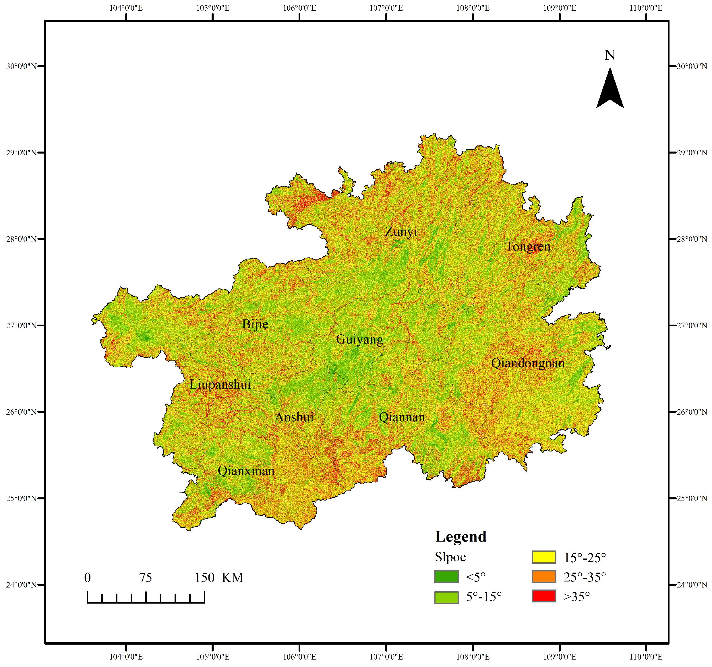
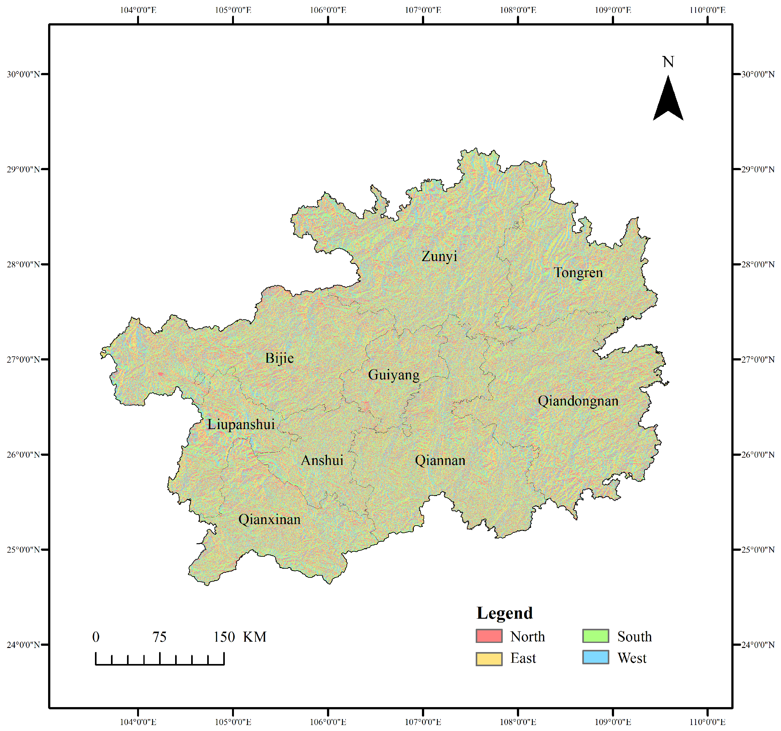
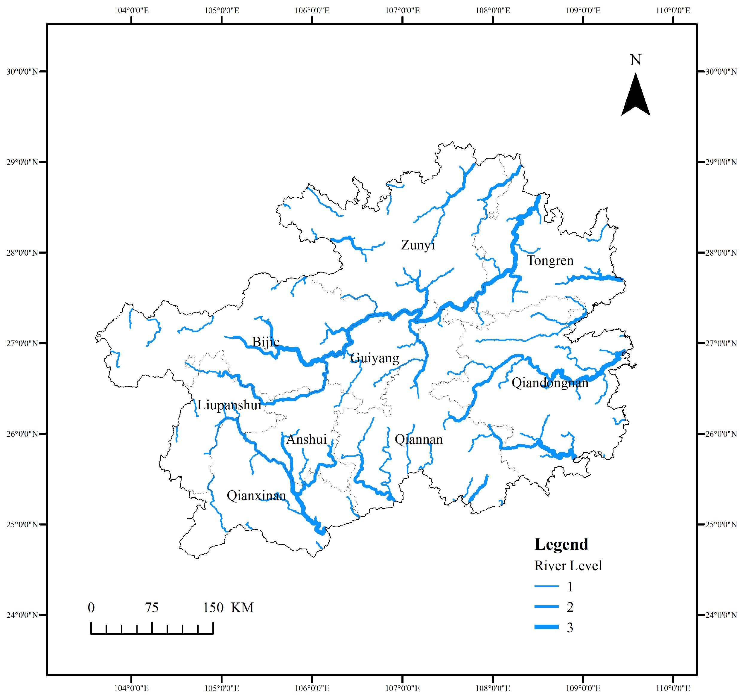
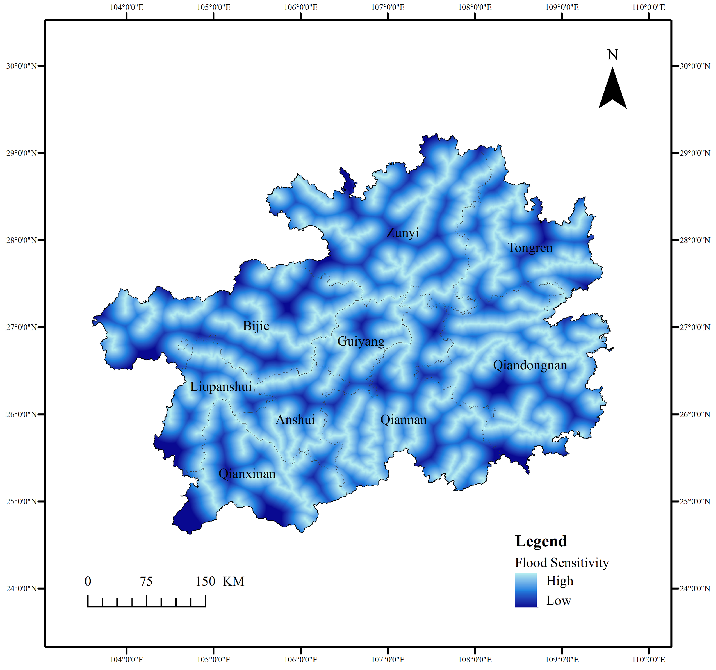
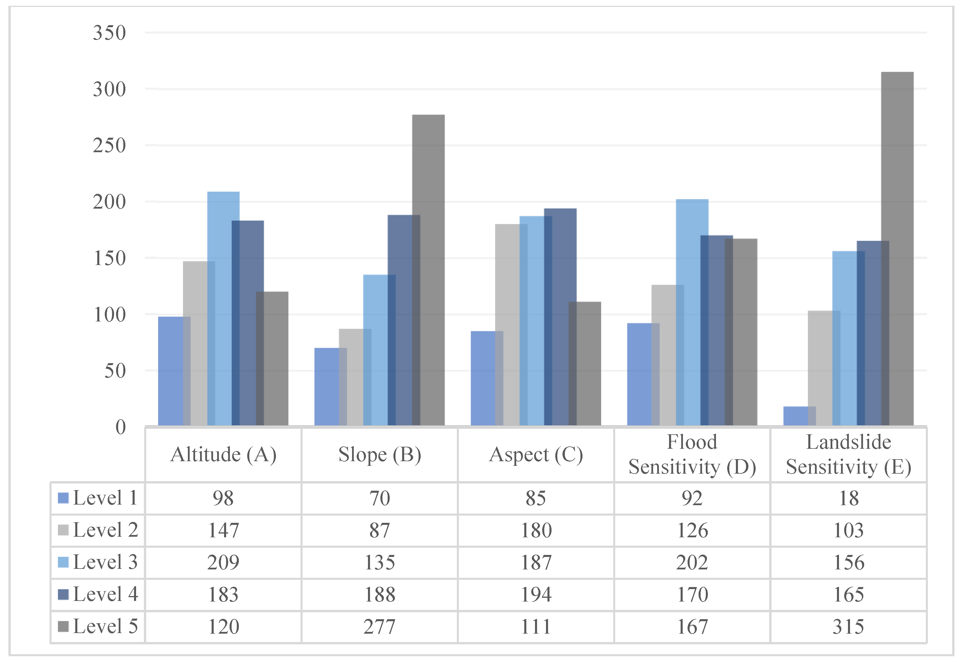
- Evaluation factor selection and classification: five evaluation factors (altitude, slope, aspect, flood, and landslide sensitivity) were selected and classified into different suitability levels.
- Factor driving force analysis: the Geodetector tool was applied to quantify each factor’s explanatory power and its interactive effects on village distribution.
- Integrated spatial suitability evaluation model: an integrated evaluation model was constructed by combining the objective weights from the Geodetector with the AHP to assign final factor weights.
- Suitability evaluation and result: a spatial suitability map was generated through weighted overlay analysis in GIS and classified into four distinct zones for result interpretation and policy formulation.
2.3.1. Data Collection and Processing
2.3.2. Spatial Distribution Characteristics Analysis
2.3.3. Evaluation Factor Selection and Classification
2.3.4. Factor Driving Force Analysis
2.3.5. Integrated Spatial Suitability Evaluation Model
2.3.6. Suitability Evaluation and Result
3. Research Results
3.1. Spatial Distribution Characteristics
3.1.1. Kernel Density Analysis
3.1.2. Standard Deviational Ellipse
3.2. Spatial Suitability Evaluation Model Implementation
3.2.1. Drivers’ Classification
3.2.2. Weight Assignment
3.2.3. Spatial Suitable Evaluation System
3.3. Spatial Suitability Evaluation Result
3.3.1. Evaluation Map Generation
3.3.2. Threshold Determination
3.3.3. Zoning Results and Analysis
4. Discussion
4.1. Interpretation of Key Findings
4.2. Model Innovation and Limitations
4.3. Policy Implications
5. Conclusions
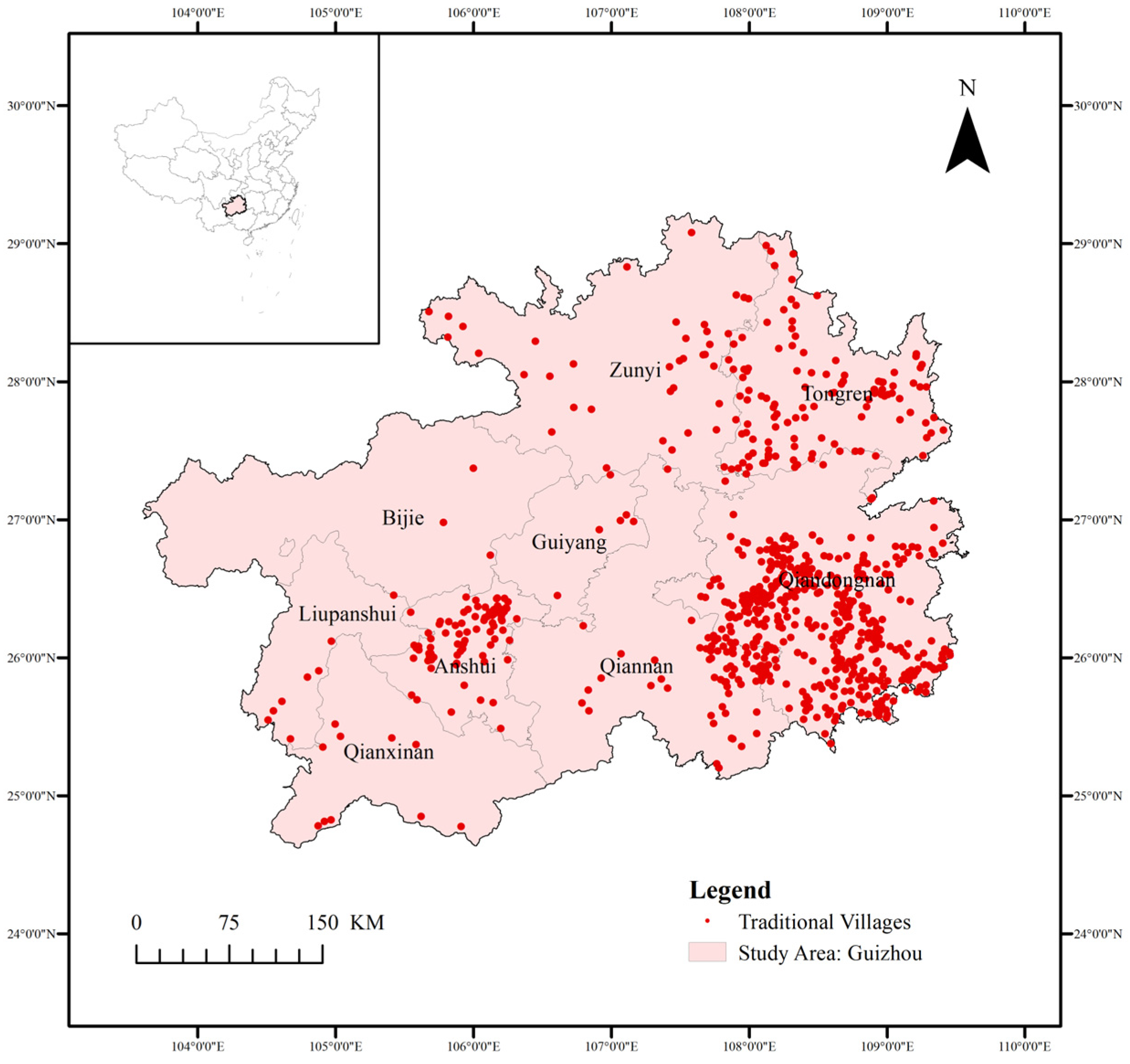
- The spatial distribution of traditional villages in Guizhou Province exhibits a dual-core clustering pattern (Qiandongnan and Anshun), with the largest number of villages and denser distribution in Qiandongnan. The overall distribution trend is centered in Qiandongnan and extends northeast-southwest. This pattern is highly consistent with Guizhou’s karst topography. Kernel density analysis and standard deviational ellipse analysis reveal that the distribution of traditional villages in Guizhou is not only constrained by geographic environment but also influenced by ethnic culture and historical development.
- This study focused on constructing a spatially suitable evaluation model for traditional villages in Guizhou based on geographical and hazard factors. Altitude (A), slope (B), and aspect (C) were selected as the basic geographical factors, and flood susceptibility (D) and landslide susceptibility (E) were selected as hazard factors. Geodetector analysis results showed that the influence of individual factors ranked as A > D > E > B > C, with altitude (q = 0.034685), flood susceptibility (q = 0.026732), and landslide susceptibility (q = 0.025567) having the strongest explanatory power. Interaction detector results showed that the interaction between altitude and landslide susceptibility was the highest (q = 0.151300), followed by the interaction between flood susceptibility and landslide susceptibility (q = 0.135186), both of which significantly outweighed the interaction effects of other factors.
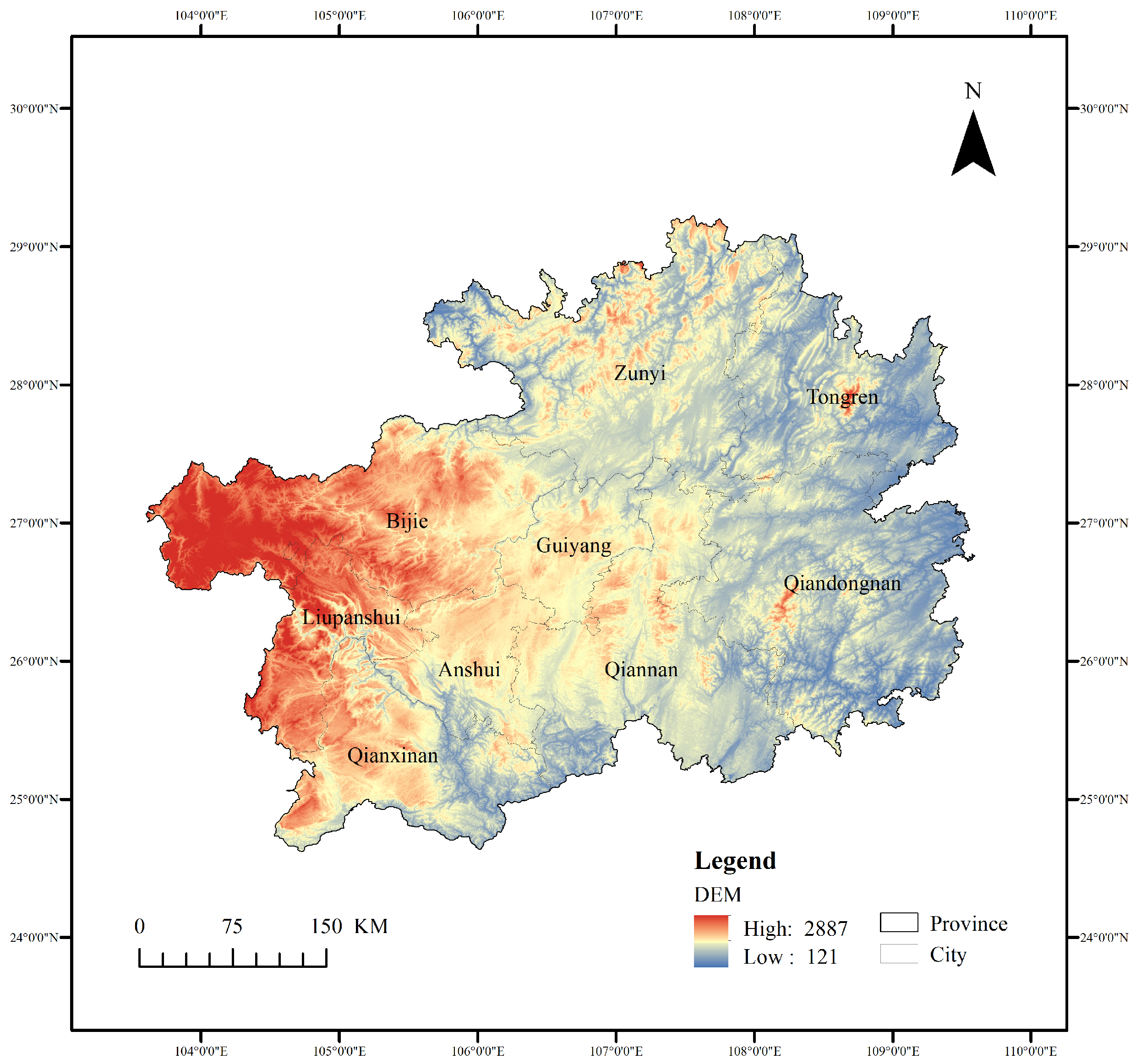
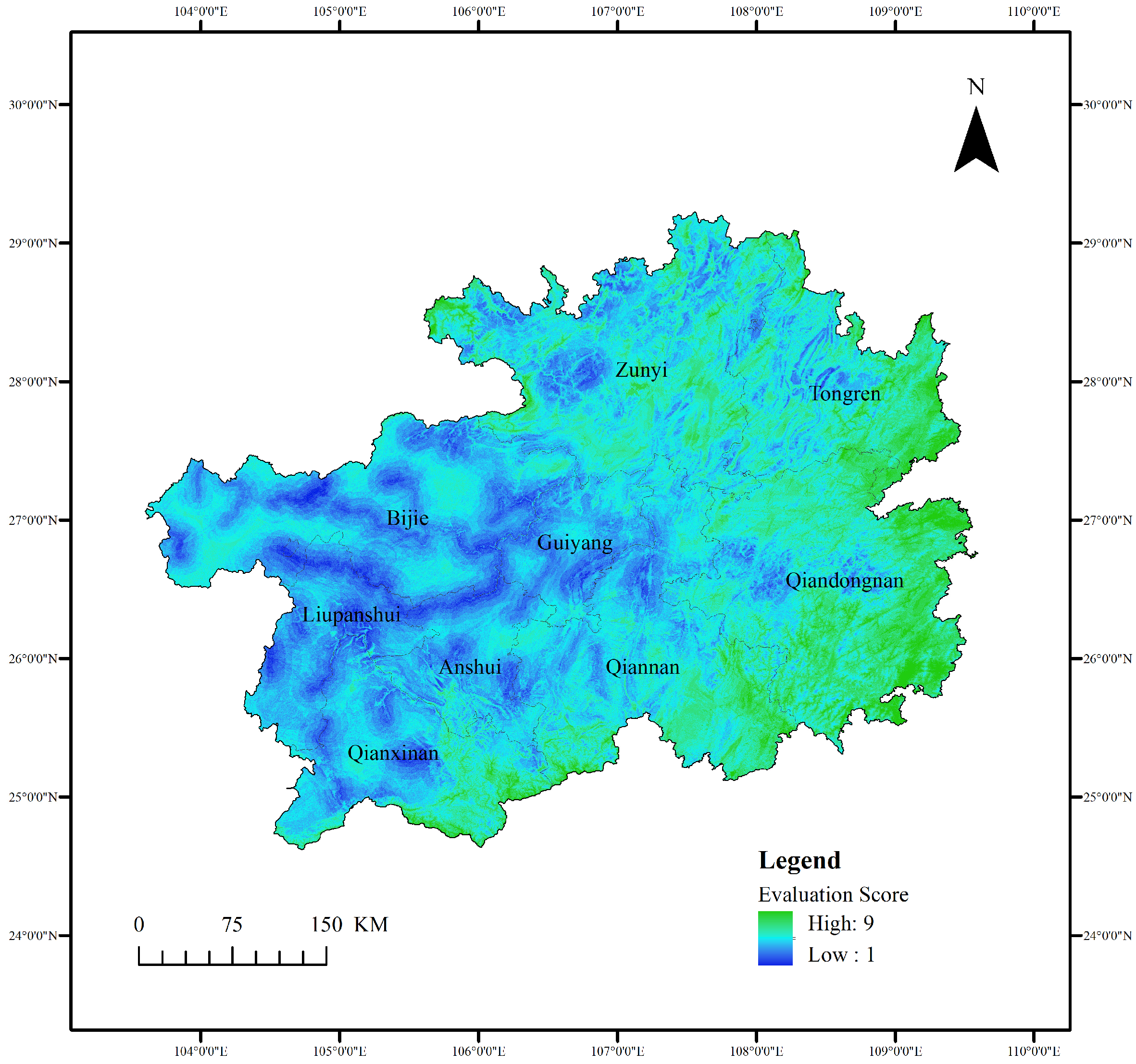
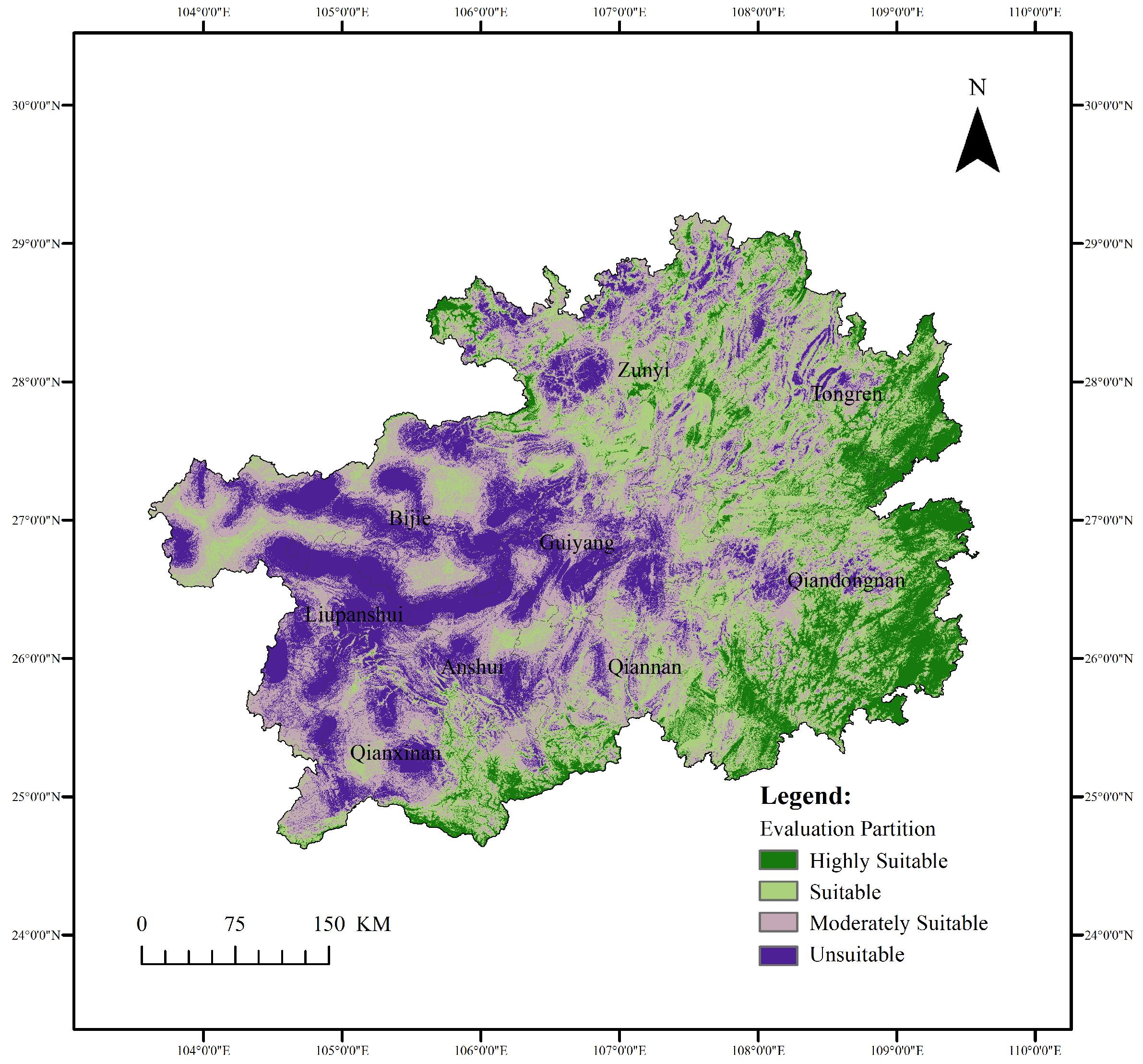
- Combining the influence factors constructed using Geodetector with the AHP method, a spatial assessment system for traditional villages in Guizhou was established. The assessment results divided the province into four zones: highly suitable, suitable, moderately suitable, and unsuitable. Highly suitable areas account for 13.82% of the area and include 41.22% of Guizhou’s traditional villages. These areas are primarily located in Qiandongnan and are characterized by low altitudes and low risk. Unsuitable areas account for 22.28% of the area but only include 7.66% of the villages. These areas are primarily located in the high-altitude areas of the Yunnan-Guizhou Plateau. Suitable and moderately suitable areas are more sparsely distributed, differing from each other in subtle differences in comprehensive assessment. Suitable areas have higher overall scores and generally demonstrate better geographical conditions or disaster resilience. Moderately suitable areas, on the other hand, have shortcomings in one or more of these conditions.
Author Contributions
Funding
Data Availability Statement
Acknowledgments
Conflicts of Interest
References
- Tianjin University Feng Jicai Institute of Literature and Art. Available online: https://fjcxy.tju.edu.cn/teaching.html (accessed on 20 August 2025).
- Liu, Y.D.; Zhang, Y.P.; Xu, X. Visual Analysis of Research on Traditional Miao Villages in Guizhou Based on Citespace. Archit. Creat. 2022, 05, 178–183. [Google Scholar]
- The State Council the People’s Republic of China. Available online: https://www.gov.cn/xinwen/2023-03/21/content_5747704.htm (accessed on 20 August 2025).
- Nie, X.; Wang, Q.; Wu, J.; Wang, H.; Chen, Z.; He, J. Effectively enhancing perceptions of cultural ecosystem services: A case study of a karst cultural ecosystem. J. Environ. Manag. 2022, 315, 115189. [Google Scholar] [CrossRef]
- World Heritage Glossary. Available online: https://whc.unesco.org/en/glossary/225 (accessed on 28 October 2025).
- Birnbaum, C.A. The Secretary of the Interior’s Standards for the Treatment of Historic Properties: With Guidelines for the Treatment of Cultural Landscapes; National Park Service Division of Publications: Washington, DC, USA, 1996. [Google Scholar]
- Zhang, Y.W.; Shu, Y.; Li, J. Exploring the Protection Paradigm of Traditional Village Cultural Landscapes Based on Isomorphic Characteristic Analysis. South. Archit. 2025, 9, 93–103. [Google Scholar]
- Giordano, S. Agrarian landscapes: From marginal areas to cultural landscapes—Paths to sustainable tourism in small villages—The case of Vico Del Gargano in the club of the Borghi più belli d’Italia. Qual. Quant. 2020, 54, 1725. [Google Scholar] [CrossRef]
- Ducros, H. The New Rural in Les Plus Beaux Villages de France: Heritage Preservation, Promotion and Valorization in the Post-agricultural Village. Ph.D. Dissertation, University of North Carolina, Chapel Hill, NC, USA, 2014. [Google Scholar]
- Di Fazio, S.; Modica, G. Historic rural landscapes: Sustainable planning strategies and action criteria. The Italian experience in the global and European context. Sustainability 2018, 10, 3834. [Google Scholar] [CrossRef]
- Sezer, E. Historical Assets Analysis in Heritage Sites for Cultural Landscape Management. Case Studies of Aristocratic Estates from Italy, France and Spain. Ph.D. Dissertation, Politecnico di Torino, Torino, Italy, 2020. [Google Scholar]
- Radzuan, I.S.M.; Fukami, N.; Yahaya, A. Cultural heritage, incentives system and the sustainable community: Lessons from Ogimachi Village, Japan. Geografia 2014, 10, 130–146. [Google Scholar]
- Chiang, Y.C.; Weng, P.Y.; Sato, N. The Preservation of Important Rural Japanese Cultural Landscapes—Considering the Warabino Paddy Field as an Example. J. Fac. Agric. Kyushu Univ. 2013, 58, 209–218. [Google Scholar] [CrossRef]
- Karle, S.; Carman, R. Digital Cultural Heritage and Rural Landscapes: Preserving the Histories of Landscape Conservation in the United States. Built Herit. 2020, 4, 5. [Google Scholar] [CrossRef]
- Robinson, E.B. Cultural Landscapes and Traditional Cultural Properties: A Study in Designation and Protection. Ph.D. Dissertation, Rutgers University, New Brunswick, NJ, USA, 2017. [Google Scholar]
- Deng, S.Q. Investigation Report on Gaobaibang Miao in Huishui, Guizhou. Guizhou Ethn. Stud. 1999, 1, 88–96. [Google Scholar]
- Smith, J.C. The Hmong, 1987–1995: A Selected and Annotated Bibliography; DIANE Publishing Company: Collingdale, PA, USA, 1998. [Google Scholar]
- Xu, K.; Chai, X.; Jiang, R.; Chen, Y. Quantitative Comparison of Space Syntax in Regional Characteristics of Rural Architecture: A Study of Traditional Rural Houses in Jinhua and Quzhou, China. Buildings 2023, 13, 1507. [Google Scholar] [CrossRef]
- Jia, S.; Isa, M.H.B.M.; Aziz, Z.B.A. Spatial Characteristics of Defensive Traditional Architecture in Multiethnic Village of Guangxi: Case Studies of Mozhuang Village and Guxietun Village. Front. Archit. Res. 2023, 12, 683–699. [Google Scholar] [CrossRef]
- Gao, J.; Wu, B. Revitalizing Traditional Villages Through Rural Tourism: A Case Study of Yuanjia Village, Shaanxi Province, China. Tour. Manag. 2017, 63, 223–233. [Google Scholar] [CrossRef]
- Li, Y.; Fan, P.; Liu, Y. What Makes Better Village Development in Traditional Agricultural Areas of China? Evidence from Long-Term Observation of Typical Villages. Habitat Int. 2019, 83, 111–124. [Google Scholar] [CrossRef]
- Li, X.; Zhang, F.; Hui, E.C.M.; Lang, W. Collaborative Workshop and Community Participation: A New Approach to Urban Regeneration in China. Cities 2020, 102, 102743. [Google Scholar] [CrossRef]
- Luo, Y.; Qi, L. Construction and Practice of a Conservation Plan Implementation Evaluation System for Historic Villages. J. Asian Archit. Build. Eng. 2019, 18, 351–361. [Google Scholar] [CrossRef]
- Zhang, H.; Li, B.H.; Dou, Y.D. The Characteristics and Mechanisms of the Evolution of Traditional Village Landscape Restoration Under the Power of Digital Technology: A Case Study of Zhangguying Village in Yueyang City, Hunan Province. J. Nat. Resour. 2024, 39, 1797–1814. [Google Scholar] [CrossRef]
- Yu, L.; Xie, D.; Xu, X. Environmental suitability evaluation for human settlements of rural residential areas in Hengshui, Hebei Province. Land 2022, 11, 2112. [Google Scholar] [CrossRef]
- Yang, G.; Wu, L.; Xie, L.; Liu, Z.; Li, Z. Study on the Distribution Characteristics and Influencing Factors of Traditional Villages in the Yunnan, Guangxi, and Guizhou Rocky Desertification Area. Sustainability 2023, 15, 14902. [Google Scholar] [CrossRef]
- Ford, D.; Williams, P.D. Karst Hydrogeology and Geomorphology; John Wiley & Sons: Hoboken, NJ, USA, 2007; pp. 25–31. [Google Scholar]
- China Population Census Yearbook 2020. Available online: https://www.stats.gov.cn/sj/pcsj/rkpc/7rp/indexch.htm (accessed on 25 August 2025).
- Traditional Chinese Villages Digital Museum. Available online: http://www.dmctv.cn (accessed on 15 December 2022).
- Geospatial Data Cloud. Available online: http://www.gscloud.cn (accessed on 28 June 2025).
- National Catalogue Service for Geographic Information. Available online: http://www.webmap.cn (accessed on 28 June 2025).
- National Earth System Science Data Centre. Available online: http://www.geodata.cn (accessed on 10 July 2025).
- Geographic Remote Sensing Ecological Network Platform. Available online: https://gisrs.cn/ (accessed on 16 July 2025).
- Gramacki, A. Nonparametric Kernel Density Estimation and Its Computational Aspects; Springer International Publishing: Cham, Switzerland, 2018; Volume 37, pp. 25–26. [Google Scholar]
- Li, J.; Wang, Y.; Bian, J.; Sun, X.; Feng, X. Health Risk Assessment of Groundwater in Cold Regions Based on Kernel Density Estimation–Trapezoidal Fuzzy Number–Monte Carlo Simulation Model: A Case Study of the Black Soil Region in Central Songnen Plain. Water 2025, 17, 2984. [Google Scholar] [CrossRef]
- Yuill, R.S. The Standard Deviational Ellipse; An Updated Tool for Spatial Description. Geogr. Ann. Ser. B Hum. Geogr. 1971, 53, 28–39. [Google Scholar] [CrossRef]
- Chen, Y.; Li, R. Spatial Distribution and Type Division of Traditional Villages in Zhejiang Province. Sustainability 2024, 16, 5262. [Google Scholar] [CrossRef]
- Jia, A.; Liang, X.; Wen, X.; Yun, X.; Ren, L.; Yun, Y. GIS-Based Analysis of the Spatial Distribution and Influencing Factors of Traditional Villages in Hebei Province, China. Sustainability 2023, 15, 9089. [Google Scholar] [CrossRef]
- Xu, X.; Genovese, P.V. Assessment on the Spatial Distribution Suitability of Ethnic Minority Villages in Fujian Province Based on GeoDetector and AHP Method. Land 2022, 11, 1486. [Google Scholar] [CrossRef]
- Su, X.; Zhou, H.; Guo, Y.; Zhu, Y. Multi-Dimensional Influencing Factors of Spatial Evolution of Traditional Villages in Guizhou Province of China and Their Conservation Significance. Buildings 2024, 14, 3088. [Google Scholar] [CrossRef]
- Foresman, T.; Luscombe, R. The second law of geography for a spatially enabled economy. Int. J. Digit. Earth 2017, 10, 979–995. [Google Scholar] [CrossRef]
- Wang, J.F.; Xu, C.D. Geodetector: Principle and Prospective. Acta Geogr. Sin. 2017, 72, 116–134. [Google Scholar] [CrossRef]
- Saaty, T.L. The Analytic Hierarchy Process: Planning, Priority Setting, Resource Allocation; RWS Publications: Columbus, OH, USA, 1990; pp. 37–49. [Google Scholar]
- Chen, P.; Li, C.; Chen, S.; Li, Z.; Zhang, H.; Zhao, C. Tea Cultivation Suitability Evaluation and Driving Force Analysis Based on AHP and Geodetector Results: A Case Study of Yingde in Guangdong, China. Remote Sens. 2022, 14, 2412. [Google Scholar] [CrossRef]
- Munier, N.; Hontoria, E. Uses and Limitations of the AHP Method: A Non-Mathematical and Rational Analysis; Springer International Publishing: Berlin, Germany, 2021; pp. 1–4. [Google Scholar]
- Aymen, A.T.; Al-husban, Y.; Farhan, I. Land suitability evaluation for agricultural use using GIS and remote sensing techniques: The case study of Ma’an Governorate, Jordan. Egypt. J. Remote Sens. Space Sci. 2021, 24, 109–117. [Google Scholar] [CrossRef]
- Guo, W.; Wu, D.F.; Li, Y.; Wang, F.X.; Ye, Y.Q.; Lin, H.W.; Zhang, C.F. Suitability evaluation of popular science tourism sites in university towns: Case study of Guangzhou university town. Sustainability 2022, 14, 2296. [Google Scholar] [CrossRef]
- Chen, T.; Zhang, S.; Chen, J.; Duan, J.; Zhang, Y.; Yang, Y. Spatial Distribution Characteristics and Cluster Differentiation of Traditional Villages in the Central Yunnan Region. Land 2025, 14, 1565. [Google Scholar] [CrossRef]
- Bao, X.; Yang, Y.; Qi, J.; He, Y. An Analysis of Spatial Distribution Characteristics and Driving Factors of Traditional Villages in the Loess Plateau. PLoS ONE 2025, 20, e0329356. [Google Scholar] [CrossRef]
- Wu, K.H.; Su, W.C.; Ye, S.A.; Luo, S.Q.; Wang, H.C. Study on the Spatial Pattern of Traditional Villages in Guizhou and the Identification of Influential Environmental Factors. Geogr. Geo-Inf. Sci. 2025, 41, 103–110. [Google Scholar] [CrossRef]
- Wu, K.H.; Su, W.C.; Jia, Z.Z.; Wang, H.C.; Ye, S.A.; Luo, S.Q. Spatial Distribution Pattern and Driving Forces of Tourist Destinations Based on GIS and Geodetector: A Case Study of Guizhou. Sci. Geogr. Sin. 2022, 42, 841–850. [Google Scholar] [CrossRef]
- Genovese, P.V.; Xu, X.; Wu, H.; Hao, D.; Wang, H. Assessment of Environmental Suitability for the Spatial Distribution of Minority Villages in Mountainous Areas—Taking Fujian Province as an Example. Land 2025, 14, 131. [Google Scholar] [CrossRef]
- Doyle, E.E.; Johnston, D.M.; Smith, R.; Paton, D. Communicating Model Uncertainty for Natural Hazards: A Qualitative Systematic Thematic Review. Int. J. Disaster Risk Reduct. 2019, 33, 449–476. [Google Scholar] [CrossRef]
- Beltramo, R.; Taglio, I.; Bonadonna, A. Designing Thematic Tourist Trails for Local Development: A Framework Based on Territorial Heritage. Land 2025, 14, 1943. [Google Scholar] [CrossRef]
- Islam, M.M.; Hasan, M.; Mia, M.S.; Al Masud, A.; Islam, A.R.M.T. Early Warning Systems in Climate Risk Management: Roles and Implementations in Eradicating Barriers and Overcoming Challenges. Nat. Hazards Res. 2025, 5, 523–538. [Google Scholar] [CrossRef]
- Yan, L.; Xu, J.B. The Success Factors of Community Events: A Case Study of the Village Super League in Rongjiang (China). Event Manag. 2024, 8, 883–894. [Google Scholar] [CrossRef]

| Name | Details | Data Source | Link |
|---|---|---|---|
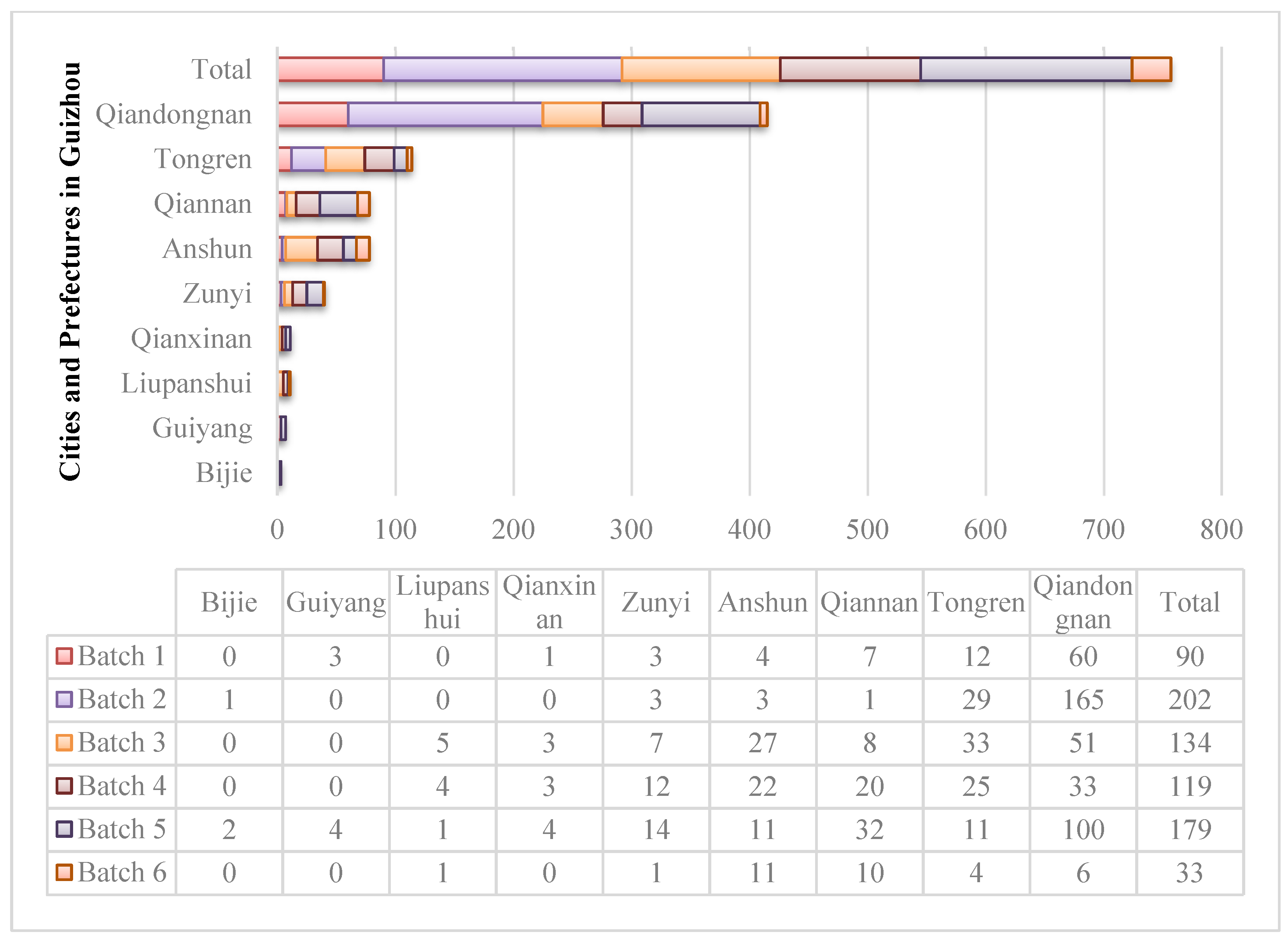
| Guizhou Traditional Villages [29] | 757 villages were announced by the China Traditional Village Protection and Development Research Centre from 2012 to 2020 through six batches. | Traditional Chinese Villages Digital Museum | http://www.dmctv.cn, accessed on 15 December 2022 |
| DEM [30] | A dataset that uses a set of digital arrays to represent ground elevation information, used to describe the shape and relief of the earth’s surface, in 30 m × 30 m. | Geospatial Data Cloud | http://www.gscloud.cn, accessed on 28 June 2025 |
| Provincial Boundaries [31] | The boundary of Guizhou Province, used to clip DEM and other calculated boundaries in ArcGIS. | National Catalogue Service for Geographic Information | http://www.webmap.cn, accessed on 28 June 2025 |
| River Distribution [32] | DEM can generate river data through hydrological analysis in ArcGIS, and combine it with river distribution information to complete the processing work. | National Earth System Science Data Centre | http://www.geodata.cn, accessed on 10 July 2025 |
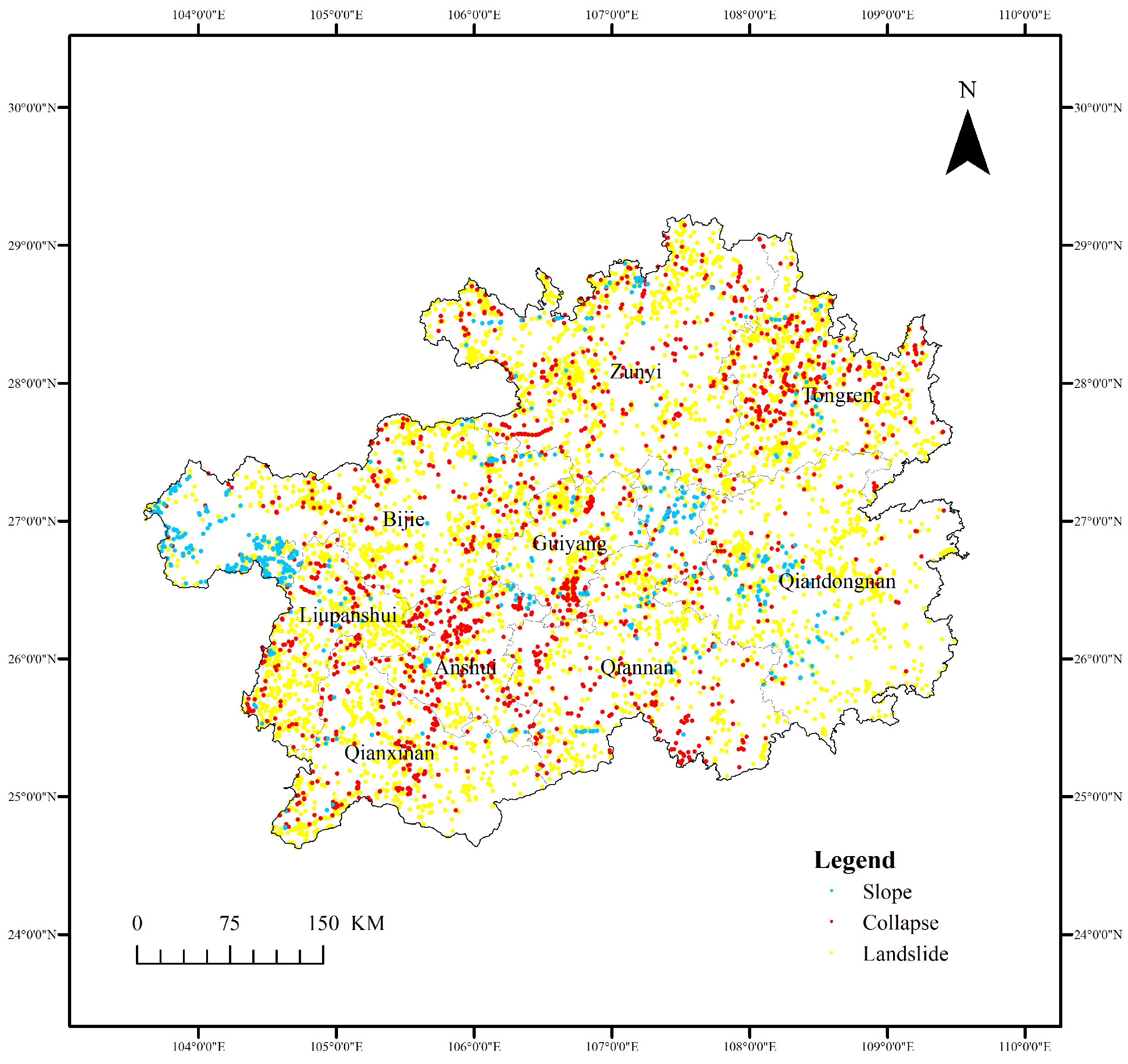
| Disasters Data [33] | Data from Guizhou Province were selected from China’s disaster data, which includes data on slope, collapse, and landslide disasters. | Geographic Remote Sensing Ecological Network Platform | https://gisrs.cn/, accessed on 16 July 2025 |
| Batch | Coordinate X (km) | Coordinate Y (km) | Major Axis (km) | Minor Axis (km) | Orientation (°) |
|---|---|---|---|---|---|
| 1 | 839.09 | 2920.43 | 131.96 | 95.91 | 119.21 |
| 2 | 837.22 | 2943.81 | 75.77 | 107.75 | 163.20 |
| 3 | 764.39 | 2961.75 | 197.03 | 113.90 | 58.34 |
| 4 | 771.50 | 2957.57 | 186.17 | 137.74 | 53.72 |
| 5 | 801.43 | 2919.95 | 141.96 | 117.69 | 106.59 |
| 6 | 727.94 | 2922.82 | 186.71 | 98.05 | 68.90 |
| All | 800.99 | 2939.81 | 150.14 | 125.17 | 73.32 |
| A | B | C | D | E | |
|---|---|---|---|---|---|
| q value | 0.034685 | 0.023618 | 0.003702 | 0.026732 | 0.025567 |
| A | B | C | D | E | |
|---|---|---|---|---|---|
| A | 0.034685 | 0.087198 | 0.050285 | 0.083504 | 0.151300 |
| B | 0.087198 | 0.023618 | 0.046250 | 0.069009 | 0.069839 |
| C | 0.050285 | 0.046250 | 0.003702 | 0.055496 | 0.068983 |
| D | 0.083504 | 0.069009 | 0.055496 | 0.026732 | 0.135186 |
| E | 0.151300 | 0.069839 | 0.068983 | 0.135186 | 0.025567 |
| A | B | C | D | E | |
|---|---|---|---|---|---|
| A | 1 | 4 | 5 | 3 | 3 |
| B | 1/4 | 1 | 4 | 1/2 | 1/2 |
| C | 1/5 | 1/4 | 1 | 1/5 | 1/5 |
| D | 1/3 | 2 | 5 | 1 | 2 |
| E | 1/3 | 2 | 5 | 1/2 | 1 |
| Category | Weight (%) | Indicator | Weight (%) | Reference Standards | Level | Score |
|---|---|---|---|---|---|---|
| Geographical Factors | 60.33 | Altitude (m) | 43.59 | <499 | 5 | 9 |
| 499–694 | 4 | 7 | ||||
| 694–878 | 3 | 5 | ||||
| 878–1132 | 2 | 3 | ||||
| 1132–1755 | 1 | 1 | ||||
| Slope (°) | 11.94 | <10 | 5 | 9 | ||
| 10–15 | 4 | 7 | ||||
| 15–20 | 3 | 5 | ||||
| 20–25 | 2 | 3 | ||||
| 25–44 | 1 | 1 | ||||
| Aspect (°) | 4.80 | 0 | 3 | 5 | ||
| 0–22.5, 337.5–360 | 1 | 1 | ||||
| 22.5–67.5, 292.5–337.5 | 2 | 3 | ||||
| 67.5–112.5, 247.5–292.5 | 3 | 5 | ||||
| 112.5–157.5, 202.5–247.5 | 4 | 7 | ||||
| 157.5–202.5 | 5 | 9 | ||||
| Disaster Factors | 39.67 | Flood Sensitivity | 22.29 | Extremely High Sensitivity | 5 | 9 |
| High Sensitivity | 4 | 7 | ||||
| Medium Sensitivity | 3 | 5 | ||||
| Low Sensitivity | 2 | 3 | ||||
| Very Low Sensitivity | 1 | 1 | ||||
| Landslide Sensitivity | 17.38 | Extremely High Sensitivity | 5 | 9 | ||
| High Sensitivity | 4 | 7 | ||||
| Medium Sensitivity | 3 | 5 | ||||
| Low Sensitivity | 2 | 3 | ||||
| Very Low Sensitivity | 1 | 1 |
| Range Divisions | Classification |
|---|---|
| 6.0172–9.0000 | Highly Suitable |
| 4.7416–6.0172 | Suitable |
| 3.5956–4.7416 | Moderately Suitable |
| 1.0000–3.5956 | Unsuitable |
| Classification | Percentage of Area | Number of Traditional Villages | Percentage of Traditional Villages |
|---|---|---|---|
| Highly Suitable | 13.82% | 312 | 41.22% |
| Suitable | 27.46% | 254 | 33.55% |
| Moderately Suitable | 36.44% | 133 | 17.57% |
| Unsuitable | 22.28% | 58 | 7.66% |
Disclaimer/Publisher’s Note: The statements, opinions and data contained in all publications are solely those of the individual author(s) and contributor(s) and not of MDPI and/or the editor(s). MDPI and/or the editor(s) disclaim responsibility for any injury to people or property resulting from any ideas, methods, instructions or products referred to in the content. |
© 2025 by the authors. Licensee MDPI, Basel, Switzerland. This article is an open access article distributed under the terms and conditions of the Creative Commons Attribution (CC BY) license (https://creativecommons.org/licenses/by/4.0/).
Share and Cite
Liu, Y.; Zhang, Y.; Genovese, P.V. An Integrated Geographical-Disaster Factor Approach for Sustainable Management: Case Study of Traditional Villages in Karst Mountains. Land 2025, 14, 2219. https://doi.org/10.3390/land14112219
Liu Y, Zhang Y, Genovese PV. An Integrated Geographical-Disaster Factor Approach for Sustainable Management: Case Study of Traditional Villages in Karst Mountains. Land. 2025; 14(11):2219. https://doi.org/10.3390/land14112219
Chicago/Turabian StyleLiu, Yidan, Yiping Zhang, and Paolo Vincenzo Genovese. 2025. "An Integrated Geographical-Disaster Factor Approach for Sustainable Management: Case Study of Traditional Villages in Karst Mountains" Land 14, no. 11: 2219. https://doi.org/10.3390/land14112219
APA StyleLiu, Y., Zhang, Y., & Genovese, P. V. (2025). An Integrated Geographical-Disaster Factor Approach for Sustainable Management: Case Study of Traditional Villages in Karst Mountains. Land, 14(11), 2219. https://doi.org/10.3390/land14112219


