Article

Deep Water Ports as a Trigger for Ongoing Land Use Conflicts? The Case of Jade Weser Port in Germany

1
Working Group “Co-Design of Change and Innovation”, Leibniz Center for Agricultural Landscape Research e.V., 15374 Müncheberg, Germany
2
Research Institute for Regional and Urban Development, 44135 Dortmund, Germany
*
Author to whom correspondence should be addressed.
Land 2025, 14(10), 2009; https://doi.org/10.3390/land14102009
Submission received: 9 September 2025 / Revised: 28 September 2025 / Accepted: 30 September 2025 / Published: 7 October 2025

Abstract

Coastal areas are under intense pressure worldwide because diverse stakeholders rely on coastal resources, and the supply of land is highly limited. Coast-dependent economic activities like transportation and logistics infrastructure in the Jade Bay, Germany, have experienced extensive demand for land. The situation is more interesting because national parks encircle the seaport. Understanding the complex seaside–landside dynamics following the development of Jade Weser Port is crucial for promoting sustainability, as massive development exceeds existing spatial capacity. However, a comprehensive framework to assess land use conflicts when dealing with infrastructure development in sensitive coastal areas is often missing. We analyze the origin of land use developments and the planning process at different administrative levels by retracing land use changes from 1970 to 2015 using a time series of satellite images, analyzing planning documents, and examining realized activities. We look for an embedding of transport infrastructure development and its feedback on land use. As a consequence of land use conflicts, these land system dynamics create winners and losers across multidisciplinary aspects. Our findings reflect interdisciplinary aspects which discuss both societal changes and the constellation of inadequate planning approaches to address the complexity of coastal land use. The degree to which these activities cause land use conflicts depends on institutional settings, especially the consistency of ICZM and infrastructure planning.

1. Introduction

Coastal areas are under intense pressure from development worldwide [1]. Numerous and diverse stakeholders rely on coastal resources, but their supply of land is highly limited. Coastal-dependent economic activities, such as transportation and logistics infrastructure, are caused by international trading activities and compete with touristic and residential development as well as with environmental and agricultural interests [2,3,4,5]. Infrastructure development is a crucial factor for large-scale land use change, as it challenges the sensitivity of coastal areas. Owing to their multifunctional landscapes, coastal areas have experienced extensive demand for land [4]. In addition, the rapid increase in seaport-related industries and logistics conflicts with the maintenance of ecosystem services [6,7]. Understanding the complex seaside–landside dynamics and the different factors contributing to conflicts is crucial for promoting sustainability, since massive development often expands and exceeds existing spatial capacity. These land system dynamics create winners and losers across many scales as a consequence of land use conflicts [8].
Interestingly, protected areas such as national parks often encircle and share direct borders with seaports. This is the case in the Jade Weser Port project in Germany, which is used as a case study. Moreover, German planning regulations have been met by adopting integrated coastal planning and management (ICPM), integrated coastal zone management (ICZM), and integrated coastal zone planning (ICZP) [9], anticipating a dynamic process of sea–land interface development and (potential) land use conflicts [10,11]. Unfortunately, with the installation of a transport network system, including a motorway feeder road and rail connection, we observe land use changes along the corridor of the Jade Bay area within ten years after the completion of the seaport and anticipate massive future land use changes. As a consequence of the emerging seaport industry, transport network development, which is the main backbone of its industries, increases rapid activities around the national park, triggering serious environmental threats and exceeding existing spatial capacity. The degree to which these activities cause land use conflicts and unsustainable solutions depends on institutional settings, especially comprehensive planning procedures and sectoral (infrastructure) planning activities [11]. However, since studying land use is strongly related to land governance [8], observing a comprehensive instrument of the integrated coastal zone management (ICZM) and infrastructure planning in coastal areas is often missing [12]. New assessment frameworks for coastal areas including ICZM and transport planning can help to gain a better understanding of land use conflicts and its driving factors, since it defines specific boundary conditions [13,14].
The following case study offers the opportunity to better understand the interacting driving forces, existing governance and possible solutions for reducing land use conflicts. As a consequence, conclusions can be drawn about the development of coastal zones in the future.
This paper reflects interdisciplinary aspects which discuss both societal changes and the constellation of planning approaches to address the complexity of transport networks and coastal land use by analyzing two aspects, creating an applicable research strategy:
  • What are the main drivers for generating demand for land use change and land use conflicts, especially along coastlines with sensitive areas?
  • What are the main institutional settings, especially those that focus on the interrelations between transport and the land use cycle?
We analyze the origin of land use developments and the planning process at different administrative levels by retracing fundamental land use changes and designations from 1970 to 2015 using a time series of satellite images and analyzing planning documents and realized activities. Moreover, we look for an embedding and explanation of transport infrastructure development and its feedback on land use.
Corresponding to the ongoing complexity of coastal land use in the Jade Bay area, it offers new contributions to the knowledge by focusing on long running impacts of infrastructure planning [15] as well as the tele-coupling of interregional connection [16] amid weak land use consistency. It is also crucial to have a better understanding of how co-design-methods can be integrated into coastal development plans and nature protection frameworks [17], thus assessing commitment to innovation in decision-making processes [18] by accommodating multilevel and inter-regional actors’ collaboration [19] under ethical practices [8].

2. Theoretical Background

The empirical analysis of land use changes must adopt existing knowledge about underlying cause–effect models, as shown in Figure 1. One generally accepted complex model for explaining the interrelation between land use and infrastructure development that fits the situation to be analyzed is the transport–land use feedback cycle (TLUFC) model. It describes a circular process of infrastructure development, specifically of transportation networks, and land use change, ultimately increasing the demand for more infrastructure development [20], as long as no intervention occurs. Moreover, land use adapts to new opportunities that emerge from transportation infrastructure, as the latter positively affects the immediate accessibility of an area. This so-called shifting land governance phenomenon is a reaction to shifts in value and land systems where governance is shifting from ‘territorial’ toward ‘flow-centered’ arrangements that target particular flows of resources or goods [21] due to increasing challenges by global flows, which connect distant places through international trade, foreign investment and the movement of people [22]. As the intensity of activities related to these land uses increases, existing infrastructure reaches its capacity limits and needs to be expanded, resulting in a displacement of environmental burdens from a tele-coupling perspective [23].
The cycle explains the interplay between transport infrastructure development and the impacts on land use. Following transport infrastructure cycle logic, Bertolini [24] noted that in regions with accessibility-oriented strategies, new areas outside designated plans are under development pressure. As a consequence, new infrastructure is developed. This often addresses geographically sensitive areas. However, this becomes an opportunity for the planning authority to adapt to future transportation needs to facilitate new locations with a specific economic agenda. In this context, integrating accessibility infrastructure and land use into a more sustainable landscape management is a specific task [25,26,27].
In terms of the importance and impact of transport infrastructure, investments in new transport infrastructure and the development of regional accessibility bring more advantages for promoting new locations [28,29,30]. This triggers the investors’ preference toward location in the context of industrial development. According to Spiekermann and Wegener [31], the quality of the transport infrastructure addresses the carrying capacity and logistic connectivity. In the socioeconomic context, transport network development can provide better access to the efficiency of logistic and industrial activities [32,33]. In addition, it promotes economic growth and regional competitiveness [30]. It is often new investment in transport infrastructure that can improve not only logistics accessibility but also trigger changes in spatial development patterns [34]. Moreover, previous studies have indicated that land use planning plays an important role in logistics activities as a problem-solving instrument [35,36,37]. However, land use conflicts often occur where territorial land governance is used as the default paradigm [38] such as the current status in the German planning mechanism [39,40]. According to Müller et al. [41] and Verburg et al. [25], the advantage of using flow-centered land governance in the land use planning process enables the specific designation of protected areas to be better protected from the intervention of spatial development plans.

3. Case Study Approach, Hypotheses, and Methods for Analysis

In the following, we used a case study approach to determine the relationships among phenomena, context, and people by capturing the context and lived reality on the ground [42]. We used a similar approach to analyze the deep-water seaport of Patimban, Indonesia [43].

3.1. Case Study Context

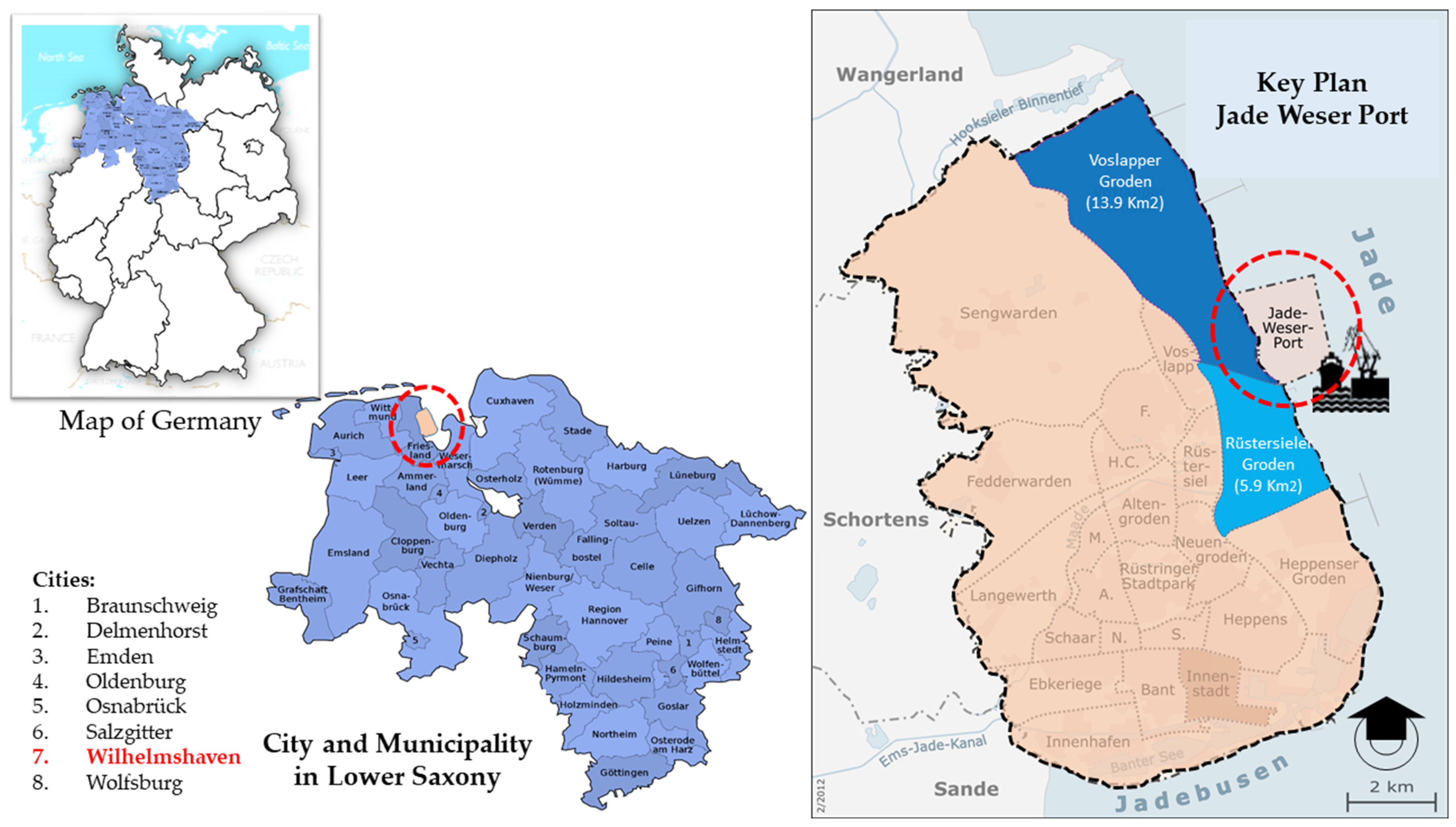
Jade Weser Port is the only deep seaport in Germany situated in the Jade Bay in Wilhelmshaven, which is a town that is considered the central hub of the German federal state of Lower Saxony (see Figure 2). The long history of military harbor use was followed by the idea of developing an economic hub for decades. With the installation of Jade Weser Port, industrial development has merged several port locations along 35 km of German North Sea coastal areas, such as Elsfleth, Brake, and Nordenham, into a unified coastal and port region. Today, Wilhelmshaven serves as one of the economic and cultural centers of the North Sea coast with recreational possibilities with a population of approximately 90,000 inhabitants [44]. Figure 2 shows the location of Jade Weser Port and its strategic position on the north coast of Germany in Lower Saxony. Operating on approximately 170 ha of newly reclaimed land, 63% of the Jade Weser Port’s area is allocated to the container terminal area, 30% to port-related industries and services, and 7% to transportation areas [45].
Owing to the growth of the world economy and increasing globalization, which also affects the German economy, the idea of designing and constructing a deep-water seaport in Germany was initiated by the government of Lower Saxony in collaboration with the federal State of Bremen in the early 2000s. Thus, Jade Weser Port has been designed to represent Germany’s central sea hub for giant vessels. According to statistics describing the cargo-handling activities at Jade Weser Port in 2015 and 2016, ship traffic increased by 12%, while rail traffic reached 36%. As expected by the stakeholders, the increased ship volume created a high demand for new investment. The port’s location coincides with Europe’s first oil port with long-distance pipelines, which was developed at Jade Bay in the early 1970s, making the Jade Bay area the backbone of mineral oil distribution and turning it into a major zone of the chemical industry and power generation [46].
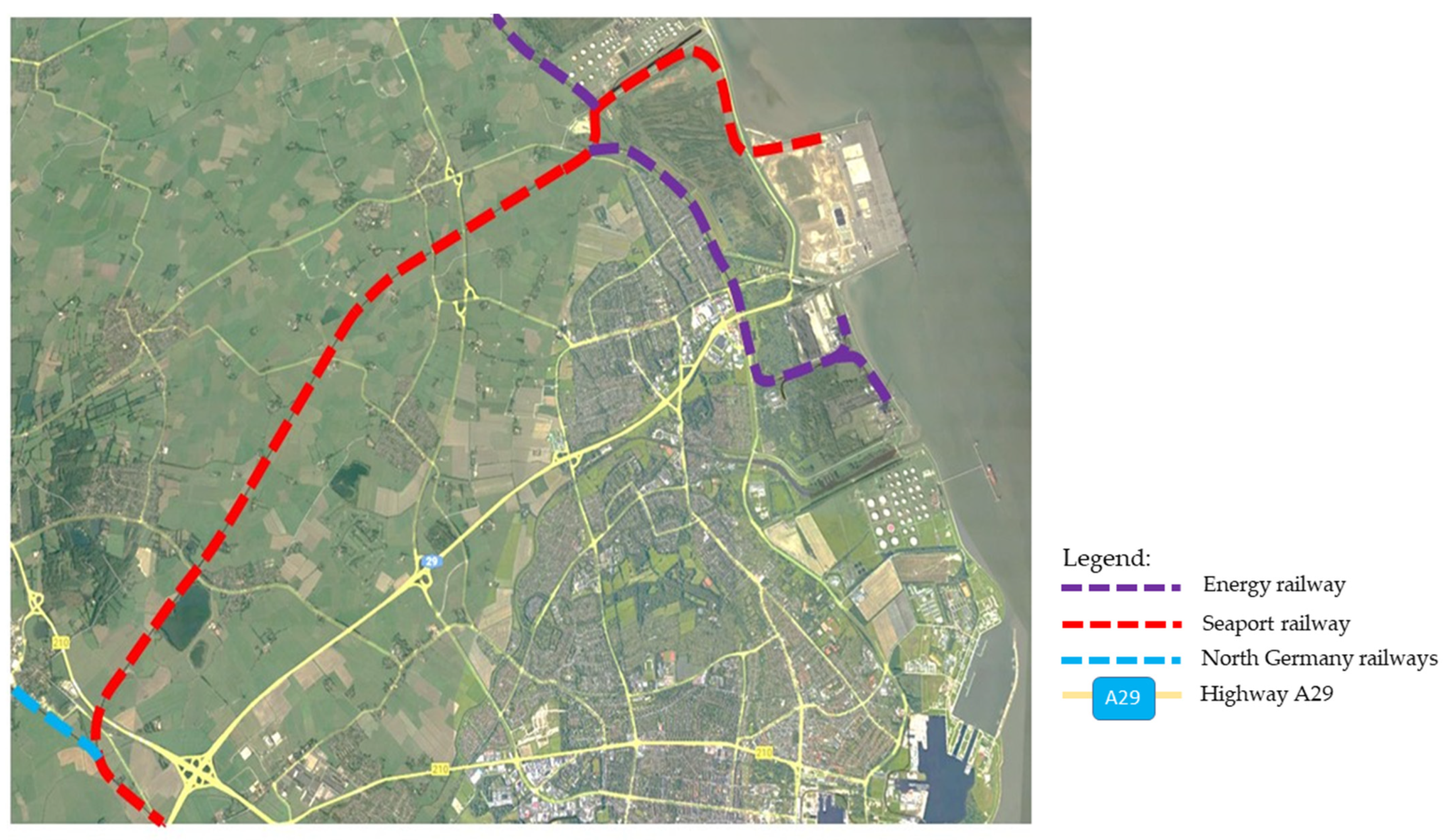
In 2009, the fundamental transportation network was built and is still being expanded by the German Railway Company (Deutsche Bahn, Berlin, Germany) cargo service. It directly connects surrounding industrial estates in Lower Saxony and other federal states to the logistic village at Jade Weser Port (see Figure 3). In addition, Jade Weser Port is linked to Germany’s arterial road network via the Lower Saxony embankment and a direct extension of the German motorway A29, reducing traffic congestion affecting the city of Wilhelmshaven [33]. Upon the completion of motorway A31 in December 2004, the highway expansion improved regional connectivity, especially between Jade Weser Port and the North Rhine–Westphalia region [47].
The potential for competition in land use is high because of the characteristics of the Jade Weser area. Until 2002, the entire area was dominated by grasslands, intensive agriculture, wood production forests, and conservation areas [48,49]. Dominated by lowland and inland marshes along almost the entire coastline, the Jade Bay area has the potential to be developed into a marine tourism area [46]. With more than 80% of the area being state-owned land, land tenure does not represent a major property issue related to investment programs in the Jade Bay. However, an essential singularity of Jade Weser Port is that it is encircled by the Wadden Sea National Park, which is composed of different zones of nature protection to maintain natural dynamic processes in the Wadden Sea, particularly coastal activities. The Government of Lower Saxony made a commitment to nature protection in the Jade Bay in January 1986 through the declaration of the Wadden Sea National Park [50].

3.2. Hypotheses

We developed two hypotheses on the basis of existing knowledge to analyze the potential and actual impacts of seaport development and the related network infrastructure and discuss institutional settings, including governance arrangements.
As Dalgetty et al. [51] and Swain [52] described, hypotheses allow researchers to guide investigations and seek adequate strategies to answer research questions. Reflecting on our main research focus (see above), we formulate two hypotheses to guide our investigation and justify the assumed causal relationship in this case. The hypotheses are based on current scientific knowledge and previous experience, including other case studies that enable an explanation of the empirical findings as well as the generalization of the results. They can be formulated in such a way that falsification is possible.
Our Hypothesis 1 is as follows: Seaside development in the port region generates ongoing demand for land use change and is a consequence of land use conflicts, especially along coastlines with sensitive areas.
For Hypothesis 1, we looked at deep seaport development and network infrastructure-related seaports in the Jade Bay area. Since seaport development and transport networks are interwoven, much evidence shows the impacts of expanding transportation networks that create constant feedback cycles [20,24,34]. In a specific context, the economic activities served by sea trading are more transport-generated [53], whereas logistics transportation plays the most fundamental role in shaping economic growth [54].
We consider seaport development a significant source of emerging land use conflicts, as it is an inherently anthropogenic creation that extends seaside–landside functions [2]. It has been emphasized that the current debate in this field, including the locational preference for large-scale infrastructural projects, represents an especially contentious land use conflict with serious environmental consequences [26,55]. In theory and practice, an ongoing positive feedback loop between transport infrastructure and artificial land development can be observed [56].
The need to integrate transport and land use policies to achieve more sustainable urban development and avoid land use conflicts is widely recognized in scientific and professional communities. The example of Rotterdam, the most prominent harbor city in the Netherlands, indicates the effectiveness of integrating two aspects through the joint accessibility design framework, which addresses both accessibility needs and current land use policy debates [57]. The concept of integration is derived from four critical goals: (1) improving social cohesion, (2) enhancing the economic competitiveness of a city to attract more jobs, (3) increasing the variety of living environments, and (4) sustaining growth by reducing demand for land. For each goal, the planning authority determines the spatial capacity that citizens deem most relevant and important and then prioritizes it accordingly. From several relevant cases, it is important to stress that integrating transport and land use into coastal planning could be important concerning a specific planning goal in which conflict among actors can be minimized.
To summarize, the deep seaport, one of Germany’s largest infrastructure projects, is a major source of emerging land use conflicts, which we believe is the original motivation behind the revision of land use planning.
Our Hypothesis 2 is as follows: If desired, institutionally-based interventions can avoid negative feedback loops in the transport–land use cycle.
For Hypothesis 2, we looked at planning activities and governance approaches to the decision-making process before seaport development and land use planning ratification, which allows investment-related seaports to enter coastal areas. Instead of a more stringent land use planning approach, large-scale infrastructure projects often respond more pragmatically [58]. This results in ineffective land use planning, which requires spatial planning to be more flexible with investments [59]. In theory and practice, an ongoing positive feedback loop between transport infrastructure and artificial land development can be observed [26,55,56]. Interventions such as comprehensive spatial planning and infrastructure planning offer an opportunity to reduce land use change toward artificial land and to avoid land use conflicts in the long run [6,11].
However, the frequent ratification of spatial plans has indirectly weakened their effectiveness as control instruments for intervening in locational preferences to prevent future land use conflicts [60]. We observe the existence of plans that reduce land use change and protect sensitive areas [61]. The effectiveness of spatial planning is low, as future scenarios and prediction instruments are unable to be consistently strict with the designation of land use plans, which aim to control ongoing and future land development, anticipate land use conflicts, and protect nature.
Next, we use all the hypotheses as the basis of our analysis to answer the research questions. Through these hypotheses, we develop a research design for data collection and analytical methods. Subsequently, we present the results of our analysis, which, reflected in the discussion and conclusion, constitute the key insights of this paper.

3.3. Material and Methods

To examine the interconnection between land use changes and the origin of land use conflicts in the Jade Bay Area, four major sources were used to collect data and information. The methodology consisted of the following: (1) document analysis based on a series of spatial planning documents, coastal zone management and the project master plan, (2) GIS analysis according to the time series of satellite images to elaborate the actual land cover changes, (3) semi-structured interviews conducted with groups of experts from the universities, research center, and environmental watch, which represent their knowledge regarding the planning process and the project implementation, and (4) site observation aimed at having a clear understanding of the project implementation. Combining all of these methods provided an overview of the historical milestone, stages of land use change, and the process that ultimately led to the current situation on the ground.

3.3.1. Document Analysis

We analyzed planning documents relevant to land use planning and regulation and other documents related to the Jade Weser Port project. The analyzed documents constitute the official land use plan, which comprises national spatial planning, federal state spatial planning, regional planning, and local planning, as well as the national park and master plan of Jade Weser Port (see Table 1).
An analysis of the planning documents before the Jade Weser Port construction aimed to determine how change processes occurred in the planning documents and which land uses were designated in the Jade Bay area from 1985 to 2020. It is also essential to observe how far spatial changes have occurred since the spatial plan was first drafted in 1973 and how significantly the area was transformed thirty years later.
The spatial analysis also focuses on expanding transportation infrastructure to support energy activities and the effect on spatial distribution. From the existing spatial plans at the four governmental levels (Table 1), we distinguished which areas have rapidly transformed into built environments due to the expansion of transport infrastructure from those that have developed less or not at all due to limited accessibility. We analyzed the spatial conditions before and after seaport development, as these two significant aspects are prominent in the correlation and consistency of planning implementation. Thus, the new deep seaport is the landmark for ratifying the spatial plan to adapt Wilhelmshaven to future global logistic trends and investments. The extent to which Jade Weser Port plays a key role in activities in the region is crucial. This aspect led us to use the spatial plan ratified after the seaport operation as a turning point to identify real problems in the Jade Bay area.

3.3.2. GIS Analysis

To observe the actual land use situations, we require detailed preferences to identify patterns and forms of land use allocation that may be triggered by transportation network development. GIS is one of the most valuable applications [62] for land use suitability mapping and helps analyze patterns of land use changes. Satellite imagery is a powerful mean of monitoring land use change at high temporal resolution. Digital data, therefore, enable the accurate computing of various land use categories and have become essential for monitoring urban expansion and land use studies [63].
In this study, as illustrated in Figure 4, change detection focuses on identifying differences in the state of human activities by observing them at different times. Change detection in land use and land cover is performed on a temporal scale according to the class definitions with specific characteristics of coastal zones before seaport construction between 1985 and 2015.
Analyzing the time series of satellite images from 1985 to 2015 is also intended to clarify the consistency of spatial plans and the implementation of integrated coastal zone management with reality on the ground. Additionally, expanding new investment areas is often associated with massive logistics infrastructure development that connects industrial estates to logistic hubs such as seaports.
This analysis is chosen because of the different methods used in various applications and the context of their use. We consider distinguishing between two notions: the physical state of the Earth’s surface in terms of the natural environment, such as vegetation, and artificial structures, such as buildings within the Jade Bay area. Since land use itself is the human employment of a land cover type, it involves the condition in which the attributes of the land are determined and the purpose for which the land is used.
The interpretation’s output is expected to clarify six major categories: energy plant and oil storage, seaport, nature-protected zone, industrial area, settlements, agriculture, and the influence of the logistic transportation network on those significant land uses.
Using satellite images, our observations also focus on the expansion of two major transport infrastructures: the regional train network and the national highway route. These infrastructures have created a new logistic corridor in the northern region of Germany, serving direct connectivity to Jade Weser Port [45].
This study examines the impacts of two major logistics network expansions associated with seaport activities and how these factors may increase the demand for land and influence location preferences for new investments [57,64].

3.3.3. Interviews

Through semi-structured interviews, we collected data for this study. The respondents represent specific actor groups of differing institutional levels relevant to the case study context. They represent (1) public institutions such as university experts and research centers, (2) NGOs, and (3) private actors. It was not possible to obtain answers from planning authorities.
All respondents were interviewed using open-ended questions, covering three major steps: (1) the formal planning process, where project governance, planning changes and persistency, actors, institutions, and interests are studied, and (2) the decision-making process, in which planning actors and national park are linked in land use discussions and their impact on conservation and coastal landscape elements is determined. Open-ended questions have been used by researchers and university experts with our assumption that this method may trigger the respondents to have a greater cognitive perspective regarding the Jade Weser Port project, nature protection, and its impacts after construction began.

3.3.4. Site Observations

The purpose of site observations in the Jade Bay area was to better understand the actual land use situation and to control satellite image classifications on the ground. One crucial aspect was looking at accessibility and connectivity from surrounding neighborhood regions to the seaport area. Additionally, we investigated the existence of the Wadden Sea National Park and its role in the entire area related to seaport activities.
Considering the materials and activities we have utilized, the Jade Bay area has a unique landscape character that serves as a regional gateway and an essential national biosphere for wildlife. The regional situation is characterized by strong contrasts, such as strengthening Germany’s position in global value chains while continuing nature protection. Overall, site observations revealed the need to focus more on transportation networks and the future expansion of built areas, which may lead to land use conflicts along the corridor of the Jade Bay area.
The results are presented below and are structured into two major aspects. (1) The impacts of seaport infrastructure, especially along coastlines with sensitive areas, are derived from ongoing land use changes in which seaside development generates land use conflicts. (2) Negative feedback on transport and land use can be avoided by reinventing governance and the land use planning process. These two major aspects summarize the hypotheses explained in the Results section. Both demonstrate how the development of transportation networks can affect spatial planning or, on the contrary, how adaptive spatial planning can attract more investment, leading to increased demand for rail-based logistics networks and toll roads.

4. Results

The analysis carried out in this study focused on the cause–effect relationship between key issues in the hypotheses and key factors of analysis, as shown in Table 2. The key issues in the hypotheses are as follows: (1) demand for land on the seaside and landside; (2) vulnerable coastal landscapes; (3) prediction of land use conflicts; and (4) the loop cycle effect. The key elements of analysis are (1) real land use changes; (2) real changes in transport infrastructure before and after two major forms of logistic accessibility are developed and expanded onto coastlines; (3) changes in nature protection, in which the impacts of the Jade Weser Port and logistic infrastructure on the Wadden Sea National Park are discussed; and (4) changes in planning and regulation, consisting of time series of spatial plans at different governmental levels and the change process of spatial planning from non-built-up areas.

4.1. Demand for Land on Seaside and Landside Areas

Figure 5 illustrates the situation between 1995 and 2010, when the entire area of Voslapper Groden and Rüstersieler Groden was primarily designated for coal-based energy production and oil stations [50]. For more than 40 years, offshore platforms have been operating to facilitate the docking of oil tankers and coal vessels at these two stations with the railway network as the significant logistic infrastructure. Until recently, sea access has been used for energy transportation in Wilhelmshaven since the first operation in the early 1970s. Before the seaport development in 2012, the city of Wilhelmshaven was one of the vital energy hubs in Germany [50]. In addition, the industrial area has been allocated very limited space due to the lack of a transportation network except for oil distribution [65].
Rüstersieler Groden is the most prominent location, and the demand for land has increased threefold compared with that in the last three decades. Within approximately 5.9 km2, around 57% of the area has been occupied by logistics uses and container terminals [66], coal power plants, and the PVC industry. The increase in demand was driven by the operation of Jade Weser Port in 2012.
Apart from allocating industrial land use in the spatial plan, private agencies have secured 300 ha areas that have not been touched thus far [47]. Out of a total of 160 ha, approximately 60 ha are still available. Since 2020, the freight village has concluded a ground lease agreement for 20 ha that may extend outside the seaport boundary. Many investors are reviewing their strategies to hold land and real estate as safety reserves for future expansion [47]. Another approach applies where a land leasing scheme is available to attract investment. Instead of owning the property, investors could propose a preferable location under the long-term scheme, which would last between 10 and 30 years. Jade Weser Port offers a 75-year lease scheme that benefits customers who temporarily use the property with no obligation to return it until the lease term expires. This seaport offers an advanced logistic hub that can serve giant vessels on the sea and has an integrated land banking scheme to support logistics industries in the seaside area [47].
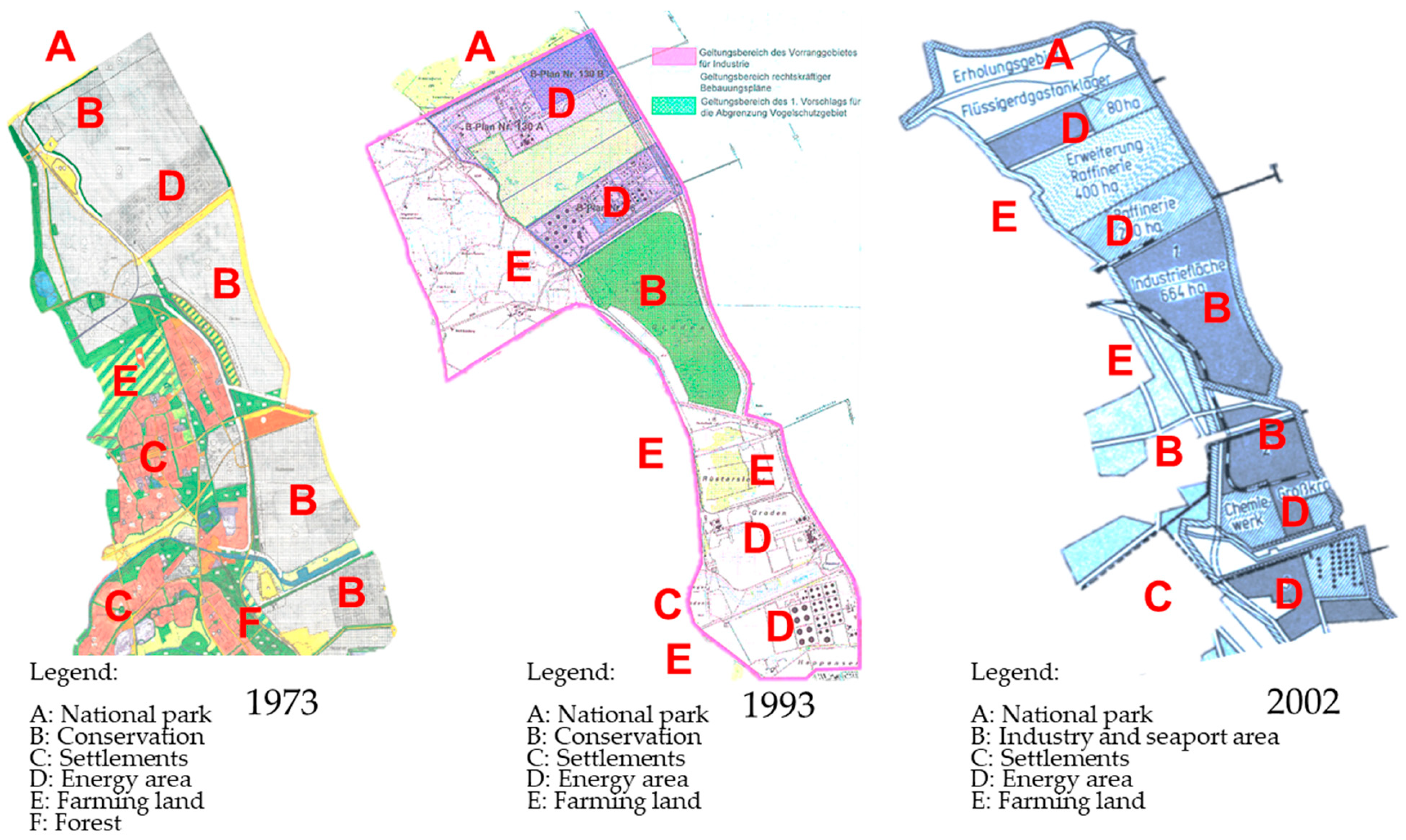
Figure 6 illustrates the footprint of planning milestones in the Jade Bay area. From the beginning, the coastal landscape development of the Jade Bay was not designated for industrial regions but rather to provide a conservation zone with the possibility for ecotourism and small-scale enclaves for energy-based industries, where human interaction and demand for land were limited [50,65]. This can be seen in the 1973 spatial plan document, where the gray area is integral to the Wadden Sea conservation zone. In this plan, the entire area of the Jade Bay consists of grassland with a minor area of intensive agriculture [50,66]. Accessibility and logistics infrastructure to the coastline were still very limited, as indicated by the land use data from 1993, and even in the 2002 version. Spatial change did not occur until late 2002, when a railroad line was built connecting the edge of the Jade Bay, where the gas and oil terminal site is located [66].
The ongoing expansion of transportation networks to industrial zones and seaports has been growing since the beginning of 2010, as port service capacity increases and the number of industries expands [66]. This has threatened sensitive areas and made nature-protected areas more vulnerable. Until 1995, the demand for railway expansion increased due to improved oil storage capacity, where distribution used rail-based transportation. The new LNG terminal uses a pipeline system that can reduce transportation and space [66]. In addition, in 2012, the reclamation and construction process for the deep-water seaport in Voslapper Groden was completed. The high interdependency of land development on the logistics network was evident when highway A29 was not yet in place at the beginning of the Jade Bay development. Railway-based logistics was the only option for oil and energy transport activities. In short, the railway network expanded to the coastline, resulting in a high threat to natural protection.
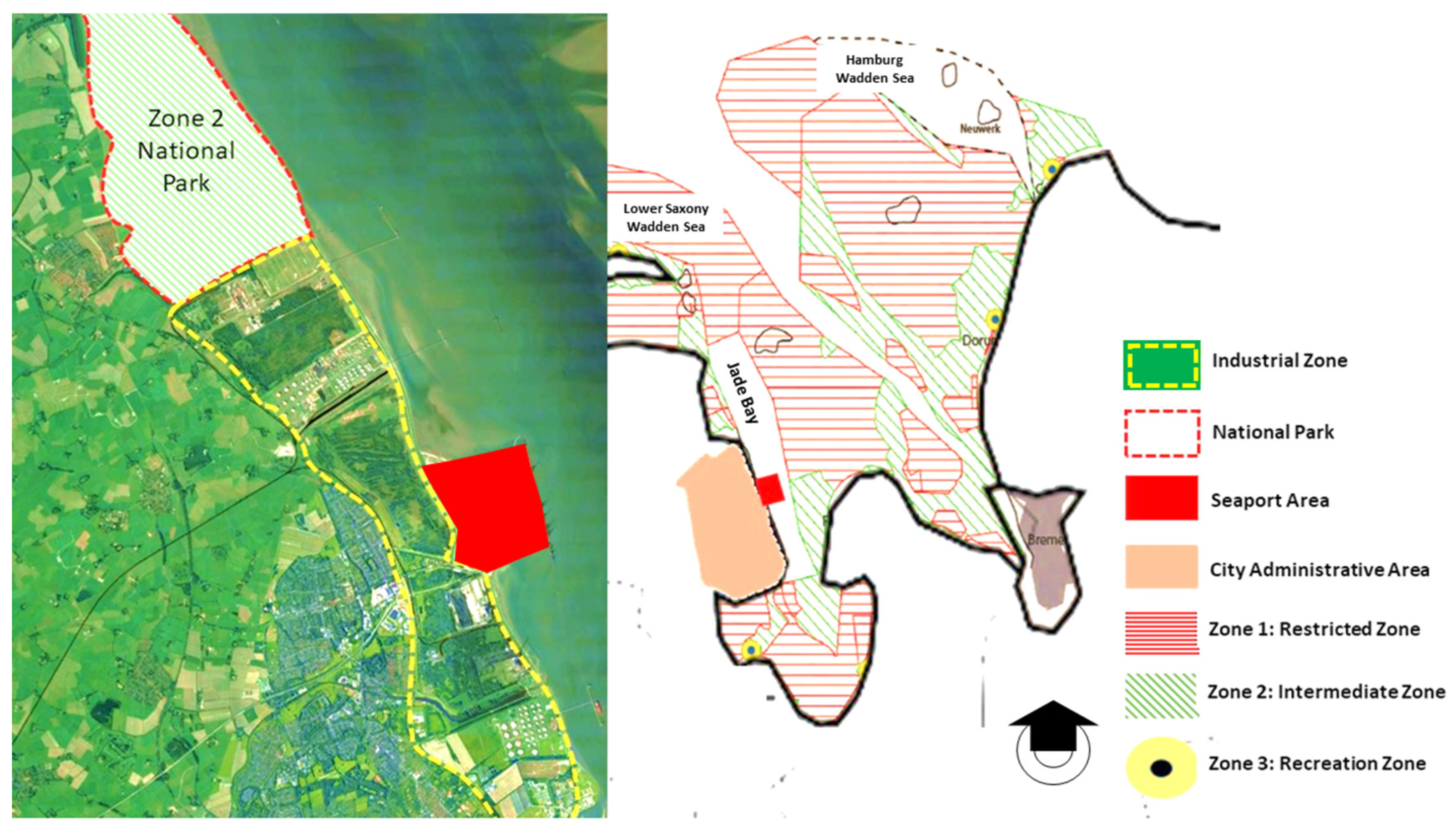
Serious consequences arose when the new double-track network extended near Zone 2, which is the intermediate area of the national park. Zone 2 is the interface between the highly restricted area and the outside of the national park. In this zone, only recreation activities are allowed within certain time periods, and these must have no impact on the flora and fauna (Figure 7). Although the track is still inside the designated location, future increases in new investment in the industrial area could hamper the existence of a coastal landscape and highly protected zone in the Wadden Sea National Park (Zone 1) [65].

4.2. Planning Processes and Feedback Loops

The results of transport infrastructure analysis reveal two aspects: (1) how planning authorities respond to the need for logistic transportation and (2) how spatial planning adapts spatial capacity and prepares for future demand on land.
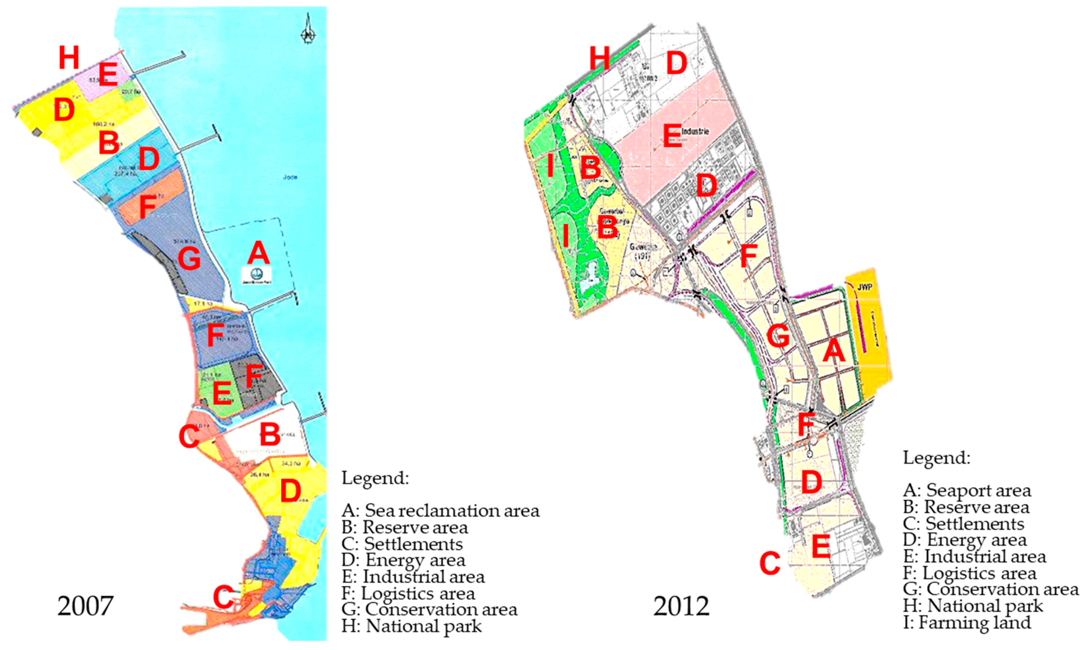
Figure 8 shows how planning ratification became one of the crucial issues in Jade Weser Port. The 2007 version of the land use plan revealed a change in regional orientation from oil- and energy-based development to the seaport and logistic regions [66]. Since then, Jade Weser Port has been marked as Wilhelmshaven’s new center of orientation and regional identity with the seaport serving as the logistic backbone.
Moreover, a contrasting situation occurred in the regional spatial plan for 2012 (RROP), which emphasized a new spatial structure to specifically allocate massive amounts of industry. The new structure strengthened a new regional identity for Wilhelmshaven city not only as the energy center but also as a seaport and logistics region. Figure 9 illustrates the regional spatial plan (RROP) for 2012 and 2014, in which the entire area of Jade Weser Port was designated for industrial-related seaports. The availability of spatial instruments has allowed the city of Wilhelmshaven to develop an industrial zone with advanced accessibility for transporting goods from and to Jade Weser Port. Reflecting on the satellite images from 2015 (see Figure 6) and site observations from 2021, the spatial structure of the Jade Bay area was transformed into a more investment-friendly area, where every spot was commercialized and well connected by railway networks and highways. The current regional spatial plan reflects the future trend and provides opportunities for new investors to use this competitive advantage as a preference for selecting a new location. Consequently, this ratification has opened the area within the designated seaport perimeter and expanded to the area outside. This phenomenon increased the demand for new investment and reached the limit of spatial capacity. The planning authority has ratified its spatial plan to adapt to market demand. The investment proposals that the city government receives become an opportunity for the planning authority to expand the logistics transportation network, resulting in a transport–land use cycle effect in the Jade Weser Port area.
Figure 9 explains how the sequence of spatial planning ratifications has been intended to adapt to transnational logistics, in which the area has met the foreign direct investment needs in recent decades. The establishment of the industrial area in the land use plan for 2012 cannot be separated from the Jade Weser Port megaproject development plan, which is supported by the massive development of transport networks, such as railways and highways.
However, the ongoing change process through land use ratification leads to a weak regulatory function in controlling the location preference of investors. Since spatial capacity becomes more limited in the future, the nature-protected area northwest of the seaport area will continue to be threatened. The changes in logistics transportation planning have driven land use conflicts between seaport and industrial areas and the Wadden Sea National Park [65]. The ongoing logistic infrastructure development is witnessing an increasing rate of land use development, which diverges significantly from the nature protection agenda.
Coastal land use transformation has occurred since the early 1970s. When the first train network was developed, it connected the hinterland with energy production plants (oil stations and coal plants) and created new logistics corridors in Wilhelmshaven.
Despite spatial planning and nature protection aiming toward sustainable coastal land management, planning instruments remain weak in controlling the high demand for land. In this case, seaport infrastructure and logistics activities continue to grow as the new corridor significantly reconnects the hinterland to the seaport. Transport infrastructure is inevitably the sole driving factor attracting new industrial estate [50,66], which, by 2014, had established itself in a 30-hectare area within the Jade Weser Port boundary. This trend is set to continue in the future, expanding out of the existing seaport zone and potentially converting agricultural land, as evidenced by the construction of an LNG gas storage center in the Voslapper Groden area starting in 2021.
The construction of the transport network in the Jade Bay area has, on the one hand, improved logistics services and increased trade flows [66]. However, on the other hand, the negative loop effect occurs as the existing area increasingly loses its carrying capacity because high investment is not proportional to land availability [50]. To date, no institutional intervention has effectively intervened in the supply–demand cycle of land demand. The Federal Waterways Engineering and Research Institute [66] describes how high land demand arose as the railway network expanded alongside the increase in new investment. This phenomenon has been recognized by the city planning authority [50]. Since the spatial plan accommodates the seaport plan, land control mechanisms are left behind in project implementation. Planning interventions under specific institutions with a more integrated task between spatial planning and land governance will effectively control ongoing demand and future spatial conflicts [34,67]. Specifically, the lack of institutional intervention can be seen from the increase in new enclaves within industrial areas and the tendency toward agglomeration out of designated areas or the current industrial zone.
From the analysis of land use changes in satellite images and the range of consistency in the implementation of spatial planning through site observations and interviews, the following assumptions can be concluded about the situation in the Jade Bay area before and after the construction of the deep seaport:
Hypothesis 1.
The existence of an adequate transportation network has increased the high demand for land for new investment, especially in logistics activities. The relationship between the two is interdependent, where neither is more assertive or more dominant. At the beginning of the establishment of the industrial estate in the Jade Bay, the industrial estate encouraged the construction of the rail network. However, after the logistics infrastructure was completed, established, and expanded into a double track, the area developed faster than before. The railroad extension toward the coastline is feared not only because it is no longer intended solely for transporting goods and logistics but also due to its potential to encourage the expansion of passenger access for tourism. This is due to the high demand for tourism development in the Jade Bay. In addition, the trend of rail-based distribution further threatens the conservation area boundary because of the need to expand the terminal capacity. The more railways developed, the greater the threat to sensitive areas in the Jade Bay.
Hypothesis 2.
The transport network–land use constellation has placed the Jade Bay area under high pressure, as the demand for land for investment has increased while land capacity has been limited. This happens because no institution has special authority to regulate coastal development. Thus, the high complexity of problems and potential spatial violations are not addressed by effective institutional regulation but are instead controlled by the market and investment.
The results show that on the basis of transport network feedback to the land use, we have demonstrated high acceptance and great confirmation of both hypotheses; (1) land use change in coastal areas is a consequence of high demand for land mainly driven by direct and indirect effects of the rapid transport network development, (2) ineffective spatial regulation leads to massive development near protected areas, conflicting with the maintenance of essential coastal ecosystems, forcing the limit of spatial capacity and threatening sustainable coastal zone management.

5. Discussion

Overall and to reflect the conflicts in the Jade Bay area, from the perspective of the transport–land use feedback cycle and the implementation of integrated coastal zone management (ICZM), the conflicts emerged due to four major sources: (1) the territorial land governance model that is used in planning process failed to limit expansion of the transport network and built area in nature-protected areas, (2) socioecological changes in coastal land management, e.g., in land use intensity remain still behind the seaport project priority, which is associated with key parameters of transport network development as the vital logistics activities, (3) inconsistency of specific land use in different governmental levels, (4) in terms of accelerating project implementation, top–down and political power has a lagged distribution of authority from local government to manage coastal land management behind project goals. Several of these factors have been individually outlined as posing frequent problems in land governance processes and ICZM in the global north by previous researchers [68,69,70]. However, Germany, one of the European Union countries that integrates ICZM instruments in coastal spatial planning [12], has struggled to strengthen systems-based thinking in implementing those four aspects in land use planning while maximizing flexibility and adaptability when dealing with investments and solving conflicts [71]. Therefore, an additional example from another European country allows for a comparison with an example of transport network and ICZM integration. Elaborations on how two factors can effectively resolve land use conflicts can be found in the deep seaport developments of Klaipeda, Lithuania. This case study exemplifies additionally, in a specific and comprehensive context, how those four factors are interrelated and interact in their potential to deal with land use conflicts. It can be seen as a good practice example for improving the governance processes in the Jade Weser Port.
Klaipeda Deep Seaport is situated on the east coast of the Baltic Sea and serves as the country’s main sea trade site [72]. The reclamation of land for seaport expansion is the solution to land shortages; on the other hand, it also creates a nexus of transport and logistics that triggers the development of large-scale industrial estates [73]. Massive railway development to improve logistic services from outside the seaport into the new terminals, followed by the high demand for land and seaport-related investments, flourished along the bay area of Curonian Spit.
Figure 10 shows how the existing interface of Klaipeda Port threatens the nature-conserved area of Curonian Lagoon. Exposing transport networks outside the seaport is a serious environmental threat [73]. Despite high-risk impacts on nature-protected areas, the integration of ICZM and strong consistency in delineating interface zones in land use planning have balanced new reclamation efforts with Curonian National Park. The city government of Klaipeda started by creating an institutional intervention that brings together university experts, environmentalists, scientists, urban planners, and seaport authorities to develop a shared vision, synchronized spatial regulations, zoning delineation, and an investment plan under a single coordination desk. The most prominent role is held by the Klaipeda State Seaport Authority, a state-owned enterprise responsible for controlling land development, expansion, and reclamation, ensuring that it does not exceed the national park boundary. Although Klaipeda is not the best example of implementing ICZM when dealing with megaproject infrastructure and protecting coastal areas, its integrative and participatory approach clearly demonstrates an effective strategy for resolving land use conflicts, as shown by the negative loop cycle effect during and after reclamation and transport network development.
Reflecting on the implementation of ICZM in Klaipeda, Lithuania, and the land use plan for the specific coastal zone in the Jade Bay, Germany, highlights the knowledge gap concerning the consistency of regulation and on-the-ground implementation simultaneously. Despite the precondition of ICZM, legal and regulatory aspects of managing land and political and socioeconomic contexts [74] are already in place, and the political process and economic agenda are more dominant than the application of ICZM instruments influencing the decision-making process. Since the beginning, the development of a new deep seaport in the Jade Bay has lacked consistency considering five aspects of ICZM, especially environmental protection, geographical boundaries, and spatial capacity, resulting in high pressure on the Wadden Sea National Park, which shares direct borders with the seaport. Moreover, the time series of land use planning that the three governmental levels have arranged is not aligned with the spatial capacity and land availability, especially considering the impact of the completion of transport network development. The increased number of investments exceeding the designated area clearly demonstrates that ICZM and spatial planning, as operational tools and control instruments for ensuring sustainable coastal land use, have failed to manage megaproject development, despite the deep seaport concept being designed to reduce the negative impacts of limited spatial capacity on the landside.
With respect to participation, ICZM mandates that the planning integration process must involve the participation and cooperation of all stakeholders to assess the societal goals in a given coastal area. This aims to take appropriate action to meet these objectives. However, the implementation of ICZM in the Jade Bay lacks participation to collect common visions toward the existence of the national park from different actors. The land use plans that have been integrated into the ICZM principles by far have issues in terrestrial identification and assessment before land reclamation, program preparation according to coastal planning, project implementation, and evaluation related to conservation and nature protection [65]. In addition, the ongoing land use changes represent different agendas at different governmental levels. This emerging phenomenon is derived from diverse interests and possible disputes between city and federal governments concerning the protection of the Jade Bay area and the attraction of new investments. In the end, the interference of top–down policies has made it challenging to implement rigorous planning when other policies are mixed with ICZM policies [75].
Overall, from both cases, the following sections will explain these effects in more detail:
(1) Land use dynamics as a consequence of land use conflicts are complicated at the spatial scale and derive major challenges of high demand for land after seaport development. If previous studies have shown predominantly single patterns of land use changes [76], e.g., deforestation–reforestation [77], or agricultural land abandonment–new agricultural land [78], the Jade Weser Port offered a novelty for future assessments of multiple patterns of land use changes that are integrative across multiple driving factors such as deep seaport and global trade cycles, land systems and environmental and resource scarcity, and deep seaport and anthropogenic climate change, which are not well understood at present [76].
(2) ICZM, as the most crucial guideline for managing coastal areas, often lags behind investment initiatives and responds to the spatial plan after the project is underway [79]. In the end, the ratification of spatial planning regulations at all administrative levels was carried out as a pragmatic response to the situation that the previous planning instruments could not control [43,80]. After the seaport began operation, planning regulations were no longer prepared as an anticipatory scenario for future spatial changes but instead became a tool for compromise among many interested actors. The results explicitly show the importance of coastal zone management consistency [81] and spatial planning enforcement [82]. The current planning regulations are focused on the continued development of transportation networks. Consequently, the corridor of the Jade Bay area will inevitably continue to be threatened by investment activities.
The important recommendations for the further development of the integrated coastal zone and transport network into spatial planning systems are embedded in international debates [20] and regard the analysis and further development of coastal spatial planning approaches [83]. First and foremost, the authors call for a more complex analysis of tele-coupling the human–environment [84] shifting paradigm from territory governance, which is a more self-centered area, into flow-centered land governance activities that strengthen all land use with landscape protection being the most prominent instrument in coastal land use management [21,81].

6. Conclusions and Outlook

Land use changes in the Jade Bay are a consequence of land use demands mainly driven by direct and indirect effects of the rapid transport network development. Meanwhile, land use conflicts are defined as a divergence of actors’ interests and contrasting perspectives toward ongoing demand for land use change in relation with industrial estate policies. This case shows a high acceptance of the hypothesis above where the integrative complexity of thematic interaction between massive transport network development and strong actors’ interest as the original motivation behind the revision of land use planning follow the recommendations made for land system science [85]. The intense political pressures behind investment demands drive this phenomenon. From the authors’ perspective, the Jade Weser Port project is a game changer in regional land use planning that offers complex nexus structures in a top–down approach when dealing with coastal land use management [12], which are also reflected more generally in the tele-coupling approach [84]. Meanwhile, the frequent ratification of spatial plans has indirectly weakened their effectiveness as control instruments to prevent future land use conflicts [60]. Viewing governance debates, the recommendations show ways toward co-design approaches of multilevel policy with the key strategy being managing megaprojects with the local government’s capacity to balance the interests between national park protection and megaproject initiatives in the long run to reduce land use conflicts.
In addition to the significant findings of this research, our research did not include the importance of land tenure and ownership as factors in the decision-making process, as land tenure is not an issue in Germany, whereas in other nations, these factors have crucial impacts. However, in the future, considering land ownership and land tenure in planning could help address different driving factors more adequately.
For further research necessities, the limited cooperation of local planning authorities during the coronavirus pandemic led to poor qualitative data collection regarding coastal planning policy and how formal and informal governance is manifested in the decision-making process [86]. It is also crucial to deep dive into the power relation at all administrative levels [87] and test the existing hierarchical control into more interactive governance [88] when meeting top–down political intervention.

Author Contributions

Conceptualization, R.S. and T.W.; methodology, R.S.; software, R.S.; validation, R.S., T.W.; formal analysis, R.S.; investigation, R.S.; resources, T.W.; data curation, R.S.; writing—original draft preparation, R.S.; writing—review and editing, T.W.; visualization, R.S.; supervision, T.W.; project administration, T.W.; funding acquisition, T.W. All authors have read and agreed to the published version of the manuscript.

Funding

This research was funded by the German Ministry for Research, Technology, and Space (BMFTR), ReGerecht KFZ 033L205. The APC was funded by the Research Institute for Regional and Urban Development.

Data Availability Statement

The interview data presented in this study are available on request from the corresponding author. The data are not publicly available due to privacy.

Conflicts of Interest

The authors declare no conflict of interest.

References

  1. Micheli, F.; Niccolini, F. Achieving Success under Pressure in the Conservation of Intensely Used Coastal Areas. Ecol. Soc. 2013, 18, 19. [Google Scholar] [CrossRef]
  2. Felsenstein, D.; Lichter, M.; Ashbel, E. Coastal congestion: Simulating port expansion and land use change under zero-sum conditions. Ocean Coast. Manag. 2014, 101, 89–101. [Google Scholar] [CrossRef]
  3. Small, C.; Nicholls, R.J. A global analysis of human settlement in coastal zones. J. Coast. Res. 2003, 19, 584–599. [Google Scholar]
  4. Neumann, B.; Ott, K.; Kenchington, R. Strong sustainability in coastal areas: A conceptual interpretation of SDG 14. Sust. Sci. 2017, 12, 1019–1035. [Google Scholar] [CrossRef]
  5. Bello, F.G.; Lovelock, B.; Carr, N. Constraints of community participation in protected area-based tourism planning: The case of Malawi. J. Ecotourism 2017, 16, 131–151. [Google Scholar] [CrossRef]
  6. Plieninger, T.; Draux, H.; Fagerholm, N.; Bieling, C.; Bürgi, M.; Kizos, T.; Kuemmerle, T.; Primdahl, J.; Verburg, P.H. The driving forces of landscape change in Europe: A systematic review of the evidence. Land Use Policy 2016, 57, 204–214. [Google Scholar] [CrossRef]
  7. Dunford, M.; Yeung, G. Port–Industrial Complexes and Regional Development. In International Encyclopedia of Human Geography, 2nd ed.; Kobayashi, A., Ed.; Elsevier: Oxford, UK, 2020; pp. 271–280. ISBN 978-0-08-102296-2. [Google Scholar]
  8. Global Land Program. Telecoupling of Land Use Systems. 2025. Available online: https://glp.earth/our-science/themes/telecoupling-land-use-systems (accessed on 14 April 2025).
  9. Gee, K.; Kannen, A.; Glaeser, B.; Sterr, H. National ICZM strategies in Germany: A spatial planning approach. In Managing the Baltic Sea; Schernewski, G., Loser, N., Eds.; Coastline Reports; EUCC: Warnemünde, Germany, 2004; Volume 2, pp. 23–33. [Google Scholar]
  10. Kannen, A.; Burkhard, B. Integrated Assessment of Coastal and Marine Changes Using the Example of Offshore Wind Farms: The Coastal Futures Approach. GAIA—Ecol. Perspect. Sci. Soc. 2009, 18, 229–238. [Google Scholar] [CrossRef]
  11. Von Der Dunk, A.; Grêt-Regamey, A.; Dalang, T.; Hersperger, A.M. Defining a typology of peri-urban land-use conflicts—A case study from Switzerland. Landsc. Urban Plan. 2011, 101, 149–156. [Google Scholar] [CrossRef]
  12. Alterman, R.; Pellach, C. Regulating Coastal Zones: International Perspectives on Land Management Instruments; Taylor & Francis: Abingdon, UK, 2021. [Google Scholar]
  13. Jouili, T.A.; Allouche, M.A. Impacts of seaport investment on the economic growth. Promet-Traffic Transp. 2016, 28, 365–370. [Google Scholar] [CrossRef]
  14. Notteboom, T. Economic Analysis of the European Seaport System; Report for the European Sea Ports Organisation; ITMMA, University of Antwerp: Antwerp, Blegium, 2009. [Google Scholar]
  15. Kasraian, D.; Maat, K.; Stead, D.; Van Wee, B. Long-term impacts of transport infrastructure networks on land-use change: An international review of empirical studies. Transp. Rev. 2016, 36, 772–792. [Google Scholar] [CrossRef]
  16. Liu, J.; Herzberger, A.; Kapsar, K.; Carlson, A.K.; Connor, T. What is telecoupling? In Telecoupling: Exploring Land-Use Change in a Globalised World; Palgrave Macmillan: Cham, Switzerland, 2019; pp. 19–48. [Google Scholar]
  17. Liu, J.; Dietz, T.; Carpenter, S.R.; Taylor, W.W.; Alberti, M.; Deadman, P.; Redman, C.; Pell, A.; Folke, C.; Ouyang, Z. Coupled human and natural systems: The evolution and applications of an integrated framework: This article belongs to Ambio’s 50th Anniversary Collection. Theme: Anthropocene. Ambio 2021, 50, 1778–1783. [Google Scholar] [CrossRef] [PubMed]
  18. Franzke, C.L.; Ciullo, A.; Gilmore, E.A.; Matias, D.M.; Nagabhatla, N.; Orlov, A.; Paterson, S.K.; Scheffran, J.; Sillmann, J. Perspectives on tipping points in integrated models of the natural and human Earth system: Cascading effects and telecoupling. Environ. Res. Lett. 2022, 17, 015004. [Google Scholar] [CrossRef]
  19. Kapsar, K.; Frans, V.F.; Brigham, L.W.; Liu, J. The metacoupled Arctic: Human–nature interactions across local to global scales as drivers of sustainability. Ambio 2022, 51, 2061–2078. [Google Scholar] [CrossRef] [PubMed]
  20. Wegener, M.; Fuerst, F. Land-Use Transport Interaction: State of the Art. SSRN J. 2004, 1434678. [Google Scholar] [CrossRef]
  21. Sikor, T.; Auld, G.; Bebbington, A.J.; Benjaminsen, T.A.; Gentry, B.S.; Hunsberger, C.; Izac, A.-M.; Margulis, M.E.; Plieninger, T.; Schroeder, H. Global land governance: From territory to flow? Curr. Opin. Environ. Sustain. 2013, 5, 522–527. [Google Scholar] [CrossRef]
  22. Cotta, B.; Coenen, J.; Challies, E.; Newig, J.; Lenschow, A.; Schilling-Vacaflor, A. Environmental governance in globally telecoupled systems: Mapping the terrain towards an integrated research agenda. Earth Syst. Gov. 2022, 13, 100142. [Google Scholar] [CrossRef]
  23. Boillat, S.; Gerber, J.-D.; Oberlack, C.; Zaehringer, J.G.; Ifejika Speranza, C.; Rist, S. Distant interactions, power, and environmental justice in protected area governance: A telecoupling perspective. Sustainability 2018, 10, 3954. [Google Scholar] [CrossRef]
  24. Bertolini, L. From “streets for traffic” to “streets for people”: Can street experiments transform urban mobility? Transp. Rev. 2020, 40, 734–753. [Google Scholar] [CrossRef]
  25. Verburg, P.H.; Crossman, N.; Ellis, E.C.; Heinimann, A.; Hostert, P.; Mertz, O.; Nagendra, H.; Sikor, T.; Erb, K.-H.; Golubiewski, N. Land system science and sustainable development of the earth system: A global land project perspective. Anthropocene 2015, 12, 29–41. [Google Scholar] [CrossRef]
  26. Müller, D.; Munroe, D.K. Current and future challenges in land-use science. J. Land Use Sci. 2014, 9, 133–142. [Google Scholar] [CrossRef]
  27. Verburg, P.H.; Erb, K.-H.; Mertz, O.; Espindola, G. Land System Science: Between global challenges and local realities. Curr. Opin. Environ. Sustain. 2013, 5, 433–437. [Google Scholar] [CrossRef]
  28. Lee, J.K. Transport infrastructure investment, accessibility change and firm productivity: Evidence from the Seoul region. J. Transp. Geogr. 2021, 96, 103182. [Google Scholar] [CrossRef]
  29. McCann, P.; Shefer, D. Location, agglomeration and infrastructure. Pap. Reg. Sci. 2004, 83, 177–196. [Google Scholar] [CrossRef]
  30. Banister, D.; Berechman, Y. Transport investment and the promotion of economic growth. J. Transp. Geogr. 2001, 9, 209–218. [Google Scholar] [CrossRef]
  31. Spiekermann, K.; Wegener, M. European regional accessibility and the spatial impacts of transport energy price increases. In The accessibility and attractiveness of rural and landlocked areas: Sustainable transport and services of general interest. Eur. Spat. Plan. Landsc. 2007, 87, 49–58. [Google Scholar]
  32. Bensassi, S.; Márquez-Ramos, L.; Martínez-Zarzoso, I.; Suárez-Burguet, C. Relationship between logistics infrastructure and trade: Evidence from Spanish regional exports. Transp. Res. Part A Policy Pract. 2015, 72, 47–61. [Google Scholar] [CrossRef]
  33. Notteboom, T.; Rodrigue, J.-P. Containerisation, box logistics and global supply chains: The integration of ports and liner shipping networks. Marit. Econ. Logist. 2008, 10, 152–174. [Google Scholar] [CrossRef]
  34. Kasraian, D.; Maat, K.; Van Wee, B. The impact of urban proximity, transport accessibility and policy on urban growth: A longitudinal analysis over five decades. Environ. Plan. B Urban Anal. City Sci. 2019, 46, 1000–1017. [Google Scholar] [CrossRef]
  35. Blotevogel, H.H.; Danielzyk, R.; Münter, A. Spatial planning in Germany: Institutional inertia and new challenges. In Spatial Planning Systems and Practices in Europe; Routledge: Abingdon, UK, 2014; pp. 83–108. [Google Scholar]
  36. Savini, F. The governability of national spatial planning: Light instruments and logics of governmental action in strategic urban development. Urban Stud. 2013, 50, 1592–1607. [Google Scholar] [CrossRef]
  37. de Roo, G.; Silva, E.A. (Eds.) A planner’s Encounter with complexity. In New Directions in Planning Theory; Routledge: London, UK; New York, NY, USA, 2016; ISBN 978-1-315-56508-8. [Google Scholar] [CrossRef]
  38. Global Land Program. Land Governance. 2025. Available online: https://glp.earth/our-science/themes/land-governance (accessed on 16 April 2025).
  39. Lackowska, M.; Zimmermann, K. New forms of territorial governance in metropolitan regions? A Polish–German comparison. Eur. Urban Reg. Stud. 2011, 18, 156–169. [Google Scholar] [CrossRef]
  40. Chigbu, U.E.; Kalashyan, V. Yerevan State University Land-Use Planning and Public Administration in Bavaria, Germany: Towards A Public Administration Approach to Land-Use Planning. GLL 2015, 1, 7–17. [Google Scholar] [CrossRef]
  41. Müller, D.; Haberl, H.; Bartels, L.E.; Baumann, M.; Beckert, M.; Levers, C.; Schierhorn, F.; Zscheischler, J.; Havlik, P.; Hostert, P. Competition for land-based ecosystem services: Trade-offs and synergies. In Land Use Competition: Ecological, Economic and Social Perspectives; Springer: Cham, Switzerland, 2016; pp. 127–147. [Google Scholar]
  42. Farthing, S. Research Design in Urban Planning: A Student’s Guide; Sage: Thousand Oaks, CA, USA, 2015. [Google Scholar]
  43. Susman, R.; Gütte, A.; Weith, T. Drivers of Land Use Conflicts in Infrastructural Mega Projects in Coastal Areas: A Case Study of Patimban Seaport, Indonesia. Land 2021, 10, 615. [Google Scholar] [CrossRef]
  44. Stadt Wilhelmshaven Stadt. Wilhelmshaven: Daten und Fakten. 2023. Available online: https://www.wilhelmshaven.de/Wirtschaft/Fakten.php (accessed on 25 July 2025).
  45. Jadeweserport Realisierungsgesellschaft. The Construction of JadeWeserPort A Deepwater Container Terminal in Wilhelmshaven. 2008. Available online: https://hdl.handle.net/20.500.11970/101621 (accessed on 18 November 2020).
  46. Götschenberg, A.; Kahlfeld, A. The Jade. 2008. Available online: https://hdl.handle.net/20.500.11970/101610 (accessed on 6 March 2021).
  47. Jade Weser Port. Jade Weser Port Wilhelmshaven. 2022. Available online: https://www.jadeweserport.de/ (accessed on 18 November 2020).
  48. Reise, K. Wann bewegt sich die Nordseeküste. Natur und Landschaft 2014, 89, 534–539. [Google Scholar]
  49. The Federal State of Lower Saxony. Available online: https://www.ml.niedersachsen.de/startseite/themen/raumordnung_landesplanung/landes_raumordnungsprogramm/neubekanntmachung-der-lrop-verordnung-2017-158596.html (accessed on 9 February 2020).
  50. Interview 1; (Oldenburg University, Oldenburg, Germany). Personal communication, 2020.
  51. Dalgetty, R.; Miller, C.B.; Dombrowski, S.U. Examining the theory-effectiveness hypothesis: A systematic review of systematic reviews. Br. J. Health Psychol. 2019, 24, 334–356. [Google Scholar] [CrossRef]
  52. Swain, M. The output hypothesis: Theory and research. In Handbook of Research in Second Language Teaching and Learning; Lawrence Erlbaum Associates; Routledge: Abingdon, UK, 2005. [Google Scholar]
  53. McKinnon, A.; Browne, M.; Whiteing, A.; Piecyk, M. (Eds.) Green Logistics: Improving the Environmental Sustainability of Logistics; Kogan Page Publishers: London, UK, 2015. [Google Scholar]
  54. Mudronja, G.; Jugović, A.; Škalamera-Alilović, D. Seaports and economic growth: Panel data analysis of EU port regions. J. Mar. Sci. Eng. 2020, 8, 1017. [Google Scholar] [CrossRef]
  55. Lichter, M.; Felsenstein, D. Coastal Communities under Threat: Comparing Property and Social Exposure. Geogr. Res. Forum 2015, 19, 40–58. [Google Scholar]
  56. Masselink, G. Coastal Environments and Global Change; Wiley: Chichester, UK, 2014; ISBN 978-0-470-65660-0. [Google Scholar]
  57. Straatemeier, T.; Bertolini, L. How can planning for accessibility lead to more integrated transport and land-use strategies? Two examples from the Netherlands. Eur. Plan. Stud. 2020, 28, 1713–1734. [Google Scholar] [CrossRef]
  58. Busch, M. Land use conflicts in the coastal zone: The potential of informal conflict resolution along the case of JadeWeserPort in Germany. In Proceedings of the Littoral 2010—Adapting to Global Change at the Coast: Leadership, Innovation, and Investment, London, UK, 21–23 September 2010; EDP Sciences: London, UK, 2011; p. 10002. [Google Scholar] [CrossRef]
  59. Henger, R.; Bizer, K. Tradable planning permits for land-use control in Germany. Land Use Policy 2010, 27, 843–852. [Google Scholar] [CrossRef]
  60. Mann, C.; Jeanneaux, P. Two Approaches for Understanding Land-Use Conflict to Improve Rural Planning and Management. J. Rural Community Dev. 2009, 4, 1–24. [Google Scholar]
  61. Savini, F.; Majoor, S.; Salet, W. Dilemmas of planning: Intervention, regulation, and investment. Plan. Theory 2015, 14, 296–315. [Google Scholar] [CrossRef]
  62. Lee, J.; Tian, L.; Erickson, L.J.; Kulikowski, T.D. Analyzing growth-management policies with geographical information systems. Environ. Plan. B Plan. Des. 1998, 25, 865–879. [Google Scholar] [CrossRef]
  63. Pijanowski, B.C.; Brown, D.G.; Shellito, B.A.; Manik, G.A. Using neural networks and GIS to forecast land use changes: A Land Transformation Model. Comput. Environ. Urban Syst. 2002, 26, 553–575. [Google Scholar] [CrossRef]
  64. Hintjens, J. Cooperation Between Sea Ports Concerning Hinterland Transport; University of Antwerp: Antwerp, Belgium, 2019; ISBN 90-5728-634-3. [Google Scholar]
  65. Wadden Sea National Park. Wadden Sea National Park of Lower Saxony. 2020. Available online: https://www.nationalpark-wattenmeer.de/nds/ (accessed on 21 March 2020).
  66. Interview 2; (Federal Waterways Engineering and Research Institute, Hamburg, Germany). Personal communication, 2020.
  67. Wegener, M. Land-use transport interaction models. In Handbook of Regional Science; Springer: Berlin/Heidelberg, Germany, 2021; pp. 229–246. [Google Scholar]
  68. de Jong, L.; De Bruin, S.; Knoop, J.; van Vliet, J. Understanding land-use change conflict: A systematic review of case studies. J. Land Use Sci. 2021, 16, 223–239. [Google Scholar] [CrossRef]
  69. Steinhäußer, R.; Siebert, R.; Steinführer, A.; Hellmich, M. National and regional land-use conflicts in Germany from the perspective of stakeholders. Land Use Policy 2015, 49, 183–194. [Google Scholar] [CrossRef]
  70. Živojinović, I.; Elomina, J.; Pülzl, H.; Calanasan, K.; Dabić, I.; Ólafsdóttir, R.; Siikavuopio, S.; Iversen, A.; Robertsen, R.; Bjerke, J. Exploring land use conflicts arising from economic activities and their impacts on local communities in the European Arctic. J. Land Use Sci. 2024, 19, 186–210. [Google Scholar] [CrossRef]
  71. Kirschke, D.; Häger, A.; Schmid, J.C. New trends and drivers for agricultural land use in Germany. Sustain. Land Manag. A Eur. Context 2021, 8, 39–61. [Google Scholar]
  72. Klaipeda Seaport. Klaipeda Report. 2024. Available online: https://portofklaipeda.lt/en/port/about-the-port-of-klaipeda/ (accessed on 8 September 2024).
  73. Burskyte, V.; Belous, O. Klaipeda seaport key sustainability points. In Proceedings of the 2012 IEEE/OES Baltic International Symposium (BALTIC), Klaipeda, Lithuania, 8–10 May 2012; pp. 1–8. [Google Scholar]
  74. Van Assche, K.; Beunen, R.; Oliveira, E. Spatial planning and place branding: Rethinking relations and synergies. Eur. Plan. Stud. 2020, 28, 1274–1290. [Google Scholar] [CrossRef]
  75. Tian, H.; Lindenmayer, D.B.; Wong, G.T.; Mao, Z.; Huang, Y.; Xue, X. A methodological framework for coastal development assessment: A case study of Fujian Province, China. Sci. Total Environ. 2018, 615, 572–580. [Google Scholar] [CrossRef]
  76. Global Land Program. Land Management System. 2025. Available online: https://glp.earth/our-science/themes/land-management-systems (accessed on 14 April 2025).
  77. Veldkamp, E.; Schmidt, M.; Powers, J.S.; Corre, M.D. Deforestation and reforestation impacts on soils in the tropics. Nat. Rev. Earth Environ. 2020, 1, 590–605. [Google Scholar] [CrossRef]
  78. Leal Filho, W.; Mandel, M.; Al-Amin, A.Q.; Feher, A.; Chiappetta Jabbour, C.J. An assessment of the causes and consequences of agricultural land abandonment in Europe. Int. J. Sustain. Dev. World Ecol. 2017, 24, 554–560. [Google Scholar] [CrossRef]
  79. Farwig, N.; Sprenger, P.P.; Baur, B.; Böhning-Gaese, K.; Brandt, A.; Eisenhauer, N.; Ellwanger, G.; Hochkirch, A.; Karamanlidis, A.A.; Mehring, M.; et al. Identifying Major Factors for Success and Failure of Conservation Programs in Europe. Environ. Manag. 2025, 75, 425–443. [Google Scholar] [CrossRef] [PubMed]
  80. Hoch, C. A pragmatic inquiry about planning and power. In Explorations in Planning Theory; Routledge: Abingdon, UK, 2017; pp. 30–44. [Google Scholar]
  81. Müller, F.; Bicking, S.; Ahrendt, K.; Bac, D.K.; Blindow, I.; Fürst, C.; Haase, P.; Kruse, M.; Kruse, T.; Ma, L. Assessing ecosystem service potentials to evaluate terrestrial, coastal and marine ecosystem types in Northern Germany—An expert-based matrix approach. Ecol. Indic. 2020, 112, 106116. [Google Scholar] [CrossRef]
  82. Connell, D.J. Theories of planning. In Land Use Planning and Policy in British Columbia; Pressbooks: Monteral, QC, Canada, 2023. [Google Scholar]
  83. Felsenstein, D.; Lichter, M. Land use change and management of coastal areas: Retrospect and prospect. Ocean Coast. Manag. 2014, 101, 123–125. [Google Scholar] [CrossRef]
  84. Friis, C.; Nielsen, J.Ø.; Otero, I.; Haberl, H.; Niewöhner, J.; Hostert, P. From teleconnection to telecoupling: Taking stock of an emerging framework in land system science. J. Land Use Sci. 2016, 11, 131–153. [Google Scholar] [CrossRef]
  85. Fürst, C. Upcoming challenges in land use science—an international perspective. In Sustainable Land Management in a European Context; Springer: Berlin/Heidelberg, Germany, 2021; p. 319. [Google Scholar]
  86. Carmona, M. The formal and informal tools of design governance. J. Urban Des. 2017, 22, 1–36. [Google Scholar] [CrossRef]
  87. Avelino, F. Theories of power and social change. Power contestations and their implications for research on social change and innovation. J. Political Power 2021, 14, 425–448. [Google Scholar] [CrossRef]
  88. Van Voorst, R. Formal and informal flood governance in Jakarta, Indonesia. Habitat Int. 2016, 52, 5–10. [Google Scholar] [CrossRef]
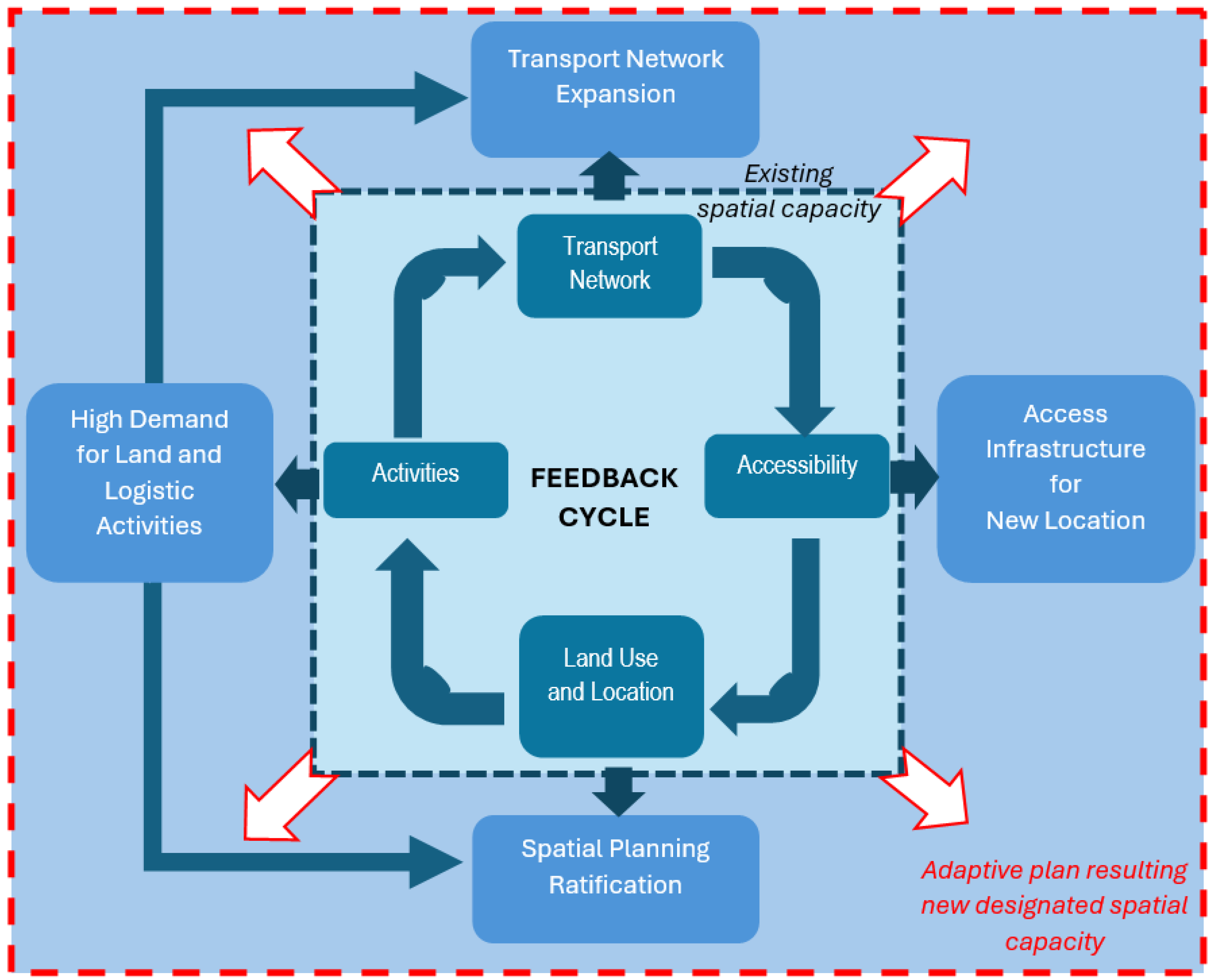
Figure 1. Scheme of the transport–land use feedback cycle. Source: Wegener and Fuerst [20] modified by the authors.
Land 14 02009 g001
Figure 2. Location of Jade Weser Port and the industrial estates. Source: City of Wilhelmshaven [44] modified by the authors.
Land 14 02009 g002
Figure 3. Existing transportation networks in the Wilhelmshaven and Jade Weser Port areas. Source: City of Wilhelmshaven [44] modified by the authors.
Land 14 02009 g003
Figure 4. Satellite images of transport network development in Voslapper and Rüstersieler Groden from 1985 to 2015. Source: Copernicus interpreted by the authors.
Land 14 02009 g004
Figure 5. Land use changes in Voslapper and Rüstersieler Groden from 1995 to 2020. Source: Copernicus interpreted by the authors.
Land 14 02009 g005
Figure 6. Spatial planning in Voslapper and Rüstersieler Groden from 1973 to 2002. Source: Series of spatial planning documents of City Wilhelmshaven.
Land 14 02009 g006
Figure 7. Intersection of the Wadden Sea National Park and the industrial zone. Source: Wadden Sea National Park [65] modified by authors. Left: Zone 2 is an intermediate area and as an interface between national park and industrial zone at Jade Bay. Right: Different category of specific zones in the Wadden Sea National Park.
Land 14 02009 g007
Figure 8. Ratification of spatial planning at the city level in 2007 and 2012. Source: City of Wilhelmshaven.
Land 14 02009 g008
Figure 9. Regional spatial planning (RROP) and transport network plan. Source: Government of Lower Saxony, 2012 and 2014 [49].
Land 14 02009 g009
Figure 10. Transport network development in Klaipeda Deep Seaport, Lithuania, before redevelopment (left) and the new deep seaport plan (right). Source: Klaipeda Seaport.
Land 14 02009 g010
Table 1. Analysis of planning documents.
Governmental LevelPlanning Documents
NationalRegulations about national parks
Regulations about ICZM
Regulation for seaport development in Germany
FederalRegional plans and concepts (RROP)
CityLand use plan (Flächennutzungsplan)
NeighborhoodMaster plan of Jade Weser Port
Table 2. Interrelation hypotheses and reality.
Real Land Use ChangesFundamental Changes in Transportation InfrastructureChanges in Nature ProtectionPlanning and Regulation
Demand for land on the seaside and landside in sensitive areasAgglomeration of new industrial areas and storage related to the seaport upon extension of the new transport network Increase in demand for new transportation networks that connect the outer area and seaport, reaching sensitive areasSea reclamation is decided to limit demand on the seaside and protect existing coastal areasChanges in the process of spatial plans and ratification toward investment-friendly planning
Planning process, feedback loops, and interventionA new transport network follows a new industrial area and vice versaNew logistic infrastructure (expansion plan) versus the limit of spatial capacityOngoing and future impacts on the protected areaAdaptive and compromise-driven land use planning of future scenarios (anticipative plan)
Disclaimer/Publisher’s Note: The statements, opinions and data contained in all publications are solely those of the individual author(s) and contributor(s) and not of MDPI and/or the editor(s). MDPI and/or the editor(s) disclaim responsibility for any injury to people or property resulting from any ideas, methods, instructions or products referred to in the content.